COASTAL CONSERVANCY. Staff Recommendation October 18, 2012 BAY AREA RIDGE TRAIL: MARTINEZ FEEDER TRAIL #1 CONSTRUCTION AND SURVEYING
|
|
|
- Eleanor Jefferson
- 5 years ago
- Views:
Transcription
1 COASTAL CONSERVANCY Staff Recommendation October 18, 2012 BAY AREA RIDGE TRAIL: MARTINEZ FEEDER TRAIL #1 CONSTRUCTION AND SURVEYING File No Project Manager: Melanie Denninger RECOMMENDED ACTION: Authorization to disburse up to $125,000 to the East Bay Regional Park District for construction of approximately 3 miles of a segment of the Bay Area Ridge Trail known as Martinez Feeder Trail #1, and surveying of an additional 0.7-mile segment of the same trail, west of the City of Martinez in unincorporated Contra Costa County. LOCATION: West of the City of Martinez in unincorporated Contra Costa County PROGRAM CATEGORY: San Francisco Bay Area Conservancy EXHIBITS Exhibit 1: Project Location Maps Exhibit 2: Site Map Exhibit 3: Project Photographs Exhibit 4: CEQA Documents Exhibit 5: Project Letters RESOLUTION AND FINDINGS: Staff recommends that the State Coastal Conservancy adopt the following resolution pursuant to Sections of the Public Resources Code: The State Coastal Conservancy hereby authorizes disbursement of an amount not to exceed $125,000 (one hundred twenty-five thousand dollars) to the East Bay Regional Park District (the Park District ) for construction of approximately 3 miles of a segment of the Bay Area Ridge Trail known as Martinez Feeder Trail #1, and surveying of an additional 0.7-mile segment of the same trail, west of the City of Martinez in unincorporated Contra Costa County, subject to the following conditions: 1. Prior to the disbursement of funds, the Park District shall submit the following for the review and approval of the Executive Officer of the Conservancy: Page 1 of 14
2 BAY AREA RIDGE TRAIL: MARTINEZ FEEDER TRAIL #1 CONSTRUCTION AND SURVEYING A. A detailed work program, budget, and schedule; B. A plan for the installation of a sign acknowledging Conservancy participation and displaying the Conservancy logo; and C. The names and qualifications of any contractors that it intends to employ. 2. The Park District shall ensure compliance with all project actions, components, and mitigation measures that are required by the Initial Study and Mitigated Negative Declaration for the East Bay Regional Park District Feeder Trail #1 Project certified by the Park District on September 18, 2012, and accompanying the project staff recommendation as Exhibit 4. Staff further recommends that the Conservancy adopt the following findings: Based on the accompanying staff report and attached exhibits, the State Coastal Conservancy hereby finds that: 1. The proposed project is consistent with the current Project Selection Criteria and Guidelines. 2. The proposed authorization is consistent with the purposes and objectives of Chapter 4.5 of Division 21 of the Public Resources Code, regarding the improvement of public access to, within, and around the bay, coast, ridgetops and urban open spaces of the San Francisco Bay area. 3. The Conservancy has independently reviewed the Initial Study and Mitigated Negative Declaration for the East Bay Regional Park District Feeder Trail #1 Project certified by the Park District on September 18, 2012 pursuant to the California Environmental Quality Act, and finds no substantial evidence that the project, with the identified measures to avoid, reduce or mitigate the possible significant environmental effects, will have a significant effect on the environment. PROJECT SUMMARY: This authorization would provide up to $125,000 to the East Bay Regional Park District (the Park District ) to construct improvements on 3 miles of the segment of the Bay Area Ridge Trail ( Ridge Trail ) known as Martinez Feeder Trail #1 (the Feeder Trail ) and to complete a survey of property boundaries along a contiguous 0.7-mile segment of the same trail needed for future extension of the trail. The proposed project is part of the Ridge Trail system in rolling rangeland between Pinole and Martinez in Contra Costa County and is needed to make an existing deteriorated fire road safe and usable by the public and to provide access to the Ridge Trail from the vicinity of Martinez (Exhibits 1 and 2). Trail construction will be undertaken by the Park District, with possible assistance from the either the California Conservation Corps or Civicorps, and includes activities such as grading at gully locations; replacing inadequate culverts and installing headwalls, Page 2 of 14
3 BAY AREA RIDGE TRAIL: MARTINEZ FEEDER TRAIL #1 CONSTRUCTION AND SURVEYING tailwalls and basins; installing articulated fords (interlocking concrete pavers); and stabilizing the trail with riprap. Surveying of property boundaries along the contiguous 0.7-mile proposed trail segment is necessary to enable future trail construction to link the Feeder Trail to access from Pereira Road and to the existing Ridge Trail in the East Bay Municipal Utility District s ( EBMUD s ) Pinole Watershed (Exhibits 1 and 2). While the Park District holds title to the entire 3.7-mile trail, the actual location of its property interest along the 0.7-mile segment may not entirely correspond to the existing ranch road and needs to be established. The Park District owns and operates an extensive system of regional parks in Alameda and Contra Costa Counties. It has been the recipient of many previous Conservancy grants and has shown itself to be a very capable and effective grant manager. Site Description: The Feeder Trail is located west of the City of Martinez and south of Highway 4 in unincorporated Contra Costa County (Exhibit 1). The trail right-of-way is owned by the Park District and is abutted by dedicated open space, a stable, and private ranchland. The open space includes the Gustin and Dutra Ranches, both acquired by the Muir Heritage Land Trust ( MHLT ) with Conservancy assistance, and MHLT s Sky Ranch. The northeastern end of the Feeder Trail will be at a staging area on Dutra Road on the outskirts of the City of Martinez and the southwestern end will be at Pereira Road where the existing Ridge Trail enters EBMUD property and also crosses MHLT s Franklin Canyon and Fernandez Ranch properties, which were acquired with Conservancy assistance. The Feeder Trail alignment mainly consists of a deteriorated fire road, with patches of weeds, annual grasslands, and a small amount of oak woodland on the perimeter. The surrounding area is characterized by rolling hills, ephemeral streams, mixed oak woodland, annual and perennial grassland, live oak/bay laurel woodland, and coastal scrub (Exhibit 3). The portion of the Feeder Trail closest to Pereira Road, where surveying will be done, also abuts an orchard. Project History: The Feeder Trail, originally a stagecoach route dating back to the 1850s, was designated as a feeder, or connector, to the California State Riding and Hiking Trail by the Contra Costa County Board of Supervisors in 1952, but was not maintained as such. Later, the Bay Area Ridge Trail Council ( BARTC ) identified the route of the Feeder Trail as the alignment of a segment of the Ridge Trail. In 2010, after years of negotiations, the Park District obtained title to the right-of-way from the County and, in cooperation with the BARTC, began designing the improvements needed to make the Feeder Trail safe and passable. In 2011, the Park District and BARTC approached Conservancy staff with a request for funding assistance for the proposed project and for additional trail planning nearby. At the present time, staff is only recommending that the Conservancy provide funding for Feeder Trail construction and surveying. As the private owners of one property between the Feeder Trail and the existing Ridge Trail, which continues north into Solano County, are not amenable to having a trail cross their property, the Park District s request for Conservancy assistance instead proposes to connect the Feeder Trail to a trailhead on a public road (Exhibit 2). Page 3 of 14
4 BAY AREA RIDGE TRAIL: MARTINEZ FEEDER TRAIL #1 CONSTRUCTION AND SURVEYING The vision for the Ridge Trail is a continuous 500-mile multi-use (serving hikers, mountain bicyclists and equestrians) trail that rings San Francisco Bay high on its adjacent ridgelines. Under the leadership of the Conservancy and BARTC, and supported by a diverse group of project participants, the Ridge Trail creates an interconnected system of open space and trails that provides recreational opportunities and scenic views to the public. Begun almost 20 years ago, over 300 miles of trail are now dedicated and/or open to the public in all nine Bay Area counties. This authorization will further the Conservancy s statutory and strategic goals of improving access around San Francisco Bay, and is consistent with previous Conservancy authorizations to negotiate and acquire trail easements, prepare trail construction plans and designs, and construct and open trail segments to the public. Feeder Trail #1 will also improve access to the MHLT s Franklin Canyon, Fernandez Ranch, Sky Ranch, Dutra Ranch and Gustin properties, most of which were acquired with Conservancy assistance for purposes including public access. PROJECT FINANCING: Coastal Conservancy $125,000 East Bay Regional Park District 25,900 Total Project Cost $150,900 The anticipated source of Conservancy funds for this grant is the fiscal year 2010/11 appropriation to the Conservancy from the Safe Drinking Water, Water Quality and Supply, Flood Control, River and Coastal Protection Bond Act of 2006 (Proposition 84). Proposition 84 funds may be used for the purposes of promoting access to and enjoyment of the coastal resources of the state in accordance with the provisions of the Conservancy s enabling legislation. (Pub. Resources Code section ) Consistent with the purposes of Proposition 84, the proposed project will be undertaken pursuant to the San Francisco Bay Area Conservancy Program (Chapter 4.5 of Division 21 of the Public Resources Code), as described below. The Park District will contribute additional funds of $25,900 toward the project. CONSISTENCY WITH CONSERVANCY S ENABLING LEGISLATION: Funding of the project is consistent with the Conservancy s San Francisco Bay Area Conservancy Program, Chapter 4.5 of the Conservancy s enabling legislation, Public Resources Code sections , which addresses the resource and recreational goals of the nine Bay Area counties in a coordinated, comprehensive, and effective way.. Pursuant to Section 31162(a) of the Public Resources Code, the Conservancy may award grants in the nine-county San Francisco Bay Area that will help to improve public access to, within, and around the ridgetops, consistent with the rights of private property owners, and without having a significant adverse impact on agricultural operations and environmentally sensitive areas and wildlife. Consistent with Section 31162(a), the proposed project is in Contra Costa County, one of the nine San Francisco Page 4 of 14
5 BAY AREA RIDGE TRAIL: MARTINEZ FEEDER TRAIL #1 CONSTRUCTION AND SURVEYING Bay Area counties; would improve public access to, within, and around the ridgetops between Sky Ranch and the Pinole Watershed; has been planned in consultation with the owners of surrounding private property, some of which is used for grazing cattle; has been designed to avoid or compensate for potential significant adverse impacts to environmentally sensitive areas; and is consistent with local planning efforts around the Ridge Trail. Consistent with Section 31163(a), the Conservancy cooperates with nonprofit land trusts and other organizations in identifying and adopting long-term resource and outdoor recreational goals for the San Francisco Bay Area. Completion of the Ridge Trail is identified in (1) The San Francisco Bay Area Conservancy Program Regional Needs Briefing Book (Bay Area Open Space Council, July 1999) and (2) 400 Miles and Beyond: A Strategic Plan for Completing the Bay Area Ridge Trail (BARTC, 2006). The Feeder Trail project satisfies all of the five criteria for determining project priority under Section 31163(c), as follows: the project is supported by adopted regional plans including the Park District s 1996 Master Plan as updated in 2007, the Ridge Trail alignment that has been adopted by the BARTC, and the 2009 Contra Costa Countywide Bicycle and Pedestrian Plan; serves a regional constituency by creating additional trail length for the Ridge Trail; can be implemented in a timely manner; provides benefits that could be lost if the project is not quickly implemented, such as ongoing deterioration of the fire road; and includes matching funds from the Park District. CONSISTENCY WITH CONSERVANCY S 2007 STRATEGIC PLAN GOAL(S) & OBJECTIVE(S): Consistent with Goal 11, Objective F of the Conservancy s 2007 Strategic Plan, the proposed project will result in completion of a trail right-of-way alignment survey needed for designing a 0.7-mile segment of the Ridge Trail. Consistent with Goal 11, Objective G of the Conservancy s 2007 Strategic Plan, the proposed project will result in construction of a 3-mile segment of the Ridge Trail. Consistent with Goal 11, Objective I of the Conservancy s 2007 Strategic Plan, the proposed project will result in construction of a link between the Ridge Trail and the City of Martinez. CONSISTENCY WITH CONSERVANCY S PROJECT SELECTION CRITERIA & GUIDELINES: The proposed project is consistent with the Conservancy s current Project Selection Criteria and Guidelines in the following respects: Required Criteria 1. Promotion of the Conservancy s statutory programs and purposes: See the Consistency with Conservancy s Enabling Legislation section above. Page 5 of 14
6 BAY AREA RIDGE TRAIL: MARTINEZ FEEDER TRAIL #1 CONSTRUCTION AND SURVEYING 2. Consistency with purposes of the funding source: See the Project Financing section above. 3. Support of the public: Public support of the proposed project is indicated by its inclusion in adopted regional plans such as the Park District s 1996 Master Plan as updated in 2007, the Ridge Trail alignment that has been adopted by the BARTC, and the 2009 Contra Costa Countywide Bicycle and Pedestrian Plan. In addition, letters of support from Congressman George Miller, State Senator Mark DeSaulnier, the Muir Heritage Land Trust and BARTC, are attached as Exhibit Location: The proposed project is located in Contra Costa County, within the jurisdiction of the San Francisco Bay Area Conservancy Program and will benefit the San Francisco Bay Region by adding 3 trail miles to the Ridge Trail system, providing a link between the Ridge Trail and an urban area, and completing the surveying component of the planning needed to further extend the Ridge Trail. 5. Need: Without Conservancy funding, the Park District would defer construction and surveying for the proposed project. The Conservancy is ideally suited to provide funding in a timely manner to ensure completion of the project. 6. Greater-than-local interest: The Ridge Trail is a major regional attraction and amenity. When completed, it will offer spectacular views of the entire Bay Area and will link many urban areas, parklands, and preserves. Completion of the Ridge Trail is one of the goals identified in the Bay Area Open Space Council s Regional Needs Briefing Book. The proposed project will result in improvements to the route of the Feeder Trail, making a trail connection between urban Martinez, Sky Ranch, and beyond, and completing the right-of-way survey needed to design the remaining Ridge Trail Connection between Martinez and the Pinole Watershed. 7. Sea level rise vulnerability: The project is located in an area that is not vulnerable to impacts due to anticipated rise in sea levels attributable to global climate change. Additional Criteria 8. Urgency: Environmental review has been completed. If the project is delayed, site conditions could change and the design and environmental review process might have to be redone. 10. Leverage: See the Project Financing section above. 13. Readiness: This project is ready to proceed as soon as funding is secured. 14. Realization of prior Conservancy goals: See the Project History section above. 16. Cooperation: The project has been developed in cooperation among the park District, the BARTC, and surrounding landowners 17. Minimization of greenhouse gas emissions: See the Compliance with CEQA section below. Page 6 of 14
7 BAY AREA RIDGE TRAIL: MARTINEZ FEEDER TRAIL #1 CONSTRUCTION AND SURVEYING COMPLIANCE WITH CEQA: Construction of 3 miles of the Feeder Trail Pursuant to the California Environmental Quality Act (CEQA), the Park District, as lead agency, prepared the Draft Initial Study and Mitigated Negative Declaration to provide the public and responsible and trustee agencies with information on the potential effects of the trail construction portion of the proposed project, which it calls East Bay Regional Park District Feeder Trail #1 Project. No comments were received during the 30-day public comment period. Following the close of the public comment period on August 31, 2012, the Park District prepared the Final Initial Study and Mitigated Negative Declaration (MND), adopted the MND on September 18, 2012, and shortly thereafter filed a Notice of Determination (NOD). The Park District has also paid the filing fee required by the Department of Fish and Game pursuant to Fish and Game Code section 711.4(c). The NOD and Final MND with mitigation measures are attached as Exhibit 4. In its MND, the Park District concluded that the project, as revised with the proposed mitigation measures, would not have significant impacts on the environment. The discussion that follows draws from the Park District s discussion of potentially significant impacts to air quality, biological resources, cultural resources, geology/soils, greenhouse gas emissions, hydrology and water quality, and noise and identifies the mitigation measures that it proposes to reduce the potentially significant impacts to less than significant with mitigation. Staff has independently reviewed the Park District s MND, concurs with its analysis and therefore recommends that the Conservancy adopt a finding that the project, as mitigated, does not have the potential for a significant effect on the environment. Staff also recommends that the Conservancy condition its approval of this project to require the Park District to implement all of the MND s mitigation measures. Staff will file a NOD upon approval of the project. Air Quality Potentially Significant Impacts: During the construction phase, sources of air emissions and dust include activities such as excavation, grading, vehicle travel on unpaved surfaces, and vehicle and equipment exhaust. Sensitive receptors for these emissions and dust in the project area include residential and recreational users, although the Feeder Trail itself will be closed during construction. The proposed project meets the screening criteria of the Bay Area Air Quality Management District (BAAQMD) for construction air quality impacts and, provided that the following mitigation measures are implemented, construction air quality impacts would be less than significant. Mitigation Measures: Page 7 of 14
8 BAY AREA RIDGE TRAIL: MARTINEZ FEEDER TRAIL #1 CONSTRUCTION AND SURVEYING To minimize dust associated with construction activities, the Park District and any contractor shall be required to employ the following Best Management Practices for managing dust: AQ-1 Regularly water access routes and construction areas using a water source which would either be self-propelled or attached to a vehicle; Excavate during calm periods; Cover all truck beds hauling soil, vegetation and other loose construction materials; Re-establish bare soils resulting from grading and staging activities [with the exception of the natural surface trail approaches] by applying stripping from the project site; Routinely cover, water or apply non-toxic soil binders to exposed stockpiled materials as appropriate; Maintain all equipment engines in good condition, in proper tune (per manufacturer s specifications), and in compliance with all State and Federal requirements; Limit traffic speed to 15 miles per hour; and suspend earth-moving activities if winds exceed 25 miles per hour and/or as directed by the Park District Inspector. Biological Resources Potentially Significant Impacts Potentially significant construction impacts to plants and animals include removal of vegetation during breeding seasons for birds, removal of trees and snags during maternity roosting seasons for bats, disturbance of the Alameda whipsnake during spring and summer, and disturbance of non-breeding habitat for the red-legged frog. These potentially significant impacts to biological resources will be reduced to lessthan-significant levels, provided that the following mitigation measures are implemented. Mitigation Measures BIO-1a Impacts to Raptors: The following measure was designed to ensure that treenesting raptors (e.g., hawks, falcons, kites) are not disturbed during the breeding season. A qualified biologist shall conduct a pre-construction survey for tree-nesting raptors in all trees occurring within 250 feet of the project route within 14 days of the onset of ground disturbance, if such disturbance will occur during the breeding season (February through August 31). I nesting raptors are detected on the site during the survey, a construction buffer of 250 feet shall be established Page 8 of 14
9 BAY AREA RIDGE TRAIL: MARTINEZ FEEDER TRAIL #1 CONSTRUCTION AND SURVEYING around each active nest for the duration of the breeding season or until it has been confirmed that all young have fledged. A biological monitor shall monitor the site to ensure nesting raptors are not adversely affected by construction activities, and to determine when young are independent. BIO-1b Impacts to Other Nesting Birds: Harming or disrupting nesting migratory birds and/or their eggs or young is prohibited under state and federal law, and therefore, would be a potentially significant impact. The following measures are designed to ensure that nesting special status and common nesting birds are not disturbed during the breeding season. To avoid impacting nesting birds (including California Department of Fish and Game (CDFG) Species of Special Consern), one of the following shall be implemented: BIO-2 Conduct grading and construction activities, including the removal of branch or snag removal, from September 1 through January 31, when birds are not likely to be nesting; OR Conduct pre-construction surveys for nesting birds if construction is to take place during the nesting season (February 1 through August 31). A qualified wildlife biologist shall conduct a pre-construction nest survey no more than 14 days prior to initiation of grading to provide confirmation of the presence or absence of active nests on or immediately adjacent to the project area. If active nests are encountered, species-specific measures shall be prepared by a qualified biologist and implemented to prevent abandonment of the active nest. At a minimum, grading in the vicinity of the nest shall be deferred until the young virds have fledged. A minimum exclusion buffer of 25 feet shall be maintained during construction, depending on the species and location. A qualified biologist shall serve as a construction monitor during those periods when construction activities occur near active nest areas to ensure that no inadvertent impacts on these nests occur. Impacts to Bats: If construction occurs during the roosting season (April through August), then pre-construction surveys for bats in suitable roost trees shall take place. If special status bat species are detected during surveys, an appropriate treatment plan shall be employed including postponing removal of branches or snags until the end of the maternity roosting season or construction of speciesappropriate roosting habitat in the vicinity of the project area. BIO-3a Impacts to Alameda Whipsnake: All Trail improvement and maintenance activities in the vicinity of suitable whipsnake habitat shall be conducted during the window established by the Army Corps of Engineers for routine maintenance activities, July Page 9 of 14
10 BAY AREA RIDGE TRAIL: MARTINEZ FEEDER TRAIL #1 CONSTRUCTION AND SURVEYING through October. Prior to the start of construction, a pre-construction survey shall be conducted by a qualified biologist in potential habitat areas. Suitable whipsnake habitat (coyote brush, sage scrub, and riparian scrub) shall be noted and flagged. Because work will be conducted during the active (dry) season for whipsnake, an on-site biological monitor shall be present during activities within 100 feet of chaparral and scrub habitat to reduce potential for harassment, injury or death of whipsnakes. BIO-3b Prior to initiation of construction activities, a qualified biologist shall train all site workers to ensure that all construction personnel, contractors and operators are aware of the potential presence of the whipsnake, recognize the ramifications of the taking of a listed species and receive training related to the whipsnake, including identification and protection measures, and requirements for responding to and reporting sightings. BIO-3c Pre-construction surveys to excavate and collapse any burrows or other retreats shall be conducted within one week of any construction activities involving vegetation removal near whipsnake habitat to prevent re-entry. Following pre-construction surveys, vegetation shall be removed by hand in the area to be graded with a biological monitor present. Three feet of silt fencing above the ground and at least six inches of fence trenched into the ground shall be required around staging and stockpiling areas to prevent incidental take of snakes that may enter the site during non-working hours. BIO-3d A qualified biologist shall be on-site throughout grading whenever work is being conducted within 100 feet of any suitable whipsnake habitat. The biologist shall be empowered to halt and suspend construction activities which could directly threaten the welfare of any whipsnake. If any whipsnakes are observed, work in the area shall be halted immediately until the snake leaves the area. If the whipsnake has moved and the biologist confirms that it is no longer in the vicinity of the work area, construction may resume. The whipsnake shall not be collected or moved by the field biologist, unless it in in imminent danger of being killed. If a whipsnake must be moved to avoid injuring or killing it, the whipsnake shall be re-located to suitable habitat a minimum of 0.5 mile from the point of capture. The biologist shall continue to search the exclusion area after construction has halted and check the exclusion fence to ensure the snake has left the area. The observation of any live or dead whipsnake within the construction area shall be reported within 24 hours to the U.S. Fish and Wildlife Service (USFWS) or CDFG. Written records of all biological monitoring activities shall be kept in a daily log at the project site. BIO-3e Page 10 of 14
11 BAY AREA RIDGE TRAIL: MARTINEZ FEEDER TRAIL #1 CONSTRUCTION AND SURVEYING To protect whipsnake and other wildlife from disturbance and human-induced predation during construction, dogs and/or other pets shall not be allowed on construction sites; and contractors and their employees shall not be allowed to bring pets onto the project site, including dogs kept either inside or outside of employee vehicles. BIO-f To minimize contamination and artificial increase of predators (i.e., raccoons) on construction sites and adjacent protected habitats, all food-related trash materials, e.g., leftovers, wrappers, and containers, shall be removed from the construction site daily. BIO-3g To minimize wildlife and habitat disturbance, all equipment and vehicle movement shall be confined to designated construction and staging areas and connecting roadways. Climate Change and Greenhouse Gas Emissions Potentially Significant Impacts The construction phase of the project includes grading and slope stabilization using mechanized equipment. Sources of construction-related greenhouse gas (GHG) emissions include exhaust, for which the same detailed guidance as described above for criteria air pollutants and precursors shall be followed. The BAAQMD CEQA Guidelines do not include screening criteria or thresholds of significance for construction-related GHG emissions. However, implementation of Mitigation Measure AQ-1 would ensure that construction-related GHG emissions would be less than significant. Mitigation Measures See Mitigation measure AQ-1. Cultural Resources Potentially Significant Impacts The project area is not known to contain archaeological resources, but it has a long history of human use, and has not undergone an exhaustive archaeological survey, so it is possible that such resources could exist along the trail. Therefore, the proposed project could result in potentially significant impacts to unknown cultural resources. However, implementation of the following mitigation measures would reduce potentially significant impacts to a less-than-significant level. Mitigation Measures CULT-1 Page 11 of 14
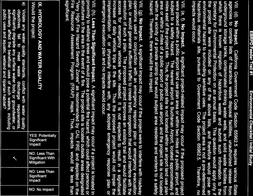
12 BAY AREA RIDGE TRAIL: MARTINEZ FEEDER TRAIL #1 CONSTRUCTION AND SURVEYING If potentially significant cultural resources or human remains are encountered during project excavation or construction, all activity in the vicinity of the suspect resources or remains shall be immediately suspended and the Park District and a qualified archaeologist shall be contacted to evaluate the situation. Project personnel shall not alter any of the uncovered materials or their context. The Park District, in consultation with a qualified archaeologist, in the case of cultural resources, shall complete a resource inventory, declaration, and mitigation plan prior to the continuation of any on-site grading or construction activity. Any previously undiscovered resources found during construction shall be recorded. Significant cultural resources consist of, but are not limited to, stone, bone, wood, and shell artifacts; fossils; and features including structural remains, stagecoach artifacts, and historic dumpsites. In the case of human remains, work shall cease until the county coroner makes a report. The county coroner is required to contact the Native American Heritage Commission within 24 hours if the coroner determines the remains to be Native American. Geology/Soils Potentially Significant Impacts A significant impact to soils if a project exposes large areas to the erosional effects of wind or water for a protracted period of time. The soils underlying the project site are classified as presenting slight to no hazard. Project construction activities, such as grading, may increase the potential for erosion to occur at the project site. The potentially significant impacts would be reduced by the implementation of a Stormwater Pollution Prevention Plan (SWPPP). With the implementation of Mitigation Measure HYD-1, impacts associated with the proposed project would be less than significant. Mitigation Measures See Mitigation Measure HYD-1. Hydrology and Water Quality Potentially Significant Impacts The proposed project includes the construction of storm water drainage infrastructure (culverts) which have been sized to accommodate estimated storm water flows. This runoff would flow generally northwestward through the culverts and ultimately drain to Rodeo Creek, which drains into San Pablo Bay. The project will not include any impervious area and is not anticipated to result in additional runoff during storm events. Operation of the project would not violate any water quality standards or significantly degrade any water body. However, during project construction, soil disturbances at the project site may impact water quality of storm water runoff. These potential impacts would be reduced by the implementation of a SWPPP. With the implementation of Mitigation Measure HYD-1, impacts associated with the proposed project would be less than significant. Page 12 of 14
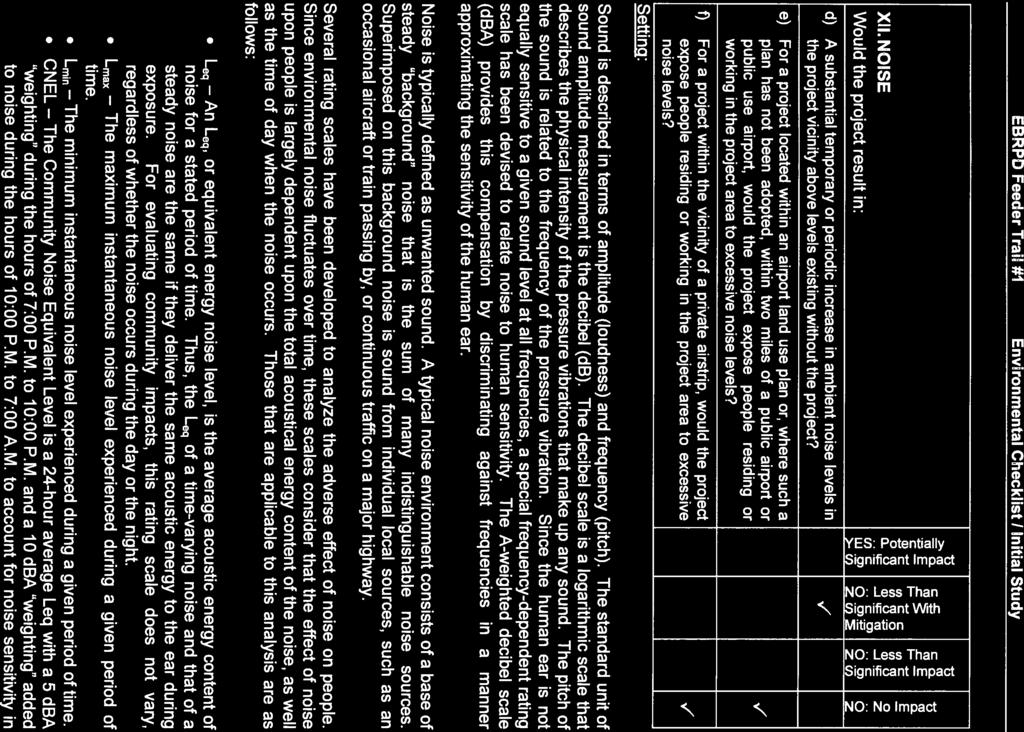
13 Mitigation Measures HYD-1 BAY AREA RIDGE TRAIL: MARTINEZ FEEDER TRAIL #1 CONSTRUCTION AND SURVEYING The Park District shall prepare a SSPPP which shall be implemented during construction and the following Best Management Practices (BMPs) shall be includedin the SWPPP to ensure that water quality of surface runoff is maintained and no siltation of downstream waterways occurs: To the extent possible, project grading shall take place in the dry season between July 1 and October 31 to minimize immediate erosion/siltation. Construction materials and waste shall be handled and disposed of properly in compliance with applicable law to prevent contact with storm water. Discharge of all potential pollutants, including petroleum products, chemicals, wash water or sediments, and non-storm water discharges to storm drains and watercourses shall be controlled and prevented. Sediment controls such as straw mulch, silt fences, sediment basins or traps and/or other measures shall be employed during construction. Tracking dirt or other materials off-site shall be avoided and off-site paved areas shall be cleaned regularly using dry sweeping methods. The Park District shall train and provide instruction to all employees and subcontractors regarding construction BMPs. Noise Potentially Significant Impacts A Significant impact may occur if the proposed project would generate excess noise that would cause the ambient noise environment at the project site to exceed noise levels in excess of local standards. Contra Costa County does not have a noise ordinance. The construction activities associated with the project may involve the use of heavy equipment such as tractors, loaders, and graders. Trucks would be used to deliver equipment and materials and to haul away waste materials. This equipment would generate temporary steady-state and episodic noise that would be heard both on and off the project site. The noisiest pieces of construction equipment, jack hammers and pavers, would not be used on the project. As with all construction equipment, noise levels would diminish rapidly with distance from the construction site. There are few residences located adjacent to the project route; along the majority of the route, adjacent property is open space or ranch land. However, residents near the Dutra Road terminus of the project could experience temporary, periodic, noticeable increases in noise levels during the project s construction period, even with implementation of the noise control measures. Therefore, project impacts related to temporary noise increases associated with project construction would be potentially significant, but adherence to the following mitigation measures to require compliance with local ordinances addressing construction hours and Page 13 of 14
14 BAY AREA RIDGE TRAIL: MARTINEZ FEEDER TRAIL #1 CONSTRUCTION AND SURVEYING practices would reduce potential noise impact during project construction and operation to a less-than-significant level. Mitigation Measures NOISE-1 In addition to compliance with existing local, State and federal regulations, the following measures shall be required for construction associated with the project: Construction activity shall be limited to the hours of 7:00 a.m. to 7:00 p.m. and to Monday through Saturday. All construction vehicle and equipment shall be fitted with working mufflers. All stationary noise-generating equipment, such as compressors, should be located as far as possible from existing houses. Machinery, including motors, shall be turned off when not in use. Mobile equipment shall not run idle near existing residences. Surveying 0.7 Miles of Possible Future Feeder Trail The surveying portion of the proposed project is categorically exempt from CEQA under section of Title 14 of the California Code of Regulations for information collection because it involves only basic data collection and research activities which will not result in a serious or major disturbance to an environmental resource, (14 California Code of Regulations Section 15306). Staff will file a Notice of Exemption upon Conservancy approval of the project. Page 14 of 14

15 Project Location Exhibit 1: Project Location Map
 Pereira Rd (public) Planned Ridge Trail Alignment FT#1 const.")
16 Carquinez Strait Exhibit 1: Project Location Map Crockett Hills Regional Park Franklin Canyon Fernandez Ranch Franklin Cyn Rd. Martinez Feeder Trail #1 Dutra Rd. Pinole Watershed Ferndale Rd Sky Ranch Mt Wanda Pereira Rd Alhambra Valley Rd. 0 3 miles Dedicated Ridge Trail FT#1 Const. (primary RT) Pereira Rd (public) Planned Ridge Trail Alignment FT#1 const. (community connector) RT survey/title search

17 Exhibit 2: Site Map Franklin Cyn Rd Franklin Canyon Construction 3 miles Gustin Ranch Dutra Ranch Sky Ranch Dutra Rd Planned Ridge Trail (not part of this project) Fernandez Ranch Surveying 0.7 mile Mt Wanda Pinole Watershed Ferndale Rd Alhambra Valley Rd Planned Ridge Trail on Pereira Rd 0.5 mile (not part of this project) Dedicated Ridge Trail Planned Ridge Trail Protected Lands Along Ridge Trail


18 Exhibit 3: Project Photographs View eastward from Feeder Trail #1 toward the nearby cities of Martinez and Concord. Looking into a leafy portion of Feeder Trail #1 from its northeast end at Dutra Road.

19 Exhibit 3: Project Photographs Typical existing erosion on Feeder Trail #1 to be eliminated by the construction project.


20 Exhibit 3: Project Photographs Typical existing water diversion trench to be replaced by sustainable project improvements. Typical eroding slope to be stabilized by the construction project.

21 Exhibit 3: Project Photographs Looking eastward from the Ferndale Road terminus of the construction project.

22 Exhibit 3: Project Photographs Looking westward from Ferndale Road into the area where surveying will be done to determine the alignment of the publicly owned right-of-way.

23

24

25

26


27
28


29
30

31


32

33

34

35

36

37

38

39

40

41
42


43

44

45

46

47

48

49

50

51

52

53

54

55
56


57

58

59

60

61
62

63

64
65

66

67

68

69

70

71
72

73
74

75

76

77

78

79

80
81

82

83

84

85

86

87

88

89

90

91
92
 is pleased to serve in partnership with the Coastal Conservancy, assisting with a competitive grant program offering State funds for acquisition, planning, and construction of the")
93 Exhibit 5: Project Letters Douglas Bosco, Chair September 12, 2011 Attn: Matt Gerhart State Coastal Conservancy 1330 Broadway, 13th Floor Oakland, CA Dear Chair Bosco, The Bay Area Ridge Trail Council (Council) is pleased to serve in partnership with the Coastal Conservancy, assisting with a competitive grant program offering State funds for acquisition, planning, and construction of the Bay Area Ridge Trail. We are creating an uninterrupted 550+ mile multi-use path on the ridgelines around San Francisco Bay and over 330 miles are now dedicated to enjoy today and protected for future generations. On September 8, 2011 the Ridge Trail Council Board of Directors voted to endorse a funding request from the East Bay Regional Park District (District) for up to $125,000 to help fund construction and survey work on a segment of the historic Feeder Trail #1 near Martinez, in northern Contra Costa County. The majority of the grant would support construction of new drainage structures, regrading of the trail tread and hillside stabilization along 3 miles of the Feeder Trail, including 2 miles of Ridge Trail and 1 mile that will serve as a crucial connector route to the nearby community. A small portion of the grant would fund survey and title research for an adjacent 0.7 mile of the historic route to the west. Conservancy funds would be matched by approximately $25,900 from the District. This grant supports the next logical phase leading to re-opening the historic Feeder Trail. Previously, a small Conservancy-funded grant helped support survey and title research necessary for the District to secure property control. Construction will allow 3 miles of multi-use trail access from Franklin Canyon to Alhambra Valley and across Muir Heritage Land Trust s Sky Ranch. Views of the East Bay from Carquinez Strait to Mt. Diablo will be available once the trail reopens. The Council is pleased to support this grant request based on significance for the Ridge Trail, as well as other public access and cultural benefits. Sincerely, Janet McBride, Executive Director Bay Area Ridge Trail Council
94 Exhibit 5: Project Letters


95 Exhibit 5: Project Letters September 20, 2012 Mr. Douglas Bosco, Chairman California Coastal Conservancy Board of Directors 1330 Broadway, 13th Floor Oakland, CA Dear Mr. Bosco: I write in strong support of the East Bay Regional Park District s funding application to the California Coastal Conservancy to allow for the construction of an approximately three mile stretch of the Bay Area Ridge Trail known as Martinez Feeder Trail #1, and surveying of an additional 0.7 mile- segment of the same trail, west of the City of Martinez in unincorporated Contra Costa County. Construction and survey of these important trail segments will help connect all 550+ miles of the Bay Area Ridge Trail and provide open public access to stunning views and treasured open spaces. As the State Senator who represents the area where the proposed trail will be located, I respectfully request the Board s approval of this funding request which will afford my constituents greater access to this scenic property. If you have any additional questions about this worthwhile project, please feel free to contact me at (925) Sincerely, MARK DESAULNIER MD:sm
96 Exhibit 5: Project Letters
COASTAL CONSERVANCY. Staff Recommendation September 22, 2011 BAY AREA RIDGE TRAIL: HOOD MOUNTAIN TO HIGHWAY 12
 COASTAL CONSERVANCY Staff Recommendation September 22, 2011 BAY AREA RIDGE TRAIL: HOOD MOUNTAIN TO HIGHWAY 12 File No. 11-039-001 Project Manager: Betsy Wilson RECOMMENDED ACTION: Authorization to disburse
COASTAL CONSERVANCY. Staff Recommendation December 2, 2004 COYOTE HELLYER COUNTY PARK BAY AREA RIDGE TRAIL
 COASTAL CONSERVANCY Staff Recommendation December 2, 2004 COYOTE HELLYER COUNTY PARK BAY AREA RIDGE TRAIL File No. 04-057 Project Manager: Amy Hutzel RECOMMENDED ACTION: Authorization to disburse up to
COASTAL CONSERVANCY. Staff Recommendation March 17, 2011 EAST-SLOPE SONOMA MOUNTAIN RIDGE TRAIL PLANNING
 COASTAL CONSERVANCY Staff Recommendation March 17, 2011 EAST-SLOPE SONOMA MOUNTAIN RIDGE TRAIL PLANNING File No. 11-008-01 Project Manager: Sam Jenniches RECOMMENDED ACTION: Authorization to disburse up
COASTAL CONSERVANCY. Staff Recommendation June 5, 2008 GUALALA BLUFF TRAIL OPERATIONS AND MAINTENANCE
 COASTAL CONSERVANCY Staff Recommendation June 5, 2008 GUALALA BLUFF TRAIL OPERATIONS AND MAINTENANCE File No. 08-047-01 Project Manager: Deborah Hirst RECOMMENDED ACTION: Consideration and possible Conservancy
COASTAL CONSERVANCY. Staff Recommendation March 25, 2004 SONOMA COUNTY COASTAL TRAIL, PHASE I. File No Project Manager: Richard Retecki
 COASTAL CONSERVANCY Staff Recommendation March 25, 2004 SONOMA COUNTY COASTAL TRAIL, PHASE I File No. 03-142 Project Manager: Richard Retecki RECOMMENDED ACTION: Authorization to disburse up to $455,000
ROAD AND TRAIL PROJECT APPROVAL
 ROAD AND TRAIL PROJECT APPROVAL www.marincountyparks.org Marin County Parks, 3501 Civic Center Dr, Suite 260, San Rafael, CA 94903 DATE: July 12, 2017 PRESERVE: Gary Giacomini Open Space Preserve PROJECT:
COASTAL CONSERVANCY. Staff Recommendation October 21, 2010 PETALUMA TRESTLE REHABILITATION DESIGN
 COASTAL CONSERVANCY Staff Recommendation October 21, 2010 PETALUMA TRESTLE REHABILITATION DESIGN Project No.: 10-017-01 Project Manager: Deborah Hirst RECOMMENDED ACTION: Authorization to disburse up to
National Forests and Grasslands in Texas
 United States Department of Agriculture Forest Service National Forests and Grasslands in Texas Sam Houston NF 394 FM 1375 West New Waverly, Texas 77358 Phone 936-344-6205 Dear Friends, File Code: 1950
COASTAL CONSERVANCY. Staff Recommendation November 6, 2008 SAN FRANCISCO BAY TRAIL: CANAL BOULEVARD CONSTRUCTION
 COASTAL CONSERVANCY Staff Recommendation November 6, 2008 SAN FRANCISCO BAY TRAIL: CANAL BOULEVARD CONSTRUCTION File No. 07-037-02 Project Manager: Michelle Jesperson RECOMMENDED ACTION: Authorization
Appendix A Appendix A (Project Specifications) Auk Auk / Black Diamond (Trail 44) Reroute
 Auk Auk / Black Diamond (Trail 44) Reroute") Appendix A (Project Specifications) Auk Auk / Black Diamond (Trail 44) Reroute I. Proposed Action: This project proposes to reroute approximately 1,800 feet of a 50 inch wide trail, off of private property
Appendix A (Project Specifications) Auk Auk / Black Diamond (Trail 44) Reroute I. Proposed Action: This project proposes to reroute approximately 1,800 feet of a 50 inch wide trail, off of private property
Decision Memo for Desolation Trail: Mill D to Desolation Lake Trail Relocation
 for Salt Lake County, Utah Uinta-Wasatch-Cache National Forest Salt Lake Ranger District 1. Background The present location of the Desolation Trail (#1159) between Mill D and Desolation Lake follows old
Rule Governing the Designation and Establishment of All-Terrain Vehicle Use Trails on State Land
 Rule Governing the Designation and Establishment of All-Terrain Vehicle Use Trails on State Land 1.0 Authority 1.1 This rule is promulgated pursuant to 23 V.S.A. 3506. Section 3506 (b)(4) states that an
Public Notice ISSUED: December 10, 2018 EXPIRES: January 9, 2019
 APPLICANT: REFER TO: St. Louis and Lake Counties Regional Rail Authority 2018-01942-ARC Public Notice ISSUED: December 10, 2018 EXPIRES: January 9, 2019 SECTION:404 - Clean Water Act 1. APPLICATION FOR
Chapter 4.0 Alternatives Analysis
 Chapter 4.0 Alternatives Analysis Chapter 1 accumulated the baseline of existing airport data, Chapter 2 presented the outlook for the future in terms of operational activity, Chapter 3 defined the facilities
Finn Creek Park. Management Direction Statement Amendment
 Finn Creek Park Management Direction Statement Amendment November 2013 Management Direction Statement Amendment Approved by: Jeff Leahy Regional Director, Thompson Cariboo BC Parks November 12, 2013 Date
Daisy Dean Trail 628/619 ATV Trail Construction
 Background and Purpose and Need The Daisy Dean ATV Trail Construction Project is located in the Little Belt Mountains, Musselshell Ranger District, Lewis and Clark National Forest approximately 32 miles
City of Durango 5.8 FUNDING TRAILS DEVELOPMENT
 5.8 FUNDING TRAILS DEVELOPMENT The City has been successful in establishing dedicated local funding sources as well as applying for grants to develop the City s trail system, having received nearly $2.4
Decision Memo Broken Wheel Ranch Equestrian Outfitter Special-Use Permit Proposed Action
 Decision Memo Broken Wheel Ranch Equestrian Outfitter Special-Use Permit USDA Forest Service Mississippi Bluffs Ranger District, Shawnee National Forest Jackson and Union Counties, Illinois Proposed Action
Cultural Resource Management Report Deer Valley 4wd Restoration and Blue Lakes Road Maintenance Project R
 Cultural Resource Management Report R2015-05-03-10005 Undertaking Description: The proposes to perform road maintenance and meadow restoration on the Deer Valley 4wd trail and road maintenance on the Blue
Williamson Rock/Pacific Crest National Scenic Trail (PCT) Project EIS. Notice of intent to prepare an Environmental Impact Statement.
 Project EIS. Notice of intent to prepare an Environmental Impact Statement.") [3411-15-P] DEPARTMENT OF AGRICULTURE Forest Service Angeles National Forest; Los Angeles County, CA Williamson Rock/Pacific Crest National Scenic Trail (PCT) Project EIS AGENCY: ACTION: Forest Service,
[3411-15-P] DEPARTMENT OF AGRICULTURE Forest Service Angeles National Forest; Los Angeles County, CA Williamson Rock/Pacific Crest National Scenic Trail (PCT) Project EIS AGENCY: ACTION: Forest Service,
DECISION MEMO. Rawhide Trail #7073 Maintenance and Reconstruction
 Page 1 of 6 Background DECISION MEMO USDA Forest Service Jefferson Ranger District Jefferson County, Montana Rawhide Trail #7073 is located in the Elkhorn Mountain Range approximately 10 miles east of
CHAPTER III: TRAIL DESIGN STANDARDS, SPECIFICATIONS & PERMITS
 CHAPTER III Trail Design Standards, Specifications & Permits This chapter discusses trail standards, preferred surface types for different activities, permits, and other requirements one must consider
Martinez General Plan 2035 White Paper TRAILS
 Martinez General Plan 2035 White Paper TRAILS November 2016 The Issue The draft Martinez General Plan 2035 and Draft Program Environmental Impact Report were released for public review on September 15,
Blueways: Rivers, lakes, or streams with public access for recreation that includes fishing, nature observation, and opportunities for boating.
 Parks, Open Space and Trails PRINCE WILLIAM COUNTY 2008 COMPREHENSIVE PLAN TRAILS PLAN CONTENTS The components of the trails plan are: Intent Definitions Goals, Policies, and Action Strategies Trails Map
COASTAL CONSERVANCY. Staff Recommendation May 27, 2010 SAN DIEGUITO RIVER PARK TRAILS PHASE II TRAIL DESIGN AND CONSTRUCTION
 COASTAL CONSERVANCY Staff Recommendation May 27, 2010 SAN DIEGUITO RIVER PARK TRAILS PHASE II TRAIL DESIGN AND CONSTRUCTION File No. 05-031-02 Project Manager: Christopher Kroll RECOMMENDED ACTION: Authorization
Coronado National Forest Santa Catalina Ranger District
 United States Department of Agriculture Forest Service Coronado National Forest Santa Catalina Ranger District File Code: 1950 Date: October 14, 2015 Dear Interested Party: The Santa Catalina Ranger District
OPEN SPACE. The Open Space Element describes the County s goals and policies with respect to open space areas and addresses the following topics:
 PURPOSE This element addresses open spaces for: the managed production of resources, outdoor recreation, public health and safety, and the preservation of natural resources. Amador County s open space
Blue River Trail Master Plan JSA to Town Hall June 2004
 Blue River Trail Master Plan JSA to Town Hall June 2004 Prepared for: Silverthorne Town Council Silverthorne SPORT Committee Department of Recreation and Culture Silverthorne Public Works Silverthorne
Bear Creek Habitat Improvement Project
 06/10/10 Bear Creek Habitat Improvement Project El Paso County, Colorado Pike National Forest and Colorado Springs Utilities Owned Land Report prepared by: Eric Billmeyer Executive Director Rocky Mountain
White Mountain National Forest Saco Ranger District
 United States Department of Agriculture Forest Service White Mountain National Forest 33 Kancamagus Highway Conway, NH 03818 Comm: (603) 447-5448 TTY: (603) 447-3121 File Code: 1950 Date: February 26,
FEASIBILITY CRITERIA
 This chapter describes the methodology and criteria used to evaluate the feasibility of developing trails throughout the study areas. Land availability, habitat sensitivity, roadway crossings and on-street
Chatsworth Branch Library Devonshire Street, Chatsworth, CA Thursday, November 16, :00-8:00 pm
 Chatsworth Branch Library 21052 Devonshire Street, Chatsworth, CA 91311 Thursday, November 16, 2017 6:00-8:00 pm Project Team County of Los Angeles Department of Parks and Recreation Kathline King Chief
DATE: January 19, WCA Governing Board. Johnathan Perisho, Project Manager. Mark Stanley, Executive Officer
 Item 14 DATE: January 19, 2017 TO: FROM: THROUGH: SUBJECT: WCA Governing Board Johnathan Perisho, Project Manager Mark Stanley, Executive Officer Item 14: Consideration of a resolution to accept an acquisition
Parkland County Municipal Development Plan Amendment Acheson Industrial Area Structure Plan
 Parkland County Municipal Development Plan Amendment Acheson Industrial Area Structure Plan New Plan Acheson Industrial Area Structure Plan Amendment Parkland County Municipal Development Plan Board Reference
Flow Stand Up Paddle Board Parkway Plan Analysis
 Regional Parks Department Jeffrey R. Leatherman, Director County of Sacramento Divisions Administration Golf Leisure Services Maintenance Rangers Therapeutic Recreation Services Flow Stand Up Paddle Board
This section evaluates the projected traffic operations and circulation impacts associated with the proposed upgrade and expansion of the LWRP.
 4.5 TRAFFIC AND CIRCULATION This section evaluates the projected traffic operations and circulation impacts associated with the proposed upgrade and expansion of the LWRP. 4.5.1 Environmental Setting Existing
DRAFT. Dorabelle Campground Rehabilitation
 DRAFT Dorabelle Campground Rehabilitation September 2012 1.1 REGIONAL SETTING AND PROJECT LOCATION The Dorabelle Campground is located on the western shore of Shaver Lake in Fresno County, California (Section
Bradley Brook Relocation Project. Scoping Notice. Saco Ranger District. United States Department of Agriculture Forest Service
 Bradley Brook Relocation Project United States Department of Agriculture Forest Service Scoping Notice White Mountain National Forest February 2011 For Information Contact: Jenny Burnett White Mountain
Stevenson Ranch Library The Old Road, Stevenson Ranch, CA Thursday, November 9, :00-8:00 pm
 Stevenson Ranch Library 25950 The Old Road, Stevenson Ranch, CA 91381 Thursday, November 9, 2017 6:00-8:00 pm Project Team County of Los Angeles Department of Parks and Recreation Kathline King Chief of
COASTAL CONSERVANCY. Staff Recommendation December 13, 2007 SANTA ANA RIVER PARKWAY. File No Project Manager: Mary Small
 COASTAL CONSERVANCY Staff Recommendation December 13, 2007 SANTA ANA RIVER PARKWAY File No. 07-097 Project Manager: Mary Small RECOMMENDED ACTION: Authorize disbursement of up to two million seven hundred
ETOBICOKE CREEK NORTH TRAIL PROJECT. May 18, 2017 at Michael Power High School 105 Eringate Drive, Etobicoke ON M9C 3Z7
 ETOBICOKE CREEK NORTH TRAIL PROJECT May 18, 2017 at Michael Power High School 105 Eringate Drive, Etobicoke ON M9C 3Z7 1 Purpose of Open House The purpose of today s open house is to present the design
EXECUTIVE SUMMARY PROGRAM DEVELOPMENT REPORT PURPOSE EXISTING SETTING EXPANDING PARKLAND
 EXECUTIVE SUMMARY PROGRAM DEVELOPMENT REPORT PURPOSE As the culmination of the first phase of the master planning process, this Program Development Report creates the framework to develop the Calero County
2.0 Physical Characteristics
 _ 2.0 Physical Characteristics 2.1 Existing Land Use for the Project The site is comprised of approximately 114 acres bounded by Highway 101 to the north, the existing town of Los Alamos to the east, State
Chuckanut Ridge Fairhaven Highlands EIS Scoping Concerns
 Chuckanut Ridge Fairhaven Highlands EIS Scoping Concerns Coalition of Southside Neighborhoods CSN Comments for Fairhaven Highlands EIS Scope Hearing, Jan 16, 2008 1 Chuckanut Ridge Hilly Terrain: Potential
Rural Rustic Road Program
 Virginia Department of Transportation s Rural Rustic Road Program Prepared by the Local Assistance Division Virginia Department of Transportation 1401 East Broad Street Richmond, Virginia 23219 Michael
COASTAL CONSERVANCY. Staff Recommendation May 27, 2010 SANTA CRUZ COUNTY MASTER COASTAL TRAIL PLAN. File No Project Manager: Laura Engeman
 COASTAL CONSERVANCY Staff Recommendation May 27, 2010 SANTA CRUZ COUNTY MASTER COASTAL TRAIL PLAN File No. 09-004 Project Manager: Laura Engeman RECOMMENDED ACTION: Authorization to disburse up to $250,000
ARTICLE 7 MOBILE HOME AND RECREATIONAL VEHICLE PARKS AND CAMPGROUNDS
 ARTICLE 7 MOBILE HOME AND RECREATIONAL VEHICLE PARKS AND CAMPGROUNDS Section 701. APPLICABILITY Where a municipality has no subdivision or land development ordinance the provisions of this article shall
COMMUNITY MEETING NOVEMBER 1, Wheaton Regional Park Pine Lake Trail
 COMMUNITY MEETING NOVEMBER 1, 2012 MEETING AGENDA I. Introduction of Project Team II. Trail Renovation Process III. Wheaton Regional Park IV. Pine Lake Trail Renovation Project V. Comments and Questions
Logo Department Name Agency Organization Organization Address Information 5700 North Sabino Canyon Road
 Logo Department Name Agency Organization Organization Address Information United States Forest Coronado National Forest 5700 North Sabino Canyon Road Department of Service Santa Catalina Ranger District
Continental Divide National Scenic Trail Legislative History and Planning Guidance
 Continental Divide National Scenic Trail Legislative History and Planning Guidance Legislation, Policy, and Direction Regarding National Scenic Trails The National Trails System Act, P.L. 90-543, was passed
VI. ALTERNATIVES TO THE MASTER PLAN C. RENOVATED EAST BUILDING ALTERNATIVE
 VI. ALTERNATIVES TO THE MASTER PLAN C. RENOVATED EAST BUILDING ALTERNATIVE INTRODUCTION The Renovated East Building Alternative would include the continued use of the renovated West Building and the renovation
ORDINANCE NO. JACKSON TOWNSHIP, CAMBRIA COUNTY
 ORDINANCE NO. JACKSON TOWNSHIP, CAMBRIA COUNTY AN ORDINANCE OF THE TOWNSHIP OF JACKSON AMENDING SECTIONS OF THE JACKSON TOWNSHIP ZONING ORDINANCE AS FOLLOWS: PROVIDING NEW DEFINITIONS OF CAMPGROUNDS, CAMPSITE,
2016 Regional Transportation Alternatives Program (TAP) Grant Application
 Grant Application") 2016 Regional Transportation Alternatives Program (TAP) Grant Application PROJECT TITLE: Yelm-Tenino Trail Extension Feasibility Study TRPC use only GENERAL PROJECT INFORMATION Agency or Organization City
2016 Regional Transportation Alternatives Program (TAP) Grant Application PROJECT TITLE: Yelm-Tenino Trail Extension Feasibility Study TRPC use only GENERAL PROJECT INFORMATION Agency or Organization City
ES Aircraft Deicing Document Identification Number Date: March 15, ) Activity Description:
 Activity Description:") ES-301-1.06 Aircraft Deicing Document Identification Number ES-301-1.06 Date: March 15, 2018 Document Owner: Keith Pass 1) Activity Description: Aircraft deicing is the application of aircraft deicing
ES-301-1.06 Aircraft Deicing Document Identification Number ES-301-1.06 Date: March 15, 2018 Document Owner: Keith Pass 1) Activity Description: Aircraft deicing is the application of aircraft deicing
PLANNING COMMISSION AGENDA REPORT May 10, Members of the Planning Commission. Joyce Parker-Bozylinski, Contract Planner
 PLANNING COMMISSION AGENDA REPORT May 10, 2007 TO: FROM: PROPOSAL: APPLICANT: RECOMMENDATION: Members of the Planning Commission Joyce Parker-Bozylinski, Contract Planner Approval of the Calabasas Trails
APPENDIX F List of Commitments
 APPENDIX F List of Commitments s Table F.1 Standard Mitigation Measures Mitigation Measure MnDOT Specification Number Status Update Description Status Update Utilities Provide early notice to utility operators
Virginia Department of Transportation s Rural Rustic Road Program
 Virginia Department of Transportation s Rural Rustic Road Program Prepared by the Local Assistance Division Virginia Department of Transportation 1401 East Broad Street Richmond, Virginia 23219 Michael
Georgetown-Lewes Rail/Trail Study. Rail/Trail Study: Cool Spring to Cape Henlopen State Park New Road Extension (House Resolution No.
 Georgetown-Lewes Rail/Trail Study Rail/Trail Study: Cool Spring to Cape Henlopen State Park New Road Extension (House Resolution No. 47) August 22, 2011 Presentation Outline Background Benefits Statewide
Fossil Creek Wild & Scenic River Comprehensive River Management Plan Forest Service Proposed Action - details March 28, 2011
 Fossil Creek Wild & Scenic River Comprehensive River Management Plan Forest Service Proposed Action - details March 28, 2011 Primary Goals of the Proposed Action 1. Maintain or enhance ORVs primarily by
Alternative 3 Prohibit Road Construction, Reconstruction, and Timber Harvest Except for Stewardship Purposes B Within Inventoried Roadless Areas
 Roadless Area Conservation FEIS Summary Table S-1. Comparison of Key Characteristics and Effects by Prohibition Alternative. The effects summarized in this table A would occur in inventoried roadless areas
Welcome KROSNO CREEK DIVERSION PROJECT CLASS ENVIRONMENTAL ASSESSMENT
 Welcome KROSNO CREEK DIVERSION PROJECT PUBLIC INFORMATION CENTRE # 1 Tonight s Presentation Study Overview Background Existing Conditions Alternative Solutions Preliminary Preferred Solution Next Steps
SUMMER VILLAGE OF SILVER SANDS. Municipal Development Plan
 SUMMER VILLAGE OF SILVER SANDS Municipal Development Plan Bylaw 253-2014 Adopted August 22, 2014 Summer Village of Silver Sands Municipal Development Plan Bylaw No. 253-2014 Page 2 1 INTRODUCTION 1.1 SETTING
Appendix 1: Best Management Practices For Hang Gliding and Paragliding in Jasper National Parks
 Appendix 1: Best Management Practices For Hang Gliding and Paragliding in Jasper National Parks Name of Best Management Practice Best Management Practices for Hang Gliding and Paragliding in Jasper National
MONTEREY REGIONAL AIRPORT MASTER PLAN TOPICAL QUESTIONS FROM THE PLANNING ADVISORY COMMITTEE AND TOPICAL RESPONSES
 MONTEREY REGIONAL AIRPORT MASTER PLAN TOPICAL QUESTIONS FROM THE PLANNING ADVISORY COMMITTEE AND TOPICAL RESPONSES Recurring topics emerged in some of the comments and questions raised by members of the
Section 4(f) and Section 6(f) Technical Analysis
 and Section 6(f) Technical Analysis") WESTSIDE SUBWAY EXTENSION PROJECT Contract No. PS-4350-2000 Section 4(f) and Section 6(f) Technical Analysis Prepared for: Prepared by: WSP USA 851 SW Sixth Avenue, Suite 1600 Portland, Oregon 97204 FEBRUARY
WESTSIDE SUBWAY EXTENSION PROJECT Contract No. PS-4350-2000 Section 4(f) and Section 6(f) Technical Analysis Prepared for: Prepared by: WSP USA 851 SW Sixth Avenue, Suite 1600 Portland, Oregon 97204 FEBRUARY
COMMENT PERIOD INTRODUCTION
 To: Interested Persons From: Tom Buford File: Del Rio Trail Project Date: June 8, 2018 Community Development Department Reference: NOTICE OF PREPARATION OF AN ENVIRONMENTAL IMPACT REPORT FOR THE DEL RIO
Longmont to Boulder Regional Trail Jay Road Connection DRAFT FINAL REPORT
 Longmont to Boulder Regional Trail Jay Road Connection DRAFT FINAL REPORT December 2018 Project Summary Boulder County, Colorado, in partnership with the City of Boulder, is evaluating options for multi-use
Global Sustainable Tourism Destinations Criteria
 Global Sustainable Tourism Destinations Criteria Draft destination level Global Sustainable Tourism Criteria as proposed after Destinations and International Standards joint working group meeting and follow-up
Theme: Predominately natural/natural appearing; rustic improvements to protect resources. Size*: 2,500 + acres Infrastructure**:
 Recreation Opportunity Spectrum (ROS) Classes The Recreation Opportunity Spectrum (ROS) provides a way to describe the variations in the degree of isolation from the sounds and influences of people, and
M E M O R A N D U M. Status of the Environmental Cleanup of the Shipyard
 ECONOMIC AND WORKFORCE DEVELOPMENT MICHAEL COHEN, DIRECTOR CITY AND COUNTY OF SAN FRANCISCO GAVIN NEWSOM, MAYOR M E M O R A N D U M TO: Members of the Health Commission FROM: Michael Cohen CC: Mitch Katz,
Mountain Valley Pipeline, LLC Mountain Valley Pipeline Project Docket No. CP
 16. Prior to construction, Mountain Valley shall file with the Secretary, for review and approval by the Director of OEP, a segment-specific construction and operation access plan for the area between
David Magney Environmental Consulting
 David Magney Environmental Consulting DELINEATION OF JURISDICTIONAL WATERS AND RIPARIAN HABITATS FOR LYONS CANYON RANCH, NEWHALL, CALIFORNIA Prepared for: UNITED STATES ARMY CORPS OF ENGINEERS and CALIFORNIA
With the first portion of this process complete, we anticipate the general timeline for the remainder of the process to be:
 THE CITY OF FIRE RESCUE E D M O N T O N FIRE RESCUE SERVICES 10351 96 Street Edmonton, Alberta T5H 2H5 April 19, 2013 Dear Rossdale residents: As many of you know, Fire Rescue Services is currently in
RESPONSE TO AIRPORT EXPANSION CONSULTATION 27 MARCH 2018 Submitted online by Helen Monger, Director
 RESPONSE TO AIRPORT EXPANSION CONSULTATION 27 MARCH 2018 Submitted online by Helen Monger, Director 1. Expanding Heathrow The expansion of Heathrow will be one of the largest infrastructure projects in
Decision Memo Ice Age Trail Improvement (CRAC 37)
") Decision Memo Ice Age Trail Improvement (CRAC 37) U.S. Forest Service Chequamegon-Nicolet National Forest, Medford-Park Falls Ranger District Taylor County, Wisconsin T32N, R2W, Town of Grover, Section
Decision Memo Ice Age Trail Improvement (CRAC 37) U.S. Forest Service Chequamegon-Nicolet National Forest, Medford-Park Falls Ranger District Taylor County, Wisconsin T32N, R2W, Town of Grover, Section
MESA COUNTY DEPARTMENT OF PUBLIC WORKS Administration - Building - Engineering Road and Bridge Traffic - Planning - Solid Waste Management
 MESA COUNTY DEPARTMENT OF PUBLIC WORKS Administration - Building - Engineering Road and Bridge Traffic - Planning - Solid Waste Management 200 S. Spruce St. P.O. Box 20,000 Grand Junction, Colorado 81502-5022
RUSHMORE CONNECTOR TRAIL PROPOSAL
 PURPOSE AND NEED Background The U.S. Forest Service, Black Hills National Forest (Forest Service) has received a special use permit application from the State of South Dakota Department of Game, Fish and
BACKGROUND DECISION. Decision Memo Page 1 of 6
 DECISION MEMO DEVIL S ELBOW BY-PASS, BOUNDARY TRAIL NO.1 U.S. FOREST SERVICE T9N, R7E, SECTION 9 RANGE 5E COWLITZ COUNTY WA MOUNT ST. HELENS NATIONAL VOLCANIC MONUMENT, GIFFORD PINCHOT NATIONAL FOREST
12, 14 and 16 York Street - Amendments to Section 16 Agreement and Road Closure Authorization
 REPORT FOR ACTION 12, 14 and 16 York Street - Amendments to Section 16 Agreement and Road Closure Authorization Date: April 27, 2018 To: Toronto and East York Community Council From: Senior Strategic Director,
2. Goals and Policies. The following are the adopted Parks and Trails Goals for Stillwater Township:
 D. PARKS AND TRAILS 1. Introduction Stillwater Township s population is relatively low, with most residents living on rural residences on large lots. The need for active park space has been minimal in
METROPOLITAN COUNCIL 390 North Robert Street, St. Paul, MN Phone (651) TDD (651)
 TDD (651)") DATE: March 27, 2012 METROPOLITAN COUNCIL 390 North Robert Street, St. Paul, MN 55101 Phone (651) 602-1000 TDD (651) 291-0904 TO: Metropolitan Parks and Open Space Commission FROM: Arne Stefferud, Planning
DATE: March 27, 2012 METROPOLITAN COUNCIL 390 North Robert Street, St. Paul, MN 55101 Phone (651) 602-1000 TDD (651) 291-0904 TO: Metropolitan Parks and Open Space Commission FROM: Arne Stefferud, Planning
Appendix 3. Greenway Design Standards. The Whitemarsh Township Greenway Plan
 Appendix 3 Greenway Design Standards This chapter discusses two design standards for the greenway types discussed above. First, trail design standards are presented together with trailhead facilities and
MASTER PLAN EXECUTIVE SUMMARY
 Biscuit Run State Park Scottsville Road (State Route 20) Charlottesville, VA 22902 Biscuit Run State Park MASTER PLAN EXECUTIVE SUMMARY Department of Conservation and Recreation Division of Planning and
112th CONGRESS. 1st Session H. R. 113 IN THE HOUSE OF REPRESENTATIVES
 HR 113 IH 112th CONGRESS 1st Session H. R. 113 To provide for additions to the Cucamonga and Sheep Mountain Wilderness Areas in the Angeles and San Bernardino National Forests and the protection of existing
Airport Planning Area
 PLANNING AREA POLICIES l AIRPORT Airport Planning Area LOCATION AND CONTEXT The Airport Planning Area ( Airport area ) is a key part of Boise s economy and transportation network; it features a multi-purpose
AGENDA ITEM 5 D WAKULLA ENVIRONMENTAL INSTITUTE (WEI) TRAIL FEASIBILITY STUDY
 TRAIL FEASIBILITY STUDY") March 19, 2018 AGENDA ITEM 5 D WAKULLA ENVIRONMENTAL INSTITUTE (WEI) TRAIL FEASIBILITY STUDY TYPE OF ITEM: Action STATEMENT OF ISSUE The Wakulla Environmental Institute (WEI) Trail is one of several trails
March 19, 2018 AGENDA ITEM 5 D WAKULLA ENVIRONMENTAL INSTITUTE (WEI) TRAIL FEASIBILITY STUDY TYPE OF ITEM: Action STATEMENT OF ISSUE The Wakulla Environmental Institute (WEI) Trail is one of several trails
FINAL TESTIMONY 1 COMMITTEE ON RESOURCES UNITED STATES HOUSE OF REPRESENTATIVES. July 13, 2005 CONCERNING. Motorized Recreational Use of Federal Lands
 FINAL TESTIMONY 1 STATEMENT OF DALE BOSWORTH CHIEF Of the FOREST SERVICE UNITED STATES DEPARTMENT OF AGRICULTURE Before the SUBCOMMITTEE ON FORESTS AND FOREST HEALTH And the SUBCOMMITTEE ON NATIONAL PARKS,
January 14, Orange County Transportation Authority Attn: M2 NCCP/HCP 550 South Main Street P.O. Box Orange, CA
 Equestrian Trails, Inc. Corral 357 P.O. Box 1026 Trabuco Canyon, CA 92678 http://saddlebackcanyonriders.com/ President: James Iacono... 714-612-1789 January 14, 2016 Orange County Transportation Authority
DECISION MEMO North Zone (Legacy Trails) Trail Stabilization Project
 Trail Stabilization Project") DECISION MEMO North Zone (Legacy Trails) Trail Stabilization Project USDA FOREST SERVICE Rocky Mountain Region (R2) Shoshone National Forest Wapiti and Greybull Ranger District Park County, Wyoming Background
DECISION MEMO North Zone (Legacy Trails) Trail Stabilization Project USDA FOREST SERVICE Rocky Mountain Region (R2) Shoshone National Forest Wapiti and Greybull Ranger District Park County, Wyoming Background
Understanding user expectations And planning for long term sustainability 1
 Understanding user expectations And planning for long term sustainability 1 What is a natural surface trail? It can be as simple has a mineral soil, mulched or graveled pathway, or as developed as elevated
Community Development
 Community Development City & Borough of Juneau Community Development 155 S. Seward Street Juneau, AK 99801 (907) 586 0715 Phone (907) 586 4529 Fax DATE: February 11, 2016 TO: FROM: Planning Commission
Section 3.6 Recreation
 3.6 RECREATION This section evaluates the potential impacts of the proposed project on recreation within MTRP. The evaluation is based on field observations, a review of maps of MTRP and the MTRP Master
PROPOSED ACTION South 3000 East Salt Lake City, UT United States Department of Agriculture
 United States Department of Agriculture Forest Service Uinta-Wasatch-Cache National Forest Salt Lake Ranger District 6944 South 3000 East Salt Lake City, UT 84121 801-733-2660 File Code: 1950/2300 Date:
THRESHOLD GUIDELINES FOR AVALANCHE SAFETY MEASURES
 BRITISH COLUMBIA MINISTRY OF TRANSPORTATION & INFRASTRUCTURE AVALANCHE & WEATHER PROGRAMS THRESHOLD GUIDELINES FOR AVALANCHE SAFETY MEASURES British Columbia Ministry of Transportation & Infrastructure
Non-motorized Trail Plan & Proposal. August 8, 2014
 Town of Star Valley Ranch, Wyoming and the Star Valley Ranch Association in partnership with the USDA Forest Service, Bridger-Teton National Forest, Greys River Ranger District Non-motorized Trail Plan
WORKSHEET 1 Wilderness Qualities or Attributes Evaluating the Effects of Project Activities on Wilderness Attributes
 WORKSHEET 1 Wilderness Qualities or Attributes Evaluating the Effects of Project Activities on Wilderness Attributes Date: 3/7/2017 Roadless Area: Ruby South Description of Project Activity or Impact to
WASHINGTON STATE PARKS AND RECREATION COMMISSION POLICY/PROCEDURE
 WASHINGTON STATE PARKS AND RECREATION COMMISSION POLICY/PROCEDURE 65-13-1 Use of Other Power-Driven Mobility Devices by Persons with Mobility Disabilities at State Park Facilities See Also: 28 CFR 35 Title
CITY OF PALMDALE. REPORT to the Mayor and Members of the City Council from the City Manager
 CITY OF PALMDALE REPORT to the Mayor and Members of the City Council from the City Manager DATE: June 4, 2014 SUBJECT: Specific Plan Amendment 14-01; Amending the Use Designation of 23.97 Acres within
SAN MATEO COUNTY AGRITOURISM GUIDELINES
 SAN MATEO COUNTY AGRITOURISM GUIDELINES The San Mateo County Planning and Building Department and the San Mateo County Agricultural Advisory Committee s subcommittee on agritourism have developed the following
Header i
 Header i 048285014.10 Header Sub Title Body Text here. Body text here. Body text here. Section 1... 1 Executive Summary... 1 Opportunities and Constraints... 3 Overall Opportunities and Constraints Map