Horse Riding. in South Somerset. With six self-guided rides
|
|
|
- Aron Erik Atkinson
- 5 years ago
- Views:
Transcription


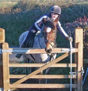


1 Horse Riding in South Somerset With six self-guided rides


2 Equine tourism is big business For thousands of years the human race has relied on the horse for work and play and today horses still play a vital role in the rural economy. This leaflet is designed to appeal to horse lovers: those that have their own horses and want new and interesting routes, those who have never ridden before but would like to try ambling through peaceful, beautiful countryside and those that would like to go to the races or watch a game of polo. I do hope you enjoy a happy equine holiday in Somerset. Best wishes Ewen Cameron, Lord Cameron of Dillington. 2


3 Please Ride Responsibly Be safe, plan ahead and follow any signs. Keep to the promoted route or other public bridleway, restricted byway or public road. Leave gates and property as you find them. Protect plants and animals and take your litter home. Keep dogs under close control. Ride slowly past other path users and any stock on farmland. Give way to pedestrians. Take special care when riding on country roads. Remember that horses hooves can damage surfaces in wet weather. 3


4 4
5 Six self guided routes 1 Corton Denham Ridge Ride Page 6 2 Limington Level Loop Page 8 3 Neroche-Staple Fitzpaine Herepath Page 10 4 Poyntington Hill Ridge Ride Page 12 5 Wambrook Wander Page 14 6 Willows and Wetland Ride Page 16 7 South Somerset map Page 18 Accommodation, events and suppliers Accommodation Page 20 Equine Dentist Page 21 Equine Goods Page 22 Events Page 23 Farriers Page 24 Livery Yards and Riding Schools Page 24 Vets Page 25 Equine Website Page 25 Feedback form Page 25 Tourist Information Centres Page 27 Equine route abbreviations Fgate - field gate Bgate - bridlegate SP - signposted TL - turn left TR - turn right BL - bear left BR - bear right LHS - left hand side RHS - right hand side SA - straight ahead Xroads - cross roads BW - bridleway 5

6 1 Corton Denham Ridge Ride A short ride following enclosed tracks, open fi elds and quiet roads, enjoying some of the most stunning views in the area across the picturesque South Somerset countryside. The ride is approximately 5 miles in length Follow road towards Corton Denham, after passing No Through Road to Whitcombe Farm, TL to follow Beacon Lane uphill. At end of road SA through gate on L and next gate keeping boundary on LHS. Through gate into enclosed lane, at end of lane TR onto road. At end of road TL towards Holway and Sandford Orcas. On bend in road with grass triangle TR to follow No Through Road, at junction with BW TR. At end of enclosed section through gate into open field SA keeping boundary on RHS, at end of field through gate on RHS and then through gate on LHS, TR keeping boundary on RHS. SA through next 2 gates keeping boundary on RHS. Through gate and follow sunken track, at fork of track, keep L through bgate into enclosed section and then onto road, TR and return to point 1. 6


7 Parking for this route is available at the Bramble and Sage Farm Shop by prior arrangement. Contact Home Farm, Sutton Montis, Somerset. BA22 7HF tel or To join the route at point 1 exit car park and take road opposite towards Corton Denham. 1 Sutton Farm Whitcombe Sigwells Girt The Beacon Corton Ridge Woodhouse 2 Down Farm 4 Corton Denham 3 Seven Wells Down Stafford s Green Poyntington Down Sandford Orcas Crown copyright. All rights reserved. South Somerset District Council - LA Bramble and Sage Farm Shop We have left no stone unturned whilst delving into the depths of Somerset and Dorset in sourcing the very best local, organic, artisan and freshest produce the area has to offer. From our own lamb and free range eggs, fresh bread and vegetables and tempting deli products. Drop in for coffee and homemade cake. 7
8 2 Limington Level Loop A level ride of 13 miles following quiet country roads and bridleways TR onto road towards Ashington. TR follow BW SP Yeovil Marsh, Hook Drove. At end of enclosed section SA keeping boundary on RHS, SA through Bgate and then Fgate into enclosed section and then bear right through Bgate into tree-lined track. Continue SA through Bgate then Fgate to reach tarmac road, through Bgate next to cattlegrid and SA to T-junction. TL towards Mudford and Ashington, at end of road TL to Ashington, before left hand bend in road and the hamlet of Ashington, TR along BW SP Chilton Cantelo. SA following headland path with boundary on LHS, through Bgate over bridge through Bgate and bear right across fields to go through Bgate and Fgate into track. Along track, then TL along road. Follow road through Chilton Cantelo and past sewage works. On sharp RH bend TL through bgate SP Yeovilton. Beware of low flying aeroplanes. SA following BW across field towards bridge. TL before bridge and follow river on RHS. Through Bgate, keeping river on RHS, at end of field TR over bridge and through gate. TL follow fence on RHS, then hedge. In corner of fi eld TR through bgate SA (do not cross bridge on left). Leave river at bend keeping telegraph poles on LHS towards fence through gate SA through gate onto road. TL past Yeovilton Weir, over bridge and then TR through gate to follow BW SP Yeovilton & Limington head diagonally left across field through Bgate, diagonally left across field to next Bgate, through this, follow river on LHS, over bridge SA, TL through gate over bridge, follow LH boundary, through gate onto road SA. At end of lane TR towards Ilchester. TL along BW SP Elborough Lane, at end of enclosed section follow boundary on LHS, at end of headland path TR keeping boundary on LHS. TL into enclosed lane, SA though gate, TL following wide drove to return to point 1. 8
9 Parking is available at the Lamb and Lark pub at Limington by prior arrangement. Contact Lamb and Lark, Limington, Somerset. BA22 8EG tel or To join route at point 1 exit car park and TR. 7 Elborough Lane Yeovilton 1 6 Limington Hooke Drove Draycot Speckington 5 Ashington 3 4 Chilton Cantelo Mudford A37 Yeovil Marsh 2 Mudford Sock Yeovil Crown copyright. All rights reserved. South Somerset District Council - LA The Lamb & Lark - Come and join us with a log fi re in the winter, oak beams and a really friendly atmosphere. Enjoy superb food, a choice of quality ales, lagers and a welcome glass of wine served at the comfortable bar. Our cosy restaurant serves delicious home-style cooking, a traditional Sunday roast and scrumptious deserts. Beer garden with ample seating. 9
10 3 Neroche - Staple Fitzpaine Herepath A 12 mile ride through the Neroche Forest and surrounding area, a peaceful ride with magnifi cent views across Somerset with a variety of riding from forest tracks and quiet country roads to cross fi eld bridleways. Can be muddy in places after wet weather At T-junction TR on road then TL on road SP Badger Street and Taunton. TR onto BW at Thurlbear wood, follow BW SA Keep left on smaller stoned track at culvert, keep left following BW out of wood. Through ford to Church Farm Thurlbear, TL on to road, (in the future there will be BW on LHS before end of road follow this to road and straight across road to point 2) at end of road TR Caution Busy Road. TL along first turning on road SP No Through Road Netherclay. At end of road follow stoned BW between horse paddocks to wooden Fgate SA follow stoned track to left, at Xroad of paths TL through Bgate SA, at wider stoned track TL uphill. On corner follow smaller stoned BW to R, SA through Bgate, SA keeping field boundary on LHS through Fgate across field diagonally to left. Before BW exits onto road TR and follow headland BW keeping field boundary on LHS. SA to farm buildings, through Bgate to right of buildings, follow to end of buildings then TL, follow track around to right, TL through Fgate into Staple Park Wood to follow BW and stoned track, through Fgate onto road and TR. At end of road SA through wooden Bgate. Follow BW SA uphill, before reaching top of hill TL onto stone track following BW through Fgate, TR and keep boundary on RHS, at Xroads of paths TL following Restricted Byway downhill towards Mount Fancy Farm. Before going through wooden gate follow BW to right and follow track across common. Through Bgate SA across field to Bgate, SA across field through gap in ancient hedgebank into sunken lane. TR through Bgate follow track on left. Follow main stoned track SA through woodland, at fork of tracks keep left on main track to road, through Bgate. Cross road Caution Busy Road through Bgate SA follow stoned track go past right turn SP short cut to car park, take next track on right and follow stoned track to wooden Fgate, through gate SA Xroad follow track to wooden Fgate through gate SA. Where track emerges from woodland TL then TR following stoned track, through Fgate onto road. At road TL on to road, after short distance TR onto BW and follow enclosed lane, at end of lane TL on to road. At end of road TR SP Hatch Beauchamp. Pass RSPCA Animal Rescue Centre. Farmers Arms is on RHS before end of road.

11 Parking for this route is available at the Farmers Inn, Slough Green by prior arrangement. Contact the Farmers Inn, Slough Green, Higher West Hatch, Taunton, Somerset, TA3 5RS tel or To join route at point 1 exit car park and TR. Netherclay Badger Street Thurlbear 2 1 Slough Green West Hatch Staple Park Wood 4 Staple Lawns 3 Staple Fitzpaine Whitty Curland Common Blackwater Blindmoor Crown copyright. All rights reserved. South Somerset District Council - LA Farmers Inn - A friendly, relaxed pub with wooden fl oors, a fi re, leather sofas and a light, airy restaurant. All food, from bar snacks to our à la carte menu, is imaginatively cooked using only the best quality, locally sourced ingredients. The pub and restaurant also feature an interesting wine list as well as local ales and ciders that have never travelled far. Accommodation is also available. 11


12 4 Poyntington Hill Ridge Ride A short ride following enclosed tracks, open fi elds and quiet roads, enjoying some of the most stunning views in the area across the picturesque South Somerset countryside. The ride is approximately 4 miles TR through gate onto BW following Donkey Lane, at end of enclosed section SA through gate keeping boundary on RHS. SA through gate, SA through gate into enclosed lane, where enclosed section meets track TL SP Poyntington Hill. TR after 50 metres, through gate SA in open field keeping boundary on RHS. At cross roads of BW TR through gate follow BW SA to field boundary, TR Following track through gate into enclosed track, follow track SA until it meets road. TR onto road towards Oborne and Sherborne (Beware train line runs parallel to road). 12


13 Parking for this ride is available on a very wide roadside verge to the south of Point 1 grid ref: , OS Explorer Map 129, Yeovil and Sherborne. Join route at point 1. Seven Wells Down 2 Milborne Down Poyntington Hill Poyntington Donkey Lane 3 1 Oborne Crown copyright. All rights reserved. South Somerset District Council - LA
14 5 Wambrook Wander An 11 mile ride around the picturesque village of Wambrook. Riding along quiet country lanes, over hills with stunning views across Somerset and Devon, across the Axe Valley through woodlands and valleys, including riding through a ford and across farmland. Some of the bridleways are rough and stony TR, through Wambrook, past church on right. At T-Junction TL. On right is entrance to Weston Farm, on LHS of entrance is BW, go through Bgate follow BW along hedge. (There are sometimes cross-country jumps on the BW that you are welcome to jump, or can ride around). Through two more Bgates. Go through Bgate onto road and TL. Follow road for ½ mile then SA at junction, at T-junction TR towards Animal Sanctuary. Caution Busy Road. At Xroads TL along Mounters Hill. At first fork keep right, past Linnington Farm. Take sharp TR along narrow lane SP No Through Road. Follow lane, becomes stoned track through woodland, follow main waymarked track. At road TL. After ¼ mile TR along BW (past Sycamore Farm), through wood, along track through metal gate. At field follow BW diagonally across field to top left corner by Woonton Farm. Through Bgates to follow enclosed section onto farm track, TR to road. At road TR. After ¼ mile TL. Go past first BW. At second SP BW TL along BW, along enclosed section and through Bgates, following field edge. Then go SA across fields through York gates (metal 2in1 gates). Then through Bgate and BL across field to next Bgate and follow BW, next to garage on to Ransomes Farm track. BR along this to narrow lane, here TL on to road. At Xroad, go across towards Hook. ¾ mile past Myrtle Farm and Farway Farm, through ford, past Brockfield and Hook. SA along narrow lane at Xroads. Follow this and BL along rough track, follow track through woods and Burridge Common. At junction BL along track. SA along road then take fi rst R, along Green Lane. At RH bend SA along BW. Follow BW along hedgeline and enclosed steep stony section through gates to road TL.
15 Parking for this route is available at the Cotley Inn, Wambrook by prior arrangement. Contact The Cotley Inn, Wambrook, Somerset, TA20 3EN tel or To join the route at point 1 exit car park and TR. A30 2 Mancroft Wambrook Mounters Hill Linnington Burridge Common Narfords 4 Sycamore 7 6 Hook Holy City 5 Crown copyright. All rights reserved. South Somerset District Council - LA The Cotley Inn You are assured of a warm welcome, a cosy friendly atmosphere and a comfortable lounge. Fully stocked bar, offering a good selection of real ales, lagers, spirits and fi ne wines. Tempting range of bar snacks. Separate restaurant serving an excellent menu of home cooked food lunchtimes and evenings. Comfortable B&B accommodation and a beer garden. 15


16 6 Willows and Wetlands Ride A ride of approximately 19 miles following ancient droves, bridleways and quiet roads. Curry Rivel A378 Fivehead Moortown 7 6 Isle Brewers Isle Abbotts Westport SA through village of Drayton towards Muchelney, at Muchelney go past church TR follow road past entrance to abbey TL towards Muchelney Ham. In hamlet follow road past South Ham Farm around corner and TR through Bgate before bridge into garden, keeping stream on LHS through Bgate, SA through Bgate into enclosed lane. Through gate SA following enclosed lane follow lane through gates to cross SA over disused railway line following stone track round bend to L. At junction of tracks TR follow to road. TR onto road towards Thorney. TL into enclosed BW, at Xroads of droves go SA. At next drove junction TL following Middle Drove. SA towards Kingsbury Episcopi. At fork keep L, at end of road TR towards Hambridge and Curry Rivel. Follow road past Burrow Hill Cider. At grass triangle with post box in wall TL. At grass triangle TR follow No Through Road towards Lake Farm. TR into enclosed BW towards Westport, at junction with footpath SA towards Westport, (ford here in winter this track will be muddy when wet). At road, Busy Road Take Care SA towards Isle Brewers and Fivehead, at next Xroads SA through Isle Brewers.


17 1 Muchelney Drayton 2 B3168 Midelney Thorney 3 Muchelney Ham Hambridge Kingsbury Episcopi Burrow Barrington Broadway 4 Stembridge Crown copyright. All rights reserved. South Somerset District Council - LA Parking is available at the Drayton Arms, Drayton by prior arrangement. Contact the Drayton Arms, Church Street, Drayton, Somerset, TA10 0JX tel To join route at point 1 exit car park and TR. 6 7 TR into enclosed BW SP Moortown. Keep SA over wooden bridge keeping boundary on LHS. Through gate, still heading towards Moortown SA through enclosed section and then keeping boundary on LHS until next enclosed section, through gate onto road. Take road SA towards Curry Rivel, at end of road Busy Road Take Care TL then immediately TR, at end of road TR towards Drayton and Muchelney. The Drayton Arms Join Jenny and Ian for a friendly cosy atmosphere with oak beams and log fi res. A separate restaurant with delicious home cooking, traditional Sunday roasts and superb puddings. Relaxing bar area with local real ales, fi ne wines, lager and superb food. A skittle alley, large beer garden and plenty of parking are available. Tel draytonarms@tiscali.co.uk 17
18 South Somerset M5 Junction 24 A372 Aller A361 Junction 25 A378 Langport Drayton 6 Somerton B3165 A372 Kingsbury Episcopi B3168 A358 Blackwater 3 A303 Ilminster Montacute Stoke-sub-Hamdon Merriott A356 A30 A303 A30 Wambrook Chard 5 Winsham A30 Crewkerne A356 B3167 B3162 From Bridport To Charmouth 1 Corton Denham Ridge Ride 2 Limington Level Loop 3 Neroche-Staple Fitzpaine Herepath 4 Poyntington Hill Ridge Ride 5 Wambrook Wander 6 Willows and Wetlands Ride Numbers indicate starting point of each ride 18


19 from Wells Bruton A37 Babcary Castle Cary A359 A371 Pen Selwood Wincanton To Mere A303 Ilchester Limington Queen Camel 1 Corton Denham A A30 Yeovil Odcombe West Coker Sutton Bingham A miles / 8 km Tourist Information Centres Local Information Centres Ÿ Ÿ Ÿ Ÿ Ÿ Ÿ The Leland Trail The Liberty Trail The River Parrett Trail The Brit Valley Way The MacMillan Way Monarch s Way 19
20 Accommodation, Events Bed and Breakfast Bartletts Farm Judith Peach, Bartletts Farm Isle Brewers, Taunton, Somerset, TA3 6QN Tel: Mobile: B &B with grazing and stabling. Meare Green Farm Jane Pine, Meare Green, Stoke St Gregory, Taunton, Somerset, TA3 6HT Tel: Old dairy farmhouse B &B with grazing and stabling. Wambrook Farm Mrs Sue Eames Wambrook, Chard, Somerset, TA20 3DF Tel: Farmhouse B &B with grazing and stabling. Bed and Breakfast and Self Catering Cary Fitzpaine Farmhouse Mrs Susie Crang Cary Fitzpaine, Yeovil, Somerset, BA22 8JB Tel: Georgian manor farmhouse with grazing and stabling. Manor Farm Mr A Emery Manor Farm, Wayford, Nr Crewkerne, Somerset, TA18 8QL Tel: Mobile: Victorian country home with grazing and stabling. Walkers Farm Cottages Mrs Di Tilley Walkers, Stathe, Bridgwater, Somerset, TA7 0JL Tel: Mobile: Holiday cottages with grazing and stabling. 20

21 and Suppliers Campsites Thorney Lakes and Caravan Park Richard England Thorney Lakes, Muchelney, Langport, Somerset, TA10 0DW Tel: Campsite, with stable block. Equine Dentist Equine Tooth and Nail Ltd Claire Vincent Anvil Cottage, Bauntons Orchard, Milborne Port, Sherborne Dorset, DT9 5BP Tel: Member of the Worldwide Association of Equine Dentistry. 21
22 Equine Goods Countrywide Farmers plc Crewkerne Country Store, North Street, Crewkerne, Somerset, TA18 7AU Tel: Farm, equestrian and rural supplies. Furringdon Feeds Ltd. Furringdon Farm, Broadshard, Crewkerne, Somerset, TA18 7NJ Tel: Animal and equestrian supplies. Golden Hill Pet Supplies Tricia or Tony Hawkings Spy Post, Rockwell Green, Wellington, Somerset Tel: Pet, equestrian feed and supplies. Mole Valley Farmers Ltd. Sherborne Road, Yeovil, Somerset, BA21 5BJ Tel: Equestrian and rural goods. Stax Saddlery Louise Hann Townsend, Montacute, Somerset, TA15 6XH Tel: Saddlery and equestrian supplies. Thorney Copse Saddlery Mrs Pauline Brice Charlton Musgrove, Wincanton, Somerset, BA9 8EU Tel: Saddlery and tack shop. Unicorn Saddlery Unit 6, Hatch Mews Business Park, Station Road, Hatch Beauchamp, Taunton, Somerset TA3 5AX Tel: Saddlery, feed, trailers and country clothing. 22

23 Events Aldon Horse Trials Mrs S Batten Tel: Equestrian events and shows. Pontispool Equine Sports Centre Richard Mitford-Slade Norton Fitzwarren, Taunton, Somerset, TA4 1BG Tel: Equestrian competitions, facilities and events. Royal Bath and West of England Society Bath and West Showground Shepton Mallet, Somerset, BA4 6QN Tel: Equestrian events and shows. South Somerset Bridleways Association Hazel North Cad Farm, Cad Green, Ilminster, Somerset, TA19 9HB Tel: Events, activities, route information. Taunton Vale Polo Club N Harrison-Sleap Hon Secretary, Wheelers Cottage, West Hatch, Taunton, Somerset, TA3 5RT Tel: Polo season fixtures mid April to mid September. Wincanton Racecourse Pam Wills Wincanton Racecourse, Wincanton, Somerset, BA9 8BJ Tel: National Hunt Racing October to May. 23

24 Farrier Nigel Pike Trindlewell Cottage North Perrott, Crewkerne, Somerset. Tel: Registered Farrier, mobile also remedial work. Livery Yards and Riding Schools Windmill Hill Equestrian Centre Miss Sarah Thorne BHSISM, BHSII Registered, BE Accredited Trainer, Windmill Hill, Ashill, Ilminster, Somerset, TA19 9NT Tel: Mobile: Livery and competition yard. Drakes Farm Riding Centre Chris Matravers BHSAI Ilton, Ilminster, Somerset, TA19 9EY Tel: ABRS riding school, lessons and holidays Hill View Riding Centre Mrs P Congdon Sunnyside Farm, Portway, Crewkerne, Somerset, TA18 8PA Tel: All levels, lessons, CX and hacking out. Pevlings Farm Riding and Livery Stables Mrs Alison Tytheridge Cabbage Lane, Horsington, Templecombe, Somerset, BA8 0DA Tel: BHS, ABRS, PC. 24
25 Vets Delaware Veterinary Group Richard Hill Fulford House, Torbay Road, Castle Cary, Somerset. BA7 7DT Tel: Comprehensive equine service. Equine website Happy Horses Ltd Dawn Williams Lower Sminhays Farm, Brendon Hill, Exmoor, Somerset, TA23 0LG Tel: Horse holidays, equine accommodation providers and area and riding information. Feedback Form We really would appreciate if you could spend a few minutes completing this form so that we can monitor the use of this booklet. Please tick box Are you: a Somerset resident? a day visitor from outside Somerset? on holiday in Somerset? If so how many nights are you staying? What type of accommodation are you using? Bed and Breakfast Hotel Camping and Caravanning Self-Catering Staying with friends or family Have you brought your horse? Yes No To receive a copy of the Blackdown Hills Equine Directory contact: Katherine Findlay, Information Officer, Blackdown Hills Rural Partnership, Halifax House, Hemyock, Cullompton, Devon. EX15 3QW Name of county where you live How do you rate the overall quality of the booklet? Excellent Average Good Poor Please let us know if there is any other information you would like included Tel: blackdownhills@ devon.gov.uk. 25
 or OS grid reference if you have one need for waymark path ploughed or planted over gate damaged route description confusing Many Thanks")
26 How did you hear about this booklet? Where did you obtain your copy? If you had any problems please indicate the type followed by where you encountered them. Please state ride number and route point eg (ride 1 point 8) or OS grid reference if you have one need for waymark path ploughed or planted over gate damaged route description confusing Many Thanks With thanks to South Somerset Bridleways Association who assisted with producing this brochure and undertaking improvements on some of the routes. South Somerset Bridleways Association cover the same area as South Somerset District Council. The aim is to preserve and maintain the existing bridleways and riding routes and restore old rights of way. Their summer rides programme uses some of the good off-road routes in the area. The annual meeting in the autumn includes a speaker on a relevant subject. Spring and Autumn newsletters are produced for members which include a list of rides in the area. For further information about membership and events see page 23 for contact details. map not clear path overgrown If you would like to receive more information about Somerset in the future please tick here. Name Address Post code Please return to Countryside Department, South Somerset District Council, Brympton Way, Yeovil, BA20 2HT or countryside@southsomerset.gov.uk 26


27 Tourist Information To find out more about travel to the area, places to stay and eat, events and attractions, public transport and local souvenirs please contact one of the tourist information centres. The centres at Chard, Yeovil and Cartgate also operate a free accommodation booking service, just call in and let them know your requirements. Some of the information centres also sell discounted tickets to local attractions and events - please ring to check availability. Chard Tourist Information Centre The Guildhall, Fore Street, Chard, Somerset. TA20 1PP Tel/Fax: chard.tic@chard.gov.uk South Somerset Tourist Information Centre Cartgate, A303/A3088, Stoke-sub-Hamdon. TA14 6RA Tel: Fax: cartgate.tic@southsomerset.gov.uk Yeovil Tourist Information Centre Hendford, Yeovil, Somerset BA20 1UN Tel: Fax: yeoviltic@southsomerset.gov.uk Local Information Centres (LICs) are not part of the national Tourist Information Centre (TIC) network. They are staffed mainly by volunteers who are knowledgeable about their areas and very able to assist you. However, some of the LICs have more limited opening hours than TICS, particularly in the winter Months and it is therefore wise to phone before visiting. Bruton Local Information Centre The Dove Cote Building, 26 High Street, Bruton, Somerset. BA10 0AA Tel: Fax: bruton.office@ukonline.co.uk Castle Cary Local Information Centre The Market House, Castle Cary, Somerset. BA7 7AH Tel: Crewkerne Local Information Centre Town Hall, Market Square, Crewkerne, Somerset. TA18 7LN Tel: Fax: crewkernecommunityoffice@southsomerset.gov.uk Ilminster Local Information Centre The Meeting House, East Street, Ilminster, Somerset. TA19 0AN Tel: Langport Local Information Centre Bow Street, Langport, Somerset. TA10 9PR Tel: Somerton Local Information Centre Jaspers Media Centre, West Street, Somerton, Somerset. TA11 7PS Tel: somerton.tic@southsomerset.gov.uk Wincanton Local Information Centre Town Hall, Market Place, Wincanton, Somerset. BA9 9LD Tel/Fax: For 24 hour information visit our website 27


28 Horse Riding in South Somerset This booklet has been supported by South Somerset Bridleways Association, South Somerset District Council, Taunton Deane Borough Council and the Blackdown Hills Project. Published by South Somerset District Council, Brympton Way, Yeovil, BA20 2HT Telephone: (01935) Fax: (01935) For more equine information visit Produced by Barrington Associates Designed by creative-studios.com Photography by: Les Braunton, Becky Russell, SSDC and Cliff Towler. Whilst every care has been taken in the drawing up of these rides, the district council, however, can accept no responsibility for any errors or ommissions arising from the publication. South Somerset District Council 2009 IF YOU NEED THIS INFORMATION IN LARGE PRINT, BRAILLE, AUDIO OR ANOTHER LANGUAGE PLEASE CONTACT (01935) Este documento encontra - se didpaníen portugîs, a pedido. Dokument tem jest na *yczenie udost* pniany w j*zyka polskim.
BURGHCLERE PARISH RIGHTS OF WAY
 BURGHCLERE PARISH RIGHTS OF WAY Full descriptions compiled by Neill & Miggie Bruce All photos Miggie Bruce FP23 on Ridgemoor, looking south, with FP22 crossing by the bush FP1. From C183 Aldern Bridge
The Mendip Way. Route Directions and Maps Uphill to Wells
 The Mendip Way Route Directions and Maps Uphill to Wells Website: www.mendiphillsaonb.org.uk Email: mendip@mendiphillsaonb.org.uk Facebook & Twitter: @MendipHillsAONB Phone: 01761462338 1 Uphill to Loxton
The 34 th Poppyline Marathon
 The 34 th Poppyline Marathon Saturday 9th June 2018 - Route Description Emergency number: 07906 404673 or 07597 052572 Ahd - Ahead BL - bear left BR - bear right BW - bridleway Cont - continue FB - footbridge
Self-Catering at Magdalen Farmhouse
 Self-Catering at Magdalen Farmhouse Set in the heart of Magdalen Farm the newly renovated farmhouse has been adapted to accommodate up to 14 people. Rebuilt in the 1890 s as the main residence for the
HAUSER & WIRTH SOMERSET DURSLADE FARM DROPPING LANE BRUTON SOMERSET BA10 0NL TELEPHONE +44 (0) FACSIMILE +44 (0)
 FACSIMILE +44 (0)") HAUSER & WIRTH SOMERSET DURSLADE FARM DROPPING LANE BRUTON SOMERSET BA10 0NL TELEPHONE +44 (0) 174 981 4060 FACSIMILE +44 (0) 174 981 2061 Guest information for Symposium: Adventurous Curators International
HAUSER & WIRTH SOMERSET DURSLADE FARM DROPPING LANE BRUTON SOMERSET BA10 0NL TELEPHONE +44 (0) 174 981 4060 FACSIMILE +44 (0) 174 981 2061 Guest information for Symposium: Adventurous Curators International
Leaden Boot Challenge ROUTE INSTRUCTIONS
 Leaden Boot Challenge ROUTE INSTRUCTIONS Section 1 Alstonefield to Ilam From the village hall car park turn R then L and pass through the village keeping to the R to enter Church Street. Pass the Church
Pontfadog. Walk A. Walk A
 Walk A A Bird s eye view of the village 2km. (1 1 /2 miles); height gain 45m. (150ft) about 45 minutes. Six minutes walk along the main road towards Glyn Ceiriog reach a signpost to Llwynmawr. Take the
Aeron & Arth walks 4 walks for all the family to enjoy
 Aeron & Arth walks walks for all the family to enjoy Please take note that the maps illustrating these walks are intended as a rough guide only. You should use the most recent version of the relevant Ordnance
Leaden Boot Challenge 2016 ROUTE INSTRUCTIONS
 Leaden Boot Challenge 2016 ROUTE INSTRUCTIONS Section 1 Alstonefield to Ilam (CP2) From the village hall car park turn R then L and pass through the village keeping to the R to enter Church Street. Pass
A358. Taunton to Southfields Dualling Scheme Public consultation
 5 Taunton to Southfields Dualling Scheme Public consultation 1 31 3 61 5 0 3 3 43 5 3 50 5 M27 0 57 10 A2 7 54 23 054 Bo ISLE OF WIGHT ne ur 51 th ou m Weymouth 3 11 Fareham 3 4 Southampton 04 56 5 3 61
CWMGIEDD FROM ABERCRAVE
 Abercrave to Cwmgiedd Walk Page 1 Starting from The Abercrave Inn. Grid Ref: SN 824128 From the Abercrave Inn, an 11.3km (7 miles) walk to the foothills of the Cribarth Mountain, then through forest to
Walk 1. Cotswold Water Park. Gateway Centre to Cerney Wick, railway track to Lake 6, Gateway Centre.
 Cotswold Water ark Walk way A Swindon/ Cirencester Thomas and Severn Canal way to Cerney Wick, railway track to Lake, way. Spine Road East Hotel Time: hours (short walk km) Distance: km A level walk along
HARDMOORS 55 RACE ROUTE 2018 HELMSLEY - GUISBOROUGH
 HARDMOORS 55 RACE ROUTE 2018 HELMSLEY - GUISBOROUGH HELMSLEY - CHECKPOINT 1 (WHITE HORSE) 1. Leave RACE START, continue ahead on road (Baxtons Sprunt) At crossroads turn right down Canons Garth eventualy
Ystwyth and Rheidol Bridleway Routes. Route 2:Llanilar Circular
 Ystwyth and Rheidol Bridleway Routes Route 2:Llanilar Circular Route overview and terrain: A long circle using connecting ridges with fine views to link the Rheidol and Ystwyth river valleys. The route
Penn Common and Bramshaw Wood
 Trail Activity Type Terrain Author Distance Ascent Location : HAMPTR0025 : Walk : Pub : Towpaths and Cycle Tracks : Anne-Marie Edwards : 5.3 miles / 8.5 kms : 381 feet / 116 metres : SU253173 / SP5 2BZ
Delamere Loop. The. Useful Businesses Equestrian Escapes Tailor-made horse riding holidays in Cheshire. Tel:
 The Loop Accommodation Providers Akesmere Bed & Breakfast OS Grid Ref. SJ589/669 B&B for horse and rider. Chester Road, Little, Tarporley, Cheshire CW6 9ER Tel: 01829 760348 www.akesmerefarm.co.uk Useful
Hay Wood, Rowington and Baddesley Clinton - Warwickshire
 Hay Wood, Rowington and Baddesley Clinton - Warwickshire Starts at Lay-by alongside Hay Wood 2 hours 30 minutes 5.5miles 8.8km Leisurely ID: 0.683 Developed by: John Clift Checked by: Andy Page www.ramblersroutes.org
Duke of York. Shepton Beauchamp, Nr Ilminster, Somerset, TA19 0LW
 Beautiful and Successful 17th Century Grade II Listed Inn with Letting Rooms Situated in the Heart of the Picturesque and Sought After Village of Shepton Beauchamp, South Somerset. Genuine Retirement Sale
Self-Guided Walk Malham, Gordale and Malham Tarn
 Self-Guided Walk Malham, Gordale and Malham Tarn Combine all the major geological attractions of Malham in this walk and hopefully leave enough time to enjoy the cafes, pubs and shops of the village. Malham
Beautiful Walks from the Blue Ball Inn
 Walk No. 5 RIVER VALLEYS AND MOOR Countisbury, Watersmeet, Hillsford Bridge, Cheriton, Shilstone Hill, Rockford and Chiselcombe. 8.5 MILES APPROX. Walking time four and a half hours approx. OS 1;25,000
TRAVELLING BY BUS TO COLLEGE
 www.btc.ac.uk TAUNTON CENTRE TRAVELLING BY BUS TO COLLEGE INFORMATION & TIMETABLES From May 2017 TRAVELLING BY BUS TO COLLEGE All buses providing routes to the Taunton Centre are public service buses.
Map: Landranger #27 Forres and Nairn and 36 Grantown and Aviemore
 THE DAVA WAY This is a newly created long distance route that runs from Forres to Grantown, mostly following the old railway line. You will need to detour around a couple of sections that are not really
The Cleeve Hawkcombe, Porlock, Somerset. People Property Places
 The Cleeve Hawkcombe, Porlock, Somerset People Property Places A substantial and imposing old house enjoying lovely outlooks and within a short walk of the charming coastal village of Porlock Features
Singleton and the South Downs
 point your feet on a new path Singleton and the South Downs Distance: 13½ km=8½ miles easy walking with a few steeper sections Region: West Sussex Author: Hautboy Refreshments: Singleton, Hill Barn Date
The Bridestone Rocks from Lydgate
 Print this page Back to results The Bridestone Rocks from Lydgate Ancient tracks and gritstone outcrops, with terrific views of the steepsided Cliviger Valley. Distance 5 miles (8km) Minimum time 2hrs
Musgrove Park Hospital
 Guide to catching the bus to & from Musgrove Park Hospital Issue 1 Valid from March 2010 How to use this Guide This guide is designed to give basic details of the buses which serve Musgrove Park Hospital.
Hindhead, Keffolds Copse and Gibbet Hill
 point your feet on a new path, Keffolds Copse and Gibbet Hill Distance: 6 km=4 miles Region: Surrey Author: Schwebefuss Refreshments: Punch Bowl Café moderate walking Date written: 14-apr-2015 Last update:
Ardingly Lake, Ouse Valley, Borde Hill
 point your feet on a new path Ardingly Lake, Ouse Valley, Borde Hill Distance: 14 km=9 miles or 12½ km=8 miles Region: West Sussex Author: Hautboy Refreshments: Borde Hill Map: Explorer 135 (Ashdown Forest)
Fetcham Downs and Bocketts Farm A magical teashop walk
 point your feet on a new path Fetcham Downs and Bocketts Farm A magical teashop walk Distance: 3 km=2 miles or 4 km=2½ miles Region: Surrey Author: Fusszweig Refreshments: Bocketts Farm easy walking Date
A303. Sparkford to Ilchester Dualling Scheme Preferred Route Announcement
 A303 Sparkford to Ilchester Dualling Scheme Preferred Route Announcement About this booklet This booklet presents the preferred route for the A303 Sparkford to Ilchester dualling scheme and a summary of
Ranmore Common and Polesden Lacey
 point your feet on a new path Ranmore Common and Polesden Lacey Distance: 9½ km=6 miles Region: Surrey Author: Fusszweig Refreshments: Polesden Lacey easy walking Date written: 20-dec-2016 Last update:
BISHOPSTONE CIRCULAR WALK
 BISHOPSTONE CIRCULAR WALK 4½ miles (7¼ km) - allow 2 hours (see maps on final pages) Introduction This walk is within the North Wessex Downs Area of Outstanding Natural Beauty and starts from the small,
HARDMOORS ROUTE DESCRIPTION
 HARDMOORS 60 2016 ROUTE DESCRIPTION RACE START (GUISBOROUGH) - CHECKPOINT 2 (SALTBURN) DISTANCE 9 MILES CUT OFF TIME 1030 GRID REF OS 666 208 1. Leaving the Sea Cadets Hall, turn left onto the road and
Mersey Valley Timberland Trail
 Route Pack Page 1 Route Summary A long distance linear walk on roads and country paths linking town and countryside to parks, woodlands and other open spaces. Grade Distance Accessibility Allow Start Map
Pemsey Farm Brabourne Lees Ashford. equestrian property Agents
 Pemsey Farm Brabourne Lees Ashford equestrian property Agents Equestrian Property homes for horses and riders www.hobbsparker.co.uk Pemsey Farm Brabourne Lees, Ashford, Kent TN25 6QB A small grass farm
Morning Copse near Maidstone, Kent acres of Ancient Woodland with a pond, bluebells and mature oak. 26,500 (freehold)
") WOODS 4 SALE Phone: 01248 364 362 www.woods4sale.co.uk UK Woodland & Woods For Sale: Specialising in the Sales of Small Woodlands in England, Scotland and Wales for Recreation, Wildlife Conservation and
WOODS 4 SALE Phone: 01248 364 362 www.woods4sale.co.uk UK Woodland & Woods For Sale: Specialising in the Sales of Small Woodlands in England, Scotland and Wales for Recreation, Wildlife Conservation and
IOW Ramblers Submission Paper to the Sept 2016 ROW Improvement Plan Consultation.
 IOW Ramblers Submission Paper to the Sept 2016 ROW Improvement Plan Consultation. The current Island Rights of Way Improvement Plan is a comprehensive document and much of its content is still relevant
A Circular Walk from Chapel Carn Brea
 A Circular Walk from Chapel Carn Brea 4.3 Miles A Walk Visiting Five Historic Ancient Sites This circular walk offers the possibility of several alternatives, depending on the walker s available time and
Aston Rowant Discovery Trail
 The walk was developed by Aston Rowant Parish Council. The Trail is stile-free and fully way-marked. The circular route is 5.3m but with the extension to a pub and hotel 6.2m. Key Main Aston Rowant Discovery
ROYAL NAVY INTERNATIONAL AIR DAY RNAS YEOVILTON - SATURDAY 13 JULY ACCESS STATEMENT Last updated 2 Nov 2018
 ROYAL NAVY INTERNATIONAL AIR DAY RNAS YEOVILTON - SATURDAY 13 JULY 2019 ACCESS STATEMENT Last updated 2 Nov 2018 This access statement does not contain personal opinions as to our suitability for those
Slad over to Pitchcombe and back
 The walk climbs up from Slad over Wickridge Hill, descends to near Pitchcombe, then climbs back over Wickridge hill and round the back of Slad. Page 1 Start Point: SO 8718 0732 The Woolpack, Slad Length:
Delamere Loop. The. Accommodation Providers. Useful Businesses
 The Loop Accommodation roviders Akesmere Bed & Breakfast OS Grid Ref. SJ589/669 B&B for horse and rider. Chester Road, Little, Tarporley, Cheshire CW6 9ER Tel: 01829 760348 www.akesmerefarm.co.uk Useful
COWAL WAY MULTI-USE ACCESS NOTES
 COWAL WAY MULTI-USE ACCESS NOTES The Cowal Way is a 57 mile long distance path. Starting at Portavadie, it winds its way up through the Cowal peninsula via Tighnabruich, Glendaruel, Strachur, Lochgoilhead
Description for the Round Rotherham 8 December 2007
 Directions: L left R right ½L, ½R half left, half right X cross X Rds cross roads SA straight Codes: BR bridge FP footpath FB footbridge RWY railway CP car park RD road Description for the Leave Event
The Sudbury Branch Walks 1-4
 The Sudbury Branch Walks 1-4 Sudbury Branch Walks From Sudbury to Marks Tey The gentle declivities, the luxuriant meadow flats sprinkled with flocks and herds... the sound of water escaping from the mill
ACCESS STATEMENT. Introduction. Pre-Arrival. Arrival & Car Parking Facilities
 ACCESS STATEMENT Introduction The BEST WESTERN PLUS Swan Hotel is a 15th century hotel. Located in the centre of the city it has 48 bedrooms, one suite, a courtyard building and 5 self contained apartments.
Brick House MAMHEAD EXETER DEVON
 Brick House MAMHEAD EXETER DEVON Brick House MAMHEAD EXETER DEVON A magical Grade II* listed house with planning to dramatically improve if required, with its own vineyard Accommodation and amenities
Woodland Walk If you enjoyed this walk there are two others available in the same area.
 The Woodland Walk 11-12 kilometres (7-8 miles) 4-5 hours Terrain: some easy hills Can be slippery when wet 5 stiles Unsuitable for a pushchair/wheelchair Uses OS map 197 Parking: Pulborough Station and
Walk 1: Highfield, Lob Wood and The River Wharfe
 Walk 1: Highfield, Lob Wood and The River Wharfe Start: The Hen Pen Garden, Main Street, Addingham LS29 0NS, SE 077 498. Alternative Start: Near Bolton Bridge SE 071 525 (see page 6). Full walk: 4.5 miles
Access Statement for RNAS Yeovilton International Air Day
 AHA Events Ltd T 08445 780 780 Mayfair 1 The Square F 08445 780 401 Barnstaple E airday@ahagb.co.uk Devon EX32 8LS www.yeoviltonairday.co.uk This access statement does not contain personal opinions as
GILL NATIONAL 12 SERIES BRISTOL CORINTHIAN YACHT CLUB
 GILL NATIONAL 12 SERIES 2004 -BRISTOL CORINTHIAN YACHT CLUB 2 nd & 3 rd APRIL 2005 ADDRESS of CLUB: Telephone: Website: Bristol Corinthian Y.C Cheddar Reservoir, Axbridge, Somerset 01934 732033 (see below
This path goes past an old tree nursery and sawmill. After 800m it crosses over a lane. Follow the bridleway fingerpost into the woods.
 FRENSHAM PONDS 11K CIRCULAR TRAIL 2½ HRS GU10 2DA This magnificent heathland trail starts in woodland and then brings you out onto the open heather of Frensham Common, with no roadwork! The route runs
Access Statement for RNAS Yeovilton International Air Day
 AHA Events Ltd T 08445 780 780 Mayfair 1 The Square F 08445 780 401 Barnstaple E airday@ahagb.co.uk Devon EX32 8LS www.yeoviltonairday.co.uk This access statement does not contain personal opinions as
RIVER AMENITY PLOT TITLE NO: ON F BRIDLEPATH F GORING ON THAMES F OXFORDSHIRE.
 RIVER AMENITY PLOT TITLE NO: ON133796 F BRIDLEPATH F GORING ON THAMES F OXFORDSHIRE www.warmingham.com RIVER AMENITY PLOT TITLE NO: ON133796 F BRIDLEPATH F GORING ON THAMES F OXFORDSHIRE Goring Railway
3.1 Bowness-on-Solway to Carlisle
 3.1 Bowness-on-Solway to Carlisle Map panel 1 Distance 15 miles (24 km) Terrain minor roads, tracks, field paths and riverside footpath, muddy in places Grade easy, with gentle gradients on undulating
MORAY COAST TRAIL - Notes on multi-use access
 MORAY COAST TRAIL - Notes on multi-use access The Moray Coast Trail in the north-east of Scotland is one of Scotland s Great Trails. Approximately 50 miles long, the route links settlements between Findhorn
CHALMINGTON MANOR. Chalmington Dorchester Dorset
 CHALMINGTON MANOR Chalmington Dorchester Dorset CHALMINGTON MANOR Chalmington Dorchester Dorset Cattistock 3 miles, Evershot 4 miles, Beaminster 9.5 miles, Dorchester 10.5 miles, Yeovil Junction 11 miles
ID: 283 Distance: 6.2 miles Height gain: 500 Metres Map: Explore OL 19 Contributor David and Chris Stewart
 Walkingworld Wild Boar Fell ID: 283 Distance: 6.2 miles Height gain: 500 Metres Map: Explore OL 19 Contributor David and Chris Stewart Features Birds, Great Views, Hills or Fells Description: Wild Boar
The Croft LOWER ASHTON, EXETER, DEVON
 The Croft LOWER ASHTON, EXETER, DEVON The Croft LOWER ASHTON, EXETER, DEVON Chudleigh 5 miles Exeter 8 miles (London Paddington 2 hours) Moretonhampstead 8 miles Bovey Tracey 7 miles (All distances and
Reigate Hill and Gatton Park
 point your feet on a new path Reigate Hill and Gatton Park Distance: 11½ km=7 miles easy-to-moderate walking or 2 walks of 6½ km=4 miles and 5½ km=3½ miles Region: Surrey Author: Schwebefuss Refreshments:
RED HOUSE FARM NORTH NEWBALD, BEVERLEY, EAST YORKSHIRE
 RED HOUSE FARM NORTH NEWBALD, BEVERLEY, EAST YORKSHIRE Tel: 01653 697820 CHARTERED SURVEYORS AUCTIONEERS VALUERS LAND & ESTATE AGENTS FINE ART & FURNITURE RED HOUSE FARM NORTH NEWBALD BEVERLEY, EAST YORKSHIRE
The Hundred Parishes
 The Hundred Parishes Walks from railway stations number 3 3 miles (5kms) circular walk from Stansted Mountfitchet Start & finish: Stansted Mountfitchet station. Ordnance Survey Explorer Map 195. Grid Reference:
WALKS AROUND WOODHURST
 WALKS AROUND WOODHURST With Walks To Woodhurst from North St. Ives Woodhurst is situated on the verge of an elevated tract of table land four miles north of St. Ives. Its footpaths vary from leafy lanes
Discovery Trail. outstanding natural beauty.
 Discovery Trail Discover the Tamar Valley Area of Outstanding Natural Beauty along this 30-mile walking route. Waymarkers guide you through scenic woodland, historic river quays and rural villages. outstanding
Outdoor property Access Statement Box Hill, Surrey
 Outdoor property Access Statement Box Hill, Surrey Box Hill Tadworth, Surrey. KT20 7LB T: 01306 888793 T: Rangers 07770 887673 or 07770 887674 E: boxhill@nationaltrust.org.uk Introduction This property
Freefolk and Whitchurch
 Trail Activity Type Terrain Author Distance Ascent Location : HAMPTR0026 : Walk : Tea Shop : Towpaths and Cycle Tracks : Jean Patefield : 5.6 miles / 9 kms : 377 feet / 115 metres : SU487488 / RG28 7NN
Key Information. Self-Guided Walk Corfe Castle to Swanage
 Self-Guided Walk Corfe Castle to Swanage A classic walk from the pretty village of Corfe Castle. Enjoy extensive views whilst walking along the wide ridge to the popular seaside town of Swanage, returning
Westbury House, Westbury Sub Mendip, Somerset. BA5 1HA 1,400,000
 Westbury House, Westbury Sub Mendip, Somerset. BA5 1HA 1,400,000 Period village property set within extensive formal gardens, extending over 3 acres, Southerly views over open countryside towards Westbury
Flexible and well appointed accommodation suited to a variety of uses including private family home, home & income (STP), holiday letting etc.
, holiday letting etc.") A substantial and imposing old house with individual period features in extensive private grounds and enjoying lovely outlooks. The house is within a short 5 minute walk of the charming coastal village
A substantial and imposing old house with individual period features in extensive private grounds and enjoying lovely outlooks. The house is within a short 5 minute walk of the charming coastal village
Birch Farm WEST SUSSEX
 Birch Farm WEST SUSSEX Birch Farm KINGSCOTE, EAST GRINSTEAD, WEST SUSSEX Birch Farm is set amidst beautiful countryside, in an Area of Outstanding Natural Beauty adjoining the Forestry Commission woodland
Self-Guided Walk Langdale Pikes. Start & Finish: NT car park (free to members) at Sticklebarn - on the right just beyond the New Dungeon Ghyll hotel.
 at Sticklebarn - on the right just beyond the New Dungeon Ghyll hotel.") Self-Guided Walk Langdale Pikes Key Information These mountains form a collection of spires and cliffs on the north side of Langdale. This walk visits four of the main tops Pavey Ark, Harrison Stickle,
Self-Guided Walk Langdale Pikes Key Information These mountains form a collection of spires and cliffs on the north side of Langdale. This walk visits four of the main tops Pavey Ark, Harrison Stickle,
Bewl Water & the High Weald
 1 Bewl Water & the High Weald Stonegate station - Stonegate - Wallcrouch - Newbarn - Cousley Wood - Wood's Green - Wadhurst station Length: 9 ½ miles (15.3km) Underfoot: Large portions of this path are
Beamers Trail. Walk No.1. 6 miles. (easy with some moderate ascents and descents)
") Beamers Trail Walk No.1 6 miles (easy with some moderate ascents and descents) 1 BEAMERS TRAIL 6 miles (easy with som WALK The Warpers Trail forms part of the long distance Witton Weavers Way. This is
Beamers Trail Walk No.1 6 miles (easy with some moderate ascents and descents) 1 BEAMERS TRAIL 6 miles (easy with som WALK The Warpers Trail forms part of the long distance Witton Weavers Way. This is
A leisurely one mile stroll through the history of Aldershot s Manor park, considered by many as the most attractive and pleasant parts of our town.
 Figure 1 Entrance to Park from the Aldershot Green/Churchill road end A leisurely one mile stroll through the history of Aldershot s Manor park, considered by many as the most attractive and pleasant parts
Lower Writhlington, Somerset
 The Old Rectory Lower Writhlington, Somerset The Old Rectory Lower Writhlington, Near Bath, Somerset A handsome former Rectory with a Georgian façade situated in the delightful hamlet of Writhlington.
Ware Farm. Ottery St Mary, Devon
 Ware Farm Ottery St Mary, Devon Ware Farm Ottery St Mary Devon EX11 1PJ Ottery St Mary 1.7 miles Exeter 12 miles Honiton 5 miles The Coast at Sidmouth 8 miles London Waterloo 2 hours and 45 minutes (Distances
Beautiful Walks from the Blue Ball Inn
 Walk No. 2 WINSTONS WALK Countisbury, Wind Hill, Watersmeet, Ash Bridge and Winston s path. 5 Miles approx. Walking time- Two and a half hours approx. (Not including Breaks) OS 1:25,000 Sheet 64/74 Lynton
Tarnwell House Old Tarnwell Stanton Drew Bristol BS39 4EE
 Tarnwell House Old Tarnwell Stanton Drew Bristol BS39 4EE Tarnwell House Since moving into the property 23 years ago, we have carried out a tremendous amount of work to the house and the garden, explain
Friday Street, Leith Hill, Holmbury Hill
 point your feet on a new path Friday Street, Leith Hill, Hill Distance: 12 km=7 miles easy-to-moderate walking + optional tour of Hill: 1½ km=1 mile Date written: 27-oct-2011 Region: Surrey Author: Schwebefuss
Where the coast meets the countryside
 Where the coast meets the countryside Enjoy big sky country Walk this way This is a great area for level walks. Choose a beach walk or a footpath across working farmland. Follow part of a disused railway
START - UPHILL BEACH. (tidal!) The West Mendip Way is route-marked with these round blue signs
 The West Mendip Way is route-marked with these round blue signs") START - UPHILL BEACH Start Times: 10:30 11:15 12:00 Please allow sufficient time to check in with the marshals Start on the beach at the high water line (tidal!) The West Mendip Way is route-marked with
START - UPHILL BEACH Start Times: 10:30 11:15 12:00 Please allow sufficient time to check in with the marshals Start on the beach at the high water line (tidal!) The West Mendip Way is route-marked with
SOMERSET YFC. Weekly Update 8th November 2018
 SOMERSET YFC Weekly Update 8th November 2018 Well done to Wincanton YFC who won the hockey tournament at Kings Fitness & Leisure, Cheddar on Sunday. A very good competition was held with nine clubs participating
Approximate distance: 7.5 miles For this walk we ve included OS grid references should you wish to use them.
 Approximate distance: 7.5 miles For this walk we ve included OS grid references should you wish to use them. 6 5 7 8 4 1 2 Start End N 3 W E S Reproduced by permission of Ordnance Survey on behalf of HMSO.
Best Western GRASMERE RED LION H O T E L. A taste of luxury in the glorious heart of Lakeland
 Best Western GRASMERE RED LION H O T E L A taste of luxury in the glorious heart of Lakeland A TASTE OF LAKELAND LUXURY A taste of luxury in the glorious heart of Lakeland Set deep in the heart of Wordsworth
Coast Path Survey Stretch 09 Shalfleet Mill to Thorness Bay
 Coast Path Survey Stretch 09 Shalfleet Mill to Thorness Bay Overview Map of stretch Introduction This stretch of Island coast covers several salt marsh creeks backed by grazing land and woodland on the
Muntjac Meadow - SOLD, Norfolk - Just over 6 acres, 60,000
 Muntjac Meadow - SOLD, Norfolk - Just over 6 acres, 60,000 If I were to describe my perfect area it would have a river running next to it for me to camp beside and cast a float in hope of a bite. It would
WELCOME TO NEWTON ABBOT RACECOURSE. Accessibility Statement February 2018
 WELCOME TO NEWTON ABBOT RACECOURSE Accessibility Statement February 2018 This access statement does not contain personal opinions as to our suitability for those with disabilities but aims to accurately
Buttercups Sanctuary for Goats
 Buttercups Sanctuary for Goats Accessibility Statement January 2018 This access statement does not contain personal opinions as to our suitability for those with access needs, but aims to accurately describe
TRUST LOCATIONS CORNWALL PARTNERSHIP NHS FOUNDATION TRUST
 TRUST LOCATIONS CORNWALL PARTNERSHIP NHS FOUNDATION TRUST Bodmin, Camborne, Falmouth, Helston, Launceston, Liskeard, Newquay, Penzance, Redruth, Royal Cornwall Hospital (Truro), St Austell, Truro DEVON
Blue House Farm MATTINGLEY, HAMPSHIRE
 Blue House Farm MATTINGLEY, HAMPSHIRE Blue House Farm BOTTLE LANE, MATTINGLEY, HAMPSHIRE Farmhouse set in the centre of approximately 96 acres with extensive equestrian and agricultural buildings including
Barn Lane Farm. Stoke Rivers, Barnstaple, North Devon, EX32 7LD
 Barn Lane Farm Stoke Rivers, Barnstaple, North Devon, EX32 7LD Barn lane Farm Stoke Rivers, Barnstaple, North Devon, EX32 7LD Modern 5 bedroom farmhouse Useful range of farm buildings and stables 55 acres
Welcome to Worthy View!
 Welcome to Worthy View! We hope you will really enjoy staying with us over the Festival. In order to get the most out of your stay, please have a look at the information provided in this pack and keep
Life. Holiday Home Parks in Kent. keatfarm.co.uk
 Life. Holiday Home Parks in Kent keatfarm.co.uk Enjoy the holiday lifestyle with your own holiday home. Hawthorn Farm Dover Woodland Park Little Satmar Folkestone Coastal Park Ideally located near the
Equestrian Centre Guide Price 1,750,000 Cadmore End, High Wycombe, Buckinghamshire HP14 3PQ
 Equestrian Centre Guide Price 1,750,000 Cadmore End, High Wycombe, Buckinghamshire HP14 3PQ SITUATION Equestrian Centre Cadmore End, High Wycombe, Buckinghamshire HP14 3PQ Situated just off the M40 motorway
Distance: 18 km=11 miles or 12½ km=7½ miles or 9 km=5½ miles
 point your feet on a new path The Devil s Dyke Distance: 18 km=11 miles or 12½ km=7½ miles or 9 km=5½ miles Region: West Sussex Author: Hautboy Refreshments: Devil s Dyke, Fulking, Poynings moderate ing
Park Farm Wormshill Sittingbourne. rural land and property
 Park Farm Wormshill Sittingbourne rural land and property Equestrian Property homes for horses and riders www.hobbsparker.co.uk Park Farm Park Lane, Wormshill, Sittingbourne, Kent ME9 0UA A former arable
Collyers Farm. Lickfold West Sussex
 Collyers Farm Lickfold West Sussex A beautiful period farmhouse, Listed Grade II with stables and outbuildings, mature landscaped gardens and paddocks, set in about 22 acres Features Hall Drawing room
GRINDLEFORD GALLOP 2018
 GRINDLEFORD GALLOP 2018 Route Information The Grindleford Gallop follows a fixed 21 mile route through the lanes and paths of Derbyshire. All competitors must follow this route. An OS map of the area with
Sponsored by. statestreet.com
 /STATESTREETISLANDWALK #ISLANDWALKJSY Sponsored by statestreet.com Important Information If you forget everything else PLEASE remember the following.» Remember to check OUT of every checkpoint» If you
BHS ADVICE ON Dimensions of Width, Area and Height
 BHS ADVICE ON Dimensions of Width, Area and Height 2 In providing specifications for equestrian ways and facilities, The British Horse Society considers all equestrian users, which may result in a high