LAST TIME (Happy 300 th Birthday Ben Franklin!)
|
|
|
- Angela Russell
- 5 years ago
- Views:
Transcription
1 LAST TIME (Happy 300 th Birthday Ben Franklin!) Latin American Diversity: Introduction Physical Geography of Mexico, Caribbean, and Central America: 1. Mexican drylands 2. Mesoamerican Highlands 3. Coastal Lowlands
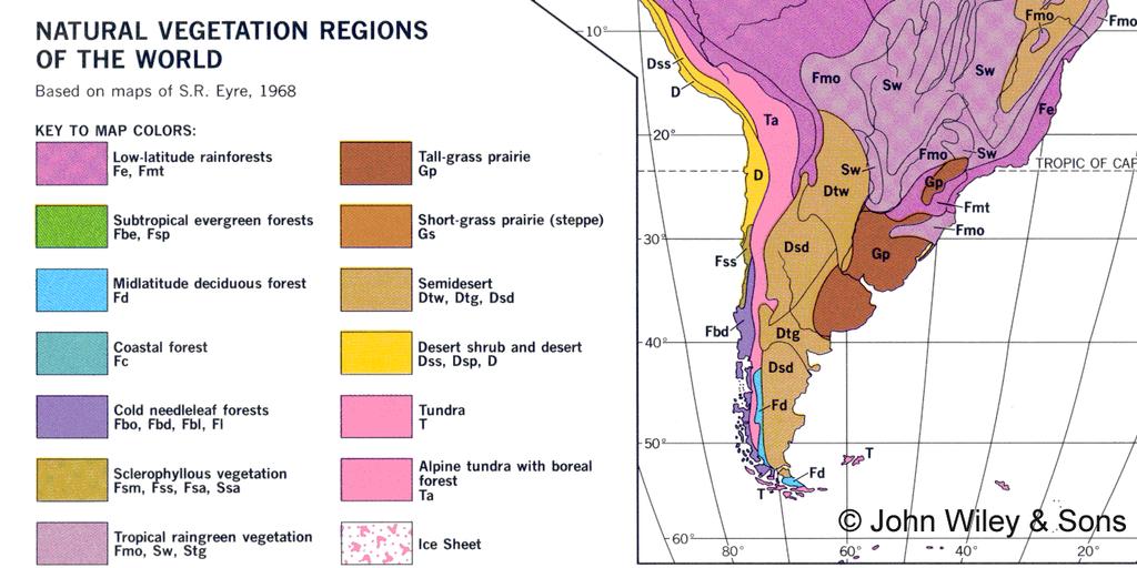
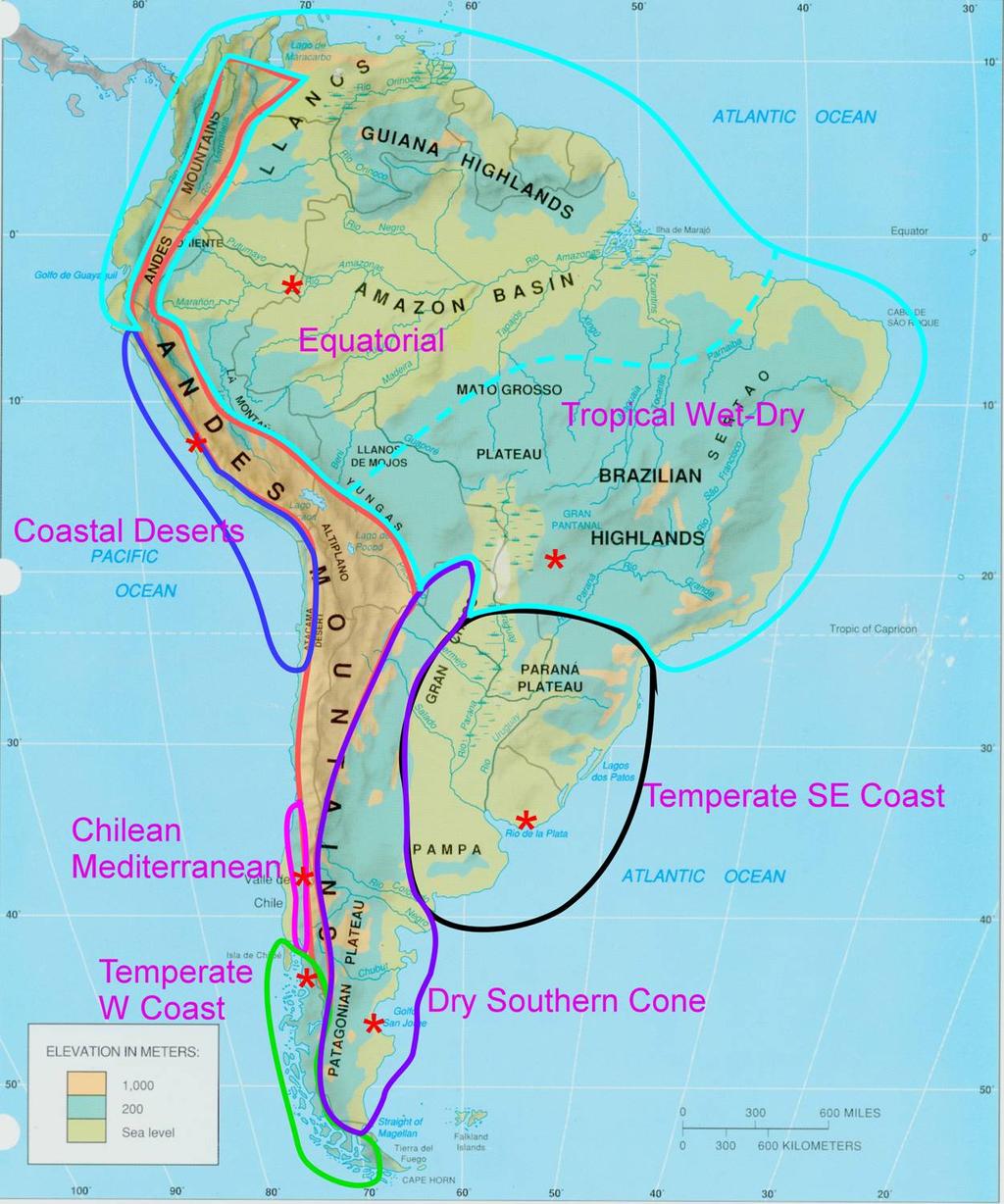
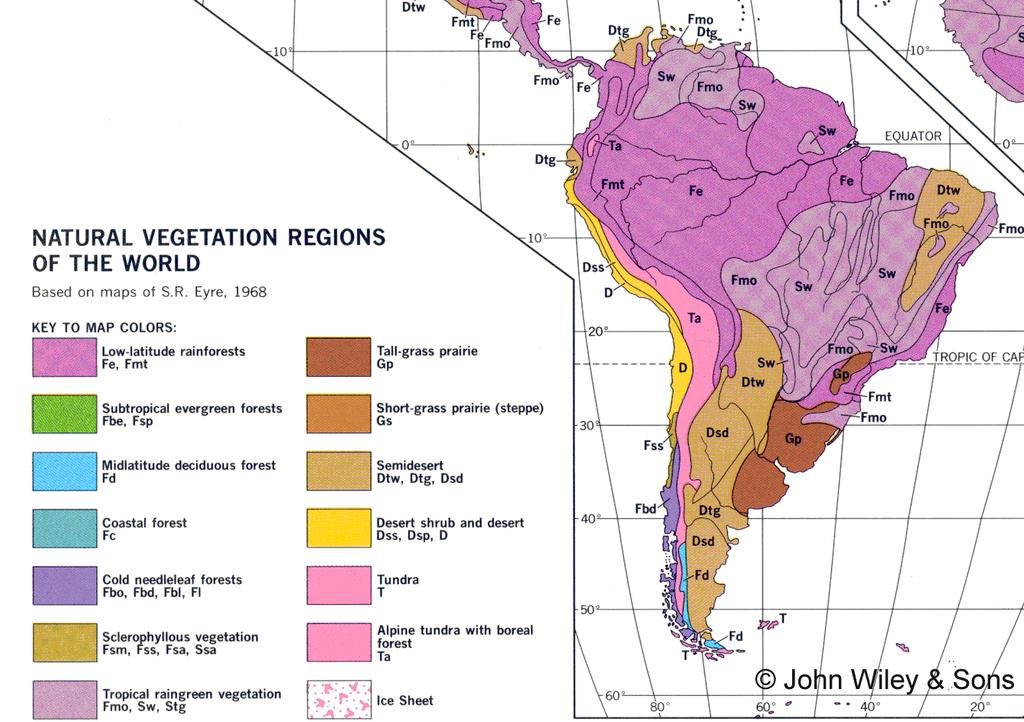
2 TODAY: Physical Geography Continued Coastal deserts of South America Andean highlands Dry & Mediterranean lands of Southern Cone Humid temperate southeastern SA Amazonia
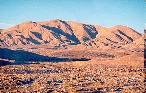
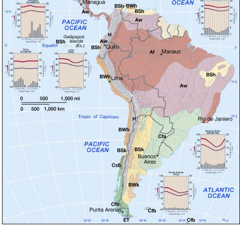
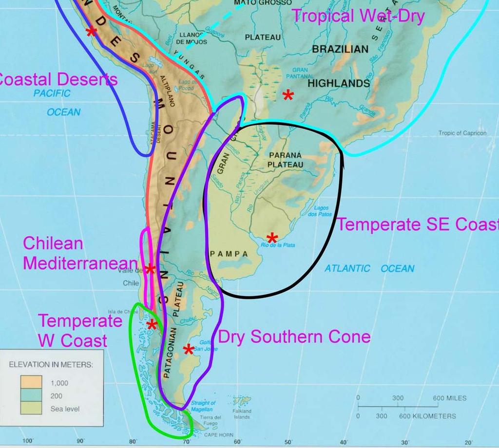
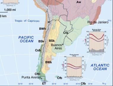
3 Coastal deserts of South America ~ 3º S in Peru to ~ 30º S in Chile Climate is the main story here Southern parts called the Atacama Unlike most of world s deserts that lie in bands ~ 30º N & S this runs from ~ 3º to 30º S
4 Coastal deserts of South America ~ 3º S in Peru to ~ 30º S in Chile Causes of aridity are complex but 2 major ones Trade winds from SE blocked by Andes Cold water coast due to S. Pacific gyre Role of global climatic phenomena called the El Niño - Southern Oscillation
5 South America
6 South America
7 Coastal deserts of South America 3º S in Peru to ~ 30º S in Chile Vegetation In places virtually none Most are xerophytic (aridity adapted) Land forms Andes near sea narrow coastal plane - more like a ledge in N wider in S Along tectonic plate edge => earthquakes
8 PLATE BOUNDARY
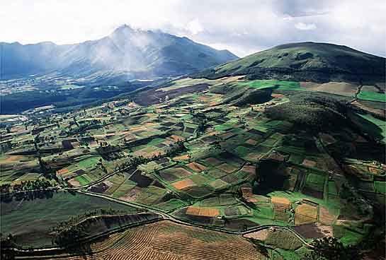
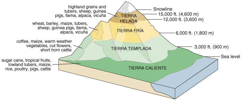
9 Andean highlands Landforms: parallel mtn chains extending from Venezuela at 10º N to S tip of S.A. (Tierra del fuego at 50º S) - many > 6,000 meters (20,000') peaks Climate: Varies with elevation! Vegetation: varies with elevation and rainfall (aspect) 2 distinctive eco-communities of note Soils: many good volcanic andisols
10 Andean highlands Landforms parallel mtn. chains extending from 10º N to 50º S Altiplano 3,000-4,000m elevation (11,000-13,000 ft) Ancient culture core of the Inka (Inca) Tectonic: a classic convergent plate boundary many > 6,000 meters (20,000') peaks Mostly volcanic with some folded mtns. Rivers Short intermittant in west Large east-flowing
11 Andean highlands: Climate Köppen H (highlands) climate Does not say much! Key here is elevation temp of 6ºC/1000m (3ºF/1000ft) Annual vs diurnal temp range Wetter N; drier center; wetter S
12 Andean highlands: Climate More complex than elevation alone Aspect Relative relief Terraces Diurnal differences
13 Andean highlands Vegetation varies with elevation and rainfall (aspect) 2 distinctive eco-communities of note: páramo (tall grasses in Ecuador and Venezuela) and puna (short grasses mostly in Peru and Bolivia) Soils many are good volcanics
14 Dry lands of the Southern Cone Patagonia leeward rain shadow; little precip (Bs or Bw); seasonal temp swing; step-like plateaux with very steep canyons and spectacular mtns; very windy Chaco and Eastern Andes piedmont sloping plains and piedmonts, grasslands with scrub
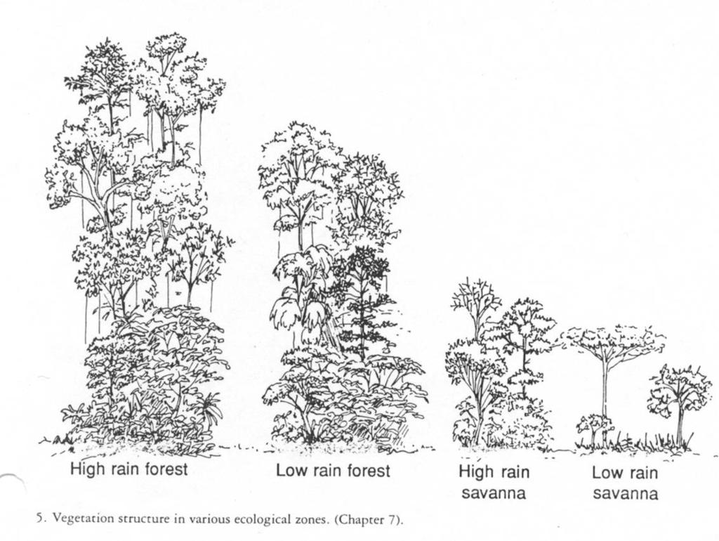
15
16 Humid temperate South America Landforms famous location of Pampas plains and low sloping uplands Climate: moderate seasonal temp swing; little seasonal precip difference Vegetation not a forest landscape but tall grasses Soils superior soils (mollisols) on Pampas with great stored natural fertility
17
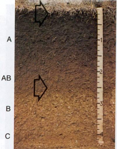
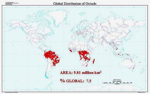
18 Mollisol
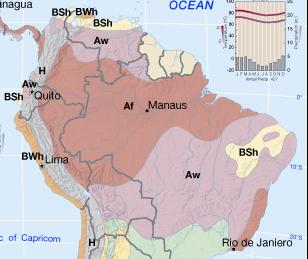
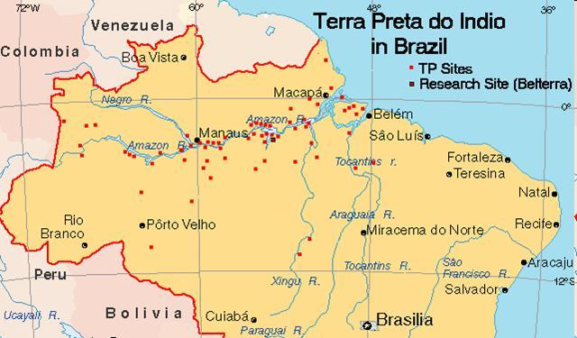
19 Amazonia & central lowland South America Landforms highlands vast low lying river basins Climates Equatorial: Af warm & wet constantly Tropical wet/dry: Aw warm with seasonal rain
20
21 Amazonia & central lowland S. Am. Wet-dry tropical vegetation: open forests & savannas Equatorial rainforests
22 Equatorial rainforests Richest terrestrial biome on earth > 1 million higher plant and animal species (10 20% of world s total); even more if micro fauna and flora and insects added Very diverse (>60 different species of large trees in 1 ha); > 600 total species/ha Diversity => relative scarcity of any particular species in any area highest total of biomass per ha on earth
23 Equatorial rainforests II Broadleaved trees in multistory canopy Rapid recycling of plant nutrients Warm temps and much rain => leaching of nutrients from soils (many of these are among the world s worst)
24 Nutrient flows in forests Solar energy
25 Amazonian Soils Terra firme soils in Amazonia ancient shield rocks Rapid nutrient recycling Called oxisols or ultisols Alluvial soils based on silt deposited along river flood plains of Amazon and its tributaries White water rivers Várzea
26 Amazonian Soils II Anthropogenic soils Raised fields Terra preta do Indio soils
27 Soils and fertility 4 major parts to soils organic matter (partly decomposed = humus) inorganic matter sand, silt, and clay moisture air
28 Soils and fertility II Major plantnutrients Solar energy from air - CO 2 From water: hydrogen (H); oxygen (O); from soils (and fertilizers): phosphorus (P); nitrogen (N); and potassium (K)
29 Soil nutrients Must be dissolved for roots to absorb Available to plants only in the form of cations (+ charge) and anions (- charge) (in solution)
30 Soil nutrients Most important nutrients are: Nitrogen (N) Potassium (K) Phosphorus (P) Plus about 10 micro-nutrients Importance of clay and humus (serve as sites to which cations and anions attach) Note role of nitrogen-fixing bacteria
31 Cation Exchange Capacity CEC Measure of ability of a soil to retain and exchange nutrient cations CEC associated with some clays and humus storage of basic cations defines fertile soils Aluminum is especially toxic and found in acidic soils
32 Quiz 1 1) Name the primary physical geographical regions of Meso/Central America and South America. 2) Name 1 climate, 1 soil, 1 vegetation, and 1 topographical feature for each of these regions.
33
34 Porter GeoConsultancy
35

36 N. Atlantic Gyre Trade winds Trade winds S. Pacific Gyre S. Atlantic Gyre
37
38
39 Ecuador

40 PLATE BOUNDARY

41 Classic Convergent Plate Collision Andes
42
43
44
45
46
47 Sarmiento ; ~ 45º 45º S S
48 40º N
49
50
 = 9 Total Annual Precipitation (mm) = 475 Summer Precipitation (mm) = 54")
51 Latitude/Longitude = o N; o W Average Annual Temperature ( o C) = Annual Temperature Range ( o C) = 9 Total Annual Precipitation (mm) = 475 Summer Precipitation (mm) = 54 Winter Precipitation (mm) = 421
52
53
54
55
56
57


58 Ultisol Oxisol (this soil is from NC)
59 Diurnal temp range ~ 15º C (~ 30º F) Annual temp range ~ 6º C
A funny sounding lake. South American Landforms, Climate, and Vegetation
 A funny sounding lake South American Landforms, Climate, and Vegetation 3 4 Essential Question: How have physical features and climate affected the population distribution of Latin America? 5 I. Landforms
The Lesser Antilles. Dominican Republic), and Puerto Rico
, and Puerto Rico") The Caribbean Islands are archipelagoes or groups of islands. The major archipelagoes are: The Greater Antilles - Cuba, Jamaica, Hispaniola (Composed of Haiti and the Dominican Republic), and Puerto Rico
The Caribbean Islands are archipelagoes or groups of islands. The major archipelagoes are: The Greater Antilles - Cuba, Jamaica, Hispaniola (Composed of Haiti and the Dominican Republic), and Puerto Rico
Latin America. Physical Geography
 Latin America Physical Geography Regions Latin America can be divided into separate regions based on physical geography or cultural geography. Regions If we look at physical geography Latin America has
STUDY GUIDE. The Land. Physical Features of Latin America. Chapter 8, Section 1. Terms to Know DRAWING FROM EXPERIENCE ORGANIZING YOUR THOUGHTS
 For use with textbook pages 193 198. The Land Terms to Know cordillera A mountain range that runs parallel to another mountain range (page 194) altiplano A high plain (page 194) escarpment A steep cliff
Friday, November 10, 2017
 Friday, November 10, 2017 Andes and Midlatitude Countries Objective: Summarize the main physical features and regions of the Southern Cone. Identify and locate the urban centers and understand the pattern
Latin America. Physical Geography
 + Latin America Physical Geography + I. Landforms A. Caribbean & Central America 1. Mexico is dominated by two mountain chains, collectively called the Sierra Madre. A high plateau is situated in between.
THE PHYSICAL AND CULTURAL GEOGRAPHY OF SOUTH AMERICA
 THE PHYSICAL AND CULTURAL GEOGRAPHY OF SOUTH AMERICA 1 Global location Relative to European capitals Relative to US cities Time zones Two oceans Pacific rim countries - farther to Asia than USA Not on
Latin America. Chapter 9 Physical Geography
 Latin America Chapter 9 Physical Geography Latin American Regions Middle America includes Mexico and the Central American countries The Caribbean Islands South America Mexico Landforms Sierra Madre Oriental
Objective. Students will familiarize themselves with the physical features and climates of Latin America.
 Journal Write KWL What do you KNOW about Latin America? What do you WANT TO KNOW about Latin America? What did you LEARN today that you didn t know before? Latin America Objective Students will familiarize
South American Countries. Capital Location Population Terrain Climate
 South American Countries Capital Location Population Terrain Climate Andes Mountains Four large areas that make up the Central Plains: Llanos, the Selva, the Gran Chaco, and the Pampas Brazilian Highlands
Latin America. Introduction
 Latin America Introduction What are the 5 Themes of Geography? Draw lines to connect the theme to the definition: Location How humans and the environment impact each other Physical and human characteristics
World Geography Ch. 7.2 Climate Regions of Latin America
 World Geography Ch. 7.2 Climate Regions of Latin America BR: D10 When you think of Latin America, what types of climates do you think are down there? Write down which of the following you believe are there:
Latin America s Physical Geography. EQ: What are characteristics of Latin America s physical features?
 Latin America s Physical Geography EQ: What are characteristics of Latin America s physical features? Your Task: We are going to participate in a Museum Walk! You will travel around the room with a partner
CHAPTER 12. South America. Section 1: Natural Environments Section 2: History and Culture Section 3: South America Today. HOLT World Geography
 CHAPTER 12 South America Section 1: Natural Environments Section 2: History and Culture Section 3: South America 1 Section 1 Natural Environments Objectives: What are the major landforms and rivers of
Regional Atlas: Introduction to Latin America
 Chapter 9, Section World Geography Chapter 9 Regional Atlas: Introduction to Latin America Copyright 2003 by Pearson Education, Inc., publishing as Prentice Hall, Upper Saddle River, NJ. All rights reserved.
South America: Physical Geography
 This website would like to remind you: Your browser (Apple Safari 4) is out of date. Update your browser for more security, comfort and the best experience on this site. Encyclopedic Entry South America:
Essential Questions. 1. How have historical figures and events affected South America today?
 South America Essential Questions 1. How have historical figures and events affected South America today? 2. How has location affected the development of countries in South America? 3. How has the role
Geographic Qualities of South America
 Geographic Qualities of South America 1. South America is the fourth largest continent in area. It is located in the Western Hemisphere, lying southwest of North America. Most of South America lies in
What Is An Ecoregion?
 Ecoregions of Texas What Is An Ecoregion? Ecoregion a major ecosystem with distinctive geography, characteristic plants and animals, and ecosystems that receives uniform solar radiation and moisture Sometimes
Mrs. Reifsnyder World Geography. Unit 8: Latin America Study Guide SOLs Addressed: WG. 1c, 2b, 3c, 4, 10b/c
 Mrs. Reifsnyder World Geography Unit 8: Latin America Study Guide SOLs Addressed: WG. 1c, 2b, 3c, 4, 10b/c Essential Questions: - In what ways do physical, economic, and cultural characteristics influence
South America. pg. 520 (5 th) pg. 523 (6 th )
 pg. 523 (6 th )") South America pg. 520 (5 th) pg. 523 (6 th ) Venezuela Rich in Oil Lake Maracaibo Called Little Venice pg. 572 (5 th) pg. 574 (6 th ) Caracas 8 miles Inland 3000 pg. 572 (5 th) pg. 574 (6 th ) Caracas
South America pg. 520 (5 th) pg. 523 (6 th ) Venezuela Rich in Oil Lake Maracaibo Called Little Venice pg. 572 (5 th) pg. 574 (6 th ) Caracas 8 miles Inland 3000 pg. 572 (5 th) pg. 574 (6 th ) Caracas
*Latin America spans 7,000 miles, from Mexico to Tierra Del Fuego. *3 Regions: Central America, South America, and the Caribbean.
 Physical Geography Latin America spans 7,000 miles, from Mexico to Tierra Del Fuego *3 Regions: Central America, South America, and the Caribbean. *Intro clip: http://www.youtube.com/watch?v=cffp6rza3
2.1 What is the climate like?
 José Medeiros This fact sheet allows you to see how varied the countryside is across Brazil. 2.1 What is the climate like? Most of Brazil is in the Southern Hemisphere, where the seasons are the opposite
CHAPTER Latin America. Regional Atlas Study Guide. 2 Chapter A. As You Read. B. Reviewing Vocabulary
 CHAPTER 28 9 Many Th ew inventions new Regional Atlas Study Guide Latin America Directions: As you work through the Regional Atlas, complete the chart below by writing two details about each Latin American
EXPLORING BIOMES IN GORONGOSA NATIONAL PARK
 EXPLORING BIOMES IN GORONGOSA NATIONAL PARK ABOUT THIS WORKSHEET This worksheet complements the Click and Learn Gorongosa National Park Interactive Map (http://www.hhmi.org/biointeractive/gorongosa-national-park-interactive-map),
Region 1 Piney Woods
 Region 1 Piney Woods Piney Woods 1. This ecoregion is found in East Texas. 2. Climate: average annual rainfall of 36 to 50 inches is fairly uniformly distributed throughout the year, and humidity and temperatures
The Geography of Climate
 The Geography of Climate Objective for Today: Today we will examine ways that latitude and landforms influence climate The focus of our study will be the South American Continent in the Formal Region known
UNIT 5 AFRICA PHYSICAL GEOGRAPHY SG 1 - PART II
 UNIT 5 AFRICA PHYSICAL GEOGRAPHY SG 1 - PART II III. CLIMATE & VEGETATION A. The four main climate zones are tropical wet, tropical wet/dry (split into monsoon & savanna), semiarid, and arid. Other climate
Chapter 19 Test on South America
 Name Part 1 - Labeling (27 pts.) Chapter 19 Test on South America Score A. Locate the countries and territory contained in the word box below on the map of South America on the next page. Write the name
Chapter 20. The Physical Geography of Africa South of the Sahara
 Chapter 20 The Physical Geography of Africa South of the Sahara Chapter Objectives Identify the major landforms, water systems, and natural resources of Africa south of the Sahara. Describe the relationship
Chapter 13: Life in the Central Andes- Adapting to a Mountainous Region
 Chapter 13: Life in the Central Andes- Adapting to a Mountainous Region 1. Introduction La Paz, Bolivia, is the highest big city in the world, sitting at 12,000 feet above sea level in the central Andes
Just how big is Africa?
 The United States China India The United Kingdom Portugal Spain France Belgium Germany The Netherlands Switzerland Italy Eastern Europe Japan 11.7 million sq. miles Just how big is Africa? Chapter 18 Section
Mrs. Davis s Adventures
 Mrs. Davis s Adventures Latin America Countries & Political Map NAME: DATE: PERIOD: DIRECTIONS: Use your mapping skills and textbook pages: 127, 97, and 3 to complete Mrs. Davis s Story. Transfer the countries
Exploring South America Learning Lapbook with Study Guide
 A J T L Grades 1-4 Exploring South America Learning Lapbook with Study Guide A Journey Through Learning www.ajourneythroughlearning.com Copyright 2013 A Journey Through Learning 1 Authors-Paula Winget
STUDY GUIDE. The Land. Chapter 29, Section 1. Both. Terms to Know DRAWING FROM EXPERIENCE ORGANIZING YOUR THOUGHTS
 Chapter 29, Section 1 For use with textbook pages 719 724. The Land Terms to Know cordilleras Parallel mountain ranges and plateaus (page 719) archipelago A group of islands (page 720) insular Relating
THE ANDEAN AREA....How does the rich countries development affect some poor and 1. distant countries
 THE ANDEAN AREA...How does the rich countries development affect some poor and 1 distant countries 1. Geographical situation of the Andean area South America view 2 Andes mountain range Amazonian basin
STUDY GUIDE. The Land. Chapter 20, Section 1. The Land of Africa South of the Sahara. Landforms Water Systems Natural Resources.
 For use with textbook pages 499 504. The Land Terms to Know escarpment A steep, often jagged slope or cliff (page 500) cataract A towering waterfall (page 500) rift valley A large crack in the earth s
Latin America and The Caribbean. A Closer Look.
 Latin America and The Caribbean A Closer Look. Mexico Capital: Mexico City The Location of Mexico Mexico is the second-largest country by size and population in Latin America.but the Largest Spanish -
AFRICAN PHYSICAL GEOGRAPHY
 AFRICAN PHYSICAL GEOGRAPHY Here are some factoids about Africa: world s second largest continent (11,700,000 miles). Home to 52 countries, 1,000 languages, 800 million people. 10% of the world s population
Chapter Objectives. Describe the dominant landforms and natural resources of Southeast Asia. Discuss Southeast Asia s climate and vegetation.
 Chapter Objectives Describe the dominant landforms and natural resources of Southeast Asia. Discuss Southeast Asia s climate and vegetation. The Land Section 1 Objectives Describe how tectonic plates and
WORLD GEOGRAPHY. Hector Rodriguez
 Mr. Chavira 9th Period WORLD GEOGRAPHY Hector Rodriguez P a g e 1 Table of Contents Latin America Page 2 o Maps Economic Map Page 3 Political Map Page 4 Population Map Page 5 Physical Page 6 o Notes Physical
CRI Loreto. IIAP crew seining for Colossoma macropomum broodstock at the CRI Loreto research site in Peru.
 PERU CRI Loreto 43 PD/A CRSP SITE DESCRIPTIONS CRI Loreto Marcos J. De Jesús Marcos J. De Jesús IIAP crew seining for Colossoma macropomum broodstock at the CRI Loreto research site in Peru. Hatchery facilities
The Geological Pacific Northwest. Wednesday February 6, 2012 Pacific Northwest History Mr. Rice
 The Geological Pacific Northwest Wednesday February 6, 2012 Pacific Northwest History Mr. Rice 1 Free Response #2 Please do not simply list the items for this response. Full sentences!!! Minimum of 3-5
Portuguese Language - Fostering National Unity
 Geography Brazil Brazil Portuguese Language - Fostering National Unity 11 dialects of Portuguese Influenced by Amerindian and African languages, creating differences between Portuguese spoken in Brazil
Why is the US industry and agriculture prosperous? The US industry and agriculture is so prosperous because it has many different natural resources.
 Ch. 1-7 Study Guide Why is the US industry and agriculture prosperous? The US industry and agriculture is so prosperous because it has many different natural resources. What likely drew immigrants to the
UNIT 3 Extra Review for Chapters 9-11
 UNIT 3 Extra Review for Chapters 9-11 Mexico Central America Caribbean Islands Middle America is Central America, Mexico, and the Islands of the Caribbean Central America is a region within Middle America.
Hydrology of Yemen. Dr. Abdulla Noaman
 Hydrology of Yemen Dr. Abdulla Noaman INTRODUCTION Location and General Topography Yemen is located on the south of the Arabian Peninsula, between latitude 12 and 20 north and longitude 41 and 54east,
1st Period Mr. Chavira WORLD GEOGRAPHY. Hector Rodriguez
 1st Period Mr. Chavira WORLD GEOGRAPHY Hector Rodriguez P a g e 1 Table of Contents Latin America Page 2 o Maps Economic Map Page 3 Political Map Page 4 Population Map Page 5 Physical Page 6 o Notes Physical
GEOGRAPHY OF THE WESTERN HEMISPHERE
 GEOGRAPHY OF THE WESTERN HEMISPHERE LEARNING LOG Write clear directions that describe how to get from one place to another. Choose 2 locations that other people might not know about. Did you use a map
Comprehension Questions:
 Unit 3: Central & South america Comprehension Questions: 1. What is the driest desert on earth? Atacama Desert 2. What two water routes were discovered in the 1500s to get around the tip of South America?
Chapter 17. North Africa, Southwest Asia and Central Asia
 Chapter 17 North Africa, Southwest Asia and Central Asia Chapter Objectives Describe the major landforms and natural resources of North Africa, Southwest Asia, and Central Asia. Discuss the climate and
Public Works Research Institute
 Public Works Research Institute INTERNATIONAL WORKSHOP ON WATER HAZARD AND RISK MANAGEMENT SOME EXPERIENCES OF FLOOD MANAGEMENT IN ARGENTINA VÍCTOR POCHAT National Director for Water Policies,Coordination
SS7G1 The student will locate selected features of Africa.
 Standards SS7G1 The student will locate selected features of Africa. a. Locate on a world and regional political-physical map: the Sahara, Sahel, savanna, tropical rain forest, Congo River, Niger River,
The Geography Of Ecuador Essay
 The Geography Of Ecuador Essay We can write The Geography Of Ecuador. We provides students with professionally written essays, research papers, term papers, reviews, theses, dissertations and more. Once
Lecture #1: Introduction
 Anthropology G4210 The Rise of Andean Civilization T. D'Altroy September 8, 1999 Lecture #1: Introduction 1. purposes of the course a. examination of the nature and development of societies in the Andes
GEOGRAPHY AND HISTORY
 GEOGRAPHY AND HISTORY YEAR 1, PART 1 www.vicensvives.es Contents 01 Our planet Earth 02 The representation of the Earth: maps 03 The Earth s relief 04 Rivers and seas 05 Weather and climate 06 Climates
LOCATION, CLIMATE, AND NATURAL RESOURCES OF MEXICO
 SS6G3 The student will explain the impact of location, climate, distribution of natural resources, and population distribution on Latin America and the Caribbean. a. Compare how the location, climate,
ANDEX: A Regional Hydrology Program for the Andes
 ANDEX: A Regional Hydrology Program for the Andes Silvina Solman CIMA (CONICET-UBA) - Universidad de Buenos Aires Argentina Germán Poveda Universidad Nacional de Colombia, Medellín Colombia TPE-GHP/GEWEX
Water in the Amazon. By Heather and Georgie
 Water in the Amazon By Heather and Georgie The Amazon is the world s largest tropical rainforest. The Amazon is so big that the U.K and Ireland would fit into it 17 times. The Amazon River It s length
1. Summarize the main physical features and regions of the Southern Cone.
 6.4 The Southern Cone L E A R N I N G O B J E C T I V E S 1. Summarize the main physical features and regions of the Southern Cone. 2. Identify and locate the urban centers and understand the pattern of
Chapter 12. Other Tropical Ecosystems: From the Mountains to the Rivers to the Sea
 Chapter 12 Other Tropical Ecosystems: From the Mountains to the Rivers to the Sea FIGURE 12-1 Vegetation belts in the Cordillera Oriental (Colombia) shown schematically. PowerPoint Tips (Refer to the Microsoft
Africa s. Presentation, Graphic Organizers, & Activities
 Africa s Presentation, Graphic Organizers, & Activities STANDARDS: SS7G1 Locate selected features of Africa. a. Locate on a world and regional political-physical map: Sahara, Sahel, savanna, tropical rain
Monday, December 11, 2017
 Monday, December 11, 2017 Physical Geography of Russia Objective: complete Warm-Up, write outline notes and discuss the geography of Eastern Europe/mother Russia and view Geography Now: Belarus. География
COPYRIGHTED MATERIAL [1] L ANDS AND CLIMATES
![COPYRIGHTED MATERIAL [1] L ANDS AND CLIMATES](/thumbs/81/82837436.jpg "COPYRIGHTED MATERIAL [1] L ANDS AND CLIMATES") [1] L ANDS AND CLIMATES B ROADLY considered, Latin America s geography is not friendly to human occupation, or favorable to people s activities. The struggle to live and thrive on the land has produced
[1] L ANDS AND CLIMATES B ROADLY considered, Latin America s geography is not friendly to human occupation, or favorable to people s activities. The struggle to live and thrive on the land has produced
6th Grade Western Hemisphere Geography
 6th Grade Western Hemisphere Geography Multiple Choice Identify the choice that best completes the statement or answers the question. 1 Latin America is located in the A Northern Hemisphere. C Western
Name: Hour: Day: The Land and Its Regions (pg ) Define, in your own words, escarpment. Define, in your own words, sertão
 Define, in your own words, escarpment. Define, in your own words, sertão") Name: Hour: Day: World Geography Guided Reading Notes Chap 12 & 13 --- ANSWER IN COMPLETE SENTENCES!!!! READ EACH QUESTION CAREFULLY & ANSWER COMPLETELY!!!! Objectives: Upon completion of reading you should
Name: Hour: Day: World Geography Guided Reading Notes Chap 12 & 13 --- ANSWER IN COMPLETE SENTENCES!!!! READ EACH QUESTION CAREFULLY & ANSWER COMPLETELY!!!! Objectives: Upon completion of reading you should
Chapter 7 Geography and the Early Settlement of Egypt, Kush, and Canaan
 Chapter 7 Geography and the Early Settlement of Egypt, Kush, and Canaan How did geography affect early settlement in Egypt, Kush, and Canaan? Section 7.1 - Introduction RF/NASA//Corbis This satellite photograph
STUDY GUIDE. The Land. Chapter 17, Section 1. There are frequent earthquakes in the region. Petroleum is a major export in the region.
 For use with textbook pages 421 426. The Land Terms to Know alluvial soil A rich soil made up of sand and mud deposited by flowing water (page 423) wadi A streambed that remains dry until a heavy rain
Brain Wrinkles. Location, Climate, & Natural Resources of. Where People Live & How They Trade
 Location, Climate, & Natural Resources of Where People Live & How They Trade It s south of the US, east of the Pacific Ocean, and west of the Gulf of Mexico & Caribbean Sea. It s great that it s located
Chapter 14. The Physical Geography of Russia
 Chapter 14 The Physical Geography of Russia Chapter Objectives Identify the physical features and natural resources of Russia. Discuss the effects of Russia s climate and vegetation on life in the region.
PHILIPPINES FAC. Iloilo
 PHILIPPINES FAC Iloilo 55 PD/A CRSP SITE DESCRIPTIONS FAC The FAC has over 100 earthen ponds, some up to 2,500 m 2. CLSUs College of Fisheries shares FACs technical staff, facilities, and research responsibilities
Brain Wrinkles. Africa: The impact of location, climate, & physical characteristics on where people live, the type of work they do, & how they travel
 Africa: The impact of location, climate, & physical characteristics on where people live, the type of work they do, & how they travel STANDARDS: SS7G3 The student will explain the impact of location, climate,
Geography: Latin America (ch. 8, 9 and 10) page 1. p. 178: What areas make up Latin America? Mexico, Central Amer., Caribbean Islands, South America
 page 1. p. 178: What areas make up Latin America? Mexico, Central Amer., Caribbean Islands, South America") Geography: Latin America (ch. 8, 9 and 10) page 1 p. 178: What areas make up Latin America? Mexico, Central Amer., Caribbean Islands, South America Chapter 8: Physical Geography of Latin America I. The
Geography: Latin America (ch. 8, 9 and 10) page 1 p. 178: What areas make up Latin America? Mexico, Central Amer., Caribbean Islands, South America Chapter 8: Physical Geography of Latin America I. The
Brazil Today The Amazon River and Basin
 Non-fiction: Brazil Today The Amazon River and Basin Brazil Today The Amazon River and Basin Deep within the Andes Mountains of northern Peru, two rivers flow together. Their junction forms one of the
STANDARDS: Brain Wrinkles
 STANDARDS: SS6G3 The student will explain the impact of location, climate, distribution of natural resources, and population distribution on Latin America and the Caribbean. a. Compare how the location,
Chapter 10 Study Guide SOUTH AMERICA
 Chapter 10 Study Guide SOUTH AMERICA When Spain and Portugal competed for trading lands in the New World, who came up with the line of demarcation to settle the dispute? The Caribbean Countries: Who was
early human history and Central & South America Jeopardy
 early human history and Central & South America Jeopardy Every team will be chosen by Joe with the intention of mixing girls and boys and grade levels. Teams can choose a name if desired. teams can answer
Terms to Know. artesian well coral atoll krill lagoon
 Chapter Objectives Describe the diverse landforms and natural resources of Australia, Oceania, and Antarctica. Discuss the wide range of climates and vegetation throughout the region. The Land Section
There are actually six geographic sub-regions, three in both the uplands and the lowlands.
 6 Regions of AR Although Arkansas is most easily divided into two distinct geographical regions, the northwestern uplands and the southeastern lowlands, this description does not accurately portray the
Table of Contents. Argentina Brazil Chile Cuba Nicaragua Panama Peru In Your Classroom...
 Table of Contents Argentina... 4 Brazil... 25 Chile... 48 Cuba... 68 Nicaragua... 89 Panama... 109 Peru... 127 In Your Classroom... 148 Answer Key... 152 Additional Resources... 155 MP5129 3 Mts. Argentina
LATIN AMERICA. Mexico Central America Caribbean Islands South America
 LATIN AMERICA Mexico Central America Caribbean Islands South America HISTORY First Settlers Hunters/gatherers from Asia crossed land bridge connecting Asia and Alaska Learned to farm over time Maize (corn)
EXPLORING EARTH S SURFACE. Lesson 4
 EXPLORING EARTH S SURFACE Lesson 4 Introduction Lewis and Clark In 1804, an expedition set out from near Saint Louis to explore the land between the Mississippi River and the Pacific Ocean, The United
3 rd Term Worksheet [ ] Subject Geography Class VI Name : Sec. :
![3 rd Term Worksheet [ ] Subject Geography Class VI Name : Sec. :](/thumbs/84/89736232.jpg "3 rd Term Worksheet [ ] Subject Geography Class VI Name : Sec. :") 1 geo (vi) 3 rd Term Worksheet [2018 19] Subject Geography Class VI Name : Sec. : Case Study 1 : The Lumberjacks of Canada Exercise: [80-81] [A] Choose the correct answers: [80] 1. What are the men who
1 geo (vi) 3 rd Term Worksheet [2018 19] Subject Geography Class VI Name : Sec. : Case Study 1 : The Lumberjacks of Canada Exercise: [80-81] [A] Choose the correct answers: [80] 1. What are the men who
CH. 1 Europe and Russia: Physical Geography. Section 1 Land and Water p Europe and Russia are part of the world s largest landmass called.
 CH. 1 Europe and Russia: Physical Geography Section 1 Land and Water p.10-16 Europe and Russia are part of the world s largest landmass called. The country of Russia stretches over both continents. About
Latin America: Physical Geography
 Page 1 of 7 Latin America: Physical Geography TERMS & NAMES tributary deforestation Tropical Zone El Niño MAIN IDEA Latin America s landforms, bodies of water, and climate offer a wide range of environments
UNIT 5 PHYSICAL GEOGRAPHY SG 1 - PART I
 UNIT 5 PHYSICAL GEOGRAPHY SG 1 - PART I Africa is HUGE! I. LANDFORMS A. Plateaus - an area of relatively level high ground. 1. Africa s interior is dominated by series of plateaus and elevated basins such
2018 Spring Semester Final : STUDY GUIDE
 Name: Hr: 2018 Spring Semester Final : STUDY GUIDE My final is on:, May My final will have questions and will be COLONIZATION OF NORTH & SOUTH AMERICA - Match the regions with the European countries that
6th Grade Western Hemisphere Geography
 6th Grade Western Hemisphere Geography Multiple Choice Identify the choice that best completes the statement or answers the question. 1 Latin America is located in the A Northern Hemisphere. C Western
Physical Regions of the U.S.
 Physical Regions of the U.S. Quickly use this map to label the map on your paper Pacific Coast The coast from southern California to Alaska The region of the Pacific Northwest has a long history that was
Month June 2011 South America (except Colombia for HA) Date of submission 01/07/11 MONTHLY REPORT
 Date of submission 01/07/11 MONTHLY REPORT") ANNEX IV-3 EUROPEAN COMMISSION HUMANITARIAN AID OFFICE (ECHO) Monthly report number 2011/6 Month June 2011 Country South America (except Colombia for HA) Date of submission 01/07/11 Author ECHO Quito MONTHLY
ANNEX IV-3 EUROPEAN COMMISSION HUMANITARIAN AID OFFICE (ECHO) Monthly report number 2011/6 Month June 2011 Country South America (except Colombia for HA) Date of submission 01/07/11 Author ECHO Quito MONTHLY
2015 Brain Wrinkles. SS8G1b
 SS8G1b Georgia is a geographically diverse state that is divided into five regions. The first three regions (Appalachian Plateau, Valley and Ridge, and Blue Ridge) are in the mountains and foothills of
South America. Land of Color and Contrast
 South America Land of Color and Contrast Home to: *The world s largest river system *The longest mountain chain, and second tallest mountains *Earth s driest desert *One of the world s great grassland
2012. Proceedings of the 11 European Geoparks Conference. AGA Associação Geoparque Arouca, Arouca, 5-6.
 References to this volume It is suggested that either the following alternatives should be used for future bibliographic references to the whole or part this volume: th Sá, A.A., Rocha, D., Paz, A. & Correia,
Location, Climate, & Natural Resources
 Location, Climate, & Natural Resources UK is a country of islands off the coast of mainland Europe. It consists of England, Northern Ireland, Scotland, & Wales. UK s location makes it a HUB for trade.
Introduction. We hope you find these materials useful and would welcome any feedback.
 Introduction This planning pack was produced with teachers from County Durham following a visit to São Paulo. The materials support the teaching of geography at key stage one and two within the context
Location, Climate, & Natural Resources Brain Wrinkles
 Location, Climate, & Natural Resources Standards SS6G10 The student will explain the impact of location, climate, natural resources, and population distribution on Europe. a. Compare how the location,
Pack Your Geography Terms for a Trip With Maggie and Friends!
 Maggie s Weekly Activity Pack! Name Date Pack Your Geography Terms for a Trip With Maggie and Friends! Do you know where the continents are on the Earth? Are you able to tell which countries are on which
Africa: Physical geography
 Africa: Physical geography By National Geographic Society, adapted by Newsela staff on 09.15.17 Word Count 1,279 Level 1040L African elephants roam the savannas, which cover almost half of the African
Oceania. Australia, New Zealand, and the Pacific Islands. Physical Geography. Where is Australia located?
 Oceania Australia, New Zealand, and the Pacific Islands Physical Geography Australia New Zealand Oceania Where is Australia located? Australia & Oceania are a group of islands located between Asia, Antarctica,
Chapter 7. Geography and the Early Settlement of Egypt, Kush, and Canaan
 Chapter 7 Geography and the Early Settlement of Egypt, Kush, and Canaan Chapter 7 Geography and the Early Settlement of Egypt, Kush, and Canaan How did geography affect early in Egypt Kush, and Canaan?