Monday, December 11, 2017
|
|
|
- Dennis Bridges
- 5 years ago
- Views:
Transcription

1 Monday, December 11, 2017 Physical Geography of Russia Objective: complete Warm-Up, write outline notes and discuss the geography of Eastern Europe/mother Russia and view Geography Now: Belarus. География КОЗОЧКИ!!! Do Now: What is the capital of Belarus? Ukraine? What is the Orange Revolution? Volga River- is the longest river in Europe. It flows through central Russia and is widely viewed as the national river of Russia. Chernozem- a fertile black soil rich in humus, with a lighter lime-rich layer beneath. Such soils typically occur in temperate grasslands such as the Russian steppes and North American prairies.
2 Interactive #1


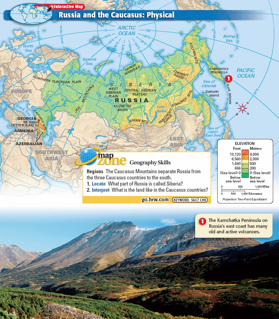
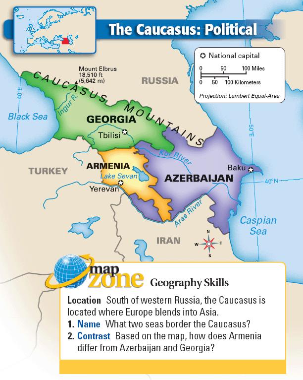
3 Physical Geography of Eastern Europe + Russian Core Landforms Russia has two notable mountain ranges, the Ural Mountains and the Caucasus Mountains. The Ural Mountains form a natural barrier between European Russia and Siberian Russia. Rich in iron ore and mineral fuels, they run in a north-to-south direction and span 1,230 miles from the Arctic Ocean almost to the Caspian Sea. The Caucasus Mountains run east to west along the southwestern portion of the country, forming a natural barrier between Russia and countries to the south. The highest peak of the Caucasus Mountains is Mount Elbrus, which soars to 18,510 feet. It is the highest mountain in Russia and Europe.


4 Physical Geography of Eastern Europe + Russian Core Landforms Pt. 2 To the west of the Ural Mountains is the Northern European Plain. The southern part of the plain has navigable waterways and rich, black soil called chernozem that supports agriculture. As a result, the majority of Russia s population lives here. East of the Ural Mountains and extending to the Pacific Ocean are the vast stretches of plains and plateaus that make up much of Siberia. The West Siberian Plain covers about one-third of Siberia and is one of the largest low-lying flatlands in the world. It is known for its harsh continental climate and some of the world s largest swamps and wetlands.

. It is also the deepest at 5,715 feet. It holds one-fifth of all unfrozen freshwater found on the planet.")
5 Physical Geography of the Eastern Europe + Russian Core Water Systems The (Tia) Volga River and its many tributaries make up the Volga River system. Draining most of western Russia, the Volga travels 2,293 miles, making it the longest river in Europe. The Volga River system is an important commercial, transportation, and hydroelectric resource for millions of Russians. One of the most renowned Siberian lakes is Lake Baikal. Located in southeast Russia, Lake Baikal is the oldest lake in the world (25 million years). It is also the deepest at 5,715 feet. It holds one-fifth of all unfrozen freshwater found on the planet. Known as the Galapagos of Russia because of its age and isolation, Lake Baikal has many unusual freshwater marine species, which are of exceptional value to scientists who study how species evolve.
6 Interactive #2

.")
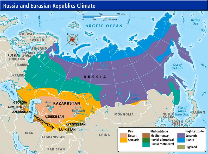
7 Physical Geography of Eastern Europe + Russian Core Climate, Biomes, and Resources The tundra occupies the parts of the subregion that are farthest north and covers about 10 percent of Russia. Here, the sky stays dark for many weeks before and after the winter solstice that occurs around December 22 each year. South of the tundra lies the subarctic climate zone. While not as severe as the tundra climate, this zone only has four months of the year when the temperature rises above 50 F (10 C). As a result, much of the country s interior has more extreme variations in temperature and little precipitation. This climatic effect within the interior areas of a landmass is called continentality.


8 Physical Geography of Eastern Europe + Russian Core Climate, Biomes, and Resources Pt. 2 Russia s physical geography benefits but also challenges its people. The country has an abundance of natural resources, including one-fifth of the world s forests. Much of this wealth, however, lies in remote and climatically unfavorable areas and is difficult to tap or utilize. For example, Russia holds large petroleum deposits and 16 percent of the world s coal reserves; however, the country s biggest coalfields lie in remote areas of eastern Siberia. Russia is also a leading producer of natural gas, but much of it is located in northern Siberia. It also leads the world in nickel production and ranks among the top three producers of aluminum, gemstones, and platinum-group metals.
9 Interactive #
10 Interactive #
11 Interactive #
Chapter 14. The Physical Geography of Russia
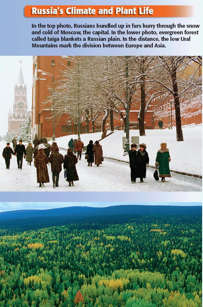
 Chapter 14 The Physical Geography of Russia Chapter Objectives Identify the physical features and natural resources of Russia. Discuss the effects of Russia s climate and vegetation on life in the region.
Label your Map with Russia. Map Activity
 Bell Activity How many time zones does the U.S. have? How do these time zones affect life in the U.S.? Russia is so large it has 11 time zones. What difficulties might this create? Objectives Know landforms,
CH. 1 Europe and Russia: Physical Geography. Section 1 Land and Water p Europe and Russia are part of the world s largest landmass called.
 CH. 1 Europe and Russia: Physical Geography Section 1 Land and Water p.10-16 Europe and Russia are part of the world s largest landmass called. The country of Russia stretches over both continents. About
Chapter 15: RUSSIA & The REPUBLICS
 Chapter 15: RUSSIA & The REPUBLICS Ch. 15:1 Landforms & Resources The Northern European Plain stretches for over 1,000 miles between the western border of Russia & the Republics and the. Ural Mountains
Location, Climate, & Natural Resources
 Location, Climate, & Natural Resources UK is a country of islands off the coast of mainland Europe. It consists of England, Northern Ireland, Scotland, & Wales. UK s location makes it a HUB for trade.
Location, Climate, & Natural Resources Brain Wrinkles
 Location, Climate, & Natural Resources Standards SS6G10 The student will explain the impact of location, climate, natural resources, and population distribution on Europe. a. Compare how the location,
Chapter 2A: The Russian Realm
 Geography: Realms, Regions, and Concepts 16 th Edition Chapter 2A: The Russian Realm The Russian Realm Two transition zones mark the margins. The Russian Realm Two transition zones mark the margins. Physical
Terms to Know. artesian well coral atoll krill lagoon
 Chapter Objectives Describe the diverse landforms and natural resources of Australia, Oceania, and Antarctica. Discuss the wide range of climates and vegetation throughout the region. The Land Section
Chapter 21: EAST AFRICA
 Chapter 21: EAST AFRICA Physical Geography of East Africa Landforms East Africa is a diverse landscape of different plains, volcanic mountains, and plateaus cut by a large valley and marked by many rivers
Chapter 13 Eastern Europe & Western Russia: Recovering from war, communism, genocide, and unfortunate geography (Pg )
") Chapter 13 Eastern Europe & Western Russia: Recovering from war, communism, genocide, and unfortunate geography (Pg. 393-420) Lesson 1: Physical Geography of Eastern Europe & Western Russia Pg. 396-401
Chapter 13 Eastern Europe & Western Russia: Recovering from war, communism, genocide, and unfortunate geography (Pg. 393-420) Lesson 1: Physical Geography of Eastern Europe & Western Russia Pg. 396-401
Europe. World Geography
 Europe World Geography Physical Geography Europe s landforms also include large plains and mountain ranges. Europe is composed of many peninsulas and islands. Always near Water Europe is a large peninsula
Chapter 20. The Physical Geography of Africa South of the Sahara
 Chapter 20 The Physical Geography of Africa South of the Sahara Chapter Objectives Identify the major landforms, water systems, and natural resources of Africa south of the Sahara. Describe the relationship
Latin America. Chapter 9 Physical Geography
 Latin America Chapter 9 Physical Geography Latin American Regions Middle America includes Mexico and the Central American countries The Caribbean Islands South America Mexico Landforms Sierra Madre Oriental
Friday, November 10, 2017
 Friday, November 10, 2017 Andes and Midlatitude Countries Objective: Summarize the main physical features and regions of the Southern Cone. Identify and locate the urban centers and understand the pattern
The Lesser Antilles. Dominican Republic), and Puerto Rico
, and Puerto Rico") The Caribbean Islands are archipelagoes or groups of islands. The major archipelagoes are: The Greater Antilles - Cuba, Jamaica, Hispaniola (Composed of Haiti and the Dominican Republic), and Puerto Rico
The Caribbean Islands are archipelagoes or groups of islands. The major archipelagoes are: The Greater Antilles - Cuba, Jamaica, Hispaniola (Composed of Haiti and the Dominican Republic), and Puerto Rico
ALBERTA S GRASSLANDS IN CONTEXT
 ALBERTA S GRASSLANDS IN CONTEXT GLOBAL GRASSLANDS 1 Temperate grasslands, located north of the Tropic of Cancer and south of the Tropic of Capricorn, are one of the world s great terrestrial biomes 2.
CANADA: ITS LAND, RESOURCES, & ECONOMY PRE-TEST
 PRE-TEST Name Directions: In the blank space, write a "T" if the statement is true and an "F" if the statement is false. 1. Canada has 11 geographic regions. 2. The cordillera is found in central Canada.
Chapter Objectives. Describe the dominant landforms and natural resources of Southeast Asia. Discuss Southeast Asia s climate and vegetation.
 Chapter Objectives Describe the dominant landforms and natural resources of Southeast Asia. Discuss Southeast Asia s climate and vegetation. The Land Section 1 Objectives Describe how tectonic plates and
Chapter 17. North Africa, Southwest Asia and Central Asia
 Chapter 17 North Africa, Southwest Asia and Central Asia Chapter Objectives Describe the major landforms and natural resources of North Africa, Southwest Asia, and Central Asia. Discuss the climate and
STUDY GUIDE. The Land. Chapter 29, Section 1. Both. Terms to Know DRAWING FROM EXPERIENCE ORGANIZING YOUR THOUGHTS
 Chapter 29, Section 1 For use with textbook pages 719 724. The Land Terms to Know cordilleras Parallel mountain ranges and plateaus (page 719) archipelago A group of islands (page 720) insular Relating
Ms. Susan M. Pojer Horace Greeley HS Chappaqua, NY
 Ms. Susan M. Pojer Horace Greeley HS Chappaqua, NY Europe as a Queen Munster, 1588 Europe s s Latitude v. US Former Soviet Region Compared in Latitude & Area with the United States Satellite View of Europe
GEOGRAPHY AND HISTORY
 GEOGRAPHY AND HISTORY YEAR 1, PART 1 www.vicensvives.es Contents 01 Our planet Earth 02 The representation of the Earth: maps 03 The Earth s relief 04 Rivers and seas 05 Weather and climate 06 Climates
STUDY GUIDE. The Land. Physical Features of Latin America. Chapter 8, Section 1. Terms to Know DRAWING FROM EXPERIENCE ORGANIZING YOUR THOUGHTS
 For use with textbook pages 193 198. The Land Terms to Know cordillera A mountain range that runs parallel to another mountain range (page 194) altiplano A high plain (page 194) escarpment A steep cliff
Latin America. Physical Geography
 Latin America Physical Geography Regions Latin America can be divided into separate regions based on physical geography or cultural geography. Regions If we look at physical geography Latin America has
Just how big is Africa?
 The United States China India The United Kingdom Portugal Spain France Belgium Germany The Netherlands Switzerland Italy Eastern Europe Japan 11.7 million sq. miles Just how big is Africa? Chapter 18 Section
South, Southeast, and East Asia Physical Geography
 South, Southeast, and East Asia Physical Geography Mountains A. B. C. Mountains are important in Asia because they influence: Population patterns Movement of people and goods Climate Himalaya Mountains
OUR COUNTRY INDIA L OCATIONAL SETTING
 7 India is a country of vast geographical expanse. In the north, it is bound by the lofty Himalayas. The Arabian Sea in the west, the Bay of Bengal in the east and the Indian Ocean in the south, wash the
Australian Geography. Standards:
 Australian Geography Standards: SS6G12 The student will be able to locate selected features of Australia. a. Locate on a world and regional political-physical map: the Great Barrier Reef, Coral Sea, Ayers
NAME: SURNAME: DATE: PHOTOQUIZ 1 EXERCISE. Photo 1: Answer A: France. Photo 2: Answer B: United Kingdom. Photo 3: Answer C: Portugal
 NAME: SURNAME: DATE: ID STUDENT: 001 ID EXERCISE:001 PHOTOQUIZ 1 EXERCISE Course: GEOGRAPHY Chapter: FLAGS PHOTO TITLE Photo 1: Answer A: France Photo 2: Answer B: United Kingdom Photo 3: Answer C: Portugal
^-.^.^TK'^^.?' ".. Information and Exercises. about. The Territories. Yukon Territory Northwest Territories. Nunavut Territory.
 ^-.^.^TK'^^.?' ".. Information and Exercises about The Territories Yukon Territory Northwest Territories Nunavut Territory Whitehorse, Yukon fyukon TERRITORY ] Key Words: taiga- northern forest area boreal-
Portuguese Language - Fostering National Unity
 Geography Brazil Brazil Portuguese Language - Fostering National Unity 11 dialects of Portuguese Influenced by Amerindian and African languages, creating differences between Portuguese spoken in Brazil
Essential Questions. 1. How have historical figures and events affected South America today?
 South America Essential Questions 1. How have historical figures and events affected South America today? 2. How has location affected the development of countries in South America? 3. How has the role
CHAPTER 12. South America. Section 1: Natural Environments Section 2: History and Culture Section 3: South America Today. HOLT World Geography
 CHAPTER 12 South America Section 1: Natural Environments Section 2: History and Culture Section 3: South America 1 Section 1 Natural Environments Objectives: What are the major landforms and rivers of
Objective. Students will familiarize themselves with the physical features and climates of Latin America.
 Journal Write KWL What do you KNOW about Latin America? What do you WANT TO KNOW about Latin America? What did you LEARN today that you didn t know before? Latin America Objective Students will familiarize
,/ /fuor/vu. 2O4 Unit 4. .\ Lapte. _--/ 500/ /11,000 kilometers --\ I R 2\::% Bar'ents,/ ZemlYa ATLANTIC OCEAN. Black Sea
 F urope and Russia occupy E patt of the huge landmass called Eurasia. Eurasia reaches from the Atlantic to the Pacific Ocean. lt is so large that geographers divide it into two continents, Europe and Asia.
What Is An Ecoregion?
 Ecoregions of Texas What Is An Ecoregion? Ecoregion a major ecosystem with distinctive geography, characteristic plants and animals, and ecosystems that receives uniform solar radiation and moisture Sometimes
A funny sounding lake. South American Landforms, Climate, and Vegetation
 A funny sounding lake South American Landforms, Climate, and Vegetation 3 4 Essential Question: How have physical features and climate affected the population distribution of Latin America? 5 I. Landforms
EXPLORING BIOMES IN GORONGOSA NATIONAL PARK
 EXPLORING BIOMES IN GORONGOSA NATIONAL PARK ABOUT THIS WORKSHEET This worksheet complements the Click and Learn Gorongosa National Park Interactive Map (http://www.hhmi.org/biointeractive/gorongosa-national-park-interactive-map),
Relative Location. originally in the today outdated today centered in population center closet to Channel Tunnel.
 NAME PERIOD LOCATION OF INDUSTRIAL REGIONS AROUND THE WORLD DIRECTIONS: Complete the following chart using Chapter 11 Key Issue # 1 in your textbook. Describe the relative location of each region and the
STUDY GUIDE. The Land. Chapter 17, Section 1. There are frequent earthquakes in the region. Petroleum is a major export in the region.
 For use with textbook pages 421 426. The Land Terms to Know alluvial soil A rich soil made up of sand and mud deposited by flowing water (page 423) wadi A streambed that remains dry until a heavy rain
Europe is the second smallest continent by land size. It is made up of over 50 countries and has a wide variety of climate and geographical features.
 Europe is the second smallest continent by land size. It is made up of over 50 countries and has a wide variety of climate and geographical features. ORAL DISCUSSION Think about what you already know about
Information about the region
 13-16 February 2018 Information about the region In Brief Siberian Federal District (SFD) federal district in the Siberian part of Russia. It was created by presidential decree on May 13, 2000. The SFD
Unit 1: Physical Geography Notes
 - How has the physical world impacted settlement patterns? o Major factors in the decision-making process of o Before the boom controlling the physical environment was not possible on a large scale - Physical
Latin America and The Caribbean. A Closer Look.
 Latin America and The Caribbean A Closer Look. Mexico Capital: Mexico City The Location of Mexico Mexico is the second-largest country by size and population in Latin America.but the Largest Spanish -
MCGRAW-HILL EUROPE. Chapter 11 Physical Geography Pages 332 to 341
 MCGRAW-HILL EUROPE Chapter 11 Physical Geography Pages 332 to 341 Countries of Western Europe Benelux Countries UK, France, Luxembourg, Germany, Netherlands, Belgium, Austria, Switzerland, Belgium, Monaco,
Oceania. Australia, New Zealand, and the Pacific Islands. Physical Geography. Where is Australia located?
 Oceania Australia, New Zealand, and the Pacific Islands Physical Geography Australia New Zealand Oceania Where is Australia located? Australia & Oceania are a group of islands located between Asia, Antarctica,
LOCATION, CLIMATE, AND NATURAL RESOURCES OF MEXICO
 SS6G3 The student will explain the impact of location, climate, distribution of natural resources, and population distribution on Latin America and the Caribbean. a. Compare how the location, climate,
*Latin America spans 7,000 miles, from Mexico to Tierra Del Fuego. *3 Regions: Central America, South America, and the Caribbean.
 Physical Geography Latin America spans 7,000 miles, from Mexico to Tierra Del Fuego *3 Regions: Central America, South America, and the Caribbean. *Intro clip: http://www.youtube.com/watch?v=cffp6rza3
The Geological Pacific Northwest. Wednesday February 6, 2012 Pacific Northwest History Mr. Rice
 The Geological Pacific Northwest Wednesday February 6, 2012 Pacific Northwest History Mr. Rice 1 Free Response #2 Please do not simply list the items for this response. Full sentences!!! Minimum of 3-5
Australia. Geography
 Australia Geography Label the Map!!! New South Wales New South Wales Location: State on the east coast of Australia. Australian Capital Territory - Sydney! (5th largest, 1st most populous) Climate Types:
Chapter 16 ~ Eastern Mediterranean
 Chapter 16 ~ Eastern Mediterranean Physical Geography of the Eastern Mediterranean Landforms This area is known as the Levant and includes Syria, Jordan, Lebanon, Israel, and the Palestinian territories.
Geography: Unit 2. Map. Rivers. Major Physical Features. Slide 1. Slide 2. Slide 3. Slide 4. North America United States and Canada.
 Mississippi River Slide 1 Slide 2 Slide 3 Slide 4 Geography: Unit 2 North America United States Map Major Physical Features Mountain Ranges Brooks Range Mackenzie Mountains Coast Mountains Cascades Sierra
Wednesday, April 4, 2018
 Wednesday, April 4, 2018 Physical Geography of Japan Objective: Outline the countries and territories that are included in East Asia. Describe the main physical features and climate types of each country.
EXPLORING EARTH S SURFACE. Lesson 4
 EXPLORING EARTH S SURFACE Lesson 4 Introduction Lewis and Clark In 1804, an expedition set out from near Saint Louis to explore the land between the Mississippi River and the Pacific Ocean, The United
STUDY GUIDE. The Land. Chapter 20, Section 1. The Land of Africa South of the Sahara. Landforms Water Systems Natural Resources.
 For use with textbook pages 499 504. The Land Terms to Know escarpment A steep, often jagged slope or cliff (page 500) cataract A towering waterfall (page 500) rift valley A large crack in the earth s
Physical Geography of Europe. Chapters 13-18
 Physical Geography of Europe Chapters 13-18 The British Isles Archipelago made of 6000+ small islands Temperate climate Largest body of fresh water is Loch Ness Mostly rolling hills and large flat lands
LAST TIME (Happy 300 th Birthday Ben Franklin!)
") LAST TIME (Happy 300 th Birthday Ben Franklin!) Latin American Diversity: Introduction Physical Geography of Mexico, Caribbean, and Central America: 1. Mexican drylands 2. Mesoamerican Highlands 3. Coastal
LAST TIME (Happy 300 th Birthday Ben Franklin!) Latin American Diversity: Introduction Physical Geography of Mexico, Caribbean, and Central America: 1. Mexican drylands 2. Mesoamerican Highlands 3. Coastal
Latin America. Introduction
 Latin America Introduction What are the 5 Themes of Geography? Draw lines to connect the theme to the definition: Location How humans and the environment impact each other Physical and human characteristics
Chapter 16 ~ Eastern Mediterranean
 Chapter 16 ~ Eastern Mediterranean Physical Geography of the Eastern Mediterranean Landforms This area is known as the Levant and includes Syria, Jordan, Lebanon, Israel, and the Palestinian territories.
Chapter 10 Test on Australia
 Name Score Chapter 10 Test on Australia Part 1 - True/False Read each statement carefully. If it is true, clearly mark T in the blank space. If it is false, clearly mark F in the blank space. For false
Read and Respond: Australia
 Read and Respond: Australia Directions: Highlight the answers to the following questions and write them out in complete sentences on your own sheet of paper. GEOGRAPHY OF AUSTRALIA The best way to visualize
Region 1 Piney Woods
 Region 1 Piney Woods Piney Woods 1. This ecoregion is found in East Texas. 2. Climate: average annual rainfall of 36 to 50 inches is fairly uniformly distributed throughout the year, and humidity and temperatures
Chapter 12 Study Guide Eastern Europe
 Chapter 12 Study Guide Eastern Europe Eastern Europe is called a. The,, and of countries are constantly changing. I. Baltic Region: Landform that dominates is the Plain A. Poland: suffered due to a lack
Geography: Unit 2. Map. Major Physical Features. Rivers. Mississippi River Missouri River Ohio River Rio Grande. Mackenzie. Colorado River Green River
 1 2 3 4 Geography: Unit 2 North America United States and Canada Map Major Physical Features Mountain Ranges Brooks Range Mackenzie Mountains Coast Mountains Cascades Sierra Nevada Rocky Mountains Appalachian
INTRODUCTION 250,000
 INTRODUCTION The United States of America has over 250,000 rivers, with a total of about 3,500,000 miles of rivers. The main stems of 38 rivers in the United States are at least 500 miles (800 km) long.
Geographic Qualities of South America
 Geographic Qualities of South America 1. South America is the fourth largest continent in area. It is located in the Western Hemisphere, lying southwest of North America. Most of South America lies in
Match the names below with their locations on the map by writing the correct letter in the blank.
 P r e v i e w Match the names below with their locations on the map by writing the correct letter in the blank. Physical Features of Canada 60ºN 70ºN 80ºN A R C T I C O C E A N 130ºW 120ºW 110ºW 90ºW 70ºW
Mapping the Snout. Subjects. Skills. Materials
 Subjects Mapping the Snout science math physical education Skills measuring cooperative action inferring map reading data interpretation questioning Materials - rulers - Mapping the Snout outline map and
Carousel TV channel an efficient platform for brand promotion
 Carousel TV channel an efficient platform for brand promotion The leading Russian-language TV channel for kids «Carousel» channel is created by the decree of the President of the Russian Federation. The
The Maltese Islands: Geography
 The Maltese Islands: Geography The Maltese Archipelago comprises a group of small low islands aligned in a NW-SE direction. At their extreme points the Maltese Islands fall within the following points:
Introduction to Africa
 Introduction to Africa Did you know? Africa has more countries than any other continent. The Sahara is a desert that is the size of the U.S. It s the world's largest desert. Most of the world s gold and
PHYSICAL GEOGRAPHY. Unit 1
 PHYSICAL GEOGRAPHY Unit 1 HOW HAS THE PHYSICAL WORLD IMPACTED SETTLEMENT PATTERNS? Major factor in the decision-making process of settlers Before the technological boom controlling the physical environment
2015 Brain Wrinkles. SS8G1b
 SS8G1b Georgia is a geographically diverse state that is divided into five regions. The first three regions (Appalachian Plateau, Valley and Ridge, and Blue Ridge) are in the mountains and foothills of
ECONOMY OF RUSSIAN REGIONS
 ECONOMY OF RUSSIAN REGIONS Vera Valentinovna Ageeva Tomsk Polytechnic University Institute of Humanities, Social Sciences & Technologies Department of History and Regional Studies iforya@tpu.ru Plan Central
Curriculum Pacing Guide Grade/Course 5 Th Grade Geography Grading Period 1 st Nine Weeks
 2013-2014 Curriculum Pacing Guide Grade/Course 5 Th Grade Grading Period 1 st Nine Weeks Time Frame Unit/ photographs, pictures, and tables to Locate and identify: Continents and Oceans -North America
Physical Regions of the U.S.
 Physical Regions of the U.S. Quickly use this map to label the map on your paper Pacific Coast The coast from southern California to Alaska The region of the Pacific Northwest has a long history that was
Chapter 1 Test A (1 of 5)
") Chapter 1 Test A (1 of 5) Vocabulary Match the descriptions with the correct terms. (8 points) Column I 1. a natural feature of Earth s surface 2. something in the environment that people use 3. the pattern
Chapter 1 Test A (1 of 5) Vocabulary Match the descriptions with the correct terms. (8 points) Column I 1. a natural feature of Earth s surface 2. something in the environment that people use 3. the pattern
European Countries. Central Europe (11) Germany Czech Republic Poland Estonia Latvia Lithuania Austria Switzerland Hungary Slovakia Liechenstein
 Germany Czech Republic Poland Estonia Latvia Lithuania Austria Switzerland Hungary Slovakia Liechenstein") European Countries North/ West Europe (11) Ireland UK France Sweden Finland Denmark The Netherlands Belgium Luxembourg Iceland Monaco Central Europe (11) Germany Czech Republic Poland Estonia Latvia Lithuania
European Countries North/ West Europe (11) Ireland UK France Sweden Finland Denmark The Netherlands Belgium Luxembourg Iceland Monaco Central Europe (11) Germany Czech Republic Poland Estonia Latvia Lithuania
Chapter 7 Geography and the Early Settlement of Egypt, Kush, and Canaan
 Chapter 7 Geography and the Early Settlement of Egypt, Kush, and Canaan How did geography affect early settlement in Egypt, Kush, and Canaan? Section 7.1 - Introduction RF/NASA//Corbis This satellite photograph
Latin America. Physical Geography
 + Latin America Physical Geography + I. Landforms A. Caribbean & Central America 1. Mexico is dominated by two mountain chains, collectively called the Sierra Madre. A high plateau is situated in between.
Canada Print Article World Book Advanced
 Page 1 of 7 Back Print this page Canada The land Map Canada provinces Canada covers most of the northern half of North America. It borders Alaska on the northwest and the rest of the continental United
WELCOME TO THE REPUBLIC OF BASHKORTOSTAN
 WELCOME TO THE REPUBLIC OF BASHKORTOSTAN THE HEART OF THE SOUTHERN URALS EUROPE Ufa. ASIA THE REPUBLIC OF BASHKORTOSTAN Geographical location of the republic: on the border of Europe and Asia POPULATION
1. Landforms. The Boreal Shield. Location The Boreal Shield can be found from Alberta to Newfoundland, between the Taiga Shield and the Boreal Plains.
 The Boreal Shield Location The Boreal Shield can be found from Alberta to Newfoundland, between the Taiga Shield and the Boreal Plains. 1. Landforms Rolling hills Exposed bedrock Evidence of glacial weathering
World History: Patterns of Interaction
 The Americans: A Separate World, 40,000 B.C. A.D. 700 Although early American civilizations remain mysterious, we know that the earliest Americans most likely migrated from Asia and that complex cultures
By Ryan Robba, Scenic America Research Fellow
 By Ryan Robba, Scenic America Research Fellow The United States' 418 National Park units account for just 4% of the country's land area, yet they contain many of the nation's most culturally rich, historically
Student Reading 13.10: The Regions of Ohio
 Student Reading 13.10: The Regions of Ohio Ohio has five natural regions which formed more than 10,000 years ago. A natural region is an area that shares the same natural features. These places have similar
Water quality management in the Lake Baikal region of Russia
 Lomonosov Moscow State University Faculty of Geography Department of Environmental Management Water quality management in the Lake Baikal region of Russia Dr., Prof. Sergey Kirillov Dr., Prof. Mikhail
4th Grade Social Studies 2nd Nine Weeks Test
 4th Grade Social Studies 2nd Nine Weeks Test Multiple Choice Identify the choice that best completes the statement or answers the question. 1 Which is the largest city in the United States? A Philadelphia,
UNIT 5 PHYSICAL GEOGRAPHY SG 1 - PART I
 UNIT 5 PHYSICAL GEOGRAPHY SG 1 - PART I Africa is HUGE! I. LANDFORMS A. Plateaus - an area of relatively level high ground. 1. Africa s interior is dominated by series of plateaus and elevated basins such
OKLAHOMA HISTORY OKLAHOMA S GEOGRAPHY
 OKLAHOMA HISTORY OKLAHOMA S GEOGRAPHY BOARD QUESTIONS 1) HOW BIG IS OKLAHOMA? 2) HOW MANY COUNTIES ARE IN OKLAHOMA? 3) HOW FAR IS IT FROM OKC TO LAS ANGLES, CALIFORNIA? 4) HOW MANY STATE BORDER OKLAHOMA?
SS8G1 The student will describe Georgia with regard to physical features and location.
 SS8G1ab Standards SS8G1 The student will describe Georgia with regard to physical features and location. a. Locate Georgia in relation to the region, nation, continent, and hemispheres. b. Describe the
A Country Study of... australia. Sample file. by:
 A Country Study of... australia by: australia FAST FACTS & FIGURES Area Capital Climate Currency Government Language Population m ple Time Zone file Religion Sa OTHER INTERESTING INFORMATION 2011 NotebookingPages.com
Location, Climate, & Natural Resources. Where People Live & How They Trade
 Location, Climate, & Natural Resources Where People Live & How They Trade Standards SS6G13 The student will explain the impact of location, climate, distribution of natural resources, and population distribution
1 What do you know about Brazil? What. 2 What would you like to know about Brazil? 3 Look at the short movie clips below to see
 This fact sheet introduces you to the beautiful country of Brazil with its varied scenery. 1 What do you know about Brazil? What is Brazil famous for? Make a list of the facts that you know about the country
SPECIAL OFFER GRAND RUSSIAN VOYAGE THE ORIGINAL TRANS SIBERIAN. Vladivostok - Lake Baikal Krasnoyarsk Ekaterinburg - Kazan - Moscow 19 DAYS
 SPECIAL OFFER GRAND RUSSIAN VOYAGE MORE THAN TRAVEL TAILOR- MADE TOURS TO RUSSIA Your personal Consultant: Hope hope@discoveryrussia.com +61 2831 0 7667 THE ORIGINAL TRANS SIBERIAN Vladivostok - Lake Baikal
KASTANOZEMS (KS) Definition of Kastanozems
 Definition of Kastanozems") KASTANOZEMS (KS) The Reference Soil Group of the Kastanozems accommodates the zonal soils of the short grass steppe belt, south of the Eurasian tall grass steppe belt with Chernozems. Kastanozems have
KASTANOZEMS (KS) The Reference Soil Group of the Kastanozems accommodates the zonal soils of the short grass steppe belt, south of the Eurasian tall grass steppe belt with Chernozems. Kastanozems have
3 rd Term Worksheet [ ] Subject Geography Class VI Name : Sec. :
![3 rd Term Worksheet [ ] Subject Geography Class VI Name : Sec. :](/thumbs/84/89736232.jpg "3 rd Term Worksheet [ ] Subject Geography Class VI Name : Sec. :") 1 geo (vi) 3 rd Term Worksheet [2018 19] Subject Geography Class VI Name : Sec. : Case Study 1 : The Lumberjacks of Canada Exercise: [80-81] [A] Choose the correct answers: [80] 1. What are the men who
1 geo (vi) 3 rd Term Worksheet [2018 19] Subject Geography Class VI Name : Sec. : Case Study 1 : The Lumberjacks of Canada Exercise: [80-81] [A] Choose the correct answers: [80] 1. What are the men who
SS7G1 The student will locate selected features of Africa.
 Standards SS7G1 The student will locate selected features of Africa. a. Locate on a world and regional political-physical map: the Sahara, Sahel, savanna, tropical rain forest, Congo River, Niger River,
Unit 5: Latin America Today
 Unit 5: Latin America Today In this unit, you will turn your attention to Latin America. You will study the geography of some Latin American countries. You will learn about their history, politics, revolutions,
Brazil. Chapter 12. Chapter 12, Section
 Chapter 12, Section World Geography Chapter 12 Brazil Copyright 2003 by Pearson Education, Inc., publishing as Prentice Hall, Upper Saddle River, NJ. All rights reserved. Chapter 12, Section World Geography