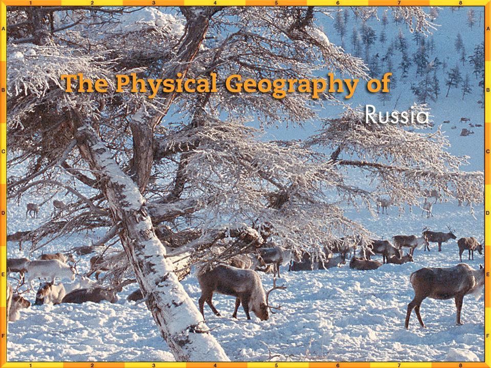
Chapter 14. The Physical Geography of Russia
|
|
|
- Mark Dawson
- 6 years ago
- Views:
Transcription
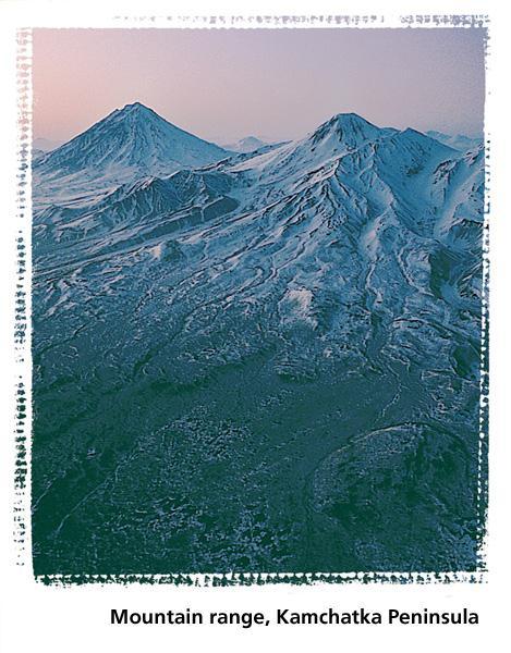
1 Chapter 14 The Physical Geography of Russia
2
3 Chapter Objectives Identify the physical features and natural resources of Russia. Discuss the effects of Russia s climate and vegetation on life in the region.
4 THE LAND Section 1
5 Section Objectives Describe the size of Russia s land area. Discuss how Russia s interconnected plains and mountain ranges shape settlement in the country. Identify Russia s natural resources.
6 Terms to know chernozem hydroelectric power permafrost
7 A Geographic View
8 Geographic LIteracy Many active volcanoes are found in far eastern Russia, where the Kamchatka Peninsula lies within the Ring of Fire, the belt of volcanic activity surrounding the Pacific Ocean. Four volcanoes in Kamchatka Kliuchevskoi, Tolbachik, Shiveluch, and Bezymianny last erupted in 1999.
9 A Vast and Varied Land Mountains and Plateaus Stretching across parts of Europe and Asia, Russia is a huge land of plains divided and bordered by mountains and plateaus. The Urals are old, worn-down mountains that mark the boundary between European and Asian parts of Russia. The Caucasus Mountains in the southwest reach their highest elevation at Mount Elbrus, 18,510 ft. (5,642 m), Russia s highest point. Mountain ranges also form a rugged natural boundary between Russia and China.

10 Vast and Varied Land
11 Vast and Varied Land Plains Areas The North European Plain covers most of European Russia. The southern part of the plain has rich soil, and about 75 percent of the Russian population lives there. Coasts, Seas, and Lakes Russia has the longest continuous coastline of any country, at 23,400 miles (37,650 km). The coastline touches the Arctic and Pacific Oceans and the Baltic, Black, and Caspian Seas.

12 Vast and Varied Land
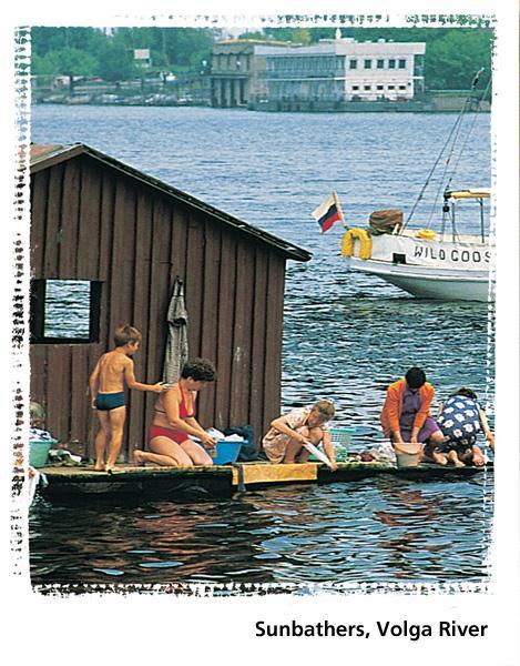
13 Rivers Most of Russia s longest rivers are in sparsely populated Siberia. Siberians enjoy a surplus of freshwater, but European Russians often face water shortages or problems with water quality. The Volga River The Volga is the fourth-longest river in Russia and the longest river in Europe. Siberian Rivers Siberian rivers flow north to the Arctic Ocean. Blocked by ice, meltwaters often flood the land and create vast swamps.
14 Natural Resources Minerals and Energy Russia has huge mineral resources. It is especially rich in mineral fuels, such as oil, natural gas, and coal. Russia s rivers make it a leading producer of hydroelectric power. Soil and Forest Land Because of Russia s generally cold climate, only about 10 percent of Russia s land is suitable for farming. A rich, fertile Black Earth Belt, however, stretches from Ukraine to southwestern Russia, supplying the country with grains, sugar beets, and other produce.
15 Natural Resources About one-fifth of the world s forested land is in Siberia. Russian forests supply much of the world s timber. Russia s Fishing Industry Fish is a staple food in Russia and also an important export.
16 CLIMATE AND VEGETATION Section 2
17 Objectives List Russia s major climates. State what seasons are like in Russia. Explain how climate affects the way Russians live. Classify the types of natural vegetation found in each of Russia s climate regions.
18 Terms to Know Tundra Taiga Steppe
19 Geographic View
20 Geographic Literacy The coldest temperature ever recorded in Asia was in Russia. On February 6, 1933, the temperature in the Siberian town of Oimekon was -90ºF. The same temperature was recorded on February 7, 1892, in Verkhoyansk, another Siberian location.
21 Russia s Climate and Vegetation Most of Russia has a harsh climate with long, cold winters and short, relatively cool summers. Lying well within the Eurasian landmass, most of the country is far away from any moderating ocean influences.
22 High Latitude Climates Tundra The tundra, a vast, treeless plain, covers about 10 percent of Russia. The weather is always cold, and little grows there because of the short growing season and the thin acidic soil. Subarctic The subarctic lies just south of the tundra. The subarctic has snow for up to 250 days of the year. The taiga is a forest belt in the subarctic that is the world s largest coniferous forest.
23 High Latitudes Living in a Cold Climate Russians must be creative to live in an extremely cold climate. Builders plan for the cold when they construct buildings, and cars are made from a special type of steel that will not crack in the cold. Large amounts of oil, gas, wood, and coal are used to keep warm.

24 High Latitudes
25 Mid Latitudes Humid Continental Most of the North European Plain and some of southern Siberia have a humid continental climate, with long, snowy, relatively mild winters. In humid continental areas of Russia, the coniferous taiga of the north gives way to mixed coniferous-deciduous forests. War and Winter Russia s cold climate was helpful in World War II because Russian soldiers, who were used to the cold, fought well against the German soldiers, who were unprepared for a brutal winter. Steppe The steppe climate region has dry summers and long, cold, dry winters. Its rich soil enables a variety of grasses and plants to flourish.

26 Mid Latitudes
27 Section 1 Summary Russia is the largest country in the world, spanning Europe and Asia. Russia s land consists of interconnected plains and plateaus and is bordered on the south and east by mountain ranges. Most rivers in Russia flow northward and are frozen for much of the year. Russia is rich in resources, such as petroleum, coal, minerals and gems, and timber.
28 Section 2 Summary Most of Russia has a harsh climate with wide extremes of temperatures, which creates challenges in all aspects of Russian life. Russian winters are long and cold, and its summers are short and relatively cool. Permanently frozen subsoil, or permafrost, lies beneath much of Siberia. The vegetation in Russia is varied, with treeless tundra in the far north, densely wooded taiga in the north and central areas, and temperate steppe grasslands in the southwest.
Label your Map with Russia. Map Activity
 Bell Activity How many time zones does the U.S. have? How do these time zones affect life in the U.S.? Russia is so large it has 11 time zones. What difficulties might this create? Objectives Know landforms,
Monday, December 11, 2017
 Monday, December 11, 2017 Physical Geography of Russia Objective: complete Warm-Up, write outline notes and discuss the geography of Eastern Europe/mother Russia and view Geography Now: Belarus. География
CH. 1 Europe and Russia: Physical Geography. Section 1 Land and Water p Europe and Russia are part of the world s largest landmass called.
 CH. 1 Europe and Russia: Physical Geography Section 1 Land and Water p.10-16 Europe and Russia are part of the world s largest landmass called. The country of Russia stretches over both continents. About
Chapter 2A: The Russian Realm
 Geography: Realms, Regions, and Concepts 16 th Edition Chapter 2A: The Russian Realm The Russian Realm Two transition zones mark the margins. The Russian Realm Two transition zones mark the margins. Physical
Chapter 15: RUSSIA & The REPUBLICS
 Chapter 15: RUSSIA & The REPUBLICS Ch. 15:1 Landforms & Resources The Northern European Plain stretches for over 1,000 miles between the western border of Russia & the Republics and the. Ural Mountains
Location, Climate, & Natural Resources
 Location, Climate, & Natural Resources UK is a country of islands off the coast of mainland Europe. It consists of England, Northern Ireland, Scotland, & Wales. UK s location makes it a HUB for trade.
GEOGRAPHY AND HISTORY
 GEOGRAPHY AND HISTORY YEAR 1, PART 1 www.vicensvives.es Contents 01 Our planet Earth 02 The representation of the Earth: maps 03 The Earth s relief 04 Rivers and seas 05 Weather and climate 06 Climates
Terms to Know. artesian well coral atoll krill lagoon
 Chapter Objectives Describe the diverse landforms and natural resources of Australia, Oceania, and Antarctica. Discuss the wide range of climates and vegetation throughout the region. The Land Section
Location, Climate, & Natural Resources Brain Wrinkles
 Location, Climate, & Natural Resources Standards SS6G10 The student will explain the impact of location, climate, natural resources, and population distribution on Europe. a. Compare how the location,
Chapter Objectives. Describe the dominant landforms and natural resources of Southeast Asia. Discuss Southeast Asia s climate and vegetation.
 Chapter Objectives Describe the dominant landforms and natural resources of Southeast Asia. Discuss Southeast Asia s climate and vegetation. The Land Section 1 Objectives Describe how tectonic plates and
STUDY GUIDE. The Land. Physical Features of Latin America. Chapter 8, Section 1. Terms to Know DRAWING FROM EXPERIENCE ORGANIZING YOUR THOUGHTS
 For use with textbook pages 193 198. The Land Terms to Know cordillera A mountain range that runs parallel to another mountain range (page 194) altiplano A high plain (page 194) escarpment A steep cliff
Chapter 13 Eastern Europe & Western Russia: Recovering from war, communism, genocide, and unfortunate geography (Pg )
") Chapter 13 Eastern Europe & Western Russia: Recovering from war, communism, genocide, and unfortunate geography (Pg. 393-420) Lesson 1: Physical Geography of Eastern Europe & Western Russia Pg. 396-401
Chapter 13 Eastern Europe & Western Russia: Recovering from war, communism, genocide, and unfortunate geography (Pg. 393-420) Lesson 1: Physical Geography of Eastern Europe & Western Russia Pg. 396-401
STUDY GUIDE. The Land. Chapter 29, Section 1. Both. Terms to Know DRAWING FROM EXPERIENCE ORGANIZING YOUR THOUGHTS
 Chapter 29, Section 1 For use with textbook pages 719 724. The Land Terms to Know cordilleras Parallel mountain ranges and plateaus (page 719) archipelago A group of islands (page 720) insular Relating
EXPLORING BIOMES IN GORONGOSA NATIONAL PARK
 EXPLORING BIOMES IN GORONGOSA NATIONAL PARK ABOUT THIS WORKSHEET This worksheet complements the Click and Learn Gorongosa National Park Interactive Map (http://www.hhmi.org/biointeractive/gorongosa-national-park-interactive-map),
Chapter 17. North Africa, Southwest Asia and Central Asia
 Chapter 17 North Africa, Southwest Asia and Central Asia Chapter Objectives Describe the major landforms and natural resources of North Africa, Southwest Asia, and Central Asia. Discuss the climate and
The Geological Pacific Northwest. Wednesday February 6, 2012 Pacific Northwest History Mr. Rice
 The Geological Pacific Northwest Wednesday February 6, 2012 Pacific Northwest History Mr. Rice 1 Free Response #2 Please do not simply list the items for this response. Full sentences!!! Minimum of 3-5
Europe. World Geography
 Europe World Geography Physical Geography Europe s landforms also include large plains and mountain ranges. Europe is composed of many peninsulas and islands. Always near Water Europe is a large peninsula
Ms. Susan M. Pojer Horace Greeley HS Chappaqua, NY
 Ms. Susan M. Pojer Horace Greeley HS Chappaqua, NY Europe as a Queen Munster, 1588 Europe s s Latitude v. US Former Soviet Region Compared in Latitude & Area with the United States Satellite View of Europe
Chapter 20. The Physical Geography of Africa South of the Sahara
 Chapter 20 The Physical Geography of Africa South of the Sahara Chapter Objectives Identify the major landforms, water systems, and natural resources of Africa south of the Sahara. Describe the relationship
Friday, November 10, 2017
 Friday, November 10, 2017 Andes and Midlatitude Countries Objective: Summarize the main physical features and regions of the Southern Cone. Identify and locate the urban centers and understand the pattern
Latin America. Chapter 9 Physical Geography
 Latin America Chapter 9 Physical Geography Latin American Regions Middle America includes Mexico and the Central American countries The Caribbean Islands South America Mexico Landforms Sierra Madre Oriental
,/ /fuor/vu. 2O4 Unit 4. .\ Lapte. _--/ 500/ /11,000 kilometers --\ I R 2\::% Bar'ents,/ ZemlYa ATLANTIC OCEAN. Black Sea
 F urope and Russia occupy E patt of the huge landmass called Eurasia. Eurasia reaches from the Atlantic to the Pacific Ocean. lt is so large that geographers divide it into two continents, Europe and Asia.
Latin America. Introduction
 Latin America Introduction What are the 5 Themes of Geography? Draw lines to connect the theme to the definition: Location How humans and the environment impact each other Physical and human characteristics
Oceania. Australia, New Zealand, and the Pacific Islands. Physical Geography. Where is Australia located?
 Oceania Australia, New Zealand, and the Pacific Islands Physical Geography Australia New Zealand Oceania Where is Australia located? Australia & Oceania are a group of islands located between Asia, Antarctica,
LOCATION, CLIMATE, AND NATURAL RESOURCES OF MEXICO
 SS6G3 The student will explain the impact of location, climate, distribution of natural resources, and population distribution on Latin America and the Caribbean. a. Compare how the location, climate,
Just how big is Africa?
 The United States China India The United Kingdom Portugal Spain France Belgium Germany The Netherlands Switzerland Italy Eastern Europe Japan 11.7 million sq. miles Just how big is Africa? Chapter 18 Section
Physical Geography of Europe. Chapters 13-18
 Physical Geography of Europe Chapters 13-18 The British Isles Archipelago made of 6000+ small islands Temperate climate Largest body of fresh water is Loch Ness Mostly rolling hills and large flat lands
Objective. Students will familiarize themselves with the physical features and climates of Latin America.
 Journal Write KWL What do you KNOW about Latin America? What do you WANT TO KNOW about Latin America? What did you LEARN today that you didn t know before? Latin America Objective Students will familiarize
Chapter 7 Geography and the Early Settlement of Egypt, Kush, and Canaan
 Chapter 7 Geography and the Early Settlement of Egypt, Kush, and Canaan How did geography affect early settlement in Egypt, Kush, and Canaan? Section 7.1 - Introduction RF/NASA//Corbis This satellite photograph
Geography: Unit 2. Map. Rivers. Major Physical Features. Slide 1. Slide 2. Slide 3. Slide 4. North America United States and Canada.
 Mississippi River Slide 1 Slide 2 Slide 3 Slide 4 Geography: Unit 2 North America United States Map Major Physical Features Mountain Ranges Brooks Range Mackenzie Mountains Coast Mountains Cascades Sierra
STUDY GUIDE. The Land. Chapter 20, Section 1. The Land of Africa South of the Sahara. Landforms Water Systems Natural Resources.
 For use with textbook pages 499 504. The Land Terms to Know escarpment A steep, often jagged slope or cliff (page 500) cataract A towering waterfall (page 500) rift valley A large crack in the earth s
Match the names below with their locations on the map by writing the correct letter in the blank.
 P r e v i e w Match the names below with their locations on the map by writing the correct letter in the blank. Physical Features of Canada 60ºN 70ºN 80ºN A R C T I C O C E A N 130ºW 120ºW 110ºW 90ºW 70ºW
Introduction to Africa
 Introduction to Africa Did you know? Africa has more countries than any other continent. The Sahara is a desert that is the size of the U.S. It s the world's largest desert. Most of the world s gold and
MCGRAW-HILL EUROPE. Chapter 11 Physical Geography Pages 332 to 341
 MCGRAW-HILL EUROPE Chapter 11 Physical Geography Pages 332 to 341 Countries of Western Europe Benelux Countries UK, France, Luxembourg, Germany, Netherlands, Belgium, Austria, Switzerland, Belgium, Monaco,
South, Southeast, and East Asia Physical Geography
 South, Southeast, and East Asia Physical Geography Mountains A. B. C. Mountains are important in Asia because they influence: Population patterns Movement of people and goods Climate Himalaya Mountains
Latin America and The Caribbean. A Closer Look.
 Latin America and The Caribbean A Closer Look. Mexico Capital: Mexico City The Location of Mexico Mexico is the second-largest country by size and population in Latin America.but the Largest Spanish -
STUDY GUIDE. The Land. Chapter 17, Section 1. There are frequent earthquakes in the region. Petroleum is a major export in the region.
 For use with textbook pages 421 426. The Land Terms to Know alluvial soil A rich soil made up of sand and mud deposited by flowing water (page 423) wadi A streambed that remains dry until a heavy rain
Chapter 7. Geography and the Early Settlement of Egypt, Kush, and Canaan
 Chapter 7 Geography and the Early Settlement of Egypt, Kush, and Canaan Chapter 7 Geography and the Early Settlement of Egypt, Kush, and Canaan How did geography affect early in Egypt Kush, and Canaan?
^-.^.^TK'^^.?' ".. Information and Exercises. about. The Territories. Yukon Territory Northwest Territories. Nunavut Territory.
 ^-.^.^TK'^^.?' ".. Information and Exercises about The Territories Yukon Territory Northwest Territories Nunavut Territory Whitehorse, Yukon fyukon TERRITORY ] Key Words: taiga- northern forest area boreal-
Latin America. Physical Geography
 + Latin America Physical Geography + I. Landforms A. Caribbean & Central America 1. Mexico is dominated by two mountain chains, collectively called the Sierra Madre. A high plateau is situated in between.
Academic Vocabulary Social Studies, 5-8 (adapted from Building Academic Vocabulary by Robert Marzano.)
") Academic Vocabulary Social Studies, 5-8 (adapted from Building Academic Vocabulary by Robert Marzano.) Provide a student-friendly description, explanation, or example of the term. 7 Continents of the World
Academic Vocabulary Social Studies, 5-8 (adapted from Building Academic Vocabulary by Robert Marzano.) Provide a student-friendly description, explanation, or example of the term. 7 Continents of the World
Chapter 21: EAST AFRICA
 Chapter 21: EAST AFRICA Physical Geography of East Africa Landforms East Africa is a diverse landscape of different plains, volcanic mountains, and plateaus cut by a large valley and marked by many rivers
Geography: Unit 2. Map. Major Physical Features. Rivers. Mississippi River Missouri River Ohio River Rio Grande. Mackenzie. Colorado River Green River
 1 2 3 4 Geography: Unit 2 North America United States and Canada Map Major Physical Features Mountain Ranges Brooks Range Mackenzie Mountains Coast Mountains Cascades Sierra Nevada Rocky Mountains Appalachian
Varied Lands and Varied Resources Chapter 9 Lesson 1
 Varied Lands and Varied Resources Chapter 9 Lesson 1 16 independent countries make up region of Europe From in north to Balkan Peninsula in south Eastern Europe four separate sub regions Western Balkans
Subject: Social Studies
 SY 2018/2019 1 st Final Term Revision Student s Name: Grade: 6A/B Subject: Social Studies Teacher Signature Worksheets in Social Studies 6 Unit 2 Lesson 3 World Seas pages 37-40 WB. Pp. 22-25 Lesson 4
NAME: SURNAME: DATE: PHOTOQUIZ 1 EXERCISE. Photo 1: Answer A: France. Photo 2: Answer B: United Kingdom. Photo 3: Answer C: Portugal
 NAME: SURNAME: DATE: ID STUDENT: 001 ID EXERCISE:001 PHOTOQUIZ 1 EXERCISE Course: GEOGRAPHY Chapter: FLAGS PHOTO TITLE Photo 1: Answer A: France Photo 2: Answer B: United Kingdom Photo 3: Answer C: Portugal
The Geography of the Middle East
 The Geography of the Middle East Unit 1 Focus The focus of this unit is how physical and cultural geography shape the environment, nations, and people of the Middle East The Middle East is also called
Italy. Country Profile. April 2012
 Italy Country Profile April 2012 BACKGROUND The territory of Italy covers some 301,338 km 2 (116,347 sq mi) and is influenced by a temperate seasonal climate. With 60.6 million inhabitants, it is the fifth
World History: Patterns of Interaction
 The Americans: A Separate World, 40,000 B.C. A.D. 700 Although early American civilizations remain mysterious, we know that the earliest Americans most likely migrated from Asia and that complex cultures
Do Not Write On This Sheet. World Rally. City, country, continient: to city, country, continent:
 World Rally At each checkpoint you must list the city, country, and continent. The teacher must check all answers before you can go on to the next checkpoint. Checkpoint 1: Start at: 29 N 98 W and go to:
AFRICAN PHYSICAL GEOGRAPHY
 AFRICAN PHYSICAL GEOGRAPHY Here are some factoids about Africa: world s second largest continent (11,700,000 miles). Home to 52 countries, 1,000 languages, 800 million people. 10% of the world s population
UNIT 5 PHYSICAL GEOGRAPHY SG 1 - PART I
 UNIT 5 PHYSICAL GEOGRAPHY SG 1 - PART I Africa is HUGE! I. LANDFORMS A. Plateaus - an area of relatively level high ground. 1. Africa s interior is dominated by series of plateaus and elevated basins such
DENMARK. CHAPTER TWELVE Section Two. DENMARK and ICELAND DENICE. Greenland too!
 CHAPTER TWELVE Section Two and ICELAND DENICE Greenland too! KEY QUESTION The success of Denmark can be traced to its' relationship with Europe. Explain Population: 5,325,000 Size: 16,638 sq. miles
South American Countries. Capital Location Population Terrain Climate
 South American Countries Capital Location Population Terrain Climate Andes Mountains Four large areas that make up the Central Plains: Llanos, the Selva, the Gran Chaco, and the Pampas Brazilian Highlands
Latin America s Physical Geography. EQ: What are characteristics of Latin America s physical features?
 Latin America s Physical Geography EQ: What are characteristics of Latin America s physical features? Your Task: We are going to participate in a Museum Walk! You will travel around the room with a partner
Mexico. Chapter 10. Chapter 10, Section
 Chapter 10, Section World Geography Chapter 10 Mexico Copyright 2003 by Pearson Education, Inc., publishing as Prentice Hall, Upper Saddle River, NJ. All rights reserved. Chapter 10, Section World Geography
The Land Photo Source: The Atlas of Canada, The Red River, Manatoba, Canada land/physio_red_ri
 The Land The United States and Canada An Overview of the Region The United States and Canada are the two largest countries in North America. The Rio Grande is part of the southwest border of the United
So far, you have looked at grasslands and three different
 Chapter Seven: Page 54 So far, you have looked at grasslands and three different types of forests: deciduous, coniferous and tropical rain forests. Now you will study two more biomes: and ( tun-dur-ah
Exploring Mexico. Directions: Complete the paragraphs below. Write the correct word from the Word Bank to complete each sentence.
 Exploring Mexico Section 1 10 Directions: Complete the paragraphs below. Write the correct word from the Word Bank to complete each sentence. Word Bank United States Central Plateau irrigation isthmus
World Geography Ch. 7.2 Climate Regions of Latin America
 World Geography Ch. 7.2 Climate Regions of Latin America BR: D10 When you think of Latin America, what types of climates do you think are down there? Write down which of the following you believe are there:
Europe is the second smallest continent by land size. It is made up of over 50 countries and has a wide variety of climate and geographical features.
 Europe is the second smallest continent by land size. It is made up of over 50 countries and has a wide variety of climate and geographical features. ORAL DISCUSSION Think about what you already know about
2015 Brain Wrinkles. SS8G1b
 SS8G1b Georgia is a geographically diverse state that is divided into five regions. The first three regions (Appalachian Plateau, Valley and Ridge, and Blue Ridge) are in the mountains and foothills of
Geographic Qualities of South America
 Geographic Qualities of South America 1. South America is the fourth largest continent in area. It is located in the Western Hemisphere, lying southwest of North America. Most of South America lies in
Latin America. Physical Geography
 Latin America Physical Geography Regions Latin America can be divided into separate regions based on physical geography or cultural geography. Regions If we look at physical geography Latin America has
Wednesday, April 4, 2018
 Wednesday, April 4, 2018 Physical Geography of Japan Objective: Outline the countries and territories that are included in East Asia. Describe the main physical features and climate types of each country.
SS7G1 The student will locate selected features of Africa.
 Standards SS7G1 The student will locate selected features of Africa. a. Locate on a world and regional political-physical map: the Sahara, Sahel, savanna, tropical rain forest, Congo River, Niger River,
Unit 1. School Days. First Nine Weeks
 Study Buddy Unit 1 School Days First Nine Weeks Teacher- A person who helps us learn. Map- A drawing that shows where places are. Group- A number of people doing an activity together. Rule- What you must
OUR COUNTRY INDIA L OCATIONAL SETTING
 7 India is a country of vast geographical expanse. In the north, it is bound by the lofty Himalayas. The Arabian Sea in the west, the Bay of Bengal in the east and the Indian Ocean in the south, wash the
Physical Regions of the U.S.
 Physical Regions of the U.S. Quickly use this map to label the map on your paper Pacific Coast The coast from southern California to Alaska The region of the Pacific Northwest has a long history that was
OUR EUROPE - NORTHERN EUROPE
 OUR EUROPE - NORTHERN EUROPE Europe is a small continent. People live very close to each other. More than seven hundred million people live here. Europe consists of almost fifty countries. More than half
6th Grade Social Studies Chapter 7: The Geography and Early Settlement of Egypt, Kush and Canaan
 I. Introduction (7.1) A. Egyptians settled along the Nile River, in the NE corner of Africa B. civilization lasted from around 3100 B.C. to 350 C. E. C. Kushites settled to the south of Egypt, along the
Chapter 1 Test A (1 of 5)
") Chapter 1 Test A (1 of 5) Vocabulary Match the descriptions with the correct terms. (8 points) Column I 1. a natural feature of Earth s surface 2. something in the environment that people use 3. the pattern
Chapter 1 Test A (1 of 5) Vocabulary Match the descriptions with the correct terms. (8 points) Column I 1. a natural feature of Earth s surface 2. something in the environment that people use 3. the pattern
COUNTRY DATA: Costa Rica : Information from the CIA World Factbook! INTRODUCTION GEOGRAPHY
 ! COUNTRY DATA: Costa Rica : Information from the CIA World Factbook! INTRODUCTION GEOGRAPHY Location Area Central America, bordering both the Caribbean Sea and the North Pacific Ocean, between Nicaragua
Unit 1: Physical Geography Notes
 - How has the physical world impacted settlement patterns? o Major factors in the decision-making process of o Before the boom controlling the physical environment was not possible on a large scale - Physical
Mediterranean Europe
 Chapter 17, Section World Geography Chapter 17 Mediterranean Europe Copyright 2003 by Pearson Education, Inc., publishing as Prentice Hall, Upper Saddle River, NJ. All rights reserved. Chapter 17, Section
Curriculum Pacing Guide Grade/Course 5 Th Grade Geography Grading Period 1 st Nine Weeks
 2013-2014 Curriculum Pacing Guide Grade/Course 5 Th Grade Grading Period 1 st Nine Weeks Time Frame Unit/ photographs, pictures, and tables to Locate and identify: Continents and Oceans -North America
Australian Geography. Standards:
 Australian Geography Standards: SS6G12 The student will be able to locate selected features of Australia. a. Locate on a world and regional political-physical map: the Great Barrier Reef, Coral Sea, Ayers
Essential Questions. 1. How have historical figures and events affected South America today?
 South America Essential Questions 1. How have historical figures and events affected South America today? 2. How has location affected the development of countries in South America? 3. How has the role
Brain Wrinkles. Africa: The impact of location, climate, & physical characteristics on where people live, the type of work they do, & how they travel
 Africa: The impact of location, climate, & physical characteristics on where people live, the type of work they do, & how they travel STANDARDS: SS7G3 The student will explain the impact of location, climate,
Economy 3. This region s economy was based on agriculture. 4. This region produced items such as textiles, iron, and ships in great quantities. For th
 Geography 1. This region has a climate of warm summers and snowy cold winters. 2. This region has a climate that is generally warm and sunny, with long, hot, humid summers, and mild winters, and heavy
CHAPTER 12. South America. Section 1: Natural Environments Section 2: History and Culture Section 3: South America Today. HOLT World Geography
 CHAPTER 12 South America Section 1: Natural Environments Section 2: History and Culture Section 3: South America 1 Section 1 Natural Environments Objectives: What are the major landforms and rivers of
Chapter 7: The Geography and Settlement of Egypt, Kush, and Canaan
 Chapter 7: The Geography and Settlement of Egypt, Kush, and Canaan Learning Target: I can explain how geography affected early settlement in Egypt, Kush, and Canaan. Ancient Egypt and the Middle East Can
PHYSICAL GEOGRAPHY. Unit 1
 PHYSICAL GEOGRAPHY Unit 1 HOW HAS THE PHYSICAL WORLD IMPACTED SETTLEMENT PATTERNS? Major factor in the decision-making process of settlers Before the technological boom controlling the physical environment
STANDARDS: Brain Wrinkles
 STANDARDS: SS6G3 The student will explain the impact of location, climate, distribution of natural resources, and population distribution on Latin America and the Caribbean. a. Compare how the location,
Brazil. Chapter 12. Chapter 12, Section
 Chapter 12, Section World Geography Chapter 12 Brazil Copyright 2003 by Pearson Education, Inc., publishing as Prentice Hall, Upper Saddle River, NJ. All rights reserved. Chapter 12, Section World Geography
Portuguese Language - Fostering National Unity
 Geography Brazil Brazil Portuguese Language - Fostering National Unity 11 dialects of Portuguese Influenced by Amerindian and African languages, creating differences between Portuguese spoken in Brazil
Information about the region
 13-16 February 2018 Information about the region In Brief Siberian Federal District (SFD) federal district in the Siberian part of Russia. It was created by presidential decree on May 13, 2000. The SFD
European Countries. Central Europe (11) Germany Czech Republic Poland Estonia Latvia Lithuania Austria Switzerland Hungary Slovakia Liechenstein
 Germany Czech Republic Poland Estonia Latvia Lithuania Austria Switzerland Hungary Slovakia Liechenstein") European Countries North/ West Europe (11) Ireland UK France Sweden Finland Denmark The Netherlands Belgium Luxembourg Iceland Monaco Central Europe (11) Germany Czech Republic Poland Estonia Latvia Lithuania
European Countries North/ West Europe (11) Ireland UK France Sweden Finland Denmark The Netherlands Belgium Luxembourg Iceland Monaco Central Europe (11) Germany Czech Republic Poland Estonia Latvia Lithuania
ì<(sk$m)=beicea< +^-Ä-U-Ä-U
=beicea< +^-Ä-U-Ä-U") Fascinating Facts The Nile River in Egypt is the world s longest river, but the Amazon River in Brazil moves the most water. The world s largest freshwater lake is Lake Baikal in Russia. The highest temperature
Fascinating Facts The Nile River in Egypt is the world s longest river, but the Amazon River in Brazil moves the most water. The world s largest freshwater lake is Lake Baikal in Russia. The highest temperature
The Maltese Islands: Geography
 The Maltese Islands: Geography The Maltese Archipelago comprises a group of small low islands aligned in a NW-SE direction. At their extreme points the Maltese Islands fall within the following points:
Africa s. Presentation, Graphic Organizers, & Activities
 Africa s Presentation, Graphic Organizers, & Activities STANDARDS: SS7G1 Locate selected features of Africa. a. Locate on a world and regional political-physical map: Sahara, Sahel, savanna, tropical rain
Ancient Egypt and the Near East
 *O*»f ' i ft Ancient Egypt and the Near East Chapter 7 Chapter 8 Chapter 9 Geography and the Early Settlement of Egypt, Kush, and Canaan The Ancient Egyptian P h a r a o h s Daily Life in Ancient Egypt
Pine Crest Elementary School Geography Bowl Explore Asia, the Middle East and Europe
 Pine Crest Elementary School Geography Bowl 2017-2018 Explore Asia, the Middle East and Europe First and Last Name: Homeroom Teacher: Grade: Welcome to the Pine Crest Elementary School Geography Bowl!
LAST TIME (Happy 300 th Birthday Ben Franklin!)
") LAST TIME (Happy 300 th Birthday Ben Franklin!) Latin American Diversity: Introduction Physical Geography of Mexico, Caribbean, and Central America: 1. Mexican drylands 2. Mesoamerican Highlands 3. Coastal
LAST TIME (Happy 300 th Birthday Ben Franklin!) Latin American Diversity: Introduction Physical Geography of Mexico, Caribbean, and Central America: 1. Mexican drylands 2. Mesoamerican Highlands 3. Coastal
Chapter 11 Study Guide Western Europe
 Chapter 11 Study Guide Western Europe I. Northern Europe: Consists of and A. United Kingdom (Constitutional Monarchy and has political divisions) *, and make up the island known as Great Britain, while
Brain Wrinkles. Location, Climate, & Natural Resources of. Where People Live & How They Trade
 Location, Climate, & Natural Resources of Where People Live & How They Trade It s south of the US, east of the Pacific Ocean, and west of the Gulf of Mexico & Caribbean Sea. It s great that it s located
SS8G1 The student will describe Georgia with regard to physical features and location.
 SS8G1ab Standards SS8G1 The student will describe Georgia with regard to physical features and location. a. Locate Georgia in relation to the region, nation, continent, and hemispheres. b. Describe the
Mrs. Reifsnyder World Geography. Unit 8: Latin America Study Guide SOLs Addressed: WG. 1c, 2b, 3c, 4, 10b/c
 Mrs. Reifsnyder World Geography Unit 8: Latin America Study Guide SOLs Addressed: WG. 1c, 2b, 3c, 4, 10b/c Essential Questions: - In what ways do physical, economic, and cultural characteristics influence
What Is An Ecoregion?
 Ecoregions of Texas What Is An Ecoregion? Ecoregion a major ecosystem with distinctive geography, characteristic plants and animals, and ecosystems that receives uniform solar radiation and moisture Sometimes
Colorado Life Zone Scavenger Hunt
 Colorado Life Zone Scavenger Hunt Below are worksheets created for all the habitats or life zones. They were designed with the intention of breaking the class up into small groups, and having students