Latin America. Physical Geography
|
|
|
- Bertina Wilson
- 5 years ago
- Views:
Transcription
1 + Latin America Physical Geography
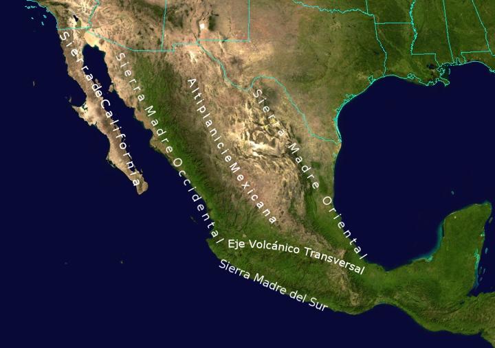
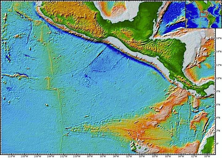
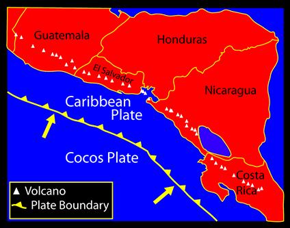
2 + I. Landforms A. Caribbean & Central America 1. Mexico is dominated by two mountain chains, collectively called the Sierra Madre. A high plateau is situated in between. 2. The mountains of Central America are volcanic due to the subduction of the Cocos Plate underneath the North American plate (What type of boundary?). 3. Both Mexico and the countries of Central America are subject to volcanic eruptions and earthquakes. 4. The Caribbean Islands are also affected by plate boundaries (What type of boundary?). Many of the islands of the Caribbean are volcanic islands (What type of landform created?).
3
4
5

6 %2Fwww.youtube.com%2Fwatch%3Fv%3D8sPyyHY57H4)
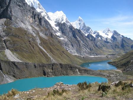
7 + I. Landforms B. South America 1. The Andes Mountains dominate the western edge of the continent. a. It is the 2 nd highest mountain chain in the world. b. Formed from the subduction of the Nazca plate underneath the South American plate (What type of boundary?) c. There are two ranges collectively called the Cordillera. 2. Two large plateaus: the Brazilian & Guiana Highlands are found on either side of the Amazon rainforest.
8 Cordillera

9 Mato Grasso Plateau
10 + II. Climate A. The Latin America region extends through almost 90 degrees of latitude. This is the greatest north-south distance of any major world region. B. Mexico, the Caribbean & Central America 1. Lies within the tropics & dominated by Northeast Trade winds for about 2/3 of the year. This causes consistent warmth and humidity in the region. 2. Modified cold air masses called nortes sometime affect those regions farthest to the north. 3. The Caribbean Islands have windward and leeward sides affected by rainfall in the summer months. For example, in Jamaica, the windward side of the island receives about 130 inches/year while the leeward side receives only about 31 inches. 4. Hurricanes during the summer months are also a dominate weather occurrence.
11
12 + II. Climate C. South America 1. In Brazil, the northern part of the country experiences a tropical rainy climate year-round. 2. North of Brazil, in the area of the Guiana Highlands a tropical wet/dry climate is more dominate. 3. However due to latitude, the northeastern corner of Brazil is prone to prolonged droughts. 4.In the southern part of Brazil the climate is more temperate, with a shorter growing season. 5. In northern Chile, the Atacama Desert is situated between the cold Humboldt Current in the Pacific and the Andes Mtn. It is one of the driest places on Earth. 6. The Patagonia region of Argentina is arid due to a cold water current off the southeast coast.
13 +II. Climate D. The El Niño Southern Oscillation (ENSO) 1. The ENSO is an episodic atmospheric & oceanic phenomenon of the Pacific Ocean near around the Equator. It is particular noticeable off the western coast of South America. 2. Normally, the waters off the west coast of S.A. are cool, air pressure type is subtropical high where air is descending causing the Trade winds. These winds push water off the coast towards the east. This causes cooler water to be brought up to the surface.
14 + II. Climate 3. On the other side of the Pacific, the pattern is quite different. Near Indonesia, water is piling up due to the winds, the western Pacific is about 2 10 inches higher than the eastern Pacific. The water is warm, and there are lots of thunderstorms and rain. 4. Every few years this normal pattern changes. Pressure changes in the western Pacific cause a decrease in the Trade winds and the warm water starts moving east towards S.A. This can take several months. When this warm water reaches S.A. It changes the pressure pattern and an ENSO event takes place. 5. While this I most noticeable in S.A., it affects weather patterns worldwide.
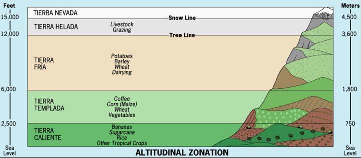
15 + II. Climate E. The majority of the high mountain ranges in S.A. are located within tropical latitudes. This creates vertical zones with distinctive climate and vegetation. This is called altitudinal zonation and is more obvious at the equator. 1. tierra caliente: from sea level to about 2,500 ft; warm to hot conditions, and tropical forest. 2. tierra templada: from 2,500 6,000 ft; mild to warn temperatures, deciduous forests. 3. tierra fría: from 6,000 12,000 ft; cold to mild temperatures, pine forests 4. tierra helada: 12,000 15,000; colder temperatures, grasslands 5. tierra nevada: 15,000 ft and up; snow cover year-round, even on the equator
16
17 + III. River Basins A. Three major river systems dominate the S.A. 1. The Amazon River Basin A. The world s largest river by volume. 2. The Orinoco River Basin 3. The Paraná - Paraguay River Basin v=wrw5v55pwr0&spfreload=10%20message%3a%20json%20parse %20error%3A%20Unexpected%20EOF%20(url%3A%20https%3A %2F%2Fwww.youtube.com%2Fwatch%3Fv%3DWrW5V55pwR0)

18
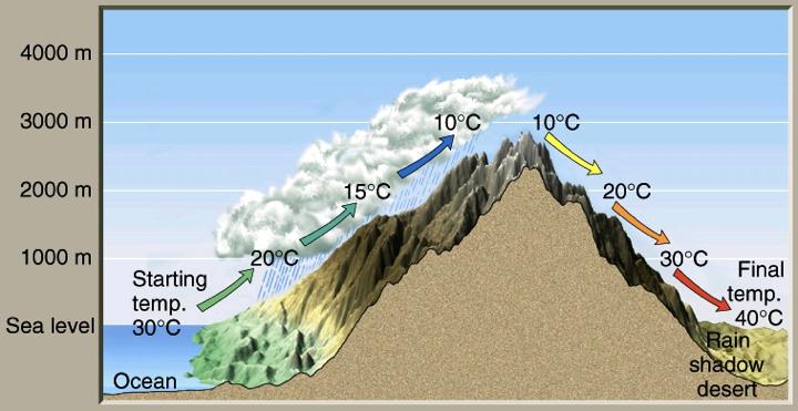
19
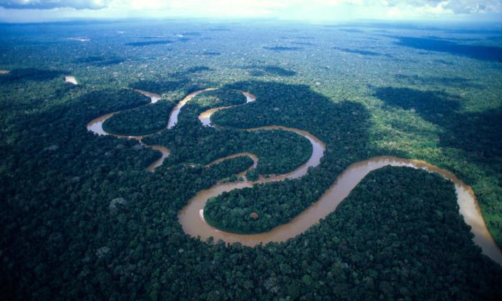
20 + IV. Natural Vegetation A. Tropical rainforest persists year-round in the Amazon River Basin, along the northern Pacific & Central American coasts, and on some of the Caribbean Islands. The world s largest expanse of rainforest is found in Brazil. B. The pampas are tall, lush temperate grasslands found in central Argentina & Uruguay. C. The llanos are tropical grasslands found in northern S.A. mainly in Venezuela & Colombia.

21 Pampas 21

22 Llanos 22

23 Capybara 23
24 + V. Natural Resources A. The Andes Mtns. provide considerable mining opportunities for metal ores such as gold, silver, & copper. This was a major reason for the colonization of S.A. by Spain & Portugal. B. The pampas provide good soil for agriculture and grazing land for livestock. C. The rivers combined with the natural relief provide opportunities for hydroelectricity. D. Offshore drilling of oil and natural gas near Venezuela.
25 + VI. Environmental Problems A. Deforestation is a major issue in Brazil. Tropical rainforests contain the highest levels of biodiversity in the world. 1. Desire for land to farm has caused thousands of acres of the rainforest to be destroyed through a process called slash-andburn. 2. To help offset economic losses in Brazil from leaving the rainforest untouched, many nations have agreed to take on some of Brazil s debt in a program called debt-for-nature.

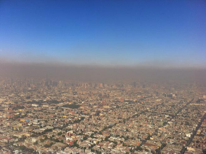
26 + VI. Environmental Problems B. Air pollution is a major problem in Mexico City, Mexico. 1. Temperature inversions caused by the surrounding landforms keep the air from mixing and it fills with pollution from factory and vehicle exhausts.
27 27
A funny sounding lake. South American Landforms, Climate, and Vegetation
 A funny sounding lake South American Landforms, Climate, and Vegetation 3 4 Essential Question: How have physical features and climate affected the population distribution of Latin America? 5 I. Landforms
STUDY GUIDE. The Land. Physical Features of Latin America. Chapter 8, Section 1. Terms to Know DRAWING FROM EXPERIENCE ORGANIZING YOUR THOUGHTS
 For use with textbook pages 193 198. The Land Terms to Know cordillera A mountain range that runs parallel to another mountain range (page 194) altiplano A high plain (page 194) escarpment A steep cliff
Latin America. Introduction
 Latin America Introduction What are the 5 Themes of Geography? Draw lines to connect the theme to the definition: Location How humans and the environment impact each other Physical and human characteristics
Latin America. Chapter 9 Physical Geography
 Latin America Chapter 9 Physical Geography Latin American Regions Middle America includes Mexico and the Central American countries The Caribbean Islands South America Mexico Landforms Sierra Madre Oriental
Latin America. Physical Geography
 Latin America Physical Geography Regions Latin America can be divided into separate regions based on physical geography or cultural geography. Regions If we look at physical geography Latin America has
World Geography Ch. 7.2 Climate Regions of Latin America
 World Geography Ch. 7.2 Climate Regions of Latin America BR: D10 When you think of Latin America, what types of climates do you think are down there? Write down which of the following you believe are there:
Objective. Students will familiarize themselves with the physical features and climates of Latin America.
 Journal Write KWL What do you KNOW about Latin America? What do you WANT TO KNOW about Latin America? What did you LEARN today that you didn t know before? Latin America Objective Students will familiarize
*Latin America spans 7,000 miles, from Mexico to Tierra Del Fuego. *3 Regions: Central America, South America, and the Caribbean.
 Physical Geography Latin America spans 7,000 miles, from Mexico to Tierra Del Fuego *3 Regions: Central America, South America, and the Caribbean. *Intro clip: http://www.youtube.com/watch?v=cffp6rza3
Latin America s Physical Geography. EQ: What are characteristics of Latin America s physical features?
 Latin America s Physical Geography EQ: What are characteristics of Latin America s physical features? Your Task: We are going to participate in a Museum Walk! You will travel around the room with a partner
Mrs. Reifsnyder World Geography. Unit 8: Latin America Study Guide SOLs Addressed: WG. 1c, 2b, 3c, 4, 10b/c
 Mrs. Reifsnyder World Geography Unit 8: Latin America Study Guide SOLs Addressed: WG. 1c, 2b, 3c, 4, 10b/c Essential Questions: - In what ways do physical, economic, and cultural characteristics influence
The Lesser Antilles. Dominican Republic), and Puerto Rico
, and Puerto Rico") The Caribbean Islands are archipelagoes or groups of islands. The major archipelagoes are: The Greater Antilles - Cuba, Jamaica, Hispaniola (Composed of Haiti and the Dominican Republic), and Puerto Rico
The Caribbean Islands are archipelagoes or groups of islands. The major archipelagoes are: The Greater Antilles - Cuba, Jamaica, Hispaniola (Composed of Haiti and the Dominican Republic), and Puerto Rico
Friday, November 10, 2017
 Friday, November 10, 2017 Andes and Midlatitude Countries Objective: Summarize the main physical features and regions of the Southern Cone. Identify and locate the urban centers and understand the pattern
CHAPTER 12. South America. Section 1: Natural Environments Section 2: History and Culture Section 3: South America Today. HOLT World Geography
 CHAPTER 12 South America Section 1: Natural Environments Section 2: History and Culture Section 3: South America 1 Section 1 Natural Environments Objectives: What are the major landforms and rivers of
Geographic Qualities of South America
 Geographic Qualities of South America 1. South America is the fourth largest continent in area. It is located in the Western Hemisphere, lying southwest of North America. Most of South America lies in
Essential Questions. 1. How have historical figures and events affected South America today?
 South America Essential Questions 1. How have historical figures and events affected South America today? 2. How has location affected the development of countries in South America? 3. How has the role
Latin America and The Caribbean. A Closer Look.
 Latin America and The Caribbean A Closer Look. Mexico Capital: Mexico City The Location of Mexico Mexico is the second-largest country by size and population in Latin America.but the Largest Spanish -
THE PHYSICAL AND CULTURAL GEOGRAPHY OF SOUTH AMERICA
 THE PHYSICAL AND CULTURAL GEOGRAPHY OF SOUTH AMERICA 1 Global location Relative to European capitals Relative to US cities Time zones Two oceans Pacific rim countries - farther to Asia than USA Not on
Regional Atlas: Introduction to Latin America
 Chapter 9, Section World Geography Chapter 9 Regional Atlas: Introduction to Latin America Copyright 2003 by Pearson Education, Inc., publishing as Prentice Hall, Upper Saddle River, NJ. All rights reserved.
South American Countries. Capital Location Population Terrain Climate
 South American Countries Capital Location Population Terrain Climate Andes Mountains Four large areas that make up the Central Plains: Llanos, the Selva, the Gran Chaco, and the Pampas Brazilian Highlands
WORLD GEOGRAPHY. Hector Rodriguez
 Mr. Chavira 9th Period WORLD GEOGRAPHY Hector Rodriguez P a g e 1 Table of Contents Latin America Page 2 o Maps Economic Map Page 3 Political Map Page 4 Population Map Page 5 Physical Page 6 o Notes Physical
LOCATION, CLIMATE, AND NATURAL RESOURCES OF MEXICO
 SS6G3 The student will explain the impact of location, climate, distribution of natural resources, and population distribution on Latin America and the Caribbean. a. Compare how the location, climate,
6th Grade Western Hemisphere Geography
 6th Grade Western Hemisphere Geography Multiple Choice Identify the choice that best completes the statement or answers the question. 1 Latin America is located in the A Northern Hemisphere. C Western
UNIT 3 Extra Review for Chapters 9-11
 UNIT 3 Extra Review for Chapters 9-11 Mexico Central America Caribbean Islands Middle America is Central America, Mexico, and the Islands of the Caribbean Central America is a region within Middle America.
Brain Wrinkles. Location, Climate, & Natural Resources of. Where People Live & How They Trade
 Location, Climate, & Natural Resources of Where People Live & How They Trade It s south of the US, east of the Pacific Ocean, and west of the Gulf of Mexico & Caribbean Sea. It s great that it s located
STANDARDS: Brain Wrinkles
 STANDARDS: SS6G3 The student will explain the impact of location, climate, distribution of natural resources, and population distribution on Latin America and the Caribbean. a. Compare how the location,
Chapter 19 Test on South America
 Name Part 1 - Labeling (27 pts.) Chapter 19 Test on South America Score A. Locate the countries and territory contained in the word box below on the map of South America on the next page. Write the name
LOCATION, LOCATION, LOCATION! Mexico, Venezuela, Cuba, and Brazil
 LOCATION, LOCATION, LOCATION! Mexico, Venezuela, Cuba, and Brazil GPS and E.Q. GPS: SS6G3 The student will explain the impact of location, climate, distribution of natural resources, and population distribution
LAST TIME (Happy 300 th Birthday Ben Franklin!)
") LAST TIME (Happy 300 th Birthday Ben Franklin!) Latin American Diversity: Introduction Physical Geography of Mexico, Caribbean, and Central America: 1. Mexican drylands 2. Mesoamerican Highlands 3. Coastal
LAST TIME (Happy 300 th Birthday Ben Franklin!) Latin American Diversity: Introduction Physical Geography of Mexico, Caribbean, and Central America: 1. Mexican drylands 2. Mesoamerican Highlands 3. Coastal
6th Grade Western Hemisphere Geography
 6th Grade Western Hemisphere Geography Multiple Choice Identify the choice that best completes the statement or answers the question. 1 Latin America is located in the A Northern Hemisphere. C Western
Why is the US industry and agriculture prosperous? The US industry and agriculture is so prosperous because it has many different natural resources.
 Ch. 1-7 Study Guide Why is the US industry and agriculture prosperous? The US industry and agriculture is so prosperous because it has many different natural resources. What likely drew immigrants to the
Name: Hour: Day: The Land and Its Regions (pg ) Define, in your own words, escarpment. Define, in your own words, sertão
 Define, in your own words, escarpment. Define, in your own words, sertão") Name: Hour: Day: World Geography Guided Reading Notes Chap 12 & 13 --- ANSWER IN COMPLETE SENTENCES!!!! READ EACH QUESTION CAREFULLY & ANSWER COMPLETELY!!!! Objectives: Upon completion of reading you should
Name: Hour: Day: World Geography Guided Reading Notes Chap 12 & 13 --- ANSWER IN COMPLETE SENTENCES!!!! READ EACH QUESTION CAREFULLY & ANSWER COMPLETELY!!!! Objectives: Upon completion of reading you should
1st Period Mr. Chavira WORLD GEOGRAPHY. Hector Rodriguez
 1st Period Mr. Chavira WORLD GEOGRAPHY Hector Rodriguez P a g e 1 Table of Contents Latin America Page 2 o Maps Economic Map Page 3 Political Map Page 4 Population Map Page 5 Physical Page 6 o Notes Physical
South America. pg. 520 (5 th) pg. 523 (6 th )
 pg. 523 (6 th )") South America pg. 520 (5 th) pg. 523 (6 th ) Venezuela Rich in Oil Lake Maracaibo Called Little Venice pg. 572 (5 th) pg. 574 (6 th ) Caracas 8 miles Inland 3000 pg. 572 (5 th) pg. 574 (6 th ) Caracas
South America pg. 520 (5 th) pg. 523 (6 th ) Venezuela Rich in Oil Lake Maracaibo Called Little Venice pg. 572 (5 th) pg. 574 (6 th ) Caracas 8 miles Inland 3000 pg. 572 (5 th) pg. 574 (6 th ) Caracas
UNIT 5 AFRICA PHYSICAL GEOGRAPHY SG 1 - PART II
 UNIT 5 AFRICA PHYSICAL GEOGRAPHY SG 1 - PART II III. CLIMATE & VEGETATION A. The four main climate zones are tropical wet, tropical wet/dry (split into monsoon & savanna), semiarid, and arid. Other climate
Comprehension Questions:
 Unit 3: Central & South america Comprehension Questions: 1. What is the driest desert on earth? Atacama Desert 2. What two water routes were discovered in the 1500s to get around the tip of South America?
Exploring South America Learning Lapbook with Study Guide
 A J T L Grades 1-4 Exploring South America Learning Lapbook with Study Guide A Journey Through Learning www.ajourneythroughlearning.com Copyright 2013 A Journey Through Learning 1 Authors-Paula Winget
GEOGRAPHY AND HISTORY
 GEOGRAPHY AND HISTORY YEAR 1, PART 1 www.vicensvives.es Contents 01 Our planet Earth 02 The representation of the Earth: maps 03 The Earth s relief 04 Rivers and seas 05 Weather and climate 06 Climates
Chapter 10 Study Guide SOUTH AMERICA
 Chapter 10 Study Guide SOUTH AMERICA When Spain and Portugal competed for trading lands in the New World, who came up with the line of demarcation to settle the dispute? The Caribbean Countries: Who was
South America. Land of Color and Contrast
 South America Land of Color and Contrast Home to: *The world s largest river system *The longest mountain chain, and second tallest mountains *Earth s driest desert *One of the world s great grassland
Mrs. Davis s Adventures
 Mrs. Davis s Adventures Latin America Countries & Political Map NAME: DATE: PERIOD: DIRECTIONS: Use your mapping skills and textbook pages: 127, 97, and 3 to complete Mrs. Davis s Story. Transfer the countries
The Northern Tropics
 The Northern Tropics The Guianas Countries Guyana, Suriname, French Guyana Culture reflects colonial history Official Languages Guyana English Suriname Dutch French Guyana - French Religions Suriname and
CHAPTER Latin America. Regional Atlas Study Guide. 2 Chapter A. As You Read. B. Reviewing Vocabulary
 CHAPTER 28 9 Many Th ew inventions new Regional Atlas Study Guide Latin America Directions: As you work through the Regional Atlas, complete the chart below by writing two details about each Latin American
Geography: Latin America (ch. 8, 9 and 10) page 1. p. 178: What areas make up Latin America? Mexico, Central Amer., Caribbean Islands, South America
 page 1. p. 178: What areas make up Latin America? Mexico, Central Amer., Caribbean Islands, South America") Geography: Latin America (ch. 8, 9 and 10) page 1 p. 178: What areas make up Latin America? Mexico, Central Amer., Caribbean Islands, South America Chapter 8: Physical Geography of Latin America I. The
Geography: Latin America (ch. 8, 9 and 10) page 1 p. 178: What areas make up Latin America? Mexico, Central Amer., Caribbean Islands, South America Chapter 8: Physical Geography of Latin America I. The
LATIN AMERICA. Mexico Central America Caribbean Islands South America
 LATIN AMERICA Mexico Central America Caribbean Islands South America HISTORY First Settlers Hunters/gatherers from Asia crossed land bridge connecting Asia and Alaska Learned to farm over time Maize (corn)
2.1 What is the climate like?
 José Medeiros This fact sheet allows you to see how varied the countryside is across Brazil. 2.1 What is the climate like? Most of Brazil is in the Southern Hemisphere, where the seasons are the opposite
South America: Physical Geography
 This website would like to remind you: Your browser (Apple Safari 4) is out of date. Update your browser for more security, comfort and the best experience on this site. Encyclopedic Entry South America:
Portuguese Language - Fostering National Unity
 Geography Brazil Brazil Portuguese Language - Fostering National Unity 11 dialects of Portuguese Influenced by Amerindian and African languages, creating differences between Portuguese spoken in Brazil
UNIT 5 PHYSICAL GEOGRAPHY SG 1 - PART I
 UNIT 5 PHYSICAL GEOGRAPHY SG 1 - PART I Africa is HUGE! I. LANDFORMS A. Plateaus - an area of relatively level high ground. 1. Africa s interior is dominated by series of plateaus and elevated basins such
Chapter Objectives. Describe the dominant landforms and natural resources of Southeast Asia. Discuss Southeast Asia s climate and vegetation.
 Chapter Objectives Describe the dominant landforms and natural resources of Southeast Asia. Discuss Southeast Asia s climate and vegetation. The Land Section 1 Objectives Describe how tectonic plates and
Chapter 20. The Physical Geography of Africa South of the Sahara
 Chapter 20 The Physical Geography of Africa South of the Sahara Chapter Objectives Identify the major landforms, water systems, and natural resources of Africa south of the Sahara. Describe the relationship
Do Not Write On This Sheet. World Rally. City, country, continient: to city, country, continent:
 World Rally At each checkpoint you must list the city, country, and continent. The teacher must check all answers before you can go on to the next checkpoint. Checkpoint 1: Start at: 29 N 98 W and go to:
U N I T 3 Latin America
 UN I T 3 Latin America Introducing the Region: Physical and Human Geography Chapter 9 Spatial Inequality in Mexico City: From Cardboard to Castles TCI5 428 GA_SE_ML_03-1.eps Cyan Magenta Yellow Black Second
Chapter 13: Life in the Central Andes- Adapting to a Mountainous Region
 Chapter 13: Life in the Central Andes- Adapting to a Mountainous Region 1. Introduction La Paz, Bolivia, is the highest big city in the world, sitting at 12,000 feet above sea level in the central Andes
EXPLORING BIOMES IN GORONGOSA NATIONAL PARK
 EXPLORING BIOMES IN GORONGOSA NATIONAL PARK ABOUT THIS WORKSHEET This worksheet complements the Click and Learn Gorongosa National Park Interactive Map (http://www.hhmi.org/biointeractive/gorongosa-national-park-interactive-map),
2018 Spring Semester Final : STUDY GUIDE
 Name: Hr: 2018 Spring Semester Final : STUDY GUIDE My final is on:, May My final will have questions and will be COLONIZATION OF NORTH & SOUTH AMERICA - Match the regions with the European countries that
Introduction to Africa
 Introduction to Africa Did you know? Africa has more countries than any other continent. The Sahara is a desert that is the size of the U.S. It s the world's largest desert. Most of the world s gold and
Latin America: Physical Geography
 Page 1 of 7 Latin America: Physical Geography TERMS & NAMES tributary deforestation Tropical Zone El Niño MAIN IDEA Latin America s landforms, bodies of water, and climate offer a wide range of environments
Brain Wrinkles. Africa: The impact of location, climate, & physical characteristics on where people live, the type of work they do, & how they travel
 Africa: The impact of location, climate, & physical characteristics on where people live, the type of work they do, & how they travel STANDARDS: SS7G3 The student will explain the impact of location, climate,
Just how big is Africa?
 The United States China India The United Kingdom Portugal Spain France Belgium Germany The Netherlands Switzerland Italy Eastern Europe Japan 11.7 million sq. miles Just how big is Africa? Chapter 18 Section
Introduction. We hope you find these materials useful and would welcome any feedback.
 Introduction This planning pack was produced with teachers from County Durham following a visit to São Paulo. The materials support the teaching of geography at key stage one and two within the context
Exploring Mexico. Directions: Complete the paragraphs below. Write the correct word from the Word Bank to complete each sentence.
 Exploring Mexico Section 1 10 Directions: Complete the paragraphs below. Write the correct word from the Word Bank to complete each sentence. Word Bank United States Central Plateau irrigation isthmus
3 rd Term Worksheet [ ] Subject Geography Class VI Name : Sec. :
![3 rd Term Worksheet [ ] Subject Geography Class VI Name : Sec. :](/thumbs/84/89736232.jpg "3 rd Term Worksheet [ ] Subject Geography Class VI Name : Sec. :") 1 geo (vi) 3 rd Term Worksheet [2018 19] Subject Geography Class VI Name : Sec. : Case Study 1 : The Lumberjacks of Canada Exercise: [80-81] [A] Choose the correct answers: [80] 1. What are the men who
1 geo (vi) 3 rd Term Worksheet [2018 19] Subject Geography Class VI Name : Sec. : Case Study 1 : The Lumberjacks of Canada Exercise: [80-81] [A] Choose the correct answers: [80] 1. What are the men who
Terms to Know. artesian well coral atoll krill lagoon
 Chapter Objectives Describe the diverse landforms and natural resources of Australia, Oceania, and Antarctica. Discuss the wide range of climates and vegetation throughout the region. The Land Section
STUDY GUIDE. The Land. Chapter 20, Section 1. The Land of Africa South of the Sahara. Landforms Water Systems Natural Resources.
 For use with textbook pages 499 504. The Land Terms to Know escarpment A steep, often jagged slope or cliff (page 500) cataract A towering waterfall (page 500) rift valley A large crack in the earth s
early human history and Central & South America Jeopardy
 early human history and Central & South America Jeopardy Every team will be chosen by Joe with the intention of mixing girls and boys and grade levels. Teams can choose a name if desired. teams can answer
The Geological Pacific Northwest. Wednesday February 6, 2012 Pacific Northwest History Mr. Rice
 The Geological Pacific Northwest Wednesday February 6, 2012 Pacific Northwest History Mr. Rice 1 Free Response #2 Please do not simply list the items for this response. Full sentences!!! Minimum of 3-5
Part 1: Physical Geography
 Part 1: Physical Geography Highlands Lowlands Wide range in elevation creates diverse climate zones in the region A mountain chain stretches along the western edge of the American continents for more
SS7G1 The student will locate selected features of Africa.
 Standards SS7G1 The student will locate selected features of Africa. a. Locate on a world and regional political-physical map: the Sahara, Sahel, savanna, tropical rain forest, Congo River, Niger River,
Good Morning! Pick up the country profile from the front table. Sit down QUIETLY. If I gave you a new seat
 Good Morning! Pick up the country profile from the front table. Sit down QUIETLY If I gave you a new seat Atlas Work 1. Which countries border Mexico? 2. What three bodies of water border Central and South
STUDY GUIDE. The Land. Chapter 29, Section 1. Both. Terms to Know DRAWING FROM EXPERIENCE ORGANIZING YOUR THOUGHTS
 Chapter 29, Section 1 For use with textbook pages 719 724. The Land Terms to Know cordilleras Parallel mountain ranges and plateaus (page 719) archipelago A group of islands (page 720) insular Relating
Oceania. Australia, New Zealand, and the Pacific Islands. Physical Geography. Where is Australia located?
 Oceania Australia, New Zealand, and the Pacific Islands Physical Geography Australia New Zealand Oceania Where is Australia located? Australia & Oceania are a group of islands located between Asia, Antarctica,
The Geography of Climate
 The Geography of Climate Objective for Today: Today we will examine ways that latitude and landforms influence climate The focus of our study will be the South American Continent in the Formal Region known
Chapter 17. North Africa, Southwest Asia and Central Asia
 Chapter 17 North Africa, Southwest Asia and Central Asia Chapter Objectives Describe the major landforms and natural resources of North Africa, Southwest Asia, and Central Asia. Discuss the climate and
1. Summarize the main physical features and regions of the Southern Cone.
 6.4 The Southern Cone L E A R N I N G O B J E C T I V E S 1. Summarize the main physical features and regions of the Southern Cone. 2. Identify and locate the urban centers and understand the pattern of
Chapter 14. The Physical Geography of Russia
 Chapter 14 The Physical Geography of Russia Chapter Objectives Identify the physical features and natural resources of Russia. Discuss the effects of Russia s climate and vegetation on life in the region.
Brazil. Chapter 12. Chapter 12, Section
 Chapter 12, Section World Geography Chapter 12 Brazil Copyright 2003 by Pearson Education, Inc., publishing as Prentice Hall, Upper Saddle River, NJ. All rights reserved. Chapter 12, Section World Geography
Chapter 6 South America
 Chapter 6 South America Identifying the Boundaries Europeans called the Western Hemisphere the New World. South America is the realm consisting of the southern portion of the New World. This realm includes
STATEMENT FROM THE NINTH SOUTHERN AFRICA REGIONAL CLIMATE OUTLOOK FORUM (SARCOF-9) HELD IN HARARE, ZIMBABWE FROM 7 8 SEPTEMBER 2005.
 HELD IN HARARE, ZIMBABWE FROM 7 8 SEPTEMBER 2005.") STATEMENT FROM THE NINTH SOUTHERN AFRICA REGIONAL CLIMATE OUTLOOK FORUM (SARCOF-9) HELD IN HARARE, ZIMBABWE FROM 7 8 SEPTEMBER 2005. 1.0 SUMMARY During the period October to December 2005, northern DRC
STATEMENT FROM THE NINTH SOUTHERN AFRICA REGIONAL CLIMATE OUTLOOK FORUM (SARCOF-9) HELD IN HARARE, ZIMBABWE FROM 7 8 SEPTEMBER 2005. 1.0 SUMMARY During the period October to December 2005, northern DRC
Month June 2011 South America (except Colombia for HA) Date of submission 01/07/11 MONTHLY REPORT
 Date of submission 01/07/11 MONTHLY REPORT") ANNEX IV-3 EUROPEAN COMMISSION HUMANITARIAN AID OFFICE (ECHO) Monthly report number 2011/6 Month June 2011 Country South America (except Colombia for HA) Date of submission 01/07/11 Author ECHO Quito MONTHLY
ANNEX IV-3 EUROPEAN COMMISSION HUMANITARIAN AID OFFICE (ECHO) Monthly report number 2011/6 Month June 2011 Country South America (except Colombia for HA) Date of submission 01/07/11 Author ECHO Quito MONTHLY
Continents-South America 6/7/05 1:37 PM Page 1 Erinn Banting
 Erinn Banting Published by Weigl Publishers Inc. 350 5 th Avenue, Suite 3304, PMB 6G New York, NY 10118-0069 USA Web site: www.weigl.com Copyright 2006 WEIGL PUBLISHERS INC. All rights reserved. No part
Social Studies: The World
 Social Studies: The World What is the name of the continent that is labeled #1 on the map? North America What is the name of the continent that is labeled #2 on the map? South America What is the name
The Coasts Of Chile, Bolivia, And Peru By Anon
 The Coasts Of Chile, Bolivia, And Peru By Anon If you are searching for a book by Anon The Coasts of Chile, Bolivia, and Peru in pdf format, then you have come on to the faithful site. We furnish full
THE ARGENTINE REPUBLIC
 THE ARGENTINE REPUBLIC The name is derived from the Latin argentum (silver). The first use of the name Argentina can be traced to the voyages of the Spanish conquerors to the Río de la Plata. The explorers
CH. 1 Europe and Russia: Physical Geography. Section 1 Land and Water p Europe and Russia are part of the world s largest landmass called.
 CH. 1 Europe and Russia: Physical Geography Section 1 Land and Water p.10-16 Europe and Russia are part of the world s largest landmass called. The country of Russia stretches over both continents. About
Brazil Today The Amazon River and Basin
 Non-fiction: Brazil Today The Amazon River and Basin Brazil Today The Amazon River and Basin Deep within the Andes Mountains of northern Peru, two rivers flow together. Their junction forms one of the
GEOGRAPHY OF THE WESTERN HEMISPHERE
 GEOGRAPHY OF THE WESTERN HEMISPHERE LEARNING LOG Write clear directions that describe how to get from one place to another. Choose 2 locations that other people might not know about. Did you use a map
Australia. Geography
 Australia Geography Label the Map!!! New South Wales New South Wales Location: State on the east coast of Australia. Australian Capital Territory - Sydney! (5th largest, 1st most populous) Climate Types:
What Is An Ecoregion?
 Ecoregions of Texas What Is An Ecoregion? Ecoregion a major ecosystem with distinctive geography, characteristic plants and animals, and ecosystems that receives uniform solar radiation and moisture Sometimes
MT - GEOGRAPHY - (73) - SEMI PRELIM - I : PAPER - 6
 - SEMI PRELIM - I : PAPER - 6") 08 00 MT MT - GEOGRAPHY - (73) - SEMI PRELIM - I : PAPER - 6 Time : Hours (Model Answer Paper) Max. Marks : 0 Q.. Fill in the blank choosing the correct alternative : (a) In India, there has been a slight
08 00 MT MT - GEOGRAPHY - (73) - SEMI PRELIM - I : PAPER - 6 Time : Hours (Model Answer Paper) Max. Marks : 0 Q.. Fill in the blank choosing the correct alternative : (a) In India, there has been a slight
AFRICAN PHYSICAL GEOGRAPHY
 AFRICAN PHYSICAL GEOGRAPHY Here are some factoids about Africa: world s second largest continent (11,700,000 miles). Home to 52 countries, 1,000 languages, 800 million people. 10% of the world s population
Unit 5: Latin America Today
 Unit 5: Latin America Today In this unit, you will turn your attention to Latin America. You will study the geography of some Latin American countries. You will learn about their history, politics, revolutions,
September. ECHO Quito team MONTHLY REPORT
 EUROPEAN COMMISSION HUMANITARIAN AID OFFICE (ECHO) Monthly report number 2012/09 Month Country September South America (except Colombia for HA) Date of submission 04/10/12 Author ECHO Quito team 1. SUMMARY
The nation of Argentina is located in South America and covers more than one
 Argentina Location The nation of Argentina is located in South America and covers more than one million square acres. It is the second largest nation in Latin America, only being exceeded by Brazil in
Lesson 1: Land and Climate of the West Land and Water of the West 1. There are 13 states in the West, divided into 3 regions a. Southwest: Nevada,
 Lesson 1: Land and Climate of the West Land and Water of the West 1. There are 13 states in the West, divided into 3 regions a. Southwest: Nevada, Utah, Arizona, New Mexico b. Mountain States: Wyoming,
Chapter 6: South America
 Chapter 6: South America Identifying the Boundaries Europeans called the Western Hemisphere the New World. South America is the realm consisting of the southern portion of the New World. This realm includes
Latin America 11/4/2013. Latin America Today. 580 million people 9% of the world s population Diverse backgrounds:
 Latin America Chapter 10 Human Geography Latin America Today 580 million people 9% of the world s population Diverse backgrounds: Native Americans Europeans Africans Asians 1 Population 393 million live
CARIBBEAN ISLANDS 260,671 km 2
 The Bahamas Havana Cuba Camaguey Santiago de Cuba Dominican Republic Santiago Port-au-Prince San Juan Mexico Jamaica Kingston Haiti Santo Domingo Puerto Rico Venezuela CARIBBEAN ISLANDS 260,671 km 2 BIODIVERSITY
Unit 5/Chapter 8 ticket Central America and the Caribbean
 Unit 5/Chapter 8 ticket Central America and the Caribbean Important Vocabulary Latifundia inifundia ISTHMUS : a strip of land two large strips of land ARCHIPELAGO : a or of islands BIODIVERSITY : an as
South America Projects
 South America Projects Study the geography of South America by choosing one of the activities below. South American Travel Brochure Explorer s Journal World Cup Geography Create a Playable Board Game Create
Label your Map with Russia. Map Activity
 Bell Activity How many time zones does the U.S. have? How do these time zones affect life in the U.S.? Russia is so large it has 11 time zones. What difficulties might this create? Objectives Know landforms,