Location, Climate, & Natural Resources
|
|
|
- Pearl McBride
- 6 years ago
- Views:
Transcription

1 Location, Climate, & Natural Resources


2

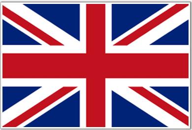
3 UK is a country of islands off the coast of mainland Europe. It consists of England, Northern Ireland, Scotland, & Wales.
4 UK s location makes it a HUB for trade. --Across the English Channel is France, west is the Republic of Ireland, east is the Scandinavian Peninsula --There are 10 major ports along UK s coast!
5 Location has helped the UK become an international banking & insurance center. UK has more foreign bank branches than any country in the world Location on the Atlantic Ocean helps it trade with the US. The US is the UK s #1 trading partner.

6 UK has a mild climate with abundant rainfall throughout the year. No section goes without rain for more than 2 weeks! Winters are mild and wet; summers are warmest in the south. The Gulf Stream crosses the Atlantic Ocean & warms the country, making the winters milder
7
8 UK has deposits of coal, petroleum, natural gas, & iron ore. These form the backbone of the country s industry: auto production, steel manufacturing, & shipbuilding. Other resources include: zinc, lead, gold, tin, limestone, salt, clay, gypsum, potash, sand,
9 Manufacturing is declining Natural resources are being used up and industry is changing to cleaner forms of energy. --Many people who once had jobs in mining and manufacturing are being retrained for jobs in service industries --80% of the people work in service industries (tourism, health care, education, banking, &
10 Fishing is profitable along the shores of the UK. Nearly 25% of the country has arable land (fertile; good for farming). --Over half of the land is used for farms.
11 About 60 million people live in the United Kingdom. Land Area: 243,610 sq km Around 90% of the UK s people live in cities. --London alone has over 7 million people!

12
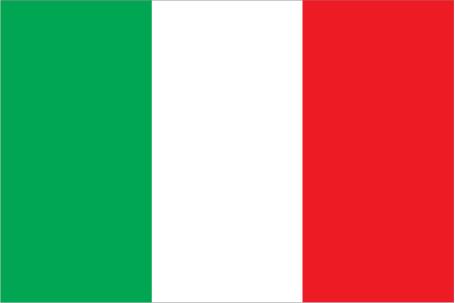
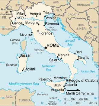
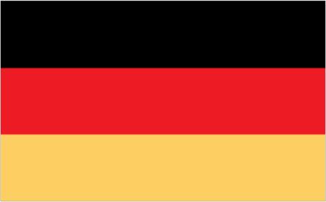
13 Italy is a long, boot-shaped peninsula surrounded on 3 sides by the Mediterranean Sea. The Alps form Italy s northern border. The Apennine Mountains run from the Alps to the sea. Two islands, Sardinia & Sicily, are part of

14
15 Italy has a temperate (mild) climate with regional differences. The coastal areas have mild winters and warm, dry summers. Mountains have cold, wet, and snowy winters and humid summers.
16 Italy has few mineral resources: natural gas, marble, granite, coal, mercury, zinc, and potash. Arable land is important (26% fertile land). Small farms cover much of the country.
17 Population: 58,000,000 Land Area: 301,340 sq km 7 out of 10 Italians live in urban areas (Rome, Naples, Milan, & Turin) About half of the people live in the most northern 1/3 rd of the country!
18 Apennine Mountains are like a backbone across Italy. They affect where people live & how they transport people and goods. Italy s location on the Mediterranean Sea affects trade with other countries. Italy has a long history of shipping goods to countries in Africa, Europe, & Asia.

19

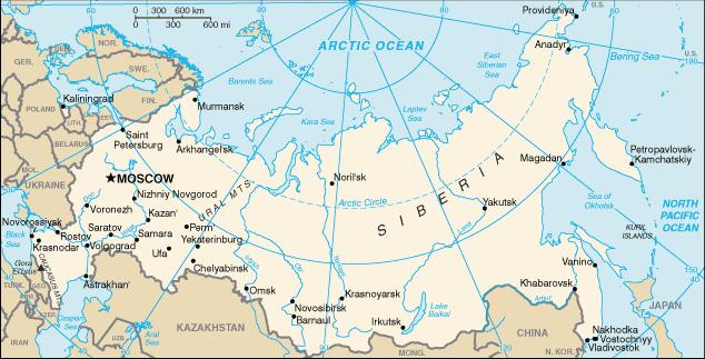
20 Germany is in north-central Europe on the European Plain. The southern region is mountainous; the central region is hilly and mountainous; the northern region is flat plains. Germany contains the most important commercial waterway in Europe (Rhine

21
22 Most of Germany has a mild, marine climate. In the west, winters are mild and summers are cool, with rainfall year round. The Gulf Stream warms the region, making the land warmer in the winter and cooling it off in the summer. In the east, winters are very cold, while
23 Germany has many natural resources: iron ore, coal, potash, uranium, nickel, natural gas, & copper. Timber is also a resource, but much of the forests in the north have been cut down for farms & towns. About 33% of the land is arable.
24 Population: 82,000,000 Land Area: 357,022 sq km Germany is one of the most densely populated countries in Europe 85% of the population lives in urban areas (cities) Berlin is the largest city & the capital

25 Rhine River is very important for trade. Many German cities lie along the Rhine. Location gives those cities an excellent way to transport


26
27 Russia spans 2 continents: Europe & Asia. It is so wide that a train trip across takes a week! Russia shares a border with 15 countries. The eastern side is bounded by Pacific Ocean, and the northern side is bounded by Arctic Ocean. At its closest point, Russia & US are only
28 European Russia is mostly landlocked (difficult for trading via ship), 2 exceptions: Murmansk & St. Petersburg
29
30 Russia only has 2 seasons winter and summer. The average yearly temperature is below freezing! Asian Russia (Siberia) has the most extreme climate: lows -40 degrees & highs over 90
31 Vast forests for lumber are found here, but many have been cleared away for cities on the European side. Deposits of gold, aluminum ore, coal, & iron are found in the Ural Mountains. Volga River (largest river in Europe) is a major source of hydroelectric power.

32 Russia s large size, rugged terrain, and cold climate make it difficult for Russians to use their resources.
33 Russia is one of the most populous countries in the world, with million people. Land Area: 17,098,242 sq km Most people live WEST of the Ural mountains, where the climate is mildest and the land is the most fertile.
Location, Climate, & Natural Resources Brain Wrinkles
 Location, Climate, & Natural Resources Standards SS6G10 The student will explain the impact of location, climate, natural resources, and population distribution on Europe. a. Compare how the location,
CH. 1 Europe and Russia: Physical Geography. Section 1 Land and Water p Europe and Russia are part of the world s largest landmass called.
 CH. 1 Europe and Russia: Physical Geography Section 1 Land and Water p.10-16 Europe and Russia are part of the world s largest landmass called. The country of Russia stretches over both continents. About
Europe. World Geography
 Europe World Geography Physical Geography Europe s landforms also include large plains and mountain ranges. Europe is composed of many peninsulas and islands. Always near Water Europe is a large peninsula
Latin America and The Caribbean. A Closer Look.
 Latin America and The Caribbean A Closer Look. Mexico Capital: Mexico City The Location of Mexico Mexico is the second-largest country by size and population in Latin America.but the Largest Spanish -
Label your Map with Russia. Map Activity
 Bell Activity How many time zones does the U.S. have? How do these time zones affect life in the U.S.? Russia is so large it has 11 time zones. What difficulties might this create? Objectives Know landforms,
Chapter 14. The Physical Geography of Russia
 Chapter 14 The Physical Geography of Russia Chapter Objectives Identify the physical features and natural resources of Russia. Discuss the effects of Russia s climate and vegetation on life in the region.
LOCATION, CLIMATE, AND NATURAL RESOURCES OF MEXICO
 SS6G3 The student will explain the impact of location, climate, distribution of natural resources, and population distribution on Latin America and the Caribbean. a. Compare how the location, climate,
Physical Geography of Europe. Chapters 13-18
 Physical Geography of Europe Chapters 13-18 The British Isles Archipelago made of 6000+ small islands Temperate climate Largest body of fresh water is Loch Ness Mostly rolling hills and large flat lands
Monday, December 11, 2017
 Monday, December 11, 2017 Physical Geography of Russia Objective: complete Warm-Up, write outline notes and discuss the geography of Eastern Europe/mother Russia and view Geography Now: Belarus. География
Do Not Write On This Sheet. World Rally. City, country, continient: to city, country, continent:
 World Rally At each checkpoint you must list the city, country, and continent. The teacher must check all answers before you can go on to the next checkpoint. Checkpoint 1: Start at: 29 N 98 W and go to:
Friday, November 10, 2017
 Friday, November 10, 2017 Andes and Midlatitude Countries Objective: Summarize the main physical features and regions of the Southern Cone. Identify and locate the urban centers and understand the pattern
MCGRAW-HILL EUROPE. Chapter 11 Physical Geography Pages 332 to 341
 MCGRAW-HILL EUROPE Chapter 11 Physical Geography Pages 332 to 341 Countries of Western Europe Benelux Countries UK, France, Luxembourg, Germany, Netherlands, Belgium, Austria, Switzerland, Belgium, Monaco,
Chapter Objectives. Describe the dominant landforms and natural resources of Southeast Asia. Discuss Southeast Asia s climate and vegetation.
 Chapter Objectives Describe the dominant landforms and natural resources of Southeast Asia. Discuss Southeast Asia s climate and vegetation. The Land Section 1 Objectives Describe how tectonic plates and
Economy 3. This region s economy was based on agriculture. 4. This region produced items such as textiles, iron, and ships in great quantities. For th
 Geography 1. This region has a climate of warm summers and snowy cold winters. 2. This region has a climate that is generally warm and sunny, with long, hot, humid summers, and mild winters, and heavy
Ms. Susan M. Pojer Horace Greeley HS Chappaqua, NY
 Ms. Susan M. Pojer Horace Greeley HS Chappaqua, NY Europe as a Queen Munster, 1588 Europe s s Latitude v. US Former Soviet Region Compared in Latitude & Area with the United States Satellite View of Europe
Australia. Geography
 Australia Geography Label the Map!!! New South Wales New South Wales Location: State on the east coast of Australia. Australian Capital Territory - Sydney! (5th largest, 1st most populous) Climate Types:
Latin America. Chapter 9 Physical Geography
 Latin America Chapter 9 Physical Geography Latin American Regions Middle America includes Mexico and the Central American countries The Caribbean Islands South America Mexico Landforms Sierra Madre Oriental
Brain Wrinkles. Location, Climate, & Natural Resources of. Where People Live & How They Trade
 Location, Climate, & Natural Resources of Where People Live & How They Trade It s south of the US, east of the Pacific Ocean, and west of the Gulf of Mexico & Caribbean Sea. It s great that it s located
2015 Brain Wrinkles. SS8G1b
 SS8G1b Georgia is a geographically diverse state that is divided into five regions. The first three regions (Appalachian Plateau, Valley and Ridge, and Blue Ridge) are in the mountains and foothills of
STANDARDS: Brain Wrinkles
 STANDARDS: SS6G3 The student will explain the impact of location, climate, distribution of natural resources, and population distribution on Latin America and the Caribbean. a. Compare how the location,
Chapter 11 Study Guide Western Europe
 Chapter 11 Study Guide Western Europe I. Northern Europe: Consists of and A. United Kingdom (Constitutional Monarchy and has political divisions) *, and make up the island known as Great Britain, while
Location, Climate, & Natural Resources. Where People Live & How They Trade
 Location, Climate, & Natural Resources Where People Live & How They Trade Standards SS6G13 The student will explain the impact of location, climate, distribution of natural resources, and population distribution
NAME: SURNAME: DATE: PHOTOQUIZ 1 EXERCISE. Photo 1: Answer A: France. Photo 2: Answer B: United Kingdom. Photo 3: Answer C: Portugal
 NAME: SURNAME: DATE: ID STUDENT: 001 ID EXERCISE:001 PHOTOQUIZ 1 EXERCISE Course: GEOGRAPHY Chapter: FLAGS PHOTO TITLE Photo 1: Answer A: France Photo 2: Answer B: United Kingdom Photo 3: Answer C: Portugal
Relative Location. originally in the today outdated today centered in population center closet to Channel Tunnel.
 NAME PERIOD LOCATION OF INDUSTRIAL REGIONS AROUND THE WORLD DIRECTIONS: Complete the following chart using Chapter 11 Key Issue # 1 in your textbook. Describe the relative location of each region and the
Terms to Know. artesian well coral atoll krill lagoon
 Chapter Objectives Describe the diverse landforms and natural resources of Australia, Oceania, and Antarctica. Discuss the wide range of climates and vegetation throughout the region. The Land Section
STUDY GUIDE. The Land. Chapter 29, Section 1. Both. Terms to Know DRAWING FROM EXPERIENCE ORGANIZING YOUR THOUGHTS
 Chapter 29, Section 1 For use with textbook pages 719 724. The Land Terms to Know cordilleras Parallel mountain ranges and plateaus (page 719) archipelago A group of islands (page 720) insular Relating
SS8G1 The student will describe Georgia with regard to physical features and location.
 SS8G1ab Standards SS8G1 The student will describe Georgia with regard to physical features and location. a. Locate Georgia in relation to the region, nation, continent, and hemispheres. b. Describe the
Chapter 5 Test British Isles 1
 Name Score Chapter 5 Test British Isles Part 1 Labeling (28 pts.) A. (9pts.) Locate the countries and other major political features contained in the word box below on the map of the British Isles on the
CHAPTER 12. South America. Section 1: Natural Environments Section 2: History and Culture Section 3: South America Today. HOLT World Geography
 CHAPTER 12 South America Section 1: Natural Environments Section 2: History and Culture Section 3: South America 1 Section 1 Natural Environments Objectives: What are the major landforms and rivers of
Italy (Italia in Italian) is located in southern Europe. In red on the map below, it sticks out into the Mediterranean Sea like a boot.
 is located in southern Europe. In red on the map below, it sticks out into the Mediterranean Sea like a boot.") ITALY Italy (Italia in Italian) is located in southern Europe. In red on the map below, it sticks out into the Mediterranean Sea like a boot. The island of Sicily is part of Italy. It is the piece that
ITALY Italy (Italia in Italian) is located in southern Europe. In red on the map below, it sticks out into the Mediterranean Sea like a boot. The island of Sicily is part of Italy. It is the piece that
!!!!!!!!!!Mali s Geographic Makeup
 DANU Strategic Forecasting Group May 27th 2016!!!!!!!!!!Mali s Geographic Makeup By Liliana Pirlea Location: Mali is a landlocked country located in West Africa. Mali is the 8th largest country in Africa
Oceania. Australia, New Zealand, and the Pacific Islands. Physical Geography. Where is Australia located?
 Oceania Australia, New Zealand, and the Pacific Islands Physical Geography Australia New Zealand Oceania Where is Australia located? Australia & Oceania are a group of islands located between Asia, Antarctica,
Chapter 20. The Physical Geography of Africa South of the Sahara
 Chapter 20 The Physical Geography of Africa South of the Sahara Chapter Objectives Identify the major landforms, water systems, and natural resources of Africa south of the Sahara. Describe the relationship
Chapter 17. North Africa, Southwest Asia and Central Asia
 Chapter 17 North Africa, Southwest Asia and Central Asia Chapter Objectives Describe the major landforms and natural resources of North Africa, Southwest Asia, and Central Asia. Discuss the climate and
Mediterranean Europe
 Chapter 17, Section World Geography Chapter 17 Mediterranean Europe Copyright 2003 by Pearson Education, Inc., publishing as Prentice Hall, Upper Saddle River, NJ. All rights reserved. Chapter 17, Section
European Countries. Central Europe (11) Germany Czech Republic Poland Estonia Latvia Lithuania Austria Switzerland Hungary Slovakia Liechenstein
 Germany Czech Republic Poland Estonia Latvia Lithuania Austria Switzerland Hungary Slovakia Liechenstein") European Countries North/ West Europe (11) Ireland UK France Sweden Finland Denmark The Netherlands Belgium Luxembourg Iceland Monaco Central Europe (11) Germany Czech Republic Poland Estonia Latvia Lithuania
European Countries North/ West Europe (11) Ireland UK France Sweden Finland Denmark The Netherlands Belgium Luxembourg Iceland Monaco Central Europe (11) Germany Czech Republic Poland Estonia Latvia Lithuania
Just how big is Africa?
 The United States China India The United Kingdom Portugal Spain France Belgium Germany The Netherlands Switzerland Italy Eastern Europe Japan 11.7 million sq. miles Just how big is Africa? Chapter 18 Section
Mexico. Chapter 10. Chapter 10, Section
 Chapter 10, Section World Geography Chapter 10 Mexico Copyright 2003 by Pearson Education, Inc., publishing as Prentice Hall, Upper Saddle River, NJ. All rights reserved. Chapter 10, Section World Geography
Chapter 16 ~ Eastern Mediterranean
 Chapter 16 ~ Eastern Mediterranean Physical Geography of the Eastern Mediterranean Landforms This area is known as the Levant and includes Syria, Jordan, Lebanon, Israel, and the Palestinian territories.
Chapter 16 ~ Eastern Mediterranean
 Chapter 16 ~ Eastern Mediterranean Physical Geography of the Eastern Mediterranean Landforms This area is known as the Levant and includes Syria, Jordan, Lebanon, Israel, and the Palestinian territories.
Information about the region
 13-16 February 2018 Information about the region In Brief Siberian Federal District (SFD) federal district in the Siberian part of Russia. It was created by presidential decree on May 13, 2000. The SFD
Essential Questions. 1. How have historical figures and events affected South America today?
 South America Essential Questions 1. How have historical figures and events affected South America today? 2. How has location affected the development of countries in South America? 3. How has the role
A funny sounding lake. South American Landforms, Climate, and Vegetation
 A funny sounding lake South American Landforms, Climate, and Vegetation 3 4 Essential Question: How have physical features and climate affected the population distribution of Latin America? 5 I. Landforms
South American Countries. Capital Location Population Terrain Climate
 South American Countries Capital Location Population Terrain Climate Andes Mountains Four large areas that make up the Central Plains: Llanos, the Selva, the Gran Chaco, and the Pampas Brazilian Highlands
Chapter 13 Eastern Europe & Western Russia: Recovering from war, communism, genocide, and unfortunate geography (Pg )
") Chapter 13 Eastern Europe & Western Russia: Recovering from war, communism, genocide, and unfortunate geography (Pg. 393-420) Lesson 1: Physical Geography of Eastern Europe & Western Russia Pg. 396-401
Chapter 13 Eastern Europe & Western Russia: Recovering from war, communism, genocide, and unfortunate geography (Pg. 393-420) Lesson 1: Physical Geography of Eastern Europe & Western Russia Pg. 396-401
Varied Lands and Varied Resources Chapter 9 Lesson 1
 Varied Lands and Varied Resources Chapter 9 Lesson 1 16 independent countries make up region of Europe From in north to Balkan Peninsula in south Eastern Europe four separate sub regions Western Balkans
DENMARK. CHAPTER TWELVE Section Two. DENMARK and ICELAND DENICE. Greenland too!
 CHAPTER TWELVE Section Two and ICELAND DENICE Greenland too! KEY QUESTION The success of Denmark can be traced to its' relationship with Europe. Explain Population: 5,325,000 Size: 16,638 sq. miles
2015 Brain Wrinkles. SS8G1b
 SS8G1b Standards SS8G1 The student will describe Georgia with regard to physical features and location. b. Describe the five geographic regions of Georgia; include the Blue Ridge Mountains, Valley and
6th Grade Social Studies Chapter 7: The Geography and Early Settlement of Egypt, Kush and Canaan
 I. Introduction (7.1) A. Egyptians settled along the Nile River, in the NE corner of Africa B. civilization lasted from around 3100 B.C. to 350 C. E. C. Kushites settled to the south of Egypt, along the
STUDY GUIDE. The Land. Chapter 17, Section 1. There are frequent earthquakes in the region. Petroleum is a major export in the region.
 For use with textbook pages 421 426. The Land Terms to Know alluvial soil A rich soil made up of sand and mud deposited by flowing water (page 423) wadi A streambed that remains dry until a heavy rain
Geography: Unit 2. Map. Rivers. Major Physical Features. Slide 1. Slide 2. Slide 3. Slide 4. North America United States and Canada.
 Mississippi River Slide 1 Slide 2 Slide 3 Slide 4 Geography: Unit 2 North America United States Map Major Physical Features Mountain Ranges Brooks Range Mackenzie Mountains Coast Mountains Cascades Sierra
Portuguese Language - Fostering National Unity
 Geography Brazil Brazil Portuguese Language - Fostering National Unity 11 dialects of Portuguese Influenced by Amerindian and African languages, creating differences between Portuguese spoken in Brazil
Spain Series 1 Secondary (7-12)
") Spain Series 1 Secondary (7-12) TABLE OF C ONTENTS Why Study Cultures?...................................... 2 Traditions The Running of the Bulls and San Fermin................... 3 Folklore & Language
Spain Series 1 Secondary (7-12) TABLE OF C ONTENTS Why Study Cultures?...................................... 2 Traditions The Running of the Bulls and San Fermin................... 3 Folklore & Language
What Peninsula is this?
 Map Review What Peninsula is this? The Arabian Peninsula What Peninsula is this? The Balkan Peninsula What Peninsula is this? The Iberian Peninsula What Peninsula is this? The Yucatan Peninsula Which trade
STUDY GUIDE. The Land. Physical Features of Latin America. Chapter 8, Section 1. Terms to Know DRAWING FROM EXPERIENCE ORGANIZING YOUR THOUGHTS
 For use with textbook pages 193 198. The Land Terms to Know cordillera A mountain range that runs parallel to another mountain range (page 194) altiplano A high plain (page 194) escarpment A steep cliff
What Is An Ecoregion?
 Ecoregions of Texas What Is An Ecoregion? Ecoregion a major ecosystem with distinctive geography, characteristic plants and animals, and ecosystems that receives uniform solar radiation and moisture Sometimes
countries include the Republic of Benin, Chad. Cameroon, and Niger. These countries surround
 Nigeria Location Nigeria is located in West Africa and it shares land borders with a few countries. These countries include the Republic of Benin, Chad. Cameroon, and Niger. These countries surround Nigeria
CANADA: ITS LAND, RESOURCES, & ECONOMY PRE-TEST
 PRE-TEST Name Directions: In the blank space, write a "T" if the statement is true and an "F" if the statement is false. 1. Canada has 11 geographic regions. 2. The cordillera is found in central Canada.
Brain Wrinkles. Africa: The impact of location, climate, & physical characteristics on where people live, the type of work they do, & how they travel
 Africa: The impact of location, climate, & physical characteristics on where people live, the type of work they do, & how they travel STANDARDS: SS7G3 The student will explain the impact of location, climate,
Chapter 15: RUSSIA & The REPUBLICS
 Chapter 15: RUSSIA & The REPUBLICS Ch. 15:1 Landforms & Resources The Northern European Plain stretches for over 1,000 miles between the western border of Russia & the Republics and the. Ural Mountains
Geography: Unit 2. Map. Major Physical Features. Rivers. Mississippi River Missouri River Ohio River Rio Grande. Mackenzie. Colorado River Green River
 1 2 3 4 Geography: Unit 2 North America United States and Canada Map Major Physical Features Mountain Ranges Brooks Range Mackenzie Mountains Coast Mountains Cascades Sierra Nevada Rocky Mountains Appalachian
Section 1: Physical Geography Section 2: Greece Section 3: Italy Section 4: Spain and Portugal
 CHAPTER 18 Southern Europe Section 1: Physical Geography Section 2: Greece Section 3: Italy Section 4: Spain and Portugal 1 2 3 Section 1 Physical Geography Major Landforms of Southern Europe: The Iberian
Europe is the second smallest continent by land size. It is made up of over 50 countries and has a wide variety of climate and geographical features.
 Europe is the second smallest continent by land size. It is made up of over 50 countries and has a wide variety of climate and geographical features. ORAL DISCUSSION Think about what you already know about
Physical Regions of the U.S.
 Physical Regions of the U.S. Quickly use this map to label the map on your paper Pacific Coast The coast from southern California to Alaska The region of the Pacific Northwest has a long history that was
Year 7 Geography Snow Work
 Year 7 Geography Snow Work As part of your ISEB Geography Syllabus, you are required to know the names and locations of major countries, capitals, mountain ranges and rivers in the UK, Europe and throughout
GEOGRAPHY AND HISTORY
 GEOGRAPHY AND HISTORY YEAR 1, PART 1 www.vicensvives.es Contents 01 Our planet Earth 02 The representation of the Earth: maps 03 The Earth s relief 04 Rivers and seas 05 Weather and climate 06 Climates
Match the names below with their locations on the map by writing the correct letter in the blank.
 P r e v i e w Match the names below with their locations on the map by writing the correct letter in the blank. Physical Features of Canada 60ºN 70ºN 80ºN A R C T I C O C E A N 130ºW 120ºW 110ºW 90ºW 70ºW
UNIT 5 PHYSICAL GEOGRAPHY SG 1 - PART I
 UNIT 5 PHYSICAL GEOGRAPHY SG 1 - PART I Africa is HUGE! I. LANDFORMS A. Plateaus - an area of relatively level high ground. 1. Africa s interior is dominated by series of plateaus and elevated basins such
COUNTRY DATA: BRAZIL: Information from the CIA World Factbook INTRODUCTION
 COUNTRY DATA: BRAZIL: Information from the CIA World Factbook INTRODUCTION Following more than three centuries under Portuguese rule, Brazil gained its independence in 1822, maintaining a monarchical system
Read and Respond: Australia
 Read and Respond: Australia Directions: Highlight the answers to the following questions and write them out in complete sentences on your own sheet of paper. GEOGRAPHY OF AUSTRALIA The best way to visualize
Unit 5: Latin America Today
 Unit 5: Latin America Today In this unit, you will turn your attention to Latin America. You will study the geography of some Latin American countries. You will learn about their history, politics, revolutions,
Subject: Social Studies
 SY 2018/2019 1 st Final Term Revision Student s Name: Grade: 6A/B Subject: Social Studies Teacher Signature Worksheets in Social Studies 6 Unit 2 Lesson 3 World Seas pages 37-40 WB. Pp. 22-25 Lesson 4
Region 1 Piney Woods
 Region 1 Piney Woods Piney Woods 1. This ecoregion is found in East Texas. 2. Climate: average annual rainfall of 36 to 50 inches is fairly uniformly distributed throughout the year, and humidity and temperatures
The Geological Pacific Northwest. Wednesday February 6, 2012 Pacific Northwest History Mr. Rice
 The Geological Pacific Northwest Wednesday February 6, 2012 Pacific Northwest History Mr. Rice 1 Free Response #2 Please do not simply list the items for this response. Full sentences!!! Minimum of 3-5
The Maltese Islands: Geography
 The Maltese Islands: Geography The Maltese Archipelago comprises a group of small low islands aligned in a NW-SE direction. At their extreme points the Maltese Islands fall within the following points:
Prague Tourism Developments in Q1 2018
 Prague Tourism Developments in Q1 2018 Facts and Figures: Total visitors: 1,499,044 foreign: 1,239,848 (82.7%) domestic: 259,196 (17.3%) Total visitor growth in Prague: 121,224 visitors (8.8%) foreign
Chapter 3. The English Colonies
 Chapter 3 The English Colonies Terms 1. Indentured servants 2. Cash crops 3. Assembly 4. Puritans 5. Mayflower Compact 6. Slave trade 7. Fundamental orders Massachusetts- 1630 Founders- William Bradford
Chapter 1 Test A (1 of 5)
") Chapter 1 Test A (1 of 5) Vocabulary Match the descriptions with the correct terms. (8 points) Column I 1. a natural feature of Earth s surface 2. something in the environment that people use 3. the pattern
Chapter 1 Test A (1 of 5) Vocabulary Match the descriptions with the correct terms. (8 points) Column I 1. a natural feature of Earth s surface 2. something in the environment that people use 3. the pattern
Rivers of the World. The Nile. The Rhine
 The Nile The Nile is traditionally considered to be the longest river in the world. It is 4132 miles (6650 km) long that s nearly seven times the distance from John o Groats at the top of Scotland to Land
LOCATION, LOCATION, LOCATION! Mexico, Venezuela, Cuba, and Brazil
 LOCATION, LOCATION, LOCATION! Mexico, Venezuela, Cuba, and Brazil GPS and E.Q. GPS: SS6G3 The student will explain the impact of location, climate, distribution of natural resources, and population distribution
The United Kingdom. Where are you from? A country report The United Kingdom Carme Florit
 The United Kingdom The United Kingdom is an island country located off the North West of Europe. It is composed of four countries: Northern Ireland Scotland England Wales Scotland See their flags! Wales
OUR COUNTRY INDIA L OCATIONAL SETTING
 7 India is a country of vast geographical expanse. In the north, it is bound by the lofty Himalayas. The Arabian Sea in the west, the Bay of Bengal in the east and the Indian Ocean in the south, wash the
SOUTH AFRICA ANALYSIS. PRESENTED BY : TARUN KUMAR, UTTAM KUMAR, SWATI RANA MBA-3 rd SEM
 SOUTH AFRICA ANALYSIS PRESENTED BY : TARUN KUMAR, UTTAM KUMAR, SWATI RANA MBA-3 rd SEM LOCATION OF AFRICA ON WORLD MAP GEOGRAPHICAL LOCATION Geography of South Africa is full of diversity. The country
*Latin America spans 7,000 miles, from Mexico to Tierra Del Fuego. *3 Regions: Central America, South America, and the Caribbean.
 Physical Geography Latin America spans 7,000 miles, from Mexico to Tierra Del Fuego *3 Regions: Central America, South America, and the Caribbean. *Intro clip: http://www.youtube.com/watch?v=cffp6rza3
ENGLISH COLONIES CHAPTER 3
 ENGLISH COLONIES CHAPTER 3 NEW ENGLAND COLONIES Colonies MA PLYMOUTH, MA BAY, NH, CT, RI Climate/Geography bitterly cold winters and mild summers; SHORT GROWING SEASONS! Land was flat close to the coastline
Chapter 7 Geography and the Early Settlement of Egypt, Kush, and Canaan
 Chapter 7 Geography and the Early Settlement of Egypt, Kush, and Canaan How did geography affect early settlement in Egypt, Kush, and Canaan? Section 7.1 - Introduction RF/NASA//Corbis This satellite photograph
WELCOME TO THE REPUBLIC OF BASHKORTOSTAN
 WELCOME TO THE REPUBLIC OF BASHKORTOSTAN THE HEART OF THE SOUTHERN URALS EUROPE Ufa. ASIA THE REPUBLIC OF BASHKORTOSTAN Geographical location of the republic: on the border of Europe and Asia POPULATION
Fastmarkets MB and Fastmarkets AMM base metals holiday pricing schedule 2019
 Fastmarkets MB and Fastmarkets AMM base metals holiday pricing schedule 2019 Fastmarkets MB and Fastmarkets AMM s base metals price assessments are published in accordance with the London Metal Exchange
Chapter 3 Section 4 The Phoenicians
 Chapter 3 Section 4 The Phoenicians The Phoenician People Phoenician civilization began along a thin strip of land along the Mediterranean coast. Fearless sailors who for hundreds of years dominated sea
Unit 1. School Days. First Nine Weeks
 Study Buddy Unit 1 School Days First Nine Weeks Teacher- A person who helps us learn. Map- A drawing that shows where places are. Group- A number of people doing an activity together. Rule- What you must
Latin America s Physical Geography. EQ: What are characteristics of Latin America s physical features?
 Latin America s Physical Geography EQ: What are characteristics of Latin America s physical features? Your Task: We are going to participate in a Museum Walk! You will travel around the room with a partner
Geography (cont) Sorghum, rice, millet, rice, wheat and corn grown on savannahs. Not just one big plain though mountainous and swampy areas too
 Sorghum, rice, millet, rice, wheat and corn grown on savannahs. Not just one big plain though mountainous and swampy areas too") Geography & Society in Africa: 500 BCE-900 CE Geography Around 5000 miles wide and long Various climates, jungles, snow-capped mountains, deserts and rain-soaked areas. 40% desert - largely uninhabitable
Geography & Society in Africa: 500 BCE-900 CE Geography Around 5000 miles wide and long Various climates, jungles, snow-capped mountains, deserts and rain-soaked areas. 40% desert - largely uninhabitable
Unit 1: Physical Geography Notes
 - How has the physical world impacted settlement patterns? o Major factors in the decision-making process of o Before the boom controlling the physical environment was not possible on a large scale - Physical
Chapter 7. Geography and the Early Settlement of Egypt, Kush, and Canaan
 Chapter 7 Geography and the Early Settlement of Egypt, Kush, and Canaan Chapter 7 Geography and the Early Settlement of Egypt, Kush, and Canaan How did geography affect early in Egypt Kush, and Canaan?
Chapter 2A: The Russian Realm
 Geography: Realms, Regions, and Concepts 16 th Edition Chapter 2A: The Russian Realm The Russian Realm Two transition zones mark the margins. The Russian Realm Two transition zones mark the margins. Physical
6th Grade Third Nine Weeks Benchmark Assessment
 6th Grade Third Nine Weeks Benchmark Assessment Multiple Choice Identify the choice that best completes the statement or answers the question. Key Concepts 1 Latin America is located in the A Northern
Countries Of The World: Spain
 Countries Of The World: Spain By National Geographic Kids, adapted by Newsela staff on 04.25.18 Word Count 677 Level 830L Image 1. The Puento Nuevo in Ronda, Spain. The bridge was built in the late 1700s
Italy. Country Profile. April 2012
 Italy Country Profile April 2012 BACKGROUND The territory of Italy covers some 301,338 km 2 (116,347 sq mi) and is influenced by a temperate seasonal climate. With 60.6 million inhabitants, it is the fifth
GEOGRAPHY OF UK. (O Driscoll, James. 2003)
") GEOGRAPHY OF UK (O Driscoll, James. 2003) A group of about 5,000 islands off the northcoast of mainland Europe Between the latitude 50 N and 61 N UK consists of four countries; * England, * Wales, * Scotland,
GEOGRAPHY OF UK (O Driscoll, James. 2003) A group of about 5,000 islands off the northcoast of mainland Europe Between the latitude 50 N and 61 N UK consists of four countries; * England, * Wales, * Scotland,
Chapter 8 Test Southern Europe 1
 Name Score Chapter 8 Test Southern Europe Part 1 Labeling Political Features (33 pts.) A. (17 pts.) Locate the countries in the word box below on the map of Southern Europe on the next page. Write the