The Vezelay Route. Via lemovicensis. to St.Jean-Pied-de-Port. Southern variant via Nevers
|
|
|
- Adele Singleton
- 5 years ago
- Views:
Transcription
1 The Vezelay Route Via lemovicensis to St.Jean-Pied-de-Port Southern variant via Nevers Adaptation of the directions by the regional Associations of Saint James Dutch Association of Saint James Utrecht - the Netherlands
2 Cover: Sunrise over the Basilica of Vézelay. (photo provided by La Maison du Visiteur in Vézelay). Small photo: cathedral of Nevers Saint-Cyr-et-Sainte-Julitte with bridge over the Loire in front. Edition: January 2017 (see below) >>>>>>> This edition contains ONLY the directions, maps and elevation profiles. These are identical to those of the complete edition The overview of facilities (mainly overnight accommodation) on the way is now, fully and frequently updated, available in pdf format for download at and further. There you will also find the GPS tracks and updates of directions. Always download the most recent version before departure! Publish.: Working group the Vézelay route Dutch Association of Saint James, Utrecht, the Netherlands ISBN
3 Introduction In the late nineties two routes from Vézelay to Saint Jean Pied-de-Port have been plotted: a grande randonnée (= long distance path, the GR 654) and the so-called voie historique (= historical road). The trails GR preferably follow small paths, even if that means: more kilometers. The hiking pleasure is paramount. A group led by Monique Chassain however argued, that for pilgrims Santiago is paramount. The road to Santiago is already long enough, therefore unnecessary kilometers should be avoided. Chassain based her route as much as possible on the Codex Calixtinus (12th century, the oldest book about the Camino) and other ancient sources, hence the name: historical road. A huge project. A route with two variants (via Bourges and via Nevers), which meant that a total of 1200 kilometers were marked and described. A number of pilgrim hostels were established and a pilgrim office in Vézelay. Even a Dutch translation of the guidebook was provided. Monique Chassain died in Some years before, the work of Chassain had been adopted by five French Associations of Saint James. The route is again actively maintained, descriptions are being updated, as well as lists of accommodations, and GPS tracks have been made. The result of all that work is publicly available on the websites of these Associations, albeit mainly in French. For those Dutch and Flemish pilgrims who do not speak French very well, a guidebook in Dutch was made. After it was first published in 2015, the idea came up to make an English version, because there was no Englishlanguage guidebook for this pilgrim s route. The following Associations supported this idea: - the American Pilgrims on the Camino, - the Camino Society Ireland, - the Confraternity of Saint-James, The French Associations call the route La voie de Vézelay. Elsewhere the Latin name is still used: Via Lemovicensis (= the road from Limoges, one of the main places on the way). We opted for: The Vézelay Route, Via Lemovicensis to Saint-Jean-Pied-de-Port. Preparation of the guidebook As described above, this guidebook is the work of pilgrims for pilgrims. In the French Associations dozens of volunteers are active to mark, to describe and to maintain the route. Other volunteers receive pilgrims in several information offices and hostels along the route. 3
4 This guidebook was produced with the help of the descriptions and GPS tracks from the following regional Associations of Saint James: L'Association des Amis et Pèlerins de Saint-Jacques de la Voie de Vézelay 1 Vézelay > Crozant Amis et Pèlerins de Saint-Jacques de Compostelle du Limousin-Perigord 2 Crozant > La Coquille 3 La Coquille > Sainte-Foy-la-Grande L'Association des Amis de Saint-Jacques de Compostelle en Aquitaine 4 Sainte-Foy-la-Grande > Gare du Poteau Société Landaise des Amis de Saint-Jacques et d Etudes Compostellanes 5 Gare du Poteau > Sault de Navailles Association «Les amis du chemin de Saint-Jacques / Pyrénées-Atlantiques» 6 Sault de Navailles > Saint-Jean-Pied-de-Port Unfortunately, there are rather big differences in style and level of detail in the descriptions by these Associations. As translators we couldn't do much about this. However, we have checked as carefully as possible (sometimes locally, but mostly through Google Street View) descriptions which seemed vague thus and adjusted them if necessary. Moreover, we have created detailed maps, based mainly on the GPS tracks of the Associations. This English-language version was prepared by the working group which has also coordinated the Dutch version: Translation: Arno Cuppen, with the help of Sylvie Marsden (Canada) and Karline Vandenbroecke. Digital tracks: Han Lasance Maps and height profiles: Wobien Doyer Editing and production: Klaas Mors We also got a lot of comments and suggestions from pilgrims who used this guide on the road. We have used it gratefully for this new edition. You too as a user can make an important contribution, by informing us about changes, errors, etc. which you discover along the way. We ensure that your information will be processed as quickly as possible in a new version, for the pilgrims who take to the road after you. Many thanks in advance! Please your comments via the contact form on the website of the Dutch Association of Saint James: 4
 and Southern variant via Nevers")
5 There you can check if there are updates of your version of the guidebook. You will also find GPS tracks to download. Overview of the route In order to reduce the size of this guidebook, the two initial variants are published in seperate guidebooks: Northern variant via Bourges (1N) and Southern variant via Nevers (1Z, including the variant via Augy). Both guides contain the stages 2 to 6 and the variant of Bergerac. From section 2.3 the route is often identical with the GR654 and other GRs. After Sainte-Foy, the route is almost identical with the new GR654 West. Notes to the directions The directions and the corresponding maps are always presented in conjunction. The cohesion is increased, by inserting two numbers (in circles) on each map next to the route, indicating the beginning and the end of its description. In the directions these numbers are between [ ] and printed bold. Symbols between ( ) in the directions, as shown below, refer to the downloadable overview of facilities in pdf format. 5
6 Meaning of the abbreviations concerning accommodation (unless indicated otherwise in specific cases): A B G H J C I R E/V K/D T W F Donativo Reservation Home hospitality for pilgrims ( Accueil pèlerin à domicile ) Hotel, hostel, B&B ( chambres d hôtes ) Holiday house ( gîte ) Pilgrims hostel ( refuge pèlerin ) Hospitality by a church/religious organization ( accueil et hébergement religieux ) Youth hostel ( auberge de jeunesse ) / Accommodation for young workers ( foyer de jeunes travailleurs (FJT) ) Tourist Office ( office de tourisme ) Train station ( gare SNCF ) Restaurant Café / bar Camp site ( camping ) Food shop, grocery ( alimentation ) Wifi Voluntary (but fair!) donation If asked so, it s recommended to make a reservation 24 to 48 hour in advance Split of directions and facilities Experience has taught that in the facilities section of the guide, there were many more changes than in the route section. Updating the printed text yourself, based on updates was a difficult job and the readability of the result was not always great. Therefore, this part is no longer included in the guide, but is available for free as a (frequently updated) downloadable PDF file. This file can be printed or downloaded, to be consulted on a smartphone or tablet. Because both the guide and the pdf file are organised in the same sequence and with equal use of symbols, the route and overnight accommodation can be easily put together and consulted. 6
7 Contents 1.1 Vézelay > Nevers 105,0 km Nevers > Saint-Amand-Montrond 91,5 km Saint-Amand-Montrond > Gargilesse 101,6 km Gargilesse > Crozant (Creuse) 18,8 km Crozant > La Souterraine 24,5 km La Souterraine > Bénévent-l Abbey 21,5 km Bénévent > Châtelus-le-Marcheix 19,4 km Châtelus > Saint-Leonard-de-Noblat 29,5 km Saint-Léonard-de-Noblat > Limoges 22,3 km Limoges > Flavignac 28,4 km Flavignac > La Coquille 29,5 km La Coquille > Thiviers 18,5 km Thiviers > Sorges 18,2 km Sorges > Périgueux 22,8 km Périgueux > Château de Puyferrat 26,5 km Château de Puyferrat > Mussidan 24,5 km Mussidan > Sainte-Foy-la-Grande 33,0 km Sainte-Foy-la-Grande > Saint-Ferme 27,8 km Saint-Ferme > La Réole 19,2 km La Réole > Bazas 36,8 km Bazas > Captieux 17,3 km Captieux > border of Les Landes 12,5 km Border of Les Landes > Bourriot 8,5 km Bourriot > former station of Retjon 5,9 km Former station of Retjon > Roquefort 7,3 km Roquefort > Bostens 8,3 km Bostens > Bougue 9,5 km Bougue > Mont-de-Marsan 10,0 km Mont-de-Marsan > Benquet 7,3 km Benquet > Saint-Sever 12,7 km Saint-Sever > Hagetmau 16,0 km Hagetmau > Sault-de-Navailles 14,0 km Sault-de-Navailles > Orthez 12,7 km
8 6.2 Orthez > Sauveterre-de-Béarn 22,8 km Sauveterre-de-Béarn > Ostabat 26,3 km Ostabat > Saint-Jean-Pied-de-Port 22,5 km Variants 1.2a Nevers > Ainay via Augy 56,5 km a Périgueux - Les Trois Frères 27,5 km a Les Trois Frères > Bergerac 30,3 km a Bergerac > Sainte-Foy-la-Grande 31,0 km Elevation profiles Index (place-names) Facilities For a complete and up-to-date overview of the accommodation possibilities and other facilities along this route, see the following page on the Dutch Association website: where a free download in pdf format of the last version of the relevant facilities along this route can be downloaded. You can print and/or load this overview on your smartphone or tablet. Attention: Of course, it is advisable to download just before departure (or even when you are on the road) not only the latest update, but also the latest version of the associated facilities. 8
.")
9 Key to the maps Balisage At the moment, the waymarking is rather diverse. However, from the end of 2014 some French Associations have started to apply a common waymarking, by following the methodology of the GR(P). Instead of the red and white or red and yellow colors, the colors used are yellow and blue. The replacement of the various present waymarks will still take quite some time. Although we don t expect major practical problems until the time of completion, on the download page of our working group you will find a document, explaining the various present ways of signposting. See: for the latest information. 9
10 Section Vézelay > Crozant via Nevers (southern variant) 1.1 Vézelay > Nevers: 105 km Km 0.0 Vézelay (C J T B V W services) from the basilica [1], walk down through the Saint-Pierre and Saint-Etienne streets to the Porte du Barle. Km 0.6 Turn left onto the D957, direction Saint-Père and Avallon. Km 0.7 At the intersection: continue straight on the D957. Km 0.8 In the bend: turn right onto a gravel road (marked GR654). Km 1.0 Bifurcation: turn left (view towards the church tower of Saint-Père, down in the valley). Km 1.7 Crossing: straight ahead. Km 2.4 Unpaved road turns into a paved road: enter Saint-Père via the Chemin de Saint-Christophe; after 50m, at the crossroads: continue straight ahead. Km 2.5 Fork: take the middle street Rue des Pierres. Km 2.6 Intersection with the D958 (Well): turn left, towards the church. Continue past the church, go straight on the D958. Km 3.0 Intersection with the D957 ("Stop"): turn right, cross the Cure (attention: busy road). Km 3.1 After the bridge: turn right, onto the D36, direction Usy and Quarréles-Tombes. Km 3.6 Leave the D36 and turn right into a dirt road, on the corner of the camping site (phone booth). Km 5.3 Pass a stream. Km 5.4 Intersection with the D53: continue on the dirt road, through fields. Km 6.8 Arrival on the D353, in Précy-le-Moult: turn right. 50m further: square with the town hall of Pierre-Perthuis: continue on the D353, which turns to the right. Km 7.2 Ignore the little road to the right (to La Roche Percée) and continue on the D353. Km 7.8 Arrival in Pierre-Perthuis (on the left a monument to fallen soldiers, on the right a cross). Km 7.9 Bridge over the Cure. Km 8.1 Pierre-Perthuis: church (on the right, up). Cross the village, through the fortified gate. Turn left before the D958: a small road (Rue des Deux Ponts) that descends towards Les Ponts (bridges). Km 8.3 Crossroads: continue left, down. Km 8.4 Leave the road at a turn and take the path opposite. After 50m: cross a small bridge over the Soeuvres and continue along the rising path (ancient Roman road). 10
. Km 10.0 Arrival once more on the old Roman road: turn right.")
: straight ahead, towards the Castle of")
11 Km 8.8 Fork: take the small road to the right (so here you leave the old Roman road), which continues along meadows (on your right). Km 10.0 Arrival once more on the old Roman road: turn right. Km 10.3 Arrival at a small road (Chemin du barrage de Malassis): straight ahead, towards the Castle of Domecy-sur-Cure. Km 10.8 Junction with the D453 (Place du Château): turn left, around the the farm. [2] 11
12 Section 1.1 Km 10.8 Around the farm. [2] Km 11.1 Junction with the D127 (Place de Domecy). Domecy-sur-Cure (A B) [Usy (B) (see previous map)] [Cure (B)]. Continue straight, the C6 (Route Culêtre), direction Culêtre and Villars. Church: 300m to the right. Km 11.4 Crossing: straight on. Km 11.6 Cemetery (water tap). Km 11.8 In the bend: leave the road and take the path to the right, up (marking "VTT" (mountain bike)) and continue straight on (ancient Roman road). Km 12.8 Crossing: straight on. Km 13.3 Crossing: straight on, passing a barrier >>> (Border of the Yonne and Nièvre departments). Km 14.4 Arrival behind the Bazoches Castle (stone fence): continue on a path that descends. Km 14.5 Pass the entrance of the castle (cross): follow the road, descending to the village. Km 15.0 Carrefour (= crossing) de Bourg-Bassot (cross): follow the small road towards the church. Km 15.4 Bazoches (B V W post office): church. Continue opposite, further down, ignoring the one-way traffic sign. Km 15.5 Cross the D958. Take the dirt path that descends sharply, crosses a stream and goes up again. Km 15.7 Arrival on a small road, follow that to the left, up. Km 15.8 In the bend: leave the road to the left, and take the dirt path that goes up. Km 16.3 Right: view towards the church of Saint-Aubin-les-Chaumes (XVI century) and, later, towards Vézelay. Km 16.8 Chapelle Saint-Roch, old pilgrim place. Km 17.4 You leave the forest: follow the path between fields and the edge of the forest. Km 17.5 Crossing: turn left, along the field. Km 17.7 Boundary stone of the Parc naturel du Morvan: Bois de Galloire. Km 18.0 Bifurcation: turn right, up. Km 18.6 Crossing: continue on the gravel path that descends towards Neuffontaines, view towards the chapel of Mont Sabot. Km 19.4 Path leads onto asphalted road. Km 19.5 Junction with the D128: turn right, into the village. Cross the bridge over the Armance. Km 19.7 Neuffontaines: church. Turn left, via the C4, towards Chitry, up. Km 20.1 Red cross (between four lime-trees): continue along the C4. 12

. Km 21.")
13 Km 20.8 Junction with the D42 ("Stop"). Cross and continue along the C4, direction Chitry. On the right on a hill: Chemin de la Chapelle du Mont Sabot (XIIth century). Km 21.2 Bifurcation: leave the C4 and take the path to the left, then continue straight on. [3] 13
14 Section 1.1 Km 21.2 Bifurcation: leave the C4. [3] Km 21.9 Carrefour de la Croix de Mont Vieille: continue, downward (washhouse). Km 22.5 Vignes-le-Haut (BV); T-junction: turn right, down (chapel). Km 23.0 Arrival on the D217: turn left. Km 23.2 Vignes-le-Bas; at the entrance of the hamlet: leave the D217 and take a dirt path to the right (at the corner of the first house); then, after 50m, at a T-junction: turn right. Continue, between meadows and fields, steeply up (view). Km 25.0 Arrival in Le Chemin (municipality of Anthien) (H l Esprit-du- Chemin). At bifurcation (well), turn right. Km 25.1 Turn left, up. Km 25.2 Crossing and "square" of the hamlet (beautiful road cross and well). At the road cross: take the grassy path to the left, down (Rue de la Messe). Km 26.1 Arrival on the D6 (mission cross): turn left, towards the church. Km 26.3 Anthien (church): take the street right along the church; after 50m, at the junction, take the D284 to the right and continue straight ahead. Bridge over the Drémont. Km 28.2 Crossing (Chasseigne on the right): continue straight ahead. Km 28.3 Crossing: leave the D284 and take the C3 to the right, direction Sancy-le-Bas and Charpuis. Km 28.8 Sancy-le-Bas (cross): straight ahead. Km 28.9 Bifurcation: to the right, continue on the C3 (wash-house). Km 29.4 Junction: continue to the right, towards Charpuis. Km 30.0 Croix de Charpuis (A), straight ahead. Km 30.8 Crossing: turn right. Km 31.4 Bridge over the Auxois; after 50m: turn left, onto a dirt road. Km 31.9 Crossing: take, opposite, the ancient Roman road, unpaved first and then, from Buissons, asphalted. Km 32.4 Arrival on a road (the intersection of Buissons, in Cropigny): take the road to the left. Km 34.2 Intersection (reservoir and sign Corbigny ): straight ahead. Km 34.4 Chapel (XVIIth century), view towards the rooftops and the redwood of Saint-Léonard. [4] 14
15 15
16 Section 1.1 Km 34.4 Chapel (XVIIth century). [4] Km 34.7 Cross and chapel of Sarre (on your right): leave the road and take a path to the left, toward the cemetery, you will pass the Fontaine Sainte- Agathe after 50m. Km 34.9 Cemetery (water tap): straight ahead, through the Allée de la Fontaine Sainte-Agathe. Km 35.2 Junction: continue via the Rue de la Coulemelle. Km 35.6 Turn right, into the Rue Gabereau. Km 35.7 Crossing: turn left into the Rue des Capucins. Km 35.8 Crossing: straight on to "Stop", then turn right, then cross the two branches of the small river, via the Rue Saulet. Km 36.0 Corbigny (A B V W R services): church square on the left. At "Stop": turn right to the square of the Hôtel de Ville (town hall), turn left, into the Grande Rue, and continue straight on, via the Rue des Forges. Km 36.6 Roundabout: continue opposite, along the Avenue Saint-Jean, direction Prémery, Nevers. Km 36.8 Railway crossing and junction: continue straight on, via the Avenue Jules Renard (D977bis), direction Chitry, Prémery, up. Km 37.0 Turn right into the dead-end street, continue straight ahead. Km 37.4 End of paved road: continue straight ahead via the gravel road, up (ancient Roman road). Left: view towards the castle of Chitry. Km 38.6 Water tower on the right. Km 38.7 Crossing (roadcross): continue straight ahead, toward houses, descending. Km 38.8 Maison de Jules Renard on the right. Km 38.9 Crossing: turn right, then straight ahead. Km 39.0 Crossing (well and roadcross): turn right. Km 39.2 Crossing: turn left, up, towards the church tower. Km 39.3 Chitry-les-Mines (B E): church; Place Jules Renard: continue past the monument to the fallen soldiers and the monument to Jules Renard. At the corner of the latter monument: turn right, descending; at the crossroads: turn right to the river, descending. Km 39.4 Turn left, cross the bridge over the Yonne. Km 39.6 At the end of the bridge: follow the D977bis again to Chaumot (T), just before the bridge over the canal. Km 39.7 Cross the bridge over the Nivernais canal. Km 39.8 Crossing: take the second road to the left (D181), up. Km 40.1 Crossing: continue straight on. Km 40.3 Crossing: turn left, up, towards Le Bouquin. Km 42.1 Le Bouquin (fortified farmhouse): continue straight ahead, between the house and a shed (looking back a nice view towards the Morvan). 16
: continue straight ahead (a private road on the left). Km 44.3 Junction with the D146 (after 100m: Pazy, on the right): turn left. Km 44.5 Crossing (\"Stop\"): turn right. Km 44.9 Crossing of the Boîte aux Loups (waste station): turn right.")
17 Km 43.4 Crossing: turn right, straight ahead. Km 43.5 Bifurcation: turn left, then straight ahead (beautiful lime-tree avenue). Km 44.0 Cemetery (water tap): continue straight ahead (a private road on the left). Km 44.3 Junction with the D146 (after 100m: Pazy, on the right): turn left. Km 44.5 Crossing ("Stop"): turn right. Km 44.9 Crossing of the Boîte aux Loups (waste station): turn right. Km 45.1 Junction with the D147 (Town hall of Pazy at 50m): continue opposite (sign 2t ), then along a dirt road. (The road goes right past the place where once there was a quarantine room for pilgrims coming from areas where the plague prevailed). Km 46.0 Arrival in Prélichy: take the D146 opposite, direction Guipy, and continue straight ahead. [5a] 17
18 Section 1.1 Km 46.0 Arrival in Prélichy: continue straight ahead. [5a] Km 48.7 You enter Guipy (Route de Pazy), intersection (cross): continue opposite. Km 48.8 Junction with the D135 (Place Saint-Michel): turn right twice, towards the church, via the Route des Etangs. Km 48.9 Junction with the D977bis ("Stop") Guipy (B GT E K W post office) take the D977bis to the left (Rue Saint-Jacques de Compostelle), direction Saint-Révérien, Prémery (Watch for traffic!). Km 49.3 Leave the D977bis and take the C1 to the left (Rue de la Chaume des Chiens), direction Vitry-Laché. Km 49.4 Leave the C1, turn right into a small road (Rue des Bouchons), direction Les Bouchons. Km 49.6 The road becomes a dirt track, up. Continue straight ahead, between hedges. Km 51.6 Arrival at a small road (C2): turn left, up, and continue straight ahead, Km 52.5 The hamlet Brèches: cross the hamlet. Km 52.7 Crossing (cross): ignore a branch to the left and continue straight on. [5b] Km 53.9 La Maison rouge: straight on, descending. Km 54.1 Junction with the D277: straight on towards Saint-Révérien. Km 54.4 Bridge over the Vaucreuse. Km 54.6 In the bend: leave the D277 and take the dirt road to the left. Follow this straight on, then continue along a stream (tricky passage in bad weather: mud and vegetation), then up to Saint-Révérien. Km 55.8 Arrival at the D977bis (cross); on arrival at Saint-Révérien: turn left. Km 56.2 Saint-Révérien (H): town hall (refuge in former post office) and church (on the right). Cross the village via the D977bis, direction Saint- Saulge and Prémery. Km 56.4 Crossing with the D34: continue to the left, via the D977bis. Km 56.6 Intersection of the Route de Saint-Saulge (D34): continue straight ahead, via the D977bis, up, direction Moussy, Prémery. Km 56.7 When leaving the village, before the bend: leave the D977bis and take a small road diagonally to the right, up (ancient Roman road). Km 56.9 Follow the dirt road. Km 57.0 Bifurcation: turn left, up. Km 57.1 Crossing: continue opposite, following the edge of the forest. Km 57.6 Arrival on a small road (houses): turn left. Km 58.0 Back on the D977bis (Pay attention!): turn right. Km 58.2 Sancenay: continue ahead (at the right: view towards the hill of Montenoison). 18
, direction")

19 Km 59.3 Les Ombreaux: continue straight ahead. Km 60.0 Leave the D977bis and take the small road to the right ("Stop"), direction Champlin, Le Tranchy, up. Km 60.4 Crossing: continue opposite, direction Moussy. Km 60.6 Crossing: ignore the D977bis (left) and continue straight ahead, descending, to the church. [6a] 19
20 Section 1.1 Km 60.6 Continue straight ahead, descending, to the church. [6a] Km 61.0 Square and bifurcation: turn right, descending, Km 61.3 Moussy: church, continue opposite, straight ahead, via the Rue de Croix. Km 61.7 Exit of the village. Km 62.1 Back on the D977 bis ("Stop") (cross): turn right, straight ahead (Pay attention to the traffic!). Bridge across the Montgazon. Km 63.1 Highest point. After 50m, at cross-road to Oulon (B V), straight ahead Km 66.1 Boulon [municipality of Lurcy-le-Bourg (B)]: Carrefour des Fontaines with the D107 (cross). Take the D107 to the left, direction Lurcy-le-Bourg, Nolay, up. Km 67.0 Vilaine: cross the hamlet, descending, straight on via the D107. Km 67.7 Bridge over the Grenotte. Km 67.8 Bridge over the Nièvre; 50m after the bridge: turn right onto the C3, direction Le Breuil. [6b] Km 68.9 Carrefour de Breuil (well) H: continue via the C3 to the right. Km 69.1 Bifurcation: continue to the left, straight ahead. Km 69.6 Crossing: continue straight ahead, leave Le Gué to the right. Km 70.1 Junction with the D38 ("Stop"): turn right. Km 70.8 Sign Prémery. Km 71.9 Bridge over the railroad. Straight ahead, entering Prémery via the Rue de Lurcy. Km 72.6 Turn right into the Rue du Pavé, continue straight on, to the castle. Pass the castle on the right and turn right into Rue de la Halle, towards the Place de l'eglise. Km 73.0 Prémery (B E T W services). Turn right into the Rue de la Halle, straight ahead, cross the square at the town hall, and take the Grande Rue. Km 73.4 Crossing: take opposite the D148 (Rue Auguste Lambiotte), direction Pourcelanges, Nolay. Straight ahead, past the factories of Sobral. Km 74.5 Before the railway crossing: leave the D148 and take the second gravel road to the right (Chemin du Laitier), between hedge and fence, along the railway. Km 74.8 Crossing: straight ahead. Km 75.5 Left to the railway crossing: you arrive at an asphalted/paved road; continue opposite, up. Km 75.6 Carrefour de Pourcelanges: turn right into a dirt road, further up. Km 75.9 Arrival at the D148: take the D148 to the right, up. Km 76.0 Ignore the Route des Vallons (left) and continue along the D148, rising through the forest of Prémery. 20


21 Km 77.4 Bifurcation: leave the D148 and take the C3 to the right, direction Rigny, Bourgareau. [7a] 21
22 Section 1.1 Km 77.4 C3 direction Rigny, Bourgareau. [7a] Km 78.0 Rigny: straight ahead, through the hamlet. Km 78.5 Crossing: straight ahead, ignore the C9 (Nolay, left). Km 80.0 Carrefour du Bourgareau (school): straight ahead, via the D107. Km 81.2 Crossing: continue via the D107; leave Rebarbe to the right, in the curve (dead end street). Km 81.7 Bridge over the Renèvre. Km 81.9 Second bridge over the Renèvre, followed by a railway crossing. Km 82.2 Crossing: leave the D107 and turn left. Km 82.7 Crossing: continue along the railway track (ignore the railway crossing and the guard house n 107 (left)), small bridge. Km 83.4 Carrefour du Fourneau (on the right the Belouse Castle): turn left, across the railway, then turn immediately right via the D179, straight ahead. Ignore a dead end street (left). Km 84.3 Mauvron: cross the village and continue along the D179. Km 84.8 Crossing: leave the D179 and take a small road to the left (towards Fontaine-du-Bois), up, and continue straight on. Km 86.3 Crossing (to the left: prohibited for all vehicles): continue straight on. Km 87.9 Crossing (La Fontaine-du-Bois): turn right, ignore a dead end street (left). [7b] Km 87.2 Follow the road that runs all the way to the left (Route forestière the Poiseux). Km 88.3 Crossing of forest roads (picnic area): follow the road that turns to the right (Route forestière de la Quellerie), further on arrival in the urbanization Quellerie. Km 89.4 Roundabout: at the "Stop": turn right into the Rue Roger Melnick, into the urbanization, follow the road down. Km 90.1 Intersection (Rue de Villemenant / Route Marcy): straight on via the Rue Emile Frébault. Km 90.5 Passing several factories. Km 91.1 Crossing of the D26 (Rue de Balleroy): continue opposite, via the Rue Masson. Then take the first street on the right, the Rue du Docteur Beaume. Km 91.2 Arrival at the Grande Rue (D977). Km 91.3 Guérigny (HD BV W R services). At the junction: go left, direction Nevers (Grande Rue, then: Avenue Charles Dariaux). (For the municipal pilgrims' hostel, after 700 meters: take the Grande Rue to the right, then the Rue Vauban and, after the railway crossing, the Rue du Général Cheutin. Marked route. From the municipal pilgrims' hostel, there is a marked route back to the Vezelay Route, at the point Km 91.3). Km 92.0 Sign exit Guérigny - entrance Urzy-Demeurs. [8] 22


23 23
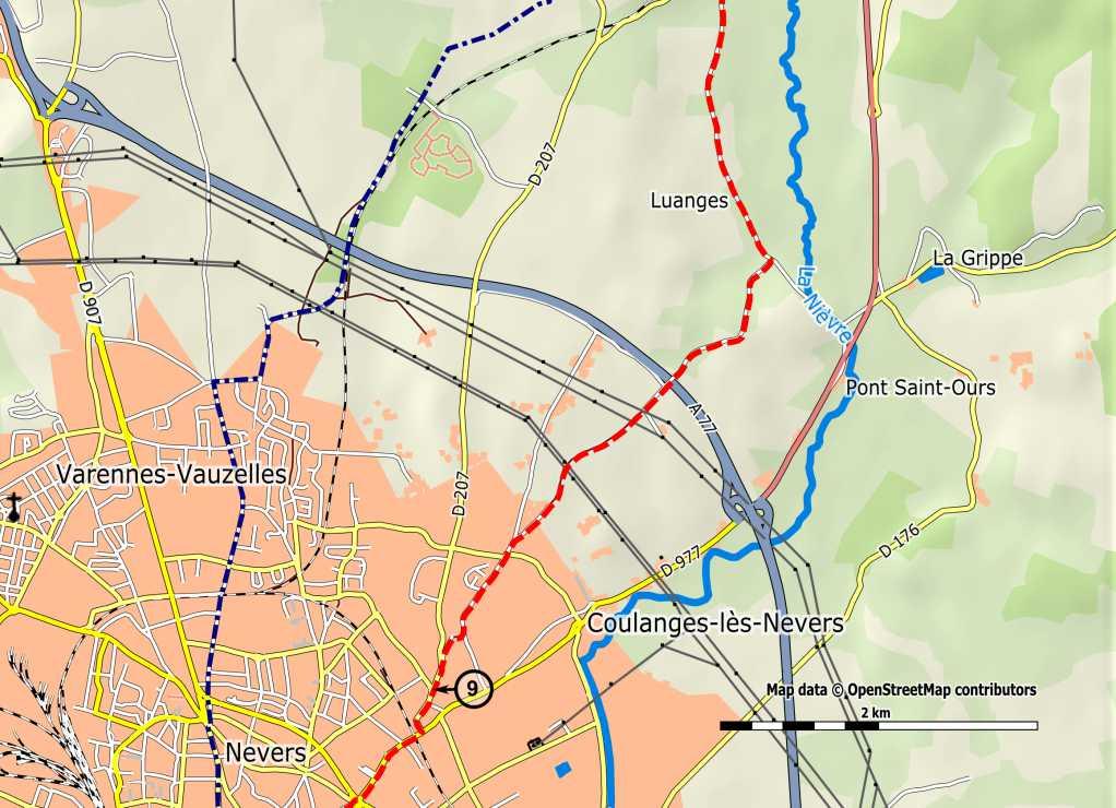
24 Section 1.1 Km 92.0 Sign exit Guérigny - entrance Urzy-Demeurs. [8] Km 93.1 Crossing (in a curve, after a bus stop): leave the D977 and take the Rue de l'usine (D207) to the right, direction Salle des Fêtes. Straight on, descending. Ignore the Place de la Liberté Albury (right). Km 93.5 Turn right and cross the bridge over the Nièvre, at the corner of a factory, then pass a small bridge. Sign exit Urzy. Km 94.1 Second bridge over the Nièvre. Km 94.3 Carrefour de Contre (Haras d'urzy): continue opposite, straight on (Route de la Coquillerie). Km 94.8 Carrefour de Chantemerle (Bocage the Niffon): straight ahead (Route de la Gare), along the railway. Km 95.5 Le Plessis (former station of Urzy) (to the left: view towards the Bordes castle, XI-XVIIth century). Km 96.3 Junction with the D148 (cemetery, water tap). [Urzy (B E)]. Continue straight via the D148, direction Varennes (to the left: view towards the castle of the Bishops of Nevers, XVIIth century). Km 96.8 Carrefour de Vivier: leave the D148 and take the VC-1 to the left, direction Pont-Saint-Ours. Km 96.9 Le Vivier: cross the hamlet. Km 97.8 Carrefour du Foulon (cross, at 50 m, on the right): straight ahead, ignore Feuilles (right). Km 98.4 Luanges: cross the hamlet. Km 98.9 After the first dirt road and before the sign Les Buttes Pont-Saint- Ours (B V): take the gravel road on the right. Km 99.3 Intersection of the Castle of Luanges: straight ahead, up towards the woods. Km 99.5 Ignore a path on the left, and continue straight ahead. Km Bridge over the A77 highway: straight ahead. Km Crossing on the right: straight ahead. Km Leave the road (which turns left towards Les Lombreaux) and continue straight on via the dirt road. Km Crossing: straight ahead. The path leads onto an asphalted/paved road (Chemin de la Tuilerie) (CR16), continue through a residential area. Km Crossing (grant priority): turn left (Rue des Bruyeres) (VC3). Km Crossing (mission cross): straight on, via the Rue des Filles. Km Crossing, straight ahead (view towards the cathedral). Km Leave the Rue des Filles; take the small road to the right, descending. Km Crossing: turn left into the Rue des Chaumottes (D207). Km Crossing (sign Nevers ): continue opposite, via the Rue de la Pique. [9] 24

25 25
26 Section 1.1 Km Continue via the Rue de la Pique. [9] Km Junction with the D977 ("Stop"): turn right (Rue Mlle Bourgeois), under the railway bridge. Km Intersection (traffic lights): straight ahead (this is still the Rue Mlle Bourgeois). (Former chapel of Saint-Silvain and, opposite, the former leper colony La Petite Vallière). Km Junction / roundabout La Croix Joyeuse: cross, and continue opposite via the Rue Jean Jaures, direction Centre-ville (city center). Km Chaméane Place (former gate of Barre: access for pilgrims to the old town): cross and continue opposite via the Rue de la Barre, descending, towards the church Saint-Etienne. Km [beginning of town map] Crossing: turn left into the Rue du Charnier. Saint-Etienne church: walk right around the church, cross the Place de la Charte and continue via the Rue de la Barre to the left, and then the Rue Saint-Etienne. Km Place Guy Coquille: cross the square, walk up to the right and then take the Rue Francois Mitterrand to the left. Old clock tower. Km Place Mancini: cross, then continue opposite via the Rue des Récollets, up, towards the Cathedral, Palace of the Dukes (former convent of Récollets, XIII-XVIIIth century). Km Place du Palais Ducal: cross, then right along the cathedral, via the Cloître Saint-Cyr. Km Nevers (C A H T B E W R services): North entrance of the cathedral. [10] Please send us your remarks etc. via 26


27 27
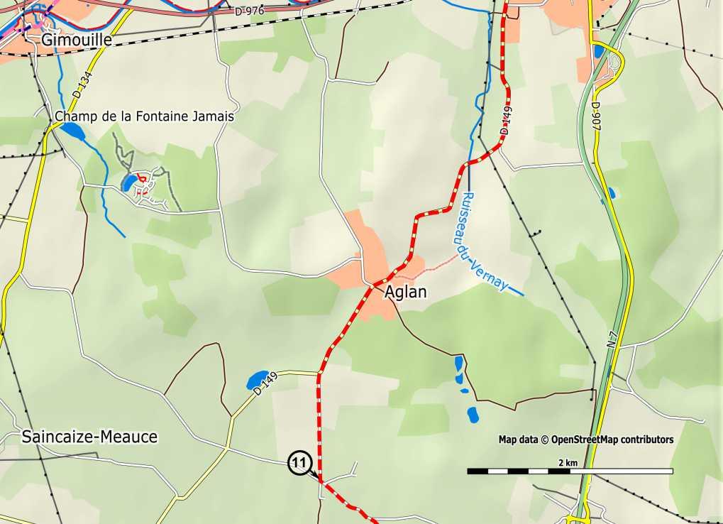
28 Section Nevers > Saint-Amand-Montrond: 91,5 km Km 0.0 Nevers: South entrance to the cathedral. Turn left into the Rue de l'abbe Boutilier, then right into the Rue de la Cathédrale, descending, crossing the Place du Palais (old episcopal palace from the XVIIIth century). At the end, turn right into the Rue de la Loire. [10] Km 0.3 Arrival at the Place Mossé, on the quay: turn left and cross the bridge over the Loire. >>> Here starts the variant via Augy-sur-Aubois to Ainay-le-Chateau, following the GR654. If you choose to do so: follow the red-white markings. See description on pages 160 t/m 167. Km 0.7 After the bridge: continue straight on, via the N7. Km 0.9 At traffic lights: straight ahead, direction Moulins, Saint-Pierre-le- Moûtier. Km 1.1 Signs: you leave Nevers and enter into Sermoise-sur-Loire (B V) and Challuy. Km 2.1 Intersection (traffic lights): leave the N7 and turn right into the D149 (Rue Louis Bonnet), direction Challuy. Km 2.3 Bifurcation and square: continue left and then straight on. Km 3.5 Junction / roundabout (cross): cross the D976 and continue via the D149 (Rue du Pavillon) direction Challuy-bourg. Km 4.1 Bridge over the canal along the Loire ( Canal Latéral á la Loire ). Km 4.5 Intersection with the D265 ("Stop"): continue straight on (Rue de l'eglise), direction Aglan, Saincaize. Km 4.6 Challuy (B W services) church. Km 4.7 Ignore the Rue de la Chapelle (left) and continue straight on. Km 5.1 Agricultural school (Lycée Agricole) (on the left): straight ahead. Km 5.8 Le Vieux Vernay (pigeon tower). Km 6.5 Intersection (Le Verney) (castle from the XV-XVIth century): continue along the D149, direction Aglan, Saincaize. Km 8.2 Yopson. Km 8.7 Aglan - crossing: continue straight on via the D149, direction Saincaize, Magny-Cours, descending. Km 9.7 Crossing: leave the D149 and turn left, towards Les Noues. Km 10.8 Crossing of Berge: after 50m, follow the main road. [11] 28

29 29
30 Section 1.2 Km 10.8 Crossing of Berge: after 50m, follow the main road. [11] Km 11.5 Follow the road, ignore a branch left (towards Les Pommaies). Km 12.5 Les Pitiaux: ignore the path straight on to Friot, turn right into the hamlet. Km 12.7 Crossroads: continue to the left (C4), direction Loucet. Km 13.4 Loucet - crossing: straight on via the Rue de Loucet. Km 13.7 Crossing at the D200 ("Stop"): continue straight (Rue du Pré Morand), towards the church. Km 14.2 Crossing Place de la Forge: continue via the small street Rue Saint- Vincent. Km 14.3 Magny-Cours (B W E services): church of Saint-Vincent. Continue via the Rue Saint-Vincent. Km 14.5 Cross and continue on the other side via the D200. Continue straight on, ignore the Rue de Champs-de-Magny (right). Km 15.0 Bridge over the bypass. Km 15.1 Turn right on C39 towards the depot Emaüs/Circuit automobile. Km 15.5 Continue straight on (don t take the dead end), along the Emaüs waste station ( déchetterie ). Km 15.7 Les Saules crossroads: ignore a small road to the right and to the left, and continue straight on. Km 16.5 After the Déchetterie, in the right turn, take the dirt road in front. Km 16.9 T junction. Take the grassy track to the right (wide view over the Loire valley on the left and over the valley of the Allier on the right. Partial view on the circuit of Magny-Cours). Km 17.5 Pass under the high-voltage line. Km 17.8 Ignore a small road to the right. View towards the water tower chateau d'eau des Américains ( ) and the water tower of St. Parize. Km 18.4 To the right, municipal depot. Continue straight ahead. Km 18.5 Ignore a street to the left and take the Rue des Craies straight on (sign Accueil pèlerin = pilgrims hostel). Km 19.1 Saint-Parize-le-Châtel (A). Entering the village (to the left a wooden cross). Continue to the right, slightly descending. A little further: ignore the Rue des Poirats (right) and continue straight ahead. Km 19.2 Turn left into the Rue de la Fontaine. Km 19.3 Crossing near wash-house. Opposite the wash-house turn right on the small grassy road, slightly up, to the church. Km 19.4 Church of Saint-Parize. (A visit to the crypt under the church is recommended). Leaving the church, continue to the left along the Rue de l'eglise. Km 19.6 Place du Champ de Foire. Turn right, direction Moiry/Magny- Cours, via the Rue de l'ouche. Km 19.8 Continue straight ahead. Ignore the Rue de l'abattoir (right). 30
31 Km 19.9 On T junction, turn left: C12 (Route de Rond de Bord). Km 20.2 You leave Saint-Parize (sign interdit aux 3.5t ). Km 22.1 After 2 km: [12a] 31
32 Section 1.2 Km 22.1 [12a] Km 22.3 Rond de Bord: continue straight on the C12. Km 23.6 Intersection: turn right and continue straight past the bifurcations for Naviot, Autry and Buy. Km 25.8 Leave the road. Crossing. Turn left into a small road (sign: 9t ). Km 26.6 Restored windmill (XIXth century): straight ahead. Moulin des Eventées. Km 27.4 Water mill; straight ahead. Km 28.0 Intersection (hamlet of Saint Roch) (grant priority): continue straight ahead. Km 28.5 Crossing with the D978a ("Stop"): turn right under the bridge over the D907 and then immediately turn left, onto the D431, Avenue du 8 mai, direction centre-ville (city center). Km 29.0 Intersection (cross): Place de la République: cross and then take - left- the Rue de Paris, direction Moulins, church, then turn right (Rue Nationale). Km 29.3 Saint-Pierre-le-Moûtier (A T W E R services) church. Before the church: take the Rue François Dumontel (one-way) and continue straight via the Rue du Puizat and the Rue du Crot Patin. Km 29.6 Bifurcation: continue straight on via the road on the right side of the wash-house, which becomes a dirt track further on. Km 30.0 Before the railway: take the small tunnel under the railway (Pont des ânes). At the end of the tunnel: turn left into a small road. Km 30.3 Bifurcation: ignore a small road (right). Km 30.4 Intersection: turn right, before the start of a row of poplars/aspens. After 50m, a curve to the left. Km 30.7 Bifurcation: turn right, up. Km 31.4 At the D268: continue on this D268 (and ignore a small road (left)). [12b] Past Bel air, then Le poirier jaune. Km 32.7 Crossroads: leave the D268 and turn right onto the C9, direction Livry. Km 33.8 At the D978a: turn left. Km 34.0 Livry (post, bakery) church. Continue on the D978a. Km 34.4 When leaving Livry: turn left onto the C7, direction Taloux, straight on, up. Km 35.5 Intersection Bise-vents: take the gravel road, sharp bend to the right, through the fields (overlooking the valley of the Allier). Km 36.2 At the D978a (dangerous point): cross and continue on the road on the other side, direction Chambon. Km 36.5 Bifurcation at Chambon: angled turn left. After 200m: the paved road becomes a grassy path, between hedges: straight on. [13a] 32


33 33
34 Section 1.2 Km 36.5 Grassy path, between hedges: straight on. [13a] Km 37.0 Crossroads: turn right, descending (after 50m, at next intersection, straight ahead). Km 37.3 At the D134: take the road left, along the Allier. Km 38.2 Intersection with the D978a: turn right and cross the bridge over the Allier. >>> (Border between the departments of Nièvre and Allier). Km 38.7 Crossroads: continue in a left turn on the D13, marked Toutes directions. Km 39.0 Crossing: straight ahead via the Rue Bichon, direction centre ville (city center), leaving the D13. Km 39.1 Le Veurdre (H A T B V W services): church square (Place Henri Barbusse), continue straight on via the Rue de Bourbon (one way) and then the D13 (Rue de Bourbon), direction Bourbon-l'Archambault. Km 39.5 Cemetery ( cimetière ) (water tap). Crossroads: turn right (Rue du Champ Rousseau), direction Champ Rousseau, Moulin Barras. Km 39.7 Roundabout: straight on (Rue du Champ Rousseau). Km 39.8 Intersection (double junction): continue straight on, via the Rue de Champ Rousseau, direction Mésangy. Km 40.9 Intersection (Le Coudrais: manor from the XVIth century): straight ahead. Km 41.5 Before the end of the descending road: turn left, onto a grassy path, steeply up, direction Mésangy, Moulin d'affouard. Km 41.6 Curve left, path between hedges. Km 42.1 Curve right, continue straight on. (After 300m, in the woods to the left, is the hole of the devil ( trou du diable )). Km 43.4 Mésangy crossing (cross). Take the path to the right, down (immediately after the sign Stop à 80m ). Fountain of Mésagny. Km 43.7 Follow the left branch of the road (at the sign privé (private)). Km 43.8 Small walking bridge over the Bieudre: take the path left, up (Moulin d'affouard). Km 44.2 Ignore a path from the right, straight on. [13b] Km 44.7 Ignore branch right, continue left on a small gravel road. Km 45.0 Grand Beaumont crossing with the D294 (Stop) (cross) (chapel on the right): turn left and follow the road, while crossing le Petit Beaumont Km 45.7 Intersection (before a bridge): leave the D294 and take a small road to the right. Km 46.5 Intersection (La Vieille Forge): continue straight ahead. Km 46.8 Crossing with the D1 ("Stop"): follow the D1 to the right, continue straight on (note: heavy traffic). 34


35 Km 48.6 Crossroads: leave the D1 and, across the street (to the right of a house), take a grassy path between hedges, continue straight on. Km 48.9 Cross a small road, continue straight. Km 49.4 The path becomes a paved road, intersection of Avignons (cross): turn right. [14a] 35
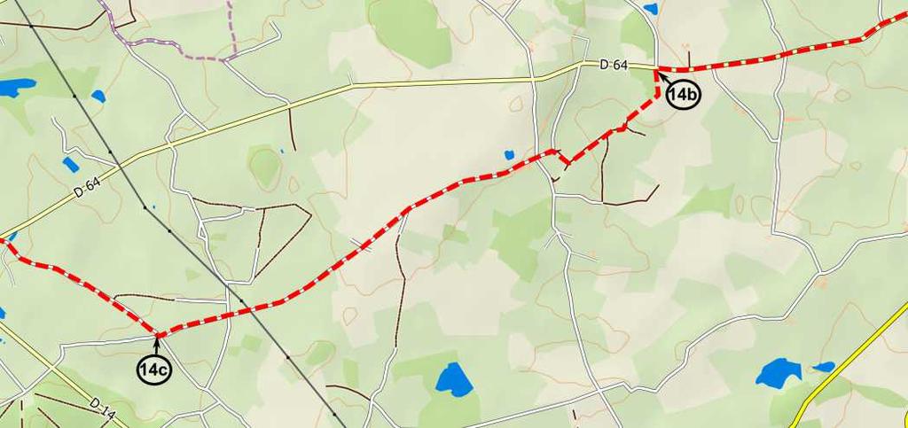
36 Section 1.2 Km 49.4 Intersection of Avignons (cross) [14a] Km 49.5 Before the water: follow the grassy path left between the hedges, continue straight. Km 50.4 Arrival at main road: turn immediately left (Rue de Ferrière), then straight ahead. Km 51.0 Crossing with the D1 ("Stop"): turn right (Rue du Dr Vinatier). Km 51.1 Lurcy-Lévis (H B V T G W services, pizzeria, fast food restaurant): church (Place de la Liberté). Cross this square, then the Place de la République, and then take the Rue du Capitaine Lafond (oneway), continue straight ahead. Km 51.4 Crossroads: turn left onto the D64 (Route de Valigny), direction Valigny, Ainay-le-Château, past the bridge over the Anduise, continue straight. Km 52.3 Breux intersection: straight on. Ignore L'Etang neuf (right). Km 54.0 Intersection (cross): straight ahead. Km 54.9 Citerne Fromentaux. Just before the road from Bourbin, les Carrais: leave the D64 and take a grassy path left, between the hedges. [14b] Km 55.0 Crossroads: continue straight ahead. Km 55.4 Bifurcation: continue on the main road that curves to the right. Km 55.5 Ignore a road from right and then one from the left: continue straight ahead, rising slightly. Km 55.9 Turn right, grassy path. Km 56.0 The path arrives on a gravel road (house): turn left, up. After 50m, crossing, turn left. Km 56.2 Intersection La Creuzerie: straight on, towards La Creuzerie, la Croix Charnay. Km 57.2 Bifurcation at La Croix Charny: turn right (Chemin de la Platriere). Km 57.9 Intersection (Les Boulats): straight on. Km 59.1 Intersection (Les Bois Denis): straight on. Km 59.7 Intersection (Les Cacherats): turn right (Chemin du Puits aux Renard Avignons) - La Croix, past Le Puits Renard, past Dardennes on the left: continue straight on. Km 61.3 Junction with the D64: turn left. Km 61.4 Valigny (B V W): church, junction with the D14, cross and continue straight on via the D64 (Route d'ainay) direction Isle-et- Bardais, Ainay-le-Chateau. Km 62.1 At Domaine de Villebon: leave the D64 and take a small road to the right (Chemin du Plaid à Villebon). [Isle-et-Bardais (T)]. Km 63.1 Ignore bifurcation to the right (Chemin de Chauvet à Carat). Km 63.4 Crossing: straight on (Chemin du Plaid à Villebon). [15a] 36

37 37
38 Section 1.2 Km 63.4 Crossing (Chemin du Plaid à Villebon). [15a] Km 63.5 In the curve: leave the road and take a grass path straight on, continue straight ahead. Ignore first a path from the left, then a path from the right. Km 64.4 Crossroads (water on the left): straight ahead. Km 64.5 Bifurcation: continue left, via a small road. Km 64.6 Crossing (Le Rocquet): cross and continue straight. Km 65.1 Intersection ("Stop"): turn left. Km 65.2 Crossing with the D64: turn right and follow the D64, along a deserted bridge across a canal. Km 66.0 Bardais: church - continue on the D64. Km 66.5 Junction with the D411: continue via the D64. Km 68.5 Junction with the D175 (Le Chandon): straight ahead. Km 69.2 Take the small asphalt road to the left [15b] (solid oak), sign «Vezien» on the left, direction Pontcharraud. Km 70.2 End of the road: turn right. Km 70.4 The Pontcharraud farm: turn left. Km 71.0 Bifurcation: keep left. Km 71.8 Junction: take the road to the right [the first houses of Ainay-le- Chateau]. Km 72.0 Arrival at the D64: turn left. Ainay-le-Château (HVW services). Km 72.2 (H - pilgrim hostel of the Voie de Vézelay, Rue des Récollets 20). Km 72.3 Junction with the D953 Place Victor Hugo. (Connection with the variant via Augy.) Cross the Place Victor Hugo, then pass a fortified gate and straight on, through the Rue de l'horloge. Then turn left, into the Rue des Maures to the church *). Back through the Rue des Maures, then turn left, into the Rue du Pont, descending. *) Tip for a nice cut and saving several hundreds of meters: walk, opposite the church entrance, into Rue de la Cure, descend stairs. At the end: go left, right and again left passing the footbridge. Turn left on D28 and continue at Km Km 73.1 Bridge over the Sologne - crossroads: turn left on the D28/Route de Meaulne, direction Braize, Meaulne. Km 73.3 Chapel of Saint Roch on the right. Km 74.6 Junction with the D550: leave the D28 and turn right, direction Le Crochet, Les Brosses and continue straight on. >>> (Border between the Allier and Cher departments). Km 74.9 Crossroads: continue straight ahead on. Km 75.4 Les Brosses: straight ahead. Km 75.7 Digue de l'etang: stay on the road. Km 76.0 At the Le Crochet farm (sign dead end): before the buildings turn immediately left into a dirt road and continue straight on. 38

39 Km 77.4 After a bend to the right, descend via the Route de la Besace: turn left and continue straight to Charenton. Km 79.3 At the junction with the D1: turn right and cross the bridge over the Marmande, continue via the Route de Coust, and then the Rue du Couvent. Km 79.5 On the right is the Rue de la Chapelle; after 10m, chapel of Notre-Dame de Grâce, portal of the ancient abbey of Bellevaux (statuette of the miracle of the Virgin Mary). [16a] 39
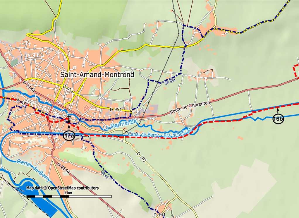
40 Section 1.2 Km 79.5 Pass the Rue de la Chapelle (on the right), continue the Route du Couvent. [16a] Km 79.6 Cross the D951. Arrival at the church square of Charenton-du-Cher (A W services). From the church: turn right, via the small street Rue de la Cure (one-way). Then turn right, onto the Rue Nationale (D951). Km 80.0 Crossroads / Place Buret. (It is possible to follow the D951 to the canal of Berry: follow the bank of the canal to Saint-Amand, at least until the maintenance work is completed). Cross and turn right onto the D37 (Rue d'arfeuilles, direction Arfeuilles, Meillant). Km 80.3 Bridge over the canal of Berry: leave the D37 and turn left into the Rue de l'usine (one-way) and continue straight. Km 81.1 Crossing ("Stop"): turn right towards the church. Km 81.3 Saint-Pierre-les-Étieux (G): before the church, turn left, direction Les Vivons, town hall ( mairie ). Km 81.7 Crossing (square): straight ahead. Km 81.8 Crossing near cemetery (water tap) (cross): continue straight ahead. Km 83.7 Crossing of Les Vivons: leave the road and take a dirt road, straight on. (At the corner a transformator). Km 84.4 Crossing with larger road: continue straight ahead. Km 84.9 Junction with the D951 (La Ravière) (Note: heavy traffic). Cross to the other side and take a small road, direction Les Places. Km 85.5 Berry Canal: cross the bridge and follow the road right along the canal. After 800m [16b] Km 87.0 Gâteau: crossing with larger road: turn left and then immediately right. Km 87.4 Moulin de Gâteau: cross and continue straight on, via a dirt road. Km 88.1 Crossing with larger road: straight ahead. Km 88.7 Bridge over the Marmande: continue straight ahead. Km 89.0 In the curve: leave the road and follow the lane along the canal. Km 90.3 Locks: continue straight on, along the left side of the canal. Km 91.3 Arrival at the Route des Fromenteaux. (From the crossing of the canal to the bridge of Orval over the Cher, the pilgrim's road is marked by the municipality, using scallop shells on standing stones on the sidewalk). Cross the canal and turn left, into the Rue des Fromentaux (bends at bifurcation after 200m to the left). At T-junction ("Stop"): turn left, into the Rue Grenouilliere. Then turn right into the small street Rue Charlotte, towards the church. Km 91.5 Saint-Amand-Montrond (T J B V W services, R in Orval): church of Saint-Amand. [17a] (H - pilgrim hostel of the Voie de Vézelay in Bouzais, at 5km). 40

41 41
42 Section Saint-Amand-Montrond > Gargilesse: 101,6 km Km 0.0 Saint-Amand-Montrond: church of Saint-Amand [17a]. Turn left into the Rue Porte Verte, then left into the Rue Saint-Jean, and then right into the Rue de l'hôtel-dieu. Cross the intersection. Turn left: Le Cours Manuel. Along the museum Saint-Vicq. Cross the Rue Jean Valette, then turn right into the Rue Benjamin Constant. Km 0.5 Crossing: cross and then continue left via the Rue du Dr Coulon, direction Centre hospitalier, SNCF. Km 1.0 Little square: turn right into the Rue des Goddess Odonnais, direction Centre hospitalier, SNCF. Km 1.2 Intersection (traffic lights): turn left onto the Avenue Jean Jaurès. Km 1.5 Crossing (right, after 50m, Rue Billeron, church of Saint Roch, XVIIth century, statue): straight ahead. Km 2.0 You leave Saint-Amand, across the bridge of Orval over the Cher Km 2.1 Orval (B R) Orval roundabout (church at 500m, right). Continue along the D951, direction Le Châtelet, Culan, up. Km 2.9 The road still goes up: turn right into the Impasse du Lavoir and, after 20m, turn left into the Chemin de la Croix du Sault. Km 3.3 Crossing ("Stop"): take the small road opposite, that becomes a gravel road afterwards. Km 4.3 Junction: continue opposite, via the road. Km 5.0 Crossing: straight on, towards the church. Km 5.1 Bouzais (H - pilgrim hostel of the Voie de Vézelay ). Straight ahead. Km 5.3 Crossing: turn right and cross the bridge over the Loubière. At the end of the bridge, before the cemetery (water tap): turn right (Rue de la Grenouillère), then turn left and follow the road which then turns left. Km 6.1 Crossing: turn right and take the C4 towards the highway. Km 6.7 Bridge over the highway A71: straight on, through Les Vernes. Km 8.0 Crossing of Rateau: straight on. Km 9.5 Crossing of Orcenais [17b], la Reuille: straight on. Km 10.0 Bifurcation of Arcomps: turn right, direction Fonstreux, Charron, Le Beau Champ. Km 10.7 Charron (The round meadow: an old fief of the Abbey Noirlac) (nice barn). Leave the road and take the small road on the left (beautiful lane), that becomes a grassy path, through woods. Km 11.9 Large fork (before a field): turn left. Km 12.2 Arrival on a road: turn right. Km 13.0 Crossing of Grand Orme: straight ahead, direction Marçais. Km 13.1 Crossing: turn left, direction Le Petit Bonnefond, then left again after 50m, into a gravel road, then straight ahead. Km 14.8 Crossing on the right: straight on. 42


43 Km 15.0 Crossing of La Planche: take the asphalted road to the left, rightangle bend. [18a] 43
44 Section 1.3 Km 15.0 Crossing of La Planche. [18a] Km 15.4 Crossing of The Petites Maisons: turn left, descending. Km 16.7 Loye-sur-Arnon (ATED): church. Crossing with the D951: cross and continue through a small street, at the corner of the barrestaurant. Km 16.8 Crossing: straight on, pass a small bridge. After 50m, crossing (cross): turn right, direction Etang Drulon. Km 17.4 Crossing (Mézereau): straight on. Km 17.6 Crossing (La Croix des Bourses): take the gravel road to the right, direction Moulin (= mill) the Mézéreau. Km 18.4 Mill: straight on, cross the small bridge (or the ford) over a branch of the Arnon, continue opposite along a grassy small road. Km 18.6 Cross the small bridge (or the ford) over the Arnon, and continue through undergrowth. After 50m, arrival on a larger road: turn right [view towards the church of Ardenais (K B V A)]. The road then turns left and rises. Km 19.0 Crossing: turn left and continue straight on. Km 20.3 Arrival on the tarmac: straight on. Km 20.4 Crossing (Le Grand Rouge): cross and take the grassy path opposite. Km 21.1 Arrival on the asphalt (Les Anglois): straight on. Km 21.3 Junction: continue opposite, always straight on. Km 23.1 Junction: continue opposite. Km 23.8 Intersection (La Bourgeoisie) [18b]: Beginning of a possible variant (see box on page 46). Take the gravel road opposite, straight on, through the Bois du Salut. Km 25.2 Crossing (thick, single oak tree in the middle): turn right. Km 25.4 Branch left: straight on. Km 25.5 You leave the forest (view towards the church of Puyferrand, left). Km 25.8 Junction: continue opposite, through a hollow road (poorly visible in the vegetation), descending, into the forest. Km 25.9 Bridge over the Cheminon: continue through the hollow road (vegetation), up. (View towards the bell tower of Puyferrand). Km 26.7 Intersection: cross the road and take the grassy path opposite, towards the church. Km 26.8 Arrival on a road: turn left and after 50m turn right and then after 150m turn right again, always following the wall/fence. Km 27.1 Church of Puyferrand: turn left, opposite the church, into a road which immediately turns to the right, descending (Rue Sainte Laurette). Km 27.5 Crossing of the D3 ( Stop ): cross, direction college, gendarmerie. Km 27.6 Crossing: turn right and then immediately left, into the Rue du Champ de Foire. 44
: church, Place")

45 Km 27.9 Le Châtelet (B V W services): church, Place Abbé Marius Salomon. Continue via the Rue du Champ de Foire, then turn right, then left into the Rue de la Gendarmerie towards the D3. [19a] 45
46 Section 1.3 Km 28.2 Towards the D3. [19a] Km 28.3 Crossing with the D3 ( Stop ): turn right. Km 28.4 Leave the D3 and take the C202 to the right, direction Vieille Forêt, La Montée Rouge, pass two bridges. Km 28.8 Crossing (cross): straight ahead, up. Km 30.2 Crossing: turn right to Les Archers. Km 30.8 Crossing (cross): turn left, direction Saint-Jeanvrin, always straight on. [for (A B) in La Petite Preugne, turn right]. Km 31.4 Crossing of Les Archers: ignore the road on your left and go straight on. Km 32.4 Crossing: ignore Le Vernier (left) and straight on. Km 33.3 Crossing of Les Loges (cross) [19b]: straight ahead, direction Saint- Jeanvrin. Km 34.8 Crossing: straight ahead, over the bridge, to Saint-Jeanvrin. Km 34.9 Saint-Jeanvrin: church (arrival of the direct variant from Saint-Aman. See box below). Turn right, towards the town hall, and straight ahead. Km 37.1 Sept-Fonds: cross the bridge over the stream of Sept-Fonds and turn left at the intersection. Km 39.2 Crossing (Le Pied du Montet): turn left and continue straight on to the church. [20a] Potential direct variant from Saint-Amand-Montrond to Châteaumeillant, through Saint-Jeanvrin, thereby avoiding Le Châtelet (a not marked route). Km 23.8 Crossing (La Bourgeoisie): take the road to the left, then opposite, descending, and straight on. Km 25.6 Ignore Les Guignards. Km 25.8 Bridge. Km 26.2 Crossing ( Stop ): straight ahead. Km 26.9 Crossing of the D65: straight ahead, direction La Foule. Km 29.0 Crossing of the D3 (Attention): turn left and cross the bridge after 50m. Km 29.9 Crossing: leave the D3 and turn right, direction La Foret, La Maison du Bois. Km 30.7 Crossing: straight ahead, ignore two branches/side-paths. Km 30.8 Crossing: turn left, direction La Maison du Bois, Saint-Jeanvrin. Km 31.2 Ignore La Maison du Bois (left) and straight on. Km 31.8 Left, "Le Grand Etang». Km 32.9 Saint-Jeanvrin: church - crossing (Stop): continue opposite. For the remainder of the route to Chateaumeillant: continue at Km

47 47
48 Section 1.3 Km 39.2 Continue straight on to the church. [20a] Km 39.9 Sign Châteaumeillant (C5): continue via the Rue de l'eglise. Km 40.3 Crossing of the D943: turn right (Rue de la Libération). Km 40.5 Châteaumeillant (H T A B W E services): church. Continue via the D943 (Rue de la Libération), direction La Châtre. Km 41.0 Place Saint-Blaise: continue via the D943 (Rue Etienne Berger), straight on (Avenue Antoine Meillet, then Route de la Châtre). Km 41.8 Leave the D943 and take a road to the right (Chemin d'acre), descending, towards Acre. Km 42.8 Passage of the stream of La Grange. >>> (Border of the Cher and Indre departments). Km 43.2 Bifurcation of Acre: turn left, up. Km 43.4 Domaine d'acre: straight ahead. Km 43.8 Memorial for paratroopers: leave the road and take the grassy path opposite. (View towards the church of Néret). Km 44.4 Ignore a small road (left) and continue straight on. Km 44.8 Arrival on the tarmac in Ferrières: straight ahead. Along the cemetery (water tap). Km 45.1 Crossing (monument to the fallen soldiers): turn right, towards the church. Km 45.2 Néret (T): church - crossing D68/D71 (Stop): turn right, onto the D71. [(A) La Tremble 2 km. Picks up after phone call]. Km 45.3 Leave the D71, take the small road to the left and after 50m an unpaved road opposite. Km 45.6 Crossing (remains of a cross): continue opposite via a grassy small road, to the left of the cross. Km 46.0 Bifurcation left (direction Le Maury): straight ahead. Km 46.3 After a small bridge: ignore a branch left (towards La Pérelle) and straight ahead. Km 46.5 Second branch to the left (towards La Pérelle): straight ahead (little used road, overgrown with grass). Km 47.2 Arrival on the road: turn left. [20b] Km 47.3 Right: wash-house (image of Joan of Arc as shepherdess). Km 47.4 Crossing of the D68: turn right. Km 48.6 Crossing: straight ahead, direction Lavau, Serres, camping. Km 49.2 Crossing of Priche (L'Orme Guérin): straight on. Km 50.0 Crossing with the D73 in Fontenay (Stop): continue opposite, direction Thevet. Km 50.2 Les Ormeaux, leave the D68 and take the gravel road to the left. Km 51.0 Crossroads: straight ahead, up. Km 51.5 Arrival on a road: turn left. 48


49 Km 52.2 Junction: continue opposite via the dirt road (walking trail), continue straight on. Km 53.2 After a bifurcation to the right: cross a bridge, continue straight ahead. Km 53.5 Back on the asphalt: straight on. [21a] 49
50 Section 1.3 Km 53.5 Back on the asphalt: straight on. [21a] Km 54.7 Crossing (Champ Viallard): take the C3 to the left. Km 54.8 Sign Lacs (Rue Laisnel de la Salle): straight on. Km 55.0 Crossing: turn left, towards the church. Km 55.3 Lacs: church. Crossing with the D73: cross and take opposite the church the Rue Saint-Martin. Km 55.5 Crossing: turn left. After 50m, cross a new intersection and continue opposite, along a soccer field and an urbanization. Km 55.9 Crossing: turn right and continue straight ahead. Km 56.6 Rue des Eglantines (Les Péradores). Km 57.0 Crossing: continue on the road opposite (prohibited for vehicles), which turns into a gravel road (soon after asphalted/paved), through the industrial area. Km 57.3 Crossing: straight on. Km 57.5 Arrival at the D73 (La Croix Félix): turn left into the Rue de la Croix Félix, straight on, descending. Km 57.9 Crossing of the D943 (Stop): continue opposite via the Rue du Maquis. After 50m take the Chemin des Envergeons to the left. Km 58.2 Crossing: turn right into the Rue des Crosses (5t). Bridge over a small canal. Km 58.5 Crossing: turn right into the Rue du Pont aux Laies and cross the bridge over the Indre. Km 58.6 At the end of the bridge: turn left into the Rue du Moulin Borgnon, after 10m take the stairs on the right, up. Km 58.7 Arrival at the Rue de l'abbaye: turn left, then after a bend to the right, and again to the left, the Rue Saint-Roch. [Montgivray 2km (T)] Km 58.9 Place du Dr Vergne: after 20m turn right into the Rue des Boeufs. Km 59.0 La Châtre (B J H A T W services) church (Place Maget). [21b] Continue via the Rue Accolas towards the town hall. Pass the town hall along the left side and then turn right onto the Avenue George Sand, straight on. Km 59.5 Roundabout (Place Jean-Louis Boncoeur), then the Place du Champ de Foire to the right: continue straight ahead via the Avenue George Sand. Km 59.7 Crossing: turn right into the Rue Frédéric Chopin, direction Parc des sports. Km 59.9 Take the first street left (Rue Barbadault) and continue straight on. Km 60.1 End of the road (sign priority): turn left (Rue des Prés Burat) and leave La Châtre, while ignoring the sports park (left). Km 60.8 Crossing: continue straight ahead (direction Le Colombier). Km 61.0 Take the grassy path, diagonally to the right (solid oak). Km 61.8 Leads onto an asphalted road - Le Terrier Jayard - straight on. 50
. Km 64.")
51 Km 61.9 Crossing: straight on. Km 63.1 Water tower - junction - turn left and then immediately right, into a grassy path (along refuse containers). Km 64.1 Crossing: straight on (marking GR654 and Association Berry). Km 64.2 Farm on your right - straight on via the dirt road. Km 64.6 Crossing of gravel roads: turn left (marked GR) (attention: follow the GR 654 until you leave Sarzay, at the corner of the cemetery). Km 65.6 Arrival at Petit Chenil (A B): turn right and then immediately left into a small street, cross a bridge over the Couarde, then continue via the grass road. Km 65.8 Arrival at an asphalt road: turn right. Km 66.2 Arrival at the D51: turn left. [22a] 51
52 Section 1.3 Km 66.2 D51 [22a] Km 66.9 Village entrance Sarzay (B E). Intersection: straight on. (Montgarni, 2km south via D41 B T G). Km 67.2 Village center: ignore the streets on the right straight on. Km 67.3 At the corner of the cemetery, just before the junction D51 / D41 - cross diagonally right across the parking lot and take the grassy path toward a cross, via a walking trail ENS. From here on follow again the marking by the Association of Saint James. Km 67.4 Cross: continue straight on, via the grassy path. Km 69.0 Turn right and cross the small bridge (or the ford) over the Vauvre. After 50m: arrival at the D51a in Vignonnet (cross): turn left. Km 69.1 Crossing: turn right, then straight ahead. Km 69.8 Crossing / triangle: turn left (marked GR). Km 70.0 Crossing of Bellevue (cross): straight ahead. Km 70.7 Crossing of the D19 in Montabin (Stop): turn left (marking GR). Km 70.9 Crossing, leave the D19 and turn right, direction Denormandie Fleurs, GAEC de l'abbé. Km 71.9 Crossing: turn left (walking trail). Km 72.1 Varennes (B), continue and pass the bridge over the Gourdon. Km 72.2 Crossing (cross): turn right, direction Le Beau. After 50m, second intersection: straight on. Km 72.5 Before the Les Traits farm: turn left (hairpin) via a gravel road, steeply up. Km 73.1 Arrival on a road (marking GR): cross and continue opposite via a small road, descending. Km 73.8 Le Sachet farm (asphalt) [22b]: continue straight ahead, up. Km 73.9 Leave the road and take a small asphalt road to the right (marked GR). Km 74.4 Junction: continue opposite, via the grassy path (marked GR). Km 74.9 The grassy path turns into a gravel track. Km 75.0 Pass the ford or the small bridge over the Aubord. Km 75.2 Le Pritemoux: continue straight ahead via the road. Km 75.4 Crossing (Les Entes): turn right. Km 75.6 Crossing of the D51: turn left (Beginning of the marking on the ground, with bronze shells (logo of the Voie de Vézelay), placed by the municipality of Neuvy-Saint-Sépulchre, at the initiative of the Amis de Saint et Pèlerins-Jacques de la voie de Vézelay). Km 75.9 Crossing (cross): straight ahead. Km 77.0 Crossing (cross): straight ahead. Km 77.2 Crossing of the D38: turn left (Rue du Maréchal Joffre). 52
, direction Cluis, Aigurande. Km 77.")
. Km 78.4 Back on the D38: continue to the right, straight on. Km 78.8 Before the intersection: leave the D38 and take a small road to the right (dead end), direction Le Terrier (sign walking trail).")
53 Km 77.5 Crossing of the D927 Neuvy-Saint-Sépulchre (H T V B W services): church - basilica. Continue from the Place du cardinal Eudes via the D38 (Rue du Maréchal Foch), direction Cluis, Aigurande. Km 77.6 Before the intersection: take the street to the right, towards a "plan d'eau" (= pond), centre de loisirs (= recreational area), and walk along the "plan d'eau" of Bouzanne. (End of the marking with bronze shells). Km 78.4 Back on the D38: continue to the right, straight on. Km 78.8 Before the intersection: leave the D38 and take a small road to the right (dead end), direction Le Terrier (sign walking trail). Km 79.0 Pass a small bridge. At the next junction: turn left, following the road. [23a] 53
54 Section 1.3 Km 79.0 After bridge and left turn, following the road. [23a] Km 79.3 End of the asphalt: continue opposite via the grassy, unpaved track (tricky when it rains a lot). Km 80.2 Arrival at a road (cross): turn right, up. Km 80.4 Crossing: continue to the left, via the road. Km 80.9 After the sign "Le Grand Vineuil, intersection (cross): turn right onto a gravel road and continue straight on. Km 82.4 Crossing of Boulimbert (cross): turn left and then, after 50m, turn right (forbidden 3.5t) (marking GR). [(G) in Bonavois 2 km]. << for Mouhers (K E) follow the road) >> Km 83.0 Crossing (cross): straight on (leaving the GR, view towards Mouhers). Km 83.6 Crossing of the D38: turn right. Km 83.7 Leave the D38 and take road to the left (5t), direction La Grange. Km 84.2 Crossing (cross): straight ahead. Km 84.5 Second intersection (cross): turn right, descending towards Cluisdessous. Km 84.9 Back on the D38 (Stop): continue opposite, over the bridge, up, to Cluis-dessous. Km 85.3 Ruins of the fortress of Cluis-dessous. Km 85.4 Bifurcation: turn left to the chapel of Notre-Dame de la Trinité. Km 85.9 Sign «Cluis» Rue de la Croix de Mission. Km 86.2 Crossing of the D54: turn right (Rue du Château), direction Badecon, Orsennes. Km 86.3 Cluis (H B E W services) church. [23b] Continue via the Rue de l'eglise. Km 86.4 Intersection: cross the Place du Marché, direction Pommiers, Orsennes. Continue via the Rue de la Prison and the Rue du Champ de Foire (D38, direction Orsennes, Eguzon). Km 86.5 Turn right into the Rue Berton, then turn left (dead end) to the overpass, continue straight. Km 87.1 Leave the road and continue straight on via a gravel road to the overpass (marking GR). Km 87.3 Junction: turn left. Km 87.5 Cluis overpass: cross (beautiful view). Km 88.0 At the end of the overpass: descend the slope to the left via a path (blue marking), before the bridge. Km 88.1 Arrival on the road: turn right, up. After 50m, at the intersection: turn left and cross the hamlet of Neuville. Km 88.7 Crossing of the D38 (Stop): turn right, up, continue straight ahead. Km 90.9 Sign Hallé: straight on. 54
: turn left and take")

55 Km 91.2 Crossing (Place de la Chapelle): turn left and take the road opposite (Route des vieux Puits), direction Frûlon. Km 91.5 Junction: turn right onto the Route du Lavoir (D30E), before the villa "Mon rêve». [24a] 55
56 Section 1.3 Km 91.5 Villa "Mon rêve». [24a] Km 91.7 Crossing (pond/wash-house): continue opposite via the D30E, straight ahead. Km 93.7 Crossing of the D45 (Stop): straight ahead, direction Pommiers. Km 94.6 Arrival via the Rue des Chaumes and junction of the D48 ( Stop ). Pommiers (W K post office) church (at 100m, on the right). Take the D48 to the left. Km 94.8 Crossing (cross): take the D45 to the right, direction Cuzion, Gargilesse. Km 95.5 Crossing: leave the D45 and turn right, direction Longirard, La Motte, Château Gaillard. Km 96.0 Ignore a road (left) and continue straight on. Km 96.6 Curve. Leave the road and take a gravel road opposite, which you leave after 20m to continue straight ahead via a grassy path (difficult to pass when it has rained a lot). << see also variant below>> Km 97.6 Ignore a small road (left) and continue straight on, descending, to the road. Km 97.7 Arrival at the D48 (dangerous!): turn left. Km 98.2 In the second turn to the right: leave the D48 and turn left into an unpaved track, descending (sign walking trail). Continue straight on via this track, following the bottom of the valley, and then up again. Km 99.6 The track becomes a gravel road: straight on. Km 99.8 Crossing: turn left. Km 99.9 Arrival on a road: continue to the left, straight ahead. Km Les Minières. Km Ignore road (right). Km Crossing of the D40: straight ahead, towards the town hall. Km Gargilesse (H B E post office) church (left, at 50m above the castle). 1.4 Gargilesse > Crozant: 18,8 km From this point the southern way is similar with the northern way (via Bourges). Km 0.0 Gargilesse: church. Place du château: Walk down to the left, via the D39. After 50 m: take the small road to the right, descending along the town hall and the post office. Km 96.6 If you follow the road, you walk via Longirard, La Motte and Château Gaillard to reach a concrete ford over the Terron after 3.2 km (attention: impossible to cross when it has rained a lot). Then you walk up 300m to Les Minières at Km There you turn to the left). 56
![Km 0.2 Cross the bridge over the Gargilesse. After 50m: back on the D39. At the intersection near the cemetery: take the road to the left, up. [(B T G V) in La Chaumerette 1 km] Km 0.](/docs-images/92/110863197/images/57-0.jpg "9 Intersection (Stop): continue opposite. Km 1.3 Leave the road in a bend and continue opposite via the gravel path, through fields and meadows, between hedges. Km 1.6 The gravel path becomes a trail, between hedges and fences (sometimes overgrown).")
57 Km 0.2 Cross the bridge over the Gargilesse. After 50m: back on the D39. At the intersection near the cemetery: take the road to the left, up. [(B T G V) in La Chaumerette 1 km] Km 0.9 Intersection (Stop): continue opposite. Km 1.3 Leave the road in a bend and continue opposite via the gravel path, through fields and meadows, between hedges. Km 1.6 The gravel path becomes a trail, between hedges and fences (sometimes overgrown). Km 1.9 The trail becomes a wider track, between meadows and vineyards. [25] 57
58 Section 1.4 Km 1.9 The trail becomes a track. [25] Km 2.0 Crossing (Le Cerisier): take the road to the right (Rue Griotte). Km 2.1 Bifurcation: walk towards Les Chérons (Route du lac), straight ahead. Km 3.0 Les Chérons: turn left (ignore the dead-end Route du Lac (right)), you enter a hamlet. Km 3.8 Crossing: turn right, into the Rue du Carroir and follow the road until Cuzion. Km 3.9 Bifurcation left: continue to the right, via the road. Km 4.7 Bridge: follow the road to the right, up. Km 5.2 You enter Cuzion via the Chemin du Gorgeat; then turn left, into the Rue du Moulin de Châteaubrun. Km 5.3 Crossing of Cuzion (W): roadcross and church (right). Before the church: take the main street and ignore the church (left). Km 5.4 Intersection: straight ahead. Km 5.5 Bifurcation: turn right, into the Rue de la Peureyre. [picnic place] Km 5.6 Place de la Peureyre: turn left at the end, take the main road that descends to the left (prohibited for all vehicles), first gravel, then overgrown with grass (on the right: view towards the tower of Châteaubrun). Km 5.8 Bifurcation to the right: continue straight ahead. Km 6.3 Bifurcation: ignore a gravel road (left) and turn right; second branch (on the right: viewpoint of Roche Sainte): take the path to the left, descending, through the forest. [slippery when raining] Km 6.6 Arrival on the banks of the Creuse: turn left, cross the stream. Km 6.7 Moulin de Châteaubrun (T G B). Ignore the rising road (left) and continue opposite via the gravel road, and then a path through undergrowth, left of the bungalows. Km 7.0 Arrival at a gravel road from the DFCI: turn right. Km 7.3 Turn right, a grassy path along the Creuse, follow this to the end. Km 7.8 Arrival at the D45 at the Pont des Piles. Take the road to the right, cross the bridge, then turn left at the junction, the D45, up, towards Eguzon. Km 8.0 Ignore the D45E (left) and continue straight on via the D45 (BV). Km 8.8 Leave the D45; in the third turn: turn right into a small road, direction Les Vignauds (against the one-way system), up. Km 9.2 Back on the D45 in Eguzonnet: cross after 50m and turn left into the Route du Ruisseau. Km 9.7 Bifurcation: continue opposite via the Chemin de la Fontaine. Km 10.0 Back on the D45: turn left, to Éguzon. Km 10.9 Éguzon (T B J W R services): church. Before the church: cross the Place de la Republique and, at the end, turn right onto the D


59 Km 11.0 Crossing: straight on via the D913, direction Crozant (Rue Camille Toussaints). Km 11.4 Crossing at the Salle des fêtes: leave the D913 and turn left, direction Bousset, Messant, straight on. Km 12.0 Bifurcation (after a curve, pond on your left): turn right, up. [26] 59
60 Section 1.4 Km 12.0 After a curve: turn right, up. [26] Km 12.3 Bifurcation: take the paved road to the left (towards Pré Cale), descending (high-voltage line). Km 12.6 Pré Calé: straight ahead, via the road. Km 13.0 In the curve, with the hamlet Charchet in sight: take the unpaved road to the left, descending. Km 13.4 Ignore a branch (right) and continue, turning left and descending. Km 13.5 Bridge over the Clavière (or ford, on the right): turn right, continue via the small road from the ford, up, through the forest. Km 13.6 Junction: take the road to the left, up. Km 13.9 The hamlet of La Feyte: arrival at the D36D. Cross the D36D and continue opposite via the small road. Km 14.3 Bifurcation: follow the road to the right. >>> (Border of the Indre and Creuse departments). Km 14.5 Crossing: turn left, then after 10m: take a grassy path to the right, between two fences. Km 14.8 Junction: take the paved road to the left; after 50m: take the small road to the right. Km 15.2 Back on the road: turn right and then straight on towards Crozant. Ignore successively two roads (left) (at km 16 and 16.3). Km 16.4 Bifurcation to the right: straight ahead. Km 17.2 Crossing of Vitrat: continue opposite (forbidden for cars/buses). Km 17.3 New intersection: turn left, direction Crozant. Km 18.3 Bridge over the Sédelle: follow road up to Crozant. Km 18.6 Arrival in Crozant: walk up to the junction with the D72 (hotel) and continue via the small road opposite, up. Cross the road again and continue opposite, via the path up to the church. Km 18.8 Crozant (H T B V D W services): church. 60

61 To pass on your remarks etc., see 61
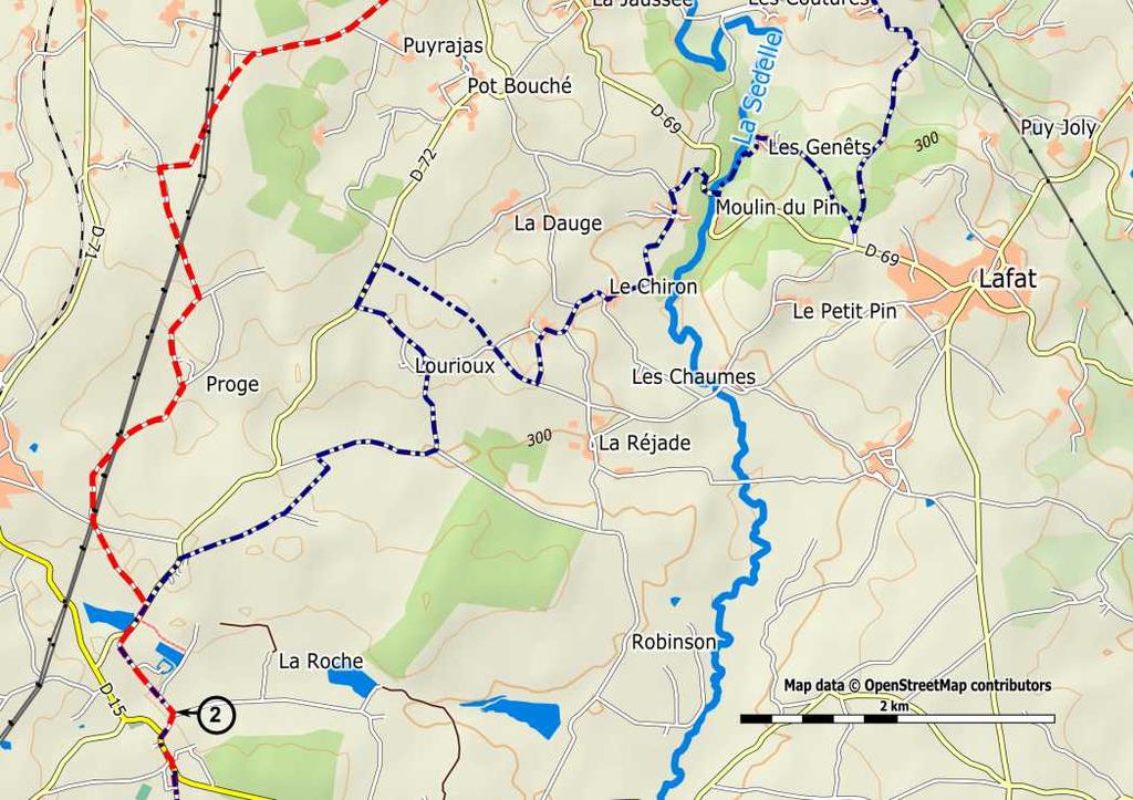
62 Section Crozant > La Coquille Crozant > La Souterraine: 24,5 km Km 0.0 Crozant. [1] Return to the GR to descend into the Sedelle valley. Keep following the road until the junction with the D913. Turn right to cross the bridge of Charraud, then turn left onto the D72. Pass the "Grange du Bois" (grange = barn), stay on the D72, then pass: Coublins, Josnon, la Goux and finally: Km 6.2 La Chapelle-Baloue (V B F). Stay on the D72, direction Saint- Germain-Beaupré and at the cemetery turn right (C6) direction Puyrajas. Ignore the branching of Puyrajas (dead end) and continue in the direction of Bazelat. At the next intersection: leave Mazerolles to the right and continue to the left. Continue straight on. At the T-junction: turn right and at the intersection of Chézeaupion go left, due south. After 400 meters: T-junction, turn right, cross the hamlet of Proge, the road turns to the left. At the next junction continue straight on (under the high voltage cables) to return on the D72. There you will find the GR again. Turn right, pass in front of a pond (with a beautiful picnic area) and turn left, into a small road (château/castle). At the end, near the cross, turn right and arrive at: Km 14.2 Saint-Germain-Beaupré (A B). [2] 62

63 63
64 Section 2 Km 14.2 Saint-Germain-Beaupré. [2] Follow the Grande Rue and at the end, at the location of the cross, turn diagonally to the right, towards Le Boucheron. At the end of the hamlet turn left, direction La Chenedière. After 400 meters: leave this road and take the grassy road (still the GR!). Continue straight on and pass several crossings. At the end of the path: turn right on a road. Continue straight on until you reach the D72. Turn left: Km 18.7 Saint-Agnant-de-Versillat (B). Stay on the D72 and leave the village. Walk a little up, right next to the cemetery ( lanterne des morts'), parallel to the D72. Immediately after the cemetery, turn right on the dirt road (beware: hard to see) and continue straight on. After a pond, a crossroads: continue straight on and leave the GR. Arrival at a road: turn right and after 50 meters turn left. Cross the hamlet of Les Chassagnes and continue straight on, pass a bridge and at the crossroads: ignore the road to Bousseresse on the left and continue straight on. T-junction with bypass: turn right, cross the bridge over the railway. In front of the Leclerc supermarket: turn left, into the Avenue Mermoz, then turn right into Rue Martin Nadaud. At the «stop»: turn left, into the Boulevard Mestadier and follow the bronze shells on the ground, to reach the church of: Km 24.5 La Souterraine (A B W R) La Souterraine > Benevent l'abbey 21,5 km Km 24.5 La Souterraine. From the church: cross the marketplace, pass under the Porte Saint Jean and turn right, into the rue Saint Jacques. Then turn left into the Rue de Bessereix. At the crossroads: continue straight on, until the bend. Do not follow the GR. Continue straight on, direction Fursac and at a split turn left into the Rue Auguste Coulon, then continue straight on. You reach the bridge over the railway. [3a] 64
65 65
66 Section 2 Km 26.2 Cross the bridge over the railway. [3a] Arrive at the dual motorway: turn right, to pass under the motorway. At the end of the tunnel: turn left and at the end turn right, onto the D10, direction Saint-Priest-la-Feuille (be careful, traffic). Continue along this road for about 2km and then arrive in Km 28.5 Sagnemoussouse. Cross the village, following the D10 until Km 31.0 Saint-Priest-la-Feuille (B). Past the church: diagonally to the right, still on the D10, direction Chamborand. At the crossroads: do not take the D74 (Fursac), but stay a while on the D10. After 300 meters: turn right, into the small Route du Bec. At the intersection of Bec: turn left and cross this hamlet. After 100 meters: turn right, into a small road (Laisse-Dire) that soon becomes a dirt road. At a junction: go diagonally to the left, up, and then again to the left, into a small road that joins the D10 again. Turn right and cross the bridge: Km 35.0 Pont sur la Gartempe [3b]. Past the river, at the crossroads, leave the D-road and turn right into the small road, up, to Puy Beaumas. Ignore a road to the left and at the junction go diagonally left (back on the GR), towards houses. Cross this hamlet, the asphalt gives way to stones. T-junction: turn left and arrive on the D10 again. Follow the D10 for 100 meters, cross, and continue along a road that descends. Crossroads: turn right, pass a pond and then a cemetery. Turn right onto the D49, cross the D4, and then turn left to the church of: Km 38.5 Chamborand. Follow the D10 again, direction Bénévent. Cross the hamlet of Bellivier. [4] 66

67 67
68 Section 2 Km 39.8 Cross the hamlet of Bellivier [4], and continue along the D10. Ignore the roads to the left. Cross the bridge and arrive at the crossing with the D48. Turn left, and then turn right after 750 meters, at the intersection of La Toueille (GR). Continue along the ponds to reach the hamlet of Le Bourale. In the hamlet: take the second road on the left. After 1.5 km the road is covered with asphalt. Arrive in the hamlet of Sauzet. Leave the GR to the left, and continue straight on to the D10. Take the D10 to the left, to: Km 46.0 Bénévent-l'Abbaye (H) Bénévent > Châtelus-le-Marcheix: 19,4 km Km 46.0 Bénévent-l'Abbaye. From the church: follow the D10 again, direction Fursac. Then turn left towards college, past the stadium. After the stadium: turn left and immediately turn right and contiue to the crossing of the D914. At the «stop»: turn right, direction Marsac, Cross Les Coultures and ignore the road to La Betoulle to the right. After 350 meters: leave the D- road and turn left into a dirt road, up, through a forest. At the crossroads: continue straight on. At the main road: turn left and then immediately turn right, direction Souliers, Lagémard. At the junction: continue direction Lagémard. After 100 meters: turn right, into a wide stone road which leads to the corner of a cemetery. Turn right, into the road leading to Km 50.6 Marsac (A B R). At the crossing of the D914: turn left and then continue straight on, railway crossing, straight on, wastewater treatment, straight on, direction Limoges. After 200 meters: turn left, direction Les Rorgues. At the first intersection: turn left, at the second continue straight on (up), at the third intersection turn left (still rising). At the sigh Chapel go straight on at the crossing. After the hamlet, descend to the right via a road that then goes up again to a forest, to return to the D 57. Turn right and follow this road to the church of Km 55.1 Arrènes. Take the D48 again, direction Saint-Goussaud. Crossing with the D50: stay on the D48. After 600 meters: [5]. 68


69 69
70 Section 2 Km 56.0 [5]. After 300 meters, at the crossing of La Ronze, take the small road to the left, which descends to the hamlet of Abbaye. In the bend: leave (after the brook) the road and take a path (GR). At a crossing: continue straight on, through the forest. At the main road: turn to the right, to the crossing of Champégaud. There we take the path that goes from the right corner of the house. Continue straight on, to come back to the D48. Turn left and arrive in Km 59.5 Saint-Goussaud (B) (Possibility to go directly to Les Billanges along the GR654-13km). Cross the village and continue along the D48, direction Chatelus-le- Marcheix. At the first crossing: leave the paved road to take a dirt road (GR4) at the junction of the road to Chatain. The road descends between undergrowth. At the junction: continue straight on and arrive on the D62: cross it and take the road opposite. Crossing: continue straight on. Crossing of Villechabrole: take the road opposite. Once back on the road you just crossed, follow it for 150 meters and then take the road (left) which goes into the forest (up). At crossings: remain on the road with the GR markings. Km 65.4 At the D8: turn right. (For Châtelus-le-Marcheix (H B W) turn left) Châtelus > Saint-Leonard-de-Noblat: 29,5 km Km 65.4 Châtelus-le-Marcheix. Leave Châtelus along the D8 direction Les Billanges. Crossing with the D48: stay on the D8. Cross Le Levadoux, continue straight on, (B in Beaumont) then cross Villemaumy: straight on. Crossing of the D8 and the D8a: take the D8a to the left, which later in the Vienne becomes the D29. After 1.3 km on this road, while leaving the forest, turn left on the narrow path between fields (meeting with GR from the other side, moderate signaling of the way). After 750m [6]. 70


71 71
72 Section 2 Km 71.4 [6]. After 150m you reach the D29a, continue straight on, through the hamlet of: Km 71.5 Vivareix. (BV in La Besse, 2.5 km off the route). While leaving this hamlet: take the dirt road to the right, which runs between the houses. Crossing: contiue straight on, via the GR. Pass several crossings but remain on the GR. After about 3km reach the D29. Turn left and further on leave the GR to the right. Arrive at the church of: Km 74.9 Les Billanges (H B). Follow the D29. Intersection with the D50: stay on the D29. Cross the bridge over the Gance, and reach the D5. Take that road to the left (careful: lots of traffic!), direction Saint- Léonard-de-Noblat. Pass the camp ground and arrive on Km 79.7 Le Pont du Dognon. Cross the river Le Taurion and turn left, into an ascending path with pebbles, pass between the houses, cross a road, and stay on the GR. Arrival at the D5: cross it and continue straight on via the GR. Hamlet of Orgnac: the road becomes asphalted, (for BV in La Gasnerie, turn right after 150m). Pass holiday settlement. 100m after Orgnac turn right (90 degrees) into a stone road, which descends and then rises through a forest and ends up at the cross of La Maléterie (restored). Continue opposite, via a grassy road (the GR turns right), to the D19 and continue to: Km 84.2 Le Châtenet-en-Dognon. Pass the church and follow the D19. Crossing: turn right onto the D58a and after 300 meters: turn left, to Lachenaud then Lourdes. After 1,5km: small bridge. [7] Km Shortened route Foyer Jean XXIII in Lussac (see the green dotted line on the map opposite page 74): 100 m after the side road left to Clémensanne-Sud, in the bend after the pylon, leave the road and the GR and take a path on the left that goes through the fields. You will pass the old mill Lajoumard. Go left on asphalt road (C8). Cross the bridge over the Galamache (on your left side the old mill of La Roche). Follow the road (rising) to the cross road to Lussac. Turn sharp right direction Lussac. At the fork: choose left and follow the signs, showing the way to Lussac (C). The next day: Go back to the fork. Go sharp left. Follow this small road up to the T-junction (<Stop>) with the D39. Turn left on the D39. This becomes later the rue Dr Jagot Lacoussière. Follow this road until the intersection of Saint-Léonard-de-Noblat. Continue from Km 94.9 of the route. 72


73 73
74 Section 2 Km 86.2 Small bridge. [7] After 500m arrive on a small road. Turn left (from here follow the GR654 to Saint-Leonard-de-Noblat) Straight ahead. Pass Clémensanne-Nord (on your right) and Clémensanne-Sud (on your left) [for Lussac (C), see page 72]. Km 87.2 The road turns first to the right, then left. At a junction, go sharp right towards Les Boutonnes. Km 87.6 Turn left at the crossing gravel roads. From here always straightthrough via dirt road along/between vegetation (this part was difficult to mark!). Go straight on arable land between fields, till an asphalt road (C17). Km 90.6 Turn right. Follow this road till T-junction with D39 (Marsac). Km 91.1 Turn left on D39. After 800m, go right towards Le Puy Faucher. After 100m: turn left on gravel road (descending). Arrive again on D39, turn right. Before the bridge (Le Pont au Puy) leave the D39 to the right. Cross the stream the Tard, and follow the path up to a plateau. Pass Maisonneuve, go at the end of the path to the right (Le Haut Dandalais). Cross the asphalt road and go straight ahead, through a dirt road, to Dandalais. There, go right twice. The GR looks over the valley of the Vienne and then opens onto a paved road. Turn left and continue this road - which further on is paved - through Puy Lassaud. Than arrive in Saint-Léonard, on the ring road. Here you leave the GR. Km 94.9 Cross and walk along Rue Jean Jaures, Place de la Republique and Rue Gay-Lussac to the collegiate church of Saint-Léonard-de-Noblat (H B W R) Saint-Léonard-de-Noblat > Limoges: 22,3km Km 94.9 Saint-Léonard-de-Noblat. From the collegiate church: consecutively take the Rue Lamazière, the Rue G.Perrin, the Chemin de Pavé. At the end turn right: Avenue du Général de Gaulle. Pass under the railway bridge and cross the Avenue de Limoges diagonally left. Go up the Rue du Vieux Pont, then cross the river Vienne, using the historic bridge (Pont Noblat). Turn right and then turn left onto the D941, and again turn left onto the D65. After the porcelain factory: take the road to the right (GR), up, to the hamlet of: Km 98.2 Chigot. Continue straight on (so leave the GR). In the hamlet: at the house with the sign Menuiserie (=carpentry) (on the left side), turn right into a small road that becomes a dirt road. This leads to the V2, turn right, the hamlet of La Chapelle, keep following the road and arrive in the hamlet of: Km Lafont. Stay on the V2 (changes in C2), direction Aureil, pass Les Charrauds. [8a] 74
75 75
76 Section 2 Km Les Charrauds [8a]. Ignore various branches and continue to the D44a1. Turn left onto this road. Crossing with the D44: cross and arrive at the church of: Km Aureil (H A). Before the cemetery: take the path to the left, to Bost. In the hamlet: keep following the road. Take the 'Impasse du Monastère. This changes into a grassy track and arrive on the D979. Turn right and at the crossing with the D44 turn left, direction Laubaudie. At the end of this hamlet turn right: into a gravel road. Follow it for 800 meters and then turn left, direction Crouseix. When you reach the road, turn right to arrive in: Km Crouseix [8b]. Turn left and follow the road through the village which makes a right turn. Turn right onto the D98. Cross the bridge, pass a pond. Stay on the D-road and after 600 meters: bend to the left, into a path to the church of: Km Feytiat. Turn right, into the Avenue Winston Churchill, then left the Avenue Georges Clemenceau. At the roundabout: continue straight on via the Avenue Frederic Legrand. At the roundabout: turn left, onto the D979. Crossing of Crézin: continue straight on. At the crossing with the D55a also: continue straight on. After the roundabout of the industrial area: bend to the right, into the Rue Malinvaud [8c]. At the end of this street: follow the grassy road, then take the Rue Bas Fargeas, up. At the end of this street: turn left, into the Avenue de Lattre de Tassigny. Cross the highway, follow the bronze shells on the ground, and take the Avenue du Sablard. At the second crossing: cross, descend the stairs and continue along the footpath. Cross the Vienne via the bridge St-Etienne and go up, into the Rue du Pont. [9a] 76

77 77
78 Section 2 Km Rue du Pont [9a], then left, into the Rue Saint-Domnolet and at the end turn right, into Rue de la Regle to arrive at the Place de la Cathédrale Saint-Etienne in: Km Limoges (C A W R) Limoges > Flavignac: 28,4 km Km Limoges. From the Place Saint-Etienne follow the Rue des Allois, the Rue de la Haute Cité, the Rue de la Cité, the Place de la Cité, the Rue Raspail, the Place Wilson, the Rue du Collège, the Place Saint- Pierre, the Rue Dalesme, and the Rue Saint-Martial. Then, the Place de la République, again the Rue Saint-Martial, cross the Rue Jean Jaurès and take the Rue du Clocher. At the Place Saint-Michel, turn left into the Rue Ferrerie, cross the Place des Bancs, then turn right onto the Place du Poids Public and turn right again, into the Rue de la Boucherie. Place de la Motte and across into the Rue Othon Péconnet. Cross the Place d'aine [9b] and turn left into the Rue des Arènes. Place des Carmes, turn left into the Avenue Jean Foucaud and immediately turn right into the Rue Neuve des Carmes and again turn left into the Rue Saint-Eloi. At the end turn left onto the Cours Jean Pénicaud, then sharply right into the Rue Pétiniaud-Beaupeyrat. At the crossing: diagonally left into the Rue Pierre et Marie Curie, which you follow to the end, in the meantime crossing several intersections. Then continue via the Rue Bourneville. Km Roundabout of La Cornue, continue straight on through the Avenue des Bayles and at a crossing continue straight on via the Avenue du Château, which becomes the Avenue de Vignes Basses. (A in Isle, SW of Limoges) [10a] 78

79 79
80 Section 2 Avenue de Basses Vignes. [10a] Km Roundabout of La Croix Bachaud: Take the D74 to Merignac. At the next roundabout: leave the D74 and take the road opposite (C9). At the crossing: continue straight on and enter: Km Mérignac. Turn left into the Avenue de Mérignac then, at the end of the village, go left and take the Rue du Vignoble to continue via a dirt road that becomes an asphalt road: Chemin de Puy Panard, which leads to the N21. Turn right, cross the railway bridge, pass the train station and turn left, into the Rue de l'abreuvoir. Cross the bridge over the river Vienne, take the stairs and turn left into the Rue Rochefroide, then the Rue Sadi-Carnot, to the church of: Km Aixe-sur-Vienne (W R). [10b] Take the Rue Saboterie and the Rue Victor Hugo, then the D20, direction Les Cars, Flavignac. Follow the Rue Pichenaud, pass in front of the supermarket and take after 300m the C203 to the left. Descend the Rue du Mas Neuf and pass the mills of: Moreau, David, Le Mas Neuf and Japaud, while following the Aixette. Arrive on the D110, turn left, pass the bridge and continue to the crossing of Le Breuil. Turn right to Mardaloux, cross this hamlet, always straight on. La Judie, keep following this road until the D17. There turn right and arrive in: Km Saint-Martin-le-Vieux. Near the church: turn left, to Bord, and cross this hamlet. [11a] 80

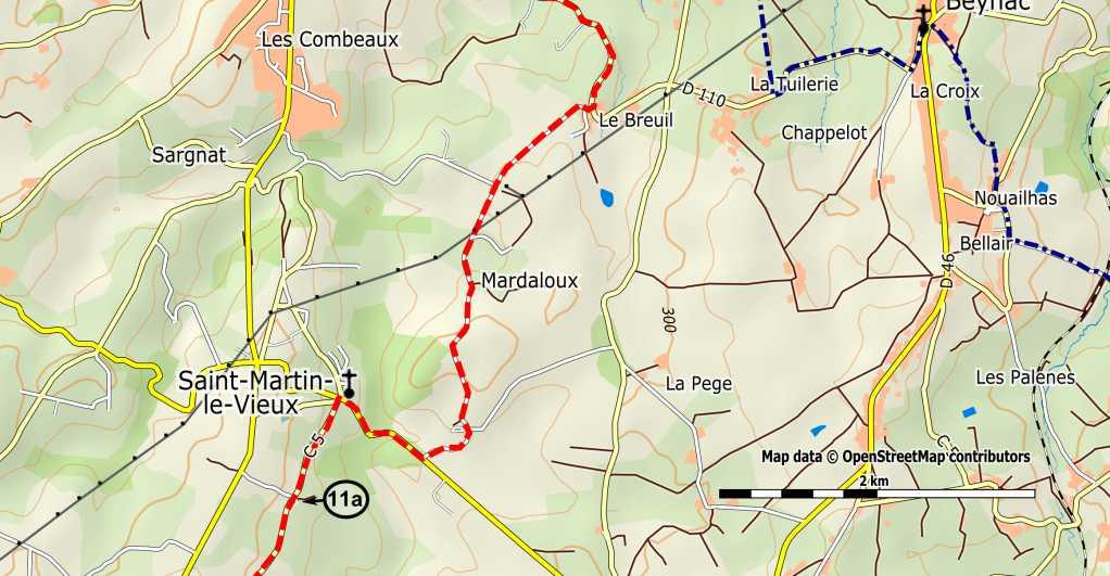

81 81
82 Section 2 Km Cross Bord [11a] and keep following the road, to the hamlet of Domarias. There turn left, to Lavignac. At the crossing with the D46: turn right and stay on this D-road. At the end: turn right and arrive at the church of: Km Flavignac (H T W) Flavignac > La Coquille: 29,5 km Km Flavignac. Opposite the church: take the Rue Pasteur (D46). Crossing with the D20: turn left. Crossing with the C224 to Beyrand: continue straight on to the church of: Km Les Cars (BV). Take the D15, then turn right on the D21. After 400 meters: turn left, to Le Valois [11b]. Cross this hamlet and pass La Maison Blanche (the white house), la Teyssière, les Fosses. At the crossing: continue straight on and arrive in Lautrette. Cross this hamlet, Route de Pageas, pass a pond, and at the end of a bend: turn left, into a dirt road, up, through a forest, to La Petite Veyssière. At a junction: first turn right, then turn left. At two crossings: continue straight on and arrive at the D141n. Turn right and then immediately turn left, into a new road, descending. Cross a small bridge and go up to a place called Maître Antony. Follow the asphalt, cross a road, and continue straight on via a path that leads to the D15, parallel to the N21 (at the fence go left). [12] 82


83 83
84 Section 2 Km Path to the D15. [12] Along a small industrial estate. The road becomes a grassy path. There turn right, cross at the traffic lights and continue via the Rue Chabrol, then the Rue Mardochée, and the Rue Côte de la Minoterie. Cross the D901 and continue straight on. Cross the Tardoise and take the Boulevard du Fort rise, up, to arrive at the church of: Km Châlus (W). There, take the Rue du Clocher, the Rue Salardine, the Rue de l'europe. Cross the Place Cardailhac and turn right, direction Dounazac, into the Avenue du 11 novembre. At the end: turn left, pass under the (former) railway bridge. After 500 meters: turn left, to Mettes, and continue via the sunken road that is most to the left. Upon reaching the asphalt road: continue straight on to: Km Le Lac. Turn left and then turn right onto the D64a1, to arrive at the «stop» sign of the D64. Turn right, onto the D64 and after 200 meters take a dirt road which leads into a forest. Cross a small bridge and continue along the road that passes the pond of Maison Neuve, to: Km Monchaty. At the crossing: continue straight on, via the Chemin de la Forge. Before the bridge: turn right and walk along a pond. Beyond the castle: left. At homes: left and immediatiely right on the N2. Km Firbeix (W). After the church turn left towards Puybernard. The road soon turns into a forest road, which leads to the Route d'aillac. Take the left road. Descend, cross the railway, and take a path to the right, that runs along the tracks. After 700 meters [13]. 84


85 85
86 Section 2 Km Path along the tracks [13]. Km At La Lande du Puy leave the tracks and continue along asphalt. Km At the crossing: turn left and after 100 meters, at the next crossing, turn right. Leave Saint-Pierre-de-Frugie (H) on the left. Km At the end of the hamlet of Vervenille: turn left, onto a road. After 300 meters, at a crossing: turn right, to La Roche. Km T-junction, La Roche: turn right, onto a road, up. After 200 meters: turn left, onto a path that first descends along a forest and then rises to Sainte Marie de Frugie. Km At the wooden signpost after the pond, follow direction La Coquille 2km. Go right past a house on a small asphalt road. Take in the bend to the left a dirt road straight ahead. Arriving at the houses, turn left. Arriving on the N21, turn left and, along the roadside, walk to: Km La Coquille (H A W R). To pass on your remarks etc., see 86

87 87
88 Section La Coquille > Sainte-Foy-La-Grande La Coquille > Thiviers: 18,5 km Km 0.0 La Coquille. [1] From the church: take the rue La Boétie, descending. Turn left at the end, into the D67, direction Saint-Paul-la-Roche. Then go left again: the Route du Moulin de Margaud. At the crossing: turn right, Moulin de Margaud. Continue, up, to Les Rivailles. Km 1.5 Les Rivailles. Keep following the road, which turns to the right, up, into the forest. At the crossing: take the path to the right, cross the plateau, straight on, through woods and fields. Crossing: continue straight on, along a grassy path. Keep going straight on, through undergrowth. Km 3.5 Arriving on the D67: turn left. Then, at the intersection with the Route de la Bussiere: continue in the middle, along a dirt path, through the fields. Arriving on a road. Continue opposite, via the Chemin des Cupules. Again arriving on a road. Continue straight on. Km 6.1 Crossing: continue straight on, via a small road, to Km 7.6 Pont Fermier. Follow the road for about 3 km. Then, at the sign Coderc, turn left at a crossroads. [2] 88

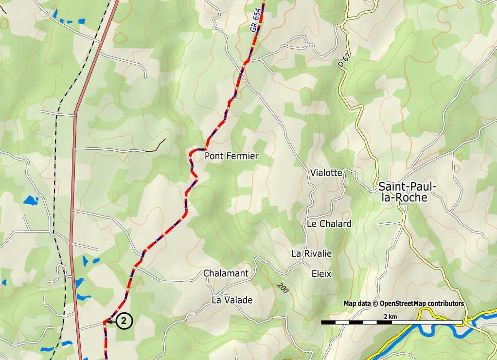
89 89
90 Section 3 Km 10.6 At a junction [2], continue to the left. Km 11.8 At the next crossing (du Petit Clos): Turn right and cross the road (D78): continue straight on, via a path, which leads to a paved road. Turn right there: Km 13.2 water tower, crossing. Turn left, into a road which leads in a straight line towards Thiviers. Before the N 21: take a small one-way road to the left and at the next crossing turn left again. Continue to the D81, near the hamlet of: Km 15.6 Bouilloux: turn right at the "stop". Another crossing. Continue straight on, via the Avenue Eugène Leroy. Km 18.0 Roundabout of Saint Roch: cross it (be careful), and take the Rue du Général Lamy to the left, then the Rue Jean Jaurès. Km 18.5 Thiviers (H A T I W R). Church and tourist office on the square opposite the church (pilgrims seat) Thiviers > Sorges: 18,2 km Km 18.5 Thiviers, from the church: follow the Rue Jean Jaurès and then the Avenue A. Croizat. Cross the N21, take the VC2, and then the VC 6 to the right (Corgnac). After 100 meters: turn right, into a small hollow road, descending. A bit further this road is asphalted. Turn right at the next T-junction (the hamlet of Nouzet). Keep following the small road, descending, and then cross the hamlet of Montaugout, to arrive at Km 22.0 Crossing D76: turn left and after 100 meters turn right, and then turn left again, to pass under the railway bridge. Continue opposite, via a small road with rubble, up. Arriving on an asphalt road, turn left here. Km 23.2 La Servolle. In the village: descend to the left, along a small road, which leads to a slightly larger road. Turn left and after 150 meters turn left again. After 250 meters: turn sharply right, on to a path. [3] 90


91 91
92 Section 3 Km 23.8 On to a path [3]. Continue straight on. Km 25.5 Boslalégue. Crossing: continue straight on, to the Route Napoléon. There turn left and follow this road for 1.5 km. Then turn right to Km 28.0 Le Pic. Cross the village and on the intersection (road cross) turn right and immediately after turn left, on to a small road through the forest. Crossing: turn left and then immediately right, on to a grassy road. Km 30.0 Lauzelie. Turn left and then turn right. Then turn right, onto the D73. Cross the N21, then continue straight on and cross: Km 31.3 Négrondes (A W R). Walk past the church and leave the village. Crossing (road cross): continue opposite, direction Chez Theves, at first via a road, then a small road, which after turns to the left. Crossing: turn right, into a small road, towards a small forest. At the end: take the road to the left. Km 33.7 Crossing of Pouyer: turn right, the road becomes a small road. When leaving a forest, after 1 km, turn left along the forest. After 150 meters turn right, through fields, towards the farm of Les Contissoux. Crossing: turn left, via the road to. Km 36.0 Les Palissoux. Cross the D8 and continue straight on to Km 36.7 Sorges (H A B) Sorges > Périgueux: 22,8 km Km 36.7 Sorges. From the church: go to the N21. Turn right, continue through the small park and the picnic area along the N21, and take the smaller road to the right, which becomes a path. Pass a house, while following the path to the right. Crossing: continue straight on, after 600m. [4a] 92


93 93
94 Section 3 Km 38.6 From [4a] continue straight on, then arrive in Km 39.2 Bizol. Turn left and then right. After 150 meters: turn left and follow this road which runs 90, to the village of: Km 41.0 Rebeyrie. Keep following the road. At the end of the village: turn left, via a paved path. Ignore paths from the left and the right, and arrive at a road. Take it to the right and after 100 meters turn left (special fountain) to the village of: Km 42.9 Fonniovas (here pay attention!). Turn left at the second grassy path between the houses. Then turn right at the next intersection and continue straight on. The small road splits. Keep right, to a larger road. There turn left and immediately after turn right. At the sign "Forêt Domaniale": take the small road to the left and continue straight on, to the Km 45.4 Piste forestière (forest road) DFCI. Follow it to the left, turn right at the T-junction, pass the forester's house and descend to the D69 Km 46.8 Crossing D69: turn left and immediately after turn right. Near in a small wooden house: take the path to the left. T-junction [4b]: turn right and continue straight on to Km 48.7 La Croix du Rat, meanwhile ignoring small roads from the right and the left. Cross the road and continue along a small road. T-junction: turn left. At the Château de Caussade: crossing, turn right (thus no longer follow the GR). Follow this wide path, which later -near houses- is paved and then arrives at a larger road. Km 50.7 Cross the road, turn right, and shortly after take a small road to the left, which winds through forests. Keep at the first fork left, and then ignore all paths to the left and right. Continue straight on until Km 53.5 the crossing of Chaumardie: turn right (be careful, traffic). [5a] 94

95 95
96 Section 3 Km 53.5 After crossing [5a] ignore a road to the right (GR). Walk along the side of the road, up, to the hamlet of Km 54.5 Les Maisons. Upon leaving it, at a crossing, turn left and then right, on to a dirt road. Hamlet of La Meynie: after house no. 17, turn right and continue straight on to the D8. Km 55.6 Turn left, along the roadside (careful) and continue straight on. Km 57.0 Continue straight on (Intermarché on your left). Km 58.1 Roundabout near the hospital: descend straight on, past the Maison Diocésaine (the home of the diocese). At the roundabout, stay on the sidewalk to the left to go around, to the Rue Limogeanne. Then continue via the Rue Saliniére (pedestrians). Km 59.5 Périgueux, Cathedrale Saint Front: (H A R) Périgueux > Château de Puyferrat: 25,6 km See pages 168 t/m 181 for the variant via Bergerac (numbered 3.4a, 3.5a and 3.6a). Km 59.5 Périgueux. From the cathedral: walk back to the roundabout and take the Rue Victor Hugo. After 800 meters, turn right into the Rue Lagrange Chancel. At the end, turn left and immediately right, into the Rue Pierre Semard. After 150 meters, cross and turn left, to pass under the railway bridge. Turn right, into the Chemin Feutres de Toulon [5b]. Follow this until the Km 61.9 roundabout. Cross and take the path, upstream, along the river. Turn left at the traffic light and then turn right, on to the Rue Pierre de Brantome. At the end turn right, another roundabout. Keep left and continue until a third roundabout (golf). Cross and on the opposite side go in the direction of Km 65.8 Abbaye de Chancelade (C). At the location of the abbey square turn left, on to a small road (GR). Cross the road and take the Rue des Maines. At the height of the square take the small street to the right. At the crossing: turn left. At the next one continue straight on, via Chemin des Gérauds. Crossing, Rue E. Manet, then turn left on to the Chemin des Pruniers. Arrive at a road, turn left and, after 50 meters, at an intersection, continue straight on, direction Terrassonie (leaving the GR). Km 67.5 Crossing, take opposite the Chemin de Terrassonie, pass two intersections, always straight on, to (quiet road) Km 68.8 Les Andrivaux. Turn right at the T-junction, then left into the Rue de la Commanderie, then Chemin Templiers. Walk through the village, quite bullish. About 300 meters after leaving the village: turn left, via a path through undergrowth (GR). Follow the GR through the woods (highest point). [6a] 96

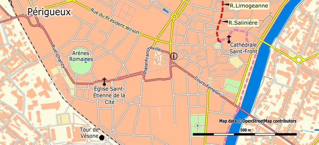
97 97
98 Section 3 Km 70.0 Highest point [6a]. Descent and ascent. Arriving at homes and chalets (new highest point), turn left onto a small road. After 300m: Km 71.5 Leave the GR, turning right (90 ). First up, and then descend to the D710. Cross it, follow it 50 meters to the left, and then turn right into a one-way road. At a bigger road, turn left. After 1 km, turn right into a path, up. Km 73.6 In the hamlet of Les Fieux: turn right and then immediately turn left, between houses, and continue straight on, via a small road, down. Arrive at a road: turn left, towards Km 75.9 Gravelle (W). 100 meters before the roundabout: turn right and cross the D3. Continue opposite, via the road along the river and then along the Canal. At the first bridge: do not cross it, but continue straight on, into a small unpaved road. Km 78.0 Annesse (A in l Eperon 1,6 km off the route) Near the power plant: turn left, cross the canal and then immediately turn right, to cross the River Isle via the bicycle bridge. Follow the «voie verte» track, which turns left at the first T-junction and turns right at the next. Km 80.4 le Perrier [6b] Keep following the «voie verte» along the Lac Bleue, then along the river, and then along the canal. Km 82.5 Turn right onto the D41 turn right, across the canal, direction Camping and then turn right again across the river. Km 83.1 Saint-Astier (A T R). After the bridge a bend to the left and then immediately turn right, up, passing the church, to the Place de l'eglise. Continue straight on via Rue Jules Guesde and Rue Maréchal Foch. At the end of it, turn right on to the Rue Amiral Courbet. At the roundabout: turn left, on to the Rue Maréchal Leclerc, direction Château de Puyferrat. Take the second road to the right, the Rue Eugène Leroy. At a right bend: continue straight on via path. Km 85.1 Château de Puyferrat (H). 3.5 Château de Puyferrat > Mussidan: 23.8 km Km 85.1 Château de Puyferrat. Pass the castle on the right and after it turn right (GR). After 400 meters on to asphalt road: turn right and then turn left to Davalant. Before the hamlet: take the small unpaved road to the left. Km 86.9 In Rougerie (tarmac) turn right, up. After 500 meters, at a T- junction: turn right [7a]. 98
99 99
100 Section 3 Km 87.4 T-junction: turn right. [7a]. After 300 meters: turn left, on to a small unpaved road, to Les Brousses. Cross the hamlet and keep following the small road. Km 89.1 Chassaing: turn left onto the D41 (leave the GR), descending. After 100 meters: turn right on to a small unpaved road and follow it along the forest edge. In Guibaudie: cross the road and continue, passing a house. This small road leads through the woods to "Treillou». Pass the farm, continue to the D41E2, cross it and cross the village of Km 90.4 Saumonie. At the end, take the second small road to the left and continue for 1 km through meadows. Upon arriving at a forest: take the small road to the left, to Km 92.7 Planéze. Turn left and then take the first road right, through the village. Keep following this road straight on (do not cross the railroad tracks), up. After 1 km you will see the GR again [7b]. Continue to Puy de Pont, cross it and at the end turn left, then cross Km 95.1 the D44. Then continue towards Jaumarie and follow the GR via the DFCI (forest road). Km 97.9 Arriving at a bigger road. Turn left. [Attention: Construction work in progress (roads and viaducts) makes actual situation unclear] After 1 km, turn right on to the DFCI (forest road), follow it 700 meters, to another road. Follow this road for 150 meters. At the junction, turn right (leave the GR), <<< It is possible to walk from here via the GR to Douzillac (A) (1 km) >>>. After 150 meters: turn right on the D40, for 100 meters, and then take the small road to the left, descending to Km Les Faures. Turn right and then turn left in the village, onto a small road. T-junction (DFCI): turn left, to arrive on a bigger road. Km Continue opposite, along a new road (DFCI). After 400 meters: intersection. Turn left, then right, and do not leave the DFCI until you reach a larger intersection. After 1 km [8]. 100


101 101
102 Section 3 Km [8], Keep following the DFCI until a bigger crossing. Km Turn left to the D3 (leave the GR again). After 400 meters: turn left, on to the D3 and then right after the railway crossing. Enter St Louis en l Isle. Opposite the church: turn right, in the direction l Hopital. <<At 1 km, straight on, Sourzac (A). Historical pilgrims place>> Follow again the Voie verte, along the railway and then along the river Isle. Km Saint Front de Pradoux. Keep following the Voie verte, cross the D709, then turn right through the hamlet of Tendou. Bend to the left. Near the camp site turn right on the D709 to cross the bridge. Km Mussidan (H W R). After the bridge: turn left and then immediately turn right onto the Place Morant. Continue straight on via the Rue St. George. Pass the Place Victor Hugo (hostel). After 300 meters: cross the Avenue Gambetta and arrive at the church of Saint Georges Mussidan > Sainte-Foy-la-Grande: 33 km Km Mussidan. Church: take the Rue St Agnan, cross the Route de Bergerac and take the street opposite, up. At the end: turn left, into the Rue Beaupuy, then the Rue des anciens d'afn. Junction: turn right into the Rue de Séguinou, up. Km Small road to the right, which arrives at a somewhat bigger road. There turn left. Pass the Cumy farm. The road turns into a forest road (DFCI). Km Crossing: turn right and at the next intersection turn left. The unpaved road turns into an asphalt road. Km Road. Turn left, pass under the motorway, continue, pass the bridge and then turn right, into the hamlet of Les Jaunies. At the bend: follow the small road, 2.5 km, which leads to the D20. Turn left and then immediately turn right. [9a] 102
103 103
104 Section 3 Km Leave the D20. [9a] Km Saint-Géry: church, direction Les Roches. Crossing of the D20. Cross and take the C3. Pass La Caty (ferme auberge / farm accommodation), continue straight on. Km La Gratade (A at 500 meters): Continue straight on to the D13. Cross it, turn left and then immediately turn right, to the village of Km Fraisse. [9b] Near the church: continue straight on, via the C202. Km Crossing of the D20: turn left (careful). After 500 meters, at a crossing: turn right and then turn left, direction Cap Blanc. Keep following this road straight on. Pass a campground, then arrive in the village of Km Monfaucon. [10] 104

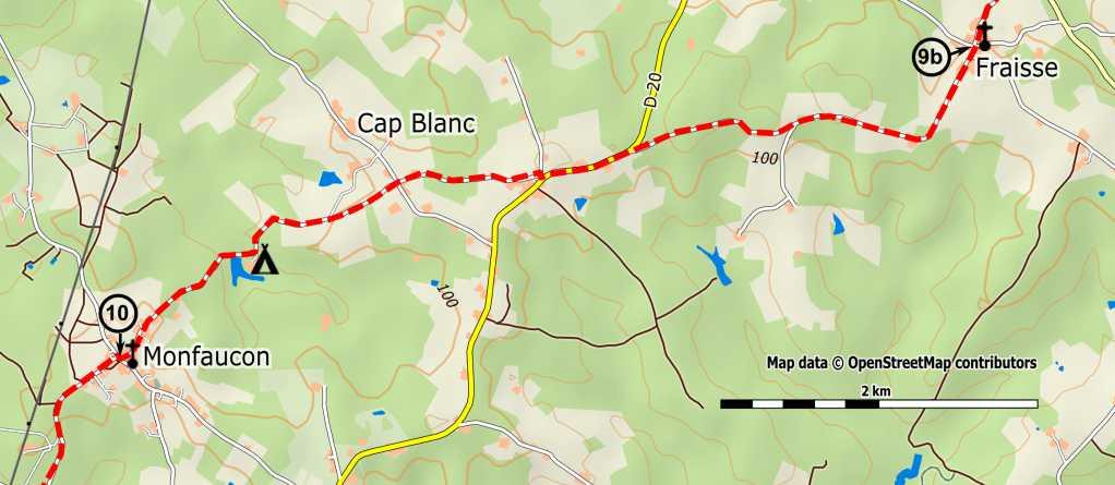
105 105
106 Section 3 Km Monfaucon. [10] After the church: turn right and then immediately turn left. After 1 km: turn left, pass a small bridge, and then turn right at the intersection of Km Virolle. Cross the hamlet of Moncazeau, then cross the D32 and continue opposite via a forest road (DFCI). Crossing of the GR: continue straight on (do not leave the GR until Port Sainte Foy), to Km Cap de Fer. Continue along the asphalt road, for about 500 meters. At the crossing: turn right (A at the first road to the right: Puy Servain). After 1 km: turn left (90 ), into a small grassy road, to the La Rouquette mill (ruin). Km Crossing: turn left, past vineyards. At the end: turn right, descending. Pass a house and branch off to the left, to arrive at a road. Then turn right, up, to the hamlet of Km Briat. Crossing: continue straight on, for about 350 meters. At the bend, opposite: take a small grassy road, descending, between vineyards, to the mill of Km La Feraille (ruin, viewpoint). Continue along the small road. Careful. Steep and dangerous descent to the D20. Cross it, then first turn left, then turn right. Near the Dordogne: turn right, continue along the river, pass under the bridge, and then walk up to the church (next to it is a hostel). Km Port-Sainte-Foy church (C A). On the other side of the Dordogne is Sainte-Foy-la-Grande. To pass on your remarks etc., see 106
107 107
108 Section Sainte-Foy-la-Grande >Captieux Sainte-Foy-la-Grande > Saint-Ferme: 27,8 km The waymarking of this part of the Way of Saint James is provided by the Conseil Général and is fine. Sometimes, a local or departmental walking route is used. In the Gironde, you will see markings on the heads of poles in various colors. You can ignore these different colors and focus on the logo of the Way of Saint James (the European shell: yellow on a blue background), which is fixed on poles and other places. You will also find bronze shells, in cities like Pellegrue, La Réole and Bazas. Km 0.0 Sainte-Foy-la-Grande (I H B V T W R). Cross the Dordogne via the D20 [1], the Pont Michel de Montaigne. Here you cross the departmental border of Dordogne and Gironde. Halfway a sign of the Voie de Vézelay indicates: "Compostelle (Santiago) 1100 km". Continue via the Allée M. de Montaigne. Km 0.2 The Allée leads to the Avenue Ithier Gorin (D130). (To the left is the center with the town hall, the tourist office and a church). Turn right. Near the cemetery the Avenue becomes the Avenue du Maréchal Leclerc and leads to a crossing with the D936 E6 (Castillon La Bataille - Bergerac), traffic light. Km 0.4 Follow this avenue (D672) for 2.7 km, direction La Réole, South West. (Good, wide shoulder). Pass under the railway bridge (0.65 km), and then under the ring road around Sainte Foy la Grande (1.4 km). Leave Pineuilh (B V), cross the hamlet of Le Chantier (2.2 km). Km 2.8 Arriving in Pont-de-la-Beauze (municipality of Saint-André-et- Appelles) (Eynesse H). Km 3.0 Keep following the D672, direction South East. Along the town hall and a monument to Jean Blondel. Careful: the road is busy and the roadside narrow. Km 3.2 Arriving in the hamlet of Les Caris: leave the D672 and take a small gravel road to the right, up (dead end). (B in Les Chapelains - 2,5 km not on the route). Km 3.3 Keep following the small road, which becomes grassy (direction south-southwest). At the top: small curve to the left, down. Then a curve to the right (direction south-south-west), up, to the hamlet of Le petit Montet, where the small road is paved. Km 4.2 T-junction: turn right (due west). [2] 108

109 109
110 Section 4 Km 4.2 T-junction: turn right (due west) [2] and follow the small winding road between villas (ignore various roads from the right), and continue through vineyards and orchards. Km 4.9 T-junction: follow the small asphalt road to the right, direction St.- Quentin-de-Caplong (sign of the Way of Saint James), west-north-west. Km 5.1 Church of Appelles, surrounded by a cemetery, curve to the left (direction west). Magnificent views over the Dordogne and the slopes on the right bank. Km 5.2 The small road leads to the D130 E8 (wooden road cross), height 103 meters. Turn left, direction due south. Km 5.7 At the next junction: take the D18 to the right (direction north-west, to Gensac). Km 6.9 At the «stop»: go diagonally left (D18, direction due west, to Gensac and Pujols) and follow this road for 0.6 km. Km 7.5 After crossing the river: leave the D18 and turn left, onto the D235, direction Lèves and Thoumeyragues (GR 654), due south. Note: the sign with a Saint James marking, to the right after the bridge, indicates: «St Quentin Caplong at 4.7 km». Do not follow this, as this route is not well marked. Follow this road for 900 meters, through the valley of the Gravouse, along the river (on your left). Km 8.4 Take the first road to the right, direction La Bonnetie and Les Saurins: sinuous, up (30 meters), no views (direction northwest), to the first-mentioned hamlet (visible from the bottom of the valley). Keep following the small road. Km 8.8 At the crossing: continue opposite (due west), direction the castle of Bonnetie haute (GR marking, Saint James marking: Saint-Quentinde- Caplong at 3.8 km). After the castle: continue straight on, cross the yard, take the dirt road and after 20 meters: Km 9.3 Turn to the left, along the power line (direction south-south-west). A soggy road between vineyards. Keep following this direction, pass under the power line, which branches off to the west. Km 10.1 Cross a small asphalt road, continue straight on. The small road becomes stony. A mast of a power line on your right. The small road becomes soggy again, leads through a small grove, turns left along a vineyard and then along buildings, and then arrives at a small asphalt road to Vergnet, Les Saurins and the Château Lagrange. Keep following this direction for about 50 meters, south-west. Km 10.8 Crossing with the D128: turn left to La Taillade, direction due south; leave La Tour rouge, Monlar and Belair to the right. Keep following the D128, which is now heading south-west. Km 11.5 At the «stop», roadcross to the left, continue in the same direction 110
111 (Saint-Quentin-de-Caplong 1 km), with the church tower of Saint- Quentin in sight. Leave La Taillade on your left. Km 11.9 Before the village of Saint-Quentin-de-Caplong: turn left, towards Les Foucauds and Saint Pierre. Follow this small asphalt road to the end, at the D128 E9. While descending, leave the GR654 near Les Foucauds, by branching to the right, (unless you want to enjoy the beautiful view of the Valley of the Soulège, near the church of Saint- Quentin). Km 12.6 At the "stop": turn left. Here you'll also find the GR654 again, which has gone around Saint-Quentin. Cross the small stream, leave Le Breuil on your left, and walk up to Caplong. Km 13.0 Arriving at the kerk of Caplong (H, in La Tour, not on the route), keep following the D128. Km 13.2 At the stone roadcross: take the road to the right (direction west, to Le Tertre, La Roque and Massugas) [3], thus leaving the GR654, which again makes a small detour). Leave Le Tertre to the right. Km 13.7 Before the poplars and the small bridge: branch right via a small asphalt road (marked with a shell and an outdated plate «Gîte Roquebrune"), direction north-west. [3] (You'll see the GR again). 111
112 Section 4 Km 13.7 Before the small bridge head north-west. [3] Ignore the yellow cross, remnant of an outdated marking. Walk along the stream (the Soulège), cross it, and go up, along farms (first left, then right). Km 14.7 At the next crossing: leave the direction Courret Sud and turn left, up (direction south-south-west). You arrive at vineyards. Keep following this small, winding road, which bends to the south-west. Leave Le Grand Plantier on the left. Km 15.9 At the "stop" (= D233): continue opposite (direction Vignobles Cardarelli, Château Pierron). Leave the hamlet of «Lieumenant» to the right, and then the Vignobles Cardarelli to the left, and continue straight on. << Sign «Halte pèlerins" (accommodation for pilgrims), near the crossing of Borne Nord: this is not correct. >> Km 17.3 At the «céder le passage» (yield) (= D233 E1): keep following the direction west-south-west, to the castle of Cazette. Leave that at your right. Leave Chazelle to the left. Km 18.9 At the «stop»: leave the direction Massugas and descend to the left (sign GR654 and marking Saint James: Pellegrue 3 km), direction southsouth-west, which you keep following to Pellegrue. Leave Cutour to the left, and then Cansac to the right. Ignore yellow markings. Leave «Les Bailloux» to the left. Km 20.8 Sign Pellegrue. Km 21.2 Crossing with the D16 E1 (direction Gensac, Castillon): continue opposite, up, into the Rue de la Poste, to the post office. Take the Rue du Vallon to the left. Km 21.3 Pellegrue (I H K E W) Place du 8 mai, with a remarkable hall. Km 21.4 Pass the chruch, walk around it and turn right. Km 21.5 Take the Rue du Champ d'eymet to the left (follow the sign «Chemin de Compostelle»), pass the cemetery, then turn right, a nice descent. Km 22.0 Continue straight on. << for variant via GR see box >> Variant via GR after Pellegrue, 700 meters longer, but along dirt roads and more shade. Km 22.0 The GR turns left, via a grassy path. Km 22.6 Bridge over a creek, then up through woods and vineyards. Km 23.6 The path becomes a road. Km 24.8 T-junction, follow the GR marking to the right. Km 25.3 You are back on the main route at Km Warning: the way marking can be confusing! 112


113 Km 22.2 Cross a kind of a stream. The road goes up again. Km 24.6 Leave the road and take a path to the right, through the vineyards. You are back on the GR. Continue straight on, into a small forest. [4] 113
114 Section 4 Km 25.5 Cross the small forest [4] and leave it via a small road. Km 26.4 Turn left to the hamlet of La Vergne. Km 26.9 Crossing with the D139: turn right. Km 27.8 Crossing with the D127: continue straight on, for around 30 meters and then turn left (follow the sign Way of Saint James). [(H B W) in Saint-Ferme, at 200 meters] <<The nearby former Benedictine Abbey of Saint-Ferme is worth visiting >> Saint-Ferme > La Réole: 19.2 km Km 28.2 Leave the road and take a small road to the right, marked by a sign of the Way of Saint James and a stone road cross. (If it rains this small road is rather slippery). Km 29.0 The small road goes between two hedges and then through vineyards. Contiue straight on. At the end: turn right on the D16. Km 29.2 Soon after: turn left, onto the D126, direction Couture. Km 31.1 << To the left is a variant via Monségur - see box. >> Km 33.3 Cross the D230. Km 34.5 Cross the D15, to the church. Km 34.7 Coutures (BV) Pass the church and the cemetry. [5a] Variant via the fortified bastide Monségur, with all services, along the GR Km 31.1 Turn left, into a small road with GR marking, towards a wind mill. Km 31.9 Near houses: take the small road to the left. Km 32.1 Take the small road to the right, which later is asphalted. Km 33.2 At the junction: turn right. Km 33.5 At the crossing («stop»): turn left. Km 34.1 Bordepaille. At the «stop»: turn right onto the D16. Careful: fast driving cars. Km 35.0 Cross the Dropt. Km 35.2 Do not follow the GR to the left, but continue to the "escalier the verdure "(a path, with beams as stairs, to the left of the road): take that, up. At the top: take the street opposite. The main square of Monségur is on your left. Km 35.5 Monségur (I A B T E W) All shops and services. Take into account the Sunday closure! To be continued in the box on the next page. 114


115 115
116 Section 4 Km 34.7 Church and cemetery of Coutures (B V). [5a] Km 34.8 Follow again the D126 and cross the bridge over the Dropt. Km 35.9 Cross the D668 and follow it for about 30 meters to the right. You then leave the ruins of Cazes castle behind you (on the left). After crossing the bridge over the Andouille: take a small road to the left. After 500 meters, at a crossing: turn right and walk to Roquebrune. Km 37.9 Roquebrune (B V). T-junction: turn left. <<100m to the right is the church and the town hall (a former Commandery of Knights Templar) >> Km 38.5 Crossing: take the road opposite, direction Lage (yellow marking behind a traffic sign). The road goes up, through a small forest. Km 39.5 Continue straight on. The GR turns left here, to make a big detour. Km 39.9 Sign of the hamlet of Bigat. [5b] The road still goes up. Continue straight on, following the marking Way of Saint James (shell on blue background). Km 41.5 Arrival in Saint-Hilaire-de-la-Noaille. (B V A) Km 41.8 At a bigger crossing («stop»), near the hamlet of Le Pont: turn right (D129). Sequel variant via Monségur Km 35.5 To leave Monségur: take the Rue Porte de La Réole. Follow it to the end. Km 36.0 You arrive at the ring road around Monségur. Be careful: little visibility to the left and speeding cars! Km 36.1 Cross the crossing. Km 36.3 Take the road to the left to Bénézit, Neujons, with GR marking, slightly up. Hospital on your left. Km 37.7 At the top: note, take the small road to the right, along vineyards. You will see a yellow marking about 10m before this small road and a marking «change of direction» about 10m after you entered the small road. So, actually, these two markings are interchanged. Continue straight on, through meadows and vineyards. Km 38.7 At the crossing (road cross): turn left. Km 39.4 Farguet. At the crossing: turn right. Km 39.5 Arrival in Saint-Sulpice-de-Guilleragues. Km 39.6 Leave the castle of Saint-Sulpice to the left. Km 39.9 Turn 90 right, leave the church and the cemetery to the left. Km 40.2 At the crossing: turn left and descend to the D668. Km 41.4 Follow the D668 to the left, for about 250 meters, and turn left after the small bridge. Km 41.7 You are back on the main route, at Km

117 Km 42.4 The gîte of La Peyrière is on your right (B). Take the small road opposite, which soon afterwards turns right. On a larger road: turn left. [6] 117
118 Section 4 Km 43.1 Follow that larger road, direction south-west. [6] Km 45.1 Follow the marking Way of Saint James (big bend to the right, then to the left) to the access road to La Réole, which you follow to the right, to a roundabout at the entrance of La Réole. Km 45.6 At the roundabout: take the second road (wooden sign with shell). Continue straight on, entering La Réole. Km 47.0 La Réole (A E B W I R) Church and town hall La Réole > Bazas: 36,8 km Km 47.0 La Réole. From the church: Walk along the park and the lyceum and then go down the stairs to the quay of the Garonne and the bridge. Km 47.7 Cross the Garonne (marking Way of Saint James). Km 47.9 Stairs to the right, descend and follow the dike. Km 48.1 Arrive at the D12. Leave the dike. Km 48.3 Marking Way of Saint James, indication «Moulin de Piis» (H). Turn right. Km 50.8 Floudès. Turn left, direction Bassanne (marking Way of Saint James). Km 51.1 At the church: continue straight on, ignore small roads from the left. Km 53.0 T-junction. Turn right (RP at 500 meters) and enter Bassanne (H on 500m). Km 53.2 Bassanne. Roundabout: take the D226 E1 to the left, direction Puybarban. Km 53.8 Cross the canal. Fontain on your left, before the bridge. Km 54.0 Arrival at the D224, continue straight on, direction Pondaurat. Km 54.2 Arrival at the D225: take the small road to Pondaurat (A). Km 55.9 T-junction. Fountain (drinking water). Take the D12 to the right, direction Auros. Km 56.1 Pondaurat. Turn right after the bridge and follow the marking Way of Saint James. Km 57.0 Turn right, direction Bardasse (marking Way of Saint James). Km 57.5 Cross the bridge over the highway. [7a] 118

119 119
120 Section 4 Km 57.5 Bridge over the highway. [7a] Km 58.6 At the sign «Espagnoulet": turn right. After 300 meters, near the hamlet of Hum, in a right-hand bend: leave the road and continue straight on, via a small grassy road. Km 59.7 Near the castle of Bonnegarde: turn left, towards a T-junction with the D9. Turn right. Km 60.1 Savignac (W). Turn left and walk up to the church, following the marking Way of Saint James. Not along the route: after 4 km, direction Langon, via the D 116, is the Abbey of Sainte Marie du Rivet. (C V). Follow this small road. Km 62.9 Near the hamlet of Le Juge: leave the small road and turn right, up, via a small path through the undergrowth. Km 63.7 Leave the forest, marking Way of Saint James, hamlet of Haubet. Turn left. Km 65.2 Small asphalt road, hamlet of Canteloup. Km 66.0 Hamlet of Mussac. Km 66.8 Arrive at the D15. T-junction, turn left. Km 67.4 Auros (H E W) pass the church to the right and follow the small road. Km 67.7 Just before the cemetery (water tap left after the entrance): turn left, down, via a small earthen road, pass the pigeon tower. Km 68.6 Small bridge over the Beuve. If it rains a lot, parts of the path are underwater. If that's the case: avoid this part, by following the stream to the left, to the road. Turn right into a small road. Km 68.9 Pass a small road to the left, to the hamlet of Le Parc. Km 69.2 T-junction: turn left. Marking Way of Saint James, follow the small road. At the first T-junction: turn right (hazel bush) [Pruera (A) at a little more then 1km]. [7b] Km 72.0 Brouqueyran (H V). Turn left onto the D125. Km 72.6 Turn right, to the lake and walk around it on the right side (marking). Km 73.5 A small bridge, turn left: after the bridge you are back on the (marked) path, which you follow along the lake. If it rains a lot parts of it are underwater. Km 73.9 Turn right, up. Km 74.1 Pass a pigeon tower. (Careful during the hunting season from 1/10 until 20/11, make sure people hear you coming). Km 74.2 Pass the corridors of the pigeon tower. Km 74.8 Hamlet of La Borde. Km 75.0 Asphalt road. Hamlet of La Mongie. Keep following the road. 120

121 Km 75.3 At the crossing: turn left. (Markings Way of Saint James and GR654). Km 76.4 Hamlet of La Niac. Km 77.3 Turn sharply right, onto a small road. Km 78.2 On the D123: turn left. [8] 121
122 Section 4 Km 78.2 D123. [8] Km 80.0 Small road, turn right. Hamlet of Lagardère. Km 80.9 Turn left (follow the sign «Voie Verte»). Km 82.2 Hamlet of La Serre: turn left, a bike path (marking). Km 83.1 Arrive on the D655. Turn left, towards the cathedral of Bazas). Km 83.5 Cross the D655. Rue Pallas, towards the cathedral. Km 83.8 Bazas (I A H B T E W). Cathedral Bazas > Captieux: 17,3 km Km 83.8 Bazas. With your back to the cathedral: cross the square, pass the Tourist Office, and take the Rue Saint Martin to the left (bronze shells on the ground). Continue via the Rue du pont des Arches, following the markings Way of Saint James. Km 84.4 Cross the D932 E9 and take opposite the Avenue Franck Cazenave, towards the school and the college Ausone. Km 84.9 After the gymnasium: cross the former railroad crossing. (GT) Follow this former railroad to the left (markings Way of Saint James). << For variant via Bernos-Beaulac see box >> Keep following this railway almost always, until Captieux. Km 85.4 Obstacle: the former railroad is cut, there is no bridge. A marked passage to the right leads down to a trickle and then up again (very slippery when it rains, but a wooden handrail ensures safety). Km 85.8 Junction with the N 524 cross carefully and go straight across from there on. Variant Bernos-Beaulac, 3 km longer, but less monotonous. Km 84.9 After the gymnasium: crossing with the former railroad. Leave the marking by the Conseil Général and continue straight on. At the right you see a yellow marker, left the gîte of Claire-Feuille. (B). Keep following this road and cross a little bridge (km 1.6). You arrive at a T-junction, indicated by a "stop" sign and a yellow marker. Km 85.5 Turn left. Km 85.9 At the left you see a small statue of Mary. Continue, pass under the ringroad around Bazas. Km 86.2 Keep following this smaller road, which bends to the left, direction Calonge-Les Charmettes Km 89.1 After the bridge over the highway: continue towards Bernos, the road bends to the left. Leave the direction Marimbault to the right. Keep following this smaller road for 1 km, to power lines. See further the box at the next page. 122


123 Km 87.3 Again junction with the N524 (carefully). Km 88.3 Crossing, markings, go straight across from there on. [9a] 123
124 Section 4 Km 88.3 Crossing. [9a] Km 89.1 Crossing, markings, continue opposite straight on. Km 89.5 Obstacle: the former railroad is cut, there is no bridge. A marked passage to the left leads first down and then up again (very slippery when it rains, but a wooden handrail ensures safety). Km 91.1 Bridge over the highway A65: turn left after the bridge, then a bend to the right. Km 91.8 Obstacle: the former railroad is cut, there is no bridge. A marked passage to the left leads first down and then up again (very slippery when it rains, but a wooden handrail ensures safety). A few meters further: bridge over the Ciron. Km 92.6 Crossing the N524: cross carefully and continue opposite straight on. (The variant from Beaulac arrives here on the main route). After 2 km [9b]. Km 97.4 First crossing of Londeix, small road to the left. Km 97.5 Second crossing of Londeix, small road to the left (B). Km 99.0 Crossing the N 524 (carefully): Follow the emergency lane and, after a wooden squirrel, cross the N-road. Continue opposite via the former railway (marking). Sequel variant Bernos-Beaulac Km 90.1 Power lines. Follow this road another 1,8 km. Km 91.9 T-junction, marked by a watertower on the left. Turn left, 200 meter, until a T-junction. Km 92.1 T-junction: turn left. A little further is the entrance to Bernos (km 8.6). Right you see the church tower of Bernos. Km 92.8 Bernos (A V B W) T-junction: turn right, towards the church square. Keep following the road, along the hill, until a crossing marked by a "stop" and a small road cross on a stone pedestal. Km 93.3 At this crossing: continue opposite, direction the gîte of Bacourey (H). After 270 meters: pass the barrier ("barrière") and descend to the gîte and the Ciron. Cross the small bridge over the Ciron and walk through undergrowth, up, to an asphalt road. Km 93.9 Take this asphalt road to the left, to Beaulac. Km 94.2 arrival on the N524, with the bridge over the Ciron on the left and a bakery on the right (open from 6:30 to 13:30 and from 15:00 to 17:00). Turn right, pass the pharmacy and the bus stop of the Trans-Gironde and continue carefully along the N-way. Km 95.1 Opposite a former railroad crossing and the exit of a cardboard factory you are back on the main route of the Voie de Vézelay, at Km
![Km 100.0 Arriving at a gravel road, follow this [west of the D524 (B V)]. Km 100.](/docs-images/92/110863197/images/125-0.jpg "4 In the bend to the right: continue opposite, via the small road. Km 100.")

125 Km Arriving at a gravel road, follow this [west of the D524 (B V)]. Km In the bend to the right: continue opposite, via the small road. Km Take the earthen track to the right, towards buildings, leave the station of Captieux to the left, and then turn right, towards the church tower. Km Church and town hall of Captieux (H B V K D W). 125
126 Section Captieux > Sault de Navailles Captieux > border of Les Landes: 12,5 km Km 0.0 Church of Captieux: follow the direction of Maillas N524. [1a] Km 0.6 Turn right before the former railway guard house N 41 and keep following this unpaved road straight on (former railroad). Km 3.0 Hamlet of Rivedieu to the right (B). Km 6.0 Cross an unpaved road Le Billon. After 3 km [1b]. Km 9.9 Arrive on an asphalt road, turn left. Km 10.8 Cross the highway via a bridge, turn right and follow the unpaved road along the highway. Km 12.5 Arrive in Les Landes, near the sign of the «Voie de Vézelay». Take the unpaved road to the left. 5.2 border of Les Landes > Bourriot: 8,5 km Km 12.5 Near the sign of the «Voie de Vézelay»: take the unpaved road to the left (former railway). Km 14.1 Careful: arrival on an asphalt road. Follow this 300 meters to the right. Km 14.4 Near the big barn of Saus de Bas: take the road to the left, before the transformer. Km 17.0 Pass the farm of La Plante, after 500 meters the farm of Grand Loucaucous, and after another 500 meters the poultry farm of Petit Loucaucous. The road makes a right turn here. Km 18.3 Careful, in this bend: leave the road to the left and take the dirt road through the forest, direction south. After 400 m you arrive at the farm of Petit Bétéra. Km 18.9 You walk on private property. Beyond the houses: turn right on to the dirt road to the stream Pouchiou, a little further. Approximately 20 meters before the stream, at the right, is a source and a small statue of Mary. After crossing the stream you see a beautiful water reservoir. 50 meters after the stream: take the dirt road to the left, Chemin du Pouchiou. Follow this south south-west. Pass a poultry farm. Km 21.0 Arrive on the D24. [2] 126


127 127
128 Section 5 Km 21.0 On the D24: turn left [2], to the village of Bourriot Bourriot > former station of Retjon: 5,9 km Km 21.0 Church of Bourriot (B): Take the D224 to the right, direction Retjons. After 200 meters: turn left on the CD 379, towards Saint-Gor. After 500 meters, down, you cross the stream Le Lugaut. After the stream the road goes back up again, for about 400 meters. Km 22.2 Attention, at the top: leave the road, to the right, and take a dirt road. After 1 km this takes you to a junction: take the road to the left (south-east). Km 23.8 House on your right. Crossing: take the dirt road to the right, former railway. Km 24.6 Cross the bridge over the stream Le Lugaut. Km 25.2 You arrive at a major, very well signposted, crossing. To the left is a small chapel, a visit is certainly worthwhile. Continue direction Roquefort, along the former railway. Km 26.2 Cross the stream Le Retjons via the bridge La Moulasse (along the stream is a picnic area). Km 26.9 You pass the former railway station of Retjons (B) (possibility of tap water). Immediately after the building: cross an asphalt road. Continue straight on via the dirt road Former station of Retjons > Roquefort: 7,3 km Km 26.9 Cross the stream Ribarrouy. Continue straight on. Km 28.9 Arriving on an asphalt road. Continue opposite, diagonally left, direction Lagune de Nabias. Km 29.2 Turn right, on to a grassy path.. Km 30.3 Arriving on an asphalt road. Follow it for 20 meters and then, before the railway guard house, take the dirt road to the left. Km 31.3 Take the dirt road to the left. Km 31.7 Opposite an empty hangar: take the dirt road to the right. [3] 128


129 . 129
130 Section 5 Km 31.7 Opposite an empty hangar: take the dirt road to the right. [3] Km 32.4 Take the dirt road to the left. Km 32.7 After the «base nautique»: arriving on an asphalt road (opposite: a small building), turn right. Km 33.1 Turn left and then immediately turn right, into a dirt road. Km 33.5 Arriving on the D932. Turn left at the «stop» and after 50 meters turn left again: Chemin de Coupet. Km 33.7 Cross the small bridge over the stream L'Estampon. Once back at the top: arriving in Roquefort, Place Georges Lapios. Continue, straight on, via the Rue Port Lang. Km 34.2 Arriving at the church of Roquefort, Rue Gambetta (H) Roquefort > Bostens: 8,3 km Km 34.2 From the porch of the church, go through the gate. Then turn right, into the Rue C. Hubert Crohare. Slightly further is the Place des Cagots. Descend from there to the bridge over the Douze (the so called «pont gothique» = Gothic bridge). Nearby, right, on a tower of the former castle, is a beautiful view point. Continue via the Rue Penecadet up, for about 100 meters, to the big bend to the right. After the bend: take the the stairs left, called "Boque": several steps, to the D932. (The pilgrim in a hurry can walk straight ahead and save 500m). Cross this road and take the dirt road, called "Brunot." Follow it for about 40 meters, up. You arrive at a small asphalt road (Chemin du Pouy). Take that to the right, and follow it for 200 meters, to a junction called "caserne". Take the D 934 to the left: Route de Pau. Follow it for about 100 meters, cross and take the small asphalt road to the right (Chemin de Bostens). Follow this until a bridge over the ring road around Roquefort. Turn immediately right, along the ring road. Just before the big road: turn left, into the Chemin de Balloche, which becomes a dirt road and then joins the D932. Take the D932 to the left. After 300 meters: arriving at a former railway crossing. (Here the pilgrim in a hurry joins the route). There is not much left, except the railway guard house. Km 36.9 Just before the former railway guard house: turn left onto the C101. After 30 meters: turn right, into a dirt road through the woods. Continue straight on (south), ignore paths from the left and right. The road becomes more and more overgrown with grass. At a junction: keep left. Arrive at some sort of dike. Follow this for 300 meters, to a small road which is perpendicular to the dike. On the left: the gate of a private property. Turn right. 130
.")

131 Km 38.7 Attention; after 50 meters: turn left (south), into a small road that goes up very slightly. The small road very soon becomes more of a dirt road and passes a house (on your left). The road descends, following a power line, and increasingly becomes a dirt road. Soon after you see the houses of Corbleu. Km 39.7 Arriving on the asphalt road: continue straight on (south), to the church of Corbleu. Pass the cemetery. Descend to the small bridge. [4] 131
132 Section 5 Km 40.1 Cross the small bridge [4], ignore the road to the right, and continue, up. (In fact, you continue on this road until Gaillères). At the crossing of Garroua: continue straight on, through the pine forest. Km 41.5 Crossing over the Route de Pouydesseaux: continue straight on, direction Bostens. (After 80m turn right for HV in Larousse). Km 42.5 The church of Bostens. Well worth a visit! In the church is a place for pilgrims with coffee/tea. Ask for the key at the house opposite Bostens > Bougue: 9,5 km Km 44.8 In Bostens: continue straight on, direction Gaillères. 800 meters after Bostens: a crucifix (left), and very nice and old oak trees along the road. Continue in the direction of Gaillères, approaching the Route de Mont de Marsan near Houeillès (D933), while leaving the forest behind. Crossing over the D933. Watch out! Take the D933 to the left, but then immediately turn right, direction Gaillères (KVW). Km 45.8 Church in Gailleres: on the wall of the church is a route marking. The window above it represents Saint-Jacques (Saint James). At the junction at the church: turn right and immediately left, direction Bougue (passing the water tower). After 500 meters: Le Chemin Vert (H). Km 48.9 Cross the highway. Continue southbound direction, Bougue. So do not turn right, towards St-Avit. Km 49.2 [5a]. 132
133 133
134 Section 5 Km 49.2 [5a]. Km 51.2 Cross the bridge over the Midou. Km 52.0 Arriving in Bougue (H), descending. At the crossing with the Route Mont-de-Marsan, near the wash-house: turn left, towards the promenade between the "salle des fêtes" (= feast hall) and the church. Please ask at the bar for access to the gîte (hostel) Bougue > Mont-de-Marsan: 10 km Km 52.0 Depart from the village square of Bougue. Head towards Laglorieuse (sign Michelin). After about 500 meters: a crossing with a bike path (railway guard house on the left). Km 52.5 Turn right onto the bike path, which you follow to Mont-de- Marsan, ignoring all kinds of roads from the right and the left. Keep left, in relation to cyclists coming from behind. Km 55.3 After 2,8 km on this bike path: a crossing (direction Beaussiet to the right and direction Mazerolles to the left). Continue straight on. After 1,2 km: pass under the ring road. [5b] Km 58.0 Arriving at another crossing (direction St-Médard to the left). Continue straight on, you cross a suburb of Mont-de-Marsan, with villas on both sides of the bike path. Km 58.8 After passing two more crossings, you arrive at another crossing, with the Avenue de Lacrouts. From this crossing you will see the bell tower of the Romanesque church of Saint-Médard. Keep following the bike path. Km 60.5 Crossing with traffic lights (Boulevard du Chemin Creux). Turn right, cross this boulevard and then cross the Boulevard d'alingsas. Continue straight on via the Boulevard Jean Larrieu, to the Avenue Eloi Ducom. Turn left there. Continue towards the center. At traffic lights: turn diagonally right, into the Rue Lesbazeilles. Km 61.0 In front of the pilgrims' hostel (H R). Follow the information on the door for the key. A pilgrims pass is obligatory. To leave the city, from the hostel: continue along the Rue Lesbazeilles, to the Rue Gambetta. Take this road to the left. Further on the Avenue Sadi Carnot. After the roundabout of Avenue Kennedy: continue straight on, direction Grenade-sur-Adour. Km 62.0 Cross the Boulevard Antoine Lacaze and the railway. [6] The oldest part of the city is located north of the route, between the Le Midou and La Douze rivers, which come together here in La Midouze. Definitely worth a short visit! 134

135 135
136 Section Mont-de-Marsan > Benquet: 7,3 km Km 62.0 After the railway [6]: continue along Avenue Kennedy, straight on, gradually leaving the center. Km 64.0 Roundabout (after 100 meters you see another roundabout): Turn right, into the road direction Saint-Pierre-du-Mont (D 321). After 150 meters: take a road to the left, with a sign "Lareigne". You pass under the ringroad. Keep following this road. Km 65.3 After passing two houses on your left and then a house on your right, you arrive at the end of the road. Continue straight on, via a gravel road and then a dirt road through a forest. After 600 meters: arriving at a cross road, turn right. Attention: after about 250 meters, take the first dirt road to the left. Keep walking through a pine forest. Km 67.0 Arriving at an asphalt road: turn left, and keep following this road straight on. At a crossing: again straight on. You pass a pharmacy and then the church of Benquet village. Continue straight on. Km 69.3 Benquet Benquet > Saint-Sever: 12,7 km Km 69.3 At the end of the village, you pass the schools. A bend, then a roundabout: turn left, direction Saint-Maurice. After 900 meters: a crossing (Route Loustaou), continue straight on. After 300 meters: pass the church of Saint-Christau, and after 1.3 km another crossing (Route du Catalan). Continue in the direction of Saint- Sever. After 700 meters: another crossing (Chemin du Parroc). Keep following in the direction of Saint-Sever. Km 73.3 Crossing (Chemin du Coye): continue straight on, after 700 meters another crossing (Chemin de Laouzère). Attention: turn right, into the Chemin de Laouzère in. [7a] 136

137 137
138 Section 5 Km 74.0 Chemin de la Louzère. [7a] Keep following this small asphalt road. After 400 meters, in a sharp turn right: take the dirt road opposite and follow this for about 2 km, to a cross road with gravel. Take this to the left and continue until an asphalt road (house). Km 77.3 (Attention, unclear indicated!). Take the small asphalt road to the right and follow it for about 1.5 km. Then you see a roundabout. 200 meter before it: take a small, marked road to the left, which leads to a new road. There turn right. Cross the D924 (careful, a lot of traffic). After 150 meters: arrive in Sainte- Eulalie. Km 78.8 In Sainte-Eulalie: continue along by the church, toward the terraces of Sainte-Eulalie. Follow this road along the river, passes under a railway bridge, and arrive at the bridge over the Adour. From the bridge the route through Saint-Sever is marked with bronze shells on the ground. Cross the bridge. Follow the shells, up to Saint-Sever, and its abbey from the X century. At the abbey (opposite the Tourist Office): take the Rue des Arceaux to the left and continue straight on via Rue du Général to Lamarque to the Cloître des Jacobins, where the pilgrims' hostel (H) is Saint-Sever > Hagetmau: 16 km Km 82.0 From the Cloître des Jacobins: continue via Rue du Général Lamarque and then Rue de la Guillerie. At the end: turn right, to arrive at the crossing with Route de Montaut (traffic lights). Turn right, onto Boulevard de l'espérance. After 300 meters: turn left (at the «centre de loisirs»), follow Chemin de Laburthe. After 900 meters: turn left into Chemin de Laboye (gravel road), near a water tower. Follow this Chemin. After 1km [7b]. After 300 meters: a cross road, Chemin du Barthe. Turn right here. After 300 meters: arrive at another crossing. Turn left here, direction Chemin the Pugnerette. Km 84.0 Keep following this road, until a bridge over the stream Gabas. Km 86.0 Cross the bridge. Continue along the asphalt road, which heads south, and leave a nice mill and then a pump station at your right. After about 200 meters: the road crosses the (mill) stream. After 100 meters: leave the road, turn right, cross the railway and then take immediately left the small road along the railroad. The road is first asphalted. Attention: leave the tarmac at the zone of the first house and take the dirt road along the railroad. Shortly after the small road passes along the stone railway bridge. [8] 138


139 139
140 Section 5 Km 87.7 Near the stone railway bridge [8] the small road runs along a stream (the Laudon), and then crosses it near Audignon. Km 88.0 Arriving on the D21, Place Compostella (roadcross left). Follow the D21 and D78 in the direction of Horsarrieu or.... Turn left, cross the railway and immediately turn right on to a small road (Chemin du Carrerot). After 50 meters, at a junction: take the road to the right (Chemin du Campagnon). Shortly after the small road is unpaved, and continues along a ditch. After 400 meters: arrive on a small asphalt road. Take that road to the right, towards the railway. Cross it and then the stream (the Laudon), and continue to Route d'horsarrieu, after 50 meters. Km 89.0 Take this road to the left (D78). The railway remains in sight, to your left. The road goes up slowly and serves some farms. At the top of the hill, at the location of a crucifix: turn left, direction Chemin du Camps, via a small road that descends to the railroad. Km 91.0 Pass under the railway bridge. The small road goes up again, to a crossing with a crucifix. Continue straight on, again passing under the railroad. The road gradually descends. You will see Horsarrieu, on the hill, in front of you. A crossing: continue straight on, up, against the one-way traffic. Arriving almost near the village church. Km 93.0 Cross Horsarrieu, via the Rue St.Blaise, direction the D78. This road brings you to Hagetmau. Km 95.0 On the roundabout at the entrance of Hagetmau (H): turn right, direction Orthez. << For a shorter route through the center, see box. >> Attention: 100 meters after the roundabout turn left (Ets Capdevielle). The road descends towards the crypt of St.Girons. At a «Stop» << 150 meters on the left: the crypt of Saint Girons >> continue straight on, via a small road, that descends to a second "Stop" (near a bakery). Turn right and then turn left immediately (direction industrial zone). Then continue straight on, passing the municipal slaughterhouses and then Etablissements Muller, to arrive on the main road, near the bridge over the Louts. Immediately after the bridge: take the path along the river (upstream). Km 98.0 After almost 1km: arrive at the bridge of the D933, at the exit of the small town. [9] From the roundabout at Km 91.8 you can also continue straight through the center to the bridge of the D933. Then you will pass shops. This variant is not marked and 1.2 km shorter. If you intend to get the key to the hostel by the swimming pool: the pool is in the center and the hostel direction Saint Girons. 140

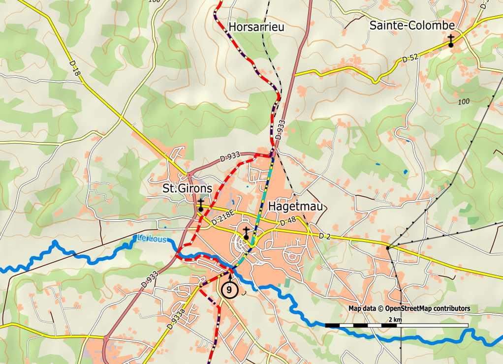
141 141
142 Section Hagetmau > Sault-de-Navailles: 14 km Km 98.0 Bridge of the D933 Bridge over the River Louts [9], leaving Hagetmau: continue along the D933, slightly up, to the top of the hill. There take the small road to the left (Chemin de Lafargue), which after 300 meters crosses the D357 (Route de Labastide-Chalosse). Take the D357 to the right. Km 99.0 From that crossing to Argelos you mostly follow the D357, except the shortcut in Labastide-Chalosse. Continue heading south, direction Labastide-Chalosse. At a junction (indication "quartier de Coupés»): keep to the right. Continue along the D357. Km Crossing of a stream. Continue along de D357. Km Arriving at the crossing with the Route de Momuy. Continue along the D357. Soon you will see the church tower of Labastide- Chalosse. Km Church of Labastide. 200 meters after the church: take the small road to the left, windy, significantly descending. After 400 meters through forest: arrive on a wider road. Take that road to the right and arrive again on the D357, left, direction Argelos. The road follows the bottom of the valley; forest left, fields right, until the bridge over the Luy de France. Km Bridge of Luy de France. Cross the bridge. The road goes along a sidestream of the Luy. Ignore the Route de Poudenx on the left, and continue via the D357, along the stream. Attention: a little further, on the right, is the start a yellow marked route. Do not follow that, but keep following the D357, which goes up steeper and with more windings. At the top: a crossing with a crucifix. Continue to the right, to Argelos. Continue to the "Mairie" (town hall). Km (Old) town hall of Argelos. Attention: before the town hall: take the small road to the right, descending. Down in the valley, the road rises again significantly, through a forest, to the crossing with the Route de Soulens. Take that road to the left, until the sign of Beyries, near a crossing with a road cross. Km At the crossing with road cross just before Beyries (H) [10]: turn right, heading south-west. << see box below >> If you want to stay in the municipal hostel of Beyries or if you want to visit the charming chapel of the village: continue straight on, to the town hall, at 300 meters. 142


143 143
144 Section 5 Km Near the roadcross: direction south-west [10], and then -after 50 meters- turn left, direction Lahitte. The small road leads between scattered houses, including the Castle of Beyries. In good weather you can see the Pyrenees. Attention: 200 meters after the castle: do not continue along the road but take the small road with white pebbles, straight on, descending through woods, to a small asphalt road (Chemin du moulin). Take the road to the right, cross the small bridge. >>> Here you cross the border of the department. <<< After 300 meter you enter Sault-de-Navailles. Km Sault-de-Navailles (A V), department of Pyrénées-Atlantiques. From Hagetmau (border Landes and Pyrénées Atlantique) the route is poorly marked with shells. The GR-route (white/red) however, is indicated excellent here. This follows exactly the Pilgrims way into Saint-Jean-Pied-de-Port. To pass on your remarks etc., see 144

145 145
146 Section 6 6 Sault-de-Navailles > Saint-Jean-Pied-de-Port 6.1 Sault-de-Navailles > Orthez: 12,7 km Km 0.0 Church of Sault-de-Navailles. [1a] Follow the D933 until the crossing with the D945. Km 0.7 Take the D933 direction Orthez and follow it 400 meters, until the roundabout with the ringroad around Sault. Here head direction West: the access to the industrial area, and immediately turn right, into the road parallel to the ringroad. Follow it for 400 meters. Then trun left (direction SW), into an asphalt road. Follow this until a junction and then turn left (left of a house on the corner). After about 100 meters: turn left again, via a small (asphalt) road (direction SW). Km 2.8 After 300 meters it crosses another (asphalt) road. Continue straight on, via a dirt road. Keep following this straight on. After more than 600 meters the path enters a forest and crosses a stream (small bridge). After that it arrives at a small, nice road, in open terrain. This road is flat at first, and then goes up, through a small forest Km 4.6 << Near a small group of houses you can follow a variant. See box>> Km 5.2 Arrive at a small road. Turn left, towards a crossing with a crucifix, behind the castle of Sallespisse. Km 5.4 Near the crucifix: turn right, walk past the new cemetery, and then through a 'new' neighborhood. Continue straight on, via a small asphalt road, along the side of a hill, first direction W but soon after turning to the SW (ignore paths to the left and right). Km 8.2 After about 2.5 km [1b] the small road goes through a small forest. (The part through the forest is not asphalted, then it's paved again). Leave the technical lyceum to the left. Arriving at the «suburb» of Orthez (about 5 km from Sallespisse), via Rue de la Trinité (remains of a hospital). Arrive in Orthez (H E W R T), near the Tour Moncade (tower) and then continue along Rue Moncade to Pont Vieux. [2] << See small city map on the next page >> Variant via the centre of the village of Sallespisse and along the castle. Km 4.6 On a small asphalt road near some houses: turn left. Km 5.1 Arrive on a small (asphalt) road. Turn right,up,to the center of the village. Km 5.9 Pass the entrance to the castle, and walk around the castle and the cemetery. Km 6.3 At the crucifix: turn left. This is point Km 5.4 of the main route. 146


147 147
148 Section Orthez > Sauveterre-de-Béarn: 22,8 km Km Cross the Pont Vieux. [2] You arrive on the left bank of the Gave de Pau, in the neighborhood «Départ». At the end of the Rue du Pont Vieux: turn left, direction E/SE, towards Sauveterre. Km 13.7 After 1 km (before the motorway): turn right, into a small asphalt road and follow it for 1.2 km and then continue via an unpaved forest road. Km 15.7 Arrive on the asphalt road which connects Orthez and Sauveterre. Here turn left. After 1 km cross the highway and then arrive in Sainte Suzanne. Km 16.2 Cross the village, past the church (with a window on which Saint James is represented) and follow the small asphalt road, direction SW, to Lanneplaà, at 2 km. Km 18.4 At the crossing before the entrance of Lanneplaà: turn left. After 500 meters you reach a junction near a road cross and a former Protestant cemetery: here turn (slightly) right, into the Chemin de Saint- Jacques and follow this for 200 meters. Km 18.9 Then turn right into Chemin Lacabanne (a small asphalt road). After 600 meters: continue straight on, descending, direction S/SE, to the farm of Camdeborde and then continue to the house Lacabanne. (Along the way you pass the stream Les Moulins). Km 20.7 Walk past the house and continue via a dirt road. At the end of it: pass a wooden barrier. Continue along the fence of the field. After 500 meters: you reach a second wooden barrier. Turn left here, direction S, to the house Trescoigt. After 100 meters: Km 21.8 Cross the D23 (Orthez - Sauveterre). After another 100 meters, take the road to the right, direction S / SE, descending, to L'Hôpital-d'Orion, at 1 km. Km 23.3 Cross the bridge over Le Saleix. [3a] 148


149 149
150 Section 6 Km 23.3 Bridge over Le Saleix. [3a] After 100 meters: turn left, into a small (asphalt) road and follow it for 150 meters. Then turn right, on to a small road that is first asphalted, then dirt, and then asphalted again. After 1 km: arrive on the D266, then on the D30. Km 25.1 Follow the D30 to the left, for 200 meters, and then near a small sawmill in the hamlet of Morlane turn right, on to a dirt road, direction S/SW, on the right side of a hedge. Descend to the stream Hourcabe and cross it via a stone bridge. Then walk up again on the left side of the pasture and continue. After 1 km: arrive on a small asphalt road. (The center of the village Orion is at 1 km away, to the left). Km 26.4 Cross it and take, straight on, the small (unpaved) road, which descends to the abandoned farm Lambezat. Continue through the meadow and cross the stream Lasgoubère via an old bridge. Continue via the small road opposite, up. At a crossing: take the dirt road that goes up to the left. At the top the small road turns to the right, to arrive on the D23. Km 28.4 Follow the D23 to the right and after 400 meters take the small (asphalt) road (direction S / SW) [3b] that descends to Andrein, at about 2 km. The town hall is at the crossing with the D27. Here you can get tap water. Cross the D27 and take the small (asphalt) road opposite, that slightly descends to the Romanesque church on the bank of the Gave d'oloron. Km 31.8 Arrive again on the D27. Follow it for 1.5 km, direction W, to the Romanesque chapel of Sunarthe. Just before it: turn left, on to a small (unpaved) road that winds through the fields, to the right bank of the Gave d'oloron. Follow this bank to the right, toward the walls of Sauveterre (A). 6.3 Sauveterre-de-Béarn > Ostabat: 26.3 km Km 35.5 Depart from the church Saint André: descend the stairs to the shore of the Gave d'oloron, at the foot of the Tour Monreal, and follow the small road to the right, along the Gave, to the "Pont Vieux" (Old Bridge). Cross the Gave via the modern bridge. Walk, up, along the D933. After 1 km: arrive at the crossing with the D936. Cross it and continue along the D 933 for 750 m, Saint Palais, to Gunarthe. Cross this village and descend to the bridge over the Saison. Just before the bridge: turn left and then cross the old bridge of Osserain. Immediately after the bridge: turn left, pass the Auberge du Priou, and then make a small tour through the former neighbourhood 150


151 of the old hospital (remains of a chapel). Then arrive again on the D933, direction Saint Palais. Follow it for 200m. Km 38.0 km At the crossing with a road cross: turn right [4a] 151
152 Section 6 Km 38.0 Crossing with road cross [4a]. Cross the village of Osserain (B V), cross the bridge over the Laurihesse, then walk slightly up to reach, after 500 meters, the 'quartier' (neighborhood) St Elix. Take the asphalt road to the left, and after 200 meters take the small dirt road towards a forest. Km 39.4 Arriving at a junction of three small roads: take the one most to the left, along a stream, and follow it for 250 meters. Then turn right, on to a grassy and sometimes muddy small road. Continue through a forest, up, direction W/SW. You pass a junction with the boundary stone of Pausasac, that indicates the border between Béarn, Navarre and Soule. Km 40.4 Arrive on a small asphalt road, which leads to the D134. Km 42.5 Follow the D134 for 200 meters to the left and then, in the bend, take the small earthen road to the right, which descends gradually (direction SW) through fields. Past a grove this road is grassy. After 1 km it reaches the Copaenia farm. Km 44.0 There, turn right, on to a small paved road to the right, which after 250 meters reaches a larger (asphalt) road, which descends to the left and after 600 meters reaches a junction, near the farm Errecaldia. Km 44.8 There, turn right, on to a small (asphalt) road, direction W/NW, to the hamlet of Suhast. Continue 200 meters to a crossing with a cross, and then turn left (direction S), on to a small (asphalt) road and follow it for 600 meters. Km 46.7 Turn right [4b] on to another small (asphalt) road, which passes the house Jauberria and, after 700 meters, reaches the D29. Take the D29 to the left, for 50 meters, and then take the small asphalt road to the right, which, after 100 meters, reaches a former railroad. Km 47.7 Follow it to the left and continue straight on. Cross La Bidouze via a metal bridge. Km 49.3 Arriving at a junction where the railway track is shut off by large blocks. Here, take the dirt road to the left, past the old house Lamerens, to the D29, after 200 meters. Follow the D meters to the right, and then bend slightly to the left, on to Rue de la Bidouze, to reach, after 500 meters, Place des Allées, in the center of Saint-Palais (H near the town exit), opposite the town hall and the Musée de Basse Navarre et des Chemins de Saint Jacques. >>> From this point on the route is identical to the pilgrim's road from Tours. <<< Km 49.7 Opposite Place des Allées: continue via Rue du Palais de Justice, fringed by old buildings. Km 50.1 Junction with the D933. Here is a (former) Franciscan monastery 152
 Turn left onto Avenue de Navarre, Sauveterre direction. After 200m turn right into the Rue de Mont Saint-Sauveur. Km 51.")
153 (today a pelgrimsgîte). (From this point on a shorter route is available to the Stèle de Gibraltar. See box next page.) Turn left onto Avenue de Navarre, Sauveterre direction. After 200m turn right into the Rue de Mont Saint-Sauveur. Km 51.0 At the T-junction turn left. [5] 153
154 Section km T-junction [5]. After 200 meters turn right on a rising concrete pad (with explanation about trees). Climb up into the woods and go left at a double fence. Stay on the ridge along the forest track and arrive at the top (268 m) (panorama, and statues of Christian Lapie the reflection of the sky ). Descend (southwest) by a path along the meadow, between two fences to reach the small road. Turn right and reach a crossroads. Km 54.5 Turn left onto the Stèle de Gibraltar, in the hamlet Hiriburia. At this crossing, the three great pilgrimage routes named by Aimery Picaud in the 12th century come together. These roads continue via Roncevaux to Santiago: the way of Tours, the way of Vézelay and the way of Le Puy. The 'stèle the Gibraltar' marks the coming together of these three roads. >>> Please note that the sequel is described very succinctly. You then follow the GR65 which is particularly well marked (red/white and yellow shells). After the stèle: keep following the small road until you are back on the D302 (soon). Km 54.8 From the crossing with the D302: continue straight on, via the dirt road (GR65), up, to the chapel of Soyharce, direction S/SW. Km 56.9 After the chapel: descend via a small dirt road, about 1 km. After a disc-shaped stone: turn right, to the hamlet of Km 58.4 Harambeltz. Continue along the GR65 via a path through the forest of Ostabat, which arrives at a small (asphalt) road to the village to Ostabat (H B V), 3 km from Harambeltz (this part generally follows direction SW). 6.4 Ostabat > Saint-Jean-Pied-de-Port: 22,5 km Km 61.8 Leave Ostabat via the D508, which you leave shortly afterwards via a small (asphalt) road to the right, direction SW. (After 300 meters you cross another small (asphalt) road which leads, to the Château de Laxague, on the right). Continue heading SW. The small road gets narrower (and unpaved), and -after 2 km, near a group of housesarrives at a small (asphalt) road. Continue, for 250 meters, and then turn left, to the D933. Km 64.6 Turn right onto the D933. [6a] Shorter route to the stèle de Gibraltar'. (Attention: dangerous road. Keep on the roadside and follow the outside bends if possible.) km Continue straight on via the D302, direction Gibraltar, up km Crossing: straight up (the road makes a big curve to the left) km Take the shortcut to the left (Rue de la Stèle, in a bend of the D302 that turns right).this leads to a crossing (first up, then down). After 600m you reach the 'stèle de Gibraltar. 154
155 155
156 Section 6 Km 63.3 D933 [6a]. Follow this for 500 meters, then turn right into a small (asphalt) road (just before the Gendarmerie). Shortly after: turn left. Km 64.1 On T-junction: turn right. (The center of Larceveau is to the left). [After 1km B V]. The small road shortly after turns to the left and continues -partly paved, partly not- parallel to the D933, for about 2 km. Km 66.8 The small road bends to the left, and continues -a bit further- above (just) and along the D933. Pass the former priory of Utxiat (the mill was restored recently). After 100 meters you arrive -via a bend to the right- on a path above and along the D933. Km 69.3 Arrive on the D933, near the watershed of Gatzetaburu, with a beautiful stone cross from the 18th century. Cross the D933 and take the asphalt road (D522) to the left, which brings you to Gamarthe. Km 70.4 Continue straight on, again to the D933, near the hamlet of Mongelos.Follow the D933 to the left, for 200 meters. Then turn left, on to a small (asphalt) road, direction SE. Follow this for 600 meters. Km 72.2 Then turn right [6b], direction SW, via another small (asphalt) road, descending. Km 73.4 Turn left, direction S (before the road turns to the D933 and to Lacarre), via a small (asphalt) road. The small road goes up, along the side of the hill, and then bends to the right, direction SW. Follow this small road for about 1 km. Km 74.6 Before you reach the D933: turn sharply left, on to a small (asphalt) road, up, to a small pass. Km 75.5 At the top. >>> Here the Chemin de Piémont(GR79), from St Just-Ibarre, joins the GR65. Continue, descending, straight on. Km 76.7 In the village of Bussunarits: keep following the small road. After 200 meters, on the D120: turn diagonally to the right, pass the castle Apat and arrive on a crossing. Here continue straight on (leaving the D120), between some houses, to Saint-Jean-le-Vieux (B T). Km 78.9 Cross the D 933 and, at the end of the square, turn left, on to a small (asphalt) road, direction W. (B V in Bustince/Iriberry) Km 79.7 Pass under the ring road around Saint-Jean-le-Vieux. [7] 156


157 157
158 Section 6 Km 81.0 Pass under the ring road [7]. Immediately turn left and, at the next crossing, turn left again to arrive on the D933. Follow it to the right and, soon after, turn left on to a small asphalt road. After 100 meters: turn right, on to another small asphalt road, to the small church of Sainte Marie-Madeleine (Mary Magdalene). Km 82.7 Then turn left, pass the stream Laurhibar, then -after 1km- arrive at the D401. Cross it and continue, up, past the entrance to the citadelle, then enter Saint-Jean-Pied-de-Port (H V C B W R) through the Km 84.3 Porte Saint Jacques (the gate of Saint James). About 100 meters further you find the pilgrims office, to the right. To pass on your remarks etc., see 158

159 159
160 Variant via Augy Variant from Nevers via Augy-sur-Aubois to Ainay-le- Château: 56,5 km This route passes the (Dutch) pilgrims hostel 'Nos Repos'. It follows then, in fact, the GR654 (so follow the red-white marking). Km 0.0 Nevers: South entrance to the cathedral. [1a] Upon exiting, turn left on to Rue de l'abbé Boutillier, then right on to Rue de la Cathédrale, descending. Cross the Place du Palais (former Episcopal palace XVIIIth century). Down, right, on to Rue de la Loire. Km 0.3 Arriving at Place Mossé, on the quay: left, cross the bridge over the Loire. Km 0.7 Turn right, the Rue du Plateau-de-la-Bonne-Dame. Continue via Rue du Stand. Pass under the railway bridge. In the left bend of the road, straight ahead via the gravel road. Along the cemetery. Cross the D976 and continue via a local road (Domaine de la Chaume). Cross the bridge over the Canal Latéral à la Loire and arrive in Gimouille. Straight on, cross the Place de l'eglise, along the way. Turn right and cross the bridge over the canal, turn left along the canal and cross the bridge / aqueduct which conducts the channel over the Allier. At the end turn left towards Guétin. Km 10.5 Take Rue du Port (700m) until the D976. Turn right, direction La Grenouille. Km 11.5 La Grenouille (B V). Immediately after the bridge, turn left onto the D45, direction Apremont-sur-Allier. [1b]. Pass under the railway bridge. After 250m: turn left and cross a small bridge. Continue on the left hand side of the canal, until Lorrain. Cross the canal again and follow the D45 until Apremont-dur-Allier. Km 15.5 After the church turn right onto the D100. Follow this 250m. Turn left onto the D76, direction Grossouvre. This road leads through the Forêt d'apremont. Km 19.1 After a bend near a bridge, cross a stream. [2a] 160


161 161
162 Variant via Augy Km 19.1 At the bridge over a stream [2a]. Km 23.5 Follow the D76. After La Vignonnerie, take the road left and walk through La Noue. Cross the D78. Pass behind the castle of Grossouvre Walk, via Rue Vilatte, to the D920. Cross this road. Continue along the cemetery to the Place de la Tuilerie. Km 26.0 Grossouvre (B H V W). Turn left before the bridge. Follow the towpath along the former Canal du Berry, for 1,5km. At the former lock of Mirlorets, cross to the other side of the canal (due to the poor condition of the towpath). Km 28.5 Cross a small road. [2b] Km 29.9 Carefully cross the N76. Follow the left bank until the bridge of Sancoins (H B V A). Km 32.2 Cross to the other side and continue along the canal (fitness trail). (Tip: In very sunny weather it s advisable to keep walking on the left bank till the bridge of Arnon. That side provide shade from the trees). Cross the D41 and follow the right bank of the canal for 2km. Arriving at the bridge of Jouy. Stay on the same bank until the bridge of Arnon. Cross the bridge and continue along a narrow paved road. Pass the Domaine de Bellevue. [3a] 162


163 163
164 Variant via Augy Km 36.2 Pass the Domaine de Bellevue. [3a] Arrival at the D34, turn left, for 50m. Km 37.2 Immediately turn right again, direction La Croix, beside a cemetery. >>> After 200m you will see the hostel Nos Repos H on your right <<< Augy-sur-Aubois (B V) (In Neuilly-en-Dun - not on the GR - B) Continue along this road, through La Croix, to Theine. At the last house, take the small road to the right, for 400m. Then go to the right, to Les Brusques. Walk through the hamlet and continue along a path. At a crossing, follow the road to the right, which leads zigzagging to the Bois de Lienesse. Arrival at the D91 (on 1km Les Mornes G). Follow D91 to the right, to the Canal de Berry. Km 41.5 Follow the towpath on the left bank, for 2km. Arrive at the lock of Liênesse. [3b] Km 44.0 Continue along the towpath. Pass the lock of Neuilly, then that of Rhimbé. Continue along the towpath and arrive at Fomblisse. Keep folowing the canal, to the bridge of Vernais. << Here you can also take a shorter route, directly to Charenton-du-Cher. In that case you miss the pilgrims' hostel in Ainay-le-Château. See box on the following page. >> Km 50.0 At the bridge, turn left onto the D76. Km 53.0 Turn right, onto the D951 (careful!), and after 200m turn left onto the D28, direction Ainay-le-Château. [4] >>> Here you pass the departmental boundary between Cher and Allier <<< 164

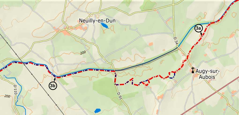
165 165
166 Variant via Augy Km 53.2 Follow the D28, direction Ainay-le-Château. [4] Km 56.0 Arriving at Ainay-le-Château (HVFW services), continue straight on, via the Rue de l'orange. Km 56.5 Place du Faubourg. << To reach the hostel (250m), turn left here and in the bend, continue straight on, via the D64. >> Turn right through the town gate. You are back on the main route 1.2 at point Km 72.3 (see page 38). Shorter route from the bridge of Vernais directly to Charenton-du-Cher. Km 50.0 At the bridge of Vernais, do not cross or turn, but continue along the towpath. Km 51.0 Pass a small bridge cross the canal (a pond on your left). Km 53.0 Pass a small bridge across the canal. Km 54.8 Laugère (B). First pass a small bridge, then cross the D953. Km 56.2 Pass a small bridge. Km 57.2 Bridge of the D41E. Turn left onto the D41E, which further on becomes Rue du Stade. Km 57.7 Charenton-du-Cher. Turn right onto Rue Nationale. After 200m, on the Place de l'église, continue straight ahead. You are now back on the main route 1.2. To pass on your remarks etc., see 166

167 167
168 Variant via Bergerac Route via Bergerac 3.4a - Périgeux > Les Trois Frères: 27,5 km Km 59.5 Périgueux. With your back towards the Cathedral [1], turn right and descend the stairs of Rue de Tourville. Cross the boulevard Saumade, turn right and descend to the quays. Follow the Voie Verte Berges de l'isle. Pass under the bridge Saint Georges, continue straight on via Rue Nouvelle des Quais. Cross the river at the small bridge Japhet and continue along the road with the same name. After 100m bear right on to Chemin de La Fontaine des Malades. Km 60.5 Follow the roundabout near the railway bridge on the right side and continue straight on via Chemin de la Maladrerie, beside a former pilgrims' hospital. Turn right and continue along the river. Near a small ferry (at a former ford), follow the asphalt road to the left. Km 62.5 km Near a transformer, turn left on to a path through the forest. Keep climbing on the rightmost path. Back on asphalt, continue straight on. Turn right on to a dirt road and then follow a path through the forest around the Chateau de Beaufort. After 1 km through forest and undergrowth, turn right onto the D113, up. Km 65.0 Coulounieix. (W) Before the church, follow the roundabout on the left side (bar, bakery). Turn left on to Rue des Eglantiers and descend. After 1.5 km, cross the highway and continue beside a power plant. Immediately after, turn left, on to a half-paved road, up, at first parallel to the road you just left. Km 67.0 km At a hamlet, turn left on to a half paved road, which turns into a paved road. After 700 meters turn left on to a dirt road. You climb to a forest clearing. Km 69.5 T-junction. Turn right, pass an estate. Go a quarter turn to the right, on to a grassy path which becomes stony afterwards and runs along a forest. Descend to a beautiful valley. At a crossing, turn right, direction Km 71.5 La Vigerie. Cross the hamlet via an asphalt road and arrive at the hamlet of Mérigounaud. The road becomes a wide half-paved path, which you follow for 1.3 km, to arrive at an asphalt road. Turn left and then right at a junction, on to a deep grassy path on the left side of the asphalt road. Descend and at a junction turn sharply to the left. The path has become narrow and runs through dense undergrowth of brambles amongst others [2a]. 168


169 169
170 Variant via Bergerac Km 73.9 Turn sharply left [2a] to climb to the hamlet of Biternat. Cross the hamlet, turn right at the crossing and continue straight on at the next crossing. Km 75.5 Chalagnac. Pass the church on the left and then go left and right, between the houses. The path descends and follows a valley with undergrowth. Near a house, the path becomes a dirt road. Turn left at the crossing of La Rancie and then immediately right, up, through the forest. After 1.7 km turn right, on to a road. Km 79.0 Cross the road and continue straight via the asphalt road for 1.3 km and cross the road from Les Bourboux/les Clèdes. Cross a plateau and the walk through a forest. The road descends to the D43. Cross the D43 and continue, to arrive at the village of: Km 82.5 Grun (A) Turn right in the village, climb 150 meters and turn left on to a path through undergrowth. Turn to the right at a road and continue straight on at a crossing. Descend along the tarmac road, at the bottom take the dirt road to the left [2b], through a forest, to arrive at a Km 85.3 Plantation of fruit trees. Continue along the lake and on the corner turn right on to a long straight road that crosses the entire plantation/fields. After passing another lake, the road curves to the left and then to the right. Pass an abandoned building on the right, the path arrives at a road near a transmitter. Turn left and then left again, on to the D42. Km 87.0 km Les Trois Frères. Camping Orphéo Négro (G T W). 3.5a - Les Trois Fre res> Bergerac: 30,3 km Km 87.0 Les Trois Frères. Rejoin the D42, direction Villamblard. After 1 km, turn left on to the half paved road DFCI ('Défense des Forêts Contre l'incendie '- access road in case of fire). After 400 meters turn left, direction l'abbayot. [3] 170

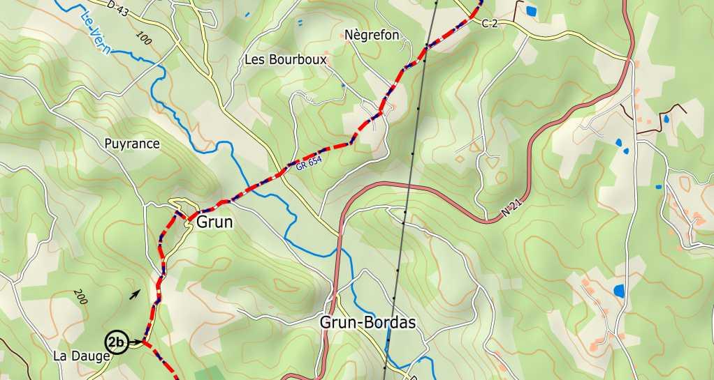

171 171
172 Variant via Bergerac Km 87.3 Direction l'abbayot [3]. At the end of the hamlet, turn right and take the half-paved road to a Km 90.0 Crossing. Continue straight ahead on the asphalt road until the end of the village: Km 92.0 Douville. At the crossing with the D39, turn left. At the next crossing turn right, direction: Km 94.1 Pont Saint Mamet (B I W). Follow the paved road (D38) which crosses the village. At a crossing, turn right on to the road to Montagnac La Crempse. After 400 meters, turn left on to a half-paved road, up. Cross the hamlet of La Devinie and continue along the half-paved road to the hamlet of Le Pinier. At the T-junction, take the road to the right, down towards a tarmac road. Turn left and after 400 meters turn right, up, direction Km 97.0 Le Tournier. Keep following the road and arrive at the hamlet of Plait à Dieu, keep following the road, then turn right on an asphalt road and after 50 meters turn to the left (DFCI) and arrive at the hamlet of: Km Le Sorbier. At the crossing: continue straight on. At the hamlet of Le Mas de la Pin [4]: straight on again. 172


173 173
174 Variant via Bergerac Km Le Mas de la Pin [4]: continue straight on. Then leave the paved road, to descend, to the right via a grassy path towards Km Campsegret (B W). Turn right at the church and then turn left at the first crossing. Walk along the lake of Beau Soleil and at the crossing go straight on. After 200 meters, near allotments, turn left on to a grassy path. Cross a road, then resume the path, that climbs towards Parouty. Pass between two barns, keeping to the left, and arrive at a small road. Turn right and cross the hamlet, up. At a crossing, turn left into an asphalt road that descends to the village of: Km Queyssac. Continue walking, between the church and the market hall, and follow the road passing the cemetery on the left, out of the village. After climbing 800 meters there is a second cemetery on the right. After 100 meters, turn left onto the asphalt road Chemin de la Ribeyrie. After 700 meters, at a crossing, turn right on the asphalt road Chemin des Greloux. After another 700m, just before a curve to the left (the road ends soon after), turn sharply right, on to a forest path. You arrive at vineyards. Follow the grassy path, a forest to the left and the vines to the right. Before the path curves to the right, take the second forest path to the left and descend through the forest. You arrive again at vineyards. Go right, through the vineyards. At the small road of the castle of Le Renaudie (crucifix) you descend to the left, towards the N21. Follow this by the roadside in order to arrive at the village of Km Lembras (H W). Pass in front of the stadium and climb towards the town hall (Mairie). At the junction, turn left and follow this road until the end. Then turn left and descend to the roundabout of Pombonne. Before the roundabout, turn right and arrive in the Km city park. Turn left and follow the road that winds through the park. After 1500 meters [5a]. 174


175 175
176 Variant via Bergerac Km Park [5a]. After 500 meters: turn on to "Route de Brunetière', turn left and then take Rue Montesquieu and Rue Saint Martin. Walk along the Gambetta square and at the end turn left. Km Bergerac (H A W R) Church of Notre Dame. Opposite the church, continue along the Grand Rue (pedestrian area) for 300 meters and arrive at the Church of Saint James (Saint Jacques). 3.6a - Bergerac > Sainte-Foy-la-Grande: 31 km Km Bergerac. From the Church of Saint James, leave the square of Pélissière, to arrive at the Dordogne river. Then continue in the direction of the old bridge. Cross it and turn right between houses on to Rue Barbacanne. Then follow the quay of la Pelouse, and Rue J.J. Rousseau. Walk along the river to Rue J. Martheille. Turn left into that street. Km Roundabout. [5b] Continue straight on, via Route de St Laurent des Vignes, which leads to a bypass. Cross the bypass (watch out, dangerous). At the fountain of Gabanelle (former pilgrims' hospital), turn right. After 200 meters and then turn right again. Follow this road for 700 meters and at the junction continue straight on. Near a house you bend to the left, on to the path that arrives at the road. Km Turn left, into the vineyards. At a junction between the vineyards, turn left. Continue again towards the D 14. Cross this road, and follow it to the right for 100 meters, along vineyards, then turn left towards the castle of Km Le Faget. Cross the road and continue straight on, via the overgrown path that descends towards the chapel Saint Mayme. Pass in front of the chapel. [6a] 176


177 177
178 Variant via Bergerac Km Along the chapel [6a] and keep following the road. At the first crossing, turn left, and continue for 1 km. Then turn left, and after 150 meters turn right. Follow this road to arrive at the hamlet of Gamarde. Cross the road and continue straight on, up. Pass in front of the house and keep following the road, up. At the top, turn right. At the corner of a vineyard, descend, and at the crossing, continue straight on, up, between the vineyards. Arrive at a road and turn right, direction: Km Malveyrin (Community of Pomport). [(A) in Pomport] In this hamlet, turn left, then turn right at the crossing. Near the crucifix, go left, direction Larchére and continue along the hill (Tertre) of Larchére. The road turns into a path that descends and then follows a stream. At the end of the path (muddy), turn left and cross the bridge. This road leads to the D15. [6b] Turn right and after a few dozen meters turn left again, on to the path at the corner of a house. Km Follow this road for 600 meters and then turn right, on to a path that crosses a small stream and then climbs to reach a small road. Turn right direction: Km Gageac-Rouillac. Continue straight on, pass in front of the castle and after 100 meters, turn left, continue between the houses and arrive at a path, that descends first and then climbs up to the village of Km Saussignac (G). At the «Stop», turn left. Pass in front of the church and then turn right on to the first street. Follow this road for one kilometer. In a bend, continue straight on [6c] on to a road that descends first and then climbs towards a plateau, to arrive at a road which you follow to the right, to arrive at the village of Km Razac-de-Saussignac. Cross the village, keep left at the crossing and arrive at the D18. Turn right and after 300 meters, turn left. Before the hamlet of Petit Fonsalade, in a bend, turn to the right on to the road of Grand Fonsalade. Pass in front of the farm (beware, unfriendly owners). Km Continue straight on. Turn right at a road and after 300 meters, turn left, passing in front of a house. [7] 178


179 179
180 Variant via Bergerac Km Pass beside a house [7], then follow the path through the vineyards. At the T junction, turn right, up, and then to the left, walking along a forest. At the end of it you turn onto a small road that descends towards a crucifix. Get back on the road in the curve, descend again, to the church of Km Pineuilh. Follow Rue de L'Eglise, go straight ahead at the roundabout, turn left opposite the bus stop. Km Sainte-Foy-la-Grande (I H B T W R) church. Continue on page 108. To pass on your remarks etc., see 180

181 181


182 Elevation profiles Section 1.1 Vézelay Nevers, 105,0 km Section 1.2 Nevers Saint-Amand-Montrond, 91,5 km Section 1.3 Saint Amand-Montrond Gargilesse, 101,6 km Section 1.4 Gargilesse Crozant, 18,8 km 182


183 Section Crozant Saint Leonard de Noblat, 94,9 km Section Saint Leonard de Noblat La Coquille, 80,2 km Section La Coquille Périgueux, 59,5 km Section Périgueux Port-Sainte-Foy/Sainte-Foy-la-Grande, 82,4 km 183


184 Section 4: Sainte-Foy-la-Grande Captieux, 101,1 km Section 5: Captieux Sault-de-Navailles, 112,0 km Section 6: Sault-de-Navailles Saint-Jean-Pied-de-Port, 84,3 km Variant Augy: Nevers Ainay-le-Château, 56,5 km Variant via Bergerac: Périgueux Sainte-Foy-la-Grande, 88,8 km 184
Amis et Pèlerins de Saint-Jacques de la Voie de Vézelay
 Amis et Pèlerins de Saint-Jacques de la Voie de Vézelay Siège social : 24 rue Saint-Pierre Chemins de Saint-Jacques de Compostelle en France (1998) 89450 - Vézelay Basilique et colline de Vézelay (1979)
Amis et Pèlerins de Saint-Jacques de la Voie de Vézelay
 Amis et Pèlerins de Saint-Jacques de la Voie de Vézelay Siège social : 24 rue Saint-Pierre Chemins de Saint-Jacques de Compostelle en France (1998) 89450 - Vézelay Basilique et colline de Vézelay (1979)
the vezelay route via lemovicensis to St.Jean-Pied-de-Port Update of Southern variant via Nevers version January 2016
 the vezelay route via lemovicensis to St.Jean-Pied-de-Port Update of Southern variant via Nevers version January 2016 Date update: January 1, 2017 Changes in the directions Section 1.1 Km 3.6 Leave the
the vezelay route via lemovicensis to St.Jean-Pied-de-Port Update of Northern variant via Bourges version January 2017
 the vezelay route via lemovicensis to St.Jean-Pied-de-Port Update of Northern variant via Bourges version January 2017 Date update: August 15, 2017 Changes in the directions Section 1.1 Addition with variant
the vezelay route via lemovicensis to St.Jean-Pied-de-Port Update of Southern variant via Nevers version January 2017
 the vezelay route via lemovicensis to St.Jean-Pied-de-Port Update of Southern variant via Nevers version January 2017 Date update: August 15, 2017 Changes in the directions Section 1.1 Km 22.5 Vignes-le-Haut
the vezelay route via lemovicensis to St.Jean-Pied-de-Port Update of Southern variant via Nevers version January 2016
 the vezelay route via lemovicensis to St.Jean-Pied-de-Port Update of Southern variant via Nevers version January 2016 Date update: January 1, 2018 Changes in the directions Section 1.1 Km 3.6 Leave the
Amis et Pèlerins de Saint-Jacques de la Voie de Vézelay
 Amis et Pèlerins de Saint-Jacques de la Voie de Vézelay Siège social : 24 rue Saint-Pierre Chemins de Saint-Jacques de Compostelle en France (1998) 89450 - Vézelay Basilique et colline de Vézelay (1979)
Amis et Pèlerins de Saint-Jacques de la Voie de Vézelay
 Amis et Pèlerins de Saint-Jacques de la Voie de Vézelay Siège social : 24 rue Saint-Pierre Chemins de Saint-Jacques de Compostelle en France (1998) 89450 - Vézelay Basilique et colline de Vézelay (1979)
The Vezelay Route. Via lemovicensis. to St.Jean-Pied-de-Port. Southern variant via Nevers
 The Vezelay Route Via lemovicensis to St.Jean-Pied-de-Port Southern variant via Nevers Overview of facilities along the route Edition: January 1, 2018 To be used in conjunction with the guide of the same
The Vezelay Route. Via lemovicensis. to St.Jean-Pied-de-Port. Southern variant via Nevers
 The Vezelay Route Via lemovicensis to St.Jean-Pied-de-Port Southern variant via Nevers Overview of facilities along the route Edition: March 7, 2018 To be used in conjunction with the guide of the same
The Vezelay Route. Via lemovicensis. to St.Jean-Pied-de-Port. Southern variant via Nevers
 The Vezelay Route Via lemovicensis to St.Jean-Pied-de-Port Southern variant via Nevers Overview of facilities along the route Edition: June 6, 2018 To be used in conjunction with the guide of the same
THE GUIDE INFORMATION & ENVIRONMENT
 THE GUIDE INFORMATION & ENVIRONMENT Michel GODARD Directeur du CREPS IDF The REGIONAL CENTER FOR PHYSICAL EDUCATION is a French public sport institution, under the supervision of the Sports Ministry and
The Coastal Way - Landes
 The Coastal Way - Landes Secondary road of the roads of Santiago de Compostela, coming from Soulac in the Gironde, it enters the Landes in Sanguinet and for nearly 150 km it follows the Atlantic coast
Paris Walking Tour Information Tour Descriptions and Highlights. Paris Walking Tours Fact Sheet
 Paris Classic Walks Welcome to the "City of Lights" and to everything Paris has to offer. Our classic walks were designed with the English-speaking traveller in mind and are ready to show you Paris as
Top 50 Tourist Attractions
 PARIS Top 50 Tourist Attractions Musée du Louvre The Louvre Museum was originally a 12th century fortress for Phillip II, and when Louis XIV finally left it for the Palace of Versailles it had various
Easy to get to, difficult to leave. We hope this document helps you to get here the leaving is up to you.
 How to get to us. Easy to get to, difficult to leave. We hope this document helps you to get here the leaving is up to you. Within this document you will find the following information: A list of local
52
 51 52 53 54 55 56 57 58 59 60 61 62 63 64 65 66 67 68 Zone 21 - Technical description Given the complexity of Zone 21, a techical description of its boundaries follows: It should be noted that hunting
Difficult Run Stream Valley Park
 Difficult Run Stream Valley Park The more intense mountain bikers have known about for Difficult Run for some time. Equestrians have known it longer. Eight miles of unpaved trail, the Rails to River Trail
The Vezelay Route. Via lemovicensis. to St.Jean-Pied-de-Port. Northern variant via Bourges
 The Vezelay Route Via lemovicensis to St.Jean-Pied-de-Port Northern variant via Bourges Overview of facilities along the route Edition: January 1, 2018 To be used in conjunction with the guide of the same
Hindhead, Keffolds Copse and Gibbet Hill
 point your feet on a new path, Keffolds Copse and Gibbet Hill Distance: 6 km=4 miles Region: Surrey Author: Schwebefuss Refreshments: Punch Bowl Café moderate walking Date written: 14-apr-2015 Last update:
Les Cerisiers. Les Noisettes. La maison d'à coté.
 Les Cerisiers http://leroannais.com/noesit/!/fiche/515473 In a beautiful area on the borders of Beaujolais and the Saône-et-Loire stone house on a property including the House of the owners and 3 guest
City Orientation Walk
 Copyright by GPSmyCity.com - Page 1 - City Orientation Walk Annecy is a charming town with rich history that is reflected in its magnificent buildings, streets, bridges, gates and parks. There is a fascinating
0 mi Head northeast 0.06 mi Turn right 0.08 mi Turn left 1.58 mi Head west on Bd du Général de Gaulle/D925 toward Rue Irénée Bourgois Continue to
 0 mi Head northeast 0.06 mi Turn right 0.08 mi Turn left 1.58 mi Head west on Bd du Général de Gaulle/D925 toward Rue Irénée Bourgois Continue to follow D925 1.76 mi Slight right onto Rue Claude Groulard/Pl.
The Loire Valley by bike 1st stage: From Nevers to Orleans - France
 S-CAPE TRAVEL - EMAIL: INFO@S-CAPETRAVEL.EU - TELEPHONE +34 985846455 - WWW.S-CAPETRAVEL.EU style : level : duration : comfort : period: code: E-BIKES CYCLING Selfguided 7 days Apr May Jun Jul Aug Sep
the Randle Activity Barge Cruise Burgundy Canal du Nivernais Canal & River Cruise
 the Randle Activity Barge Cruise Burgundy Canal du Nivernais Canal & River Cruise Evening dining: Hostellerie de le Poste, the towns oldstaging inn where the post would have been delivered by horse and
Freefolk and Whitchurch
 Trail Activity Type Terrain Author Distance Ascent Location : HAMPTR0026 : Walk : Tea Shop : Towpaths and Cycle Tracks : Jean Patefield : 5.6 miles / 9 kms : 377 feet / 115 metres : SU487488 / RG28 7NN
A Circular Walk from Chapel Carn Brea
 A Circular Walk from Chapel Carn Brea 4.3 Miles A Walk Visiting Five Historic Ancient Sites This circular walk offers the possibility of several alternatives, depending on the walker s available time and
PRE CONGRESS TOUR. Pre tour Programme:
 76 th IIRB CONGRESS 2018 DEAUVILLE (NORMANDY) PRE CONGRESS TOUR 4 days: Friday1 st June to Monday 4 th June 2018. Minimum 20, maximum 45 participants. The registered participants are invited to meet and
The Rocher du Long Boyau and the Gorges du Houx
 A walk proposed by Netra From the Ermitage de Franchard, this is a very varied hike which will take you past old sandstone quarries, the Gorges du Houx and the charming Mare aux Pigeons. On the route are
Route 5: The Athlete s Itinerary
 5 ~ 8 déc 2014 lyo n fetedeslumieres.lyon.fr Route 5: The Athlete s Itinerary Brakes? OK! Bike lights? OK! Helmet? OK! Padlock? OK! And you re off. Hop on your bike, put on your skates and get ready for
the Randle Burgundy Barge Cruise Burgundy Canal du Nivernais Canal & River Cruise
 the Randle Burgundy Barge Cruise Burgundy Canal du Nivernais Canal & River Cruise Monday We depart at 9am and descend the lock onto the river Yonne and then onto the Nivernais canal, the morning cruise
Placement Offer Form
 Placement Offer Form A compléter en anglais et à renvoyer au plus tard le 15/04/14 à l adresse suivante (avec la mention «offre de stage secteur scolaire»): erasup@2e2f.fr SCHOOL INFORMATION Name of organization
Stage 2: Following the royal cattle route towards the medieval castle of the Mendozas. Tres Cantos to Manzanares el Real
 Stage 2: Following the royal cattle route towards the medieval castle of the Mendozas. Tres Cantos to Manzanares el Real 25,1 km, 6,5 hrs, é513m, ê344m, ñ661-1008m 0,0 km ñ745m Tres Cantos tvsäã 0,9 km
The Mendip Way. Route Directions and Maps Uphill to Wells
 The Mendip Way Route Directions and Maps Uphill to Wells Website: www.mendiphillsaonb.org.uk Email: mendip@mendiphillsaonb.org.uk Facebook & Twitter: @MendipHillsAONB Phone: 01761462338 1 Uphill to Loxton
Versailles Tours Descriptions and Highlights Multiple tour options available. Versailles Tours Fact Sheet
 Paris Versailles Tours After a short journey to Versailles, avoid the tremendously long lines by booking one of these tours. See the room where Marie Antoinette's guards were killed as they protected her
Grand Prix Cycliste de Québec
 Grand Prix Cycliste de Québec A- Côte de la Montagne (42m) B- Côte de la Potasse / Rue des Glacis (47m) C- Côte de la Fabrique / Rue des Jardins (47m) D- Rue Saint-Louis / Grande Allée (91m) See https://www.youtube.com/watch?v=nphpkblfypw
TAB 1. Impacts of Religious Tourism Lourdes
 Impacts of Religious Tourism Lourdes Sections: 1. Why is Lourdes so appealing to its visitors? 2. How are visitor trends changing? 3. What are the impacts of tourism on Lourdes? 4. Activities 5. Evidence
Auxonne. Capital of the Val de Saône. Côte-d Or. City walking tour. Burgundy
 Auxonne Capital of the Val de Saône Côte-d Or City walking tour Burgundy Start : Tourist Information Center 1 5 rue de Berbis : Former Berbis s mansion. 17 th century front in pink stone from Moissey (quarry
Bewl Water & the High Weald
 1 Bewl Water & the High Weald Stonegate station - Stonegate - Wallcrouch - Newbarn - Cousley Wood - Wood's Green - Wadhurst station Length: 9 ½ miles (15.3km) Underfoot: Large portions of this path are
Sponsored by. statestreet.com
 /STATESTREETISLANDWALK #ISLANDWALKJSY Sponsored by statestreet.com Important Information If you forget everything else PLEASE remember the following.» Remember to check OUT of every checkpoint» If you
WORKCAMP 1 - Landscaping and natural heritage Where: FARGUES-SAINT-HILAIRE When: 04/05-19/
 WORKCAMP 1 - Landscaping and natural heritage Where: FARGUES-SAINT-HILAIRE When: 04/05-19/05 18 + Concordia and UFCV have been partners for many years. UFCV s leisure center is located in the beautiful
La Grande Cascade (Grand s falls)
") La Grande Cascade (Grand s falls) 1 2 Name: Grande Cascade (Grand s falls) Town : Le Mont Dore Owner: council et private References : Longitude : 2 49 12.4"E Latitude : 45 33 57.6"N Access: by car and
La Grande Cascade (Grand s falls) 1 2 Name: Grande Cascade (Grand s falls) Town : Le Mont Dore Owner: council et private References : Longitude : 2 49 12.4"E Latitude : 45 33 57.6"N Access: by car and
RAMBOUILLET MY CITY AND MY SCHOOL
 RAMBOUILLET MY CITY AND MY SCHOOL Brugnacchi Anna Barbini Marie Collège le Racinay Faucon Charlène 4ème 1 et 2 Lecrop Tiphanie Année 2009-2010 05/04/2010 1 I Introduction 1 ) Presentation Hello! We are
Pontfadog. Walk A. Walk A
 Walk A A Bird s eye view of the village 2km. (1 1 /2 miles); height gain 45m. (150ft) about 45 minutes. Six minutes walk along the main road towards Glyn Ceiriog reach a signpost to Llwynmawr. Take the
Mont Saint-Michel And Chartres By Henry Adams
 Mont Saint-Michel And Chartres By Henry Adams If searched for a book Mont Saint-Michel and Chartres by Henry Adams in pdf format, then you have come on to correct site. We furnish utter variant of this
The slopes of the Citadel. A path along terraces
 The slopes of the Citadel A path along terraces Linking rue Pierreuse to the top of the Montagne-de-Bueren staircase, this area has several viewpoints over the city and vast grassy terraces. You will see
Dinner in town of St Jerome. I ve marked a few places on the map. Breakfast at the hotel
 Day 1 Arrive in Saint-Jerome by car Best Western Hotel St. Jerome 420 Monseigneur-Dubois Boulevard Saint-Jerome, Quebec J7Y 3L8, Canada Phone: 450-438-1155 info@bwlaurentides.com Dinner in town of St Jerome.
FRANCE & SWITZERLAND PARIS, LYON, CHAMONIX AND GENEVA. 10 days / 8 nights - March 17-26, (Travel dates to be confirmed upon flight booking)
") FRANCE & SWITZERLAND PARIS, LYON, CHAMONIX AND GENEVA 10 days / 8 nights - March 17-26, 2017 (Travel dates to be confirmed upon flight booking) DAY 1: USA / FRANCE (Friday) Fly through the night to Paris,
FRANCE & SWITZERLAND PARIS, LYON, CHAMONIX AND GENEVA 10 days / 8 nights - March 17-26, 2017 (Travel dates to be confirmed upon flight booking) DAY 1: USA / FRANCE (Friday) Fly through the night to Paris,
Agent (France.com) Day Paris Budget Package $ USD PER PERSON
 Day Paris Budget Package $ USD PER PERSON") Agent (France.com) 1 800 230 0426 http://www.france.com reservations@france.com 7-Day Paris Budget Package $749.00 USD PER PERSON Page 2 of 12 TRIP SUMMARY Day 1 Arrival and transfer - Charles De Gaulle
Agent (France.com) 1 800 230 0426 http://www.france.com reservations@france.com 7-Day Paris Budget Package $749.00 USD PER PERSON Page 2 of 12 TRIP SUMMARY Day 1 Arrival and transfer - Charles De Gaulle
Hay Wood, Rowington and Baddesley Clinton - Warwickshire
 Hay Wood, Rowington and Baddesley Clinton - Warwickshire Starts at Lay-by alongside Hay Wood 2 hours 30 minutes 5.5miles 8.8km Leisurely ID: 0.683 Developed by: John Clift Checked by: Andy Page www.ramblersroutes.org
Religious Sites in Carcassonne
 Copyright by GPSmyCity.com - Page 1 - Religious Sites in Carcassonne Carcassonne is remarkable for its impressive churches and cathedrals. The majority of them were built in Gothic Languedoc style and
San Miguel to Caserio de la Hoya Circular (San Miguel)
") Tenerife Sur: Short Walks Under 10 km San Miguel to Caserio de la Hoya Circular (San Miguel) Route Summary An informative and scenic walk back in time from San Miguel to below El Roque, overlooking the
Tenerife Sur: Short Walks Under 10 km San Miguel to Caserio de la Hoya Circular (San Miguel) Route Summary An informative and scenic walk back in time from San Miguel to below El Roque, overlooking the
Québec. Table of Contents Regulations and other Acts Index
 Gazette officielle DU Québec Part 2 No. 10A 10 March 2016 Laws and Regulations Volume 148 Summary Table of Contents Regulations and other Acts Index Legal deposit 1st Quarter 1968 Bibliothèque nationale
TOUR: 7 DAYS 6 NIGHTS SCHENGEN EUROPE ROUTE: PARIS-BRUSSELS-AMSTERDAM-COLOGNE-FRANKFURT-BLACK FOREST-RHINE FALLS- ZURICH Tour Code: GP76SCHERP
 TOUR: 7 DAYS 6 NIGHTS SCHENGEN EUROPE ROUTE: PARIS-BRUSSELS-AMSTERDAM-COLOGNE-FRANKFURT-BLACK FOREST-RHINE FALLS- ZURICH Tour Code: GP76SCHERP (Valid Till : 28 Feb 2019) All Rates quoted in Euro, Per person
 Routes around Solsona The surroundings of Solsona, called el Vinyet, preserve an old mosaic of forests, fields, farmhouses and stone walls. The group of suggested routes has a low level of difficulty and
Contact :
 Organize by French s RENAULT 25 Club httttp::////www..renaulltt25..com Club Renault 25 Français Chez Mr Zickgraf 3 Avenue Jean Villejean 45500 Gien France Contact : renault25@tronic.fr The president s
GRINDLEFORD GALLOP 2018
 GRINDLEFORD GALLOP 2018 Route Information The Grindleford Gallop follows a fixed 21 mile route through the lanes and paths of Derbyshire. All competitors must follow this route. An OS map of the area with
HARDMOORS 55 RACE ROUTE 2018 HELMSLEY - GUISBOROUGH
 HARDMOORS 55 RACE ROUTE 2018 HELMSLEY - GUISBOROUGH HELMSLEY - CHECKPOINT 1 (WHITE HORSE) 1. Leave RACE START, continue ahead on road (Baxtons Sprunt) At crossroads turn right down Canons Garth eventualy
Ardingly Lake, Ouse Valley, Borde Hill
 point your feet on a new path Ardingly Lake, Ouse Valley, Borde Hill Distance: 14 km=9 miles or 12½ km=8 miles Region: West Sussex Author: Hautboy Refreshments: Borde Hill Map: Explorer 135 (Ashdown Forest)
Welcome Guide Les Arcs Self Catered
 Welcome Guide Les Arcs Self Catered LES ARCS 1800 Where to Collect your Keys There are two key agencies handling apartments in Les Arcs 1800 please see your final details email for information on which
Paris, Champagne & The French Countryside
 Agent (France.com) 1 800 230 0426 http://www.france.com reservations@france.com Paris, Champagne & The French Countryside $2,029.00 USD/ per person Page 2 of 11 TRIP SUMMARY Day 1 PARIS - Paris Check in
Walk 1. Cotswold Water Park. Gateway Centre to Cerney Wick, railway track to Lake 6, Gateway Centre.
 Cotswold Water ark Walk way A Swindon/ Cirencester Thomas and Severn Canal way to Cerney Wick, railway track to Lake, way. Spine Road East Hotel Time: hours (short walk km) Distance: km A level walk along
Religious Walking Tour in Rennes
 Copyright by GPSmyCity.com - Page 1 - Religious Walking Tour in Rennes Rennes is a city rich with religious heritage and has plenty to offer for the religious oriented traveler. Among the most important
PARIS THE 13TH TH 18TH OF MAY This time the trip went to Paris.
 PARIS THE 13TH TH 18TH OF MAY 2010 This time the trip went to Paris. Paris is an European metropolos and the capital of France. The city lies at the river Seine north in France, in the heart of the region
Markets in Dordogne, Gironde and Lot-et-Garonne - Perigueux Hotels: Find 5 Hotel Deals near
 Bordeaux/Perigueux Markets in Dordogne, Gironde and Lot-et-Garonne - - Perigueux: mornings at Place du Coderc, Place de la Clautre, Bordeaux: mornings at Victor Hugo, Place de la Ferme de Richemont - general
3.1 Bowness-on-Solway to Carlisle
 3.1 Bowness-on-Solway to Carlisle Map panel 1 Distance 15 miles (24 km) Terrain minor roads, tracks, field paths and riverside footpath, muddy in places Grade easy, with gentle gradients on undulating
The Great Discover Geneva Treasure Hunt
 The Great Discover Geneva Treasure Hunt COPYRIGHT Family Storr Family Storr provides no express or implied warranties of any kind, including but not limited to those of merchantability, fitness for a particular
Synthèse de l Etude de Faisabilité
 Synthèse de l Etude de Faisabilité Braille & Culture > Association, acknowledged of public interest Created in 1990 Professionalized in 2000 Assented as a solidarity firm in 2009 Staff: Six employees among
CLUB DES CYCLOTOURISTES DIEPPOIS (CDCD)
") Sunday 26 June 2016 CLUB DES CYCLOTOURISTES DIEPPOIS (CDCD) RANDONNEE DES 3 VALLEES 30 KM - Start & finish : SALLE PAUL ELUARD - rue Thiers à DIEPPE Lunch control : Parc Guy Weber à SAINT AUBIN LE CAUF
Sunday 26 June 2016 CLUB DES CYCLOTOURISTES DIEPPOIS (CDCD) RANDONNEE DES 3 VALLEES 30 KM - Start & finish : SALLE PAUL ELUARD - rue Thiers à DIEPPE Lunch control : Parc Guy Weber à SAINT AUBIN LE CAUF
Tours For Women FRANCE The Original Tour
 Tours For Women FRANCE The Original Tour penny.king@toursforwomen.com.au www.toursforwomen.com.au PH: 0433255472 PARIS TO THE COTE D AZUR - AND BACK. This very special 21 day tour has been developed in
ONE RELAX WEEK Take time to discover
 ONE RELAX WEEK Take time to discover For those who want to discover the Brionnais countryside with a donkey but with the possibilities to make some breaks, we suggest you this relax week of hikes. You
Walking tour along the river Bièvre
 Walking tour along the river Bièvre Duration: 2 hours Difficulty: Easy Arrondissements: 13 th and 5 th Length: 5,8 km Here is the first walking tour of Walking in Paris! It will take you along the Bièvre,
Campo: CHELLES (CONCF ) País: Francia Proyecto: Construction (CONS) Edad: Fechas: 08/07/15-29/07/15 Plazas Totales: 2 Plazas Libres: 2
 País: Francia Proyecto: Construction (CONS) Edad: Fechas: 08/07/15-29/07/15 Plazas Totales: 2 Plazas Libres: 2") Campo: CHELLES (CONCF-091-15) Proyecto: Construction (CONS) Fechas: 08/07/15-29/07/15 Plazas Totales: 2 Plazas Libres: 2 Project: The city of Chelles disposes of an ideal geographic location: less than
Campo: CHELLES (CONCF-091-15) Proyecto: Construction (CONS) Fechas: 08/07/15-29/07/15 Plazas Totales: 2 Plazas Libres: 2 Project: The city of Chelles disposes of an ideal geographic location: less than
France. Educational Tour. Nice - Monaco - Menton - Cannes - Marseille Les Beaux de Provence - Avignon Paris. 11 Days / 9 Nights
 France Educational Tour Nice - Monaco - Menton - Cannes - Marseille Les Beaux de Provence - Avignon Paris 11 Days / 9 Nights March 9th to March 19th, 2018 $3,352.00 CAD per person YOUR EDUCATIONAL TOUR
APPENDIX 1 PROFILE OF THE BATTLEFIELDS PARK SITES MANAGED BY THE NATIONAL BATTLEFIELDS COMMISSION. Page 1
 APPENDIX 1 PROFILE OF THE BATTLEFIELDS PARK SITES MANAGED BY THE NATIONAL BATTLEFIELDS COMMISSION Page 1 SITE FOR MAJOR EVENTS A wide open space with natural slope located behind the Discovery Pavilion
History and heritage in Saint-Paul de Vence
 History and heritage in Saint-Paul de Vence Saint-Paul de Vence, city of arts. Yes, but not only! Although readily associated with artists and their works, Saint-Paul de Vence is also a major heritage
Rock Creek Park, MD - Lake Needwood
 ock Creek Park, MD - Lake Needwood Lake Needwood, is a reservoir located at the end of the north end of the ock Creek hiker-biker trail. At the other end, ock Creek empties into the Potomac iver near Thompson
Mont Saint-Michel And Chartres By Henry Adams
 Mont Saint-Michel And Chartres By Henry Adams If looking for the ebook Mont Saint-Michel and Chartres by Henry Adams in pdf format, then you've come to right website. We present the complete edition of
FRANCE PARIS SERA TOUJOURS PARIS 8 DAYS / 6 NIGHTS. June (Dates of travel to be confirmed upon flight booking)
") FRANCE PARIS SERA TOUJOURS PARIS 8 DAYS / 6 NIGHTS June 2018 (Dates of travel to be confirmed upon flight booking) DAY 1: USA - FRANCE Fly overnight to Paris. DAY 2: PARIS Upon arrival, your French Forum
FRANCE PARIS SERA TOUJOURS PARIS 8 DAYS / 6 NIGHTS June 2018 (Dates of travel to be confirmed upon flight booking) DAY 1: USA - FRANCE Fly overnight to Paris. DAY 2: PARIS Upon arrival, your French Forum
France Loire Valley Boat and Bike Tour 2018 Guided Tour 8 days/7 nights
 France Loire Valley Boat and Bike Tour 2018 Guided Tour 8 days/7 nights The area of the Valley of the Loire between the cities of Nevers and Montargis in France is a very suitable region for a relaxing
La Belle France Small Group Short tour. From $5,125 USD. La Belle France Small Group Short Tour. 10 Sep 18 to 20 Sep 18
 From $5,125 USD Single $5,740 USD Twin share $5,125 USD 11 days Duration Europe Destination Level 1 - Introductory to Moderate Activity 10 Sep 18 to 20 Sep 18 La Belle France Small Group Short tour La
From $8,620 USD. Loire Valley walking tours France small group escorted seniors history tour. 25 Jun 18 to 12 Jul 18
 From $8,620 USD Single $9,743 USD Twin share $8,620 USD 18 days Duration Europe Destination Level 4 - Challenging Activity Loire Valley walking tours France small group escorted seniors history tour 25
SUMMER SEASON: FROM APRIL 4TH 2018 TO OCTOBER 31ST 2018
 A selection of fully escorted day and half day tours of Paris and the surrounds All tours include luxury air conditioned coaches with reclining seats, all entrance fees and hotel courtesy pick up service
Directions to Le Chateau de Goult
 1 Directions to Le Chateau de Goult Le Chateau de Goult 84220 Goult France 2 Table of Contents Click title to be taken to location in document Check- in and Check- out Greeter Information Directions Google
This is an Adobe Acrobat file (.pdf) To view it as we intend (as a photo album), click on VIEW then PAGE DISPLAY then TWO-UP
 To view it as we intend (as a photo album), click on VIEW then PAGE DISPLAY then TWO-UP") This is an Adobe Acrobat file (.pdf) To view it as we intend (as a photo album), click on VIEW then PAGE DISPLAY then TWO-UP France 2013 This was our first major trip in our Dreamseeker. The plan had been
This is an Adobe Acrobat file (.pdf) To view it as we intend (as a photo album), click on VIEW then PAGE DISPLAY then TWO-UP France 2013 This was our first major trip in our Dreamseeker. The plan had been
DOWNLOAD OR READ : MONT ST MICHEL AND CHARTRES PDF EBOOK EPUB MOBI
 DOWNLOAD OR READ : MONT ST MICHEL AND CHARTRES PDF EBOOK EPUB MOBI Page 1 Page 2 mont st michel and chartres mont st michel and pdf mont st michel and chartres 2009, all the silt and sand out to sea, far
Mt Kuring-gai Track to Berowra station
 Mt Kuring-gai Track to Berowra station 4 hrs 15 mins 9.7 km One way Hard track 4 553m This walk explores three valleys, with great displays of wild flowers in spring, and some nice sandstone overhangs.
nouvelle-france Tourist circuits to explore Québec City ( > j P
 Tourist circuits to explore Route de la nouvelle-france Route de la Nouvelle-France (New France Route) links Old Québec to the Côte-de-Beaupré and traces the path taken by inhabitants of the Côte-de-Beaupré
Trois-Rivières religious tour
 Trois-Rivières religious tour DISCOVER THE RELIGIOUS HISTORY OF THE SECOND OLDEST CITY OF FRENCH AMERICA 626 N E, T -R DAY, Q, G8T HALF DAY (4 HOURS) OR-DWHOLE (74G9 AND A HALF HOURS) FROM MAY 1ST TO OCTOBER
Grand Saint-Emilionnais Tourist Office. Helpful Guidebook Prepare your trip to Saint-Emilion!
 Grand Saint-Emilionnais Tourist Office Helpful Guidebook Prepare your trip to Saint-Emilion! Saint-Emilion for everyone This guidebook was created in order to collect useful information to prepare your
Road Signs, Markings and Their Meaning
 Road Signs, Markings and Their Meaning FUNCTIONS OF ROAD SIGNS AND MARKINGS 1. Guides 2. Directs 3. Warns 4. Informs 5. Prohibits 6. Regulates CLASSIFICATION OF ROAD SIGNS 1. Warning 2. Regulatory 3. Informatory
FRANCE PARIS, PROVENCE & CÔTE D AZUR. November 17 to 24, DAYS / 6 NIGHTS. (Dates of travel to be confirmed upon flight booking)
") FRANCE PARIS, PROVENCE & CÔTE D AZUR November 17 to 24, 2017 8 DAYS / 6 NIGHTS (Dates of travel to be confirmed upon flight booking) DAY 1: USA - FRANCE Fly overnight to Paris. DAY 2: PARIS On arrival
FRANCE PARIS, PROVENCE & CÔTE D AZUR November 17 to 24, 2017 8 DAYS / 6 NIGHTS (Dates of travel to be confirmed upon flight booking) DAY 1: USA - FRANCE Fly overnight to Paris. DAY 2: PARIS On arrival
Merritts Traverse. 1928m
 Merritts Traverse 3 hrs Hard track 5.8 km Circuit 4 167m This walk starts with a scenic journey to the top of the hill on the chairlift. Starting along Merritts Nature walk, this walk soon detours down
Stage 1: Through the streets of Madrid Madrid to Tres Cantos
 Stage 1: Through the streets of Madrid Madrid to Tres Cantos 24,7 km, 6 hrs, é364m, ê272m, ñ638-762m 0,0 km ñ660m Church of Santiago tvsäã 10,1 km ñ709m Fuencarral tvsäã 19,0 km ñ742m El Goloso tsä 23,8
European Volunteer Team for built Heritage Brittany 2014
 European Volunteer Team for built Heritage Brittany 2014 Summary Presentation of the Heritage team Before the arrival of the European volunteers Welcoming the volunteers The workcamps in Brittany - July
SPINEXPOTM PARIS OFFICIAL EXHIBITORS MANUAL JULY 2018 CITÉ DE LA MODE ET DU DESIGN.
 SPINEXPOTM PARIS OFFICIAL EXHIBITORS MANUAL 2-3-4 JULY 2018 CITÉ DE LA MODE ET DU DESIGN LES DOCKS - 34, QUAI D AUSTERLITZ PARIS 13 FRANCE www.spinexpo.com OFFICIAL EXHIBITORS MANUAL 2-3-4 JULY 2018 -
Plan De Paris Par Arrondissement: Paris Street Guide By District (English And French Edition) Cover Comes In Four Different Colors By Collectif
 Cover Comes In Four Different Colors By Collectif") Plan De Paris Par Arrondissement: Paris Street Guide By District (English And French Edition) Cover Comes In Four Different Colors By Collectif READ ONLINE Books Search Results for Plan de Paris par Arrondissement:
Plan De Paris Par Arrondissement: Paris Street Guide By District (English And French Edition) Cover Comes In Four Different Colors By Collectif READ ONLINE Books Search Results for Plan de Paris par Arrondissement:
The Vezelay Route. Via lemovicensis. to St.Jean-Pied-de-Port. Northern variant via Bourges
 The Vezelay Route Via lemovicensis to St.Jean-Pied-de-Port Northern variant via Bourges Overview of facilities along the route Edition: June 6, 2018 To be used in conjunction with the guide of the same
How the Romans changed Britain By Michael Coleman
 How the Romans changed Britain By Michael Coleman TAX MAN: One of the biggest changes the Romans brought to Britain was peace. The tribes no longer fought each other. And, so long as they didn t rebel,
VILLAGES & VINEYARDS OF PROVENCE SELF GUIDED or GUIDED CYCLE TOUR DAYS/6 NIGHTS
 VILLAGES & VINEYARDS OF PROVENCE SELF GUIDED or GUIDED CYCLE TOUR 2019 7 DAYS/6 NIGHTS The land of light, colours and scents. For these reasons, many well known painters have lived in Provence: Picasso,