La Grande Cascade (Grand s falls)
|
|
|
- Anabel Marshall
- 6 years ago
- Views:
Transcription

 1")
1 La Grande Cascade (Grand s falls) 1

2 2
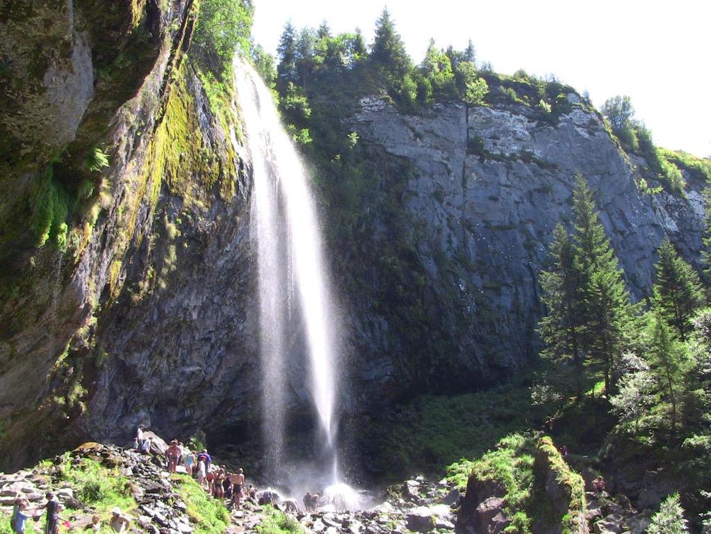
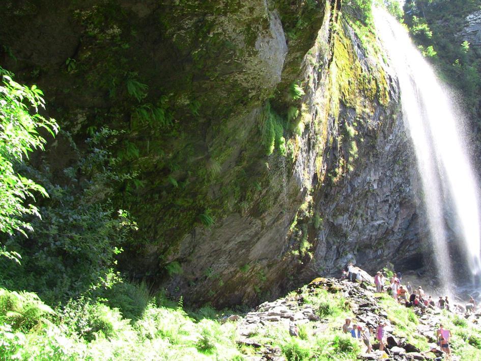
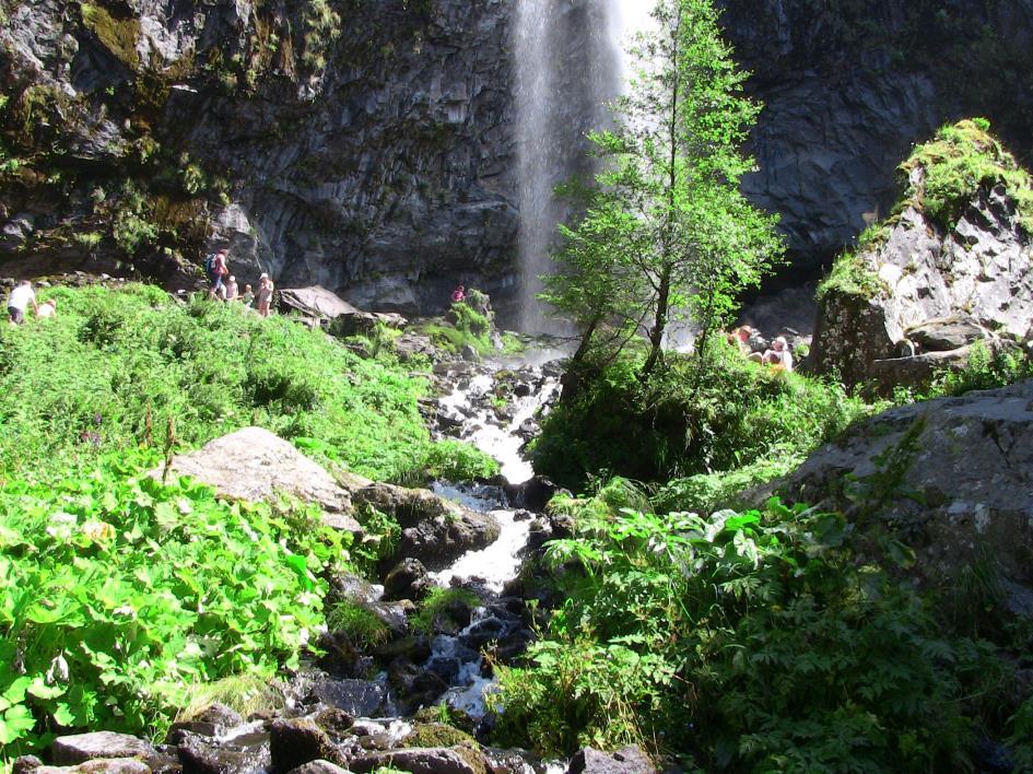
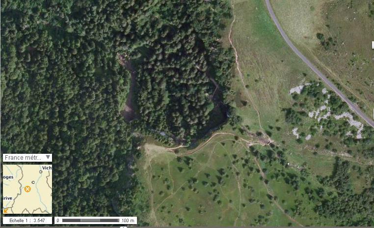
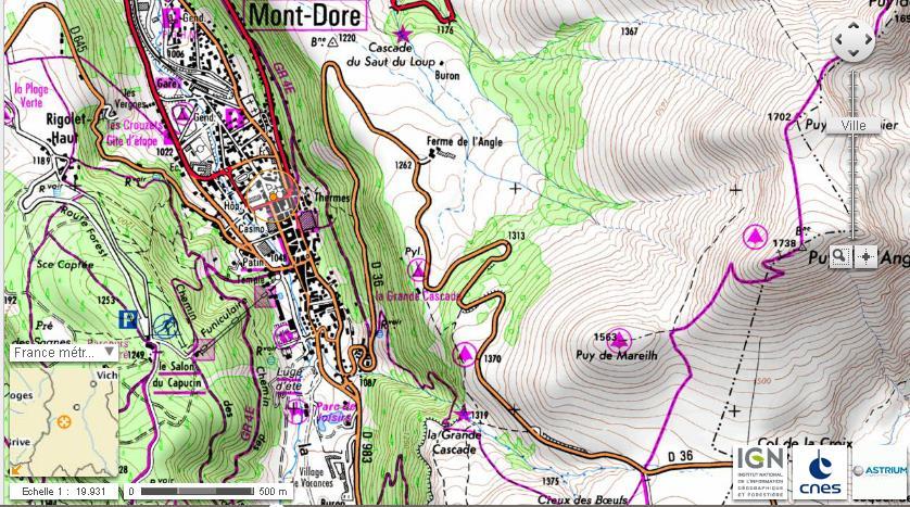
3 Name: Grande Cascade (Grand s falls) Town : Le Mont Dore Owner: council et private References : Longitude : "E Latitude : "N Access: by car and on foot 2 accesses: 1) From Le Mont Dore pump rooms (Les Thermes), take the steps leading up to the signposted short distance hiking path (PR), this path on the right comes out onto the road to Besse, cross over and on the other side a path leads to the waterfall. 2) Take the D36 towards Chambon sur Lac and at Col de la Croix St Robert on the right follow a path for 1.1 km to get to the waterfall via the top. Lenght of itinerary: on foot from Le Mont Dore: 1½ hr / from the D36: 1h30 A/R. Parking: from Col de la Croix St Robert there are 2 car parks 300 m from each other, restaurant at La ferme de l Angle 3 km away. Location of work : option of exhibiting an installation at the foot of the waterfall or on the rock walls and the drop. Description of place: type of soil/ surface area / vegetation / exposure Two paths leave from La Croix de St Robert, one goes towards Puy de l Angle and the other towards Grande Cascade waterfall. The landscape is open and formed of fields under cultivation and pastures for grazing sheep. The footpaths are flanked by fences. This is the vast and lovely plateau de la Durbise. A private tarmacked road, similar to a cart track, starts from this plateau. The vegetation is similar to that of high plateaux and made up of large treeless meadows. To get to the waterfall, the footpath goes down into a "lieu-dit" or place named Les Creux des Bœufs and runs alongside a stream called "Couze Surains". The vegetation near the stream is different and comprises bushes and lots of rowan trees whose red berries add colour to the scenery. The field at the top of the waterfall is used for grazing flocks of sheep. The grass is short and studded with tall tufts of grasses and lavastones. A forest of conifers lines one side of the field and a row of heather and blueberry bushes form its edge. The other side is home to the rowan trees. Its easterly aspect means the sun is present for most of the day in summer. The field covers an area of about 900 m 2. The Grande Cascade site is very popular with visitors. The focus of the visit is a waterfall nearly 100 feet in height dropping over the cliff. Visitors make their way to the viewing point overlooking the valley. These grand falls are a site which is symbolic of the Sancy Massif and more specifically of Mont-Dore. They originate from a spring out on the plateau swept by the Durbise winds at a height of 1450 metres which runs over a series of ancient lava flows. This hundred-foot-high waterfall is one of the highest in the Auvergne. If you look up from the bottom of the falls to the top, you are overwhelmed by a sensation of vertigo. The height and power of the waterfall can also be appreciated from the stairs which lead to the foot of the falls. The viewpoint is very different, but always interesting. Other points of interest: half of the water runs down the rock face, while the other half hurtles out into space, which means that it is possible to get behind the waterfall. At the base of the falls you find yourself surrounded by meadows, surrounded by rock walls with the appearance of cliffs. The lush vegetation (ferns, tall conifers, etc.) contrasts with the blackness of the basalt organ pipes. On hot summer days this location is very busy, and plenty of people take advantage of the falls to cool down. It is a lovely spot for young and not-so-young. Additional information: from the walking track, the view over the town of Mont-Dore is breathtaking. A work located at the top of the falls would be visible from a great distance: from Le Capucin (1468 m), a very popular spot, being the place to aim for from Mt- Dore village and also from the centre of Mt-Dore. Note : In July and August, sheep kept by a shepherd occupy part of the plateau. 3

4 View of Mont Dore 4


5 Car park at Col de la Croix St Robert before going down to Grande Cascade waterfall Footpath going down to Grande Cascade waterfall Sentier en direction de la cascade au Footpath going down to Grande Cascade waterfall 5


 and")


6 View of field, possible location of work. View from field of Upper Dordogne valley with Le Mont Dore in the background and the surrounding mountains (Le Capucin, Puy Gros) From the field, Le Capucin (right) and its field View from location of work, with Le Mont Dore in the background and the road top right beneath the mountain. 6
7 7
8 8
Sheet n 35 La Roche de Vendeix (Vendeix s Rock)
") Sheet n 35 La Roche de Vendeix (Vendeix s Rock) Name: La Roche de Vendeix (Vendeix s Rock) Name of the village/town: La Bourboule, 63150 Owner: Inhabitants of Vendeix References: GPS : Latitude : 45 34
Sheet n 35 La Roche de Vendeix (Vendeix s Rock) Name: La Roche de Vendeix (Vendeix s Rock) Name of the village/town: La Bourboule, 63150 Owner: Inhabitants of Vendeix References: GPS : Latitude : 45 34
Victoria Falls Lookout to Blue Gum Forest
 Victoria Falls Lookout to Blue Gum Forest 8 hrs Experienced only 13.8 km One way 5 112m This long day-walk follows a remote track down from Victoria Falls lookout, passing the waterfall, and into the Grose
Sponsored by. statestreet.com
 /STATESTREETISLANDWALK #ISLANDWALKJSY Sponsored by statestreet.com Important Information If you forget everything else PLEASE remember the following.» Remember to check OUT of every checkpoint» If you
Barichara Ride, Colombia
 Barichara Ride, Colombia Day 1 - Bogotá Itinerary Arrive in Bogotá and be transferred to your hotel. Overnight in Bogotá. Occasionally when the group size is smaller you may overnight at a hotel nearer
Victoria Falls and Grose Valley to Blackheath Station
 This walk explores a fantastic section of the Grose Valley. Starting above Victoria Falls, the walk explores the cascades before dropping into the valley for the first nights rest at Burra Korain campsite.
Information of application form Information
 Information of application form 2014 Information SUMMARY Contexte and presentation of area... 2 Presentation of area...2 Climate...2 Accessibility...2 Presentation of the event... 3 The aim...3 Public
HIKING IN THE CANADIAN ROCKIES
 HIKING IN THE CANADIAN ROCKIES Distance Time Elevation y MORAINE LAKE TRAILS THE ROCKPILE 0.8 km (0.5 mi) 20 min 30 m (98 ft) Located adjacent to the Lodge, the short interpretive trail up the Rock Pile
Leura Cascades to Gordon Falls Reserve
 Leura Cascades to Gordon Falls Reserve 1 hr 15 mins 1.8 km One way Moderate track 200m From Leura Park to Gordon Falls Park, this diverse walk offers fantastic views of the Jamison Valley, as well as two
Pyrenean Group Holidays
 Pyrenean Group Holidays 4 Chemin du Luz, Labastide Debat, 65200 Argelès Bagnères, Hautes Pyrénées, France Tel: 00.33.562.912.445 Email: gregory.malcolm@wanadoo.fr Internet: pghols.com Pyrenees Gavarnie
Victoria Falls to Blackheath Station
 Victoria Falls to Blackheath Station 2 Days Experienced only 22.2 km One way 5 1561m This is a fantastic overnight walk with a sleep in Acacia Flats camping area. The Grose Valley, with its views of the
Victoria Falls and Grose Valley to Blackheath Station
 Victoria Falls and Grose Valley to Blackheath Station 3 Days Experienced only 22.5 km One way 5 158m This walk explores a fantastic section of the Grose Valley. Starting above Victoria Falls, the walk
GIFFORD PINCHOT NATIONAL FOREST
 GIFFORD PINCHOT NATIONAL FOREST 9341 Wright Meadow 93 Spencer Meadow Spencer Butte 4247' 30 30A 19 24 80 31C Lewis River Lower Falls 5 Quartz Creek 90 Taidnapam Falls Upper Falls 31 Spencer Peak 3861'
Spain - Canary Islands - Walking Paradise Tenerife Hiking Tour 2018 Individual Self-Guided 8 days/7 nights
 Spain - Canary Islands - Walking Paradise Tenerife Hiking Tour 2018 Individual Self-Guided 8 days/7 nights Starting from the roaring Atlantic Ocean in the North West, this multifarious week of hiking takes
Pyrenean Group Holidays
 Pyrenean Group Holidays Introduction 4 Chemin du Luz, Labastide Debat, 65200 Argelès Bagnères, Hautes Pyrénées, France Tel: 00.33.562.912.445 Email: gregory.malcolm@wanadoo.fr Internet: www.pghols.com
Spain - Canary Islands - Walking Paradise Tenerife Hiking Tour 2019 Individual Self-Guided 8 days/7 nights
 Spain - Canary Islands - Walking Paradise Tenerife Hiking Tour 2019 Individual Self-Guided 8 days/7 nights Starting from the roaring Atlantic Ocean in the North West, this multifarious week of hiking takes
Baggy Point, Croyde, North Devon
 Baggy Point, Croyde, North Devon A walk using the South West Coast Path that is likely to be suitable for people with impaired mobility or with a pushchair, wheelchair, or mobility scooter. The Coast Path
COSTA BLANCA MOUNTAIN WALKERS - WALK DESCRIPTION. Visit for more walks descriptions in Spain
 Visit www.walksinspain.org for more walks descriptions in Spain Walk description originally prepared by:- Ralph Phipps Last Updated 15 th July 2016 Title of Walk Location of Start (include name of nearest
7 Days Swiss Alpine Treks
 7 Days Swiss Alpine Treks Travel date 07 to 13 Sep 2019 TOUR INFORMATION INTRODUCTION Crisp snow-covered mountain tops would probably be the first impression spring to mind when thinking of Switzerland.
General Summer and Winter Views
 ENVIRONMENTAL INFORMATION REPORT VOLUME 4 APPENDIX 11. 2 General Summer and Winter Views Table of Contents Section APPENDIX 11.2 Page 1 General Views... 1-1 Tansy Lane, Portishead... 1-2 Galingale Way,
Best Hikes on Orcas Island
 Published on San Juan Islands Washington Visitors Bureau Orcas Island Lopez Island Friday Harbor San Juan Island (https://www.visitsanjuans.com) Best Hikes on Orcas Island The Emerald Isle offers big trees,
LA RÉUNION FROM HELL TO HEAVEN
 LA RÉUNION FROM HELL TO HEAVEN 22. 27. 10. 2016 INTRODUCTION Between jungle and volcanoes 2 La Réunion offers a big contrast over its sister island Mauritius. Jutting out of the ocean like a basaltic shield
National Pass. 893m. 665m. 3 hrs 30 mins 4.6 km Circuit. Hard track 773m. Blue Mountains National Park
 National Pass 3 hrs 3 mins 4.6 km Circuit Hard track 773m 4 This walk offers fantastic views of the Jamison Valley and the surrounding cliffs. Take time to explore the historic and very scenic ledge halfway
Hiking Las Vegas.com
 Hike: Mt. Wilson via First Creek Canyon route Trailhead: First Creek marked Distance: 10 miles up and back Elevation gain: 3,400 feet Elevation of Peak: 7,070 feet Time: 7 to 9 hours (up and back) Difficulty:
Matthiessen State Park Dells Area Hike
 90 Easy Hikes Close to Home At the south end of the hike, you ll climb on top of a mound left over from a former coal-mining operation in the park. Not far from Goose Lake Prairie, the town of Morris hosts
AH-SHI-SLE-PAH WILDERNESS STUDY AREA Page 1 of 7
 Page 1 of 7 Page 2 of 7 FORMATIONS Map #: 1 Name: Ah-shi-sle-pah Rock Garden Latitude: 36.151514 Longitude: -107.92832 FOSSILS Indeterminate Bone Indeterminate Bone Crocodile Scutes Indeterminate Bone
Blackheath to Blue Gum loop
 Blackheath to Blue Gum loop 2 Days Hard track 24.1 km Circuit 4 1335m This walk is great for fit people getting into overnight walking, with its fantastic scenery and nostalgia as a classic overnighter.
WATERFALLS AND WILDLIFE
 JUNE - SEPTEMBER WATERFALLS AND WILDLIFE DAY 1 AFTERNOON/EVENING ARRIVE IN YELLOWKNIFE YELLOWKNIFE.CA/VISITORS NORTHERNFRONTIER.COM Set in the wondrous natural surroundings of Great Slave Lake, Yellowknife,
The West Coast California Part 2
 The West Coast California Part 2 I have wanted to visit Yosemite National Park for years, always saying one day I ll get there. Well the time is here and I m going to spend 6 days exploring as much as
Mobile Safari Laikipia to Western Kenya 10 Nights
 Mobile Safari Laikipia to Western Kenya 10 Nights This is a private guided safari led by Steve Carey or another highly experienced guide. The safari is by road in a custom-made Toyota Landcruiser focusing
Wicklow Mountains Path Survey
 Wicklow Mountains Path Survey Glenmacnass Tonelagee Start to Finish: O 114 030 to O 085 016 Altitude (lowest highest): 370m 817m Weather: Sunny day, hot Access: Military Road, Glenmacnass Surveyed by:
Trip Itinerary (October 21-November 1, 2018) Mountaineers price $3500pp
 Mountaineers price $3500pp") THE MOUNTAINEERS JOMOLHARI TREK There is much to love about Bhutan, but it's the sacred side of the country that I enjoy the most. I love joining pilgrims as they look for the footprints of saints in a
THE MOUNTAINEERS JOMOLHARI TREK There is much to love about Bhutan, but it's the sacred side of the country that I enjoy the most. I love joining pilgrims as they look for the footprints of saints in a
HARDMOORS 55 RACE ROUTE 2018 HELMSLEY - GUISBOROUGH
 HARDMOORS 55 RACE ROUTE 2018 HELMSLEY - GUISBOROUGH HELMSLEY - CHECKPOINT 1 (WHITE HORSE) 1. Leave RACE START, continue ahead on road (Baxtons Sprunt) At crossroads turn right down Canons Garth eventualy
TREK THE ROCKIES ABOUT THE CHALLENGE TREK THE ROCKIES FOR HIGHLAND HOSPICE CANADA TREK DEMANDING
 TREK THE ROCKIES CANADA TREK DEMANDING ABOUT THE CHALLENGE The Canadian Rockies are justifiably world-famous for their magnificent scenery: the combination of impressive, jagged mountains, bright turquoise
L U N C H C R E E K T R A I L GLACIER NATIONAL PARK
 D I R T I N M Y S H O E S L U N C H C R E E K T R A I L GLACIER NATIONAL PARK Lunch Creek "Secret" Hike This short hike on the Lunch Creek Trail will knock your socks off! It's the perfect mix of length,
Annapurna Circuit Trek 17D/16N
 Annapurna Circuit Trek 17D/16N Pre Trek: Travel to Kathmandu (1,300m) : At 5:00 pm, a rickshaw will pick you up from your hotel and bring you to the trekking offices for a safety briefing on the nature
Photographing Upper Peninsula Waterfalls
 Photographing Upper Peninsula Waterfalls Tod Poirier Freelance Photographer Photography is one of my passions. The following spread showcases several Upper Peninsula waterfalls. At times a single drop
TREK TO TABLE MOUNTAIN
 SOUTH AFRICA TREK CHALLENGING ABOUT THE CHALLENGE South Africa is a land of incredible contrast and beauty. It possesses a vast array of landscapes, from dense tropical bush to open desert. Our trek takes
Wicklow Mountains Path Survey
 Wicklow Mountains Path Survey Ballinacor Croaghanmoira Fananierin Start to Finish: T 11723 86602 to T 11175 89057 Altitude (lowest highest): 385m 664m Weather: Hot Access: Coolgarrow forest entrance Surveyed
2 7 5 L O O P 2 5 : : E
 275 loop 25 :: Eden Park 125 Eden Park 25 In Brief Eden Park offers an array of activities, including a playhouse, amphitheater, conservatory, art museum, outdoor sculptures, and gardens. Plan to spend
Portugal - Madeira Island - Madeira Loop Hiking Tour 2018 Individual Self-Guided 8 days/7 nights
 Portugal - Madeira Island - Madeira Loop Hiking Tour 2018 Individual Self-Guided 8 days/7 nights Explore the diverse and impressive island in the Atlantic Ocean. There are steep and rugged coastal lines,
Great guided cultural small group walking tours of France for seniors. From $10,995 AUD
 From $10,995 AUD Single $12,795 AUD Twin share $10,995 AUD 21 days Duration Europe Destination Level 3 - Moderate to Challenging Activity Great guided cultural small group walking tours of France for seniors
BURGHCLERE PARISH RIGHTS OF WAY
 BURGHCLERE PARISH RIGHTS OF WAY Full descriptions compiled by Neill & Miggie Bruce All photos Miggie Bruce FP23 on Ridgemoor, looking south, with FP22 crossing by the bush FP1. From C183 Aldern Bridge
Frazier Canyon Ranch 3,020 Acres Jeff Davis County, Texas
 Frazier Canyon Ranch 3,020 Acres Jeff Davis County, Texas James King, Agent Office 432 426.2024 Cell 432 386.2821 James@KingLandWater.com Frazier Canyon Ranch 3,020 acres Jeff Davis County, Texas James
Dehesa Vieja and the Los Molinos area give us the gift of one of the finest
 ROUTE Dehesa Vieja and the Los Molinos area give us the gift of one of the finest beauty spots in our town. Recent history brings paradoxes: a short time ago, this place that now offers us so much beauty
C E N T R A L C A T S K I L L S
 120 C E N T R A L C A T S K I L L S Central Catskills Once out of the southern parts of the Catskills, the Long Path enters the more well traveled and civilized regions. The trail joins the Devil s Path,
Magoebaskloof Hiking Trail
 Magoebaskloof Hiking Trail Location The Magoebaskloof Hiking Trail is near the town of Tzaneen in the Limpopo Province. How to get there To Woodbush Hut. From Gauteng, take the N1 North towards Polokwane
la borie dordogne - lot, france Holiday Rental Accommodation in South-West France
 la borie dordogne - lot, france Holiday Rental Accommodation in South-West France www.laboriegites.com contact@laboriegites.com Introduction This brochure provides information about the gites at La Borie,
Beautiful Walks from the Blue Ball Inn
 Walk No. 5 RIVER VALLEYS AND MOOR Countisbury, Watersmeet, Hillsford Bridge, Cheriton, Shilstone Hill, Rockford and Chiselcombe. 8.5 MILES APPROX. Walking time four and a half hours approx. OS 1;25,000
The Cleo s Bath North Side Hike
 The Cleo s Bath North Side Hike This hike is a cross-country hike from Pinecrest Lake to the north side of Cleo s Bath. It is quieter and much less crowded than the normal route, which goes up the south
la borie dordogne - lot, france Holiday Rental Accommodation in South-West France
 la borie dordogne - lot, france Holiday Rental Accommodation in South-West France www.laboriegites.com contact@laboriegites.com Introduction This brochure provides information about the gites at La Borie,
Penn Common and Bramshaw Wood
 Trail Activity Type Terrain Author Distance Ascent Location : HAMPTR0025 : Walk : Pub : Towpaths and Cycle Tracks : Anne-Marie Edwards : 5.3 miles / 8.5 kms : 381 feet / 116 metres : SU253173 / SP5 2BZ
Note: Coordinates are provided as Universal Transverse Mercator UTM Zone U21, North American Datum 1983 (NAD 83).
.") Northern Traverse Route Description The Northern Traverse (formerly the North Rim Traverse) is an unmarked and rugged backcountry hiking route. It is known be a demanding hike, because of its terrain and
Northern Traverse Route Description The Northern Traverse (formerly the North Rim Traverse) is an unmarked and rugged backcountry hiking route. It is known be a demanding hike, because of its terrain and
Italy - Walking in Pisa, Lucca, Cinque Terre & Portovenere
 Italy - Walking in Pisa, Lucca, Cinque Terre & Portovenere 8 day walking holiday in Tuscany and Liguria with overnight stays at three charming hotels in respectively Pisa, Levanto and Portovenere. The
Singleton and the South Downs
 point your feet on a new path Singleton and the South Downs Distance: 13½ km=8½ miles easy walking with a few steeper sections Region: West Sussex Author: Hautboy Refreshments: Singleton, Hill Barn Date
For more information and to buy this book click here ISBN: CICERONE. Guides for walkers, trekkers, mountaineers, climbers and cyclists
 For more information and to buy this book click here ISBN: 9781852844103 CICERONE Guides for walkers, trekkers, mountaineers, climbers and cyclists www.cicerone.co.uk SALÈVE AND VALLÉE VERTE SALÈVE WALK
SOUTHERN PATAGONIA AT YOUR FINGERTIPS Trekking Tour in Torres del Paine National Park
 SOUTHERN PATAGONIA AT YOUR FINGERTIPS Trekking Tour in Torres del Paine National Park 8 DAYS / 7 NIGHTS Torres del Paine National Park is one of South America's premiere destinations. With its granite
MONTEVECCHIA Pyramid Hills.. Summary 9 pages
 Gabriela Lukacs, Mag.rer.soc.oec., graduate Vienna university Post graduate art +history university Siena, Italy Participant of the excavations in Visoko, Bosnia since 2006 Grinzinger Allee 15, 1190 Wien,
Simien Mountain Trek and Lalibela (ES 2017)
") Simien Mountain Trek and Lalibela (ES 2017) TRIPDURATIO 13 DAYS Tour Style: Classic Tour Type: Small Groups Trip Code: ES Accommodation Grade: Simple Trek Grade: Challenging Trip Highlights - Simien Mountain
Simien Mountain Trek and Lalibela (ES 2017) TRIPDURATIO 13 DAYS Tour Style: Classic Tour Type: Small Groups Trip Code: ES Accommodation Grade: Simple Trek Grade: Challenging Trip Highlights - Simien Mountain
TIERRA PATAGONIA HOTEL & SPA The Spirit of the Far South
 TIERRA PATAGONIA HOTEL & SPA The Spirit of the Far South 7 DAYS / 6 NIGHTS Explore Torres del Paine, the most important national park in Chilean Patagonia by the hand of the experienced guides of Tierra
Coast Path Survey Stretch 09 Shalfleet Mill to Thorness Bay
 Coast Path Survey Stretch 09 Shalfleet Mill to Thorness Bay Overview Map of stretch Introduction This stretch of Island coast covers several salt marsh creeks backed by grazing land and woodland on the
Hotel Royal - Evian Resort
 EVIAN LES BAINS, FRANCE 2018 THE LEADING HOTELS OF THE WORLD 1 1 The Hôtel Royal is one of those rare establishments of luxury and well-being. Emerging from a complete renovation, its refined rooms and
Join me on a fantastic six night photographic tutoring holiday in La Gomera
 LA GOMERA CANARY ISLANDS Join me on a fantastic six night photographic tutoring holiday in La Gomera La Gomera is the second smallest of the main Canary Islands with a population of around 22,000 and a
njt Iow Your personalised ebrochure call Karl and Andrew direct on: created: 22 November 2013
 njt Iow Your personalised ebrochure Yellowstone, Glacier and the Rockies created: 22 November 2013 call Karl and Andrew direct on: 01983716727 13-day Air Holidays Departing June - September 2014 From 1799.00*
NEPAL LANGTANG TREK ABOUT THE CHALLENGE NEPAL TREK TOUGH
 NEPAL TREK TOUGH ABOUT THE CHALLENGE This magnificent trek, with the ultimate combination of spectacular scenery and fascinating culture, takes us to the magnificent Langtang region of the Himalayas, open
Italy - Sardinia's East Coast Hiking Tour 2018 Individual Self-Guided 8 days/7 nights
 Italy - Sardinia's East Coast Hiking Tour 2018 Individual Self-Guided 8 days/7 nights Unique walks between the mountains and the sea in Sardinia s Wild East are awaiting you. Picturesque, rugged, spectacular,
A Tour of the Valle del Gizio
 Walk 25 A Tour of the Valle del Gizio Walking time 5hrs 30mins (4hrs if Colle Mitra is omitted) Difficulty 2 (likely to be snowbound in winter months); 1 (if Colle Mitra is omitted) Ascent/descent 570m/570m
Adventures in the Rockies. 6 Days
 Adventures in the Rockies 6 Days Adventures in the Rockies On this action-filled adventure, experience two different sides to the Rockies on the western side, discover hidden gems that few visitors get
Objective. Students will familiarize themselves with the physical features and climates of Latin America.
 Journal Write KWL What do you KNOW about Latin America? What do you WANT TO KNOW about Latin America? What did you LEARN today that you didn t know before? Latin America Objective Students will familiarize
Please Note: Our guide may need to change the itinerary depending on local daily conditions
 Walk New Caledonia Tour 11-day itinerary Australia s closest South Pacific neighbour, New Caledonia, is a fragment of the ancient Gondwana land that separated from Australia roughly 66 million years ago.
BUCK POINT RANCH. Aspen Associates Realty
 BUCK POINT RANCH Aspen Associates Realty www.aspenassociatesrealty.com 970.544.5800 WELCOME TO Buck Point Ranch is a 960± acre property located in one of the last pristine valleys in close proximity to
Tuscan Mining Geopark
 Tuscan Mining Geopark The park consists of 7 municipalities in the heart of Tuscany. The Geosites of which is rich have earned it the title, of UNESCO Geopark in 2010. Its territory is a continuous succession
Location: Height: Access: Distance: Elevation: Season: Difficulty: Lat/Long: Directions:
 Upper Eagle Falls Upper Eagle Falls (~20 ft.) is a short hike up from the roadside at the Eagle Falls picnic area. It is very difficult to get a parking spot here during the day, so it is recommended to
Route #2) Mt. Massive - Southwest Slopes
 Mt. Massive - Southwest Slopes") Route #2) Mt. Massive - Southwest Slopes Difficulty: Class 2 Ski: Advanced, D6 / R2 / III Exposure: Summit Elevation: Trailhead Elevation: Elevation Gain: Round-trip Length: Trailhead: County Sheriff:
Route #2) Mt. Massive - Southwest Slopes Difficulty: Class 2 Ski: Advanced, D6 / R2 / III Exposure: Summit Elevation: Trailhead Elevation: Elevation Gain: Round-trip Length: Trailhead: County Sheriff:
From the car park go through the wooden gate and walk to a large information board and wooden totem pole ahead of you.
 Trail Dave Price, Geograph (CCL) Twin peaks What are these striking wooded hills here in an otherwise flat landscape? Time: 40-60 mins Distance: 1 ¼ miles Landscape: rural Standing at over 300 feet tall
Leura to Katoomba via Dardanelles Pass
 Leura to Katoomba via Dardanelles Pass 4 hrs 6.6 km One way Hard track 697m With approximately equal parts cliff-walk and forest track, this track truly shows what the cliff edges of the Jamison Valley
Mount Meru Hiking / Climb
 Mount Meru Hiking / Climb Mount Meru is the second highest mountain in Tanzania and the fifth highest in Africa. Mount Meru is an active volcano located 70 kilometres (44 miles) west of Mount Kilimanjaro.
Scenic Railway to Ruined Castle
 Scenic Railway to Ruined Castle 7 hrs 30 mins 12.4 km Return Hard track 4 963m This is a very popular, full day walk, in the Katoomba Area, offering great views of the valley. The walk follows the edge
Limestone walk. Ingleborough National Nature Reserve. working towards Natural England for people, places and nature
 Limestone walk Ingleborough National Nature Reserve working towards Natural England for people, places and nature National Nature Reserve Limestone walk N 0 km 0.5 Ribblehead Station, Hawes and A684 Public
Tour du Mont Blanc Express. 8 Days
 Tour du Mont Blanc Express 8 Days Tour du Mont Blanc Express Experience contrasts that surprise and stimulate on this express version of our classic Tour du Mont Blanc adventure. In just 8 days you'll
Following the Worcester & Birmingham Canal Feeder in Kings Norton Visiting Lifford Reservoir & Wychall Reservoir. Lifford
 Worcester-Birmingham & Droitwich Canals Society SUMMER WALK Following the Worcester & Birmingham Canal Feeder in Kings Norton Visiting Lifford Reservoir & Wychall Reservoir Lifford Reservoir Wychall Reservoir
On The Trail. Twelve Mile Run and Kunes Camp Trail ---splendid solitude! By Gary Thornbloom
 On The Trail Twelve Mile Run and Kunes Camp Trail ---splendid solitude! By Gary Thornbloom Twelve Mile Run is about as isolated as you can get in the Quehanna Wild Area. You will find solitude and silence
Wentworth Pass. 893m. 535m. 4 hrs. Hard track 5.1 km Circuit. 692m
 Wentworth Pass 4 hrs Hard track 5.1 km Circuit 4 692m This walk offers a great way to explore the magical, upper section of the Valley of the Waters. The walk starts and finishes at Conservation Hut, which
KANG YATSE-II KANG YATSE-II TREK Jul 23 - Aug 04 &Aug 15-27, 2019
 KANG YATSE-II KANG YATSE-II TREK Jul 23 - Aug 04 &Aug 15-27, 2019 KANG YATSE-II: INTRODUCTION The Western Summit of the Kang Yatse Peak, or Kang Yatse II, offers the perfect challenge for folks looking
HEDONISTIC HIKING. France and Italy - 9 days From Provence to Piedmont
 HEDONISTIC HIKING France and Italy - 9 days From Provence to Piedmont This is a brand new tour for 2016 which takes us from Provence to Piedmont. The tour explores the stunning Mercantour National Park,
TRAVEL WITH CHRIS BROWN
 TRAVEL WITH CHRIS BROWN ARKABA STATION In South Australia's magnificent Flinders Ranges, one eco tourism company is doing their bit to protect native wildlife. Arkaba Station was once a sheep station but
LE ANFORE. Hotel Restaurant Villasimius, Island of Sardinia, Italy
 LE ANFORE Hotel Restaurant Villasimius, Island of Sardinia, Italy Le Anfore Hotel Restaurant is located in Southern Sardinia, a few hundred metres from the village of Villasimius with its great beaches
Section 6 WHALE CHINE TO FRESHWATER BAY
 Section 6 WHALE CHINE TO FRESHWATER BAY Introduction The route begins at Whale Chine and follows the Public ROW of the existing coastal footpath to the Lifeboat House at Freshwater Bay. The area is characterised
6 DAYS MACHAME ROUTES ON KILIMANJARO
 6 DAYS MACHAME ROUTES ON KILIMANJARO Day 1: Moshi Machame camp In the morning, we depart from our base hotel at approximately 8:00 AM for the Machame village where you begin the trek. From the park entrance
Hiking Trail Descriptions
 Hiking Trail Descriptions For ye shall go out with joy. And be led forth with peace. The mountains and the hills shall break forth before you in singing. And all the trees of the fields shall clap their
Countryside Trails Dunkeld
 R A N G E R S E RV I C E Countryside Trails Dunkeld WELCOME Welcome to this southern end of Atholl Estates. The countryside here is a wonderful blend of lochs, woodland and heather moor. There is a large
Alaska Backpacking Journey to Oz
 St. Elias Alpine Guides, LLC Wrangell-St. Elias National Park, Alaska (888) 933-5427 (907) 345-9048 www.steliasguides.com Alaska Backpacking Journey to Oz Traversing some of the most stunning terrain in
Discover Kenya. 7-day Kenya adventure safari and biking holiday
 Discover Kenya 7-day Kenya adventure safari and biking holiday Discover Kenya is an adventurous alternative to a traditional driven safari, offering you a chance to escape the beaten path and explore on
Why Reunion Island? Why Mille Tours?
 Vivium May 2014 Why Reunion Island? This island abounds in assets for a successful reward journey. Its geographical situation makes it a unique French. The Reunion island bears its name very well. It is
Nature Track. 900m. 789m. 2 hrs 3.1 km Circuit. Hard track 238m. Blue Mountains National Park
 Nature Track 2 hrs 3.1 km Circuit Hard track 238m Largely following the ridges around the top edge of Wentworth Falls, this track is incredibly beautiful. After taking in the great views at Edinburgh Castle
Girrakool to Wondabyne station via Pindar caves
 Girrakool to Wondabyne station via Pindar caves 7 hrs 30 mins 18.1 km One way Experienced only 5 741m This walk starts from the Girrakool picnic area and winds south, following Piles creek into the Brisbane
Discover. Sledge Track Essence of Aotearoa
 Discover Sledge Track Essence of Aotearoa Discover Manawatu s timeless walkway adventure. Lying in the heart of the scenic Kahuterawa Valley, Sledge Track brings you face to face with the majesty of New
Madeira Great Walks ADVENTURE NATURE
 Madeira Great Walks ADVENTURE NATURE 2018 www.portugalnaturetrails.com info@portugalnaturetrails.com Madeira Great Walks ADVENTURE NATURE DESCRIPTION Sweet paradise in the middle of Atlantic Madeira Great
Aira Force & Ullswater Access Statement
 Aira Force & Ullswater Access Statement Aira Force, Watermillock, Penrith, CA11 0JS T: 017684 82067 E: ullswater@nationaltrust.org.uk Section 1: Aira Force Section 2: Ullswater Countryside Section 1: Aira
Staunton River Trail to Hoover Camp and Fork Mtn. Relay Tower (Based on September 18, 2013 hike by Ron Singleton, Fredericksburg, Va.
 Staunton River Trail to Hoover Camp and Fork Mtn. Relay Tower (Based on September 18, 2013 hike by Ron Singleton, Fredericksburg, Va.) The President's Cabin (The "Brown" House) at Camp Hoover. Sign on
Ideas for excursions- Day trips
 Ideas for excursions- Day trips "Destination Cirque de Navacelles, mystery of the Navacelles Causses" I am coming from Nîmes, heading towards Le Vigan Leaving Nîmes and its imposing Roman architecture,