Stage 2: Following the royal cattle route towards the medieval castle of the Mendozas. Tres Cantos to Manzanares el Real
|
|
|
- Penelope Dennis
- 5 years ago
- Views:
Transcription

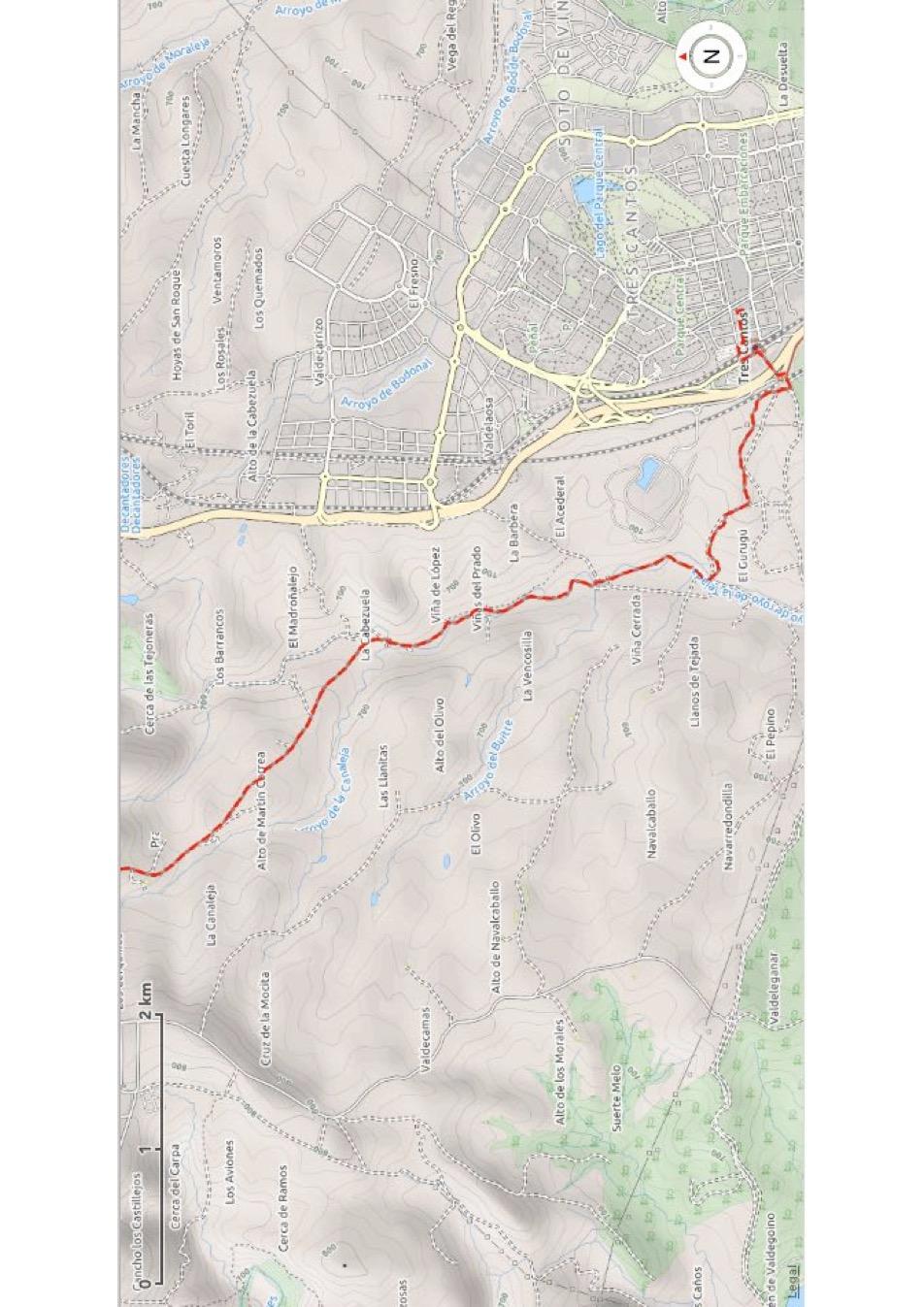
1 Stage 2: Following the royal cattle route towards the medieval castle of the Mendozas. Tres Cantos to Manzanares el Real 25,1 km, 6,5 hrs, é513m, ê344m, ñ m 0,0 km ñ745m Tres Cantos tvsäã 0,9 km ñ748m Junction onto Camino 10,5 km ñ881m Colmenar Viejo tvsäã 17,3 km ñ852m Medieval bridge S 25,1 km ñ911m Manzanares el Real vsäã P The route goes mainly over dirt roads and farm tracks, with short pieces of asphalt. Between Colmenar Viejo and Manzanares some sections are quite stony and there is a significant climb. Albergues: Manzanares el Real: None. The albergue Peña Sacra is at the moment closed. For pilgrim accommodation you will have to continue seven kilometres to Mataelpino. Hotels: Colmenar Viejo: Hostel El Chiscón, Calle de los Frailes 89, tel Private house at Andrea s, rooms and bunkbeds, tel / Manzanares El Real: Residencia La Pedriza, Calle de Urumea 8, outside the city centre on the camino, tel Mirador La Malaciosa, Avenida La Pedriza 60, pleasant place with wooden chalets, tel Hotel Rural El Yelmo, further down the road at Avenida La Pedriza 67, tel The large hotel Parque Real was closed at the time of research. Campings: Manzanares El Real: El Ortigal, on the north side of town close to the granite walls, Calle de los Montañeros 19, tel Leave Tres Cantos retracing your steps back over the bridge out of town. Proceed on the path next to the waterworks and behind the building turn right and continue next to the railroad. After 200 meters at a junction turn left. Continue for 1,5 kilometres


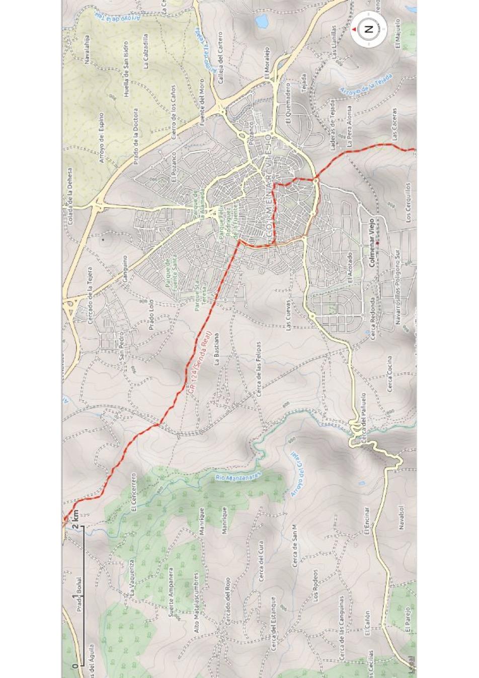
2 until the bottom of the valley. Cross the stream and then keep right following the path along the river. You cross the stream multiple times, with Colmenar Viejo already visible on the horizon. Pass a few farms, where you ignore all side roads and eventually you arrive on an asphalt road next to the cemetery of Colmenar Viejo. Continue for one kilometre until a roundabout, where you cross on the right side and follow the sign towards centro urbano. After passing a school turn left in Calle Santa Ana. Follow this road upwards, passing behind the basilica, and turn left onto the square next to it. The Basilica of Colmenar Viejo: The church dates from the 15 th century and has been erected in gothic style under the watchful eye of the Mendoza family who resided in the castle of Manzanares. Its size, with three naves is enormous considering the small village where it has been build. The altarpiece is especially unique, which consist of three panels. They were crafted between 1566 and 1579 by various artists. This was the result of the early death of their predecessors, apparently is was not a lucky assignment. The basilica is accessible between 09:00 and 13:00 or at night during mass. A small museum in the back can also be visited during the morning hours. Pass the fountain and walk into Calle del Reloj, which continues as Calle Colmena del Cura. At the miniature roundabout continue straight ahead and where the road splits, keep right into Calle Jacinto Benavente. You arrive at a crossing where you turn left and then immediately right again into Avenida de América. Arriving at a park cross it diagonally and turn right onto the wide road. Cross two roundabouts straight and at the third turn left into Calle Pilar de Zaragoza. At the end continue on the sand track and you pass a fantastic wall painting with the first two phrases of a poem by Antonio Machado: Caminante son tus huellas el camino y nada mas; Caminante no hay camino, Se hace camino al andar. Walker, there are your footprints the path and nothing else; Walker, there is no path, the path is made while walking.

.")
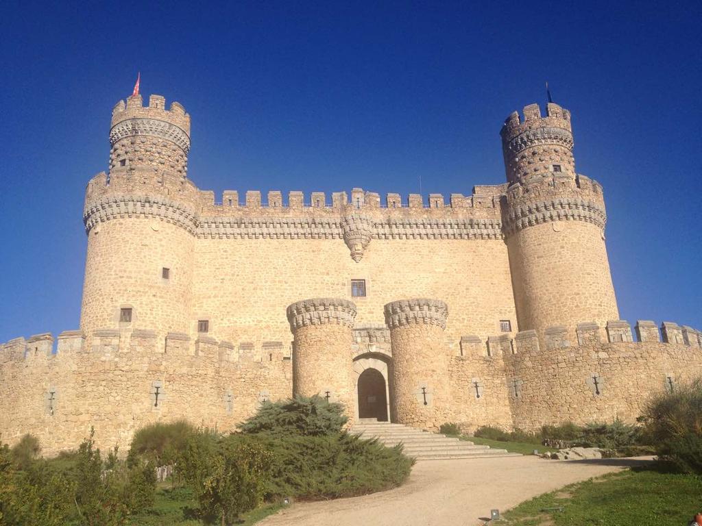
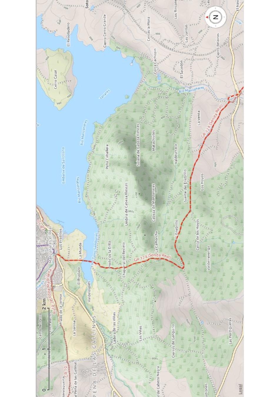
3 After crossing the second asphalt road you continue on the path just left of the park. On this path you leave Colmenar Viejo behind and proceed on a dirt road. Follow this for over a kilometre and where it splits fork right. Continue on the path all the way down towards a railway tunnel. From here you continue for two kilometres on the stony but very nice path until you arrive at a busy provincial road. In front of the barrier turn left and then ignore a path on the left (careful, there is a misplaced yellow arrow!). Instead continue straight ahead underneath the road, fork left and cross the medieval bridge. From the bridge climb up the path and turn right. A bit further in the curb of a dirt road keep left and at the next junction fork left again. In front you can see the dam of the Santillana reservoir. Follow the wide dirt road for four kilometres; a tough climb. At a junction with small powerlines overhead and a cattle water trough you turn right and continue the climb for a little more until Manzanares el Real finally comes into view. Descent in the direction of the village and arriving at the asphalt road continue straight ahead over the bridge. At the roundabout continue straight ahead and cross the bridge to head into town. (The Camino de Santiago turns left in front of the bridge). If you are going to the camping or one of the two hotels on Avenida La Pedriza, take the first road to the left after the bridge and continue for about a kilometre. The church and city hall are on the main square straight ahead and the castle is a bit further down. Castillo nuevo de Manzanares el Real The crown jewel of Manzanares is the castle which was built in 1475 by the Mendoza family. It replaces an earlier castle; of which you can see the foundation when you leave the village on the camino. Firstly, the castle was used as a defensive fortress, but the rulers decided to add some decorative elements and turn the castle into a pleasant place to live. Most notably the balcony on the south side was added in baroque style and has great views over the lake. At the end of the 16 th century the castle, like most in Spain, entered into decline. What you see today is the result of two extensive reconstructions in the 20 th century. Visiting hours are between 10:00 and 17:00. Entry is 5 euros (3 euros for over 60).
4
5
6
7
Stage 1: Through the streets of Madrid Madrid to Tres Cantos
 Stage 1: Through the streets of Madrid Madrid to Tres Cantos 24,7 km, 6 hrs, é364m, ê272m, ñ638-762m 0,0 km ñ660m Church of Santiago tvsäã 10,1 km ñ709m Fuencarral tvsäã 19,0 km ñ742m El Goloso tsä 23,8
A Circular Walk from Chapel Carn Brea
 A Circular Walk from Chapel Carn Brea 4.3 Miles A Walk Visiting Five Historic Ancient Sites This circular walk offers the possibility of several alternatives, depending on the walker s available time and
This path goes past an old tree nursery and sawmill. After 800m it crosses over a lane. Follow the bridleway fingerpost into the woods.
 FRENSHAM PONDS 11K CIRCULAR TRAIL 2½ HRS GU10 2DA This magnificent heathland trail starts in woodland and then brings you out onto the open heather of Frensham Common, with no roadwork! The route runs
Hay Wood, Rowington and Baddesley Clinton - Warwickshire
 Hay Wood, Rowington and Baddesley Clinton - Warwickshire Starts at Lay-by alongside Hay Wood 2 hours 30 minutes 5.5miles 8.8km Leisurely ID: 0.683 Developed by: John Clift Checked by: Andy Page www.ramblersroutes.org
Things to see around the Parador de Sigüenza
 Culture & History - Discovering Spain Castile-La Mancha - Castles - heritage - historic hotel - historic location - historic Spanish city - holiday in Spain - medieval town - nature - nature park - Parador
Slad over to Pitchcombe and back
 The walk climbs up from Slad over Wickridge Hill, descends to near Pitchcombe, then climbs back over Wickridge hill and round the back of Slad. Page 1 Start Point: SO 8718 0732 The Woolpack, Slad Length:
BAHIA DE LA CONCHA / THE CONCHA BAY: From Chillida to Oteiza
 BAHIA DE LA CONCHA / THE CONCHA BAY: From Chillida to Oteiza La Concha (The Shell) Bay is one of the most beautiful promenades of Spain. For many years it was the favourite place of the Spanish monarchy
El Camino San Olav. A Walker's Guide
 El Camino San Olav A Walker's Guide By Alf Alexander Pedersen aka AlexWalker tel +47 930 26993 Introduction. The way of San Olav is an easy 3-day walk from Burgos to Covarrubias in Spain, to the tomb of
San Miguel to Caserio de la Hoya Circular (San Miguel)
") Tenerife Sur: Short Walks Under 10 km San Miguel to Caserio de la Hoya Circular (San Miguel) Route Summary An informative and scenic walk back in time from San Miguel to below El Roque, overlooking the
Tenerife Sur: Short Walks Under 10 km San Miguel to Caserio de la Hoya Circular (San Miguel) Route Summary An informative and scenic walk back in time from San Miguel to below El Roque, overlooking the
Ala-Kul trekking guide.
 Ala-Kul trekking guide. The marshrutka 101 brings you to the entrance of the park. For 400 KGS, a taxi will stop between the entrance and the broken bridge, saving at least 1 hour of walk. Download me
Hindhead, Keffolds Copse and Gibbet Hill
 point your feet on a new path, Keffolds Copse and Gibbet Hill Distance: 6 km=4 miles Region: Surrey Author: Schwebefuss Refreshments: Punch Bowl Café moderate walking Date written: 14-apr-2015 Last update:
CWMGIEDD FROM ABERCRAVE
 Abercrave to Cwmgiedd Walk Page 1 Starting from The Abercrave Inn. Grid Ref: SN 824128 From the Abercrave Inn, an 11.3km (7 miles) walk to the foothills of the Cribarth Mountain, then through forest to
Porto - Santiago de Compostela
 Pilgrimage Camino Portugues Porto - Santiago de Compostela When: April 26 May 9, 2019 Duration: Distance: Guide: 14 days; 11 days of walking total: 195 km / 121 mi; average a day: 15 24 km / 9 14 mi Gerard
Leaden Boot Challenge ROUTE INSTRUCTIONS
 Leaden Boot Challenge ROUTE INSTRUCTIONS Section 1 Alstonefield to Ilam From the village hall car park turn R then L and pass through the village keeping to the R to enter Church Street. Pass the Church
Directions to Soil Judging Practice Pits. Lost call Jim Turenne cell , pit location are posted at:
 Directions to Soil Judging Practice Pits. Lost call Jim Turenne cell 401-255-6206, pit location are posted at: http://maps.google.com/maps/ms?hl=en&ie=utf8&msa=0&ll=41.508577,- 71.523743&spn=0.447349,0.829468&z=10&msid=113798583893585652288.0
Sponsored by. statestreet.com
 /STATESTREETISLANDWALK #ISLANDWALKJSY Sponsored by statestreet.com Important Information If you forget everything else PLEASE remember the following.» Remember to check OUT of every checkpoint» If you
Reigate Hill and Gatton Park
 point your feet on a new path Reigate Hill and Gatton Park Distance: 11½ km=7 miles easy-to-moderate walking or 2 walks of 6½ km=4 miles and 5½ km=3½ miles Region: Surrey Author: Schwebefuss Refreshments:
Ardingly Lake, Ouse Valley, Borde Hill
 point your feet on a new path Ardingly Lake, Ouse Valley, Borde Hill Distance: 14 km=9 miles or 12½ km=8 miles Region: West Sussex Author: Hautboy Refreshments: Borde Hill Map: Explorer 135 (Ashdown Forest)
Bewl Water & the High Weald
 1 Bewl Water & the High Weald Stonegate station - Stonegate - Wallcrouch - Newbarn - Cousley Wood - Wood's Green - Wadhurst station Length: 9 ½ miles (15.3km) Underfoot: Large portions of this path are
Lava Mountain Trail Distance: Elevation Range: Trail Type: Difficulty: Season: Driving Distance: Driving Time: USGS Maps: Pros Cons
 Lava Mountain Trail Distance: 13.4 miles (including the side trip to North Star Lake) Elevation Range: 5900'-8330' Trail Type: singletrack Difficulty: moderate Season: late June-October Driving Distance:
Spain Tour. Waubonsie High School Band. Trip Highlights. December Mark Duker, Kevin Carroll, Chris Dandeles, Directors
 Waubonsie High School Band Mark Duker, Kevin Carroll, Chris Dandeles, Directors December 2017 Spain Tour Trip Highlights Guided tour of Barcelona, Montserrat, Zaragoza, Madrid, Toledo and Segovia Admission
HARDMOORS 55 RACE ROUTE 2018 HELMSLEY - GUISBOROUGH
 HARDMOORS 55 RACE ROUTE 2018 HELMSLEY - GUISBOROUGH HELMSLEY - CHECKPOINT 1 (WHITE HORSE) 1. Leave RACE START, continue ahead on road (Baxtons Sprunt) At crossroads turn right down Canons Garth eventualy
Cragg Vale to Todmorden
 Cragg Vale to Todmorden Map Co-Ordinates : SE 002232 The Te Duem Stone near Stoodley Pike symbolises a long tradition of wayfaring. Crossing the the Pennine Way, the route drops down towards Lumbutts and
START / FINISH Irvine Valley College. 100 Mile Course Map
 START / FINISH Irvine Valley College 100 Mile Course Map ELEVATION MAP 100 MILE COURSE 100Mile Total Dist Direction / Street Name 0 Start at Irvine Valley College 0.2 Right onto Jeffrey Road 3.7 Left on
The Hundred Parishes
 The Hundred Parishes Walks from railway stations number 3 3 miles (5kms) circular walk from Stansted Mountfitchet Start & finish: Stansted Mountfitchet station. Ordnance Survey Explorer Map 195. Grid Reference:
Grand Spain Discovery Tour
 COMBINED TRAIN TOUR Grand Spain Discovery Tour Madrid - Seville - Cordoba - Valencia - Barcelona on AVE Option Extra Nights in Madrid 12 Days / 11 Nights The Price Includes Private transfers, Madrid airport
The Mendip Way. Route Directions and Maps Uphill to Wells
 The Mendip Way Route Directions and Maps Uphill to Wells Website: www.mendiphillsaonb.org.uk Email: mendip@mendiphillsaonb.org.uk Facebook & Twitter: @MendipHillsAONB Phone: 01761462338 1 Uphill to Loxton
Leaden Boot Challenge 2016 ROUTE INSTRUCTIONS
 Leaden Boot Challenge 2016 ROUTE INSTRUCTIONS Section 1 Alstonefield to Ilam (CP2) From the village hall car park turn R then L and pass through the village keeping to the R to enter Church Street. Pass
Portuguese Way to Santiago HISTORICAL COASTAL FOODIES SUMMER
 Portuguese Way to Santiago HISTORICAL COASTAL FOODIES SUMMER 2018 www.portugalnaturetrails.com info@portugalnaturetrails.com Portuguese Way to Santiago HISTORICAL COASTAL FOODIES SUMMER DESCRIPTION The
For more information and to buy this book click here ISBN: CICERONE. Guides for walkers, trekkers, mountaineers, climbers and cyclists
 For more information and to buy this book click here ISBN: 9781852844103 CICERONE Guides for walkers, trekkers, mountaineers, climbers and cyclists www.cicerone.co.uk SALÈVE AND VALLÉE VERTE SALÈVE WALK
PLACES TO VISIT FROM SAN FRANCISCO, 71 IN DISTANCE ORDER (distance and driving times are approximate)
") PLACES TO VISIT FROM SAN FRANCISCO, 71 IN DISTANCE ORDER (distance and driving times are approximate) 1. Rio Chillar 2 km, 4 mins A peaceful walk close to the apartment. The Rio Chillar eventually flows
PLACES TO VISIT FROM SAN FRANCISCO, 71 IN DISTANCE ORDER (distance and driving times are approximate) 1. Rio Chillar 2 km, 4 mins A peaceful walk close to the apartment. The Rio Chillar eventually flows
ID: 283 Distance: 6.2 miles Height gain: 500 Metres Map: Explore OL 19 Contributor David and Chris Stewart
 Walkingworld Wild Boar Fell ID: 283 Distance: 6.2 miles Height gain: 500 Metres Map: Explore OL 19 Contributor David and Chris Stewart Features Birds, Great Views, Hills or Fells Description: Wild Boar
Hiking Las Vegas.com
 Hike: Mt. Wilson via First Creek Canyon route Trailhead: First Creek marked Distance: 10 miles up and back Elevation gain: 3,400 feet Elevation of Peak: 7,070 feet Time: 7 to 9 hours (up and back) Difficulty:
BISHOPSTONE CIRCULAR WALK
 BISHOPSTONE CIRCULAR WALK 4½ miles (7¼ km) - allow 2 hours (see maps on final pages) Introduction This walk is within the North Wessex Downs Area of Outstanding Natural Beauty and starts from the small,
A Tour of the Valle del Gizio
 Walk 25 A Tour of the Valle del Gizio Walking time 5hrs 30mins (4hrs if Colle Mitra is omitted) Difficulty 2 (likely to be snowbound in winter months); 1 (if Colle Mitra is omitted) Ascent/descent 570m/570m
GRINDLEFORD GALLOP 2018
 GRINDLEFORD GALLOP 2018 Route Information The Grindleford Gallop follows a fixed 21 mile route through the lanes and paths of Derbyshire. All competitors must follow this route. An OS map of the area with
Tenerife Sur: Short Walks Under 10 km. Cabo Blanco - La Camella Circular (Arona) Route Summary. Route Overview. Description
 Route Summary. Route Overview. Description") Tenerife Sur: Short Walks Under 10 km Cabo Blanco - La Camella Circular (Arona) Route Summary An interesting town and country walk, with some marvellous views, in a well-populated residential area close
Tenerife Sur: Short Walks Under 10 km Cabo Blanco - La Camella Circular (Arona) Route Summary An interesting town and country walk, with some marvellous views, in a well-populated residential area close
San Luis Obispo. Bishop Peak Felsman Loop Eagle Rock Maino Open Space Poly Canyon Poly P Other Areas
 San Luis Obispo Bishop Peak Felsman Loop Eagle Rock Maino Open Space Poly Canyon Poly P Other Areas 1 JCT. ELEV. 72 400 00 0 FELSMAN LOOP GATE LOOP RIDGE 600 FENCE JCT. ELEV. 860 1000 1200 BISHOP PEAK
Dehesa Vieja and the Los Molinos area give us the gift of one of the finest
 ROUTE Dehesa Vieja and the Los Molinos area give us the gift of one of the finest beauty spots in our town. Recent history brings paradoxes: a short time ago, this place that now offers us so much beauty
Pontfadog. Walk A. Walk A
 Walk A A Bird s eye view of the village 2km. (1 1 /2 miles); height gain 45m. (150ft) about 45 minutes. Six minutes walk along the main road towards Glyn Ceiriog reach a signpost to Llwynmawr. Take the
Griffith Park Trail Run Trail Guide Click for
 The Griffith Park Trail Run by Hike- LosAngeles.com Griffith Park Trail Run Trail Guide Click for downloadable cell phone guide and map from EveryTrail. DISTANCE: 4.55 Miles ELEVATION: 1280' ELEVATION
The Cleo s Bath North Side Hike
 The Cleo s Bath North Side Hike This hike is a cross-country hike from Pinecrest Lake to the north side of Cleo s Bath. It is quieter and much less crowded than the normal route, which goes up the south
Driving instructions to Kotor Vista and Kotor Muo from Dubrovnik airport
 Driving instructions to Kotor Vista and Kotor Muo from Dubrovnik airport We will assume you are coming straight from the airport. If you are not doing so, please inform us so we can plan accordingly. Turn
Self-Guided Walk Langdale Pikes. Start & Finish: NT car park (free to members) at Sticklebarn - on the right just beyond the New Dungeon Ghyll hotel.
 at Sticklebarn - on the right just beyond the New Dungeon Ghyll hotel.") Self-Guided Walk Langdale Pikes Key Information These mountains form a collection of spires and cliffs on the north side of Langdale. This walk visits four of the main tops Pavey Ark, Harrison Stickle,
Self-Guided Walk Langdale Pikes Key Information These mountains form a collection of spires and cliffs on the north side of Langdale. This walk visits four of the main tops Pavey Ark, Harrison Stickle,
INTRODUCTION ITINERARY ARGENTINA - TREKKING TO THE CLOUDS TRIP CODE ARTSTTC DEPARTURE DURATION. 4 Days LOCATIONS. Argentina
 INTRODUCTION Live this amazing experience in the NorthWest region of. Walking in the mountains through the ancient Inca trail, this journey will take you to discover ruins, spectacular views and landscapes.
CAMINO DE SANTIAGO detailed program Includes:
 CAMINO DE SANTIAGO detailed program 2018 Madrid - Santiago de Compostela or Madrid 8 days / 7 nigths Guaranteed routes with 6 people or private groups. Kilómeters: 101 kilometers (you can get the Compostela)
MARMOLEJO/ VIRGEN DE LA CABEZA SIERRA MORENA TRAIL: PROVINCE OF JAÉN
 SIERRA MORENA TRAIL: PROVINCE OF JAÉN 34 STAGE 1: MARMOLEJO/ VIRGEN DE LA CABEZA This first stage of the GR-48 trail through the province of Jaén starts off at Marmolejo town and finished at the Virgen
CAMINO DE SAN SALVADOR MAY 2017
 CAMINO DE SAN SALVADOR MAY 2017 General The Camino is approx. 120ks long from Leon to Oviedo and can be walked in 4, 5, or 6 days, as there is accommodation en route either private or in albergues. The
Camino Portugués in Spain
 Camino Portugués in Spain Camino 1st class with Sanne from Tui at the Portuguese/Spanish border to Santiago sanne-vandreture.com I simply love Galicia and to walk here in the footsteps of the pilgrims.
Top 5 most beautiful towers at Paradores for asking for marriage in Spain
 Culture & History - Discovering Spain Alarcón - Architecture - Castells - historic location - History - Parador Alarcón - Parador Jaén - Parador Jarandilla de la Vera Parador Olite - Parador Oropesa -
Atlantic Way to Santiago HISTORICAL COASTAL SUMMER
 Atlantic Way to Santiago HISTORICAL COASTAL SUMMER 2018 www.portugalnaturetrails.com info@portugalnaturetrails.com Atlantic Way to Santiago ADVENTURE NATURE DESCRIPTION Riding on the most interesting and
The 34 th Poppyline Marathon
 The 34 th Poppyline Marathon Saturday 9th June 2018 - Route Description Emergency number: 07906 404673 or 07597 052572 Ahd - Ahead BL - bear left BR - bear right BW - bridleway Cont - continue FB - footbridge
GEMONA DEL FRIULI CAVAZZO LAKE
 MTB Friuli Gemona del Friuli - Venzone - San Simeone Mount - Cavazzo Lake - Bordano GEMONA DEL FRIULI CAVAZZO LAKE 1 of 6 9/1/17, 11:21 AM MTB Friuli Gemona del Friuli - Venzone - San Simeone Mount - Cavazzo
Excursions CANARY ISLANDS
 Excursions CANARY ISLANDS TEIDE - MASCA GARACHICO Leaving towards la Villa and Puerto de Garachico (Castillo San Miguel, Iglesia Santa Ana, Convento San Francisco,...). Los Silos, Buenavista del Norte
CAMINO TO FINISTERRE / FISTERRA
 CAMINO TO FINISTERRE / FISTERRA The extension of the Way of Saint James to Cape Finisterre also known as Fisterra in Galician Follow the 88 km (55 miles) of the Finisterre Way from the Cathedral of Santiago
Merritts Traverse. 1928m
 Merritts Traverse 3 hrs Hard track 5.8 km Circuit 4 167m This walk starts with a scenic journey to the top of the hill on the chairlift. Starting along Merritts Nature walk, this walk soon detours down
The town of Fuente de Cantos is located in the region Badajoz of Spain.
 Badajoz route: Monesterio and surroundings Day 1 Fuente de Cantos The town of Fuente de Cantos is located in the region Badajoz of Spain. The Town is located on the old road N-630, now highway A-66, about
Lake Garda as the one offered by Rifugio San Pietro, which is located at the south hillside. view out of an airplane. beautiful panorama.
 There is no better view of Lake Garda as the one offered by Rifugio San Pietro, which is located at the south hillside of the Monte Calino. Also a view out of an airplane cannot compete with this beautiful
Potato Chip Grinder. Sheet1
 Potato Chip Grinder MILE DIRECTIONS FOR 0 START: Albertsons 5 Woodland Pkwy San Marcos, CA. (OPEN:00:00 CLOSE:+0:00) Obtain proof of start from local business with time & date stamp. Exit parking lot toward
Tenerife Sur: Short Walks Under 10 km. Casa del Ancon Circular (Arona) Route Summary. Route Overview. Description
 Route Summary. Route Overview. Description") Tenerife Sur: Short Walks Under 10 km Casa del Ancon Circular (Arona) Route Summary This short circular walk from Arona is very scenic, with reminders of rural life in previous times. Route Overview Duration:
Tenerife Sur: Short Walks Under 10 km Casa del Ancon Circular (Arona) Route Summary This short circular walk from Arona is very scenic, with reminders of rural life in previous times. Route Overview Duration:
The area around B&B La Fossa in Vetto
 The area around B&B La Fossa in Vetto Walking tracks (with descriptions), restaurants, swimming, castles, opening times, supermarkets, petrol station. Walking track: Ring of Spigone Departure: B&B La Fossa
Map: Landranger #27 Forres and Nairn and 36 Grantown and Aviemore
 THE DAVA WAY This is a newly created long distance route that runs from Forres to Grantown, mostly following the old railway line. You will need to detour around a couple of sections that are not really
Walking Tour #1. Las Palmas & Spanish Town. *Additional time if you include optional meals and/or swimming.
 Walking Tour #1 Las Palmas & Spanish Town This tour takes you from the town monument through the old Chiquita executive neighborhoods of Las Palmas (La Zona) and Spanish Town (Buena Vista). You are welcome
CITY TOUR. Date: November 28th Pick up: 09:00 Duration: 8 hrs. Price per person: USD Min. 10 pax
 CITY TOUR Date: November 28th Price per person: 98.00 USD We will walk around Mexico City s main square, heart of the Nation where prehispanic ruins, colonial buildings and modern life coexist. We will
Spain Tour. Waubonsie High School Band. Trip Highlights. December Directors - Mark Duker, Kevin Carroll, & Chris Dandeles
 Waubonsie High School Band Directors - Mark Duker, Kevin Carroll, & Chris Dandeles December 2017 Spain Tour Trip Highlights Guided tour of Barcelona, Montserrat, Zaragoza, Madrid, Toledo and Segovia Admission
Black Hill Regional Park, Little Seneca Lake
 Black Hill Regional Park, ittle Seneca ake ittle Seneca ake, in Black Hill Regional Park, is a reservoir created after a previous drought struck the Washington area. The park is under Maryland-National
C E N T R A L C A T S K I L L S
 120 C E N T R A L C A T S K I L L S Central Catskills Once out of the southern parts of the Catskills, the Long Path enters the more well traveled and civilized regions. The trail joins the Devil s Path,
Best hotels in Spain located in a medieval environment
 Culture & History - Discovering Spain Basque Country - Castile-La Mancha - Castles - heritage - historic hotel - historic location - historic Spanish city - History - luxury hotels - medieval town - Navarre
UMASS CROSS-COUNTRY Trails
 UMASS CROSS-COUNTRY Trails 1) EGG (43 min) (A) From Cage proceed to North Pleasant street (by campus pond). Make left and head toward LGRT and pass School of Education. Pass Puffton Apt complex (on left)
Medway Valley Orchards
 1 Medway Valley Orchards East Farleigh station - Kettle Corner - Farleigh Green - Buston Manor - Yalding - Yalding station Length: 6 ¾ miles (10.9km) Underfoot: Generally, this is a walk on good paths,
EL GHENESA (THE CHURCH) OF GEBEL KHALAK
 OF GEBEL KHALAK") Going through Gebel Khalak is a tradition for us, or better to say a well established habit. Whether coming down from the path of the oil getting along the old track of water or going around the ridge
Going through Gebel Khalak is a tradition for us, or better to say a well established habit. Whether coming down from the path of the oil getting along the old track of water or going around the ridge
Difficult Run Stream Valley Park
 Difficult Run Stream Valley Park The more intense mountain bikers have known about for Difficult Run for some time. Equestrians have known it longer. Eight miles of unpaved trail, the Rails to River Trail
The. History Walk. WWII Armaments factory
 The History Walk WWII Armaments factory 4.8-6.5 kilometres (3-4 miles) 2.5-3.5 hours Terrain: easy Can be slippery when wet No stiles Unsuitable for a pushchair/wheelchair Uses OS map 197 Parking: Pulborough
Information For Planning A Trip To The Tehachapi Loop. Jeff Williams September, 2016
 Information For Planning A Trip To The Tehachapi Loop Jeff Williams September, 2016 Note: This slide show is a scaled down version of the presentation made to the San Jacinto Model Railroad Club September
The map views below show where the apartment is located.
 FUENGIROLA LA JOYA WINTER 2017 2018 This winter we had decided to stay in Fuengirola, Spain. We had found an apartment (Link 1 Link 2) which we thought looked nice. It is located a little south of the
beach. Make the ford and follow the trail out to the junction with Red Creek Tr in an open grassy area.
 Description: This is a moderate to slightly strenuous 22.8 mile backpack (add 2.6 miles if you do the packless out and back to the Lion s Head) that will have you exploring nearly every thing that is The
Staples Lookout to Mt Wondabyne loop
 Staples Lookout to Mt Wondabyne loop 4 hrs 3 mins 1.8 km Circuit Hard track 337m This walk starts and finishes at Staples Lookout, on Woy Woy Rd. The walk follows sections of the Great North Walk around
BACKROADS BICYCLE/AUTOMOBILE TOUR OF MIDDLESEX, VERMONT
 BACKROADS BICYCLE/AUTOMOBILE TOUR OF MIDDLESEX, VERMONT (created and published by the Middlesex Historical Society) Welcome to a 25-mile self-guided historical tour of the backroads of Middlesex. You may
Alpujarras walking trip - Spain
 S-CAPE TRAVEL - EMAIL: INFO@S-CAPETRAVEL.EU - TELEPHONE +34 985846455 - WWW.S-CAPETRAVEL.EU style : level : duration : comfort : period: code: WALKING Selfguided 7 days Feb Mar Apr May Jun Aug Sep Oct
NORTHERN SPAIN. Barcelona, Tarragona, Lerida, Zaragoza, Pamplona, Bilbao, Burgos.
 NORTHERN SPAIN Barcelona, Tarragona, Lerida, Zaragoza, Pamplona, Bilbao, Burgos. NORTHERN SPAIN Barcelona is the cosmopolitan capital of Spain s Catalonia region. Known for its art and architecture and
Day 2 Parque Nacional de los Glaciares As many of you already know this area is declared by UNESCO as a world heritage site and is the number 1
 Patagonia Because of this beautiful vacation we came up with the idea with the Via Via team members to tell all our travelling fans about this trip and spectacular destination Calafate. With the foreigners
Telluride-to-Moab Alternative Singletrack Options
 Telluride-to-Moab Alternative Singletrack Options Day 1 Day 1 Alternate 1: Galloping Goose to Deep Creek. 18.4 miles, ascent 3,530ft, descent 1,388ft. This is fun, flowey, moderate to intermediate singletrack
Hadleigh Castle and Chalkwell Oaze
 1 Hadleigh Castle and Chalkwell Oaze Benfleet station Hadleigh Park Hadleigh Castle Leigh-on-Sea Chalkwell station A short stroll through the lush woods of Hadleigh Park high above the Thames-side marshes,
3.1 Bowness-on-Solway to Carlisle
 3.1 Bowness-on-Solway to Carlisle Map panel 1 Distance 15 miles (24 km) Terrain minor roads, tracks, field paths and riverside footpath, muddy in places Grade easy, with gentle gradients on undulating
FROM JUTA TO ROSHKA via Chaukhi pass
 FROM JUTA TO ROSHKA via Chaukhi pass Duration: 1-2 days The hike can take one or two days, depending on how you plan it. I will focus on the 1-day version of the trek which takes 8-9 hours and starts in
TRANS ALGARVE MTB. lagoon system that extends itself over 60km of coast with hundreds of different bird species. Discover the
 TRANS ALGARVE MTB AN ASTONISHING MTB ROUTE ALONG PORTUGAL'S SOUTHERNMOST REGION, FROM THE BORDER WITH SPAIN UNTIL SAGRES, WHERE YOU WILL REACH CAPE S. VICENTE. In the meantime, you will have a taste of
Atlantic Way to Santiago HISTORICAL COASTAL SUMMER
 Atlantic Way to Santiago HISTORICAL COASTAL SUMMER 2018 www.portugalnaturetrails.com info@portugalnaturetrails.com Atlantic Way to Santiago ADVENTURE NATURE DESCRIPTION Riding on the most interesting and
Key Information. Self-Guided Walk Corfe Castle to Swanage
 Self-Guided Walk Corfe Castle to Swanage A classic walk from the pretty village of Corfe Castle. Enjoy extensive views whilst walking along the wide ridge to the popular seaside town of Swanage, returning
Burgos route: Quintanar de la Sierra and surroundings
 Burgos route: Quintanar de la Sierra and surroundings Day 1 Barbadillo de Herreros The town of Barbadillo de Herreros is located in the region Burgos of Spain. Barbadillo de Herreros is a municipality
Aston Rowant Discovery Trail
 The walk was developed by Aston Rowant Parish Council. The Trail is stile-free and fully way-marked. The circular route is 5.3m but with the extension to a pub and hotel 6.2m. Key Main Aston Rowant Discovery
MADRID CONGRESS European Federation of Abrasive Products May, 23 rd -25 th, 2012
 SOCIAL PROGRAM MADRID CONGRESS 2012 European Federation of Abrasive Products May, 23 rd -25 th, 2012 1 DAY 1ST : Wednesday MAY 23rd MUSEUM TOUR: VISIT DEL PRADO Meeting time: 9:45 AM in lobby of the Grand
Lordenshaw. What are cup & ring marks?
 Lordenshaw Lordenshaw hill has one of the largest clusters of ancient cup and ring marked stones in the UK. We ve chosen four interesting spots we d like to share with you. What are cup & ring marks? The
Map: Kompass Hunsrück/Obere Nahe 3061 Kompass Rheinhessen Rheingau Naheland, Mainz 3089
 The Tandem Club International Rally 2017 Oberhausen/Nahe Germany GPS file: ITR17_THU_Flat_65k.gpx Soonwald flat ride 64 km 40 m This ride is long, but almost completely level! Start on Nahe CP via Bad
Mersey Valley Timberland Trail
 Route Pack Page 1 Route Summary A long distance linear walk on roads and country paths linking town and countryside to parks, woodlands and other open spaces. Grade Distance Accessibility Allow Start Map
Holiday with a religious connection: Lanzarote
 Holiday with a religious connection: Lanzarote Sculpture of Christ s Passion in the museum of religious art in the island s former capital, Teguise Town. In February 2017, Martin and Magda spent a week
Section 7: Pick Up Where You Left Off! S-Tree Road over the Todd Road
 2018 TRACE NOTES Helpful information for your adventure on Section 7 of the Hiker Challenge. Start Point S-Tree Rd. End Point Intersection Todd Rd. / Hale Ridge Rd. WEATHER DECISION Weather Alert!!!! Potential
Beamers Trail. Walk No.1. 6 miles. (easy with some moderate ascents and descents)
") Beamers Trail Walk No.1 6 miles (easy with some moderate ascents and descents) 1 BEAMERS TRAIL 6 miles (easy with som WALK The Warpers Trail forms part of the long distance Witton Weavers Way. This is
Beamers Trail Walk No.1 6 miles (easy with some moderate ascents and descents) 1 BEAMERS TRAIL 6 miles (easy with som WALK The Warpers Trail forms part of the long distance Witton Weavers Way. This is
Walking Horace Greeley s Farm A New Castle Historical Society Project
 Walking Horace Greeley s Farm A New Castle Historical Society Project A Brief History of Horace Greeley s Farm Horace Greeley, publisher of the New York Tribune, and later a candidate for President of
Most amazing castles and fortress nearby Paradores in Spain
 Culture & History - Discovering Spain Andalusia - Castles - Córdoba - cultural heritage - heritage - historic hotel - historic location - History - holiday in Spain - La Granja - luxury hotels - Madrid
FOREST EUROPE EXPERT LEVEL MEETING for the Preparations of the 7 th Ministerial Conference
 FOREST EUROPE EXPERT LEVEL MEETING for the Preparations of the 7 th Ministerial Conference 20-22 January 2015, Santiago de Compostela, Spain PRACTICAL INFORMATION Bellow you will find information on how