|
|
|
- Nigel Gilmore
- 5 years ago
- Views:
Transcription

1
2
3
4
5
6
7
8
9
10
11
12
13
14
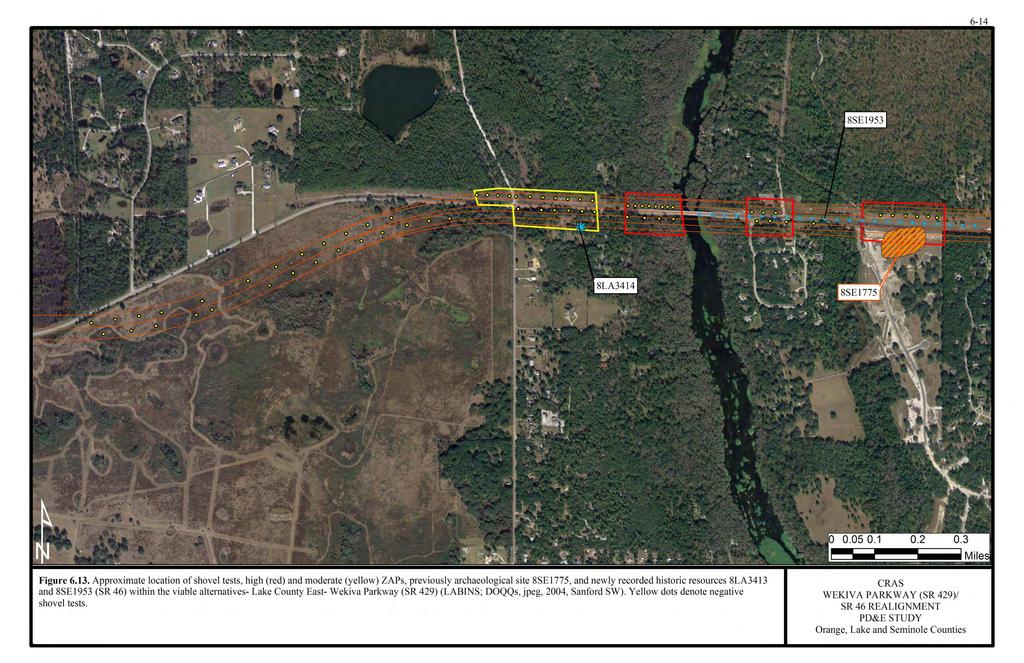
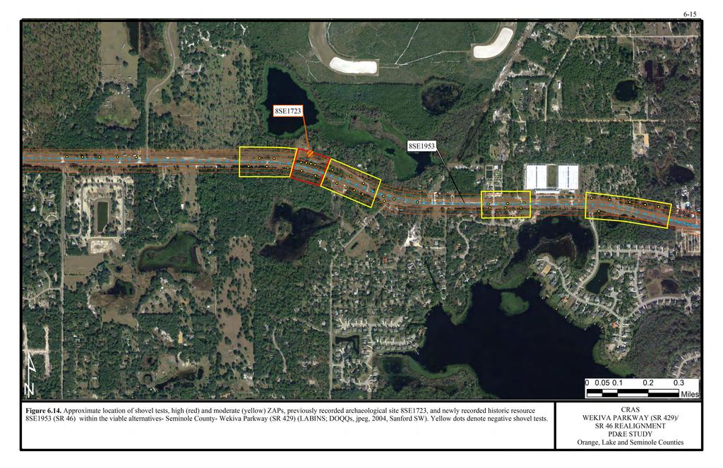
15 6-18 8SE80 This site (unnamed) is located in the northeast quarter of Section 20 in Township 19 South, Range 30 East (USGS Sanford, Fla. 1965, PR 1988) (Figure 6.1). The site occurs on Adamsville-Sparr fine sands, which are somewhat poorly drained soils that occur on the lower slopes of uplands and low knolls in the flatwoods (USDA 1990). Site elevation is between 17 and 18 m (55-60 ft) amsl. The site is located approximately 250 m (820 ft) southeast of a wetland. 8SE80 was evidenced by a single piece of St. Johns Check Stamped ceramic recovered during the survey for the Sanford 201 facilities (Dickinson and Wayne 1985). Additional subsurface testing was conducted around this find with negative results. Site significance was not evaluated by the SHPO, but the researchers indicated no further studies are required (Dickinson and Wayne 1985:20). The current archaeological investigations entailed ground surface reconnaissance and the excavation of seven shovel tests placed at 50 m (164 ft) intervals on both the north and south sides of SR 46 (Figure 6.15). No cultural materials were recovered from any of the tests. The local stratigraphy generally consists of an upper 25 cm (10 cm) of dark grayish brown sand with fill material, underlain by pale tan/gray sand to 100 cm (39 in) below surface. Utilities were noted in the eastern region of the site on the north side of State Road 46, and were avoided during subsurface testing. As a result of these investigations, no evidence of the previously recorded 8SE80 was discovered within the project APE. As such, no additional archaeological investigations are warranted. 8SE1723 The Locus BA4-01 Site is located in the southwest quarter of Section 23 in Township 19 South, Range 29 East (USGS Sanford SW, Fla. 1965, PI 1970) (Figure 6.1). It occurs on Pomello fine sand, 0-5% slopes, which is a moderately well drained soil characteristic of ridges in the flatwoods (USDA 1990). Site elevation is between 12 and 14 m (40-45 ft) amsl. The site is located 125 m (410 ft) south of Yankee Lake. This site was originally discovered through systematic subsurface testing during the Florida Gas Transmission Line project (Labadia et al. 2000). Of the 10 shovel tests excavated in this locale, two produced historic period cultural materials probably associated with a former structure which occupied this property; this structure was destroyed by fire in Recovered artifacts included asbestos shingle fragments, wire nails, porcelain, vessel glass, plate glass, sheet metal, and screws. The site was evaluated as ineligible for listing in the NRHP by the SHPO, and no additional investigations were considered warranted. The current archaeological investigations consisted of ground surface reconnaissance and the excavation of four shovel tests placed at 50 m (164 ft) intervals within the general site area (Figure 6.14). No cultural materials were recovered from any of the tests. The local stratigraphy generally consists of dark gray sand from 0-35 cm (0-14 in) below surface, grayish brown sand from cm (14-20 in), and brown sand from cm (20-30 in), UPDATED FINAL CULTURAL RESOURCE ASSESSMENT SURVEY WEKIVA PARKWAY/46 REALIGNMENT PD&E STUDY MAY 2010

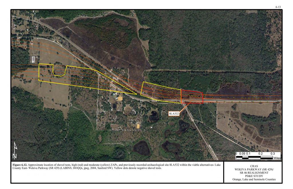
16 6-19 at which point impenetrable hard pan was encountered. The site area has been disturbed by the installation of underground utilities. As a result of these investigations, no evidence of the previously recorded Locus BA4-01 Site was discovered within the APE. As such, no additional archaeological investigations are warranted. 8SE1775 The Twin Oaks Site is located in the northeast quarter of Section 28 in Township 19 South, Range 29 East (USGS Sanford SW, Fla. 1965, PI 1970) (Figure 6.1). The site occurs on Astatula-Apopka fine sand, 0-5% slopes, which are excessively and well-drained soils of hillsides and ridges on the uplands (USDA 1990). Site elevation is between 15 and 17 m (50 and 55 ft) amsl. A wetland is located approximately 125 m (410 ft) west of the site and the Wekiva River is about 600 m (1970 ft) to the west. This historic homestead site was discovered in 2001 during a survey of the Wekiva River Parcel (Carr et al. 2001). Discovered artifacts included cut nails, whiteware, glass, stoneware, and a thimble. This late 19 th and early 20 th century period site was considered ineligible for listing in the NRHP by the SHPO, and no additional work was recommended. The current archaeological investigations consisted of ground surface reconnaissance and the excavation of six shovel tests placed at 50 m (164 ft) intervals within the general site area (Figure 6.13). No cultural materials were recovered from any of the tests. The local stratigraphy generally consists of an upper 30 cm (12 in) of dark grayish brown sand underlain by light brown or tan sand to 100 cm (39 in) below surface. Testing was performed within the archaeological APE north of SR 46. Disturbance from modern development, such as ditching and the installation of utilities, was noted within the general site area south of the existing roadway (Photo 6.1). Photo 6.1. General vicinity of 8SE1775 on south side of SR 46, looking east. UPDATED FINAL CULTURAL RESOURCE ASSESSMENT SURVEY WEKIVA PARKWAY/46 REALIGNMENT PD&E STUDY MAY 2010

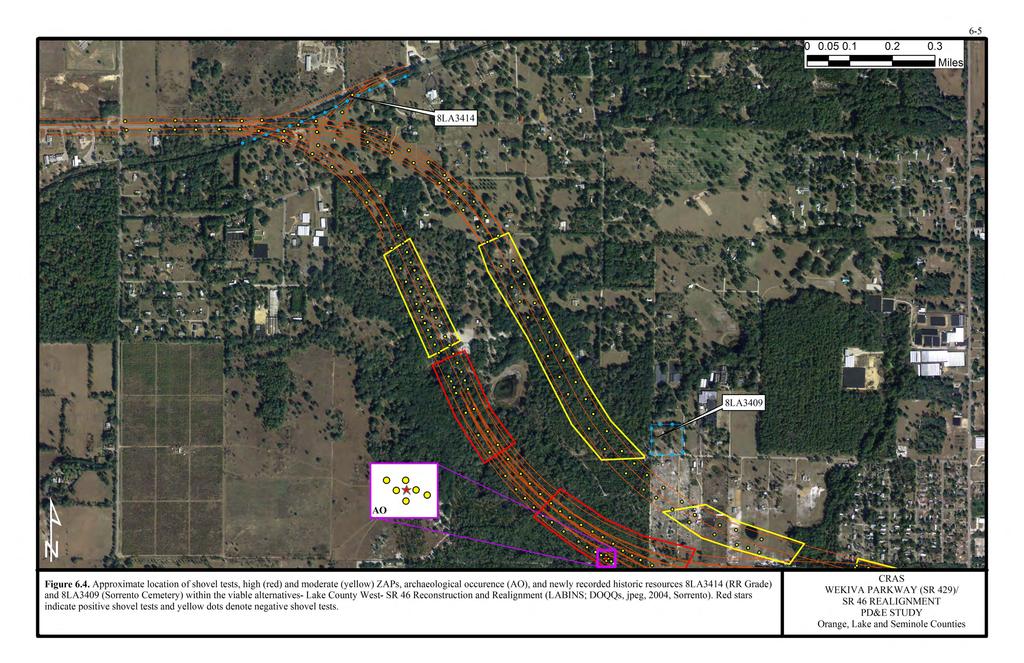
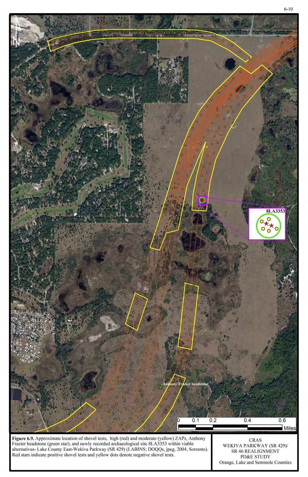
17 6-20 As a result of these investigations, no evidence of the previously recorded Twin Oaks Site was discovered within the APE. As such, no additional archaeological investigations are warranted. 6.2 Newly Recorded Archaeological Resources 8LA The Neighborhood Lakes Site is an artifact scatter located in the northeast quarter of Section 33, Township 19 South, Range 28 East (USGS Sorrento, Fla. 1960, PR 1980) (Figure 6.1). The site is located in a pasture (Photo 6.2) southeast of Mount Plymouth, south of SR 46 and east of Duxbury Avenue. It is situated on sloping terrain approximately 150 m (492 ft) north of Neighborhood Lakes. The site occurs on Astatula sand, dark surface, 0-5% slopes, a nearly level to gently sloping, excessively drained soil of upland ridges (USDA 1975). General site stratigraphy consists of an upper 20 to 25 cm (8-10 in) of gray sand underlain by 80 to 90 cm (32-35 in) of pale tan sand. Photo 6.2. General vicinity of 8LA3353. The site was initially discovered as a result of subsurface testing at 100 m (328 ft) intervals, and was delineated at 10 to 12.5 m (33 41 m) intervals. Of the seven shovel tests excavated in the area (Figure 6.9), two produced archaeological materials. One produced two St. Johns Checked Stamped rim sherds and the other yielded one nonthermally altered, chert, non-decortication flake measuring between 2 and 3 cm ( in). The potsherds were found 25 to 40 cmbs (10-16 in), and the flake was found between 70 and 90 cmbs (28-35 in). No subsurface features were observed and surface reconnaissance of the site vicinity yielded negative results. Based on subsurface testing, the Neighborhood Lakes Site is estimated to extend some 2 m (6.6 ft) north/south, by 12.5 m (41 ft) east/west. UPDATED FINAL CULTURAL RESOURCE ASSESSMENT SURVEY WEKIVA PARKWAY/46 REALIGNMENT PD&E STUDY MAY 2010
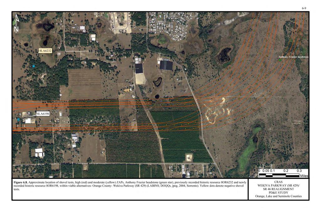
18 6-21 As the flake was recovered from a lower depth than the sherds, it is uncertain whether the artifacts are from the same culture period, settling at different rates, or if the flake was deposited at an earlier time. Although a cultural time period cannot be positively associated with the lithic artifact, the two pottery sherds would have been produced during the St. Johns II period, dated from ca. A.D. 750 to the time of European contact, ca (Milanich 1994:262). The two temperless, chalky rim sherds, which fit together, measure approximately 6.8 cm (2.6 in) in length and 0.8 cm (0.32 in) in width, and 4.4 cm (1.73 in) in length and 0.7 cm (0.28 in) in width. The location of 8LA3353 provides useful information in terms of prehistoric settlement pattern and land-use strategies. However, the sparse number and typical nature of the artifacts, as well as the lack of subsurface features, indicates that with currently available research techniques, the site has a low potential to yield further data. Therefore, the Neighborhood Lakes Site is not considered potentially eligible for listing in the NRHP and no additional investigations are warranted. Archaeological Occurrence (AO): The AO is located in the southwest quarter of Section 36 in Township 19 South, Range 27 East, in Lake County, Florida, just north of the Lake/Orange County border (USGS Sorrento, Fla. 1960, PR 1980; Figures 6.1 and 6.5). The general area, vegetated with scrub oak and palmetto, is 44 m (145 ft) to 46 m (150 ft) amsl, and within 50 m (164 ft) of a marshy wetland. The AO was evidenced by a single non-thermally altered chert, non-decortication waste flake measuring between 2-3 cm ( in) in length. It was found approximately 35 cm (14 in) below surface in very light gray sand. Four shovel tests excavated at 10 m (33 ft) intervals in the cardinal directions around the positive shovel test failed to yield additional cultural materials. 6.3 Negative Findings Preliminary reconnaissance in the Neighborhood Lakes area of Orange County by Janus Research (Janus Research 2005) resulted in the observation of an isolated gravemarker inscribed with the name Anthony Frazier and his military unit number indicating his affiliation with Company K of the 21 st U.S. Colored Infantry (U.S.C.I) (Photo 6.3). As per the National Park Service Civil War Soldier database (Janus Research 2005), Frazier held the rank of private. According to landowner Bill Cole, he found the white marble headstone lying in a field, and placed it against a nearby tree (Photo 6.4). Ground surface reconnaissance of the general area during archaeological field survey did not indicate any other markers or depressions which might suggest the presence of unmarked graves. A search of the Ancestry.com database did not reveal any Anthony Fraziers in Florida or Georgia after the Civil War. The 1870 census records indicated two Anthony Fraziers in South Carolina. The first was a 33 year old farm laborer from Blake Township in Colleton County, who resided with a wife (Sue, 22 yrs) and two children (Samuel, age 4 and Nancy, 8 mos). The other Anthony Frazier, from Sharon Township in Mecklenburg UPDATED FINAL CULTURAL RESOURCE ASSESSMENT SURVEY WEKIVA PARKWAY/46 REALIGNMENT PD&E STUDY MAY 2010
 enumerating Union Veterans and Widows of Union")

19 6-22 Photo 6.3. Anthony Frazier grave marker. County, was a 34 year old farm hand. The Special Schedules of the Eleventh Census of the United States (1890) enumerating Union Veterans and Widows of Union Veterans of the Civil War does not contain any listings for Florida or Georgia. Photo 6.4. Anthony Frazier grave marker at location of discovery in the Neighborhood Lakes area. UPDATED FINAL CULTURAL RESOURCE ASSESSMENT SURVEY WEKIVA PARKWAY/46 REALIGNMENT PD&E STUDY MAY 2010
20 6-23 The US 21 st Regimental Infantry was formed from the 3 rd and 4 th South Carolina Colored Infantry Regiments on March 14, It was attached to the 3 rd Brigade, Vodges Division, District of Florida, Department of the South. They were on duty in Jacksonville until April 1864, at which time they were transferred to Hilton Head, South Carolina, Northern District, Dept. of the South until October The 3 rd regiment was composed of ex-slaves from the Sea Islands along the coast of South Carolina, Georgia, and Florida. The majority of soldiers came from plantations in Beaufort and Hilton Head, but a good number came from the areas surrounding Savannah, Georgia and St. Simon s Island and the vicinity of Fernandina, Florida. It was organized at Hilton Head, South Carolina in June 1863, and was attached to the District of Hilton Head, 10 th Army Corps, Dept of South until January The Regiment was then assigned to Barton s Brigade, District of Hilton Head, until February 1864, when it became part of the 21 st Regimental Infantry. The 4 th regiment was organized at Fernandina and consisted mostly of ex-slaves from Jacksonville and along the St. Marys River. It was stationed at Fernandina until January 1864, at which time it was transferred to Hilton Head, until February It moved to Jacksonville, February 6-8, and became part of the 21 st regiment the following month (Dyer 1978; Gourdin 2006). Prior to and after the redesignation of the regiments, all members participated in skirmishes in South Carolina, Georgia, and Florida, the most notable of which included the Battle of Jacksonville, Florida, the battles of Honey Hills and Boykin s Mills, South Carolina, as well as several skirmishes on James and Johns Islands, South Carolina (Gourdin 2006). Florida Tract Book records indicate that an Anthony Frazier purchased the southwest quarter of Section 12, Township 20 South, Range 26 East in 1875 (Vol. 22: 244). This property is located just south of Lake Beauclaire, about 12 miles west of where the headstone was found. An internet search for cemeteries in Lake and Orange counties for an Anthony Frazier yielded negative results, as did a search of the Orange County database of Civil War soldiers as well as the Florida Civil War Master Soldier Index (Civil War Florida, Inc ). There are, however, four Fraziers listed for the Mt. Olive Cemetery near Eustis, the earliest of which is Lula ( ). The others are Peter (?-1972), Idellar ( ), and Daisy ( ). It is a black cemetery, established in Based on the results of both archival research and archaeological field survey, there is no evidence to indicate the presence of an unmarked grave or graves within the project viable alternatives. The original provenience for the Anthony Frazier headstone is unknown. The approximate location of the grave marker is indicated in Figure 6.8. UPDATED FINAL CULTURAL RESOURCE ASSESSMENT SURVEY WEKIVA PARKWAY/46 REALIGNMENT PD&E STUDY MAY 2010
Provincial Archaeology Office Annual Review
 2017 Provincial Archaeology Office Annual Review Provincial Archaeology Office Department of Tourism, Culture, Industry and Innovation Government of Newfoundland and Labrador March 2018 Volume 16 A brief
Cultural Resource Management Report Deer Valley 4wd Restoration and Blue Lakes Road Maintenance Project R
 Cultural Resource Management Report R2015-05-03-10005 Undertaking Description: The proposes to perform road maintenance and meadow restoration on the Deer Valley 4wd trail and road maintenance on the Blue
Chapter 4 Research on Block 13, Lots 3 and 4
 Chapter 4 Research on Block 13, Lots 3 and 4 George Calfas History Block 13, Lots 3 and 4 Oral history and the written record Squire McWorter acquired the deed to Block 13, Lots 3 and 4 in 1854. Squire
 Page 1 Original Update HISTORICAL STRUCTURE FORM FLORIDA MASTER SITE FILE Consult Guide To Historical Structure Forms for detailed instructions Site # 8OR9844 Recorder # 26 Recorder Date 2/20/08 Site Name
Archaeological Investigations Project South East Region SOUTHAMPTON 2/842 (C.80.C004) SU
 SU") SOUTHAMPTON City of Southampton 2/842 (C.80.C004) SU 4382 1336 125 BITTERNE ROAD WEST, SOUTHAMPTON Report on the Archaeological Evaluation Excavation at 125 Bitterne Road West, Southampton Russel, A. D
SOUTHAMPTON City of Southampton 2/842 (C.80.C004) SU 4382 1336 125 BITTERNE ROAD WEST, SOUTHAMPTON Report on the Archaeological Evaluation Excavation at 125 Bitterne Road West, Southampton Russel, A. D
Original Report F WIN , F WIN Prepared for Northland Power and Ministry of Tourism and Culture
 STAGE 2 ARCHAEOLOGICAL ASSESSMENT McLEAN S MOUNTAIN WIND FARM Part Lots 12-15, Concession 3 Geographic Township of Howland Part Lot 24, Concession 12 Geographic Township of Bidwell and Goat Island (formerly
AN ARCHAEOLOGICAL ASSESSMENT OF BOERNE CITY PARK, KENDALL COUNTY, TEXAS. Thomas C. Kelly and Thomas R. Hester
 AN ARCHAEOLOGICAL ASSESSMENT OF BOERNE CITY PARK, KENDALL COUNTY, TEXAS Thomas C. Kelly and Thomas R. Hester Center for Archaeological Research The University of Texas at San Antonio Archaeological Survey
Rappahannock River Crossing Project; Ms. J. V. Langan; May 28, 2015 Page 2 of 6
 Page 2 of 6 VDOT engaged the consultant firm McCormick Taylor to conduct the historical research and Phase I and Phase II field investigations necessary to identify and assess the significance of archaeological
Archaeological Investigation of Coloane, Macau
 Archaeological Investigation of Coloane, Macau Received 13 March 1974" W. KELLY AND W. MEACHAM INTRODUCTION UP UNTIL July 1972, when a field survey of Coloane Island was undertaken by members of the Hong
IIBANNING: A MINNESOTA STATE PARK DEVELOPMENT PROJECT RECONNAISSANCE SURVEY II E. STREIFF
 This document is made available electronically by the Minnesota Legislative Reference Library as part of an ongoing digital archiving project. http:www.leg.state.mn.uslrllrl.asp BANNNG: A MNNESOTA STATE
United States Department of the Interior National Park Service. Boundary Expansion Listed in National Register January 11, 2017
 NPS Form 10900-a (Rev. 8/2002) OMB No. 10240018 United States Department of the Interior National Park Service Boundary Expansion Listed in National Register January 11, 2017 National Register of Historic
Florida Registration No Florida Registration No
 August 22, 2007 7863 Drew Circle, Unit 5 Fort Myers, Florida 33967 Office: (239) 337-9781 Fax: (239) 337-9783 www.williamsearthsciences.com Ms. Teresa N. Puckett, P.E. District One Geotechnical Engineer
Azoria 2004 B700 Final Trench Report RQC
 Azoria 2004 B700 Final Trench Report RQC B700 is a room -2.5m by 4.5m, bounded by wall B711 to north, wall B703 to east, wall B706 to south, and wall B717 to west. B700 is an Archaic storeroom with an
Gorse Stacks, Bus Interchange Excavations Interim Note-01
 Gorse Stacks, Bus Interchange Excavations 2015 Prepared for: Cheshire West & Chester Council Interim Note-01 1 Introduction & Summary Background Since c. 2000 investigations associated with redevelopment
AN ARCHAEOLOGICAL SURVEY OF PROPOSED AREAS FOR ALTERNATE ROADWAYS AT OLMOS DAM, SAN ANTONIO, TEXAS
 AN ARCHAEOLOGICAL SURVEY OF PROPOSED AREAS FOR ALTERNATE ROADWAYS AT OLMOS DAM, SAN ANTONIO, TEXAS Dalli! Brown Center for Archaeological Research The Unh'ersity of Texas at San Antonio Archaeological
2.0 Physical Characteristics
 _ 2.0 Physical Characteristics 2.1 Existing Land Use for the Project The site is comprised of approximately 114 acres bounded by Highway 101 to the north, the existing town of Los Alamos to the east, State
Settlement Patterns West of Ma ax Na, Belize
 SETTLEMENT PATTERNS WEST OF MA AX NA, BELIZE 1 Settlement Patterns West of Ma ax Na, Belize Minda J. Hernke Faculty Sponsor: Kathryn Reese-Taylor, Department of Sociology/Archaeology ABSTRACT The focus
STATE OF IOWA. Historical and Architectural Survey for 2008 Flood Projects in Vinton, Benton County
 STATE OF IOWA CHESTER J. CULVER GOVERNOR PATTY JUDGE LT. GOVERNOR DEPARTMENT OF PUBLIC DEFENSE IOWA HOMELAND SECURITY AND EMERGENCY MANAGEMENT DIVISION DAVID L. MILLER, ADMINISTRATOR Historical and Architectural
State Level Historic Documentation Report. John Blue Bridge Hampshire County
 State Level Historic Documentation Report State Project No. S314-28-22.27 Federal Project No. BR-0028(058)D John Blue Bridge Hampshire County Prepared by: Randy Epperly, Historian Department of Transportation
Report on the excavations on the site Novopokrovskoe II in V. Kol'chenko, F. Rott
 Report on the excavations on the site Novopokrovskoe II in 2016 V. Kol'chenko, F. Rott In 2016 the Novopokrovskiy archeological group of the Institute of History and Heritage of the National Academy of
An Initial Archaeological Assessment of John James Park, City of San Antonio, Texas
 Index of Texas Archaeology: Open Access Gray Literature from the Lone Star State Volume 1977 Article 1 1977 An Initial Archaeological Assessment of John James Park, City of San Antonio, Texas Elizabeth
ARCHAEOLOGICAL INVESTIGATIONS IN GUADALUPE, NORTHEAST HONDURAS
 ARCHAEOLOGICAL INVESTIGATIONS IN GUADALUPE, NORTHEAST HONDURAS Markus Reindel, Franziska Fecher and Peter Fux Archaeological investigations in Honduras have focused on the western, Mesoamerican part of
Recent Research on Four Sites Spanning 13,000 years from Southwestern New Brunswick, Canada.
 Recent Research on Four Sites Spanning 13,000 years from Southwestern New Brunswick, Canada. Brent D. Suttie¹, Michael A. Nicholas¹, Jason S. Jeandron², Grant R. Aylesworth³, Ashley B. Brzezicki¹, and
Following the initial soil strip archaeology is sprayed up prior to planning and excavation
 Barton Quarry & Archaeology Over the past half century quarries have been increasingly highlighted as important sources of information for geologists, palaeontologists and archaeologists, both through
RESEARCH BULLETIN. Parks Canada. Parcs Canada. Cette publication est disponible en français.
 RESEARCH BULLETIN No. 201 August 1983 Scratching the Surface-Three Years of Archaeological Investigation in Wood Buffalo National Park, Alberta/N.W.T.-Preliminary Summary Report Marc G. Stevenson Archaeology,
BRONZE AGE FIELD SYSTEM AT SOUTHAMPTON AIRPORT
 Proc. Hampshire Field Club Archaeol. Soc. 65, 2010, 1-6 (Hampshire Studies 2010) BRONZE AGE FIELD SYSTEM AT SOUTHAMPTON AIRPORT By J SULIKOWSKA With contributions by LORRAINE MEPHAM and CHRIS J STEVENS
The Archaeology of Cheltenham
 The Archaeology of Cheltenham The archaeology collection of The Wilson contains a rich quantity of material relating to the prehistoric and Roman occupation of the North Cotswolds and parts of the Severn
ARCHAEOLOGICAL SURVEY PROPOSED SYCOLIN ROAD OVERPASS OF ROUTE 7/15 BYPASS LEESBURG, LOUDOUN COUNTY, VIRGINIA
 ARCHAEOLOGICAL SURVEY PROPOSED SYCOLIN ROAD OVERPASS OF ROUTE 7/15 BYPASS LEESBURG, LOUDOUN COUNTY, VIRGINIA VDOT PROJECT 6007-053-S96, B666, C501, D656, P101, R201 (UPC 99256) VDHR PROJECT: 2012-0251
oi.uchicago.edu TALL-E BAKUN
 TALL-E BAKUN ABBAS ALIZADEH After I returned in September 1991 to Chicago from Cambridge, Massachusetts, I began preparing for publication the results of 1937 season of excavations at Tall-e Bakun, one
TH E FIRST SEASON of investigations at the
 QUSEIR AL-QADIM Janet H. Johnson & Donald Whitcomb TH E FIRST SEASON of investigations at the ancient port of Quseir al-qadim on the Red Sea in Egypt took place in winter, 1978; the investigations were
Archaeology Internship in the Great Smoky Mountains National Park Summer 2010, Leila Donn
 Archaeology Internship in the Great Smoky Mountains National Park Summer 2010, Leila Donn This past summer I spent three months working as an archaeology intern in the Great Smoky Mountains National Park
ROUKEN GLEN: BANDSTAND 2015 DATA STRUCTURE REPORT
 ROUKEN GLEN: BANDSTAND 2015 DATA STRUCTURE REPORT Author (s) Ian Hill Editors Report Date June 2015 Working Partners Funders Phil Richardson East Renfrewshire Council East Renfrewshire Council, Heritage
What Is An Ecoregion?
 Ecoregions of Texas What Is An Ecoregion? Ecoregion a major ecosystem with distinctive geography, characteristic plants and animals, and ecosystems that receives uniform solar radiation and moisture Sometimes
Cholesbury New House, Parrots Lane, Cholesbury, Buckinghamshire
 Cholesbury New House, Parrots Lane, Cholesbury, Buckinghamshire An Archaeological Watching Brief For Mr Martin Wood by Sean Wallis Thames Valley Archaeological Services Ltd Site Code PLC 06/135 March 2007
An archaeological fieldwalking evaluation at Tile House Farm, Great Horkesley, Essex July-September 2005
 An archaeological fieldwalking evaluation at Tile House Farm, Great Horkesley, Essex commissioned by ADP Chartered Architects on behalf of The Ingleton Properties Ltd and Mersea Homes CAT project code:
Department of Tourism, Culture and Recreation Provincial Archaeology Office 2012 Archaeology Review February 2013 Volume 11
 Department of Tourism, Culture and Recreation Provincial Archaeology Office 2012 Archaeology Review February 2013 Volume 11 Area 14 of FjCa-14 in Sheshatshiu, portion of feature in southeast corner of
South East Region SOUTHAMPTON 3/1050 (E.80.H006) SU
 SU") SOUTHAMPTON 3/1050 (E.80.H006) SU 43351328 16 HAWKESWOOD ROAD Report on the Archaeological Observations at 16 Hawkeswood Road, Bitterne Manor Russil, A & Smith, M Southampton : Southampton City Council
SOUTHAMPTON 3/1050 (E.80.H006) SU 43351328 16 HAWKESWOOD ROAD Report on the Archaeological Observations at 16 Hawkeswood Road, Bitterne Manor Russil, A & Smith, M Southampton : Southampton City Council
MEMORANDUM. Honorable Mayor and City Councilmembers William S. Joynes, Sr., City Administrator
 AGENDA ITEM 1A MEMORANDUM DATE: January 17, 2017 TO: FROM: SUBJECT: Honorable Mayor and City Councilmembers William S. Joynes, Sr., City Administrator Sue Polka, Interim Asst. Public Works Director/City
Remote Sensing into the Study of Ancient Beiting City in North-Western China
 Dingwall, L., S. Exon, V. Gaffney, S. Laflin and M. van Leusen (eds.) 1999. Archaeology in the Age of the Internet. CAA97. Computer Applications and Quantitative Methods in Archaeology. Proceedings of
Holyport Manor Special School, Highfield Lane, Cox Green, Maidenhead, Berkshire
 Holyport Manor Special School, Highfield Lane, Cox Green, Maidenhead, Berkshire An Archaeological recording action For CgMs Consulting by Jennifer Lowe Thames Valley Archaeological Services Ltd Site Code
Table 1: Margarita (SDSU) Communication Site. Latitude 1 Longitude 1 Elev 2 Address T/R/S 3 APN 4 USGS Quadrangle
 Communication Site. Latitude 1 Longitude 1 Elev 2 Address T/R/S 3 APN 4 USGS Quadrangle") County of Riverside Public Safety Enterprise Communication Project Appendix A: Candidate Site Descriptions Margarita (SDSU) Communication Site Margarita (SDSU) Communication Site Overview The site is located
County of Riverside Public Safety Enterprise Communication Project Appendix A: Candidate Site Descriptions Margarita (SDSU) Communication Site Margarita (SDSU) Communication Site Overview The site is located
Region 1 Piney Woods
 Region 1 Piney Woods Piney Woods 1. This ecoregion is found in East Texas. 2. Climate: average annual rainfall of 36 to 50 inches is fairly uniformly distributed throughout the year, and humidity and temperatures
ARCHAEOLOGICAL MONITORING OF THE ASHBY STREET DRAINAGE PROJECT, SAN ANTONIO, BEXAR COUNTY, TEXAS
 ARCHAEOLOGICAL MONITORING OF THE ASHBY STREET DRAINAGE PROJECT, SAN ANTONIO, BEXAR COUNTY, TEXAS Anne A. Fox and I. Waynne Cox / Center for Archaeological Research The University of Texas at San Antonio
An archaeological evaluation at 14 Vineyard Street, Colchester, Essex March 2006
 An archaeological evaluation at 14 Vineyard Street, Colchester, Essex March 2006 report prepared by Ben Holloway commissioned by Colchester Borough Council CAT project code: 06/4b Colchester Museums accession
SUBJECT: State Contract No.: N06009S; Schnabel Project No.: NONCD , Stanfield Dump, Letter Report
 11-A Oak Branch Drive Greensboro, NC 27407 December 4, 2009 Phone: (336) 274-9456 Fax: (336-274-9486 www.schnabel-eng.com Mr. Bruce Lefler NCDENR, Division of Waste Management 1646 Mail Service Center
Investigations at Jackdaw Crag Field, Boston Spa, SE , in by Boston Spa Archaeology and Heritage Group
 0 Investigations at Jackdaw Crag Field, Boston Spa, SE 42304632, in 2006-7 by Boston Spa Archaeology and Heritage Group www.bostonspaheritage.co.uk Preface and Summary This report records the results of
Lidar Imagery Reveals Maine's Land Surface in Unprecedented Detail
 Maine Geologic Facts and Localities December, 2011 Lidar Imagery Reveals Maine's Land Surface in Unprecedented Detail Text by Woodrow Thompson, Department of Agriculture, Conservation & Forestry 1 Introduction
Camp Jack Wright PERMANENT ORIENTEERING COURSE (2004)
") Camp Jack Wright PERMANENT ORIENTEERING COURSE (2004) WHAT IS ORIENTEERING? The skill which enables a person to navigate with a map. In the competitive sport, the winner is the person who finishes in the
Camp Jack Wright PERMANENT ORIENTEERING COURSE (2004) WHAT IS ORIENTEERING? The skill which enables a person to navigate with a map. In the competitive sport, the winner is the person who finishes in the
Environmental Assessment and Final Section 4(f)
") Environmental Assessment and Final Section 4(f) South Pleasant View Road, City of Madison County Highway M Reconstruction Cross Country Road to Prairie Hill Road Project ID 5992-09-81 September 16, 2016
Environmental Assessment and Final Section 4(f) South Pleasant View Road, City of Madison County Highway M Reconstruction Cross Country Road to Prairie Hill Road Project ID 5992-09-81 September 16, 2016
Groundwater Recharge/Discharge Y 1, 2, 3, 4, 5, 16 X Wetland appears to be a contiguous hydraulic system, draining towards Goff Mill Brook.
 Wetland Function-Value Evaluation Form Total area of wetland: Human made? No Is wetland part of a wildlife corridor? Yes or a habitat island? Adjacent land use Rt. 1, Commercial, undeveloped forest Distance
Understanding user expectations And planning for long term sustainability 1
 Understanding user expectations And planning for long term sustainability 1 What is a natural surface trail? It can be as simple has a mineral soil, mulched or graveled pathway, or as developed as elevated
David Magney Environmental Consulting
 David Magney Environmental Consulting DELINEATION OF JURISDICTIONAL WATERS AND RIPARIAN HABITATS FOR LYONS CANYON RANCH, NEWHALL, CALIFORNIA Prepared for: UNITED STATES ARMY CORPS OF ENGINEERS and CALIFORNIA
Learning Places Spring 2016 LIBRARY / ARCHIVE REPORT #1 Brooklyn Public Library. Carlos Merced INTRODUCTION PRE-VISIT REFLECTION
 Learning Places Spring 2016 LIBRARY / ARCHIVE REPORT #1 Brooklyn Public Library Carlos Merced 02.29.2015 INTRODUCTION The Brooklyn Public Library has thousands of public programs, extensive book collections,and
Appendix F Cultural Resource Consultation
 Appendix F Cultural Resource Consultation FAA Consultation Letter to the California State Historic Preservation Officer Response Letter from the California State Historic Preservation Officer STATE
Legacy Ridge Phase 1A Study January 2005
 Legacy Ridge Phase 1A Study January 2005 Introduction The purpose of the Phase IA Cultural Resources Survey was to determine the archaeological sensitivity for the Legacy Ridge project area both for prehistoric
JANDAKOT AIRPORT HERITAGE MANAGEMENT PLAN
 JANDAKOT AIRPORT HERITAGE MANAGEMENT PLAN CONSERVATION MANAGEMENT PLAN APPENDIX I Jandakot Airport Holdings Pty Ltd 16 Eagle Drive Jandakot WA 6164 Ref: CMP Appendix I Heritage Management Plan 2014 V1.Docx
Street Sweeper Dump Site, RAF Lakenheath ERL 160
 ARCHAEOLOGICAL MONITORING REPORT Street Sweeper Dump Site, RAF Lakenheath ERL 160 A REPORT ON THE ARCHAEOLOGICAL MONITORING, 2006 (Planning app. no. F/2006/0021/GOV) Jo Caruth Field Team Suffolk C.C. Archaeological
Trench 91 revealed that the cobbled court extends further to the north.
 Report on the 2013 Gournia Excavations The 2013 excavations at Gournia were conducted June 17 July 26 under the aegis of the American School of Classical Studies at Athens and the supervision of the KD
Land off Birdie Way, Rush Green, Hertford, Hertfordshire
 Land off Birdie Way, Rush Green, Hertford, Hertfordshire An Archaeological Evaluation for Bride Hall Development Limited by Sarah Coles Thames Valley Archaeological Services Site Code RGH00/ 01 January
STATE OF WASHINGTON ARCHAEOLOGICAL SITE INVENTORY FORM
 STATE OF WASHINGTON ARCHAEOLOGICAL SITE INVENTORY FORM Smithsonian Number: 45 County: Chelan Date: 6/12/2018 Human Remains? DAHP Case No.: Archaeological Sites are exempt from public disclosure per RCW
Architectural Analysis in Western Palenque
 Architectural Analysis in Western Palenque James Eckhardt and Heather Hurst During the 1999 season of the Palenque Mapping Project the team mapped the western portion of the site of Palenque. This paper
Hwy Retaining Wall/ Sea Wall. Not Eligible, see Statement of Significance Also member of listed NR district: Mantorville Historic District
 Historic Name CS # 2007 Other Name SHPO Inv # Location E and W sides of TH 57 between 6th St and 7th St Hwy District Reference City/Township County Mantorville, City of Dodge Acres Twp Rng Sec 107N 16W
South West Region GLOUCESTERSHIRE 1/405 (B.23.H005) SU
 SU") GLOUCESTERSHIRE Cotswold 1/405 (B.23.H005) SU 16559880 COTSWOLD EASTERN SPINE ROAD STAGE 4 Cotswold Eastern Spine Road Stage 4 and Horcott Road. Watkins, K Gloucester : Gloucestershire County Council Archaeology
GLOUCESTERSHIRE Cotswold 1/405 (B.23.H005) SU 16559880 COTSWOLD EASTERN SPINE ROAD STAGE 4 Cotswold Eastern Spine Road Stage 4 and Horcott Road. Watkins, K Gloucester : Gloucestershire County Council Archaeology
Barbee-Hargrave Cemetery
 Barbee-Hargrave Cemetery [Image: Barbee-Hargrave Cemetery Plaque, courtesy of Preservation Chapel Hill] Location and Land Ownership The Barbee-Hargrave Cemetery is located near the Greenwood subdivision
An archaeological watching brief on land adjacent to 50 Rosebery Avenue, Colchester, Essex May/June 2003
 An archaeological watching brief on land adjacent to 50 Rosebery Avenue, Colchester, Essex May/June 2003 report prepared by C Crossan on behalf of Highfield Homes Ltd NGR: TM 0035 2500 CAT project ref.:
HISTORIC SITE FORM HISTORIC SITES INVENTORY
 HISTORIC SITE FORM HISTORIC SITES INVENTORY 1 IDENTIFICATION Name of Property: House at 569 Park Avenue PARK CITY MUNICIPAL CORPORATION (10-08) Address: 569 Park Avenue City, County: Park City, Summit
Preliminary Site Evaluation
 Preliminary Site Evaluation 100 Acre Site, US 72 Piperton, Tennessee Power Distributor: Chickasaw Electric Cooperative August 2010 SITE DATA SHEET PIPERTON US 72 SITE (100 ACRES): LOCATION & GENERAL DESCRIPTION
Appendix E: Cultural Resources Report
 Appendix E: Cultural Resources Report Minnesota Power 15 Line Reroute Project PREPARED BY Merjent, Inc. 800 Washington Avenue North, Suite 315 Minneapolis, Minnesota 55401 Kevin Mieras, BA Kevin Gubbels,
Conservation of Critical Environmental Resources in Chatham Park
 Conservation of Critical Environmental Resources in Chatham Park Elaine Chiosso, Haw Riverkeeper Haw River Assembly Haw River As Seen From Chatham Park "Spreading southwestward from the banks of the Haw
An archaeological watching brief at the Sixth Form College, North Hill, Colchester, Essex
 An archaeological watching brief at the Sixth Form College, North Hill, Colchester, Essex July 2001 on behalf of Colchester Borough Council CAT project ref.: 01/7B Colchester Museum accession code: 2001.126
Area of Potential Effect Report
 Area of Potential Effect Report Southeastern Pennsylvania Transportation Authority (SEPTA) King of Prussia Rail, Extension of the Norristown High Speed Line Upper Merion Township, Montgomery County, and
ROUKEN GLEN: MANSION HOUSE 2013 DATA STRUCTURE REPORT
 ROUKEN GLEN: MANSION HOUSE 2013 DATA STRUCTURE REPORT Author (s) Editors Report Date May 2014 Working Partners Funders Paul Murtagh Phil Richardson East Renfrewshire Council East Renfrewshire Council,
IKLAINA ARCHAEOLOGICAL PROJECT 2016 FIELD REPORT Michael B. Cosmopoulos
 IKLAINA ARCHAEOLOGICAL PROJECT 2016 FIELD REPORT Michael B. Cosmopoulos Introduction The overarching objective of the Iklaina project is to test existing hierarchical models of state formation in Greece
Site Location and Setting
 Memorandum Date: To: From: Subject: Kristy Le, Gary Black Steve Orem Santa Teresa County Park Historic Area Traffic and Parking Study Hexagon Transportation Consultants, Inc. has completed a traffic and
The Appleton Wetland; Its Decline, Cause and Recommended Action. Appendix K: Wetland Inspection
 The Appleton Wetland; Its Decline, Cause and Recommended Action Appendix K: Wetland Inspection Report prepared by Appleton Wetland Research Group of the Mississippi Valley Field Naturalists Research Group
An Archeological Survey of the Proposed Southwestern Beltway Extension and Twelfth Street Extension Highway Route in the Vicinity of Congaree Creek
 University of South Carolina Scholar Commons Research Manuscript Series Archaeology and Anthropology, South Carolina Institute of 5-1974 An Archeological Survey of the Proposed Southwestern Beltway Extension
PCBS DELINEATION WORK PLAN
 PCBS DELINEATION WORK PLAN BLUE ISLAND NORTHEAST MIXED-USE COMMERCIAL PARK (FORMER BLUE ISLAND LANDFILL) BLUE ISLAND, COOK COUNTY, ILLINOIS PREPARED FOR: CITY OF BLUE ISLAND 13051 SOUTH GREENWOOD AVENUE
The Year in Review 2014, Beothuk Institute Inc. We have had several highlights this year. At the AGM in May there were two guest speakers, Dale
 The Year in Review 2014, Beothuk Institute Inc. We have had several highlights this year. At the AGM in May there were two guest speakers, Dale Jarvis set the stage for the story gathering that the Beothuk
American Avalanche Association Forest Service National Avalanche Center Avalanche Incident Report: Long Form
 American Avalanche Association Forest Service National Avalanche Center Avalanche Incident Report: Long Form Please send to: CAIC; 325 Broadway WS1; Boulder CO 80305; caic@qwest.net; Fax (303) 499-9618
BROOKLYN COLLEGE EXCAVATIONS AT THE NEW UTRECHT REFORMED CHURCH
 BROOKLYN COLLEGE EXCAVATIONS AT THE NEW UTRECHT REFORMED CHURCH SUMMER 2002 The New Utrecht Reformed Church is the fourth oldest church in Brooklyn. Founded in 1677, in the heart of the Dutch town of New
We are pleased to present Stattelman Trust - Todd County ± Acres Bertha Township, Todd County
 We are pleased to present Stattelman Trust - Todd County 86.90 ± Acres Bertha Township, Todd County SUBJECT PROPERTY This property to be sold by Sealed Bid Auction Owner: Stattelman Trust; Thomas Stattelman,
Daniel Morgan, Count Pulaski and General Lafayette were familiar figures
 The Willits-Andrews Farmstead (Pulaski Headquarters Site) is a Valuable, Nationally Recognized Local Landmark Daniel Morgan, Count Pulaski and General Lafayette were familiar figures The written history
Archaeological Investigations Project East Midlands Region NORTHAMPTONSHIRE
 NORTHAMPTONSHIRE 2/92 (C.34.A002) WAKEFIELD LODGE Wakefield Lodge, Northamptonshire. Archaeological Walkover Survey Bashford, D & Croft, A Oxford : Oxford Archaeology, 2001, 15pp, figs, tabs, refs Work
The Parthian newfound area review in the central part of the Iranian Plateau: Ravanj-e Josheghan-e ghali
 International Research Journal of Applied and Basic Sciences 2015 Available online at www.irjabs.com ISSN 2251-838X / Vol, 9 (9): 1517-1521 Science Explorer Publications The Parthian newfound area review
4. Bronze Age Ballybrowney, County Cork Eamonn Cotter
 4. Bronze Age Ballybrowney, County Cork Eamonn Cotter Illus. 1 Location map of the excavated features at Ballybrowney Lower (Archaeological Consultancy Services Ltd, based on the Ordnance Survey Ireland
Wessex Archaeology. Little Stubbings, West Amesbury, Salisbury, Wiltshire. Archaeological Watching Brief. Ref:
 Wessex Archaeology Little Stubbings, West Amesbury, Salisbury, Wiltshire Ref: 63280.02 March 2007 LITTLE STUBBINGS, WEST AMESBURY, NR SALISBURY, WILTSHIRE ARCHAEOLOGICAL WATCHING BRIEF Prepared for: P
Figure 1 shows the evaluation area around Tailings Basin Cells 2E/1E. Two areas were evaluated for potential wetland impacts including:
 Barr Engineering Company 4700 West 77th Street Minneapolis, MN 55435-4803 Phone: 952-832-2600 Fax: 952-832-2601 www.barr.com An EEO Employer Minneapolis, MN Hibbing, MN Duluth, MN Ann Arbor, MI Jefferson
2.0 PARK VISION AND ROLES
 2.0 PARK VISION AND ROLES 2.1 Significance in the Protected Area System Marble Range and Edge Hills provincial parks protect 6.8% of the Pavillion Ranges Ecosection, which is located in the Southern Interior
Table 1: Iron Mountain Communication Site. Latitude 1 Longitude 1 Elev 2 Address T/R/S 3 APN 4 USGS Quadrangle
 County of Riverside Public Safety Enterprise Communication Project Appendix A: Candidate Site Descriptions Overview The site is located in San Bernardino County near several communication towers in the
Table 1: Avocado Flats Communication Site. Latitude 1 Longitude 1 Elev 2 Address T/R/S 3 APN 4 USGS Quadrangle
 County of Riverside Public Safety Enterprise Communication Project Appendix A: Candidate Site Descriptions Overview The candidate area is located in Northern San Diego County, 0.65 mile south of the border
220 NOTES AND NEWS REFERENCES
 220 NOTES AND NEWS pottery uncovered in each building, the inscription (found during the 2008 season), the seal and various metal objects. The site functioned as a rich urban centre. One would expect mention
PARADISE PARK, JAMAICA
 PARADISE PARK, JAMAICA Aerial view of Paradise Park. (Photo Tony Clarke) Deep in a Royal Palm grove in one of the West Indies last remaining coastal tropical forests, Dr. William Keegan and his assistants
Unlocking Our Coastal Heritage Project: Crane Castle Promontory Fort, Illogan, Cornwall
 Unlocking Our Coastal Heritage Project: Crane Castle Promontory Fort, Illogan, Cornwall As part of a wider project funded by the Rural Development Programme for England (RDPE) and administered through
ANNUAL REPORT: ANCIENT METHONE ARCHAEOLOGICAL PROJECT 2014 FIELD SCHOOL
 ANNUAL REPORT: ANCIENT METHONE ARCHAEOLOGICAL PROJECT 2014 FIELD SCHOOL Director(s): Co- Director(s): Professor Sarah Morris, Cotsen Institute of Archaeology, UCLA John K. Papadopoulos, Cotsen Institute
CRAZY HORSE TRAIL GUIDE
 CRAZY HORSE TRAIL GUIDE Abridged Version: July 2016 This is a short form of our interpretive trail guide for the Crazy Horse Trail. The full version of the guide has a more detailed description of the
Pinellas County Environmental Lands
 Pinellas County Environmental Lands In addition to traditional parks and recreation facilities, Pinellas County owns and manages a system of environmental lands that provides specialized resource-based
The Yingtianmen Gate-site of the Sui and Tang Eastern Capital in Luoyang City
 Nandajie The Yingtianmen Gate-site of the Sui and Tang Eastern Capital in Luoyang City Tang Luoyang City-site Archaeological Team, Institute of Archaeology, Chinese Academy of Social Sciences Key words:
Adjacent Land Tresspass 1. Adjacent Land Tresspass 1
 ID 80 Water Access/Public Roads Fact Sheet LEGAL Section Township Range LOTS 8 & 9, BLK 1 22 140 28 County Lake Name Plat Name Road Name Cass WABEDO WABEDO PASS WABEDO PASS RD NE Adjacent Lot 1 N REMALEY,
CELEBRATE WEST GREENWICH GEOCACHING THROUGHOUT WEST GREENWICH
 CELEBRATE WEST GREENWICH GEOCACHING THROUGHOUT WEST GREENWICH The West Greenwich Land Trust (WGLT) is sponsoring Celebrate West Greenwich, an event designed to celebrate the beauty and history of scenic
Range Creek Rock Art, The First Year
 Steven J. Manning Range Creek Rock Art, 2002. The First Year The purpose of this paper is to report the findings of an archaeological reconnaissance inventory conducted in August 2002 on the Waldo Wilcox