Unlocking Our Coastal Heritage Project: Crane Castle Promontory Fort, Illogan, Cornwall
|
|
|
- Bertram Higgins
- 5 years ago
- Views:
Transcription
 and the National Trust (NT), a number of archaeological sites have been selected in order to better conserve, enhance and manage them.")
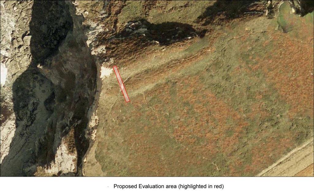
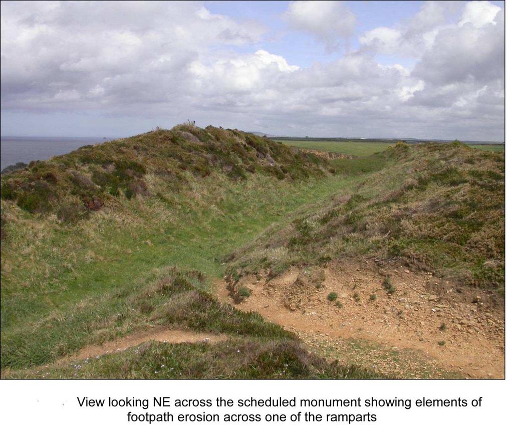
1 Unlocking Our Coastal Heritage Project: Crane Castle Promontory Fort, Illogan, Cornwall As part of a wider project funded by the Rural Development Programme for England (RDPE) and administered through DEFRA, the South West Coast Path team (SWCP) and the National Trust (NT), a number of archaeological sites have been selected in order to better conserve, enhance and manage them. The sites were chosen on the basis that they were on or adjacent to the South West Coast Path and that they are currently at risk of being irreparably damaged or lost, or could be made more accessible for wider audiences. This strand of the project (Strand 1) is entitled Unlocking our coastal heritage protecting the cultural corridor. The site of Crane Castle comprises the remains of a prehistoric promontory fort in the form of substantial upstanding remains of a double rampart. Almost the entire interior area has been destroyed through the erosion of the cliff face. Pedestrian erosion over parts of its surface has also eroded elements of this scheduled monument. It was selected so that that loss of this finite resource should be mitigated by survey of the area and targeted evaluation of an eroding section (followed by consolidation) which would in turn provide a valuable amount of information for both engagement and future management. The overall scheme of works proposed comprises a geophysical survey of the surrounding area, a topographical survey of the scheduled monument and immediate area and evaluation of a small area of the scheduled monument focussed on the area impacted by human and coastal erosion. The topographical survey and excavation elements which are the subject of this brief will consist of the topographical survey of the wider area in order to illustrate and understand its position in the landscape, and evaluation of a small section across the earthworks which will enable a clearer understanding of the monument before it is lost to coastal erosion. Overall the work will enable safe future public access and use of the site, a clearer understanding of the archaeological resource and allow for informed management and conservation recommendations in relation to the threatened site to be made. Crane Castle is located on the edge of a prominent coastal cliff known as Carvannel Downs, overlooking Basset's Cove, some 2500m south west of the Portreath near Illogan (SW ). Much of the area of


2 the monument itself is short coastal grassland, the marginal areas however are covered in bracken, gorse, brambles etc.
3
4 Archaeological Project Summary Crane Castle comprises the remains of a prehistoric promontory fort in the form of substantial upstanding remains of a double rampart. Almost the entire interior of the cliff castle has been destroyed through the erosion of the cliff face. Pedestrian erosion over areas of the upstanding ramparts has also eroded elements of this scheduled monument. Crane was selected for investigation so that the effects of the erosion could be measured against future loss. The overall scheme of archaeological works in comprised a geophysical survey of the surrounding area, a topographical survey of the scheduled monument and immediate area, and evaluation of a small area of the scheduled monument. The geophysical survey was undertaken by Archaeophysica with the remainder of the project being undertaken by Cornwall Historic Environment Service assisted by a group of very willing volunteers, including both experienced and inexperienced diggers. During the work participants were given training in the techniques of archaeological excavation and where time allowed, were given an introduction to site recording practices. The National Trust also organised a field trip by pupils from Illogan Primary School and Pool Academy, Camborne, who were given a talk on the excavations and helped excavate and sieve material from the spoil heap. An open day held on the last weekend of the evaluation gave passing walkers the chance to visit the excavated trench and learn about the project. The 2013 surveys and excavations represent the only systematic fieldwork carried out at the site and provided valuable information on the character and condition of the monument and the results are helping guide future management and wider interpretation. It is impossible to know exactly what the Crane Castle headland looked like prior to collapse into the sea. Crane Islands today certainly suggest that the tip was a rocky crag, probably some distance below the cliff. If it assumed that the cliff castle included what are now Crane Islands and that most of the cliff has been lost from the western side, this means the loss of approximately 5 hectares of land into the sea. The site has commanding views over the flat coastal plateau of Roskajeague Downs and North Cliffs and also out to sea, occupying a commanding position over Basset s Cove. The project has been a rare opportunity to investigate and record one of Cornwall s surviving cliff castles and successfully reveal the original ditch cuts and parts of rampart construction. Although dating evidence is limited to a single sherd of pottery, this is from an imported vessel
 and their intact deposits were far greater than anticipated with their implications for investment and greater complexity at their time of construction.")
5 indicating contact with the wider world and provides a date for activity at Crane Castle in the early Romano-British period, circa 100 AD. The considerable depths of both ditches (1.5 to 2.5m) and their intact deposits were far greater than anticipated with their implications for investment and greater complexity at their time of construction. Clear potential for further archaeological work should be considered in the future. This evaluation has also confirmed condition and the state of preservation of the monument and emphasises the need for monitoring of coastal erosion on sites such as this. The project also provided a valuable opportunity to engage a volunteer team on a unique site and train them in the techniques of archaeological excavation and also made the work accessible to local schools and the general public. Interpretative material based on the results of the evaluation exercise will enable the National Trust to update their documentation relating to the prehistoric and later use of this stretch of the Cornish coast.

6
CASTLE OF OLD WICK HISTORIC ENVIRONMENT SCOTLAND STATEMENT OF SIGNIFICANCE. Property in Care(PIC) ID: PIC282 Designations:
 ID: PIC282 Designations:") Property in Care(PIC) ID: PIC282 Designations: Scheduled Monument (SM90065) Taken into State care: 1957 (Guardianship) Last reviewed: 2004 HISTORIC ENVIRONMENT SCOTLAND STATEMENT OF SIGNIFICANCE CASTLE
Property in Care(PIC) ID: PIC282 Designations: Scheduled Monument (SM90065) Taken into State care: 1957 (Guardianship) Last reviewed: 2004 HISTORIC ENVIRONMENT SCOTLAND STATEMENT OF SIGNIFICANCE CASTLE
THE HEUGH LINDISFARNE
 LINDISFARNE COMMUNITY ARCHAEOLOGY THE HEUGH LINDISFARNE Archaeological excavations in June 2017 Invitation to volunteers THE HEUGH, LINDISFARNE, NORTHUMBERLAND: ARCHAEOLOGICAL EXCAVATIONS 2017 INTRODUCTION
Holyport Manor Special School, Highfield Lane, Cox Green, Maidenhead, Berkshire
 Holyport Manor Special School, Highfield Lane, Cox Green, Maidenhead, Berkshire An Archaeological recording action For CgMs Consulting by Jennifer Lowe Thames Valley Archaeological Services Ltd Site Code
Following the initial soil strip archaeology is sprayed up prior to planning and excavation
 Barton Quarry & Archaeology Over the past half century quarries have been increasingly highlighted as important sources of information for geologists, palaeontologists and archaeologists, both through
Cholesbury New House, Parrots Lane, Cholesbury, Buckinghamshire
 Cholesbury New House, Parrots Lane, Cholesbury, Buckinghamshire An Archaeological Watching Brief For Mr Martin Wood by Sean Wallis Thames Valley Archaeological Services Ltd Site Code PLC 06/135 March 2007
ROUKEN GLEN: BANDSTAND 2015 DATA STRUCTURE REPORT
 ROUKEN GLEN: BANDSTAND 2015 DATA STRUCTURE REPORT Author (s) Ian Hill Editors Report Date June 2015 Working Partners Funders Phil Richardson East Renfrewshire Council East Renfrewshire Council, Heritage
Wessex Archaeology. Little Stubbings, West Amesbury, Salisbury, Wiltshire. Archaeological Watching Brief. Ref:
 Wessex Archaeology Little Stubbings, West Amesbury, Salisbury, Wiltshire Ref: 63280.02 March 2007 LITTLE STUBBINGS, WEST AMESBURY, NR SALISBURY, WILTSHIRE ARCHAEOLOGICAL WATCHING BRIEF Prepared for: P
Land off Birdie Way, Rush Green, Hertford, Hertfordshire
 Land off Birdie Way, Rush Green, Hertford, Hertfordshire An Archaeological Evaluation for Bride Hall Development Limited by Sarah Coles Thames Valley Archaeological Services Site Code RGH00/ 01 January
Unlocking our Coastal Heritage Strand 2 - Watermouth Bay, nr Ilfracombe
 Unlocking our Coastal Heritage Strand 2 - Watermouth Bay, nr Ilfracombe In order to provide a safe route for users of the South West Coast Path this project realigned 265m of the A399 coast road to incorporate
Archaeological Investigations Project South East Region SOUTHAMPTON 2/842 (C.80.C004) SU
 SU") SOUTHAMPTON City of Southampton 2/842 (C.80.C004) SU 4382 1336 125 BITTERNE ROAD WEST, SOUTHAMPTON Report on the Archaeological Evaluation Excavation at 125 Bitterne Road West, Southampton Russel, A. D
SOUTHAMPTON City of Southampton 2/842 (C.80.C004) SU 4382 1336 125 BITTERNE ROAD WEST, SOUTHAMPTON Report on the Archaeological Evaluation Excavation at 125 Bitterne Road West, Southampton Russel, A. D
BRONZE AGE FIELD SYSTEM AT SOUTHAMPTON AIRPORT
 Proc. Hampshire Field Club Archaeol. Soc. 65, 2010, 1-6 (Hampshire Studies 2010) BRONZE AGE FIELD SYSTEM AT SOUTHAMPTON AIRPORT By J SULIKOWSKA With contributions by LORRAINE MEPHAM and CHRIS J STEVENS
Wilderness Research. in Alaska s National Parks. Scientists: Heading to the Alaska Wilderness? Introduction
 Wilderness Research in Alaska s National Parks National Park Service U.S. Department of Interior Scientists: Heading to the Alaska Wilderness? Archeologist conducts fieldwork in Gates of the Arctic National
The impact of investments & storms on the economic benefits provided by the South West Coast Path National Trail to the region between 2010 and 2014
 Cumulatve increase since 2010 The impact of investments & storms on the economic benefits provided by the South West Coast Path National Trail to the region between 2010 and 2014 Key findings Between 2010
Gorse Stacks, Bus Interchange Excavations Interim Note-01
 Gorse Stacks, Bus Interchange Excavations 2015 Prepared for: Cheshire West & Chester Council Interim Note-01 1 Introduction & Summary Background Since c. 2000 investigations associated with redevelopment
ANTONINE WALL - BARHILL
 Property in Care (PIC)no: PIC168 Designations: Scheduled Monument (SM90008) Taken into State care: 1960 (Guardianship) Last reviewed: 2005 HISTORIC ENVIRONMENT SCOTLAND STATEMENT OF SIGNIFICANCE ANTONINE
Working Towards Sustainable Tourism in England s AONBs
 Working Towards Sustainable Tourism in England s AONBs Purpose: this Accord sets out a shared vision for tourism in England s Areas of Outstanding Natural Beauty (AONBs) and outlines the contribution that
Archaeological Investigations Project Yorkshire & Humberside Region NORTH YORKSHIRE 2/1113 (C.36.J002) SD
 SD") NORTH YORKSHIRE Craven 2/1113 (C.36.J002) SD 93607800 CRAY BECK, BUCKDEN, UPPER WHARFEDALE Cray Beck, The Archaeological Investigation of a Stone Feature Archetype Wensleydale : ArcheType Archaeological
NORTH YORKSHIRE Craven 2/1113 (C.36.J002) SD 93607800 CRAY BECK, BUCKDEN, UPPER WHARFEDALE Cray Beck, The Archaeological Investigation of a Stone Feature Archetype Wensleydale : ArcheType Archaeological
CAS Case Study: Mullion Harbour, adapting to a stormier future
 t The National Trust Coastal Adaptation Strategy Case Study: Mullion Harbour Authors: Ed Bartlett, Alastair Cameron, Phil Dyke & Adrian Woodhall June 2010 CAS Case Study: Mullion Harbour, adapting to a
A21 TONBRIDGE TO PEMBURY DUALLING. Statement of Case
 A21 TONBRIDGE TO PEMBURY DUALLING Statement of Case In Respect of Applications for the Demolition of Listed Buildings Under the Provisions of the Planning (Listed Buildings and Conservation Areas) Act
Living & Working Access and Recreation
 Living & Working Access and Recreation 5.9 Access and Recreation Background 5.9.1 The countryside has increasingly become a popular destination for visitors and an important resource for informal recreation.
An archaeological excavation at 193 High Street, Kelvedon, Essex September 2009
 An archaeological excavation at 193 High Street, Kelvedon, Essex September 2009 report prepared by Ben Holloway and Howard Brooks on behalf of Marden Homes CAT project ref.: 09/4g NGR: TL 8631 1913 (c)
FOUNDATIONS OF ARCHAEOLOGY A WALK IN VERNDITCH CHASE
 FOUNDATIONS OF ARCHAEOLOGY A WALK IN VERNDITCH CHASE 1. A Tale of two Long Barrows Long barrows were constructed as earthen or drystone mounds with flanking ditches and acted as funerary monuments during
HILL-FORTS OF THE INNER TAY ESTUARY PERTH. Phase One PERTH AND KINROSS. Archaeological Survey Report. Oxford Archaeology North.
 HILL-FORTS OF THE INNER TAY ESTUARY PERTH PERTH AND KINROSS Phase One Archaeological Survey Report Oxford Archaeology North September 2012 Issue No: 2012-13/11322 OAN Job No: L10492a NGR: NO 182 153, NO
East Midlands Region LEICESTER 3/16 (E.62.A010) SK
 SK") LEICESTER City of Leicester 3/16 (E.62.A010) SK 5853 0433 12 NEW ST., CASTLE WARD, LEICESTER Cottage to the Rear of 12 New St., Castle Ward, Leicester - A Photographic Survey and Archaeological Watching
LEICESTER City of Leicester 3/16 (E.62.A010) SK 5853 0433 12 NEW ST., CASTLE WARD, LEICESTER Cottage to the Rear of 12 New St., Castle Ward, Leicester - A Photographic Survey and Archaeological Watching
Henderson Mess, RAF Halton, Buckinghamshire
 Henderson Mess, RAF Halton, Buckinghamshire An archaeological watching brief for Stepnell Ltd by Stephen Hammond Thames Valley Archaeological Services Ltd Site Code RHA03/85 October 2003 Summary Site name:
HUT POINT, ROSS ISLAND
 Measure 2 (2005) Annex K Management Plan for Antarctic Specially Protected Area No. 158 HUT POINT, ROSS ISLAND (including Historic Site and Monument No. 18, the historic Discovery hut of Captain R F Scott)
Chiselbury Camp hillfort
 Chiselbury Camp hillfort Reasons for Designation Large univallate hillforts are defined as fortified enclosures of varying shape, ranging in size between 1ha and 10ha, located on hilltops and surrounded
Report on an archaeological watching brief at Thomas Lord Audley School, Monkwick, Colchester
 Report on an archaeological watching brief at Thomas Lord Audley School, Monkwick, Colchester July 2000 for WS Atkins Property Services Colchester Archaeological Trust 12 Lexden Road, Colchester, Essex
RURAL LAND RESOURCES Case study area 1- the erosional features of the Dorset Coast.
 Case study area 1- the erosional features of the Dorset Coast. Scene setting;- This area lies on the far south coast of England, between the settlements of Lyme Regis and Bournemouth, in the county of
ANTONINE WALL - DULLATUR
 Property in Care (PIC) ID: PIC172 Designations: Scheduled Monument (SM90017); Taken into State care: 1960 (Guardianship) Last reviewed: 2018 HISTORIC ENVIRONMENT SCOTLAND STATEMENT OF SIGNIFICANCE ANTONINE
Pen Cerrig-calch prehistoric cairns
 Walk Information: Maps: OS Explorer OL13 Distance: 8 miles / 13 kilometres Duration: Allow at least 6 hours for the circular walk Difficulty: medium. Some narrow paths, occasionally rough underfoot Start
Scheduled Monument (SM90085) Taken into State care: 1966 (Guardianship) Last reviewed: 2004 CROOKSTON CASTLE
 Taken into State care: 1966 (Guardianship) Last reviewed: 2004 CROOKSTON CASTLE") Property in Care (PIC) ID: PIC119 Designations: Scheduled Monument (SM90085) Taken into State care: 1966 (Guardianship) Last reviewed: 2004 HISTORIC ENVIRONMENT SCOTLAND STATEMENT OF SIGNIFICANCE CROOKSTON
Property in Care (PIC) ID: PIC119 Designations: Scheduled Monument (SM90085) Taken into State care: 1966 (Guardianship) Last reviewed: 2004 HISTORIC ENVIRONMENT SCOTLAND STATEMENT OF SIGNIFICANCE CROOKSTON
GESELLSCHAFT ZUR FÖRDERUNG VON MUSEEN IN ÄTHIOPIEN E.V. (GFMÄ)
") GESELLSCHAFT ZUR FÖRDERUNG VON MUSEEN IN ÄTHIOPIEN E.V. (GFMÄ) REPORT ON ARCHAEOLOGICAL FIELD TRIP TO ETHIOPIA 10th-20th OCTOBER 2016 Ethiopian-German Expedition to Wuqro Deutschen Archäologischen Instituts
GESELLSCHAFT ZUR FÖRDERUNG VON MUSEEN IN ÄTHIOPIEN E.V. (GFMÄ) REPORT ON ARCHAEOLOGICAL FIELD TRIP TO ETHIOPIA 10th-20th OCTOBER 2016 Ethiopian-German Expedition to Wuqro Deutschen Archäologischen Instituts
St Kilda Archaeologist s Annual Report 2005
 St Kilda Archaeologist s Annual Report 2005 cleit in Gleann Mor CONTENTS 1.0 Executive Summary 2.0 Introduction 3.0 The 2004/2005 Winter Season 4.0 The 2005 Summer Season 5.0 The 2005/2006 Winter Season
An archaeological evaluation at 14 Vineyard Street, Colchester, Essex March 2006
 An archaeological evaluation at 14 Vineyard Street, Colchester, Essex March 2006 report prepared by Ben Holloway commissioned by Colchester Borough Council CAT project code: 06/4b Colchester Museums accession
An archaeological excavation and watching brief at the Musket Club, Homefield Road, Colchester, Essex December 2004-February 2005
 An archaeological excavation and watching brief at the Musket Club, Homefield Road, Colchester, Essex December 2004-February 2005 report prepared by Howard Brooks on behalf of RMPA and the MoD CAT project
Greater London Region GREATER LONDON 1/204 (B.01.A131) TQ
 TQ") GREATER LONDON City of Westminster 1/204 (B.01.A131) TQ 2911 8076 10-13 OLD BURLINGTON STREET, 19 CLIFFORD STREET AND 30-32 SAVILE ROW 10-13 Old Burlington Street, 19 Clifford Street and 30-32 Savile Row,
GREATER LONDON City of Westminster 1/204 (B.01.A131) TQ 2911 8076 10-13 OLD BURLINGTON STREET, 19 CLIFFORD STREET AND 30-32 SAVILE ROW 10-13 Old Burlington Street, 19 Clifford Street and 30-32 Savile Row,
Just under a mile from Cawfields car park where the walk begins is Great Chesters Roman Fort. It is behind the tree, looking from the west.
 Tynedale U3A Hadrian s Wall Group Cawfields to Birdoswald Just under a mile from Cawfields car park where the walk begins is Great Chesters Roman Fort. It is behind the tree, looking from the west. Great
Investigations at Jackdaw Crag Field, Boston Spa, SE , in by Boston Spa Archaeology and Heritage Group
 0 Investigations at Jackdaw Crag Field, Boston Spa, SE 42304632, in 2006-7 by Boston Spa Archaeology and Heritage Group www.bostonspaheritage.co.uk Preface and Summary This report records the results of
The Tel Burna Archaeological Project Report on the First Season of Excavation, 2010
 The Tel Burna Archaeological Project Report on the First Season of Excavation, 2010 By Itzick Shai and Joe Uziel Albright Institute for Archaeological Research Jerusalem, Israel April 2011 The site of
Archaeological Monitoring at Ham Farm, Ham Road, Faversham, Kent
 Archaeological Monitoring at Ham Farm, Ham Road, Faversham, Kent NGR: 601750.0mE 162695.0mN Site Code HAM/WB/12 Report for A.J. Bray SWAT ARCHAEOLOGY Swale and Thames Archaeological Survey Company The
Stobs Camp Project Quarter 1 Report April June 2018
 Stobs Camp Project Quarter 1 Report April June 2018 Executive Summary During this period the project ran an excavation at two fortification practice trenches. Adult volunteers and school pupils were able
E&M West Buildings Union Street, Aberdeen, AB10 1GD
 E&M West Buildings 32-38 Union Street, Aberdeen, AB10 1GD 30 November 2011 E&M West Buildings 32-38 Union Street, Aberdeen, AB10 1GD CONTENTS 1 INTRODUCTION 3 2 ARCHAEOLOGICAL BACKGROUND 4 3 THE WATCHING
An archaeological watching brief on land adjacent to 50 Rosebery Avenue, Colchester, Essex May/June 2003
 An archaeological watching brief on land adjacent to 50 Rosebery Avenue, Colchester, Essex May/June 2003 report prepared by C Crossan on behalf of Highfield Homes Ltd NGR: TM 0035 2500 CAT project ref.:
Eglwyseg Mountain a landscape of prehistoric cairns and later industry
 Eglwyseg Mountain a landscape of prehistoric cairns and later industry Walk Information: Maps: OS Explorer 256 Distance: 5.3 miles / 8.5 kilometres (linear) or up to 9.6 miles / 15.5 kilometres (circular)
4. Bronze Age Ballybrowney, County Cork Eamonn Cotter
 4. Bronze Age Ballybrowney, County Cork Eamonn Cotter Illus. 1 Location map of the excavated features at Ballybrowney Lower (Archaeological Consultancy Services Ltd, based on the Ordnance Survey Ireland
Fieldwork Report for the Society for the Promotion of Roman Studies
 Fieldwork Report for the Society for the Promotion of Roman Studies A geophysical survey of the Roman villa at Santa Maria della Strada Matrice (Campobasso, Italy) Paul Roberts ¹, Dominic Rathbone ², Stephen
CARLUNGIE EARTH HOUSE
 Property in Care (PIC) ID: PIC015 Designations: Scheduled Monument (SM90059) Taken into State care: 1953 (Guardianship) Last reviewed: 2004 HISTORIC ENVIRONMENT SCOTLAND STATEMENT OF SIGNIFICANCE CARLUNGIE
Stainforth & Keadby Canal Installation of Multiuser Path
 Stainforth & Keadby Canal Installation of Multiuser Path Introduction North Lincolnshire Council has entered into an agreement with Canal & River Trust to develop proposals to introduce a multiuser path
Coast Path Survey Stretch 09 Shalfleet Mill to Thorness Bay
 Coast Path Survey Stretch 09 Shalfleet Mill to Thorness Bay Overview Map of stretch Introduction This stretch of Island coast covers several salt marsh creeks backed by grazing land and woodland on the
Monitoring Report No. 278
 Roe Valley Country Park Hydroelectric Restoration Scheme Roe Valley Country Park Largy townland County Derry AE/14/30 Ruth Logue Site Specific Information Site location: Roe Valley Country Park, 41 Dogleap
FORMER COUNTY OF SOUTH YORKSHIRE
 FORMER COUNTY OF SOUTH YORKSHIRE Barnsley 3/1883 (E.04.6010) SE 36491121 4 CHURCH HILL, ROYSTON 4 Church Hill, Royston, South Yorkshire. Archaeological Watching Brief (Report No. 868) O'Neill, R Leeds
Coast Survey Stretch 07 Freshwater Bay LBS to Yarmouth Bridge
 Coast Survey Stretch 07 Freshwater Bay LBS to Yarmouth Bridge Overview map of the stretch Introduction This section includes Headon Warren and West High Down SSSI, Colwell Bay SSSI and part of Yar Estuary.
Long Cairn Divis County Antrim
 Survey Report No. 66 Harry Welsh Long Cairn Divis County Antrim 2 Ulster Archaeological Society 2018 Ulster Archaeological Society c/o School of Natural and Built Environment Queen s University Belfast
Wheatlands House, Fleet Hill, Finchampstead, Berkshire
 Wheatlands House, Fleet Hill, Finchampstead, Berkshire An Archaeological Watching Brief For JCA International by James McNicoll-Norbury Thames Valley Archaeological Services Ltd Site Code WFF 08/26 August
The EXPLORERS CLUB. Report of Expedition. Xlendi Project Season Supported By AURORA TRUST and HERITAGE MALTA FLAG # 97
 The EXPLORERS CLUB Report of Expedition FLAG # 97 Xlendi Project 2007 Season Supported By AURORA TRUST and HERITAGE MALTA Craig Mullen Ian G. Koblick Introduction Explorer s Club Flag number 97 was issued
Wanaka Community Board 15 April Report for Agenda Item: 4
 Wanaka Community Board 15 April 2015 Department: Infrastructure Report for Agenda Item: 4 Mt Burke Station Stopping and Vesting of Road Purpose 1 To obtain the Board s support for a stakeholder agreement
ARCHAEOLOGICAL S E R V I C E S. Phase 5, Grimsby Road, Cippenham, Slough, Berkshire. Archaeological Recording Action.
 T H A M E S V A L L E Y ARCHAEOLOGICAL S E R V I C E S Phase 5, Grimsby Road, Cippenham, Slough, Berkshire Archaeological Recording Action by Andy Taylor Site Code: GRC13/57 (SU 9493 7977) Phase 5, Eltham
Oswestry Castle Research Project
 Oswestry Castle Research Project A Design Specification for an Archaeological Excavation at Oswestry Castle Site: Oswestry Castle, Shropshire. Landowner: Oswestry Town Council, Shropshire NGR: SJ 29051
Strategy - The Big Picture
 Appendix 1 Strategy - The Big Picture Cameron House Balloch Castle Maid of the Loch and Watersports Hub Loch Lomond Shores Walled Garden Development Site East Riverside Path West riverside Walk Moss O
TH E FIRST SEASON of investigations at the
 QUSEIR AL-QADIM Janet H. Johnson & Donald Whitcomb TH E FIRST SEASON of investigations at the ancient port of Quseir al-qadim on the Red Sea in Egypt took place in winter, 1978; the investigations were
CHRISTCHURCH MOTORWAYS. Project Summary Statement February 2010
 CHRISTCHURCH MOTORWAYS Project Summary Statement February 2010 Table of Contents 1. Purpose of Document 2. Strategic Context 3. Benefits 4. Project Scope and Economics 5. Implementation Plan 1 ROADS OF
Northamptonshire Archaeology
 Northamptonshire Archaeology A programme of archaeological observation, investigation and recording at St Andrews Church, Spratton, Northamptonshire Northamptonshire Archaeology 2 Bolton House Wootton
DEFENCE AREA 73 FRESHWATER BAY
 DEFENCE AREA 73 FRESHWATER BAY 1. Area details: The defence area is 3½ miles from The Needles and 10 miles W of Newport. County: Isle of Wight. Parish: Freshwater. NGR: centre of area, SZ 346860. 1.1 Area
S E R V I C E S. Land to the rear of Ashdown, Basingstoke Road, Spencers Wood, Reading, Berkshire. Archaeological Evaluation.
 T H A M E S V A L L E Y ARCHAEOLOGICAL S E R V I C E S Land to the rear of Ashdown, Basingstoke Road, Spencers Wood, Reading, Berkshire Archaeological Evaluation by Susan Porter Site Code: ASW12/21 (SU
IKLAINA ARCHAEOLOGICAL PROJECT 2012 FIELD REPORT
 IKLAINA ARCHAEOLOGICAL PROJECT 2012 FIELD REPORT Michael B. Cosmopoulos The sixth season of the Iklaina Archaeological Project was conducted for six weeks in June and July 2012. Τhe project is conducted
Excavations in a Medieval Market Town: Mountsorrel, Leicestershire,
 Excavations in a Medieval Market Town: Mountsorrel, Leicestershire, by John Lucas Mountsorrel is situated 12 kms north of Leicester and forms a linear settlement straddling the A6, Leicester to Derby road.
South West Region GLOUCESTERSHIRE 1/405 (B.23.H005) SU
 SU") GLOUCESTERSHIRE Cotswold 1/405 (B.23.H005) SU 16559880 COTSWOLD EASTERN SPINE ROAD STAGE 4 Cotswold Eastern Spine Road Stage 4 and Horcott Road. Watkins, K Gloucester : Gloucestershire County Council Archaeology
GLOUCESTERSHIRE Cotswold 1/405 (B.23.H005) SU 16559880 COTSWOLD EASTERN SPINE ROAD STAGE 4 Cotswold Eastern Spine Road Stage 4 and Horcott Road. Watkins, K Gloucester : Gloucestershire County Council Archaeology
Monitoring Report No. 227
 City of Derry Airport Longfield More townland Eglinton County Derry AE/10/61 Ruth Logue Site Specific Information Site location: City of Derry Airport, Airport Road, Eglinton, BT47 3GY Townland: Longfield
Economic Development Sub- Committee
 Report title: Economic Development Sub- Committee Item No. Date of meeting: 24 November 2016 A47 Road Investment Strategy - update Responsible Chief Tom McCabe Executive Director, Community Officer: and
Channel Islands Occupation Society
 INTRODUCTION The subject of the Conservation Statement is Kempt Tower, built in 1834 in St Ouen s Bay, Jersey. The primary purpose of the statement is to draw together existing information, to set down
ARDESTIE EARTH HOUSE HISTORIC ENVIRONMENT SCOTLAND STATEMENT OF SIGNIFICANCE. Property in Care no: 24
 Property in Care no: 24 Designations: Scheduled Monument (SM90021) Taken into State care: 1953 (Guardianship) Last reviewed: 2004 HISTORIC ENVIRONMENT SCOTLAND STATEMENT OF SIGNIFICANCE ARDESTIE EARTH
Better Towpaths for Everyone. A national policy for sharing towpaths
 Better Towpaths for Everyone A national policy for sharing towpaths Contents Foreword 2 Introduction 3 Consultation 3 Principles of towpath use 4 Better infrastructure 5 Towpath Design Guide 5 Better signs
Please see our website for up to date contact information, and further advice.
 Saxon Shore Forts On 1st April 2015 the Historic Buildings and Monuments Commission for England changed its common name from English Heritage to Historic England. We are now re-branding all our documents.
158 HUT POINT, ROSS ISLAND
 Measure 13 (2015) Management Plan For Antarctic Specially Protected Area No. 158 HUT POINT, ROSS ISLAND (including Historic Site and Monument No. 18, the historic Discovery hut of Captain Robert Falcon
The Roman Rural Settlement Project
 The Roman Rural Settlement Project Preliminary results from the East Midlands Dr Tom Brindle Crown Copyright/database right 2013. The East Midlands dataset 544 records of LIA/Roman sites 15% of Jeremy
Open Report on behalf of Richard Wills, Executive Director for Environment and Economy
 Agenda Item 7 Executive Open Report on behalf of Richard Wills, Executive Director for Environment and Economy Report to: Executive Date: 02 September 2014 Subject: Lincoln East West Link Road Phase 1
Research Briefing Flood and Coastal Erosion Risk Management in Wales
 Research Briefing Flood and Coastal Erosion Risk Management in Wales Author: Wendy Dodds Date: September 2017 National Assembly for Wales Research Service The National Assembly for Wales is the democratically
The tourism value of the natural environment and outdoor activities in
 The tourism value of the natural environment and outdoor activities in the South West Produced on behalf of the South West Coast Path Association By The South West Research Company Ltd January 2016 1 Contents
Wimpole Estate Multi-use Trail 2017 Frequently asked questions
 Wimpole Estate Multi-use Trail 2017 Frequently asked questions Why does the National Trust want to create new trails? We want to play our part in helping to reconnect the nation with the outdoors. At the
Non-technical summary
 Introduction NTS1 NTS2 NTS3 Troika Developments Ltd (Troika) has submitted a planning application to Bournemouth Borough Council (BBC) for an extension of time to implement planning permission 7/2004/16450/G,
Final Design Approval of the Weather Shelters and Summit Stair for the Mount Umunhum Summit Project
 R-16-26 Meeting 16-06 March 9, 2016 AGENDA ITEM AGENDA ITEM 6 Final Design Approval of the Weather Shelters and Summit Stair for the Mount Umunhum Summit Project GENERAL MANAGER S RECOMMENDATIONS 1. Direct
Department for Transport
 Department for Transport Louise Ellman MP Chair, Transport Select Committee House of Commons London SW1AOAA From the Minister of State The Rt. Hon. John Hayes CBE MP Great Minster House 33 Horseferry Road
INFORMATION NOTICE 15-2 Limited & Excluded Lands
 INFORMATION NOTICE 15-2 Limited & Excluded Lands Schedule 1 (Land Description) of onshore petroleum Agreements issued by the Department of Energy details the total hectares calculated. Total hectares are
The Atlas of Hillforts of Britain and Ireland. Hillfort survey notes for guidance
 The Atlas of Hillforts of Britain and Ireland Hillfort survey notes for guidance The collection of surveys for the Atlas is now finished but you can use this form and the accompanying Notes for Guidance
ROCHESTER RIVERSIDE. City of learning, culture, tourism and enterprise.
 ROCHESTER RIVERSIDE City of learning, culture, tourism and enterprise www.medway.gov.uk/medwayrenaissance www.medwayrenaissance.com CAT RIVER MEDWAY 15 11 21 16 13 17 14 18 20 19 CASTLE 12 Y 1 6 4 3 2
THRESHOLD GUIDELINES FOR AVALANCHE SAFETY MEASURES
 BRITISH COLUMBIA MINISTRY OF TRANSPORTATION & INFRASTRUCTURE AVALANCHE & WEATHER PROGRAMS THRESHOLD GUIDELINES FOR AVALANCHE SAFETY MEASURES British Columbia Ministry of Transportation & Infrastructure
Remote Sensing into the Study of Ancient Beiting City in North-Western China
 Dingwall, L., S. Exon, V. Gaffney, S. Laflin and M. van Leusen (eds.) 1999. Archaeology in the Age of the Internet. CAA97. Computer Applications and Quantitative Methods in Archaeology. Proceedings of
Specification for Grip blocking using Peat Dams
 Technical Guidance Note 1 Specification for Grip blocking using Peat Dams 1. Introduction Moorland drains (grips) have been dug across much of the Yorkshire upland peatlands. Many of these grips have become
Annual Report & Accounts for 2016
 Charity XT29402 Annual Report & Accounts for 2016 SOAG 48th ANNUAL GENERAL MEETING Goring Heath Parish Hall, Whitchurch Hill 2:00pm on Sunday 23rd April 2017 (Clockwise from top left) While some messed
Revision: Date: Prepared by: Checked by: Approved by: Reason for Issue: Nick Elsden (MOLA) Nick Elsden (MOLA) Page 2
 Nick Elsden (MOLA) Page 2") This document contains proprietary information. No part of this document may be reproduced without prior written consent from the chief executive of Crossrail Ltd. Revision: Date: Prepared by: Checked
This document contains proprietary information. No part of this document may be reproduced without prior written consent from the chief executive of Crossrail Ltd. Revision: Date: Prepared by: Checked
South East SOUTHAMPTON
 Southampton SOUTHAMPTON 3/1056 (E.80.M010) SU 44181114 SO19 7PE 1 FOREST VIEW, SOUTHAMPTON Report on the Archaeological Watching Brief at 1 Forest View, Southampton, SOU 1232 Leivers, M Southampton : Southampton
Manor Farm, Wilcot, Pewsey, Wiltshire
 Manor Farm, Wilcot, Pewsey, Wiltshire An Archaeological Evaluation for Mr W. Madiment by Helen Moore Thames Valley Archaeological Services Ltd Site Code MFP02/78 September 2002 Summary Site name: Manor
Living & Working Tourism
 Living & Working Tourism 5.10Tourism Background 5.10.1 Tourism is a major rural industry in Dorset, contributing over 600 million in visitor expenditure and supporting over 21,000 jobs directly and indirectly
ANNUAL REPORT: ANCIENT METHONE ARCHAEOLOGICAL PROJECT 2014 FIELD SCHOOL
 ANNUAL REPORT: ANCIENT METHONE ARCHAEOLOGICAL PROJECT 2014 FIELD SCHOOL Director(s): Co- Director(s): Professor Sarah Morris, Cotsen Institute of Archaeology, UCLA John K. Papadopoulos, Cotsen Institute
IOW Ramblers Submission Paper to the Sept 2016 ROW Improvement Plan Consultation.
 IOW Ramblers Submission Paper to the Sept 2016 ROW Improvement Plan Consultation. The current Island Rights of Way Improvement Plan is a comprehensive document and much of its content is still relevant
Chapter 12 Route window W15 Dog Kennel bridge. Transport for London
 Chapter 12 Route window W15 DOG KENNEL BRIDGE 12 Route window W15 12.6 southwards to North Park Road and Richings Park Golf Course. To the west side of this route window is the built-up edge of Slough
Friends of Ayton Castle Meeting Minutes 8th October2018 Present Catherine Cussons (Farmer), Paul Buck (Scarborough Borough Council), Peter Durkin
, Paul Buck (Scarborough Borough Council), Peter Durkin") Friends of Ayton Castle Meeting Minutes 8th October2018 Present Catherine Cussons (Farmer), Paul Buck (Scarborough Borough Council), Peter Durkin (local resident), John Edwards (local resident), Jean Glover
Friends of Ayton Castle Meeting Minutes 8th October2018 Present Catherine Cussons (Farmer), Paul Buck (Scarborough Borough Council), Peter Durkin (local resident), John Edwards (local resident), Jean Glover
A303 Stonehenge Amesbury to Berwick Down
 A303 Stonehenge Amesbury to Berwick Down The case for the scheme Contents The A303 Corridor 4 Amesbury to Berwick Down 5 The case for the scheme 5 Map of the area 6 Objective 1: Transport 7 Objective 2:
BACKCOUNTRY TRAIL FLOOD REHABILITATION PROGRAM
 BACKCOUNTRY TRAIL FLOOD REHABILITATION PROGRAM Backcountry Trail Flood Rehabilitation A June 2013 Flood Recovery Program Summary In June 2013, parts of Southern Alberta were devastated from significant