Stainforth & Keadby Canal Installation of Multiuser Path
|
|
|
- Martha Knight
- 5 years ago
- Views:
Transcription


1 Stainforth & Keadby Canal Installation of Multiuser Path


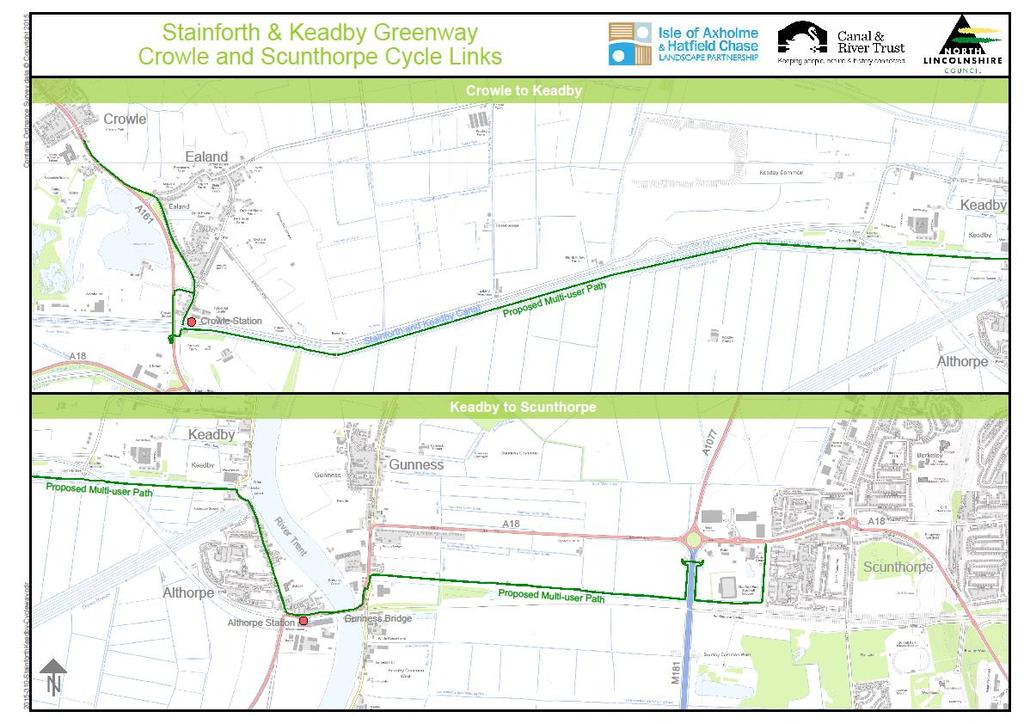
2 Introduction North Lincolnshire Council has entered into an agreement with Canal & River Trust to develop proposals to introduce a multiuser path along the Stainforth & Keadby Canal as part of a 500,000 scheme to link Crowle to Scunthorpe. The towpath improvements will provide new, sustainable routes to employment for the residents of the Isle of Axholme within the North Lincolnshire area. It will also increase the number of people accessing the Isle for health and leisure, and thus the opportunities for employment and business growth and economic impact in this area. This scheme will also provide employment for people from the local area. The Stainforth & Keadby Canal is a beautiful area with limited access for pedestrians, cyclists, anglers and especially the disabled, particularly after rain. The towpath improvements will reduce the antisocial use of this area by illegal off-road vehicles, by generating more positive use and will bring long-term benefits to the area for generations to come, encouraging visitors to North Lincolnshire from the neighbouring boroughs. It will provide an opportunity, through the use of interpretation boards, to divest information on the areas outstanding natural and built heritage, including the industrial legacy of the canal, rail and power generation including the fascinating bridge, and provide opportunities for people to become involved with the Canal & River Trust s charitable activities.

3 This project is part of a larger scheme to deliver a multi-user path between Crowle and Scunthorpe along existing public rights of way. Our project will be to improve the canal towpath and the conne ctions to the public rights of way, for 5km between Keadby Swing Bridge and the A161 road bridge in Crowle. In addition to the towpath improvements we will improve access for disabled anglers where required and improve the biodiversity of the waterway by installing deer ramps (access/egress for deer that have been known to fall into the waterway) and habitat improvements for wildlife such as coir rolls, bat boxes and owl boxes where possible. The scheme will be split in to 12 Phases for construction purposes, with Phase 2-6 covering the 5km length of the S&K Canal between Crowle and Keadby. It will provide a route on which walking and cycling can take place. Anglers will be catered for with a newly mown route and parking areas. Licenced anglers will be accommodated with access through a locked gate to ensure fishing is regulated and to deter inappropriate vehicle access.


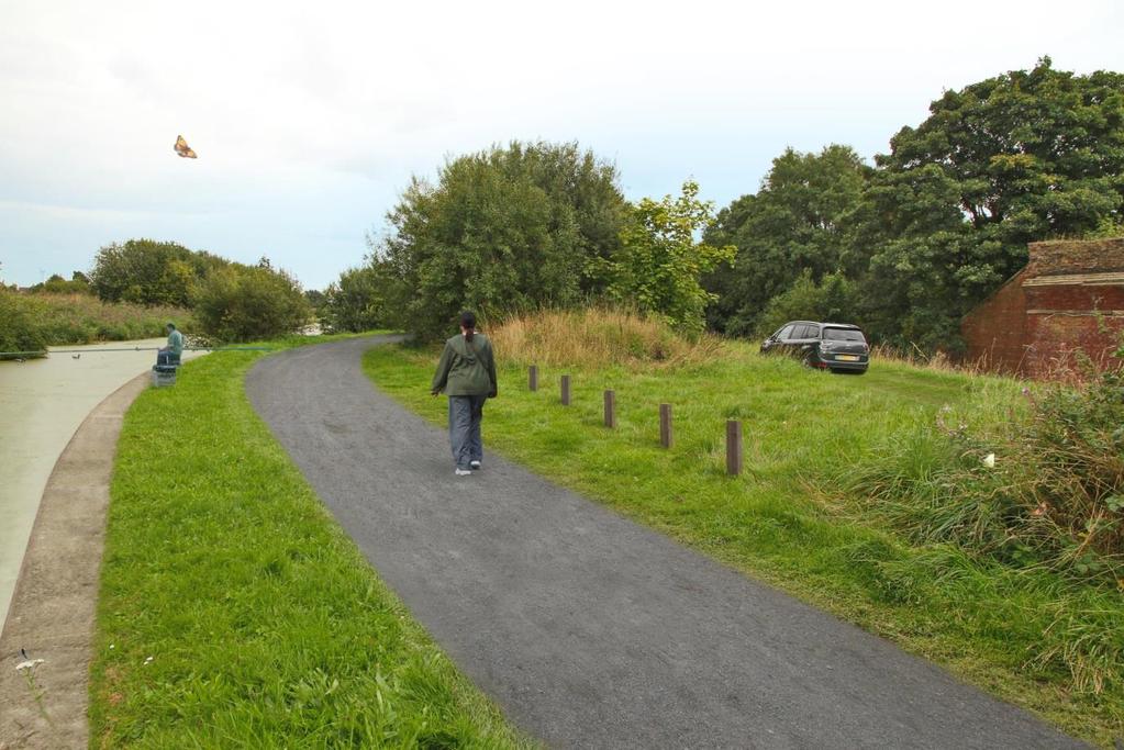
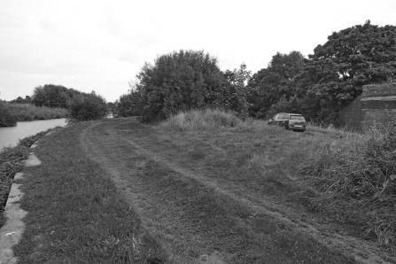
4 Part of the path will be installed on the south side of the canal currently overgrown and almost inaccessible along the Keadby section; with the Crowle section deeply rutted and muddy with extensive evidence of four-wheel-drive use, making it almost inaccessible on foot or by bicycle. The current towpath is grass, with very little evidence of any original hard material. It is entirely possible that historically there was no hard surfaced towpath along this section. This has led to it being very muddy and rutted, even during summer. Evidence from local residents suggests that it is currently regularly accessed by four-wheel-drive vehicles, and it is unlikely that this is for angling purposes, more likely being those who use this as a recreational route. This is causing considerable damage to the area between the canal and the drain, as can be seen in the photographs taken in late summer. It is likely this situation becomes far worse over the winter making the route impassable on foot or by bicycle. Although the route passes several residential and employment areas, very few people have been seen using the area on foot, and no cyclists have been seen during regular site visits over the summer. This would suggest that those living near the area are either deterred from using this route, partly as a result of the conditions along the canal bank.
5 To eliminate through traffic, but allow anglers to bring their vehicles closer to where they will be fishing, two solutions are proposed. At the point where the New Pilfrey Bridge crosses the drains and the canal, the intention is to restrict this point so no motor vehicle can pass here. A 2m wide towpath will pass at the point of the concrete bridge footings, restricted by a central bollard. Along the length of the canal bank, the proposal is to create a 300mm high grass bank to delineate the towpath (where no vehicles will be allowed) from the drain bank (where anglers vehicles will be allowed).
6 The Trust have developed several policy documents designed to improve the way towpath schemes are implemented, the key document being Better Towpaths for Everyone. As well as setting out nine simple principles of towpath use, the policy identifies three key areas of focus: Better Infrastructure we have secured investment of 15m to widen and resurface towpaths over the past two years and will continue to use external sources of funding to carry out similar schemes across the network. Additionally consideration of lighting and access/barriers will be added to the Trust s existing towpath design guidance. Better Signs clear and prominent shared-use signs will be installed across the country where there are concerns raised by local stakeholders and customers. These are designed to encourage safer sharing such as at blind spots, pinch points and on busier towpath stretches, where there may also be moored boats. Better Behaviour a range of initiatives to encourage considerate use of towpaths will be developed. The Share the Space, Drop your Pace campaign and towpath code which have been successful in London will be extended to other parts of the network and, where needed, we will look at other methods to promote safe behaviour such as downloadable materials and volunteer towpath rangers. The policy also includes a new Towpath Code based around the three elements Share the Space, Drop Your Pace, and It s a Special Place to reflect the unique character of the canalside environment. The promotion of public health is becoming an ever more important aspect of policy across local and national government. It is widely acknowledged that fostering a physically and mentally healthy population leads to higher levels of both labour force participation and productivity, whilst also reducing health service and welfare costs. Whilst there are many aspects of health promotion, the availability of high quality greenspace has assumed increasing importance in recent years. Greenspace can act as a multi-functional health asset, encouraging people to take more exercise, providing a peaceful environment
7 and offering a real alternative to undertaking journeys by the private car in some places. A recent paper (Measuring the Health Impacts of Scotland s Canals) has set out the positive health impacts of Scotland s Lowland Canal network. The wide ranging analysis undertaken in the study area focused on a 70 mile linear corridor has established that the canals generate health benefits in terms of increased physical activity; safety; air quality; and social and community cohesion. In quantitative terms, the canals deliver: almost 3.9 million additional person kilometres of travel per annum, equating to a physical health benefit of 6.4 million per annum; the towpaths remove over 1 million cycle kilometres from the roads, with an annual safety benefit of 220k; additional physical activity on the canal leads to a 77k direct reduction in employer costs through reduced absenteeism. There are also wider, but as yet unquantifiable benefits, in terms of increased productivity. The canals reduce exposure to poor air quality by almost 85,000 hours per annum; The project will provide new low carbon routes to employment, related health benefits and leisure routes between the communities of the Isle of Axholme and Scunthorpe. This project is part of a longer-term aspiration to improve the towpath and public rights of way linkages all the way to Doncaster where the Stainforth & Keadby meets the New Junction Canal in Stainforth. North Lincolnshire has seen a sustained and significant decline in serious road injuries and deaths; however cyclist injuries continue to be stubbornly high, cyclists becoming significantly more at risk on high-speed rural roads. Giving cyclists an alternative traffic-free route on which to travel for these parts of their journeys will significantly reduce their chances of being involved in a lifechanging road traffic collision.


8 Cyclists involved in Road Traffic Collisions in North Lincolnshire Year Cyclist Killed or Serious Cyclist Slight Injury The finished route will be constructed at 175mm depth and 2.1m width, and finished with local blast furnace slag dust. A large grass area will be retained adjacent to the water, and this will be available for anglers to fish from. The photographs below are from the River Ancholme, where a similar scheme has been undertaken. The scheme will also see habitat improvement for water voles and the installation of bat boxes and owl boxes. The C&RT have a very limited budget to work with annually, with most of the money targeted towards maintenance of the waterways, locks etc. This work therefore represents a significant investment in the C&RT infrastructure with the aim of improving the health and wellbeing of the local population. Work is programmed to start towards the end of the year, and it will be necessary to close sections of the path for safety reasons during construction.
9 Work on the canal bank is expected to take 4 months, with completion scheduled for Easter Consultation will be undertaken through local Parish Councils, on the Canal & River Trust website and the North Lincolnshire Council website until 16 November If you would like to comment on these proposals, please ProjectYHP327@northlincs.gov.uk or write to: Project YHP327 The Environment Team North Lincolnshire Council Church Square House Scunthorpe DN15 6XQ
10
Better Towpaths for Everyone. A national policy for sharing towpaths
 Better Towpaths for Everyone A national policy for sharing towpaths Contents Foreword 2 Introduction 3 Consultation 3 Principles of towpath use 4 Better infrastructure 5 Towpath Design Guide 5 Better signs
DEVELOPING A PLAN FOR SOUTH EAST S WATERWAYS
 LOOKING FORWARD TO THE NEXT 10 YEARS DEVELOPING A PLAN FOR SOUTH EAST S WATERWAYS Oxford Canal Corridor John Best, Chair South East Waterway Partnership Welcome Banbury / Oxford Canal Programme Partnership
South East Waterway Partnership Draft Strategic Plan. Our Objectives and Aims
 South East Waterway Partnership Draft Strategic Plan Our Objectives and Aims 1. Build community engagement, volunteering and ownership. This means increasing the number of community based and business
A TRANSPORT SYSTEM CONNECTING PEOPLE TO PLACES
 THE MAYOR'S VISION FOR TRANSPORT A TRANSPORT SYSTEM CONNECTING PEOPLE TO PLACES VISION We will build a transport system that works for everyone, connecting people to the places they want to go within the
TOWPATH AND ACCESS IMPROVEMENTS BIRMINGHAM AND BLACK COUNTRY CANALS
 TOWPATH AND ACCESS IMPROVEMENTS BIRMINGHAM AND BLACK COUNTRY CANALS BACKGROUND Department for Transport grants Early 2013, the Parliamentary Under-Secretary for Transport, Norman Baker MP, announced 62m
Appendix 8 Sawston Greenway Review
 Appendix 8 Sawston Greenway Review Nigel Brigham & Associates A report for 1 Introduction This report is based on fieldwork carried out in 2016 to review the Greenway network around Cambridge as shown
03 Opportunities and Strategies Union Canal Study 17
 03 Opportunities and Strategies 17015 Union Canal Study 17 Introduction This chapter summarises the issues, opportunities for improvement and proposed strategy outcomes of the study of the towpath. The
Press briefing. Richard Parry 13 February 2015 Chief Executive Update. Living waterways transform places and enrich lives
 Press briefing Richard Parry 13 February 2015 Chief Executive Update Living waterways transform places and enrich lives 2014 Usage Performance 2% annual increase in lock usage on average in 2014 Increases
YOU! Kensal Town Towpath Public Consultation WE WANT TO HEAR FROM YOU COULD WIN. Friday 21st December 2012 & Friday 8th February 2013
 London s greatest park, the historic canals and rivers, provide a cherished haven for people and wildlife. They are free for everyone to use and provide a welcome relief from busy city streets. We d like
Appendix 6 Fulbourn Greenway Review
 Appendix 6 Fulbourn Greenway Review Nigel Brigham & Associates A report for 1 Introduction This report is based on fieldwork carried out in 2016 to review the Greenway network around Cambridge as shown
Gold Coast. Rapid Transit. Chapter twelve Social impact. Chapter content
 Gold Coast Rapid Transit Chapter twelve Social impact Chapter content Social impact assessment process...235 Existing community profile...237 Consultation...238 Social impacts and mitigation strategies...239
Penzance Heliport Ltd.
 Penzance Heliport Ltd. Penzance Heliport Ltd is planning to reinstate the popular scheduled helicopter service between Penzance and the Isles of Scilly. To operate the service, it proposes to build a new
Prince Albert Road Towpath Ramp, Camden Feasibility Report
 Prince Albert Road Towpath Ramp, Camden Feasibility Report Function Location: RE-004 Date: 25 October 2012 Report No: 5016-UA003174-UT31R-03 Prince Albert Road Towpath Ramp, Camden Feasibility Report
1 PROJECT STATUS UPDATE 2 ND CONCESSION FROM BRISTOL ROAD TO DOANE ROAD TOWNS OF EAST GWILLIMBURY AND NEWMARKET
 Report No. 3 of the Regional Council Meeting of March 28, 2013 1 PROJECT STATUS UPDATE 2 ND CONCESSION FROM BRISTOL ROAD TO DOANE ROAD TOWNS OF EAST GWILLIMBURY AND NEWMARKET The recommends: 1. Receipt
Island Eastern Corridor Boardwalk-Cycleway Feasibility Study
 For discussion on 12 January 2012 Island Eastern Corridor Boardwalk-Cycleway Feasibility Study PURPOSE The purpose of this paper is to understand and promote the feasibility of incorporating the Harbourfront
PERTH AND KINROSS COUNCIL. Housing and Health Committee. 25 May Perth and Kinross Local Housing Strategy
 PERTH AND KINROSS COUNCIL 7 16/234 Housing and Health Committee 25 May 2016 Perth and Kinross Local Housing Strategy 2016-2021 Report by Director (Housing and Social Work) PURPOSE OF REPORT This report
Schedule of Planning Applications Committee Date: 23 May Reference: 06/18/0064/F Great Yarmouth Officer: Mr J Beck Expiry Date:
 Schedule of Planning Applications Committee Date: 23 May 2018 Reference: 06/18/0064/F Great Yarmouth Officer: Mr J Beck Expiry Date: 24-04-2018 Applicant: Proposal: Site: Mr Mavroudis Clear weather hoardings
Land Management Summary
 photo credit: ANGAIR Anglesea Heath Land Management Summary The Anglesea Heath (6,501 ha) was incorporated into the Great Otway National Park in January 2018. This provides an opportunity to consider the
TOWPATH MOWING GUIDELINES
 TOWPATH MOWING GUIDELINES 24 September 2007 CONTENTS Introduction Scope and Status of Guidelines Influences on the Guidelines Health and Safety Biodiversity INTRODUCTION Towpath management is a key issue
British Horse Society-Scotland Developing Falkirk s Access Network- In the Hoof Prints of the Kelpies!
 British Horse Society-Scotland Developing Falkirk s Access Network- In the Hoof Prints of the Kelpies! Angus Duncan Outdoor Access Team Leader - Falkirk Council Facts about Falkirk Local Authority Area:
Interpreting the Lagan Valley Regional Park. The Lagan Navigation: The unfolding story of a proud heritage Dr Andy Bridge
 Interpreting the Lagan Valley Regional Park The Lagan Navigation: The unfolding story of a proud heritage Dr Andy Bridge A bit about us Designated an AONB under the Amenity Lands Act (NI) 1965 The Regional
IOW Ramblers Submission Paper to the Sept 2016 ROW Improvement Plan Consultation.
 IOW Ramblers Submission Paper to the Sept 2016 ROW Improvement Plan Consultation. The current Island Rights of Way Improvement Plan is a comprehensive document and much of its content is still relevant
John Betts School Crossing Review
 John Betts School Crossing Review Paddenswick Road London Borough of Hammersmith & Fulham August 2015 DOCUMENT CONTROL Project Centre has prepared this report in accordance with the instructions from the
Appendix 9 Melbourn Greenway Review
 Appendix 9 Melbourn Greenway Review Nigel Brigham & Associates A report for 1 Introduction This report is based on fieldwork carried out in 2016 to review the Greenway network around Cambridge as shown
chapter - Hex Highway Touring Route Hamburg to Strausstown Overview
 chapter - 2 Hex Highway Touring Route Hamburg to Strausstown Overview The on-road Hex Highway automobile and bicycle touring route begins on State Street in downtown Hamburg. The route continues west on
WELLINGTON $422 MILLION $614 MILLION $83 MILLION 22% SPEND $1.9 BILLION
 WELLINGTON WELLINGTON $1.9 BILLION FORECAST TOTAL WELLINGTON INVESTMENT The Wellington region s transport challenges are dominated by the region s concentration of population in the metropolitan cities,
Response to the London Heathrow Airport Expansion Public Consultation
 Response to the London Heathrow Airport Expansion Public Consultation Summary This report sets out the response to the Heathrow Airport s consultation on airport expansion and airspace change. The consultation
Appendix 7 Local Green Spaces - Detailed Evidence
 Appendix 7 Local Green Spaces - Detailed Evidence Neigh Bridge Country Park, Somerford Keynes General information Neigh Bridge Country Park is situated at the southern entrance to Somerford Keynes village.
RESPONSE TO AIRPORT EXPANSION CONSULTATION 27 MARCH 2018 Submitted online by Helen Monger, Director
 RESPONSE TO AIRPORT EXPANSION CONSULTATION 27 MARCH 2018 Submitted online by Helen Monger, Director 1. Expanding Heathrow The expansion of Heathrow will be one of the largest infrastructure projects in
Lake Windermere Westside Legacy Trail. A multi-use non-motorized paved trail promoting health, wealth and outdoor appreciation
 Lake Windermere Westside Legacy Trail A multi-use non-motorized paved trail promoting health, wealth and outdoor appreciation Jan 26, 2015 Executive Summary The Lake Windermere Westside Legacy Trail will
Wimpole Estate Multi-use Trail 2017 Frequently asked questions
 Wimpole Estate Multi-use Trail 2017 Frequently asked questions Why does the National Trust want to create new trails? We want to play our part in helping to reconnect the nation with the outdoors. At the
Saighton Camp, Chester. Technical Note: Impact of Boughton Heath S278 Works upon the operation of the Local Highway Network
 Technical Note: Impact of Boughton Heath S278 Works July 2013 SAIGHTON CAMP CHESTER COMMERCIAL ESTATES GROUP TECHNICAL NOTE: IMPACT OF BOUGHTON HEATH S278 WORKS UPON THE OPERATION OF THE LOCAL HIGHWAY
Wales. Andy Thomas. Route Managing Director Wales. Ken Skates, Cabinet Secretary for Economy and Infrastructure, Welsh Government
 Wales The railway in Wales and Borders plays a critical role in connecting people, businesses and communities to support both regional and national economic growth. We run the safest railway in Europe,
Member-led Review of Cycling Infrastructure
 Member-led Review of Cycling Infrastructure Survey Results: Hills Road, Cambridge June 2017 0 cambridgeshire.gov.uk Contents 1. Introduction... 3 2. About you... 3 2.1 Age... 3 2.2 What is your gender?...
Member-led Review of Cycling Infrastructure
 Member-led Review of Cycling Infrastructure Survey Results: Huntingdon Road, Cambridge June 217 cambridgeshire.gov.uk Contents 1. Introduction... 3 2. About you... 3 2.1 Age... 3 2.2 What is your gender?...
Supporting information to an application for preapplication 3 rd February 2017
 Development Services, West Lindsey District Council, Guildhall, Marshall s Yard, Gainsborough DN21 2NA Supporting information to an application for preapplication advice. 3 rd February 2017 Proposal for
Customer consultation
 Customer consultation Anglian Waterways navigation charges 2018/19 July 2017 Introduction We need to increase the boat registration charges payable for any boat kept, used or let for hire on our Anglian
Waterways Ireland. Largest of the six North/South Implementation Bodies
 Waterways Ireland Largest of the six North/South Implementation Bodies Statutory Function Manage, Maintain, Develop and Promote the Inland Navigable Waterways principally for Recreational Purposes 1,000
Guildford Borough Transport Strategy 2017, Topic Paper: Transport, June 2017 (accompanying Local Plan 2017) Local Plan Transport Strategy 2017
 Local Plan Transport Strategy 2017") Guildford Society Transport Group Position Paper August 2017 Based on submissions in response to the June/July 2017 Local Plan consultation including material presented to Drop-in Session 15 July 2017.
Guildford Society Transport Group Position Paper August 2017 Based on submissions in response to the June/July 2017 Local Plan consultation including material presented to Drop-in Session 15 July 2017.
FINCH HYDRO CORRIDOR TRAIL PROJECT
 FINCH HYDRO CORRIDOR TRAIL PROJECT Pharmacy Avenue to Birchmount Road January 29 th, 2018 L Amoreaux Community Centre (2000 McNicoll Avenue) 1 Purpose of Drop In Event The purpose of today s drop-in event
Member-led Review of Cycling Infrastructure
 Member-led Review of Cycling Infrastructure Survey Results: A1 Cambridge to Royston June 17 cambridgeshire.gov.uk Contents 1. Introduction... 3. About you... 3.1 Age... 3. What is your gender?... 3.3 Do
Proposed Housing Developments In Great Horkesley
 Proposed Housing Developments In Great Horkesley Introduction Colchester Borough Council is producing a plan the purpose of which is to guide development in the Borough through to the year 2033. The Local
20th November 2013 CONTACT OFFICER: GENERAL MANAGER (TELEPHONE )
") AGENDA ITEM NO: 8 EAST DUNBARTONSHIRE LEISURE AND CULTURE TRUST EDLCT 29/13/MG 20th November 2013 GENERAL MANAGER CONTACT OFFICER: GENERAL MANAGER (TELEPHONE 0141 777 3146) SUBJECT TITLE: COMMONWEALTH
AGENDA ITEM NO: 8 EAST DUNBARTONSHIRE LEISURE AND CULTURE TRUST EDLCT 29/13/MG 20th November 2013 GENERAL MANAGER CONTACT OFFICER: GENERAL MANAGER (TELEPHONE 0141 777 3146) SUBJECT TITLE: COMMONWEALTH
The Sunshine Coast is part of the global community and generates wealth through export, high-value industries and new investment.
 3.2 Strategic intent 3.2.1 Shaping growth an overview In 2031, the Sunshine Coast is renowned for its vibrant economy, ecological values, unique character and strong sense of community. It is Australia
SUBMISSION FROM RENFREWSHIRE COUNCIL
 SUBMISSION FROM RENFREWSHIRE COUNCIL What does regeneration mean in your area? 1. Renfrewshire takes a broad view of regeneration activity. It firmly embedded in our strategic documents, such as the Single
Cammachmore. Community Action Plan Prepared by Newtonhill, Muchalls & Cammachmore Community Council
 Cammachmore Community Action Plan 2012 Prepared by Newtonhill, Muchalls & Cammachmore Community Council Map of Cammachmore obtained from Google maps Introduction In March 2012 Newtonhill, Muchalls & Cammachmore
Wellington $312 $49 $456 OVERVIEW WELLINGTON REGIONAL SUMMARY
 National Land Transport Programme 2015 18 Wellington WELLINGTON REGIONAL SUMMARY OVERVIEW The Wellington region is made up of a number of cities, urban areas and supporting rural hinterland. The city is
ROAD SAFETY UPDATE 90 REPORT OF THE CHIEF EXECUTIVE OFFICER. WEST MERCIA POLICE AND CRIME PANEL 9 December PURPOSE
 90 REPORT OF THE CHIEF EXECUTIVE OFFICER WEST MERCIA POLICE AND CRIME PANEL 9 December 2014 ROAD SAFETY UPDATE 1. PURPOSE The purpose of this report is to provide members of the panel with an update on
Your Transport Levy Your Transport Future. Sunshine Coast Council Transport Levy Annual Report
 Your Transport Levy Your Transport Future Sunshine Coast Council Transport Levy Annual Report 2016-2017 www.sunshinecoast.qld.gov.au T 07 5475 7272 F 07 5475 7277 Locked Bag 72 Sunshine Coast Mail Centre
Assessing Your Trails, Keeping Them Safe and Enjoyable
 Jon Wood, PLA, ASLA Associate Vice President Stewart Bert Lynn, PLA, ASLA, LEED AP Project Manager Mecklenburg County Asset and Facility Management Assessing Your Trails, Keeping Them Safe and Enjoyable
Community Highways Volunteering Cambridge City Information Pack 2017/18
 Community Highways Volunteering Cambridge City Information Pack 2017/18 Chief Executive Gillian Beasley www.cambridgeshire.gov.uk Contents Welcome to the Community Highways Volunteering Scheme... 2 How
Recreation Management Plan Lake Baroon and Ewen Maddock Dam
 Lake Baroon and Ewen Maddock Dam December 2013 Contents Overview... 3 The Value of Our Natural Areas... 4 Management Approach... 6 Funding... 7 Recreation Management... 8 Conditions of Access and Use...
Submission on the Tukituki Catchment Proposal: EPA reference numbers; NSP 13/ , NSP 13/ , NSP 13/ , NSP 13/02.
 Hutt Valley Tramping Club PO Box 30 883 LOWER HUTT 5045 Tukituki Catchment Proposal Environmental Protection Agency Private Bag 63 002 WELLINGTON 6140 29 July 2013 Submission on the Tukituki Catchment
3.0 LEARNING FROM CHATHAM-KENT S CITIZENS
 3.0 LEARNING FROM CHATHAM-KENT S CITIZENS An important aspect in developing the Chatham-Kent Trails Master Plan was to obtain input from stakeholders and the general public. Throughout the course of the
A63 Preferred Route Announcement
 Safe roads, Reliable journeys, Informed travellers Castle Street Improvements A63 Preferred Route Announcement Preferred Route Announcement i An Executive Agency of the Introduction During Spring 2009,
Doncaster Town Centre Parking Strategy
 Doncaster Town Centre Parking Strategy March 2018 Contents: 1.0 Introduction... 3 2.0 Parking Health Check... 5 2.1 Current Provision... 5 2.2 Demand... 8 2.3 Pricing... 14 2.4 Benchmarking... 16 2.5 Consultation...
Blueways: Rivers, lakes, or streams with public access for recreation that includes fishing, nature observation, and opportunities for boating.
 Parks, Open Space and Trails PRINCE WILLIAM COUNTY 2008 COMPREHENSIVE PLAN TRAILS PLAN CONTENTS The components of the trails plan are: Intent Definitions Goals, Policies, and Action Strategies Trails Map
WATERWAYS & WELLBEING Wellbeing on the Doorstep Making Life Better by Water. Heather Clarke Strategy, Engagement & Impact Director 22 nd May 2018
 WATERWAYS & WELLBEING Wellbeing on the Doorstep Making Life Better by Water Heather Clarke Strategy, Engagement & Impact Director 22 nd May 2018 Our Purpose Waterways and Wellbeing Trust OUR VISION CARING
Tourism Development Framework for Scotland. Executive Summary- Development Framework to 2020 for the Visitor Economy (Refresh 2016)
") Tourism Development Framework for Scotland Executive Summary- Development Framework to 2020 for the Visitor Economy (Refresh 2016) Introduction The Tourism Development Framework for Scotland refresh 2016:
Tourism Development Framework for Scotland Executive Summary- Development Framework to 2020 for the Visitor Economy (Refresh 2016) Introduction The Tourism Development Framework for Scotland refresh 2016:
Broomhill Park - 10 Year Vision Document
 Broomhill Park will provide a vibrant community focal point functioning as a green oasis within Strood, emphasizing the views of the surrounding countryside and giving consideration to biodiversity within
Major Scheme Business Case Summary Report for Programme Entry
 Paper A Heart of South West Local Transport Board Major Scheme Business Case Summary Report for Programme Entry M5 Junction 25, Taunton July 2016 1 SCHEME SUMMARY Scheme Name M5 Junction 25, Taunton Date
South East Traffic Solution
 South East Traffic Solution A MAJORITY LIBERAL GOVERNMENT WILL: Complete the Hobart Airport Interchange project Fix the Tasman Highway near Tasmania Golf Club Replace the Midway Point Roundabout with additional
NORTH WEST WATERWAY PARTNERSHIP HYBRID WORKSHOP 1 & 2 - NOTES
 NORTH WEST WATERWAY PARTNERSHIP HYBRID WORKSHOP 1 & 2 - NOTES LANCASTER CANAL How and why do people / communities currently use the canals in each Strategic Character Boating (leisure and business) Walking
State Road Upgrades Northern Region
 State Road Upgrades Northern Region A MAJORITY LIBERAL GOVERNMENT WILL: Commence a five year program to deliver more than $142 million in road improvements for the Northern region for safety and travel
Open Report on behalf of Richard Wills, Executive Director for Environment and Economy
 Agenda Item 7 Executive Open Report on behalf of Richard Wills, Executive Director for Environment and Economy Report to: Executive Date: 02 September 2014 Subject: Lincoln East West Link Road Phase 1
Queen s Circus Roundabout
 Stage 2 Road Safety Audit Ref: 1128-RSA-01 Prepared for: Steer Davies Gleave By: Capital Traffic Prepared by: Checked by: Approved by: Andy Haunton, Audit Team Leader Jonathan Thompson, Audit Team Member
Perth and Kinross Council
 Town Centre Planning Pilots Programme TOWN CENTRE 1ST PRINCIPLE Perth and Kinross Council City of Light Action Plan - Delivering sustainable lighting How To Guide Town Centres Planning Pilots Programme
BLAIRGOWRIE COMMON GOOD FUND COMMITTEE. 1 May 2013 QUEEN ELIZABETH II FIELDS 2012 CHALLENGE IN PERTH AND KINROSS
 BLAIRGOWRIE COMMON GOOD FUND COMMITTEE 4 13/205 1 May 2013 QUEEN ELIZABETH II FIELDS 2012 CHALLENGE IN PERTH AND KINROSS Report by Depute Director (Environment) PURPOSE OF REPORT This report seeks the
Cabinet Member, Councillor Kerry had submitted a written report by which had been circulated to Parish Councillors.
 Minutes of the Meeting of Trimley St Martin Parish Council held at the Trimley St Martin Memorial Hall on Tuesday 5 September 2017 at 7.30 p.m. Present: Parish Councillors: Barker, Garrett, Parker, Pither,
M54 to M6/M6 Toll Link Road Public consultation
 to M6/M6 Toll Link Road Public consultation 15 September 2017 to 13 October 2017 Contents Introduction 4 5 Why do we need this scheme? 6 Previous consultation 7 8 Modified options 9 Option B West 10 Option
Haworth Tr T avel Plan r 10th February 2006
 Haworth Travel Plan 10th February 2006 Haworth Travel Plan has been prepared for: Contents 1 Why have Haworth Travel Plan?... 3 2 Who will benefit from Haworth Travel Plan?... 4 3 What actions will be
Tallahassee-St. Marks Historic Railroad Trail
 Revitalizing a Historic Trail Designated as a National Recreation Trail, the 16-mile Tallahassee-St. Marks Historic Railroad Trail has been enjoyed by countless bicyclists, runners, and outdoor enthusiasts
INFORMATION FOR STANWELL MOOR AND STANWELL COMMUNITIES
 Proposed north west runway Stanwell Moor Stanwell All maps contain OS data Crown copyright and database right 2018 INFORMATION FOR STANWELL MOOR AND STANWELL COMMUNITIES JANUARY 2018 Airport Expansion
Riverside Heights, Norwich. Travel Plan
 RIVERSIDE HEIGHTS, NORWICH Client: Engineer: Taylor Wimpey East Anglia Create Consulting Engineers Limited Hungate House Princes Street Norwich Norfolk NR3 1AZ Tel: 08454507908 Email: enquiries@createconsultingengineers.co.uk
Living & Working Tourism
 Living & Working Tourism 5.10Tourism Background 5.10.1 Tourism is a major rural industry in Dorset, contributing over 600 million in visitor expenditure and supporting over 21,000 jobs directly and indirectly
WEST HALTON & COLEBY PARISH COUNCIL MINUTES
 WEST HALTON & COLEBY PARISH COUNCIL 24 th February 2016, 6.00pm at West Halton Village Hall. MINUTES Present: Cllr Charles Dent (Chair) Cllr Sue Robinson Cllr Ralph Ogg Cllr Bob Ferraby Cllr Alan Batley
GUNGAHLIN TOWN CENTRE
 GUNGAHLIN TOWN CENTRE PLANNING REFRESH SNAPSHOT NOVEMBER 2018 CONTENTS INTRODUCTION....1 Australian Capital Territory, Canberra 2018 This work is copyright. Apart from any use as permitted under the Copyright
Kirkcaldy Sea Wall Improvements. Non-technical Summary. For illustration purposes only to give an indicative representation of the scheme.
 ENVIRONMENTAL STATEMENT Non-technical Summary For illustration purposes only to give an indicative representation of the scheme. Kirkcaldy Sea Wall Improvements Introduction A concrete sea wall fronts
Next Generation Cycleway Design. Improving connectivity and cycling behaviours through design
 Next Generation Cycleway Design Improving connectivity and cycling behaviours through design Safe segregation between Place Users to offer improved safety and a defined space for each user group Elevated
RE: Victoria Road upgrade (RTA December 2007). Thank you for the briefing from your department and the invitation to comment on the above.
. Thank you for the briefing from your department and the invitation to comment on the above.") Iain Macleod Project Manager Victoria Road upgrade Roads and Traffic Authority PO Box 743 Drummoyne NSW 1470 e : Victoria_Road_Info@rta.nsw.gov.au 21 February 2008 RE: Victoria Road upgrade (RTA December
Iain Macleod Project Manager Victoria Road upgrade Roads and Traffic Authority PO Box 743 Drummoyne NSW 1470 e : Victoria_Road_Info@rta.nsw.gov.au 21 February 2008 RE: Victoria Road upgrade (RTA December
A Response to: Belfast On The Move Transport Masterplan for Belfast City Centre, Sustainable Transport Enabling Measures
 West Belfast Partnership 218-226 Falls Road Belfast BT12 6AH T: 02890809202 A Response to: Belfast On The Move Transport Masterplan for Belfast City Centre, Sustainable Transport Enabling Measures Issued
A303 Stonehenge Amesbury to Berwick Down
 A303 Stonehenge Amesbury to Berwick Down The case for the scheme Contents The A303 Corridor 4 Amesbury to Berwick Down 5 The case for the scheme 5 Map of the area 6 Objective 1: Transport 7 Objective 2:
Tullibody Action Group Vision for New Civic Centre
 Tullibody Action Group Vision for New Civic Centre August 2017 Prepared by Sandra Macaskill, Caskieco, M 07986 163002 E Caskieco@aol.com CaskieCo 1 1. Introduction 1.1. Tullibody Action Group (TAG) came
Ryeish Green and Grays Fruit Farm Sports Hub Projects. Shinfield South and Wokingham Without. Heather Thwaites, Director of Environment
 TITLE Ryeish Green and Grays Fruit Farm Sports Hub Projects FOR CONSIDERATION BY The Executive on 30 July 2015 WARD DIRECTOR LEAD MEMBER Shinfield South and Wokingham Without Heather Thwaites, Director
Smart Motorways Programme
 Smart Motorways Programme M27 Junction 4 to 11 Smart Motorway Response to Statutory Instrument Consultation The introduction of variable mandatory speed limits July 2018 Contents Executive Summary 3 1.
DRAFT - APRIL 13, 2007 ROUTING STUDY FOR TRAIL CONNECTIONS BETWEEN CALAIS AND AYERS JUNCTION
 DRAFT - APRIL 13, 2007 ROUTING STUDY FOR TRAIL CONNECTIONS BETWEEN CALAIS AND AYERS JUNCTION Abstract The vision for the East Coast Greenway is an off-road urban trail system running from Calais, Maine
At a meeting of the Development Management Committee held on 22 February 2018
 1 HAVANT BOROUGH COUNCIL At a meeting of the held on Present Councillor Keast (Chairman) Councillors Buckley, Hughes, Keast, Perry, Satchwell, Lloyd and Guest (Standing Deputy) 105 Apologies for Absence
2.1 TITLE: VMC PARKS MASTER PLAN AND IMPLEMENTATION STRATEGY PROJECT UPDATE
 2.1 Item: VMC Sub-committee Report DATE: Tuesday, June 12, 2018 WARD: 4 TITLE: VMC PARKS MASTER PLAN AND IMPLEMENTATION STRATEGY PROJECT UPDATE FROM: Jason Schmidt-Shoukri, Deputy City Manager, Planning
Bedfordshire and Luton Species Action Plan: Hazel Dormouse
 Bedfordshire and Luton Species Action Plan: Hazel Dormouse Released November 2006 Last updated July 2010 Hazel dormouse, Muscardinus avellanarius Photo by Björn Schulz Bedfordshire Dormouse Group Hazel
INFORMATION FOR LONGFORD, HARMONDSWORTH, SIPSON, HARLINGTON AND CRANFORD CROSS COMMUNITIES
 Harmondsworth Proposed north west runway Sipson Harlington Cranford Cross Longford All maps contain OS data Crown copyright and database right 2018 INFORMATION FOR LONGFORD, HARMONDSWORTH, SIPSON, HARLINGTON
SANDY BAY RETAIL PRECINCT STREETSCAPE REVITALISATION - PALM TREES AND BANNER POLES - RESPONSE TO PETITION
 Page 41 REPORT TITLE: SANDY BAY RETAIL PRECINCT STREETSCAPE REVITALISATION - PALM TREES AND BANNER POLES - RESPONSE TO PETITION REPORT PROVIDED BY: Road Services Engineer Director City Infrastructure 1.
A link to heritage by connecting the community to its history.
 In March 2015 the Board of Sentiers Chelsea Trails asked Chelsea Council to explore the feasibility of converting the winter rail corridor trail into a 4 season, non-motorized, multi-purpose trail. To
HI Sustainability Fund 2018
 YHA England and Wales: Helping to Fight the Plastic Crisis, One School Group at a Time Purpose/objectives of the project activity The aim of the project is to eliminate single use plastic bottles from
Launceston and Tamar Valley Traffic Vision
 Launceston and Tamar Valley Traffic Vision A MAJORITY LIBERAL GOVERNMENT WILL: Address growing congestion issues in the Launceston and Tamar Valley road network Provide high productivity freight movement
Guidance for Blue Badge holders on parking in Weymouth and Portland
 Guidance for Blue Badge holders on parking in Weymouth and Portland Parking in Weymouth & Portland With its beautiful beaches and bays, working harbour, superb seascapes, top attractions, quality accommodation
FAQS and Code of Conduct for use under the Tamar Trails heading on the Tamar Valley AONB and Tamar Trails websites: Tamar Trails FAQs
 FAQS and Code of Conduct for use under the Tamar Trails heading on the Tamar Valley AONB and Tamar Trails websites: Tamar Trails FAQs What are the Tamar Trails? The Tamar Trails are 25km of new and improved
WELSH GOVERNMENT RESPONSE P Ensure Disabled People can Access Public Transport As and When They Need it
 WELSH GOVERNMENT RESPONSE P-05-710 Ensure Disabled People can Access Public Transport As and When They Need it The petition submitted by Whizz Kidz seeking action to ensure that disabled people can access
PROTECTED AREAS ZONE - POLICY
 PROTECTED AREAS ZONE - POLICY.1 Introduction The Protected Areas Zone applies to the land depicted on the Ruapehu District Plan Maps as: Amenity Policy Area. Protected Areas - Conservation. (c) Protected
NOTICE OF REQUIREMENT: NZ TRANSPORT AGENCY: SH6 TARAMAKAU BRIDGE PROJECT
 1 July 2016 Planning Manager Westland District Council 36 Weld Street HOKITIKA Attn Alex Dunn Dear Alex NOTICE OF REQUIREMENT: NZ TRANSPORT AGENCY: SH6 TARAMAKAU BRIDGE PROJECT On 15 June 2016 you issued
In July 2015, Scotland s First Minister announced the Scotland s commitment to sign up to the SDGs.
 Road Safety could Scotland hit Sustainable Development Goal target 3.6? A briefing note from the Centre for Future Infrastructure in January 2018 1 reviewed how the UK was doing so far in achieving the