Figure 1 shows the evaluation area around Tailings Basin Cells 2E/1E. Two areas were evaluated for potential wetland impacts including:
|
|
|
- Britney Hopkins
- 6 years ago
- Views:
Transcription

1 Barr Engineering Company 4700 West 77th Street Minneapolis, MN Phone: Fax: An EEO Employer Minneapolis, MN Hibbing, MN Duluth, MN Ann Arbor, MI Jefferson City, MO Memorandum To: Jon Ahlness, Stuart Arkley From: Mark Jacobson; Cheryl Feigum Subject: Wetland Impacts Tailings Basin Mitigation Alternative, Revised June 2, 2008 Date: June 2, 2008 Project: 23/69/ c: John Borovsky, Jim Scott, ERM The purpose of this memorandum is to respond to information needs identified in the Reasonable Alternatives Screening Table dated 4/21/08 for the mitigation to use LTVSMC taconite tailings for construction of the NorthMet tailings dams. The information need is to characterize the wetland impacts that will result with the implementation of the mitigation. Figure 1 shows the evaluation area around Tailings Basin Cells 2E/1E. Two areas were evaluated for potential wetland impacts including: 1) the Buttress Area this is a 300-ft wide area located along the length of the north side of Tailings Basin Cell 2E and would provide space to construct the buttress required to implement the mitigation; and 2) the East Basin Expansion Area this area is located along the east and northeast side of the tailings basin and would be used to reduce the requirement for LTVSMC coarse tailings required for dam construction (natural terrain used as dam) and to provide an additional source (existing dams in this area) for LTVSMC coarse tailings required to implement the mitigation. The wetland review was conducted using the same methodology as described in RS 14 Wetland Delineation, RS 14 Draft-02 Wetland Delineation, and RS14 Addendum 01 Supplemental Information to the Wetland Delineation Report. Prior to fieldwork, an off-site analysis was conducted to identify potential wetlands using historic aerial photographs, U.S. Geological Survey quadrangle maps, 2-foot topography data, National Wetland Inventory maps, and soil information. The wetland functional assessments also used the same methodology described in RS 14, RS 14 Draft-02, and RS14 Addendum 01. As described in these documents, the methodology for the wetland functional assessments was based on the guidelines in the Minnesota Routine Assessment Method for Evaluating Wetland Functions (MnRAM) and used landscape and wetland characteristics.
2 To: Jon Ahlness, Stuart Arkley Subject: Wetland Impacts Tailings Basin Mitigation Alternative Date: June 2, 2008 Project: 23/ Field reviews for wetlands were conducted within the evaluation area on March 21-22, 2007; November 12, 2007; and May 21-22, Table 1 identifies each wetland, dominant vegetation, hydrology and soil characteristics, and comments from the field review. Table 2 identifies the functional characteristics of each wetland regarding the vegetative diversity/integrity, overall wetland quality, disturbance level, disturbance type, and wetland origin. Table 3 summarizes the wetlands identified within the evaluation area during the field reviews. There are about 36 acres of wetlands identified within the Buttress Area (Tables 2 and 3). Nearly 90 percent of the wetlands are classified as deep marsh (Circular 39 4; Cowardin - ). These wetlands are generally inundated with dead black spruce trees observed throughout the area. Other wetland types present in the area included wet meadow (Circular 39 2; Cowardin - ), shrub carr (Circular 39 6; Cowardin - ), and coniferous swamp (Circular 39 7; Cowardin ). The wetlands in the Buttress Area are low quality wetlands with the dominant vegetation including cattails and phragmites. This area has been historically impacted by seepage from the Tailings Basin. Black spruce is present throughout the area, however, the wetlands are generally inundated and most of the black spruce trees within the wetlands are dead. There are about 19 acres of wetlands identified within the East Basin Expansion Area (Tables 2 and 3). Approximately 56 percent of the wetlands in this area are classified as deep marsh (Circular 39 4; Cowardin - ) and there are generally no trees present within these wetlands. Another 40 percent of the wetlands are classified as wet meadow (Circular 39 2; Cowardin - ), shallow marsh (Circular 39 3; Cowardin - PEMC), and open water (Circular 39 5; Cowardin - PUBF). The remaining wetlands include shrub carr (Circular 39 6; Cowardin ) and excavated open water (Circular 39 5; Cowardin - PUBFx). The wetlands in the East Basin Expansion Area are generally low quality wetlands with the vegetation dominated by cattails located within inundated areas. Past disturbances that have affected the hydrology and vegetative characteristics of the wetlands include beaver dams, culverts, road construction, parking areas, railroad embankments, diversion of flowages, and the development of the Tailings Basin Cells 2E/1E. Wetlands in the evaluation area generally have low vegetative quality and significant hydrological impacts. 2

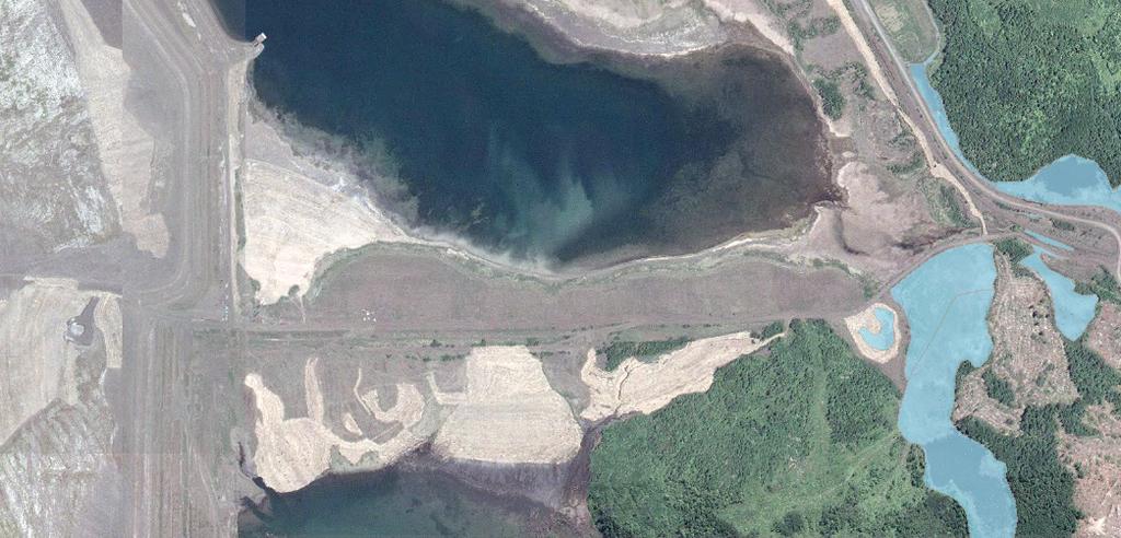
3 T27 T25 T26 T30 T23 T24 T28 T17 T19 T21 T18 T20 T29 T16 T31 T15 PEMC T14 T12 PEMC T11 PUBF T13 T10 PUBF T9 Barr Footer: Date: 6/2/2008 2:01:10 PM File: I:\Client\Polymet\Users\cdf\TailingsBasin_Alternative\TailingsBasin_Alt_Fig_1.mxd User: cdf T7 PEMC T8 T6 T4 T5 T1 PUBFx Evaluation Area Wetland Impacted Wetland 500 1,000 T2 PUBFx Figure 1 I 0 T3 2,000 Feet IMPACTED WETLANDS Tailings Basin Area PolyMet Mining Hoyt Lakes, Minnesota
4 Table 1 Field Review of Wetlands Revised June 2, 2008 NorthMet Mine/PolyMet Mining Project Area Wetland ID Circular 39 Cowardin Eggers & Reed Community Vegetation Hydrology Soil TB Mitigation Alternative - East Basin Expansion Area T1 5 PUBFx open water cattails inundated assumed hydric 1 Y Field Delineated Date(s) of Field Review Comments 3/21/2007 3/22/2007 5/21/2008 cattails on edge, no vegetation in open water area T2 5 PUBFx open water cattails inundated assumed hydric 1 Y 5/21/2008 Cattails and willows on edge with no vegetation in open water area. The wetland complex includes T2 and T3. T3 2 wet meadow grasses, willow saturated to sfc assumed hydric 1 Y 5/21/2008 This area is ditch-like and is likely inundated during higher water periods. The wetland complex includes T2 and T3. T4 2 wet meadow grasses, sedges inundated to saturated assumed hydric 1 / tailings Y 5/21/2008 Water is ponding (6-12 inches) in the depressional area at the toe of the hillslope. The south end of his area is generally dominated by cattails or willows in areas. Other areas are dominated by sedges and grasses. Inundation appears to be more than normal but area should be saturated most of the time given the topographic location. The wetland complex includes T4 and T5. T5 2 wet meadow grasses, sedges inundated to saturated tailings Y 5/21/2008 This area includes the road ditch and flow across to T4. It is inundated with 1-2 inches of water or saturated. The area has some sedges but is generally devoid of vegetation. Soil is fill consisting of tailings. The wetland complex includes T4 and T5. T6 6 shrub carr birch, willows, gasses saturated tailings Y 5/21/2008 Area is located in a low depressional area of the ditch between the road and the toe of the hillslope. T7 3 PEMC shallow marsh cattails inundated to saturated assumed hydric 1 / tailings Y 5/21/2008 This is an open water with small trees/shrubs on the edges in the south and cattails on the edges in the north. At the far south end, where the inundation is less than 1 ft, is dominated by willows, Phragmites, grasses as transition south out of the wetland. T8 2 wet meadow sedges, grasses saturated assumed hydric 2 / south end of ash hill Y 5/21/2008 This is a narrow area where surface water (< 1" deep) is flowing to T7. Some areas are only. This narrow area flows west on the backslope. The origin of the area is near the origin of T9, however, it is not connected to T9. T9 2 wet meadow cattails, sedges,grasses saturated assumed hydric 2 / east side of ash hill Y 5/21/2008 The origin of this stream is at the base of a steep hill with water flowing to the north to T10. On the backslope this is a flowing stream, but as the slope flattens, the stream widens and cattails are dominant. The wetland complex includes T9, T10, T11, T12, and T13. T10 5 PUBF open water cattails, willows inundated assumed hydric 1 Y 5/21/2008 T9 flows into the southeast corner of T10 in area that is inundated with 1-2 ft of water and is dominated by cattails. Willows and cattails surround the remainder of the basin that is inundated with >2 ft of water. The wetland complex includes T9, T10, T1 T12, and T13. T11 5 PUBF open water cattails inundated assumed hydric 1 Y 5/21/2008 T11 is connected to T10 and has similar characteristics. However, the area is becomes narrower to the north as the water flow enters a ditch (T13) which connects to T14. The wetland complex includes T9, T10, T11, T12, and T13. T12 3 PEMC shallow marsh cattails inundated assumed hydric 1 Y 5/21/2008 This is a ditch that connects T11 and T12 with cattails and some open water that is 1-3 ft deep. The wetland complex includes T9, T10, T11, T12, and T13. T13 4 deep marsh cattails inundated assumed hydric 1 Y 5/21/2008 This is a large open water wetland with cattails, some willow and grasses, on the west edge within the evaluation area. The wetland complex includes T9, T10, T11, T12, and T13. T14 4 deep marsh cattails inundated assumed hydric 1 / tailings Y 5/21/2008 5/22/2008 This is a large wetland complex dominated by cattails. There were no dead black spruce trees observed. The area was inundated but depth unknown in center of wetland. T15 3 PEMC shallow marsh cattails inundated assumed hydric 1 Y 5/21/2008 This area was dominated by Phragmites on parts of the south edge with cattails throughout the basin. It is located in a depressional area that appears to be at least partially created. There is an upland area on the east side of T15 that separates T15 from T14. T31 7 coniferous swamp cattails saturated 3 assumed hydric 1 Y 5/21/2008 This area is on the north side of T14 and this area appeared to be somewhat forested compared to T14. TB Mitigation Alternative - Buttress Area T16 4 deep marsh cattails inundated assumed hydric 1 Y 5/22/2008 This area is inundated (>1-2 ft). Vegetation is dominated by cattails, dead black spruce trees with willows and birch on the south edge. Within the evaluation area, the wetland complex includes T17, T16, and T29. T17 7 coniferous swamp cattails saturated 3 assumed hydric 1 Y T18 4 deep marsh cattails inundated assumed hydric 1 Y T19 4 deep marsh cattails inundated assumed hydric 1 Y T20 7 coniferous swamp cedar inundated assumed hydric 1 Y T21 6 shrub carr willow inundated assumed hydric 1 Y T23 7 coniferous swamp black spruce inundated assumed hydric 2 Y T24 7 coniferous swamp black spruce inundated assumed hydric 3 Y T25 6 shrub carr willows, birch inundated assumed hydric 3 Y T26 6 shrub carr willows, birch inundated assumed hydric 3 Y T27 7 coniferous swamp black spruce inundated assumed hydric 3 Y T28 7 coniferous swamp black spruce inundated assumed hydric 4 Y 5/22/2008 This area is appears to be saturated since live black spruce is observed in the area. Within the evaluation area, the wetland complex includes T17, T16, and T29. 5/22/2008 This area is inundated (>1-2 ft). Vegetation is dominated by cattails with dead black spruce trees present. On the south edge is Phragmites with some willows. The east and west edges have some live black spruce trees. 5/22/2008 This area is inundated (>1-2 ft). Vegetation is dominated by cattails with dead black spruce trees present. Within the evaluation area, the wetland complex includes T19 through T28 and T30. 5/22/2008 This area is on the south edge of T19. It is inundated with less than 1 ft of water. Cedar is present in this area. Within the evaluation area, the wetland complex includes T19 through T28 and T30. 5/22/2008 This is an area of willows and other shrubby vegetation located on the south side of T19. Within the evaluation area, the wetland complex includes T19 through T28 and T30. 5/22/2008 There is a small area of black spruce present on the south side of T19. Within the evaluation area, the wetland complex includes T19 through T28 and T30. 5/22/2008 There is a small area of black spruce present on the south side of T19. Within the evaluation area, the wetland complex includes T19 through T28 and T30. 5/22/2008 An area of willows and small birch are present along the ditch with some black spruce. Within the evaluation area, the wetland complex includes T19 through T28 and T30. 5/22/2008 This area is inundated. vegetation includes willows and birch with some black spruce. Within the evaluation area, the wetland complex includes T19 through T28 and T30. 5/22/2008 There is a small area of black spruce present with some black spruce. Within the evaluation area, the wetland complex includes T19 through T28 and T30. 5/22/2008 There is a small area of black spruce present on the south side of T19. Within the evaluation area, the wetland complex includes T19 through T28 and T30. T29 2 wet meadow cattails saturated assumed hydric 1 Y 5/22/2008 This area is saturated. Vegetation is dominated by cattails with willows and birch also present. Within the evaluation area, the wetland complex includes T17, T16, and T29. T30 6 shrub carr cattails inundated assumed hydric 2 Y 5/22/2008 This area is inundated. vegetation includes willows and birch with some black spruce. Within the evaluation area, the wetland complex includes T19 through T28 and T30. 1 The soil was assumed to be hydric because: 1) the vegetation and hydrology met the criteria for a wetland, and 2) the area was depressional and generally located at the toe of the slope. 2 The soil was assumed to be hydric because: 1) the vegetation and hydrology met the criteria for a wetland, and 2) the area was on the backslope and water was flowing through a defined channel. 3 This area was reviewed from the road so hydrology is assumed to be saturated since there were no dead black spruce trees observed. P:\Mpls\23 MN\69\ \WorkFiles\WO 008 Corps Wetlands Permit\WetlandDelineationReport\Tailings Basin Mitigation Alternative\TB_MitigationAlt_WetlandImpacts_all_TablesTable 1 1
5 Table 2 Projected Wetland Impact Detail June 2, 2008 NorthMet Mine/PolyMet Mining Project Area Wetland ID Circular 39 Total Wetland Area Projected Total Wetland Impacts Projected Indirect Wetland Impacts Eggers & Reed Community Vegetative Diversity/ Integrity Overall Wetland Quality Disturbance Level Disturbance Wetland Origin Field Delineated Impact (Direct/Indirect) Expansion Area T open water Low Low High Impounded Natural Y Direct Expansion Area T open water Low Low High Impounded Natural Y Direct Expansion Area T wet meadow Low Low High Ditch Created Y Direct Expansion Area T wet meadow Low Low High Road Fill Created Y Direct Expansion Area T wet meadow Low Low High Road Fill Created Y Direct Expansion Area T shrub carr Low Low High Road Fill Created Y Direct Expansion Area T shallow marsh Low Low High Impounded Created Y Direct Expansion Area T wet meadow Low Low High Seepage Created Y Direct Expansion Area T wet meadow Low Low High Seepage Created Y Direct Expansion Area T open water Low Low High Impounded Natural Y Direct Expansion Area T open water Low Low High Impounded Natural Y Direct Expansion Area T shallow marsh Low Low High Impounded Created Y Direct Expansion Area T deep marsh Low Low High Impounded Natural Y Direct Expansion Area T deep marsh Low Low High Impounded Natural Y Direct Expansion Area T shallow marsh Low Low High Impounded Created Y Direct Expansion Area T coniferous swamp Low Low High Impounded Natural Y Direct Expansion Area TB Mitigation Alternative - Buttress Area T deep marsh Low Low High Ditch Created Y Direct TB Mitigation Alternative - Buttress Area T coniferous swamp Low Low High Impounded Natural Y Direct TB Mitigation Alternative - Buttress Area T deep marsh Low Low High Impounded Natural Y Direct TB Mitigation Alternative - Buttress Area T deep marsh Low Low High Ditch / Impounded Natural Y Direct TB Mitigation Alternative - Buttress Area T coniferous swamp Low Low High Impounded Natural Y Direct TB Mitigation Alternative - Buttress Area T shrub carr Low Low High Impounded Natural Y Direct TB Mitigation Alternative - Buttress Area T coniferous swamp Low Low High Impounded Natural Y Direct TB Mitigation Alternative - Buttress Area T coniferous swamp Low Low High Impounded Natural Y Direct TB Mitigation Alternative - Buttress Area T shrub carr Low Low High Impounded Natural Y Direct TB Mitigation Alternative - Buttress Area T shrub carr Low Low High Impounded Natural Y Direct TB Mitigation Alternative - Buttress Area T coniferous swamp Low Low High Impounded Natural Y Direct TB Mitigation Alternative - Buttress Area T shrub carr Low Low High Impounded Natural Y Direct TB Mitigation Alternative - Buttress Area T wet meadow Low Low High Ditch Created Y Direct TB Mitigation Alternative - Buttress Area T shrub carr Low Low High Impounded Natural Y Direct TB Mitigation Alternative - Buttress Area P:\Mpls\23 MN\69\ \WorkFiles\WO 008 Corps Wetlands Permit\WetlandDelineationReport\Tailings Basin Mitigation Alternative\TB_MitigationAlt_WetlandImpacts_all_TablesTable 2 1
6 Table 3 Summary of Wetlands Revised June 2, 2008 NorthMet Mine/PolyMet Mining Wetland Evaluation Area Circular 39 Cowardin Buttress Area East Basin Expansion Area PEMC PUBF, PUBFx TOTAL P:\Mpls\23 MN\69\ \WorkFiles\WO 008 Corps Wetlands Permit\WetlandDelineationReport\Tailings Basin Mitigation Alternative\TB_MitigationAlt_WetlandImpacts_all_TablesTable 3
Preliminary Site Evaluation
 Preliminary Site Evaluation 100 Acre Site, US 72 Piperton, Tennessee Power Distributor: Chickasaw Electric Cooperative August 2010 SITE DATA SHEET PIPERTON US 72 SITE (100 ACRES): LOCATION & GENERAL DESCRIPTION
Public Notice ISSUED: December 10, 2018 EXPIRES: January 9, 2019
 APPLICANT: REFER TO: St. Louis and Lake Counties Regional Rail Authority 2018-01942-ARC Public Notice ISSUED: December 10, 2018 EXPIRES: January 9, 2019 SECTION:404 - Clean Water Act 1. APPLICATION FOR
HYDROLOGY OF GLACIAL LAKES, FORT SISSETON AREA
 PROC. S.D. ACAD. SCI., VOL. 77 (1998) 59 HYDROLOGY OF GLACIAL LAKES, FORT SISSETON AREA Perry H. Rahn Department of Geology & Geological Engineering South Dakota School of Mines and Technology Rapid City,
Mr. Michael Malone CPS Energy 145 Navarro Street San Antonio, Texas Project No
 January 15, 2016 Mr. Michael Malone 145 Navarro Street San Antonio, Texas 78205 Project No. 0328985 Environmental Resources Management CityCentre Four 840 West Sam Houston Pkwy N. Suite 600 Houston, Texas
Attachment G STREAM IMPACTS. Ridge Road Extension Alternatives Analysis
 Attachment G STREAM IMPACTS for: Ridge Road Extension Alternatives Analysis PREPARED FOR: Pasco County Engineering Services Department PREPARED BY: NV5, INC. 6989 E. FOWLER AVENUE TAMPA, FLORIDA 33617
RECREATION. Seven issues were identified that pertain to the effects of travel management on outdoor recreation within portions of the project area.
 RECREATION Seven issues were identified that pertain to the effects of travel management on outdoor recreation within portions of the project area. OPPORTUNITIES FOR SOLITUDE / QUIET TRAILS. One attraction
METROPOLITAN COUNCIL 390 North Robert Street, St. Paul, MN Phone (651) TDD (651)
 TDD (651)") DATE: March 27, 2012 METROPOLITAN COUNCIL 390 North Robert Street, St. Paul, MN 55101 Phone (651) 602-1000 TDD (651) 291-0904 TO: Metropolitan Parks and Open Space Commission FROM: Arne Stefferud, Planning
DATE: March 27, 2012 METROPOLITAN COUNCIL 390 North Robert Street, St. Paul, MN 55101 Phone (651) 602-1000 TDD (651) 291-0904 TO: Metropolitan Parks and Open Space Commission FROM: Arne Stefferud, Planning
The Potentially Dangerous Glacial Lakes
 Chapter 11 The Potentially Dangerous Glacial Lakes On the basis of actively retreating glaciers and other criteria, the potentially dangerous glacial lakes were identified using the spatial and attribute
Agenda Report. Spruce Street Outlet Drainage Improvements Tower Road Relief Sewer
 Agenda Report Subject: Prepared By: Spruce Street Outlet Drainage Improvements Tower Road Relief Sewer Steven M. Saunders, Director of Public Works/Village Engineer Date: August 12, 2012 On March 8, 2012
Mille Lacs Moraine SNA Approach
 Approach Tower Road N46 16.636 W93 51.289 N46 16.491 W93 51.285 s Parking N46 16.329 W93 51.265 Approach Tower Road N46 16.636 W93 51.289 N46 16.491 W93 51.285 s Parking N46 16.329 W93 51.265 Borden s
Version Isolated & Non-Waters Only 1 of 3
 APPROVED JURISDICTIONAL DETERMINATION FORM U.S. Army Corps of Engineers SECTION I: BACKGROUND INFORMATION A. REPORT COMPLETION DATE FOR APPROVED JURISDICTIONAL DETERMINATION (JD): July 6, 2010. B. DISTRICT
Original Report F WIN , F WIN Prepared for Northland Power and Ministry of Tourism and Culture
 STAGE 2 ARCHAEOLOGICAL ASSESSMENT McLEAN S MOUNTAIN WIND FARM Part Lots 12-15, Concession 3 Geographic Township of Howland Part Lot 24, Concession 12 Geographic Township of Bidwell and Goat Island (formerly
David Magney Environmental Consulting
 David Magney Environmental Consulting DELINEATION OF JURISDICTIONAL WATERS AND RIPARIAN HABITATS FOR LYONS CANYON RANCH, NEWHALL, CALIFORNIA Prepared for: UNITED STATES ARMY CORPS OF ENGINEERS and CALIFORNIA
What Is An Ecoregion?
 Ecoregions of Texas What Is An Ecoregion? Ecoregion a major ecosystem with distinctive geography, characteristic plants and animals, and ecosystems that receives uniform solar radiation and moisture Sometimes
Hydraulic Report. Trail 5 Snowmobile Trail Over Mulligan Creek. Prepared By: COLEMAN ENGINEERING COMPANY Karisa V. Falls, P.E.
 Prepared for: Prepared by: Marquette County Road Commission Coleman Engineering Company Marquette, Michigan Iron Mountain, MI December 2011 Hydraulic Report Trail 5 Snowmobile Trail Over Mulligan Creek
Decision Memo for Desolation Trail: Mill D to Desolation Lake Trail Relocation
 for Salt Lake County, Utah Uinta-Wasatch-Cache National Forest Salt Lake Ranger District 1. Background The present location of the Desolation Trail (#1159) between Mill D and Desolation Lake follows old
APPENDIX D: SUSTAINABLE TRAIL DESIGN. APPENDICES Town of Chili Parks and Recreation Master Plan Update
 APPENDIX D: SUSTAINABLE TRAIL DESIGN APPENDICES Town of Chili Parks and Recreation Master Plan Update Sustainable Trail Construction Sustainable trails are defined by the US Forest Service as trails having
3.0 EXISTING PARK & RECREATION SPACE
 3.0 EXISTING PARK & RECREATION SPACE TOWN PARK & RECREATION SPACE An inventory of current parks and recreation area in the Town of Cedarburg is shown in Table 3. These areas total roughly 381.89 acres.
Crystal Spring SNA. Washington County N W N W N W N W N W92 45.
 W92 45.899 W92 45.835 W92 45.826 W92 45.814 Z o av ral eek s C r N45 15.465 W92 45.972 N45 15.439 W92 46.102 W92 45.913 hidden cove N45 15.413 W92 45.857 W92 45.791 W92 45.899 W92 45.835 W92 45.826 W92
Region 1 Piney Woods
 Region 1 Piney Woods Piney Woods 1. This ecoregion is found in East Texas. 2. Climate: average annual rainfall of 36 to 50 inches is fairly uniformly distributed throughout the year, and humidity and temperatures
Croatia completes inventory of wetlands
 Croatia completes inventory of wetlands 16 October 2006 Croatia CRO-WET - Croatian Wetland Inventory SGF project completed The Croatian State Institute for Nature Protection (SINP) carried out a comprehensive
Table 1: Margarita (SDSU) Communication Site. Latitude 1 Longitude 1 Elev 2 Address T/R/S 3 APN 4 USGS Quadrangle
 Communication Site. Latitude 1 Longitude 1 Elev 2 Address T/R/S 3 APN 4 USGS Quadrangle") County of Riverside Public Safety Enterprise Communication Project Appendix A: Candidate Site Descriptions Margarita (SDSU) Communication Site Margarita (SDSU) Communication Site Overview The site is located
County of Riverside Public Safety Enterprise Communication Project Appendix A: Candidate Site Descriptions Margarita (SDSU) Communication Site Margarita (SDSU) Communication Site Overview The site is located
Segment 2: La Crescent to Miller s Corner
 goal of the USFWS refuges is to conserve, protect and enhance fish, wildlife and plants and their habitats for the continuing benefit of the American people. Refuge lands are used largely for fishing,
Photographic Log Client: Project Number: Site Location: Site Name: Photograph ID: Date: Location: Direction: Comments: Photograph ID:
 Photograph ID: 1 west View of one of the monitoring well and the large parking lot on the south side of Center Street. Photograph ID: 2 Monitoring well located in the middle of the parking lot located
Town of Oakfield Agricultural and Farmland Protection Plan
 SECTION III COMMUNITY OVERVIEW A. Regional Setting / Location The Town of Oakfield is located in the northwestern portion of Genesee County. Located west of New York's Finger Lakes, the Town is uniquely
DIXIE HIGHWAY Region of Peel NAI Area # 1304, 1320, 2449, 2625, 3961
 DIXIE HIGHWAY 407 1 Region of Peel NAI Area # 1304, 1320, 2449, 2625, 3961 Toronto and Region Conservation Authority City of Brampton Size: 36 hectares Watershed: Etobicoke Creek Con 4 E, Lots 13, 14 Ownership:
Agenda. City of Ocean Shores City Council Study Session. Monday August 8, :00 PM
 Agenda City of Ocean Shores City Council Study Session Monday August 8, 2011 1:00 PM Ocean Shores Convention Center 120 Chance A La Mer Ocean Shores, Washington Call to Order Discussion 1. Weatherwax Wetland
Seager Wheeler Lake. Representative Area. -- Concept Management Plan --
 Seager Wheeler Lake Representative Area -- Concept Management Plan -- Saskatchewan Environment and Resource Management January, 1999 Saskatchewan s Representative Areas Network Program The Government of
Chapter 4.0 Alternatives Analysis
 Chapter 4.0 Alternatives Analysis Chapter 1 accumulated the baseline of existing airport data, Chapter 2 presented the outlook for the future in terms of operational activity, Chapter 3 defined the facilities
ANAGEMENT. LAN November, 1996
 M ANAGEMENT P LAN November, 1996 for Paul Lake Provincial Park Ministry of Environment, Lands and Parks BC Parks Department Paul Lake Provincial Park M ANAGEMENT P LAN Prepared by BC Parks Kamloops Area
Elevation. Plate 1 - Study Area Geomorphology. Glacial Deposition. Unit. 1-ft Contours. 1,000 Feet. batavia member carmi member haeger till member
 Plate 1 - Study Area Geomorphology Glacial Deposition Unit flowage basin batavia member carmi member haeger till member marshy valley wadsworth till member Streams & Flowage Paths Elevation /"% 1-ft Contours
STUDY REPORT TR-08 CALIFORNIA TIGER SALAMANDER ATTACHMENT A CTS SITE ASSESSMENT
 STUDY REPORT TR-08 CALIFORNIA TIGER SALAMANDER ATTACHMENT A CTS SITE ASSESSMENT Table of Contents Section. Description Page. 1.0 DON PEDRO RESERVOIR STUDY AREA... 1-1 1.1 Sites Potentially Suitable for
II. GENERAL DESCRIPTION OF ENVIRONMENTAL SETTING
 II. GENERAL DESCRIPTION OF ENVIRONMENTAL SETTING A. LOCATION AND BOUNDARIES The proposed Canyon Hills project site is located at 8000 West La Tuna Canyon Road in the City of Los Angeles (the City ). The
Appendix A Appendix A (Project Specifications) Auk Auk / Black Diamond (Trail 44) Reroute
 Auk Auk / Black Diamond (Trail 44) Reroute") Appendix A (Project Specifications) Auk Auk / Black Diamond (Trail 44) Reroute I. Proposed Action: This project proposes to reroute approximately 1,800 feet of a 50 inch wide trail, off of private property
Appendix A (Project Specifications) Auk Auk / Black Diamond (Trail 44) Reroute I. Proposed Action: This project proposes to reroute approximately 1,800 feet of a 50 inch wide trail, off of private property
CHAPTER III: TRAIL DESIGN STANDARDS, SPECIFICATIONS & PERMITS
 CHAPTER III Trail Design Standards, Specifications & Permits This chapter discusses trail standards, preferred surface types for different activities, permits, and other requirements one must consider
ENVIRONMENT Environmental Service PRKLND REION, Red Deer F1 F F1 L1 F1 L1 M1 F4 F1 F2 F1 F2 L3 L1 F2 L1 L1 Map 2 Dillberry Lake Provincial Park Projec
 ENVIRONMENT Environmental Service PRKLND REION, Red Deer 67 66 68 69 65 64a,b 63 82 70 77 71 78 72 73 74 76 75 40a 40b 41 42 46 60 61 59 58 83 90 89 39 43 38 44 37 45 47 79 80 81 49 50 51 52 48 53 54 55
Attachment D: PHOTO LOG CITY OF ARCATA RAIL-WITH-TRAIL CONNECTIVITY PROJECT
 01051-09004 Attachment D: PHOTO LOG CITY OF ARCATA RAIL-WITH-TRAIL CONNECTIVITY PROJECT DRAFT: June 30, 2010 Applicant: City of Arcata 736 F Street Arcata, CA 95521 Phone (707) 825-2154 Prepared by: Winzler
Labrador - Island Transmission Link Target Rare Plant Survey Locations
 27-28- Figure: 36 of 55 29-28- Figure: 37 of 55 29- Figure: 38 of 55 #* Figure: 39 of 55 30- - east side Figure: 40 of 55 31- Figure: 41 of 55 31- Figure: 42 of 55 32- - secondary Figure: 43 of 55 32-
Ditch flows slowly to the north
 Ditch flows slowly to the north Photo 1. Wetland DE: Looking west across Wetland DE from upslope. Ponded water, mucky mineral soils, and patches of emergent vegetation observed. Wetland DE appears to be
Specification for Grip blocking using Peat Dams
 Technical Guidance Note 1 Specification for Grip blocking using Peat Dams 1. Introduction Moorland drains (grips) have been dug across much of the Yorkshire upland peatlands. Many of these grips have become
Lake Wissota Access Locations within the LaFayette Township. By Chad Martin
 Lake Wissota Access Locations within the LaFayette Township By Chad Martin Anson/ Wissota Access Point # 1 Road: 195 th St. Associated Fire Numbers: 13294 Defining Characteristics: Forested from road
Waukegan & Calumet Rivers. All Hands Meeting
 Waukegan & Calumet Rivers 516(e) Update All Hands Meeting David F. Bucaro, P.E. Chief, Economic Formulation & Analysis Section, Planning Branch May 18 th, 2011 Kensington Court Ann Arbor, MI 1 2 Waukegan
Auburn Trail / Ontario Pathways Trail Connector Feasibility Study Public Information Meeting Wednesday, August 22, 2012
 Auburn Trail / Ontario Pathways Trail Connector Feasibility Study Public Information Meeting Wednesday, August 22, 2012 Purpose of Feasibility Study Purpose Evaluate the feasibility of constructing a multiuse
RAILS WITH TRAILS ALBANY TO CORVALLIS PEDESTRIAN AND BICYCLE PATH FEASIBILITY STUDY
 RAILS WITH TRAILS ALBANY TO CORVALLIS PEDESTRIAN AND BICYCLE PATH FEASIBILITY STUDY September 2004 Benton County Public Works Chuck Knoll, P.E., Senior Engineer Andrew Monaco, GIS Analyst and Maps Mark
ROUTE ANALYSIS PROCESS
 ROUTE ANALYSIS PROCESS Progress to Date: 1. Recorded and labeled all routes received from PAT Meetings. 2. Determined opportunity, avoidance and exclusion areas crossed by PAT proposed routes. 3. Routes
White Mountain National Forest. Pond of Safety Accessible Trail & Shoreline Access Project. Scoping Report. Township of Randolph Coos County, NH
 White Mountain National Forest United States Department of Agriculture Forest Service Eastern Region Pond of Safety Accessible Trail & Shoreline Access Project Township of Randolph Coos County, NH Scoping
January 19, 2018 Project No C Via
 Mr. Thomas McDonald, P.E. Professional Engineer II (C/E) Water Management NYS Canal Corporation 30 S Pearl Street Albany, NY 12207 January 19, 2018 Project No. 16-5719C Via email: thomas.mcdonald@canals.ny.gov
Nature Conservation Agency (NCA) Salacgrīva 05/07/2018
 Salacgrīva 05/07/2018") Nature Conservation Agency (NCA) Salacgrīva 05/07/2018 Nature Conservation Agency ensures implementation of unified nature protection policy in Latvia Specially protected nature areas in Latvia Specially
Nature Conservation Agency (NCA) Salacgrīva 05/07/2018 Nature Conservation Agency ensures implementation of unified nature protection policy in Latvia Specially protected nature areas in Latvia Specially
Mountain Valley Pipeline, LLC Mountain Valley Pipeline Project Docket No. CP
 16. Prior to construction, Mountain Valley shall file with the Secretary, for review and approval by the Director of OEP, a segment-specific construction and operation access plan for the area between
Recreational Use Attainability Analysis Summary of Findings & Public Comment
 The Neches River Above Lake Palestine, Prairie Creek, Mud Creek, and West Mud Creek Recreational Use Attainability Analysis Summary of Findings & Public Comment Texas Institute for Applied Environmental
II. THE BOULDER CREEK DRAINAGE BASIN
 II. THE BOULDER CREEK DRAINAGE BASIN This section provides an overview of the watersheds and flood hazards associated with Boulder Creek and South Boulder Creek including descriptions of the drainage basins,
Budi Hadi Narendra Harris Herman Siringoringo Chairil Anwar Siregar. Research and Development Center for Forest
 Budi Hadi Narendra Harris Herman Siringoringo Chairil Anwar Siregar Research and Development Center for Forest Background Coastal management should be wisely done as a part of watershed management. Typologically,
Non-motorized Trail Plan & Proposal. August 8, 2014
 Town of Star Valley Ranch, Wyoming and the Star Valley Ranch Association in partnership with the USDA Forest Service, Bridger-Teton National Forest, Greys River Ranger District Non-motorized Trail Plan
White Oak Creek. Recreational Use Attainability Analysis Summary of Findings. Texas Institute for Applied Environmental Research Stephenville, Texas
 White Oak Creek Recreational Use Attainability Analysis Summary of Findings Texas Institute for Applied Environmental Research Stephenville, Texas August 8, 2016 Sulphur Springs, Texas August 9, 2016 Mount
DRAFT. Dorabelle Campground Rehabilitation
 DRAFT Dorabelle Campground Rehabilitation September 2012 1.1 REGIONAL SETTING AND PROJECT LOCATION The Dorabelle Campground is located on the western shore of Shaver Lake in Fresno County, California (Section
SECTION 3 GENERAL DESCRIPTION OF THE RIVER BASIN
 SECTION 3 GENERAL DESCRIPTION OF THE RIVER BASIN SECTION 3 GENERAL DESCRIPTION OF THE RIVER BASIN River basin description. A general description of the river basin or subbasin, as appropriate, in which
United States Department of the Interior National Park Service. Boundary Expansion Listed in National Register January 11, 2017
 NPS Form 10900-a (Rev. 8/2002) OMB No. 10240018 United States Department of the Interior National Park Service Boundary Expansion Listed in National Register January 11, 2017 National Register of Historic
X. WHATCOM CREEK SMA. X.1 Watershed Analysis. X.1.1 Landscape Setting
 X. WHATCOM CREEK SMA Summary: The entire length of Whatcom Creek is located within the City of Bellingham. SMA jurisdiction associated with this creek is approximately 300 acres. Land use is dominated
AIRPORT MASTER PLAN ADVISORY COMMITTEE MEETING #2 AGENDA
 AIRPORT MASTER PLAN ADVISORY COMMITTEE MEETING #2 AGENDA MEETING DATE: Wednesday, June 1, 2011 TIME: 2:30 PM (1½ Hours) LOCATION: Duluth Airport Terminal Building, Skyline Room (2 nd Floor) This meeting
ROAD AND TRAIL PROJECT APPROVAL
 ROAD AND TRAIL PROJECT APPROVAL www.marincountyparks.org Marin County Parks, 3501 Civic Center Dr, Suite 260, San Rafael, CA 94903 DATE: July 12, 2017 PRESERVE: Gary Giacomini Open Space Preserve PROJECT:
TRANSMITTAL. Please contact me with any questions. 7 Spruce Road, Freeport, ME T: (207)
") BAKER DESIGN CONSULTANTS Civil, Marine and Structural Engineering To: Alex Jaegerman FAICP Director of Planning & Development Town of Yarmouth 200 Main Street PO Box 907 Yarmouth, ME 04096 From: Barney
BAKER DESIGN CONSULTANTS Civil, Marine and Structural Engineering To: Alex Jaegerman FAICP Director of Planning & Development Town of Yarmouth 200 Main Street PO Box 907 Yarmouth, ME 04096 From: Barney
Physical. and. Human-made. Features
 Directions for Making a Geographic Features Vocabulary Book 1. Cut the photographs boxes out of page 2 and sort the them into two groups: physical features and human-made features. 2. Correctly match each
Bayview Escarpment. Interim Management Statement
 Bayview Escarpment Interim Management Statement Bayview Escarpment Provincial Nature Reserve Interim Management Statement January 15, 1995 REGIONAL DIRECTOR'S APPROVAL STATEMENT This Interim Management
Susitna-Watana Hydroelectric Project (FERC No ) Recreation Resources Study Study Plan Section Study Implementation Report
 Recreation Resources Study Study Plan Section Study Implementation Report") (FERC No. 14241) Recreation Resources Study Study Plan Section 12.5 2014 Study Implementation Report Prepared for Prepared by AECOM November 2015 TABLE OF CONTENTS 1. Introduction... 4 2. Study Objectives...
(FERC No. 14241) Recreation Resources Study Study Plan Section 12.5 2014 Study Implementation Report Prepared for Prepared by AECOM November 2015 TABLE OF CONTENTS 1. Introduction... 4 2. Study Objectives...
Section 3-04 Cross Sectional Elements TABLE OF CONTENTS. INTRODUCTION...3 General...3 Exhibit 1-Cross-Sectional Elements...3
 Section 3-04 Cross Sectional Elements TABLE OF CONTENTS INTRODUCTION...3 General...3 Exhibit 1-Cross-Sectional Elements...3 CROSS-SECTIONAL ELEMENTS...3 Traveled Way...3 Shoulder...3 Surfacing Taper...3
SUBJECT: Newark Bay Study Area Coordination Team Meeting, 9 October 2012
 CENAN-PP-H 9 Oct 12 MEMORANDUM FOR RECORD SUBJECT: Newark Bay Study Area Coordination Team Meeting, 9 October 2012 1. The regularly scheduled monthly interagency coordination meeting was held on 9 Oct
DECISION MEMO. Rawhide Trail #7073 Maintenance and Reconstruction
 Page 1 of 6 Background DECISION MEMO USDA Forest Service Jefferson Ranger District Jefferson County, Montana Rawhide Trail #7073 is located in the Elkhorn Mountain Range approximately 10 miles east of
Trail Assessment Report
 Trail Assessment Report Trail Options for the Bear Creek Canyon located in Pikes Peak Ranger District, Pike National Forest and on Colorado Springs Utility Lands Due to the presence of a unique species
124 Blarney Drive Columbia, South Carolina
 For Sale ±2.99 AC Commercial Land Two N otch Rd. Exit 7 Site 24 Blarney Drive Columbia, South Carolina Exclusively Offered By: Tom Milliken O: + 803 744 9837 C: + 803 33 6999 E: tmilliken@naiavant.com
Dungeness Recreation Area County Park Master Plan
 Dungeness Recreation Area County Park Public Outreach Meeting October 10, 2007 Project Overview USFWS Site Dungeness Recreation Area County Park Meeting Objectives: Re-Introduce project; provide status
Wallowa Falls Hydroelectric Project FERC Project No. P-308 Proposed Study Plans - Recreation August 2011
 Wallowa Falls Hydroelectric Project FERC Project No. P-308 August 2011 Prepared by: PacifiCorp Energy Hydro Resources 825 NE Multnomah, Suite 1500 Portland, OR 97232 For Public Review Wallowa Falls Hydroelectric
DIGITAL TERRAIN AND VIEWSHED ANALYSIS CRATER LAKE NATIONAL PARK
 DIGITAL TERRAIN AND VIEWSHED ANALYSIS OF FINDING THE IDEAL CAMPSITE ALONG THE PACIFIC CREST TRAIL Source: Outdoor Travel Blog DON RYAN DIGITAL TERRAIN ANALYSIS GEOG 593 PROJECT OVERVIEW LOCATION HISTORY
IOWA ORNITHOLOGISTS' UNION - Birding Sites in Dallas County
 IOWA ORNITHOLOGISTS' UNION - Birding Sites in Dallas County Printed on 7/19/2018 Beaver Bottoms Wetland (restricted) (Important Bird Area) GPS Coordinates:, Ownership: Private (see directions for access)
Lake Tahoe Airport Master Plan
 Lake Tahoe Airport Master Plan City Council Briefing October 20, 2015 What is an Airport Master Plan? a comprehensive study of an airport [that] usually describes the short, medium, and long term development
Kit Carson-Challenger Ridge Trail Project Annual Performance Report-2014 October 22, 2014
 1 Kit Carson-Challenger Ridge Trail Project Annual Performance Report-2014 October 22, 2014 Willow Lake and Kit Carson Peak 2 SUMMARY The Rocky Mountain Field Institute began Phase 1 of a multi-phase,
Pinellas County Environmental Lands
 Pinellas County Environmental Lands In addition to traditional parks and recreation facilities, Pinellas County owns and manages a system of environmental lands that provides specialized resource-based
Memo. Orange City Trail Plan Becky Mendez, AICP Jamie Krzeminski, PE, PTOE Matt Wiesenfeld, PE, AICP. Development of the Existing and Proposed Network
 Memo Date: Friday, December 22, 2017 Project: To: From: Subject: Trail Plan Becky Mendez, AICP Jamie Krzeminski, PE, PTOE Matt Wiesenfeld, PE, AICP Development of the Existing and Proposed Network HDR
TRAILS WHERE TO FIND TRAILS IN NOVA SCOTIA
 TRAILs SIGNAGE Know the Signs............................ 44 WHERE YOU CAN RIDE Roads and Highways........................ 46 Designated Trails........................... 47 Established Trails...........................
PCBS DELINEATION WORK PLAN
 PCBS DELINEATION WORK PLAN BLUE ISLAND NORTHEAST MIXED-USE COMMERCIAL PARK (FORMER BLUE ISLAND LANDFILL) BLUE ISLAND, COOK COUNTY, ILLINOIS PREPARED FOR: CITY OF BLUE ISLAND 13051 SOUTH GREENWOOD AVENUE
We are pleased to present Stattelman Trust - Todd County ± Acres Bertha Township, Todd County
 We are pleased to present Stattelman Trust - Todd County 86.90 ± Acres Bertha Township, Todd County SUBJECT PROPERTY This property to be sold by Sealed Bid Auction Owner: Stattelman Trust; Thomas Stattelman,
PORTISHEAD BRANCH LINE PRELIMINARY ENVIRONMENTAL INFORMATION REPORT VOLUME 4 APPENDIX Water Receptors
 PORTISHEAD BRANCH LINE PRELIMINARY ENVIRONMENTAL INFORMATION REPORT APPENDIX 17. 3 Water Receptors Contents Section Page 1 Water Receptors... 1-1 1.1 Surface Water Features/Receptors in the Study Area
Appendix C. Past and Current Management of Selected Tidal Wetland Sites
 Appendix C. Past and Current Management of Selected Tidal Wetland Sites Maps and photographs of wetland sites can be found at http://www.elkhornslough.org/tidalwetlandproject. Site 1. Parsons Slough/South
OPG, Nuclear 2
 B iodiversity Assessment Building a Biodiversity Management Plan November 24, 2011 OPG, Nuclear 2 Biodiversity Assessment What habitat, or your site? potential habitat, is available on What species of
(Short Listing) DUPUYER ACREAGE, ROCKY MOUNTAN FRONT
 DUPUYER ACREAGE, ROCKY MOUNTAN FRONT") (Short Listing) DUPUYER ACREAGE, ROCKY MOUNTAN FRONT This unique property is located 8½ miles northwest of Dupuyer, Montana and approximately thirty 30 miles northwest of Choteau, Montana. Great Falls
(Short Listing) DUPUYER ACREAGE, ROCKY MOUNTAN FRONT This unique property is located 8½ miles northwest of Dupuyer, Montana and approximately thirty 30 miles northwest of Choteau, Montana. Great Falls
Appendix I: Wetlands and Vernal Pools Functions and Values
 Appendix I: Wetlands and Vernal Pools Functions and Values Wetlands proposed to be impacted by each alternative were reviewed to determine what functions and values the wetland currently provides that
Draft Environmental Impact Statement
 United States Department of Agriculture Forest Service Pacific Southwest Region Draft Environmental Impact Statement Inyo National Forest Motorized Travel Management R5-MB-182 January 2009 Inyo Mountains
Access to the site is obtainable from the paved driveway leading to the MWD facility.
 County of Riverside Public Safety Enterprise Communication Project Appendix A: Candidate Site Descriptions Overview The site is located adjacent to a Metropolitan Water District (MWD) facility on El Sobrante
Mountain Valley Pipeline Project. Docket No. CP
 Supplemental Responses to FERC Staff s Recommended Mitigation in Draft Environmental Impact Statement December 2016 14. Prior to the end of the draft EIS comment period, Mountain Valley shall file with
Appendix I. Wilderness Review
 Appendix I. Wilderness Review This appendix contains the wilderness inventory conducted for the Ash Meadows, Moapa Valley, and Pahranagat National Wildlife Refuges (NWRs) as part of the Comprehensive Conservation
Other Agencies and Organizations
 Daniel Boone National Forest 1700 Bypass Road WInchester, KY 40391 859-745-3100 Location Northern terminus is near Morehead, Kentucky. Southern terminus is located in the Big South Fork NRRA in Tennessee.
Bear Creek Habitat Improvement Project
 06/10/10 Bear Creek Habitat Improvement Project El Paso County, Colorado Pike National Forest and Colorado Springs Utilities Owned Land Report prepared by: Eric Billmeyer Executive Director Rocky Mountain
Description of the Proposed Action for the Big Creek / Yellow Pine Travel Plan (Snow-free Season) and Big Creek Ford Project
 and Big Creek Ford Project") Description of the Proposed Action for the Big Creek / Yellow Pine Travel Plan (Snow-free Season) and Big Creek Ford Project Payette National Forest Krassel Ranger District Valley and Idaho Counties, Idaho
Description of the Proposed Action for the Big Creek / Yellow Pine Travel Plan (Snow-free Season) and Big Creek Ford Project Payette National Forest Krassel Ranger District Valley and Idaho Counties, Idaho
Appendix 4.8 A. Agency Correspondence and Final APE Statement
 Appendix 4.8 A Agency Correspondence and Final APE Statement Area of Potential Effect for Cultural Resources Introduction The South Coast Rail project requires review by the Army Corps of Engineers (Corps),
CRAZY HORSE TRAIL GUIDE
 CRAZY HORSE TRAIL GUIDE Abridged Version: July 2016 This is a short form of our interpretive trail guide for the Crazy Horse Trail. The full version of the guide has a more detailed description of the
Blanco Creek Ranch Acres, Uvalde County, Texas
 Blanco Creek Ranch 1208.30 Acres, Uvalde County, Texas James King, Agent Office 432 426.2024 Cell 432 386.2821 James@KingLandWater.com Blanco Creek Ranch 1208.30 acres Uvalde County, Texas James King,
/s/ Robert V. Abbey Director
 Form 1221-2 (June 1969) UNITED STATES DEPARTMENT OF THE INTERIOR BUREAU OF LAND MANAGEMENT MANUAL TRANSMITTAL SHEET Release 6-129 Date 03/15/2012 Subject 6310 Conducting Wilderness Characteristics Inventory
Jan Lake Representative Area -- Concept Management Plan --
 Jan Lake Representative Area -- Concept Management Plan -- Saskatchewan Environment and Resource Management December, 1999 Saskatchewan s Representative Areas Network Program The government of Saskatchewan,
Business Item No XXX. Proposed Action That the Metropolitan Council approve the Coon Creek Regional Trail Master Plan.
 Business Item No. 2015-XXX Metropolitan Parks and Open Space Commission Meeting date: July 7, 2015 For the Community Development Committee meeting of July 20, 2015 For the Metropolitan Council meeting
Buffalo Pass Trails Project
 Buffalo Pass Trails Project Hahns Peak/Bears Ears Ranger District, Medicine Bow-Routt National Forests and Thunder Basin National Grassland Routt County, Colorado T6N 83W Sections 3-5, 8; T6N 84W Sections
Skyland Ranch. At a Glance: Property Features
 Property Features Ideally positioned in an ox box of the mighty Apalachicola River, Skyland Ranch s 2 ½ miles of river frontage form the foundation of this distinctive property. Coveted by recreational