Preliminary Site Evaluation
|
|
|
- Rosamund Powers
- 5 years ago
- Views:
Transcription

1 Preliminary Site Evaluation 100 Acre Site, US 72 Piperton, Tennessee Power Distributor: Chickasaw Electric Cooperative August 2010
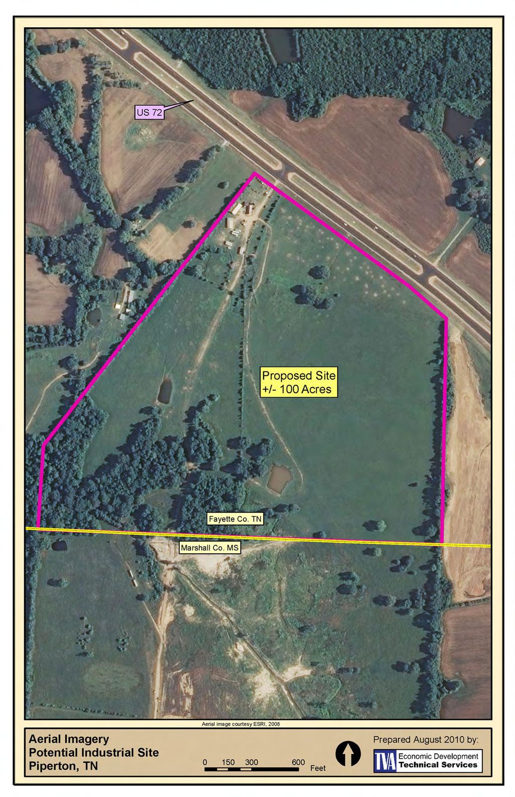
2 SITE DATA SHEET PIPERTON US 72 SITE (100 ACRES): LOCATION & GENERAL DESCRIPTION This site is located approximately 3 miles south of the City of Piperton in Fayette County, Tennessee. It consists of a single parcel encompassing approximately 100 acres and is located approximately 0.4 miles northwest of the Tennessee/Mississippi state line on US 72. The site is bounded by US 72 to the north and the state line to the south. It is located approximately 2.4 miles southeast of the intersection of State Route 385 and US 72. It is located approximately 3.2 miles south of the Piperton central business district via State Route 196, which intersects US 72 approximately 600 feet southeast of the site. TRANSPORTATION & SITE ACCESS Interstate Access... To the north, the site will eventually have access to I-40 East and the proposed north-south I-69 via State Route 385 /I- 269, which is currently under construction and scheduled for completion in late I-40 West and I-55 can also be accessed via State Route 385 and I-240 to the northwest. Highway Access:... Site is immediately adjacent to US 72 to the north, which connects Memphis with Chattanooga Local Road Access None Railroad Access:... None Airport:... Site is located approximately 25 miles from the Memphis International Airport (KMEM) via State Route 385 and I-240.
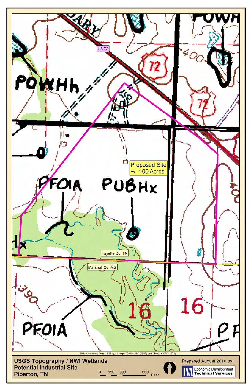
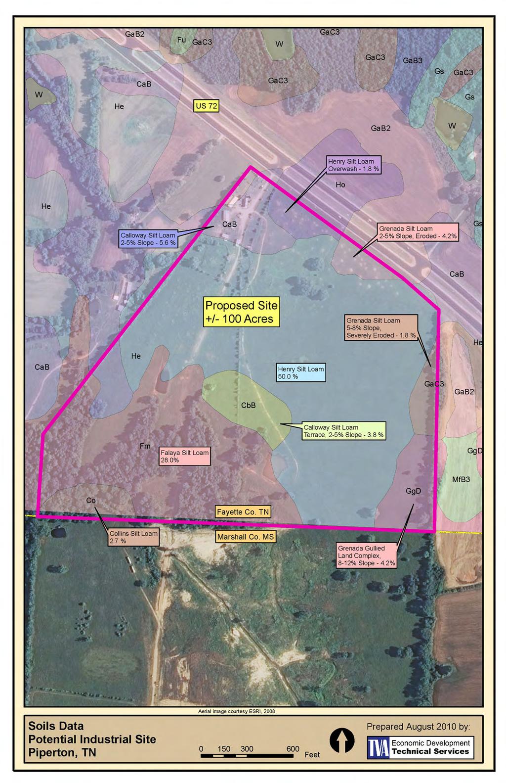
3 TOPOGRAPHY USGS maps: Quad map: Collierville (35089A6), 1983 Byhalia NW (34089G6), 1971 Elevation Range:... Approximately 375 feet to 410 feet (from USGS contours) Approximate Slopes:... +/-95% of the site is less than or equal to 5% slope +/-5% of the site is between 5% and 10% slope Predominant Terrain:... Level, approximately 15% wooded. Floodplain:... FEMA Flood Insurance Rate Map Number 47047C0395C (Effective date 11/5/08) shows that this site contains no... FEMA flood hazard areas (Zone A). Wetlands:... NWI maps indicate the presence of a small area of linear wetlands along one of the blue line streams in the southern portion of the site, although most of these are actually located in Mississippi, well clear of this site. A single nonlinear wetland area of approximately 0.3 acres, classified as PUBHx, covers an area occupied by a farm pond. TOTAL AND UNUSABLE AREAS The total area of each parcel is taken from tax records and was provided by the requestor. These acreages are noted on the aerial maps. Areas of more than 10% natural ground slope are normally classified as unusable for the purposes of these evaluations. On this site, however, there are no such areas. In addition, areas containing wetlands as listed on the National Wetlands Inventory (NWI) maps are considered to be undevelopable, with some exceptions. Finally, areas designated as official FEMA flood hazard areas (floodway or 100-year flood fringe area) have also been classified as undevelopable. These acreages are noted on the topographic maps.
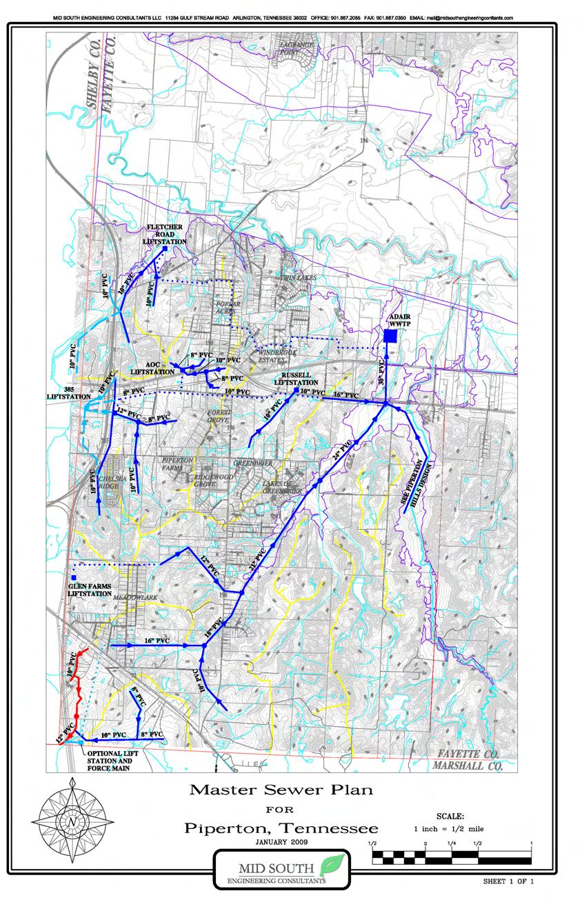
4 UTILITIES Water The Water Master Plan for Piperton was prepared in 2007 by Mid-South Engineering Consultants. (See Exhibits) This plan indicates the planned future construction of a 12 inch water line along the south side of US 72 on the north end of the site. Also shown is a proposed 10 inch water line along the west side of the site that turns and connects to an existing line in the Piperton Business Park, approximately 1 mile west of the site. Wastewater The Sewer (Wastewater) Master Plan for Piperton was prepared in 2009 by Mid- South Engineering Consultants. (See Exhibits) This plan indicates a planned future east-west gravity sewer approximately 500 feet north of the state line that ties into the existing sanitary sewer system that serves the Piperton Business Park. Electric Power The site is located within the service area of and is served by the Chickasaw Electric Cooperative. The closest TVA power line is a north-south 161 kv line located approximately 0.5 miles to the east. The nearest existing Chickasaw Electric Cooperative substation is located in near Rossville, TN, approximately 5 miles northeast of the site. Natural Gas The natural gas provider in this area is the Hardeman-Fayette Utility District, based in Moscow, TN. A 6 inch gas line runs along the north side of US 72 back towards the Shelby County line. Another 6 inch line crossing to the south side of US 72 was installed as part of the widening project. This crossing is believed to be within a few hundred feet of the site, and in any event, Hardeman-Fayette feels that they would have no problem in serving almost any type of development at this site.
5 EXHIBITS The following map exhibits are provided for the site reviewed: Aerial Imagery - (Prepared by TVA Economic Development) USGS Topographic / NWI Wetlands Map TVA Economic Development FEMA Flood Maps TVA Economic Development USDA Soils Map TVA Economic Development Piperton Sewer Master Plan 2009 Mid-South Engineering Consultants Piperton Water Master Plan 2007 Mid-South Engineering Consultants FACTORS FAVORING THIS SITE The following factors are considered to be positives for this site: Excellent topography prevails here; steep slopes are almost non-existent. Road infrastructure is excellent, with four-lane access to Interstate system CHALLENGES PRESENTED BY THIS SITE The following factors are not considered to be positives for this site: Usable area is somewhat limited by streams to south.
6
7
8
9
10
11
12
Town of Oakfield Agricultural and Farmland Protection Plan
 SECTION III COMMUNITY OVERVIEW A. Regional Setting / Location The Town of Oakfield is located in the northwestern portion of Genesee County. Located west of New York's Finger Lakes, the Town is uniquely
2.0 Physical Characteristics
 _ 2.0 Physical Characteristics 2.1 Existing Land Use for the Project The site is comprised of approximately 114 acres bounded by Highway 101 to the north, the existing town of Los Alamos to the east, State
Northeast Quadrant Distinctive Features
 NORTHEAST QUADRANT Northeast Quadrant Distinctive Features LAND USE The Northeast Quadrant includes all the area within the planning area that is east of Interstate 5 and to the north of State Route 44.
RACER Properties in Saginaw Area
 RACER Properties in Saginaw Area Bruce Rasher, Redevelopment Manager brasher@racertrust.org Saginaw Area, MI Overview See Buena Vista Township View map for details See Saginaw View map for details 2017
I-24 PARK BUILD TO SUIT. Paducah, McCracken County, Kentucky N W. I-24 Park (Build to Suit) Paducah Economic Development
 Paducah Economic Development") I- PARK BUILD TO SUIT 37 05 17.5308 N -88 42 8.9886 W I TABLE OF CONTENTS III. IV. V. VI. VII. VIII. IX. X. XII. Aerial Map Infastructure Map Topography Map Rail Possibilities Map Regional Map Local Map
I- PARK BUILD TO SUIT 37 05 17.5308 N -88 42 8.9886 W I TABLE OF CONTENTS III. IV. V. VI. VII. VIII. IX. X. XII. Aerial Map Infastructure Map Topography Map Rail Possibilities Map Regional Map Local Map
Road Scholar Gopher Science Olympiad Invitational January 6, Team #: Team Name: Names: Score:
 Road Scholar Gopher Science Olympiad Invitational January 6, 2018 Team #: Team Name: Names: Score: Welcome to Road Scholar! Your Science Olympiad team is planning a trip to an invitational tournament in
SOUTH INTERCHANGE AREA
 Santaquin City General Plan 1 Location and Characteristics The South Interchange Area of Santaquin is located west of Interstate 15 and south of 500 South (Figure 1). It includes properties already annexed
BRACEVILLE NATURE PRESERVE Introductions History Present Conditions Future Development Plans Implementation Strategies Statistics
 BRACEVILLE NATURE PRESERVE Introductions History Present Conditions Future Development Plans Implementation Strategies Statistics Introduction Braceville Nature Preserve is one of MetroParks largest preserves.
Version Isolated & Non-Waters Only 1 of 3
 APPROVED JURISDICTIONAL DETERMINATION FORM U.S. Army Corps of Engineers SECTION I: BACKGROUND INFORMATION A. REPORT COMPLETION DATE FOR APPROVED JURISDICTIONAL DETERMINATION (JD): July 6, 2010. B. DISTRICT
3.0 EXISTING PARK & RECREATION SPACE
 3.0 EXISTING PARK & RECREATION SPACE TOWN PARK & RECREATION SPACE An inventory of current parks and recreation area in the Town of Cedarburg is shown in Table 3. These areas total roughly 381.89 acres.
Table 1: Margarita (SDSU) Communication Site. Latitude 1 Longitude 1 Elev 2 Address T/R/S 3 APN 4 USGS Quadrangle
 Communication Site. Latitude 1 Longitude 1 Elev 2 Address T/R/S 3 APN 4 USGS Quadrangle") County of Riverside Public Safety Enterprise Communication Project Appendix A: Candidate Site Descriptions Margarita (SDSU) Communication Site Margarita (SDSU) Communication Site Overview The site is located
County of Riverside Public Safety Enterprise Communication Project Appendix A: Candidate Site Descriptions Margarita (SDSU) Communication Site Margarita (SDSU) Communication Site Overview The site is located
PURPOSE AND NEED (CONCURRENCE POINT 1) NEW CANADA ROAD PROJECT FROM STATE ROUTE 1 (U.S. HIGHWAY 70) TO U.S. INTERSTATE 40
 NEW CANADA ROAD PROJECT FROM STATE ROUTE 1 (U.S. HIGHWAY 70) TO U.S. INTERSTATE 40") PURPOSE AND NEED (CONCURRENCE POINT 1) NEW CANADA ROAD PROJECT FROM STATE ROUTE 1 (U.S. HIGHWAY 70) TO U.S. INTERSTATE 40 Project Description The primary purpose of this project is to improve the major
PURPOSE AND NEED (CONCURRENCE POINT 1) NEW CANADA ROAD PROJECT FROM STATE ROUTE 1 (U.S. HIGHWAY 70) TO U.S. INTERSTATE 40 Project Description The primary purpose of this project is to improve the major
Flood History. Floodplain Descriptions
 Flood History The worst flooding in the area took place in 1966, 1969, 1971, 1995 and 1998. The storms in 1966 and 1969 caused considerable damage throughout the area due to flooding, erosion and debris
MORGAN CREEK GREENWAY Final Report APPENDICES
 APPENDICES MORGAN CREEK GREENWAY Appendix A Photos of Existing Conditions in Trail Corridor Photos of existing conditions Main trail corridor - February 2009 Photos of existing conditions south bank Morgan
FEASIBILITY STUDY. holdings SEPTEMBER 13, prepared for: prepared by:
 FEASIBILITY STUDY SEPTEMBER 13, 2013 prepared for: holdings prepared by: Table of Contents Project Feasibility... 3 Project Background... 4 Project and Community Context... 5 Site constraints... 6 Statement
PLANNING CONSIDERATIONS
 12TH NOGALES PARK TUCSON ALVERNON SWAN WILMOT CAMPBELL DREXEL COUNTRY CLUB LEGEND RESERVE LAND AREA (APPROXIMATE) POTENTIAL FUTURE HSR TO AIRPORT TRANSIT CONNECTIONS VALENCIA PIMA COUNTY CITY OF TUCSON
Mountain Valley Pipeline, LLC Mountain Valley Pipeline Project Docket No. CP
 16. Prior to construction, Mountain Valley shall file with the Secretary, for review and approval by the Director of OEP, a segment-specific construction and operation access plan for the area between
MiSP Topographic Maps Worksheet #1a SLOPE AND TOPOGRAPHIC CONTOURS
 MiSP Topographic Maps Worksheet #1a Name Date Introduction: SLOPE AND TOPOGRAPHIC CONTOURS Topographic contours are shown by lines of different widths. Each contour is a line of equal elevation; therefore,
BRIDGEPORT. Metro Atlanta s Mega-Site. Pope & Land Enterprises, Inc Cumberland Boulevard Suite 400 Atlanta, GA
 18.660 AC AIRPORT ZONED 69.45 A U S H W Y 2 7 / 2 9 #4 60.074 AC C S X R A I L R O A D I N T E R S T A T E 8 5 #1 834.759 AC #5 69.141 AC Metro Atlanta s Mega-Site Pope & Land Enterprises, Inc. 3225 Cumberland
Figure 1 shows the evaluation area around Tailings Basin Cells 2E/1E. Two areas were evaluated for potential wetland impacts including:
 Barr Engineering Company 4700 West 77th Street Minneapolis, MN 55435-4803 Phone: 952-832-2600 Fax: 952-832-2601 www.barr.com An EEO Employer Minneapolis, MN Hibbing, MN Duluth, MN Ann Arbor, MI Jefferson
Appendix F Environmental Data for Alternative Route Evaluation
 Appendix F Environmental Data for Alternative Route Evaluation (This page intentionally left blank) Cooks Point 138-kV Transmission Line Project Appendix F Index to Appendix F Environmental Data by Alternative
UAV Flight Services Company. What We Do. What Sets us Apart
 UAV Flight Services Company A dedicated team of aviators, technologists, and engineers. What We Do UAV flight services for data collection, mapping, and inspection What Sets us Apart Extensive field experience,
(Short Listing) DUPUYER ACREAGE, ROCKY MOUNTAN FRONT
 DUPUYER ACREAGE, ROCKY MOUNTAN FRONT") (Short Listing) DUPUYER ACREAGE, ROCKY MOUNTAN FRONT This unique property is located 8½ miles northwest of Dupuyer, Montana and approximately thirty 30 miles northwest of Choteau, Montana. Great Falls
(Short Listing) DUPUYER ACREAGE, ROCKY MOUNTAN FRONT This unique property is located 8½ miles northwest of Dupuyer, Montana and approximately thirty 30 miles northwest of Choteau, Montana. Great Falls
Agenda Report. Spruce Street Outlet Drainage Improvements Tower Road Relief Sewer
 Agenda Report Subject: Prepared By: Spruce Street Outlet Drainage Improvements Tower Road Relief Sewer Steven M. Saunders, Director of Public Works/Village Engineer Date: August 12, 2012 On March 8, 2012
--DRAFT INTRODUCTION. Transportation Land Development Environmental S e r v i c e s
 Transportation Land Development Environmental S e r v i c e s Memorandum To: Raymond Faucher, P.E. Project Manager Maine Department of Transportation State House Station 16 Augusta, ME 04333 Date: August
BACKGROUND DECISION. Decision Memo Page 1 of 6
 DECISION MEMO DEVIL S ELBOW BY-PASS, BOUNDARY TRAIL NO.1 U.S. FOREST SERVICE T9N, R7E, SECTION 9 RANGE 5E COWLITZ COUNTY WA MOUNT ST. HELENS NATIONAL VOLCANIC MONUMENT, GIFFORD PINCHOT NATIONAL FOREST
MiSP Topographic Maps Worksheet #1a L2
 MiSP Topographic Maps Worksheet #1a L2 Name Date SLOPE AND TOPOGRAPHIC CONTOURS Introduction: Topographic contours are shown by lines of different widths. Each contour is a line of equal elevation; therefore,
Trail Assessment Report
 Trail Assessment Report Trail Options for the Bear Creek Canyon located in Pikes Peak Ranger District, Pike National Forest and on Colorado Springs Utility Lands Due to the presence of a unique species
US 35 & Old US th Anniversary US 35 & Old US 35 Jefferson, Ohio. Development Opportunity
 US 35 & Old US 35 70th Anniversary 1938-2008 Development Opportunity US 35 & Old US 35 Jefferson, Ohio Commercial Brokerage : Investment Counseling : Property Syndications THE ROBERT WEILER COMPANY 10
The Island. Johnson Ave. Grand St. Fair St. Knower Ave. Main St. Brookside Pl. Furman Dr ,000 2,000 Feet
 front Recreational Assets Planning Fox reek bury Rd Schoharie reek 0 50 Feet front Revitalization Area (WRA) Boundary State Route ounty/town/village Road Village of Schoharie front Recreational Assets
Table 1: Avocado Flats Communication Site. Latitude 1 Longitude 1 Elev 2 Address T/R/S 3 APN 4 USGS Quadrangle
 County of Riverside Public Safety Enterprise Communication Project Appendix A: Candidate Site Descriptions Overview The candidate area is located in Northern San Diego County, 0.65 mile south of the border
GILBERT & WEST TOWN INTERCOUNTY DRAIN Windsor Township, Eaton County and City of Lansing, Delhi Township, Ingham County, Michigan
 GILBERT & WEST TOWN INTERCOUNTY DRAIN Windsor Township, Eaton County and City of Lansing, Delhi Township, Ingham County, Michigan PRELIMINARY ENGINEERING REPORT Abigail Eaton, Chair Intercounty Drains
Table 1: Iron Mountain Communication Site. Latitude 1 Longitude 1 Elev 2 Address T/R/S 3 APN 4 USGS Quadrangle
 County of Riverside Public Safety Enterprise Communication Project Appendix A: Candidate Site Descriptions Overview The site is located in San Bernardino County near several communication towers in the
GILLESPIE STREET SITE SITE DATA SHEET
 1 of 7 PHYSICAL CHARACTERISTICS SIZE: 40.34 Acres LOCATION: This site is located on this southern edge of the Fayetteville Metro Area. It offers excellent accessibility to many areas of the city, including
Article 11 Airport District
 Cities County A Article 11 Article 11 Section 11.01 Intent (a) A. The A is established to provide for uses, activities, facilities, and structures necessary for the safe and efficient operation of aircraft
Segment 2: La Crescent to Miller s Corner
 goal of the USFWS refuges is to conserve, protect and enhance fish, wildlife and plants and their habitats for the continuing benefit of the American people. Refuge lands are used largely for fishing,
RAILS WITH TRAILS ALBANY TO CORVALLIS PEDESTRIAN AND BICYCLE PATH FEASIBILITY STUDY
 RAILS WITH TRAILS ALBANY TO CORVALLIS PEDESTRIAN AND BICYCLE PATH FEASIBILITY STUDY September 2004 Benton County Public Works Chuck Knoll, P.E., Senior Engineer Andrew Monaco, GIS Analyst and Maps Mark
ALTA/ACSM LAND TITLE SURVEY Parts of Augusta Heights, First Section (Plat Book 20, Page 5), Augusta Heights, Second Section (Plat Book 19, Page 25),
, Augusta Heights, Second Section (Plat Book 19, Page 25),") ALTA/ACSM LAND TITLE SURVEY Parts of Augusta Heights, First Section (Plat Book 20, Page 5), Augusta Heights, Second Section (Plat Book 19, Page 25), and Augusta Park, 3rd Section (Plat Book 24, Page 132)
ALTA/ACSM LAND TITLE SURVEY Parts of Augusta Heights, First Section (Plat Book 20, Page 5), Augusta Heights, Second Section (Plat Book 19, Page 25), and Augusta Park, 3rd Section (Plat Book 24, Page 132)
PARK SITE MASTER PLANS WEST PARK
 PARK SITE MASTER PLANS Queen Creek Road to the north, Ocotillo Road to the south, Sossaman Road to the west, and Hawes Road to the east. The land adjacent to West Park is either inactive agricultural land
the zoning sought for the tract to be rezoned is I1/FF/FW, Light Industrial District with Floodway Fringe and Floodway Overlay Districts; and
 Bill No. Requested by: Wayne Anthony Sponsored by: John White Ordinance No. AN ORDINANCE AMENDING THE ZONING DISTRICT MAP OF THE COUNTY OF ST. CHARLES, MISSOURI, BY REZONING LAND FROM A/FF/FW, AGRICULTURAL
THE ALBERTA GAZETTE, SEPTEMBER
 VILLAGE OF CEREAL Order No. 16915 IN THE MATTER OF THE "Municipal Government Act": File No. 241(A)3 AND IN THE MATTER OF an application by the Council of the Village of Cereal, in the Province of Alberta,
RAY YENKANA Willowbrook Cr, Dawson Creek BC Canada $2,847,000
 1716 Willowbrook Cr, Dawson Creek BC Canada For SALE $2,847,000 This is a rare find, 32 townhomes in Dawson Creek, BC. Excellent investment in a single title multi family complex. Vendor has upgraded this
BRICKYARD SITE Acres
 AVAILABLE SITES BRICKYARD SITE 160.40 Acres BRICKYARD SITE 160.40 Acres The Brickyard Site consists of four adjoining acreage tracts of land in the Town of Norwood in Southern Stanly County. The first
OCEANVIEW 230 KV TRANSMISSION LINE REINFORCEMENT PROJECT ROUTE SELECTION STUDY REPORT
 4.0 ALTERNATIVE ROUTE EVALUATION This section further discusses the Alternative Routes, and provides an analysis of potential impacts to local communities, the environment, and cultural resources. The
Table 1: Paradise Communication Site. Latitude 1 Longitude 1 Elev 2 Address T/R/S 3 APN 4 USGS Quadrangle
 County of Riverside Public Safety Enterprise Communication Project Appendix A: Candidate Site Descriptions Overview The site is located atop a west-facing ridge overlooking the City of Norco, approximately
MSK HIGHWAY 80 & DEAN FOREST RD PRICING: $649,000. Commercial Parcel. Chuck Mitchell (912)
") PARCEL SIZE: ±6.620 acres. HIGHWAY 80 & DEAN FOREST RD Commercial Parcel ZONING: C-2-A Garden City, GA. The purpose of the C-2-A district is to create and protect areas in which heavy commercial and certain
PARCEL SIZE: ±6.620 acres. HIGHWAY 80 & DEAN FOREST RD Commercial Parcel ZONING: C-2-A Garden City, GA. The purpose of the C-2-A district is to create and protect areas in which heavy commercial and certain
Airport Master Plan Update June 15, 2017
 Airport Master Plan Update June 15, 2017 www.harveyfield.com The Master Plan is a 20-year plan to understand the needs of current and future users of the Airport. This is important to ensure that safe
Rockin River Ranch State Park
 Rockin River Ranch State Park Public Meeting No. 3 August 16 th, 2017 Arizona State Parks and Trails (ASPT) Welcome Executive Director Sue Black Park budget = $4 million Balance of recreation uses, environment,
MARTINSBURG, WEST VIRGINIA
 AVAILABLE PROPERTY EQUUS I-81 INDUSTRIAL PARK MARTINSBURG, WEST VIRGINIA LOCATION Located in City Limits - No Zoning - The site is approved for warehouse/distribution/manufacturing County - Berkeley Flood
Roduner Ranch FOR SALE. 5,878± Acres Potential Development Land. Merced County, California. Offices Serving The Central Valley
 FOR SALE 5,878± Acres Potential Development Land Merced County, California Offices Serving The Central Valley F R E S N O V I S A L I A B A K E R S F I E L D 7480 N. Palm Ave, Ste 101 3447 S. Demaree Street
Springettsbury Township. Road Improvement Projects
 Springettsbury Township Road Improvement Projects 2009 2016 2016 Township Road Improvement Projects Springettsbury Township is divided into the following 4 Sectors: Northwest Sector Sherman Street Route
Access to the site is obtainable from the paved driveway leading to the MWD facility.
 County of Riverside Public Safety Enterprise Communication Project Appendix A: Candidate Site Descriptions Overview The site is located adjacent to a Metropolitan Water District (MWD) facility on El Sobrante
MINUTES FILED WITH TOWN CLERK
 Page 1 of 7 Town of Farmington Parks Master Plan Advisory Committee FILED WITH TOWN CLERK January 28, 2015 TOWN OF FARMINGTON PARKS MASTER PLAN ADVISORY COMMITTEE MINUTES OF THE MEETING OF JANUARY 28,
Chuckanut Ridge Fairhaven Highlands EIS Scoping Concerns
 Chuckanut Ridge Fairhaven Highlands EIS Scoping Concerns Coalition of Southside Neighborhoods CSN Comments for Fairhaven Highlands EIS Scope Hearing, Jan 16, 2008 1 Chuckanut Ridge Hilly Terrain: Potential
SUMMER VILLAGE OF SILVER SANDS. Municipal Development Plan
 SUMMER VILLAGE OF SILVER SANDS Municipal Development Plan Bylaw 253-2014 Adopted August 22, 2014 Summer Village of Silver Sands Municipal Development Plan Bylaw No. 253-2014 Page 2 1 INTRODUCTION 1.1 SETTING
PCBS DELINEATION WORK PLAN
 PCBS DELINEATION WORK PLAN BLUE ISLAND NORTHEAST MIXED-USE COMMERCIAL PARK (FORMER BLUE ISLAND LANDFILL) BLUE ISLAND, COOK COUNTY, ILLINOIS PREPARED FOR: CITY OF BLUE ISLAND 13051 SOUTH GREENWOOD AVENUE
David Johnson. Tom, Attached please find the final scoping letter and figures for your review. David
 David Johnson From: Sent: To: Cc: Subject: Attachments: David Johnson Tuesday, April 12, 2011 4:33 PM Thomas Malecek Dave Dyer; Jason Marks (jmarks@segroup.com) VWC Scoping Letter
Clackamas County Development Agency
 Clackamas County Development Agency Development Services Building, 150 Beavercreek Rd., Oregon City, OR 97045 www.clackamas.us/transportation/renewal 503-742-4323 The Clackamas County Board of Commissioners
Knoxville-Oak Ridge Innovation Valley Region: Industrial Land Inventory and Comparative Study - Report of Results J U LY 1 5,
 Knoxville-Oak Ridge Innovation Valley Region: Industrial Land Inventory and Comparative Study - Report of Results PREPARED FOR: KNOXVILLE CHAMBER THE DEVELOPMENT CORPORATION OF KNOX COUNTY J U LY 1 5,
Trail Feasibility Study
 VOLUSIA COUNTY MPO CITY OF NEW SMYRNA BEACH FINAL REPORT JUNE 30, 2009 Trail Feasibility Study What s inside? 1 Introduction 2 Project Purpose & Scope 3 Physical Inventory & Assessment of Right-of- Way
Minutes of the Town of Perinton Conservation Board Meeting of. January 15, 2008
 Minutes of the Town of Perinton Conservation Board Meeting of January 15, 2008 Present: Absent: Others Present: John Minichiello, Acting Chairman Chris Fredette Paul Bogart Dave Belaskas Mike Doser Jerry
FINAL. Bicycle/Pedestrian Feasibility Study City of DeBary Dirksen Drive Trail. Prepared For: Volusia County MPO
 City of DeBary Dirksen Drive Trail FINAL Prepared By: Reynolds, Smith and Hills, Inc. Prepared For: Volusia County MPO September 2007 Table of Contents INTRODUCTION...1 PROJECT PURPOSE AND SCOPE...2 PHYSICAL
F O R S A L E Citrus St. E a s t v a l e, C A. House South Lawn Looking West to Lennar Homes
 F O R S A L E 13200 Citrus St. E a s t v a l e, C A Front of House House South Lawn Looking West to Lennar Homes Price: $4,900,000 Large developable parcel in Eastvale, CA with an existing approximately
LANDER COUNTY RAIL ASSESSMENT NOVEMBER 2006
 of hydrologic features. A substantial proportion of the land between and north of the railroad tracks contain wetlands, as identified by the US Fish and Wildlife Service National Wetlands Inventory (NWI).
Table 1: Santiago Peak Communication Site. Latitude 1 Longitude 1 Elev 2 Address T/R/S 3 APN 4 USGS Quadrangle
 County of Riverside Public Safety Enterprise Communication Project Appendix A: Candidate Site Descriptions Overview The site is located in the Cleveland National Forest (CNF) at an existing communication
Hydraulic Report. Trail 5 Snowmobile Trail Over Mulligan Creek. Prepared By: COLEMAN ENGINEERING COMPANY Karisa V. Falls, P.E.
 Prepared for: Prepared by: Marquette County Road Commission Coleman Engineering Company Marquette, Michigan Iron Mountain, MI December 2011 Hydraulic Report Trail 5 Snowmobile Trail Over Mulligan Creek
Public Notice ISSUED: December 10, 2018 EXPIRES: January 9, 2019
 APPLICANT: REFER TO: St. Louis and Lake Counties Regional Rail Authority 2018-01942-ARC Public Notice ISSUED: December 10, 2018 EXPIRES: January 9, 2019 SECTION:404 - Clean Water Act 1. APPLICATION FOR
M I N U T E S OKLAHOMA COUNTY PLANNING COMMISSION
 M I N U T E S OKLAHOMA COUNTY PLANNING COMMISSION March 18, 2004 1:30 p.m. The meeting of the Oklahoma County Planning Commission convened and was called to order by Mr. Will Jones, Vice-Chairperson, at
GSO Architects represented by Lisa Swift NE Collins & I-30 Partners, LLC., represented by Jay Grogan
 Case Information Applicant: Property Owner: Sector Plan: GSO Architects represented by Lisa Swift NE Collins & I-30 Partners, LLC., represented by Jay Grogan North Council District: 1 Allowable Uses: All
8. Agricultural, Natural and Cultural Resources
 8. Agricultural, Natural and Cultural Resources Agriculture Agriculture is still a prevalent land use in the Town of Medary. Increased housing development has caused a decrease in farmland over the last
Treaty Oaks Ranch 323+/- Acres Hood County, Texas $1,776,500
 Bret Polk Mobile: (254) 965-0349 Office: (214) 361-9191 Treaty Oaks Ranch 323+/- Acres Hood County, Texas $1,776,500 LOCATION: The ranch is located in a desirable area 10+/- miles south of Granbury, Texas,
Appendix E. System Issues
 Appendix E System Contents Page System... E-1 E.1 Introduction...E-1 E.2 Existing Model - System...E-2 E.2.1 Location: Country Ridge Collector, at Queensgate Drive...E-2 E.3 Committed Model - System...E-3
FISCHLER PROPERTY COMPANY LLC 1605 HENDRY STREET FORT MYERS, FL
 FISCHLER PROPERTY COMPANY LLC 1605 HENDRY STREET FORT MYERS, FL 33901 WWW.FISCHLERCO.COM FOR SALE 1013 EMBERS PKWY., CAPE CORAL, FL 33993 ENTITLED LAND FOR DEVELOPMENT EMBERS LAKE ESTATES for information
Site Location. Site Location. Renville. Renville County. County. Sacred Heart Township. Chippewa. Kandiyohi. Yellow Medicine.
 M I N N E S O T A T117N Chippewa T117N R37 Sec 15 T117N Kandiyohi Sec 16 Site Location Sec 14 T114N R37 W ) 61 Sec 13 T116N R37W 565 12 Sec 22 Sec 23 Sec 24 565 10 565 11 Sec 21 )58 Sec 28 565 19 T114N
Airport Master Plan Update June 15, 2017
 Airport Master Plan Update June 15, 2017 www.harveyfield.com The Master Plan is a 20-year plan to understand the needs of current and future users of the Airport. This is important to ensure that safe
BROCHURE Pilot Hill Meadows Acres Pilot Hill, California. Presented by Jim Copeland
 BROCHURE Pilot Hill Meadows 58.09 Acres Pilot Hill, California Presented by Jim Copeland 1 The Property This 58 acres is a portion of the 304 acre Pilot Hill Ranch in Pilot Hill and is a separate legal
BUSINESS OFFERING MEMORANDUM
 BUSINESS OFFERING MEMORANDUM PROPERTY OVERVIEW RIVERFRONT at las colonias PARK is a 140-acre mixed-use park owned by the City of Grand Junction. The park includes a 10,000-seat amphitheater, a whitewater
1803 West Hwy 160 Monte Vista, CO (719) TTY (719)
 TTY (719)") USDA Forest Service Rio Grande National Forest http://www.fs.fed.us/r2/riogrande 1803 West Hwy 160 Monte Vista, CO 81144 (719)852-5941 TTY (719)852-6271 USDI Bureau of Land Management San Luis Valley Center
USDA Forest Service Rio Grande National Forest http://www.fs.fed.us/r2/riogrande 1803 West Hwy 160 Monte Vista, CO 81144 (719)852-5941 TTY (719)852-6271 USDI Bureau of Land Management San Luis Valley Center
BAsin. - Ranch - Offered at $11,500,000.
 BAsin Greenfield, California Offered at $11,500,000 www.clarkcompany.com 1031 Pine Street Paso Robles, California 93446 Phone: (805) 238-7110 Fax: (805) 238-1324 info@clarkcompany.com BAsin Description
FHWA P/N Guidelines. Corridor Relationship. Highway 22 Segment 1 - US 169 to CSAH 2 Relevance / Documentation of Need
 Highway 22 Segment 1 - US 169 to CSAH 2 Vehicle Mobility Congestion Intersection Congestion Existing Conditions - Based on Highway Capacity Manual methodology, corridor level of service is currently LOS
Atlantic Surveying, P.A. Professional Land Surveyors
 A S Atlantic Surveying, P.A. Professional Land Surveyors 111 S. Queen Street Kinston, N.C. 28501 (252) 527-6994 Fax: (252) 522-0139 Email: wcbutler@embarqmail.com fwdavenport@embarqmail.com Established
SEA LEVEL RISE IN THE FLORIDA KEYS
 SEA LEVEL RISE IN THE FLORIDA KEYS SUSTAINABILITY AND CLIMATE MILESTONES YEAR 2014 GreenKeys! Launched YEAR 2015 SLR Data collection SLR modeling for 2030 and 2060 Community SLR Modeling Community Outreach
ROYAL VIEW DEVELOPMENT
 GRETNA BUILDING FOR LEASE ROYAL VIEW DEVELOPMENT PROPOSED RENDERINGS AVAILABLE FOR PRE-LEASE + + LEASE RATE AND AVAILABILITY MINIMUM SPACE: MAXIMUM SPACE: LEASE RATE: 1,278 SF 16,500 SF $16.50 - $22.00
EAST DON TRAIL ENVIRONMENTAL ASSESSMENT. Community Liaison Committee Meeting #3 July 15, :30 to 8:30 pm Flemingdon Park Library
 EAST DON TRAIL ENVIRONMENTAL ASSESSMENT Community Liaison Committee Meeting #3 July 15, 2013 6:30 to 8:30 pm Flemingdon Park Library Agenda 1. Welcome 2. Housekeeping and Updates a) Housekeeping b) CLC
DRAFT GENERAL IMPLEMENTATION PLAN AND SPECIFIC IMPLEMENTATION PLAN MIDDLETON MUNICIPAL AIRPORT MOREY FIELD. Revised 12/12/03
 DRAFT GENERAL IMPLEMENTATION PLAN AND SPECIFIC IMPLEMENTATION PLAN MIDDLETON MUNICIPAL AIRPORT MOREY FIELD Revised 12/12/03 As recommended for approval by the Plan Commission General Project Description
BROCHURE Sierra Foothills Ranch 55 Acres Pilot Hill, California. Presented by Jim Copeland
 BROCHURE Sierra Foothills Ranch 55 Acres Pilot Hill, California Presented by Jim Copeland 1 The Property This 55 acres is located midway between the historic California gold rush towns of Placerville and
1) AMENDMENTS TO THE ROCKINGHAM ZONING BYLAW MAPS:
 AMENDMENTS TO THE ROCKINGHAM ZONING BYLAW MAPS:") 143 144 145 1) AMENDMENTS TO THE ROCKINGHAM ZONING BYLAW MAPS: a. Changing the zone of that land located on the east side of Westminster Street, Bellows Falls, and bounded on the north by the south property
143 144 145 1) AMENDMENTS TO THE ROCKINGHAM ZONING BYLAW MAPS: a. Changing the zone of that land located on the east side of Westminster Street, Bellows Falls, and bounded on the north by the south property
Introduction to Topographic Maps
 Introduction to Topographic Maps DIRECTIONS: Read all of the following content. READ EVERYTHING!! At the end of the packet, you will find two topographic maps. Your task is to indentify each of the elevations
MARCUS ENTERPRISES LLC 741 E Washington Street. Charles Town, WV D.B PG. 77 ZONING: USE: GYM SWM AREA
 1 9 8 8 n c i S n o g i R y n ZONING: USE: RETAIL Stucco 3-7-28 EX CANOPY 2-8-19 Ex. EP 35 W.M. ZONING: Light Pol 6" PVC Elc. MH 2-10A-35 6" PVC P.O. Box 2331 F.H. W.V. W.V. D.B. 921 PG. 593 PT= PT= Ex.
APPENDIX F List of Commitments
 APPENDIX F List of Commitments s Table F.1 Standard Mitigation Measures Mitigation Measure MnDOT Specification Number Status Update Description Status Update Utilities Provide early notice to utility operators
AGENDA ITEM 5 D WAKULLA ENVIRONMENTAL INSTITUTE (WEI) TRAIL FEASIBILITY STUDY
 TRAIL FEASIBILITY STUDY") March 19, 2018 AGENDA ITEM 5 D WAKULLA ENVIRONMENTAL INSTITUTE (WEI) TRAIL FEASIBILITY STUDY TYPE OF ITEM: Action STATEMENT OF ISSUE The Wakulla Environmental Institute (WEI) Trail is one of several trails
March 19, 2018 AGENDA ITEM 5 D WAKULLA ENVIRONMENTAL INSTITUTE (WEI) TRAIL FEASIBILITY STUDY TYPE OF ITEM: Action STATEMENT OF ISSUE The Wakulla Environmental Institute (WEI) Trail is one of several trails
BUCKHANNON, WEST VIRGINIA
 AVAILABLE SPACE 50 ARMORY ROAD BUILDING BUCKHANNON, WEST VIRGINIA LOCATION Building Address - 50 Armory Road Buckhannon, WV 26201 Located in City Limits - Yes Zoning - Commercial County - Upshur Located
Attachment D: PHOTO LOG CITY OF ARCATA RAIL-WITH-TRAIL CONNECTIVITY PROJECT
 01051-09004 Attachment D: PHOTO LOG CITY OF ARCATA RAIL-WITH-TRAIL CONNECTIVITY PROJECT DRAFT: June 30, 2010 Applicant: City of Arcata 736 F Street Arcata, CA 95521 Phone (707) 825-2154 Prepared by: Winzler
Prepared by Bergmann Associates in association with Steinmetz Planning and Razak Associates
 2013 Prepared by Bergmann Associates in association with Steinmetz Planning and Razak Associates BLACK CREEK TRAIL FEASIBILITY STUDY Funded in part by the Genesee Transportation Council, this study explores
CHAPTER III: TRAIL DESIGN STANDARDS, SPECIFICATIONS & PERMITS
 CHAPTER III Trail Design Standards, Specifications & Permits This chapter discusses trail standards, preferred surface types for different activities, permits, and other requirements one must consider
County of Riverside - PSEC Project General Habitat Assessment Appendix A
 County of Riverside - PSEC Project General Habitat Assessment Appendix A Lake Elsinore Lake Elsinore The Lake Elsinore study area is located in the hills directly adjacent to Lake Elsinore, in the City
PROPOSED ALTERATION AND EXPANSION OF THE MOUNT PEARL MUNICIPAL BOUNDARY TO INCLUDE THE AREA OF THE FORMER PEARL ESTATE LANDS & ENVIRONS
 PROPOSED ALTERATION AND EXPANSION OF THE MOUNT PEARL MUNICIPAL BOUNDARY TO INCLUDE THE AREA OF THE FORMER PEARL ESTATE LANDS & ENVIRONS JANUARY 4, 2007 INTRODUCTION In accordance with Sections 3 to 6 inclusive
Topo Map Explorer. Adapted from: An original Creek Connections activity. Creek Connections, Box E, Allegheny College, Meadville, Pennsylvania, 16335
 Topo Map Explorer Adapted from: An original Creek Connections activity. Creek Connections, Box E, Allegheny College, Meadville, Pennsylvania, 16335 Review of major topographic map concepts Grade Level:
RIO VISTA MUNICIPAL AIRPORT
 DRAINAGE TECHNICAL MEMORANDUM RIO VISTA MUNICIPAL AIRPORT RIO VISTA, CALIFORNIA Prepared for: City of Rio Vista 1 Main Street Rio Vista, CA 94571 (707) 374-5337 Prepared by: August 2012 Copyright 2012
Table 1: Black Eagle Communication Site. Latitude 1 Longitude 1 Elev 2 Address T/R/S 3 APN 4 USGS Quadrangle
 County of Riverside Public Safety Enterprise Communication Project Appendix A: Candidate Site Descriptions Overview The site is located on a previously graded and benched plateau within the Black Eagle