New Hampshire Seacoast Greenway
|
|
|
- Augustine Morris
- 5 years ago
- Views:
Transcription

1 New Hampshire Seacoast Greenway The NH Seacoast Greenway is New Hampshire s segment of the East Coast Greenway Development of the NHSG has been the subject of a multiyear regional planning effort beginning in 2007, including: Conceptual Design Strategic Plan On-Road Route designation Off-Road Route development

2 East Coast Greenway The East Coast Greenway is envisioned as a Urban Appalachian Trail, extending 3,000 miles from Calais, ME to Key West, FL, connecting 25 cities along the East Coast.

 Rockingham Planning Commission")

3 NHSG Advisory Committee Representatives From: 7 Municipalities (Seabrook, Hampton Falls, Hampton, North Hampton, Rye, New Castle, Portsmouth) 3 State Agencies (NHDOT, NHDRED, NHDHHS) Rockingham Planning Commission East Coast Greenway Alliance National Park Service RTCAP Seacoast Area Bicycle Routes Eastern Trail Mgt District Coastal Trails Coalition


4 NHSG On-Road Route Goals of designating interim route: to mark ECG route for users and raise awareness Follows NH1A/NH1B along coast 22 miles from Seabrook to Portsmouth Traverses 6 communities in Rockingham County: Seabrook, Hampton, North Hampton, Rye, New Castle and Portsmouth Route previously designated as a Scenic & Cultural Byway in 1994, and State Bicycle Route On-road route will remain as scenic alternate route following completion of long-term off-road route


5 NHSG On-Road Route Opening Funding from NH Charitable Foundation for signage NHDOT and corridor communities agreed to maintain signs Inaugural ride/walk in Sept 2008 with Congresswoman Shea- Porter, Commissioners of NHDOT & NHDHHS, local officials

6 NHSG Off-Road Route Proposed alignment follows Eastern RR corridor 17 miles from Seabrook to Portsmouth Traverses 7 communities: Seabrook, Hampton, Hampton Falls, North Hampton, Rye, Greenland and Portsmouth Designed as 12-foot wide asphalt or aggregate surface Northern 12.5 miles privately owned, currently inactive State of NH owns southernmost 4.5 miles State-Owned Corridor Hampton Hampton Falls Seabrook
7 One Trail Many Partners Seabrook Rail Trail Alliance Portsmouth Trail Committee Hampton Falls Trail Committee Hampton Trail Committee NH Seacoast Greenway Advisory Committee New Castle Trail Committee Greenland Trail Committee North Hampton Trail Committee Rye Trail Committee
8 Opportunities in Seabrook Corridor in public ownership and relatively sound shape Excellent community connections Residential areas Seabrook Public Library Proposed Cain s Mill Pond park Businesses along Route 1 & 286 as destinations Recreation Center, senior housing, other destinations via side routes Momentum from progress in Salisbury and Newburyport Relatively high potential for private investment Trail currently identified in Master Plan and CIP

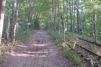
9 Railroad Right of Way through Seabrook Left: Section from Library south to Cain s Pond relatively clear Right: Section from Library North to Railroad Avenue partially overgrown, but substantially clear


10 Railroad Right of Way through Seabrook Left: Section south of Cain s Pond is overgrown Right: Section approaching Route 286 subsidence and overgrowth


11 Railroad Right of Way through Seabrook Historic artifacts of the Eastern RR can be basis for interpretive signs
12 NHSG Community Benefit Model Transportation Recreation Economic Development Whole (NHSG) Community Environment Public Safety Public Health Education Workman Management Consulting
13 USDOT/EPA/HUD Livability Principles 1. Promote more transportation choices 2. Promote equitable, affordable housing 3. Enhance economic competitiveness 4. Support existing communities 5. Coordinate policies and leverage investment 6. Value communities and neighborhoods
14 Anticipated Challenges Alternative Routing at Seabrook Station Erosion and vandalism at Cain s Mill Pond Walton Road bridge removal Funding for trail development in a tough economy
15 Resources for Trail Development Federal Funding Transportation funding (Transp Enhancements, Rec Trails) Other federal sources (CDBG, LWCF) State Funding Municipal Private Section Cash Contributions Private Sector In-Kind (labor, equipment, discounted materials)* (note that match eligibility of in-kind items varies by federal funding program)
16 Seabrook Rail Trail Implementation Next Steps Fall 2010-Winter 2011 Develop trail management agreement between NHDOT and Town of Seabrook Refine cost estimates, outreach materials and presentation for potential funders Outreach to potential funders/supporters Continue to build volunteer base of SRTA Build toward Transportation Enhancement funding proposal for summer 2011
17 NHSG Planning & Implementation Some lessons learned so far Develop and nurture a broad coalition Foster regional coordination Identify and cultivate local champions Make use of models in neighboring areas Draw on available technical assistance sources: RPCs, ECGA, RTC, NPS Don t underestimate community resources
18
19 Cost & Return on Investment Common cost range from $400K-$1M/mile depending on materials and design if using federal funding. Other trails in NH have realized lower costs, still with high quality trail, with private sector funding. Projected usage range of 325/day to 4,754/day based on NCHRP model (lower end likely, though this excludes tourism visitors) Estimated return on investment of $240K/year to $3.6M/year based on NCHRP model


20 NH Seacoast Greenway Presentation Overview Planning process and regional context Trail development opportunity in Seabrook Benefits, challenges, resources for trail development Next steps Some lessons learned
21 Conceptual Design for Trail

22 NHSG Interpretive Kiosks Standard timber-frame design used elsewhere on ECG Interpretive content to include info on NHSG on-road and planned off-road routes, ECG, road rules, host site info Maintenance agreements for kiosks along the on-road route are being developed between NHSG, NH State Parks, Strawbery Banke Museum. The trail crossing by the Seabrook public library would also be a good location for a kiosk.
4.19 Parks, Recreation, and Conservation Lands
 interchange would have on the Reed Paige Clark Homestead located on the north side of Stonehenge Road. Alternative D would also affect Palmer Homestead, E.F. Adams House, and Knapp Brothers Shoe Manufacturing
DRAFT - APRIL 13, 2007 ROUTING STUDY FOR TRAIL CONNECTIONS BETWEEN CALAIS AND AYERS JUNCTION
 DRAFT - APRIL 13, 2007 ROUTING STUDY FOR TRAIL CONNECTIONS BETWEEN CALAIS AND AYERS JUNCTION Abstract The vision for the East Coast Greenway is an off-road urban trail system running from Calais, Maine
Fred Milch Project Review Manager East Central Florida Regional Planning Council
 RESHAPING THE ROLE OF PARKS, RECREATIONAL AREAS, AND GREEN SPACE TO ENHANCE LIVABILITY Fred Milch Project Review Manager East Central Florida Regional Planning Council St. Johns River to Sea Loop Webinar
Chapter 6: POLICY AND PROCEDURE RECOMMENDATIONS
 Chapter 6 POLICY AND PROCEDURE RECOMMENDATIONS FOR SRRA Below are seven policy elements that should be considered for adoption by the Southwest Regional Recreation Authority of Virginia: 1. Develop strategies
Georgetown-Lewes Rail/Trail Study. Rail/Trail Study: Cool Spring to Cape Henlopen State Park New Road Extension (House Resolution No.
 Georgetown-Lewes Rail/Trail Study Rail/Trail Study: Cool Spring to Cape Henlopen State Park New Road Extension (House Resolution No. 47) August 22, 2011 Presentation Outline Background Benefits Statewide
Appalachian Trail Community
 Harpers Ferry, West Virginia Appalachian Trail Community A Designation Program of the Appalachian Trail Conservancy The Appalachian Trail Conservancy (ATC) mission is to preserve and manage the Appalachian
Business Item No
 Metropolitan Parks and Open Space Commission Meeting date: February 6, 2018 For the Community Development Committee meeting of February 20, 2018 For the Metropolitan Council meeting of February 28, 2018
Coast to Coast Connector Summit
 Project Partners Welcome to the Coast to Coast Connector Summit Winter Garden, Florida City Hall October 1, 2014 1 Why are we here? Objectives 1. Inform key stakeholders on the current state of the C2C
Making a River Segment Family and People Friendly: A Case Study of the Pemi River in the Plymouth Region
 Making a River Segment Family and People Friendly: A Case Study of the Pemi River in the Plymouth Region Kenneth Evans, Plymouth Rotary Club Patrick Hummel, DIvision of Parks & Recreation; Larry Spencer,
Committee Report. Community Development Committee For the Metropolitan Council meeting of April 13, Business Item No.
 Committee Report Business Item No. 2016-48 Community Development Committee For the Metropolitan Council meeting of April 13, 2016 Subject: Harriet Island-South St. Paul Regional Trail Master Plan, Saint
Section II. Planning & Public Process Planning for the Baker/Carver Regional Trail began in 2010 as a City of Minnetrista initiative.
 Section II Planning & Public Process Planning for the began in 2010 as a City of initiative. city staff began discussions with the Park District on the possibility of a north/south regional trail connection
When the trail took off over ten years ago, no one could have imagined the holistic benefits across North and South Carolina since then, or the
 When the trail took off over ten years ago, no one could have imagined the holistic benefits across North and South Carolina since then, or the wholehearted community engagement. It is a brilliant system
City Council Workshop July 26, 2010
 Des Moines Trails Connecting a Community City Council Workshop July 26, 2010 1 OVERVIEW Trail Benefits Trails Progress How We Fund Trails What s Next for Trails 2 What is a trail? Paved Trails 10 wide
Waukee Trailhead Public Art and Amenities Project
 Waukee - Trailhead Public Art and Amenities Project Sponsor Waukee Project Title Waukee Trailhead Public Art and Amenities Project Termini Description ( i.e. Park Avenue to 19th Street) NE Intersection
Exploring State Water Trail Programs
 National Park Service U.S. Department of the Interior Rivers, Trails, and Conservation Assistance Program Exploring State Water Trail Programs Barbara Nelson- Jameson Corita Waters Jessie Egan E X P E
MPRB: Southwest LRT Community Advisory Committee Issues and Outcomes by Location Current to: 12 November 2010
 MPRB: Southwest LRT Community Advisory Committee Issues and Outcomes by Location Current to: 12 November 2010 This is a compilation of issues and outcomes identified by the CAC. It is a work in progress,
Florida National Scenic Trail 5-Year Strategic Plan. Barbara Bowen
 Florida National Scenic Trail 5-Year Strategic Plan 2012 Barbara Bowen Florida National Scenic Trail M. Timothy O Keefe M. Timothy O Keefe Mike Knox 20-mile Planning Corridor Florida National Scenic Trail
Public Informational Meeting
 Public Informational Meeting April 17, 2007 Bow-Concord I-93 I Transportation Planning Study Bow-Concord Interstate 93 Transportation Planning Study Context Sensitive Solutions Planning Steps Screen Alternatives
ALBANY-HUDSON ELECTRIC TRAIL FEASIBILITY STUDY. Final Report OCTOBER 2011
 ALBANY-HUDSON ELECTRIC TRAIL FEASIBILITY STUDY Final Report OCTOBER 2011 ALBANY-HUDSON ELECTRIC TRAIL FEASIBILITY STUDY Prepared for: Town of East Greenbush 225 Columbia Turnpike Rensselaer, New York 12144
Creative Economy Plan
 Overview: Downtown Brampton HACE Creative Economy Plan 2011-2016 i Prepared for: HACE Creative Economy Round Table?. o m Presented by: Dennis Cutajar on behalf k fl> of the Creative Economy (HACE) Project
Draft for approval by TCC on 2/3, TAQC on 2/9 and ARC Board on 2/22. Regional Trail Plan. Mike Alexander, Director, Center for Livable Communities
 DATE: February 3, 2017 ISSUE SUMMARY: Regional Trail Plan FROM: Mike Alexander, Director, Center for Livable Communities IMPORTANCE: In May 2016, ARC adopted the active transportation component of the
$866,000. $1,400,000 Health Benefits $13,156,000 TOTAL ANNUAL DIRECT BENEFITS. $10,890,000 Economic Benefits
 SINGING RIVER TRAIL Trails Create Value + Generate Economic Activity Trails generate economic returns through improved health, safety, and environmental conditions, raise property values, and attract visitors.
TRAIL ANNUAL REPORT
 TRAIL ANNUAL REPORT 2016-17 Identify Undeveloped projects identified in the City s Greenprint or trail database 15.90 miles Study Projects that have been or are currently being studied to determine a feasible
GrandWalk Trail. Planning & Development Study Kent County, MI
 Urban & Regional Planning Program Michigan State University UP 494/894 Planning Practicum GrandWalk Trail Planning & Development Study Kent County, MI Nicole Carson, Bianca Cobarzan, Andrea Dewey, Lisa
LOCAL PLAN FOR THE MANAGEMENT OF THE APPALACHIAN TRAIL IN MAINE. (GRAFTON NOTCH TO KATAHDIN) 1 January 2013 (Revised 5 February 2014)
 1 January 2013 (Revised 5 February 2014)") LOCAL PLAN FOR THE MANAGEMENT OF THE APPALACHIAN TRAIL IN MAINE (GRAFTON NOTCH TO KATAHDIN) 1 January 2013 (Revised 5 February 2014) The Appalachian Trail is a way, continuous from Katahdin in Maine to
LOCAL PLAN FOR THE MANAGEMENT OF THE APPALACHIAN TRAIL IN MAINE (GRAFTON NOTCH TO KATAHDIN) 1 January 2013 (Revised 5 February 2014) The Appalachian Trail is a way, continuous from Katahdin in Maine to
The Vision for the San Juan Islands Scenic Byway
 The Vision for the San Juan Islands Scenic Byway 2 Judd Cove, Orcas Island, Courtesy of Kurt Thorson (kurtthorson.com) and San Juan County Land Bank Vision for the San Juan Islands Scenic Byway The San
Regional Wayfinding Sign Strategy Thurston County Trails 2017
 Regional Wayfinding Sign Strategy Thurston County Trails 2017 Partners: Members and partnering organizations of the Thurston Thrives Community Design Action Team City of Lacey, City of Olympia, City of
The following trails completed their work utilizing funds awarded by the Greenways Foundation:
 The Greenways Foundation Grant Awards 2013 and 2014 Our grant program has been in place since 2012 and is funded entirely by the proceeds received through our Indiana BMV specialty license plate. Please
Assessing Your Trails, Keeping Them Safe and Enjoyable
 Jon Wood, PLA, ASLA Associate Vice President Stewart Bert Lynn, PLA, ASLA, LEED AP Project Manager Mecklenburg County Asset and Facility Management Assessing Your Trails, Keeping Them Safe and Enjoyable
Meeting Report. Listening Session for Greenways + Blueways May 27, LaPorte County Solid Waste & Water Conservation Office, 6:00 8:00
 May 27, 2015 LaPorte County Solid Waste & Water Conservation Office, 6:00 8:00 Of the three meeting participants, two filled out the participant survey. The demographic results were as follows: o Caucasian:
Greater Minnesota Regional Parks and Trails Commission Designation Application
 Greater Minnesota Regional Parks and Trails Commission Designation Application General Section Designation Application #: 15-050D Date Submitted: 06/30/2015 Park or Trail Name: Perham to Pelican Rapids
10/25/2013. What is the SCORP?! 2013 Local Government Survey 2013 Statewide Public Survey Advisory Group Priority Areas Your Suggestions!
 COLORADO OUTDOOR RECREATION TRENDS RESULTS FROM THE SCORP AND STATEWIDE Colorado Outdoor Recreation Resource Partnership September 2013 PRESENTATION What is the SCORP?! 2013 Local Government Survey 2013
PARKLAND COUNTY TOURISM ACTION PLAN
 PARKLAND COUNTY TOURISM ACTION PLAN 2018-2020 CONTENTS Introduction............................................... 05 Organizational Alignment.................................. 07 Action Plan Development..................................
Project Planning, Compliance, and Funding
 Project Planning, Compliance, and Funding The plans above offer high level guidance to ensure that the A.T. is managed effectively as a whole unit in a decentralized management structure. Cooperative management
Mohawk Hudson Bike Hike Trail Crossroad Connection Study
 Summary Report - April 21, 2003 Mohawk Hudson Bike Hike Trail Crossroad Connection Study Summary Report Introduction The Capital District Transportation Committee (CDTC), in partnership with Albany County,
OR MISSION TRAIL ELEMENTARY
 Leawood: overview OVERLAD PARK 24: p.70 I-LA PARK 32: p.72 TOMAHAWK PARK 23: p.69 31: p.71 GEZER PARK OR MISSIO TRAIL ELEMETARY 22: p.68 W 133rd St W 135th St KASAS CITY MO - other segments Beginning/end
Annual Report Asociación Cívica de Nosara
 Annual Report Asociación Cívica de Nosara - 2018 LETTER FROM PRESIDENT Dear Members, As my second term as president of the Nosara Civic Association comes to an end, I look back and realize what an amazing
The Future of the Road to Revolutions. A Battle Road Scenic Byway Public Forum November 9, 2010
 The Future of the Road to Revolutions A Battle Road Scenic Byway Public Forum November 9, 2010 Who is the Battle Road Scenic Byway? Four Towns: Arlington, Lexington, Lincoln, Concord Minute Man National
A CASE FOR COMPLETING THE JORDAN RIVER PARKWAY: A
 A CASE FOR COMPLETING THE JORDAN RIVER PARKWAY: A safe crossing at 9000 South and 850 West Proposed 9000 South Underpass Parkway Timeline Parkway, Trail, and Tourism Facts Blueprint Jordan River 1971 1973
SECTION 106 ACTIVITIES ANNUAL REPORT
 SECTION 106 ACTIVITIES ANNUAL REPORT FOR THE YEAR ENDING DECEMBER 31, 2011 Metropolitan Washington Airports Authority 1593 Spring Hill Road, Suite 300 Vienna, Virginia 22182 JANUARY 2012 Introduction The
OPEN HOUSE PRESENTATION
 Thank You For Attending Today Capital District Transportation Committee Behan Planning and Design The Chazen Companies Engineering Sidekick Creative C onsultecon, Inc. R obert B engraff Drone Pilot What
Committee. Presentation Outline
 CW-33-15 11/9/2015 Community and Corporate Services Committee November 10, 2015 1 Presentation Outline Background Vision and Objectives Study Process and Timeline Public and Stakeholder Engagement Organization
The Recreational Trail along Cushing Park road has been a successful addition to the city
 The Recreational Trail along Cushing Park road has been a successful addition to the city Trails TRAILS, PATHS, ROUTES AND CONNECTORS Citizen input pointed to trails, paths, bike routes, and other non-motorized
Nov 21, 2014: The crash heard around the region
 Nov 21, 2014: The crash heard around the region Dec 2014: Our Katahdin forms to catalyze small wins 1 st Project To decorate the Bandstand and storefronts in Millinocket in time for the holidays Local
Economic Development and Tourism
 SECTION 4 SECTION 4 Economic Development and Tourism 4. Economic Development and Tourism Tourism plays a very important role in Niagara s economy, providing employment and generating business for support
Resort Municipality Initiative Annual Report 2015
 Resort Municipality Initiative Annual Report 2015 Submitted by: City of Rossland in association with Tourism Rossland Prepared by: Deanne Steven Acknowledgements The City of Rossland would like to thank
Colorado Springs & Pikes Peak Region Destination Master Plan
 Colorado Springs & Pikes Peak Region Destination Master Plan Overview June 19, 2018 DESTINATION MASTER PLAN What is Destination Master Planning? Focus on infrastructure, facilities, services, attractions
2014 STATEWIDE COMPREHENSIVE OUTDOOR RECREATION PLAN
 2014 STATEWIDE COMPREHENSIVE OUTDOOR RECREATION PLAN SUSTAINING COLORADO S OUTDOOR RECREATION FUTURE SECTION 1: INTRODUCTORY INFORMATION WHAT IS THE SCORP? The SCORP update is required every five years
WATERFRONT PROGRAM PROGRESS REPORT
 WATERFRONT PROGRAM PROGRESS REPORT 2016 (April - June) Highlights from 2016 In April, released the Supplemental Draft Environmental Impact Statement (EIS) for the Alaskan Way, Promenade, and Overlook Walk.
Aviation, Rail, & Trucking 6-1
 6-1 This chapter describes the services, facilities, and condition of air, rail, and trucking as components of the transportation system. These three intermodal areas have an impact on the factors to be
Connecting Nevada Partners The Connecting Nevada Stakeholders that participated in this effort are listed below in alphabetical order.
 Acknowledgements The Connecting Nevada project would not have been possible without the guidance and input of a number of stakeholders who demonstrate a commitment to making Nevada s transportation system
MEDIUM SIZE STADIUM STRATEGY
 MEDIUM SIZE STADIUM STRATEGY Approved by City Council on March 12, 2014 This plan is available online at www.edmonton.ca I. Executive Summary... 4 II. Medium Size Stadium Strategy... 5 1. Background...
Community Development Committee
 C Community Development Committee For the Metropolitan Council meeting of October 31, 2012 Committee Report Item:2012-316 ADVISORY INFORMATION October 16, 2012 Date Prepared: Subject: Intercity Regional
Fields of Gold Shenandoah Valley Agritourism Initiative
 Fields of Gold Shenandoah Valley Agritourism Initiative Program Overview Fields of Gold is a collaborative regional project to promote agritourism, involving six counties and five cities in the Shenandoah
CITY COUNCIL AGENDA MEMORANDUM
 To: Mayor and City Council From: Charles Ozaki, City and County Manager Prepared By: Kevin Standbridge, Deputy City and County Manager Katie Allen, City and County Engineer David Shinneman, Community Development
Trail # NW Tuesday, June DESIGN. Provide an Review the Provide an. Project Goals: System system. wayfinding
 I. Welcome / Introductions Bethany Creek Trail #2 Segment 3 Neighborhood Meeting #1 Bethany Presbyterian Church 15505 NW Springville Road, Portland, OR 97229 Tuesday, June 26, 2018 @ 6:00PM Meeting Minutes
LUDLAM TRAIL CORRIDOR DISTRICT
 1 APPLICATION NO. 9 MAY 2015 CDMP CYCLE LUDLAM TRAIL CORRIDOR DISTRICT PLANNING ADVISORY BOARD November 2, 2015 BACKGROUND 2 Staff Application Former Florida East Coast railroad corridor (privately owned)
Typical Conditions Along Cross-section E1 Typical Conditions Along Cross-section F
 Cross-section E: Cross-section E occurs where there are railroad ties that need to be removed. At some locations ties and rail are recommended to be removed (E1). This occurs for 8% of the corridor, or
4. Historic Resources
 4. Historic Resources Introduction Seabrook was historically a rural community of small villages, agricultural areas, extensive salt marshes and a major beach area. The boundaries of the present town were
Sign Library. Florida Trail Association
 310: FTA SIGN LIBRARY December 2015 Sign Library Florida Trail Association Trail signs are used to inform the motoring public and/or trail users that they are approaching, or are on, the Trail. When blazes
Preserving Route 66: Economic & Cultural Benefits
 Preserving Route 66: Economic & Cultural Benefits Tulsa, Oklahoma AMY WEBB JUNE 14, 2016 Tourism is Big Business Generated $2.1 trillion in spending in the U.S. in 2015 One in 9 American jobs is directly
APPENDIX OFFICIAL MAP ORDINANCE OF HAMILTONBAN TOWNSHIP OFFICIAL MAP NARRATIVE
 APPENDIX A OFFICIAL MAP ORDINANCE OF HAMILTONBAN TOWNSHIP OFFICIAL MAP NARRATIVE INTRODUCTION: The Official Map of Hamiltonban Township has been prepared to identify those lands and features that Hamiltonban
Auburn Trail / Ontario Pathways Trail Connector Feasibility Study Public Information Meeting Wednesday, August 22, 2012
 Auburn Trail / Ontario Pathways Trail Connector Feasibility Study Public Information Meeting Wednesday, August 22, 2012 Purpose of Feasibility Study Purpose Evaluate the feasibility of constructing a multiuse
The St Joe Compan November 2009
 The St. Joe Company November 2009 Forward Looking Statements e ts This presentation contains forward-looking statements about future events that are subject to numerous assumptions, risks and uncertainties.
PROGRESS REPORT WATERFRONT PROGRAM. Q (January - March) Highlights from Q1 2018
 Highlights from Q1 2018") WATERFRONT PROGRAM PROGRESS REPORT Q1 2018 (January - March) Highlights from Q1 2018 Advanced Pier 62 Rebuild construction including completion of Pier 62 demolition in February 2018. Prepared for the
WATERFRONT PROGRAM PROGRESS REPORT Q1 2018 (January - March) Highlights from Q1 2018 Advanced Pier 62 Rebuild construction including completion of Pier 62 demolition in February 2018. Prepared for the
Shelf Road Recreation Area 2015 BLM Annual Report of Rocky Mountain Field Institute Stewardship Under BLM Agreement L12AC20483 November 19, 2015
 Summary Shelf Road Recreation Area 2015 BLM Annual Report of Rocky Mountain Field Institute Stewardship Under BLM Agreement L12AC20483 November 19, 2015 Managed by the BLM Royal Gorge Field Office, Shelf
This page has been intentionally left blank.
 This page has been intentionally left blank. Chapter 2 2-2 2. Growing the Economy In many ways, the Niagara Region is a community of communities and this is becoming increasingly so. It is made up of towns
CHAPTER 4 -- THE LAND USE PLAN: DESCRIPTIONS AND POLICIES FOR THIRTEEN PLANNING AREAS
 CHAPTER 4 -- THE LAND USE PLAN: DESCRIPTIONS AND POLICIES FOR THIRTEEN PLANNING AREAS NORTH CENTRAL CAC AREA LITTLE VALLEY ROAD TO JUG HANDLE CREEK PLANNING AREA This planning area includes Cleone, Noyo,
The Atlanta BeltLine. & Sustainable Development GAFM Conferance. // March 25, 2014
 The Atlanta BeltLine & Sustainable Development GAFM Conferance // March 25, 2014 04/22/2014 Atlanta BeltLine // 2013 Page 1 // Organizational Structure Project Owner and Sponsor Redevelopment Authority
2. Goals and Policies. The following are the adopted Parks and Trails Goals for Stillwater Township:
 D. PARKS AND TRAILS 1. Introduction Stillwater Township s population is relatively low, with most residents living on rural residences on large lots. The need for active park space has been minimal in
Segment 2: La Crescent to Miller s Corner
 goal of the USFWS refuges is to conserve, protect and enhance fish, wildlife and plants and their habitats for the continuing benefit of the American people. Refuge lands are used largely for fishing,
Railroad Safety Trail
 2.1 INTRODUCTION AND PROJECT SETTING 2.1 Introduction & Project Setting Introduction This study is the result of a directed effort on the part of the City of San Luis Obispo to carry out previously established
COPPER HERITAGE TRAIL CONCEPTUAL PLAN 2011
 COPPER HERITAGE TRAIL CONCEPTUAL PLAN 2011 A Proposed 40 Mile Non-Motorized Rail Trail Route Connecting The Historic Communities Of the Copper Country Prepared For: Western Upper Peninsula Health Department
Roanoke River Rails-to-Trails, Incorporated. Annual Report 2005
 Roanoke River Rails-to-Trails, Incorporated Annual Report 2005 January 23, 2006 Roanoke River Rails-to-Trails, Inc. 2005 Annual Report Roanoke River Rails to Trails, Inc., a 501(c)(3) tax-exempt Virginia
Recreation and Park Commission, Capital Committee
 DATE: March 7, 2018 TO: THRU: FROM: RE: Recreation and Park Commission, Capital Committee Philip A. Ginsburg, General Manager Lisa Bransten, Director of Partnerships New Park at Francisco Reservoir Park
Park to Playa Trail. June 17, 2014
 Park to Playa Trail June 17, 2014 Representatives: Park to Playa Trail Karly Katona, Deputy for Sustainability & Economic Development, Office of Supervisor Mark Ridley-Thomas David McNeill, Executive Officer,
!" # $ % & % ' ( '' ) ) ) ) )
 ) ) ) )") !" #$% &% ' ( ')) ))) #% * % ) +#% *- *,% ) Trails Attract Business, Residents and Tourists National Association of Homebuilders 0% 20% 40% 60% % of What People Desired Exercise Facilities Proximity to
!" #$% &% ' ( ')) ))) #% * % ) +#% *- *,% ) Trails Attract Business, Residents and Tourists National Association of Homebuilders 0% 20% 40% 60% % of What People Desired Exercise Facilities Proximity to
Crossroads of Europe 2013 Sara Gutiérrez.
 Crossroads of Europe 2013 Sara Gutiérrez CREATION OF THE NETWORK EARTH = European Alliance for Responsible Tourism and Hospitality Officially launched on October, 16 th of 2008 in Brussels, it aims at
To Whom It May Concern. Elizabeth Calcutt, Networks Northwest. Date: December 18, Request for Statements of Qualification
 Board Chair: Gary W. Fedus Chief Executive Officer: Matt McCauley To: From: To Whom It May Concern Elizabeth Calcutt, Networks Northwest Date: December 18, 2018 Re: Request for Statements of Qualification
PDAC Priority Project East Dayton Rails-to-Trails (Flight Line) Project Description
 Project Description") PDAC Priority Project East Dayton Rails-to-Trails (Flight Line) Project Description The Flight Line project represents an amazing opportunity to become a truly transformative urban recreational trail that
PDAC Priority Project East Dayton Rails-to-Trails (Flight Line) Project Description The Flight Line project represents an amazing opportunity to become a truly transformative urban recreational trail that
The St. Joe Company. Raymond James Institutional Investors Conference March 10, 2009
 The St. Joe Company Raymond James Institutional Investors Conference March 10, 2009 Forward Looking Statements This presentation contains forward-looking statements about future events that are subject
Kansas (KAW) River History
 River History") Kansas (KAW) River History The first map of the Kansas River is dated back to 1718. Lewis and Clark spent 3 days camped at Kaw Point at the confluence of the Kansas and Missouri Rivers. Kansas (KAW) River
Kansas (KAW) River History The first map of the Kansas River is dated back to 1718. Lewis and Clark spent 3 days camped at Kaw Point at the confluence of the Kansas and Missouri Rivers. Kansas (KAW) River
Village of Harrisville and Town of Diana
 Village of Harrisville and Town of Diana Resources are located between NYS DOT End Mile Point Lewis County Line 00.00-11.43 & St. Lawrence County 00.00-7.90 Joseph Bonaparte (former King of Spain and brother
Needham Heights Neighborhood Association February Rail Trail Overview
 Needham Heights Neighborhood Association February 4 2013 Rail Trail Overview Stone Dust Path, Devils River WI Needham Rail Trail Greenway: Working with the town to assist, advise and coordinate rail trail
APPENDIX A: Survey Instruments
 Three different surveys were conducted during the research phase of the NCHA Trails Study. One questionnaire was designed for elected officials and user groups (general public). The other two questionnaires
COASTAL CONSERVANCY. Staff Recommendation September 22, 2011 BAY AREA RIDGE TRAIL: HOOD MOUNTAIN TO HIGHWAY 12
 COASTAL CONSERVANCY Staff Recommendation September 22, 2011 BAY AREA RIDGE TRAIL: HOOD MOUNTAIN TO HIGHWAY 12 File No. 11-039-001 Project Manager: Betsy Wilson RECOMMENDED ACTION: Authorization to disburse
MARTA & City of Atlanta Sales Tax Referendums. Public Hearings May 25 & 26, 2016 June 1 & 2, 2016
 MARTA & City of Atlanta Sales Tax Referendums 1 MARTA & City of Atlanta Sales Tax Referendums Public Hearings May 25 & 26, 2016 June 1 & 2, 2016 MARTA & City of Atlanta Sales Tax Referendums 2 Guiding
County of Peterborough Active Transportation Master Plan
 The TMP developed a conceptual AT/cycling network for Peterborough County that identified both on-road and off-road (trail) AT facilities. This was a coarse network based on the existing trails and off-road
CITY OF VAUGHAN EXTRACT FROM COUNCIL MEETING MINUTES OF OCTOBER 30, 2012
 CITY OF VAUGHAN EXTRACT FROM COUNCIL MEETING MINUTES OF OCTOBER 30, 2012 Item 36, Report No. 39, of the Committee of the Whole, which was adopted without amendment by the Council of the City of Vaughan
Victoria County Tourism Strategy Presentation to Municipal Council
 2017, Group ATN Consulting Inc. Victoria County Tourism Strategy Presentation to Municipal Council Delivered by Group ATN - Stephen Coyle & Thomas McGuire May 29, 2017 1 Benefits of a Tourism Strategy
Update on Trinity Trails. Presented by: Richard Zavala, Director Park and Recreation Department February 7, 2017
 Update on Trinity Trails Presented by: Richard Zavala, Director Park and Recreation Department February 7, 2017 Overview Provide review of trail planning and development along the main stem Trinity River
A1A North Corridor Multi-Use Trail. Vilano to Ponte Vedra Beach
 A1A North Corridor Multi-Use Trail Vilano to Ponte Vedra Beach The A1A North Corridor Community Area comprised of five unincorporated areas: Porpoise Point Vilano Beach Surfside Beach North Beach South
March 2, The Honorable Mayor Williams D. Sessoms, Jr. Members of City Council. Subject: Coastal CIP Presentation to City Council - March 6, 2018
 OFFICE OF THE CITY MANAGER (757) 385-4242 (757) 427-5626 FAX MUNICIPAL CENTER BUILDING 1, ROOM 234 2401 COURTHOUSE DRIVE VIRGINIA BEACH, VA 23456-9001 March 2, 2018 The Honorable Mayor Williams D. Sessoms,
AGENDA ITEM 5 D WAKULLA ENVIRONMENTAL INSTITUTE (WEI) TRAIL FEASIBILITY STUDY
 TRAIL FEASIBILITY STUDY") March 19, 2018 AGENDA ITEM 5 D WAKULLA ENVIRONMENTAL INSTITUTE (WEI) TRAIL FEASIBILITY STUDY TYPE OF ITEM: Action STATEMENT OF ISSUE The Wakulla Environmental Institute (WEI) Trail is one of several trails
March 19, 2018 AGENDA ITEM 5 D WAKULLA ENVIRONMENTAL INSTITUTE (WEI) TRAIL FEASIBILITY STUDY TYPE OF ITEM: Action STATEMENT OF ISSUE The Wakulla Environmental Institute (WEI) Trail is one of several trails
Planning Board Meeting Minutes.Approved. Aug 6, 2018
 APPROVED MEETING MINUTES TOWN OF WARNER PLANNING BOARD August 6, 2018 7:00 PM WARNER TOWN HALL - LOWER MEETING ROOM 5 East Main Street, Warner, NH 03278 OPEN MEETING ROLL CALL Present: Ben Frost (Chair),
DULLES AREA HIGHLIGHTS. Gary Garczynski Commonwealth Transportation Board Northern Virginia District. Committee for Dulles August 4, 2016
 DULLES AREA HIGHLIGHTS Gary Garczynski Commonwealth Transportation Board Northern Virginia District Committee for Dulles August 4, 2016 Smart Scale (formerly HB2) Overview Round 1 completed with the adoption
This section provides the basic information about the park or trail and the organizations responsible for it. Funding Application F
 General This section provides the basic information about the park or trail and the organizations responsible for it. Park/Trail ID # 16-43D Last Update July 13, 217 District 2 Funding Application 17-82-F
// LEARN // ENGAGE // VOLUNTEER // DONATE // PROJECT OVERVIEW MAP
 // LEARN // ENGAGE // VOLUNTEER // DONATE // PROJECT OVERVIEW MAP PROJECT OVERVIEW MAP The Atlanta BeltLine is a dynamic and transformative project for Atlanta. Through the development of a new transit
Welcome to the Cross County Trail Public Input Session!
 Welcome to the Cross County Trail Public Input Session! Please sign in on the table below! What are we doing here? Camden County has proposed a bicycle and pedestrian trail spanning across the entire county.
BUCKS COUNTY TRAILS. September 10, 2015 Presentation to:
 BUCKS COUNTY TRAILS September 10, 2015 Presentation to: BUCKS COUNTY TRAILS Benefits of Trails Bucks County Trails The Circuit Active Trail Projects Planning Studies Municipal Trails Planning Other Trail