Kansas (KAW) River History
|
|
|
- Lynne Riley
- 5 years ago
- Views:
Transcription
1


2 Kansas (KAW) River History The first map of the Kansas River is dated back to Lewis and Clark spent 3 days camped at Kaw Point at the confluence of the Kansas and Missouri Rivers.

3 Kansas (KAW) River History The Kaw was declared a navigable river in 1857 by the Kansas Legislature to encourage navigation. The legislature repealed this law in 1864 at the encouragement of the railroad to reduce competition. The river was restored to navigable status by the legislature in 1913.


4 Kansas (KAW) River History The Kaw has long been known for it s fishing and recreational opportunities. Public access ramps for boat and canoe use were first funded by the state in the 1970 s.
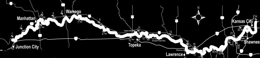
5 Background There are only three navigable rivers in Kansas (Kansas, Ark & Missouri). All other streams are private in Kansas. Kansas River is approximately174 miles long, extending from Junction City to Kansas City. A few access sites were constructed in the 1970 s and early 1980 s on the Kansas River. Renewed interest in the 1990 s, Kansas River Recreation plan was developed in Goal was to place access every miles. In 2000, there were only 5 public access sites.
6 Background Cont. Over $1,000,000 has been committed by KDWPT to develop access since Local funds and donations have probably equaled this amount. An additional 14 access sites have been constructed.
7 Background Cont. KDWPT was contacted in 2011 about potential projects that would fall within the America s Great Outdoors program. The Kansas River water trail project was identified as a potential project for this program. In 2011 KDWPT, in conjunction with the National Parks Service, started the process to apply for the Kansas River to be included in the new National Water Trail program.


8 Kansas River was dedicated as a National Water Trail in Dedication River Tour

9 Items were identified as needed to improve the water trail. Path finding signs. Brochures Website River navigation signs Kiosks

10 Path Finding Signs Signs are in place directing people to all 19 access sites. Thanks to KDOT for assisting.
11 Brochure Development Brochures and website were developed with funding from a NPS grant.

12 Web site development There is also a National Water Trail site maintained by NPS

13 River Navigation Signage Placed every two miles for safety and river user reference.

14 Kiosk Project Kiosks to be placed at each access site to provide information to river users and give community historical and tourism info.

15 Kiosk Structure at Lecompton

16 Westar Green Team donates materials and installation.


17 Eudora access site upgrades & Governor float trip.

18 Current Kansas River Sites 19 sites currently open to public access.

19 AREAS OF NEED No access currently available between Topeka and Belvue (29 miles).
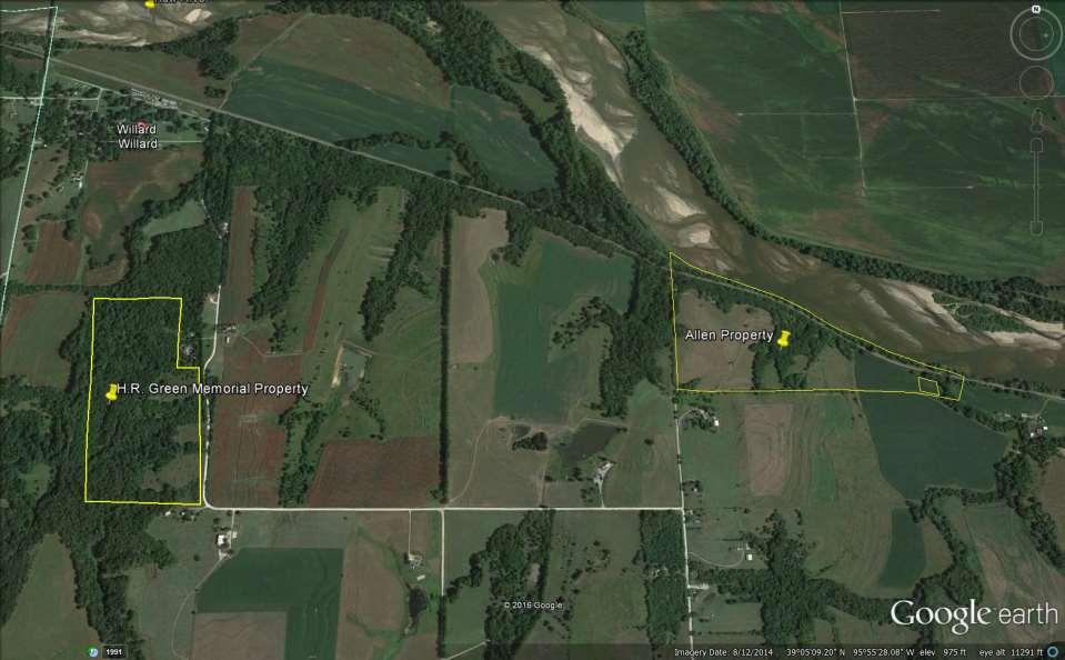
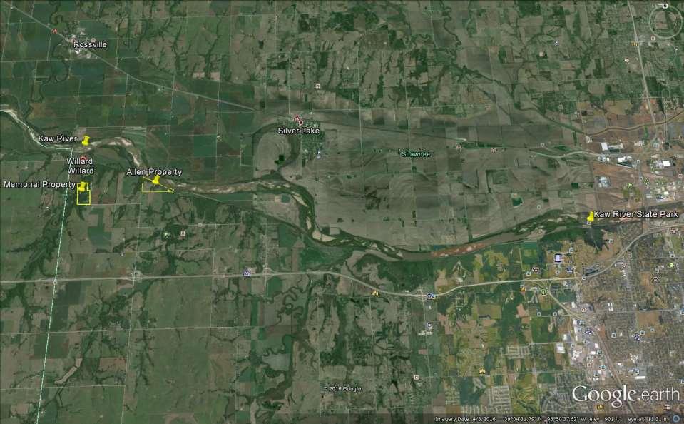
20 Projects in Progress Working with Rossville, Shawnee County and an adjacent landowners to get two access sites along 29 mile stretch. Involved with Topeka & River Front Authority on Topeka Weir upgrade project.

21 Topeka Weir upgrade

22 Topeka Weir upgrade

23 Topeka Weir upgrade

24 Air Boat purchases for patrol and rescue
25 How Are We Moving Forward Potential property purchases along river for river access, and establishing new State Park Utilizing existing properties for a State Park Utilizing grants for development (Trail Grants, LWCF, & MBA) Partnering with local communities and interest groups (Pottawattamie Tribal Nation) Working with local landowners
26

27 H.R. Green Memorial Property
28 H.R. Green Memorial Property Green property is currently managed by our Public Lands Division (Deed will transfer to Parks July 2016) Under current donation provisions, only nonconsumptive activities permitted Existing 3 mile multi-use trail Historically rich, many interpretative opportunities Donation provisions will allow development and improvements (Campgrounds, Cabins, Trails)

29 Allen Property
30 Allen Property 550 acres of potential land available for purchase 80 acres optimal for State Park development and river access (Under Legislative Restrictions) Construction of 5 modern cabins, 15 site full hookup campground, hike/bike-in camping, and multi-use trail system Property would provide ¾ mile of river front

31 Allen State Park Plan

32 Vassar Creek and Kaw Access
33
34


35 Special Thanks
Camping (Primitive) Camping (RV) Electrical Potable Water Grill Established Fire Pit Picnic Table
 Camping (RV) Electrical Potable Water Grill Established Fire Pit Picnic Table") Alden - 9th Road River Mile 777 Map: 38.20833, -98.32031 Managing Agency: Kansas Department of Wildlife, Parks & Tourism Nearest Community: Alden, Rice County Kansas Developed Amenities Provided Parking
Alden - 9th Road River Mile 777 Map: 38.20833, -98.32031 Managing Agency: Kansas Department of Wildlife, Parks & Tourism Nearest Community: Alden, Rice County Kansas Developed Amenities Provided Parking
MASTER PLAN EXECUTIVE SUMMARY
 Biscuit Run State Park Scottsville Road (State Route 20) Charlottesville, VA 22902 Biscuit Run State Park MASTER PLAN EXECUTIVE SUMMARY Department of Conservation and Recreation Division of Planning and
City of Chelan Shoreline Public Access Plan
 City of Shoreline Public Access Plan This City of Shoreline Public Access Plan documents how the City has planned for parks and recreation in the community, particularly along Lake and the River. This
Meshach Browning Trail System at the Deep Creek Lake Lion s Club Park on Bumble Bee Rd.
 Meshach Browning Trail System at the Deep Creek Lake Lion s Club Park on Bumble Bee Rd. The Meshach Browning trail system will be a public, non-motorized, multi-use (running, dog-walking, cross country
Nez Perce National Historic Trail. Land and Water Conservation Fund FY2014 Request
 FY2014 Request National Trails System FY2014 Total LWCF Request: $2,840,000 Project Name Agency District # Tracts Acres Total Cost Cow Island and Cow Creek BLM MT-1 2 779 $1,600,000 (in conjunction with
Making a River Segment Family and People Friendly: A Case Study of the Pemi River in the Plymouth Region
 Making a River Segment Family and People Friendly: A Case Study of the Pemi River in the Plymouth Region Kenneth Evans, Plymouth Rotary Club Patrick Hummel, DIvision of Parks & Recreation; Larry Spencer,
Blueways: Rivers, lakes, or streams with public access for recreation that includes fishing, nature observation, and opportunities for boating.
 Parks, Open Space and Trails PRINCE WILLIAM COUNTY 2008 COMPREHENSIVE PLAN TRAILS PLAN CONTENTS The components of the trails plan are: Intent Definitions Goals, Policies, and Action Strategies Trails Map
OR MISSION TRAIL ELEMENTARY
 Leawood: overview OVERLAD PARK 24: p.70 I-LA PARK 32: p.72 TOMAHAWK PARK 23: p.69 31: p.71 GEZER PARK OR MISSIO TRAIL ELEMETARY 22: p.68 W 133rd St W 135th St KASAS CITY MO - other segments Beginning/end
B10. Agate Beach State Recreation Site
 B10. Agate Beach State Recreation Site Location Within the City of Newport, just south of the Yaquina Head Outstanding Natural Area. The park is located along the west side of Highway 101 at the mouth
Department of Environment, Climate Change & Water NSW. Stakeholder feedback
 Department of Environment, Climate Change & Water NSW Stakeholder feedback 1 Stakeholders group Blue Gum High Forest Group Guardians of Lane Cove NP Sydney Metropolitan Wildlife Service Ku-ring-gai Historical
2009 RIVER TOWN OF THE YEAR AWARD APPLICATION Supplemental Material Images
 2009 RIVER TOWN OF THE YEAR AWARD APPLICATION Supplemental Material Images Our History The earliest record of settlement along the river is in 1854; one of the earliest in Carroll County. About this time
Understanding the caring capacity of the visitor experience Provide facilities to support a high level user experience Address visual quality through
 Understanding the caring capacity of the visitor experience Provide facilities to support a high level user experience Address visual quality through recreation ecological restoration opportunities Collaboration
China Creek North Park Upgrades and Glen Pump Station. Park Board Committee Meeting Monday, July 10, 2017
 China Creek North Park Upgrades and Glen Pump Station Park Board Committee Meeting Monday, July 10, 2017 Purpose The purpose of this presentation is to: Share the results of the public engagement processes;
Draft Marine and Harbour Facilities Strategy
 Draft Marine and Harbour Facilities Strategy Vision The Coromandel peninsula is a destination of choice for safe, sustainable and accessible marine and harbour facilities that are fit for purpose to meet
Triangle Land Conservancy Conservation Area Monitoring Report Carolina North
 Triangle Land Conservancy Conservation Area Monitoring Report Carolina North Property Name: Bolin Creek East Conservation Area Date of visit: 4/8/2015 County: Orange Property Type: Restrictive Covenants
Recreation News. Welcome. Chris Jackson. In this Issue: O S U C o l l e ge F o r e s t s
 Recreation News O S U C o l l e ge F o r e s t s In this Issue: Welcome New tree identification posts... New Arboretum Trails New Interpretive Signs Ridge Trail Seasonal Closures Leave No Trace reminder
Triangle Land Conservancy Conservation Area Monitoring Report Carolina North
 Triangle Land Conservancy Conservation Area Monitoring Report Carolina North Property Name: Bolin Creek East Conservation Area Date of visit: March 16, 2017 County: Orange Property Type: Restrictive Covenants
Crystal Lake Area Trails
 Lake Area Trails Welcome to the Lake area of the Big Snowy Mountains! This island mountain range in central Montana features peaks reaching to 8,600 feet and long, high ridges from which vistas of the
Internship Announcement. Mount Rainier National Park. NPS Academy Internships 6 Positions. Please Respond By March 1, 2019
 NPS Academy Mount Rainier National Park Internship Announcement Mount Rainier National Park NPS Academy Internships 6 Positions Please Respond By March 1, 2019 The Northwest Youth Corps (NYC), in partnership
Tabor Mountain Recreation Society Who We Are What We Do Regional Park The Ask. Photo by Ken Hodges
 Tabor Mountain Recreation Society Who We Are What We Do Regional Park The Ask Photo by Ken Hodges 1 TMRS History 1961 logging and the Grove Fire activities resulted in many of the existing trails 1961
RECREATION MANAGEMENT PLAN WELLS HYDROELECTRIC PROJECT FERC NO. 2149
 RECREATION MANAGEMENT PLAN WELLS HYDROELECTRIC PROJECT FERC NO. 2149 May 2010 Prepared by: Public Utility District No. 1 of Douglas County Copyright 2010. Public Utility District No. 1 of Douglas County.
Fort Christanna Historical and Recreational Park
 Brunswick County, Virginia 2012 Virginia Association of Counties Achievement Award Submission Parks and Recreation Fort Christanna Historical and Recreational Park Brunswick County Fort Christanna Historical
P ARK I MPROVEMENTS 2013
 ANCHORAGE PARKS AND RECREATION PRESENTS... Fish Creek P ARK I MPROVEMENTS 2013 KIWANIS FISH CREEK PARK 3907 TURNAGAIN BLVD. E MARK MCCAFFERY, MUNICIPALITY OF ANCHORAGE PARKS & RECREATION DEPT. CONTACT:
Lawrence Loop SWOT Analysis
 Alignment: D1 (Map Color: Dark Blue) Description: This alignment connects to the north end of the Burroughs Creek Trail and continues along the west side of the Railroad to 8 th Street. Strengths: - This
Paiute Trail Hatfield-McCoy Highwood Mountains
 Paiute Trail Hatfield-McCoy Highwood Mountains Located in Central Utah Main trail is 238 miles 550 miles of designated side trails Links 16 communities in 4 counties Ranges from 5,200 to 11,500 feet Great
South Colony Basin Recreation Fee Proposal
 South Colony Basin Recreation Fee Proposal Purpose and Need for Collecting Fees in South Colony Basin: Forest Service appropriated funds have not been sufficient to maintain current recreational services
Village of Harrisville and Town of Diana
 Village of Harrisville and Town of Diana Resources are located between NYS DOT End Mile Point Lewis County Line 00.00-11.43 & St. Lawrence County 00.00-7.90 Joseph Bonaparte (former King of Spain and brother
Wind Turbines and Transmission Lines carry anxiety across the Hill Country
 Wind Turbines and Transmission Lines carry anxiety across the Hill Country by Vicki Wolf Once you ve visited Enchanted Rock, you never forget the scenic beauty and power of this natural wonder. What would
City Council Report 915 I Street, 1 st Floor Sacramento, CA
 City Council Report 915 I Street, 1 st Floor Sacramento, CA 95814 www.cityofsacramento.org File ID: 2017-01418 December 12, 2017 Consent Item 10 Title: Designating the Miller Regional Park Parking Lots
Acquisition in fee simple of approximately one-half acre of property on the shore of Spring Lake to expand the Lakeside Beach Park.
 Lakeside Beach TF00-136 $122,550.00 in fee simple of approximately one-half acre of property on the shore of Spring Lake to exp the Lakeside Beach. 2000 River Ravines TF00-150 $910,000.00 in fee simple
Section XIII. Cost Estimates
 Section XIII Cost Estimates 13-01. INTRODUCTION SECTION XIII COST ESTIMATES a. General. Preliminary cost estimates for development of proposed new and renovation or replacement actions at Lake Shelbyville
Colorado s Instream Flow Program at 40. Celebrating 40 Years of Success and Challenges January 15, 2014 Denver, Colorado
 Colorado s Instream Flow Program at 40 Celebrating 40 Years of Success and Challenges January 15, 2014 Denver, Colorado ISF Program established in 1973 by Senate Bill 97 Recognized the need to correlate
Glacial Lakes State Park Management Plan Amendment Camper Cabin Development
 Glacial Lakes State Park Management Plan Amendment Camper Cabin Development Minnesota Department of Natural Resources Division of Parks and Recreation November 2006 Glacial Lakes State Park Management
Environment and Natural Resources Trust Fund 2019 Request for Proposals (RFP)
") Environment and Natural Resources Trust Fund 2019 Request for Proposals (RFP) Project Title: Glacial Edge Trail and Downtown Pedestrian Bridge Category: G. Land Acquisition for Habitat and Recreation ENRTF
Environment and Natural Resources Trust Fund 2019 Request for Proposals (RFP) Project Title: Glacial Edge Trail and Downtown Pedestrian Bridge Category: G. Land Acquisition for Habitat and Recreation ENRTF
Exploring State Water Trail Programs
 National Park Service U.S. Department of the Interior Rivers, Trails, and Conservation Assistance Program Exploring State Water Trail Programs Barbara Nelson- Jameson Corita Waters Jessie Egan E X P E
2. Goals and Policies. The following are the adopted Parks and Trails Goals for Stillwater Township:
 D. PARKS AND TRAILS 1. Introduction Stillwater Township s population is relatively low, with most residents living on rural residences on large lots. The need for active park space has been minimal in
Hillsborough County Florida Hillsborough County s Trailways Addressing Program
 Hillsborough County Florida Hillsborough County s 9-1-1 Trailways Addressing Program 2010 ProBike/ProWalk Florida -Conference May 12-13, 2010 1 REQUEST Staff from the Hillsborough County Sheriff s Office
Internship Announcement. Mount Rainier National Park. NPS Academy Internships 6 Positions. Please Respond By April 15, 2019
 NPS Academy Mount Rainier National Park Internship Announcement Mount Rainier National Park NPS Academy Internships 6 Positions Please Respond By April 15, 2019 The Northwest Youth Corps (NYC), in partnership
Dungeness Recreation Area County Park Master Plan
 Dungeness Recreation Area County Park Public Outreach Meeting October 10, 2007 Project Overview USFWS Site Dungeness Recreation Area County Park Meeting Objectives: Re-Introduce project; provide status
Georgetown-Lewes Rail/Trail Study. Rail/Trail Study: Cool Spring to Cape Henlopen State Park New Road Extension (House Resolution No.
 Georgetown-Lewes Rail/Trail Study Rail/Trail Study: Cool Spring to Cape Henlopen State Park New Road Extension (House Resolution No. 47) August 22, 2011 Presentation Outline Background Benefits Statewide
ONONDAGA CREEKWALK PHASE II. Public Information Meeting Series 1
 ONONDAGA CREEKWALK PHASE II Public Information Meeting Series 1 Andrew Maxwell Director, Syracuse-Onondaga County Planning Agency Owen Kerney Assistant Director for City Planning Russell Houck, PE City
Tallahassee-St. Marks Historic Railroad Trail
 Revitalizing a Historic Trail Designated as a National Recreation Trail, the 16-mile Tallahassee-St. Marks Historic Railroad Trail has been enjoyed by countless bicyclists, runners, and outdoor enthusiasts
KDOT announces approved March bids
 IMMEDIATE RELEASE April 10, 2018 For more information: Kim Stich 785.296.3585 KDOT announces approved March bids The Kansas Department of Transportation announces approved bids for state highway construction
Chapter 6: POLICY AND PROCEDURE RECOMMENDATIONS
 Chapter 6 POLICY AND PROCEDURE RECOMMENDATIONS FOR SRRA Below are seven policy elements that should be considered for adoption by the Southwest Regional Recreation Authority of Virginia: 1. Develop strategies
Watchorn Provincial Park. Management Plan
 Watchorn Provincial Park Management Plan 2 Watchorn Provincial Park Table of Contents 1. Introduction... 3 2. Park History... 3 3. Park Attributes... 3 3.1 Natural... 4 3.2 Recreational... 4 3.3 Additional
Raytown: overview. map. Santa Fe, Oregon, and California National Historic Trails KANSAS CITY KANSAS CITY. 38 Trail alignments: Raytown.
 Raytown: overview Blue Ridge Cut-off map 18: p.42 RICE- TREMOTI HOME Raytown Tfwy KASAS 17: p.41 JUCTIO WITH ROCK ISLAD LIE RIGHT OF WAY 16: p.40 BUS STOP AT E 51ST AD BLUE RIDGE (KASAS ) Sterling Ave
Village of Stockholm
 Village of Stockholm 2016 Plan for the Community Park Park Committee: Harley Cochran Mark Coronna Steve Grams Jerry Larson Hap Palmberg FINAL: FOR VILLAGE BOARD APPROVAL March 8, 2016 1 Table of Contents
A BOAT RAMP TO NOWHERE
 A BOAT RAMP TO NOWHERE A PROPOSAL FOR ACCESS TO HARVIE PASSAGE A Presentation to the City of Calgary December 2017 Presented by: Peter Crowe-Swords Bow River Trout Foundation Background: The Bow River
Header i
 Header i 048285014.10 Header Sub Title Body Text here. Body text here. Body text here. Section 1... 1 Executive Summary... 1 Opportunities and Constraints... 3 Overall Opportunities and Constraints Map
Willamette River Water Trail Implementation Plan June 2004
 Willamette River Water Trail Implementation Plan June 2004 Prepared by the Willamette Restoration Initiative in cooperation with Summary The Willamette River Water Trail is an opportunity waiting to happen
MERIWETHER LEWIS SITE NATCHEZ TRACE PARKWAY
 MERIWETHER LEWIS SITE NATCHEZ TRACE PARKWAY In the life of every organization, company or family there are highs and lows. One of those highs in the history of Lewis & Clark Trail Heritage Foundation was
Conrad Historic Site Questionnaire Summary of Responses January 20 May 31, 2016
 Conrad Historic Site Questionnaire Summary of Responses January 20 May 31, 2016 In January, the consultant team, members of the Carcross/Tagish First Nation and the Conrad Steering Committee had an initial
Triangle Land Conservancy Conservation Area Monitoring Report Carolina North
 Triangle Land Conservancy Conservation Area Monitoring Report Carolina North Property Name: Bolin Creek West Conservation Area Date of visit: March 16, 2017 County: Orange Property Type: Restrictive Covenants
Directional Tourism Signage Programme Policies
 Directional Tourism Signage Programme Policies Introduction Directional tourism signage also known as a pay-to-play programme provides an opportunity for tourism attractions and tourism-based businesses
Harbourmaster s Office
 Harbourmaster s Office Recommendations That the Board: i. note the recent transfer of the harbourmaster department from Auckland Council to Auckland Transport. ii. note the roles and responsibilities of
Park-specific management and policies Wainuiomata Recreation Area
 Park-specific management and policies Wainuiomata Recreation Area 6.8 Wainuiomata Recreation Area 6.8.1 Legal status Title held: Legislative status: Wellington Regional Council Administered under Local
Kansas Trails News. Flint Hills Nature Trail construction moving forward. Rail-trail from Marysville, Kansas to Lincoln, Nebraska now Open!
 Kansas Trails News Sunflower Rail-Trails Conservancy 12/28/2015 Rail-trail from Marysville, Kansas to Lincoln, Nebraska now Open! The 19.5-mile Chief Standing Bear Trail which links Beatrice, Neb. to the
Triangle Land Conservancy Conservation Area Monitoring Report Carolina North
 Triangle Land Conservancy Conservation Area Monitoring Report Carolina North Property Name: Crow Branch Conservation Area Date of visit: March 16, 2016 County: Orange Property Type: Restrictive Covenants
IOW Ramblers Submission Paper to the Sept 2016 ROW Improvement Plan Consultation.
 IOW Ramblers Submission Paper to the Sept 2016 ROW Improvement Plan Consultation. The current Island Rights of Way Improvement Plan is a comprehensive document and much of its content is still relevant
Gardner: overview. Santa Fe, Oregon, and California National Historic Trails UNINCORPORATED JOHNSON COUNTY OLATHE UNINCORPORATED JOHNSON COUNTY
 Santa Fe, Oregon, and California ational Historic Trails : overview 99: p.134 100: p.135 GARDER JUCTIO 102: p.137 56: p.126 EDGERTO Burlington orthern Intermodal and Logistics 98: p.133 101: p.136 S Waverly
To protect and preserve the Kansas River
 September 2013 KANSAS RIVER CURRENTS To protect and preserve the Kansas River Lenexa Boy Scout float and clean up on July 27th, 2013. WaterOne Coffer Dam Cleanup on July 13th, 2013. Governor s River Recreation
Rogue River Access and Management Plan Draft Alternatives
 Rogue River Access and Management Plan Draft Alternatives The Rogue River Access and Management Plan was initiated in December, 2011 and is being led by Jackson County Parks (JCP) and Oregon Department
Multimodal Planning Studies
 Multimodal Planning Studies Commuter Park and Ride Study Steering Committee Meeting June 6, 2013 Agenda 1. Update on Project Schedule 2. Update on Online Interactive Mapping 3. Key Themes from the Open
Daisy Dean Trail 628/619 ATV Trail Construction
 Background and Purpose and Need The Daisy Dean ATV Trail Construction Project is located in the Little Belt Mountains, Musselshell Ranger District, Lewis and Clark National Forest approximately 32 miles
TWO NIGHT AGENDA. Wednesday Oct Big Ideas, Big Goals Who wants to eat the cake?
 TWO NIGHT AGENDA Wednesday Oct. 27 - Big Ideas, Big Goals Who wants to eat the cake? Survey and background info Case studies Promising projects Thursday Oct. 28 - Making it Real Who wants to help make
Regional Wayfinding Sign Strategy Thurston County Trails 2017
 Regional Wayfinding Sign Strategy Thurston County Trails 2017 Partners: Members and partnering organizations of the Thurston Thrives Community Design Action Team City of Lacey, City of Olympia, City of
DRAFT - APRIL 13, 2007 ROUTING STUDY FOR TRAIL CONNECTIONS BETWEEN CALAIS AND AYERS JUNCTION
 DRAFT - APRIL 13, 2007 ROUTING STUDY FOR TRAIL CONNECTIONS BETWEEN CALAIS AND AYERS JUNCTION Abstract The vision for the East Coast Greenway is an off-road urban trail system running from Calais, Maine
Cascade River State Park Management Plan Amendment
 This document is made available electronically by the Minnesota Legislative Reference Library as part of an ongoing digital archiving project. http://www.leg.state.mn.us/lrl/lrl.asp Cascade River State
The Winding Valley and the Craggy Hillside
 The Winding Valley and the Craggy Hillside A History of the City of Rosedale, Kansas by Margaret Landis. Copyright 1976. All attempts have been made to reproduce the spelling, capitalization and layout
WEKIVA WILD AND SCENIC RIVER ACT OF 2000
 PUBLIC LAW 106 299 OCT. 13, 2000 WEKIVA WILD AND SCENIC RIVER ACT OF 2000 VerDate 11-MAY-2000 01:59 Oct 20, 2000 Jkt 069139 PO 00000 Frm 00001 Fmt 6579 Sfmt 6579 E:\PUBLAW\PUBL299.106 APPS27 PsN: PUBL299
TRUCKEE TAHOE AIRPORT DISTRICT BOARD OF DIRECTOR STAFF REPORT
 AGENDA ITEM: 11 TRUCKEE TAHOE AIRPORT DISTRICT BOARD OF DIRECTOR STAFF REPORT AGENDA TITLE: MEETING DATE: January 24, 2018 PREPARED BY: NTPUD Agency Partnership Opportunity, Multi-Use Trailhead Access
City of Chelan Shoreline Public Access Plan
 City of Chelan Shoreline Public Access Plan This City of Chelan Shoreline Public Access Plan documents how the City has planned for parks and recreation in the community, particularly along Lake Chelan
New Hampshire Seacoast Greenway
 New Hampshire Seacoast Greenway The NH Seacoast Greenway is New Hampshire s segment of the East Coast Greenway Development of the NHSG has been the subject of a multiyear regional planning effort beginning
Triangle Land Conservancy Conservation Area Monitoring Report Carolina North
 Triangle Land Conservancy Conservation Area Monitoring Report Carolina North Property Name: Crow Branch Conservation Area Date of visit: 4/8/2015 County: Orange Property Type: Restrictive Covenants Local
City of Durango 5.8 FUNDING TRAILS DEVELOPMENT
 5.8 FUNDING TRAILS DEVELOPMENT The City has been successful in establishing dedicated local funding sources as well as applying for grants to develop the City s trail system, having received nearly $2.4
Okanogan Borderlands Historical Society : ;:!
 Okanogan Borderlands Historical Society : ;:! 1210 Ironwood Street Orovllle, WA 98844 ~.'.'.-f:'e~i'" "k :... November 18, 2008 Kimberly D. Bose, Secretary Federal Energy Regulatory Commission 888 First
Corabelle Park. Inventory. Future Development
 Corabelle Park Size: Approximately 4 acres Site Description: Corabelle Park is a relatively new park within the Murray County Park System. It is located on the south side of Corabelle Lake just off gravel
fy Civil Aviation SafetyAuthority
 Australian Government fy Civil Aviation SafetyAuthority Instrument number CASA EX52/18 I, GRAEME MILLS CRAWFORD, Group Executive Manager, Aviation, a delegate of CASA, make this instrument under regulations
Unmanned Aircraft Systems (UAS) Integration Research
 Integration Research") Unmanned Aircraft Systems (UAS) Integration Research Presented to: Presented by: UAS Midwest Kerin Olson UAS Integration Research Strategy Lead FAA UAS Integration Office Date: FAA UAS Integration Office
Unmanned Aircraft Systems (UAS) Integration Research Presented to: Presented by: UAS Midwest Kerin Olson UAS Integration Research Strategy Lead FAA UAS Integration Office Date: FAA UAS Integration Office
The following trails completed their work utilizing funds awarded by the Greenways Foundation:
 The Greenways Foundation Grant Awards 2013 and 2014 Our grant program has been in place since 2012 and is funded entirely by the proceeds received through our Indiana BMV specialty license plate. Please
Leverage: something out of nothing! Eighteen percent of water in America that flows into an ocean flows through Alabama.! Alabamaencyclopedia.org!
 Leverage: something out of nothing! Eighteen percent of water in America that flows into an ocean flows through Alabama.! Alabamaencyclopedia.org! What it is! Over a thousand miles with sprawling flatwater,
TRAFALGAR PARK. 78: p.140 W 99th St FLAT ROCK CREEK PARK. W 103rd St OVERLAND PARK. Quivira Rd. College Blvd. Shared use path. Mountain bike trail
 Lenexa: overview TRAFALGAR PARK 78: p.140 As the Westport Route crosses over Lenexa's boundaries with Olathe and Overland Park several times, approximately 2.75 or 3 miles of the historic route of the
Tracy Ridge Shared Use Trails and Plan Amendment Project
 Tracy Ridge Shared Use Trails and Plan Amendment Project Scoping Document Forest Service Allegheny National Forest Bradford Ranger District McKean, County, Pennsylvania In accordance with Federal civil
County of Elgin Tourism Signage Policy Addendum A
 1.0 INTRODUCTION County of Elgin Tourism Signage Policy Addendum A 1.1 PURPOSE OF ELGIN TOURISM SIGNAGE POLICY To define the eligibility, use, design and authority for tourism oriented directional signage
Stagecoach State Trail Master Plan
 Stagecoach State Trail Master Plan Minnesota Minnesota Department Department of of Natural Natural Resources Resources Parks and and Trails Trails Division Division Parks March March 2012 2012 The Minnesota
Northcentral PA ATV Initiative Update December 14, Making Sustainable Connections and Supporting Local Economies Started June 2014
 Northcentral PA ATV Initiative Update December 14, 2018 Making Sustainable Connections and Supporting Local Economies Started June 2014 Beginning Objective: Connect communities and four DCNR ATV Trail
Androscoggin River Trail Access Sites. North Woods. 168 miles from its source at Lake Umbagog to Merrymeeting Bay
 Androscoggin River Trail Access Sites North Woods 168 miles from its source at Lake Umbagog to Merrymeeting Bay Trail Under Construction More than 40 Public Access Sites Available Androscoggin River Watershed
Rating: 5.0 (scale of 1-10)
") 95 Community Trail System Groundcover: 2-metre paved path, 1- metre grass buffer on either side. Location: Fort St. John Ownership: City of Fort St. John Rating: 5.0 (scale of 1-10) Strategic value: Linear
95 Community Trail System Groundcover: 2-metre paved path, 1- metre grass buffer on either side. Location: Fort St. John Ownership: City of Fort St. John Rating: 5.0 (scale of 1-10) Strategic value: Linear
Planning Future Directions. For BC Parks: BC Residents' Views
 Planning Future Directions For BC Parks: BC Residents' Views Summary Report Ministry of Water, Land and Air Protection Province of British Columbia April, 2002 National Library of Canada Cataloguing in
A Study by the Historic US Route 20 Association, INC September 2017
 Massachusetts A Study by the Historic US Route 20 Association, INC September 2017 1926 US HIGHWAY SHIELD 1960 Present US HIGHWAY SHIELD HISTORIC ROUTE 20 SIGN Welcome! Since 2013, the Historic US Route
City of Haslett. City of East Lansing. City of East Lansing
 Central Park North (Nancy L. Moore Park) Lake Park North Expansion White Park Expansion #2 White Park Expansion #1 County East East Haslett East East TF87-212 Acquisition $90,000.00 Park. TF08-138 Acquisition
Dumont Dunes Special Recreation Management Area (SRMA)
") Dumont Dunes Special Recreation Management Area (SRMA) RMA/RECREATION MANAGEMENT ZONE (RMZ) OBJECTIVE(S) DECISIONS Objective Statement: Designate this area as a Special Recreation Management Area. To manage
Dumont Dunes Special Recreation Management Area (SRMA) RMA/RECREATION MANAGEMENT ZONE (RMZ) OBJECTIVE(S) DECISIONS Objective Statement: Designate this area as a Special Recreation Management Area. To manage
Activating our Waterways and Waterfront- Making our Natural Asset our Greatest Asset. August 3, 2017
 Activating our Waterways and Waterfront- Making our Natural Asset our Greatest Asset August 3, 2017 Remember where we started- Water Shapes our Identity and is at the Heart of Who Jacksonville Is We Identified
POLICY DCS-04: Tourism Directional Sign Policy. Development and Cultural Services
 DCS-04 Page 1 of 8 POLICY DCS-04: Tourism Directional Sign Policy Development and Cultural Services Approval Date: March 11, 2008 Approval Authority: Council, Resolution No. 7 Effective Date: March 11,
4.0 Context for the Crossing Project
 4.0 Context for the Crossing Project This section provides background information about key features of the North Douglas Crossing project area, and opportunities and constraints. This information is important
482 :fi6 D34 --' v.i9 ~
 '- SB 482 :fi6 D34 --' v.i9 ~ This document is made available electronically by the Minnesota Legislative Reference Library as part of an ongoing digital archiving project. http://www.leg.state.mn.us/lrl/lrl.asp
Bridge District Board of Directors Meeting
 Partnership with the Golden Gate Bridge District National Park Service, and Golden Gate National Parks Conservancy presented at the Bridge District Board of Directors Meeting March 11, 2011 THE GOLDEN
SENATE, No STATE OF NEW JERSEY. 217th LEGISLATURE INTRODUCED FEBRUARY 8, 2016
 SENATE, No. STATE OF NEW JERSEY th LEGISLATURE INTRODUCED FEBRUARY, 0 Sponsored by: Senator ROBERT W. SINGER District 0 (Monmouth and Ocean) Senator JOSEPH F. VITALE District (Middlesex) SYNOPSIS Establishes
Partners: Michigan California Timber Company Shasta-Trinity National Forest Pacific Crest Trail Association The Trust for Public Land
 Partners: Michigan California Timber Company Shasta-Trinity National Forest Pacific Crest Trail Association The Trust for Public Land Describe the project location, size, opportunities, and timing. Provide
VOLUME II APPENDIX F DETAILED PHYSICAL DESCRIPTION OF PROJECT RESERVOIRS AND LANDS
 VOLUME II APPENDIX F DETAILED PHYSICAL DESCRIPTION OF PROJECT RESERVOIRS AND LANDS THE CENTRAL NEBRASKA PUBLIC POWER AND IRRIGATION DISTRICT FERC PROJECT NO. 1417 PHYSICAL DESCRIPTION OF PROJECT LANDS