Making a River Segment Family and People Friendly: A Case Study of the Pemi River in the Plymouth Region
|
|
|
- Gervase Jacobs
- 5 years ago
- Views:
Transcription

1 Making a River Segment Family and People Friendly: A Case Study of the Pemi River in the Plymouth Region Kenneth Evans, Plymouth Rotary Club Patrick Hummel, DIvision of Parks & Recreation; Larry Spencer, Chair, Holderness Conservation Commission
2 The Presenters Kenneth Evans, Member of the Plymouth Rotary Club and Chair, Friends of the Pemi, Livermore Chapter Patrick Hummel, Volunteers Coordinator, NH State Parks, NH Department of Resources and Economic Development Larry Spencer, Chair, Holderness Conservation Commission, Holderness, NH and Professor Emeritus of Biology, Plymouth State University 2
 The location of the first fish hatchery in the state of New Hampshire (1887)")
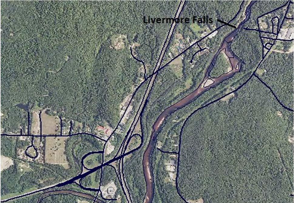
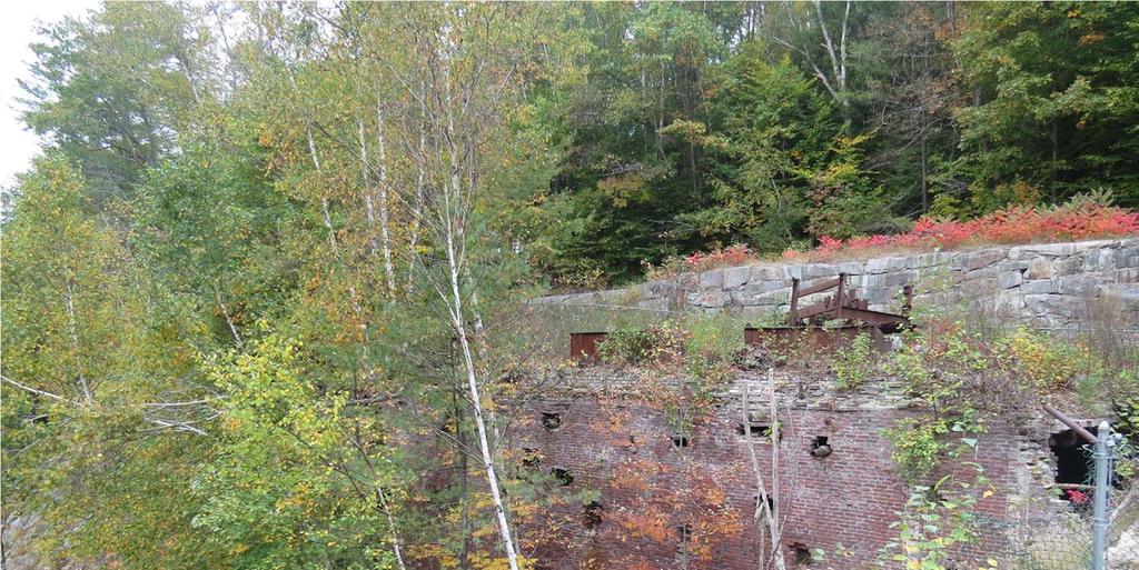
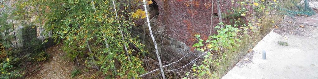
3 A short history of the Livermore Falls area The Holderness side of the river was an active community in the late 19 th century A variety of mills (lumber, grist) The location of the first fish hatchery in the state of New Hampshire (1887) 3

4 Brief History Continued the The Plymouth Campton side was the location of a mill that produced pulp from logs from the White Mountain National Forest. Pulp was then returned to Lincoln to make paper. location of a mill that produced pulp from logs from the White Mountain National Forest. Pulp was then returned to Lincoln to make paper. Plymouth Campton side was the location of a number of mills beginning in the 1880s. Most recent stopped functioning in

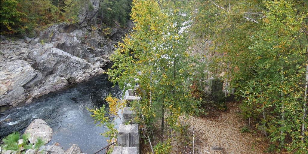
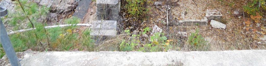
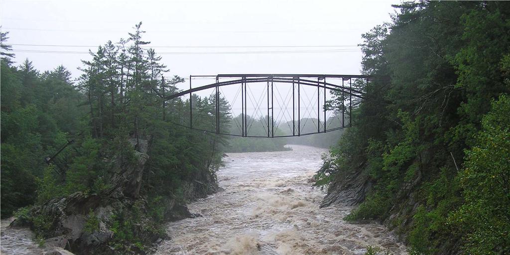
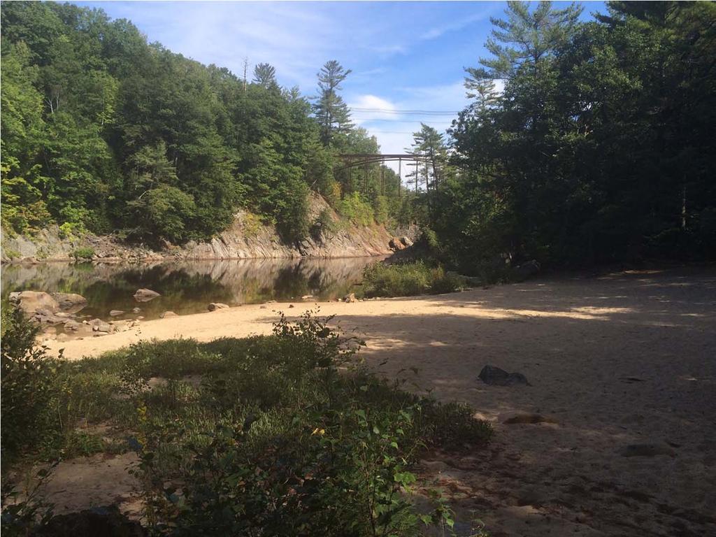
5 Brief History continued Connecting the two sides of the river over time were a series of bridges. The first bridge crossing was constructed in 1869 and the most recent bridge, known by its design as the Pumpkin Seed Bridge, was built in 1886 and closed in The remains of the Pumpkin Seed Bridge are in place on site today. 5
6 6
7 How did ownership change? There were many owners of property on both sides of the river starting in about 1771 (first Charter was in 1751). The bulk of the property surrounding the Falls on both sides of the river, nearly 42 acres, became State property in 1992, utilizing a Land Conservation Improvement Program (LCIP) Grant. No improvements were made on the Plymouth Campton (west) side at this time, but on the Holderness (east) side, the NH Fish and Game Department managed the property as a launching site for boaters. 7
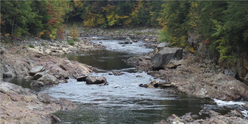
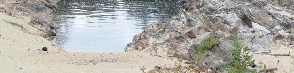
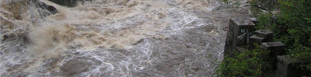
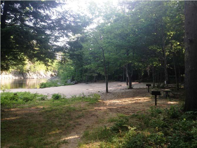
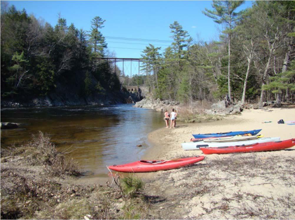
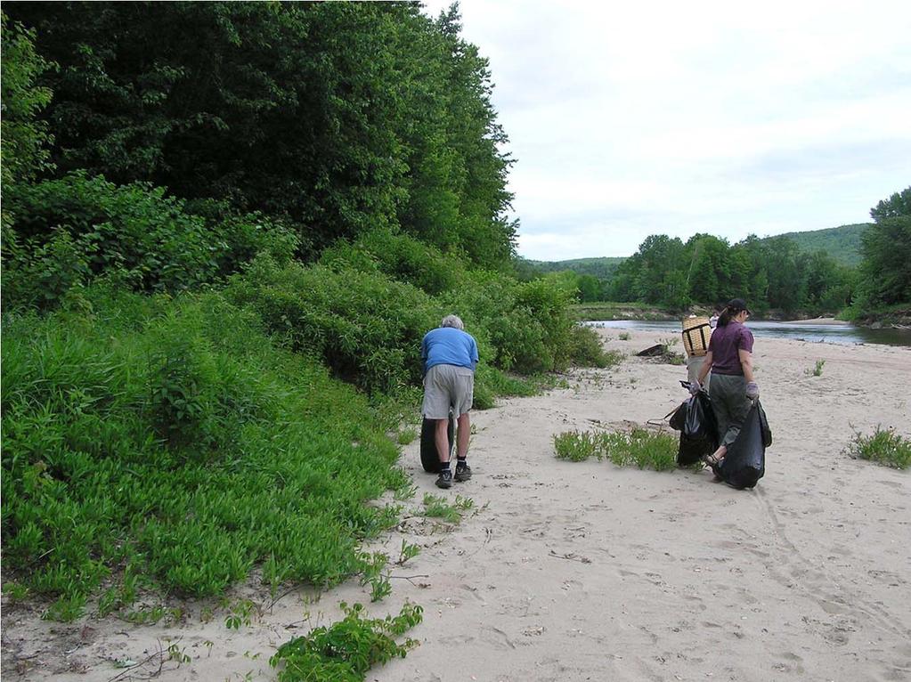
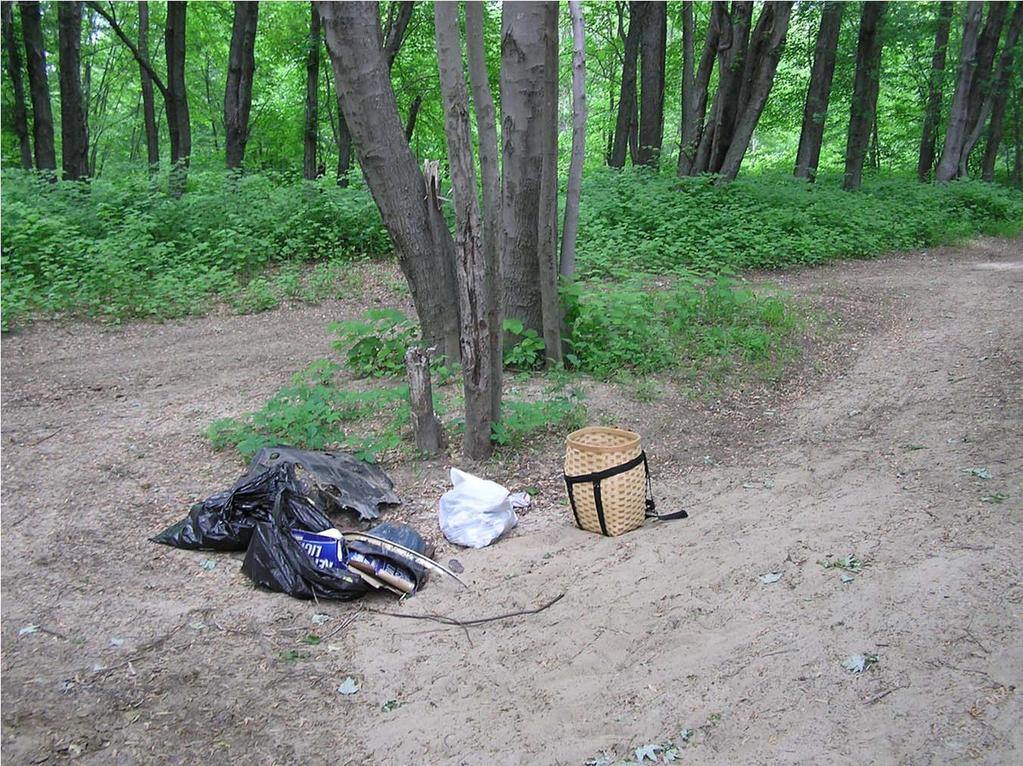
8 The nature of the situation before this program of action Abandoned mill site represented a dangerous situation for visitors Fast flowing river above the falls often caught swimmers and tubers unaware and individuals were swept into the falls. Pumpkin seed bridge represented a diving/jumping challenge to individuals Rope swings on Holderness side represent diving/jumping challenge to individuals Unattended beach on Holderness side became mecca for drinking, fire pits and litter. Beach was unsafe because of broken glass. 8
9 9
10 10
11 11
12 12
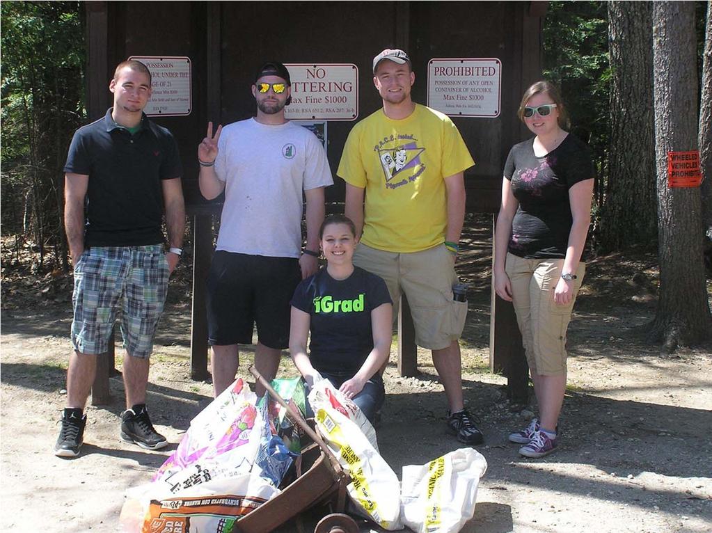
13 NGO 13
14 Friends of the Pemi Timeline Interested organizations and individuals meet 2012 Friends organized with Plymouth Rotary Fall 2013 Community visioning sessions held Winter 2014 DRED assumes responsibility for Livermore Falls Spring 2014 Friends receive grant funding for improvements Summer 2014 Holderness continues supervision of area Summer 2014 Friends organize greeters and events Summer 2015 DRED begins supervision in Holderness Summer
15 Friends of the Pemi Timeline State and Friends agree on needed improvements Fall 2014 Parking lot plans finalized for Holderness Winter 2016 Focus turns to Campton side of river Winter 2016 Planning for summer events in 2016 Now 15
16 Fl Floatfloat The next set of slides would be where you would insert you information about what the state has done, eg., parking lot, volunteers, beach observer, etc. 16
17 17
18 18
19 19
20 20
21 Friends organized a series of informative events, summer of 2015 Spring Cleanup and greeter training Water rescue and safety demo Historical presentation Water Quality Float trip and celebration 21
22 State 22


23 In 1992, the NH Department of Resources and Economic Development (DRED) purchased 41.8 acres of land spanning both sides of the Pemigewasset River around Livermore Falls, joining the larger Livermore Falls State Forest reservation. The New Hampshire Fish and Game Department entered into an agreement with DRED in 2006 to manage the east side of Livermore Falls as a public boat launch. By 2012, with ongoing concerns from the local community about lack of direct staff supervision and management resulting in misuse and vandalism at the property, the NH Fish and Game Department began to transition oversight of the area around Livermore Falls back to DRED and the Division of Parks & Recreation as the agreement between the agencies was also set to expire. With cooperation and help from the newly formed Friends of the Pemi and the Towns of Plymouth, Holderness, and Campton, the Division of Parks began to provide onsite improvements, supervision, and public outreach. 23
 - Developing plans for parking area, access improvement, and interpretive signage (west side) - Decreased litter, drinking, vandalism - Decreased police and rescue")
24 Through the Division s partnership with the Friends of the Pemi, the following has been accomplished since 2013: - Seasonal volunteer clean-up days - Volunteer presence for outreach, visitor research (east side, Friends of the Pemi) - Developing plans for parking area, access improvement, and interpretive signage (west side) - Decreased litter, drinking, vandalism - Decreased police and rescue calls/responses (at one point, Holderness PD reported that 40% of their calls were in response to illegal activities or complaints at Livermore Falls). - More friendly environment for visitation and 18 March use PSU Watershed 24

 - Holderness Police presence for")
25 In 2014, - The Friends of the Pemi coordinated and conducted Visioning Sessions with the citizens of the local communities in March of 2014, collecting people s thoughts, concerns, and ideas for improvement and enhancements. - New Picnic Tables and fire grilles (east side) - Holderness Police presence for outreach and enforcement on site (east side) 25
 - New information kiosk (east side) - Livermore Falls Recreation Area webpage at www.")
26 In 2015, -Regular Park Staff presence for outreach and enforcement on site (east side 2015) -Completion of the first phase of a Cultural Landscape Report and Environmental Assessment. - Finalization of plans for a new parking lot and staffed area (east side, construction set to begin in 2016) - New information kiosk (east side) - Livermore Falls Recreation Area webpage at - Info Table staffed by Volunteers of Friends of Pemi 26
27 27
28 Town 28
29 Areas of interest in Holderness Livermore Beach Flood Plain N South Beach Pemi Riverside Park 29
30 Town Participants The Select Board The Town Administrator The Holderness Police Department The Holderness DPW The Holderness Conservation Commission 30
31 Livermore gorge and beach N.H. Dept. of Resources and Economic Development purchases from Gary Farina 41.8a around Livermore Falls Gorge with Land Conservation Investment Program funds comprising two miles of river frontage and 35.4a in Holderness, 6.4a in Campton & 2.5a between Rte. 3 and the former Boston & Maine (now state-owned) railroad tracks. as per the Aug. 12 Governor & Council approval, all for $393,500 The commission has been cleaning the beach area since the purchase time, usually annually, sometimes more often. The Holderness DPW usually picked up the collected. 31
32 32
33 33
34 34
35 Gorge and Beach cont Although property was owned by DRED, through an agreement, the NH Fish and Game used the site as a put in location for aquatic users (kayaks, canoes, tubes, rafts, etc.) Small parking lot and welcome board was built at the head of the road that leads down to the beach. Five years ago, the Holderness Selectboard recognized a problem with alcohol consumption and unsafe activities and paid for a summer beach attendant out of the Holderness Police Budget for two summers. Selectboard realized problem was not simply a Holderness problem and worked with the late Ray Burton to start a community effort to better manage the gorge and beach sites. 35
36 Moving Down the River Pemi Riverside Park This 2.5 acre parcel was also purchased with LCIP monies. Commission put in two parking places, a trail to the river and took many truck loads of trash out of the park (the area had once been a dumping site for the west side of town). This side also provides access to South Beach and the Flood Plain area. 36
37 37
38 38
39 39

40 40
41 Flood Plain Access to this area is by a road that passes between the Citgo and the Irving Station. Area is used for birding, dog walking, mountain biking and to access South Beach. Because of the delicate nature of the floodplains, the commission has worked closely with Holderness School (the owner or the right ofway and much of the floodplain property) to prohibit motorized access during non snow covered times. 41
42 42
43 43
44 44
45 South Beach This is the name that we ve given to this beach. Access is via the road between the Irving and Citgo stations or by the Pemi Riverside Park property. Commission and mountain bikers usually clean this area at least annually, if not more often. The property is actually in Plymouth. Once drinking was outlawed at the Livermore Gorge beach, usage of the area for recreational drinking and partying has increased. 45
46 46
47 47
48 Long and short term plans Commission has worked closely with Holderness School to restrict use to those that don t damage the floodplain environment. Since the area is also a possible area for future water supply for the towns of Holderness and Plymouth, the Commission would like to see the properties in a conservation easement. The area has also been recognized by the recent NH Wildlife Action Plan as an important ecological area which further substantiates the idea of an easement to protect the environment. 48
49 N G O 49
50 N G O Town 50
51 N G O Town 51
52 N G O Success Town 52


53 Where can I go for more information?? LivermoreFalls.org Friends of the Pemi on Facebook Livermore Falls Recreation Area webpage at

54 Thank you and Questions 54
Rogue River Access and Management Plan Draft Alternatives
 Rogue River Access and Management Plan Draft Alternatives The Rogue River Access and Management Plan was initiated in December, 2011 and is being led by Jackson County Parks (JCP) and Oregon Department
Lincoln Woodstock. Riverfront Park and Trail System. Project Description
 Lincoln Woodstock Riverfront Park and Trail System Project Description Rev: 6 Dated: May 16, 2008 Table of Contents I. Executive Summary Page 3 II. The Riverfront Park Page 4 III. The Trail System Page
2017 Amendment - Public Access and Recreation Management Plan And Road Management Plan CLHCC Review Draft
 Introduction The Connecticut Lakes Headwaters Working Forest Recreation Program, managed by the Division of Parks and Recreation, works closely with local organizations and businesses and the private landowner,
General Rules for Use of Lands Managed by the. Middle Peninsula Chesapeake Bay Public Access Authority
 General Rules for Use of Lands Managed by the Middle Peninsula Chesapeake Bay Public Access Authority As a visitor to lands managed by the Middle Peninsula Chesapeake Bay Public Access Authority (PAA),
DRED ADMINISTRATIVE RULES RES 7300, RES 7400, RES 7800 SUMMARY OF PROPOSED CHANGES
 SUMMARY OF Res 7300 PARKS AND RECREATION 7301 RULES RELATING TO ALL PARKS AND DRED PROPERTIES.02 Definitions R Clarifies DRED personnel definitions k R Updates "service animal" definition.04 2 Violations
Camping (Primitive) Camping (RV) Electrical Potable Water Grill Established Fire Pit Picnic Table
 Camping (RV) Electrical Potable Water Grill Established Fire Pit Picnic Table") Alden - 9th Road River Mile 777 Map: 38.20833, -98.32031 Managing Agency: Kansas Department of Wildlife, Parks & Tourism Nearest Community: Alden, Rice County Kansas Developed Amenities Provided Parking
Alden - 9th Road River Mile 777 Map: 38.20833, -98.32031 Managing Agency: Kansas Department of Wildlife, Parks & Tourism Nearest Community: Alden, Rice County Kansas Developed Amenities Provided Parking
2009 RIVER TOWN OF THE YEAR AWARD APPLICATION Supplemental Material Images
 2009 RIVER TOWN OF THE YEAR AWARD APPLICATION Supplemental Material Images Our History The earliest record of settlement along the river is in 1854; one of the earliest in Carroll County. About this time
THOMAS A. SWIFT METROPARK Introductions History Present Conditions Future Development Plans Implementation Strategies Statistics
 THOMAS A. SWIFT METROPARK Introductions History Present Conditions Future Development Plans Implementation Strategies Statistics Introduction As an open meadow park positioned along the Mahoning River,
ADVENTURE PLAN EXPLORE PARK
 ADVENTURE PLAN ROANOKE COUNTY S EXPLORE PARK ROANOKE COUNTY PARKS, RECREATION AND TOURISM 1206 KESSLER MILL RD SALEM, VA 24153 (540) 387-6078 WHAT S INCLUDED? Explore Park Adventure Plan - Guided by extensive
A CASE FOR COMPLETING THE JORDAN RIVER PARKWAY: A
 A CASE FOR COMPLETING THE JORDAN RIVER PARKWAY: A safe crossing at 9000 South and 850 West Proposed 9000 South Underpass Parkway Timeline Parkway, Trail, and Tourism Facts Blueprint Jordan River 1971 1973
CHAPTER 5. Chapter 5 Recreation Element
 CHAPTER 5 Recreation Element Chapter 5 Recreation Element The Recreation Element of the Meyers Area Plan is a supplement to the Recreation Element of the TRPA Regional Plan and the El Dorado County General
RATTLESNAKE HILL PHILLIPS, HARRIS FARM, LIME KILN & QUARRY
 Town of, MA Trails Map 6a SPLIT ROCK PRIMARY SECONDARY PRIVATE PRIVATE PROPERY STAY ON HEAD FUTURE TO SKINNER (NOT MARKED) 0 miles 0.25 0.250 0.5 Mapbox, Data Odbl, OpenStreetMap contributors primary use
Welcome and thank you for being here! Kick-Off Public Workshop November 19, 2014
 Welcome and thank you for being here! Kick-Off Public Workshop November 19, 2014 OPEN SPACE MATTERS: Boise s First Reserve Master Plan Julia Grant Foothills and Open Space Manager City of Boise Ellen Campfield
Hillsborough County Florida Hillsborough County s Trailways Addressing Program
 Hillsborough County Florida Hillsborough County s 9-1-1 Trailways Addressing Program 2010 ProBike/ProWalk Florida -Conference May 12-13, 2010 1 REQUEST Staff from the Hillsborough County Sheriff s Office
Kansas (KAW) River History
 River History") Kansas (KAW) River History The first map of the Kansas River is dated back to 1718. Lewis and Clark spent 3 days camped at Kaw Point at the confluence of the Kansas and Missouri Rivers. Kansas (KAW) River
Kansas (KAW) River History The first map of the Kansas River is dated back to 1718. Lewis and Clark spent 3 days camped at Kaw Point at the confluence of the Kansas and Missouri Rivers. Kansas (KAW) River
Public Comment. Comment To consider extending State Park lands above River Mile 7.0
 Public To consider extending Park lands above River Mile 7.0 on the Little Spokane River for the conservation and limited recreation qualities they contain is this request. Could this be included in your
New Hampshire Seacoast Greenway
 New Hampshire Seacoast Greenway The NH Seacoast Greenway is New Hampshire s segment of the East Coast Greenway Development of the NHSG has been the subject of a multiyear regional planning effort beginning
TOURISM & PUBLIC SERVICES RURAL SIGNAGE POLICY
 Policy and Procedures Subject Title: Tourism and Public Services Rural Signage Policy Corporate Policy (Approved by Council): X Policy Ref. No.: ROADS-01-07 Administrative Policy (Approved by CAO): By-Law
Bon Portage Island Conservation Campaign
 Bon Portage Island Conservation Campaign Protecting a Coastal Treasure Final Report to Nova Scotia Habitat Conservation Fund September 2012 Protection of Bon Portage Island Over the course of this two-year
Rule Governing the Designation and Establishment of All-Terrain Vehicle Use Trails on State Land
 Rule Governing the Designation and Establishment of All-Terrain Vehicle Use Trails on State Land 1.0 Authority 1.1 This rule is promulgated pursuant to 23 V.S.A. 3506. Section 3506 (b)(4) states that an
Lake Manchester RECREATION GUIDE. seqwater.com.au
 Lake Manchester RECREATION GUIDE seqwater.com.au About Lake Manchester OUR VISION To manage access to recreation opportunities while protecting natural resources and water quality. Lake Manchester is located
Ewen Maddock Dam RECREATION GUIDE
 Ewen Maddock Dam RECREATION GUIDE seqwater.com.au About Ewen Maddock Dam OUR VISION To manage access to recreation opportunities while protecting natural resources and water quality. Ewen Maddock Dam,
CONSERVATION COMMISSION MEETING Thursday, July 19, :00 PM City Hall, Council Chambers, Claremont, NH. MINUTES Approved 8/16/2018
 CONSERVATION COMMISSION MEETING Thursday, July 19, 2018 6:00 PM City Hall, Council Chambers, Claremont, NH MINUTES Approved 8/16/2018 Mr. Dickerman called the meeting to order at 6:03 PM and asked for
Welcome to the future of Terwillegar Park a Unique Natural Park
 Welcome to the future of Terwillegar Park a Unique Natural Park 1 Introduction The Terwillegar Park Concept Plan study will develop an overall concept plan, management objectives and development guidelines
System Group Meeting #1. March 2014
 System Group Meeting #1 March 2014 Meeting #1 Outcomes 1. Understand Your Role 2. List of Revisions to Existing Conditions 3. Information Sources Study Area The Purpose of Mountain Accord is to Preserve
Subj: POLICY FOR MAINSIDE TRAIL USE AT MARINE CORPS BASE QUANTICO
 UNITED STATES MARINE CORPS MARINE CORPS BASE QUANTICO, VIRGINIA 22134-5001 MCBO 5090.4 B 04 MARINE CORPS BASE ORDER 5090.4 From: Commander To: Distribution List Subj: POLICY FOR MAINSIDE TRAIL USE AT MARINE
A Vision for South Skunk River and Chichaqua Bottoms Greenbelt
 A Vision for South Skunk River and Chichaqua Bottoms Greenbelt Photo: Jim Pease Chichaqua Bottoms Booklet 7 of 8 Greater Des Moines Water Trails and Greenways 1 2016 Table of Contents Booklet 1: Water
General Fund. Parks, Recreation, and Community Services. Fiscal Year 2017
 Parks, Recreation, and Community Services Mission: The mission of the City of Rio Rancho s Department of Parks, Recreation, & Community Services is to create and maintain spaces and activities that grow
Chapter 6: POLICY AND PROCEDURE RECOMMENDATIONS
 Chapter 6 POLICY AND PROCEDURE RECOMMENDATIONS FOR SRRA Below are seven policy elements that should be considered for adoption by the Southwest Regional Recreation Authority of Virginia: 1. Develop strategies
Department of Environment, Climate Change & Water NSW. Stakeholder feedback
 Department of Environment, Climate Change & Water NSW Stakeholder feedback 1 Stakeholders group Blue Gum High Forest Group Guardians of Lane Cove NP Sydney Metropolitan Wildlife Service Ku-ring-gai Historical
When One Size Doesn t Fit All Building Volunteers with a Spectrum of Opportunity
 November 2013 PNTS When One Size Doesn t Fit All Building Volunteers with a Spectrum of Opportunity Claire Miller City of Scottsdale McDowell Sonoran Preserve The Preserve is Born 1991 Citizens form the
Preferred Recreation Recommendations Stemilt-Squilchuck Recreation Plan March 2018
 Preferred Recreation Recommendations Stemilt-Squilchuck Recreation Plan March 2018 Below are the recommended recreation ideas and strategies that package together the various recreation concepts compiled
Chapter 2: Summary of Existing Open Space System
 Chapter 2: Summary of Existing Open Space System In 1976, the Wake County Board of Commissioners established the Wake County Parks and Recreation Department in order to provide park facilities and programs
Logo Department Name Agency Organization Organization Address Information 5700 North Sabino Canyon Road
 Logo Department Name Agency Organization Organization Address Information United States Forest Coronado National Forest 5700 North Sabino Canyon Road Department of Service Santa Catalina Ranger District
Environment and Natural Resources Trust Fund 2019 Request for Proposals (RFP)
") Environment and Natural Resources Trust Fund 2019 Request for Proposals (RFP) Project Title: Glacial Edge Trail and Downtown Pedestrian Bridge Category: G. Land Acquisition for Habitat and Recreation ENRTF
Environment and Natural Resources Trust Fund 2019 Request for Proposals (RFP) Project Title: Glacial Edge Trail and Downtown Pedestrian Bridge Category: G. Land Acquisition for Habitat and Recreation ENRTF
SABINE CREEK RANCH RV SITES GUIDE AND RULES
 SABINE CREEK RANCH RV SITES GUIDE AND RULES ABOUT Sabine Creek Ranch is a Christian camp and retreat center offering a beautiful country setting on a 300+ acre working ranch just 30 minutes east of downtown
Procedure for the Use of Power-Driven Mobility Devices on Mass Audubon Sanctuaries 1 September 17, 2012
 Procedure for the Use of Power-Driven Mobility Devices on Mass Audubon Sanctuaries 1 September 17, 2012 Background As part of Mass Audubon s mission to preserve the nature of Massachusetts for people and
Budget Presentation City of Hamilton. January 23, 2018
 Budget Presentation City of Hamilton January 23, 2018 HCA Watershed & 2017 Highlights 2018 Budget Details HCA Land Holdings Acreage - Over 11,000 acres, ~10% of watershed In last decade have significant
BUCKEYE LAKE PROTECTION PLAN THE TOWN OF BEECH MOUNTAIN REGULATIONS GOVERNING IN-LAKE ACTIVITIES AND USES OF BUCKEYE LAKE
 I. PURPOSE BUCKEYE LAKE PROTECTION PLAN THE TOWN OF BEECH MOUNTAIN REGULATIONS GOVERNING IN-LAKE ACTIVITIES AND USES OF BUCKEYE LAKE The purpose of this regulation is to set forth for the Town of Beech
PLANNING COMMISSION AGENDA REPORT May 10, Members of the Planning Commission. Joyce Parker-Bozylinski, Contract Planner
 PLANNING COMMISSION AGENDA REPORT May 10, 2007 TO: FROM: PROPOSAL: APPLICANT: RECOMMENDATION: Members of the Planning Commission Joyce Parker-Bozylinski, Contract Planner Approval of the Calabasas Trails
Park Ranger Program Dallas Park and Recreation Board November 1, 2018
 Park Ranger Program Dallas Park and Recreation Board November 1, 2018 Presentation Overview Purpose/Background/Overview/Hours of Operation Fiscal Year 17/18 Hot Spot/Routine Park Visits Fiscal Year 17/18
Wilds. Headwaters. Lakes. Oxbows. Falls
 56 5 4 3 Wilds Headwaters Lakes Oxbows Falls 57 Zones It could be said the on-the-ground essence of this master plan appears within the next 6 pages of this report. As we learned in the preceding Cultural
Lake Baroon RECREATION GUIDE
 Lake Baroon RECREATION GUIDE seqwater.com.au About Lake Baroon OUR VISION To manage access to recreation opportunities while protecting natural resources and water quality. Lake Baroon, located between
Chapter 9 Recreation
 Chapter 9 Chapter 9 1.0 INTRODUCTION The Town of Littleton is within one of New England s most important recreation areas. More than three million people live within 100 miles of the area. Local residents
O REGON TRAILS SUMMIT. Oregon Trails Summit. Rogue River National Forest
 O REGON TRAILS SUMMIT Oregon Trails Summit 2014 Rogue River National Forest OREGON TRAILS 2015: A VISION FOR THE FUTURE The 2015-2024 Oregon Statewide Trails Plan Why do a trails plan? 2005-2014 Oregon
Hampton Township. Community Description
 Hampton Township Community Description Hampton Township is located in southern Bay County, east of Bay City and Essexville. It contains approximately 9 miles of Saginaw Bay shoreline and 1.5 miles of Saginaw
Stephens Rd. Nature Preserve
 Stephens Rd. Nature Preserve History Stephens Road Nature Preserve (SRNP) is a 350-acre nature preserve in Huntersville that comprises nine properties purchased between 1994 and 2008. Parcels included
City of Haslett. City of East Lansing. City of East Lansing
 Central Park North (Nancy L. Moore Park) Lake Park North Expansion White Park Expansion #2 White Park Expansion #1 County East East Haslett East East TF87-212 Acquisition $90,000.00 Park. TF08-138 Acquisition
Tabor Mountain Recreation Society Who We Are What We Do Regional Park The Ask. Photo by Ken Hodges
 Tabor Mountain Recreation Society Who We Are What We Do Regional Park The Ask Photo by Ken Hodges 1 TMRS History 1961 logging and the Grove Fire activities resulted in many of the existing trails 1961
Final Recreation Report. Sunflower Allotment Grazing Analysis. July 2015
 Final Recreation Report Sunflower Allotment Grazing Analysis July 2015 Table of Contents Introduction... 3 Affected Environment... 3 Four Peaks Wilderness Area... 3 Dispersed Recreation... 3 Environmental
LOCAL PLAN FOR THE MANAGEMENT OF THE APPALACHIAN TRAIL IN MAINE. (GRAFTON NOTCH TO KATAHDIN) 1 January 2013 (Revised 5 February 2014)
 1 January 2013 (Revised 5 February 2014)") LOCAL PLAN FOR THE MANAGEMENT OF THE APPALACHIAN TRAIL IN MAINE (GRAFTON NOTCH TO KATAHDIN) 1 January 2013 (Revised 5 February 2014) The Appalachian Trail is a way, continuous from Katahdin in Maine to
LOCAL PLAN FOR THE MANAGEMENT OF THE APPALACHIAN TRAIL IN MAINE (GRAFTON NOTCH TO KATAHDIN) 1 January 2013 (Revised 5 February 2014) The Appalachian Trail is a way, continuous from Katahdin in Maine to
The Future of the Road to Revolutions. A Battle Road Scenic Byway Public Forum November 9, 2010
 The Future of the Road to Revolutions A Battle Road Scenic Byway Public Forum November 9, 2010 Who is the Battle Road Scenic Byway? Four Towns: Arlington, Lexington, Lincoln, Concord Minute Man National
APPENDIX. I. Meeting Minutes and Presentations
 APPENDIX I. Meeting Minutes and Presentations Public Meeting Agenda 6:00-6:20 Welcome and Refreshments 6:20-6:40 Project Presentation 6:40-7:30 Facilitated Open House www.denvergov.org/parkprojects Please
Conditions of Use & Guest Agreement Package. Mountain Fellowship Camp & Retreat Center
 Conditions of Use & Guest Agreement Package Mountain Fellowship Camp & Retreat Center CONDITIONS OF USE I. Groups using Mountain Fellowship Camp will need to provide the following; A. Linens for a single
Columbia Seaplane Pilots Association
 Columbia Seaplane Pilots Association 13200 Fielding Road President ARON FAEGRE 503-222-2546 Lake Oswego, Oregon 97034 Vice President BILL WAINRIGHT 503-293-7627 website: www.c-spa.org Treasurer CLIFF GERBER
Understanding the caring capacity of the visitor experience Provide facilities to support a high level user experience Address visual quality through
 Understanding the caring capacity of the visitor experience Provide facilities to support a high level user experience Address visual quality through recreation ecological restoration opportunities Collaboration
Explore your Town With The Kingston Area Trail Passport
 Explore your Town With The Kingston Area Trail Passport Don t forget to stop at the children's room in the library for your prize when you collect 5 Passport Stamps! For more natural resource related information,
CITY OF NEW HOPE 4401 XYLON AVENUE NORTH NEW HOPE, MINNESOTA Chair Wills called the meeting to order at 7 p.m.
 CITY OF NEW HOPE 4401 XYLON AVENUE NORTH NEW HOPE, MINNESOTA 55428 Citizen Advisory Commission Regular Meeting CALL TO ORDER Chair Wills called the meeting to order at 7 p.m. December 13, 2016 New Hope
As outlined in the Tatshenshini-Alsek Park Management Agreement, park management will:
 Management Strategy General Strategy The priority management focus for the park is to ensure that its internationally significant natural, cultural heritage and recreational values are protected and that
PROGRESS REPORT WATERFRONT PROGRAM. Q (January - March) Highlights from Q1 2018
 Highlights from Q1 2018") WATERFRONT PROGRAM PROGRESS REPORT Q1 2018 (January - March) Highlights from Q1 2018 Advanced Pier 62 Rebuild construction including completion of Pier 62 demolition in February 2018. Prepared for the
WATERFRONT PROGRAM PROGRESS REPORT Q1 2018 (January - March) Highlights from Q1 2018 Advanced Pier 62 Rebuild construction including completion of Pier 62 demolition in February 2018. Prepared for the
FEASIBILITY STUDY. holdings SEPTEMBER 13, prepared for: prepared by:
 FEASIBILITY STUDY SEPTEMBER 13, 2013 prepared for: holdings prepared by: Table of Contents Project Feasibility... 3 Project Background... 4 Project and Community Context... 5 Site constraints... 6 Statement
Proposal to Redevelop Lower Kananaskis River-Barrier Lake. Bow Valley Provincial Park
 Frequently Asked Questions Proposal to Redevelop Lower Kananaskis River-Barrier Lake Bow Valley Provincial Park Frequently Asked Questions What has been decided? What are the details of the plan? What
Lewis River Recreation Sites
 Lewis River Recreation Sites Parking Fees Hours Visitors entering day-use sites with vehicles must pay applicable fees during peak recreation season. * Pass holders, please check in with booth attendant
Trail # NW Tuesday, June DESIGN. Provide an Review the Provide an. Project Goals: System system. wayfinding
 I. Welcome / Introductions Bethany Creek Trail #2 Segment 3 Neighborhood Meeting #1 Bethany Presbyterian Church 15505 NW Springville Road, Portland, OR 97229 Tuesday, June 26, 2018 @ 6:00PM Meeting Minutes
Flow Stand Up Paddle Board Parkway Plan Analysis
 Regional Parks Department Jeffrey R. Leatherman, Director County of Sacramento Divisions Administration Golf Leisure Services Maintenance Rangers Therapeutic Recreation Services Flow Stand Up Paddle Board
School Group Permits for Kananaskis Country Parks and Protected Areas-Memo
 Parks and Protected Areas School Group Permits for Parks and Protected Areas-Memo From: Date: January 4, 2005 Alberta Parks and Protected Areas Telephone: (403) 678-5508 To: All Alberta School Boards and
Segment 2: La Crescent to Miller s Corner
 goal of the USFWS refuges is to conserve, protect and enhance fish, wildlife and plants and their habitats for the continuing benefit of the American people. Refuge lands are used largely for fishing,
Lake Somerset RECREATION GUIDE
 Lake Somerset RECREATION GUIDE seqwater.com.au OUR VISION To manage access to recreation opportunities while protecting the natural resources and water quality About Lake Somerset Lake Somerset is located
SAXON HARBOR REDEVELOPMENT SURVEY
 SAXON HARBOR REDEVELOPMENT SURVEY SEPTEMBER, 2016 1,173 RESPONSES 1 BACKGROUND 1. WHAT TYPES OF ACTIVITIES DO YOU ENGAGE IN AT SAXON HARBOR Sightseeing Swimming Picnicing Fishing Camping Photography Motorized
I. PREFACE II. THE PARTNERSHIP
 I. PREFACE This document is the "local" plan for the management of the Appalachian Trail in Maine from Maine Highway 26 in Grafton Notch to the summit of Katahdin. It is a part (the other being the Appalachian
LOUISIANA Department of Culture, Recreation, & Tourism
 Management Plan Louisiana LOUISIANA Department of Culture, Recreation, & Tourism National Park Service U. S. Department of the Interior Management Plan Newsletter 2 Public Comment Summary for Dear Friends,
Recreation and Park Commission, Capital Committee
 DATE: March 7, 2018 TO: THRU: FROM: RE: Recreation and Park Commission, Capital Committee Philip A. Ginsburg, General Manager Lisa Bransten, Director of Partnerships New Park at Francisco Reservoir Park
U.S. Army Corps of Engineers Fiscal Year 2013 Handshake Program Application
 U.S. Army Corps of Engineers Fiscal Year 2013 Handshake Program Application Please review instructions before completing application! Corps Lake/Project Name:Rathbun Lake/ North Shore Trail Handshake Proposal
MillenniumPark CHICAGO
 MillenniumPark CHICAGO MILLENNIUM PARK RULES- 2016 UPDATE Welcome to Millennium Park! The "Park" was created for the enjoyment of Chicago residents and visitors. While in the Park, please respect the rights
The Park District will operate the WMRRT using a wide variety
 OPERATIONS & MAINTENANCE PLANS & DETAILS The Park District will operate the WMRRT using a wide variety of professional staff and in accordance with Park District policies, guidelines, and ordinances. This
Santa Clara South Hills Recreation Park Project Development and Management Plan
 Santa Clara South Hills Recreation Park Project Application for Land for Recreation or Public Purposes, City of Santa Clara, Utah Prepared for: Bureau of Land Management, St. George Field Office 345 East
Chapter 6. Action Program. Heart of the Lakes Area Recreation Plan
 Heart of the Lakes Area Recreation Plan 1. Design and construct the following trails (please see the following map): a. the Speedway Trail 1) primary pathway the main trail 2) secondary pathway the proposed
Wallace Falls State Park Classification and Management Planning Stage 3 Preliminary Recommendations July 18, 2018 Sultan City Hall
 Wallace Falls State Park Classification and Management Planning Stage 3 Preliminary Recommendations July 18, 2018 Sultan City Hall Thanks for coming! This document contains State Parks preliminary recommendations
TRUCKEE TAHOE AIRPORT DISTRICT BOARD OF DIRECTOR STAFF REPORT
 AGENDA ITEM: 11 TRUCKEE TAHOE AIRPORT DISTRICT BOARD OF DIRECTOR STAFF REPORT AGENDA TITLE: MEETING DATE: January 24, 2018 PREPARED BY: NTPUD Agency Partnership Opportunity, Multi-Use Trailhead Access
Longmont to Boulder Regional Trail Jay Road Connection DRAFT FINAL REPORT
 Longmont to Boulder Regional Trail Jay Road Connection DRAFT FINAL REPORT December 2018 Project Summary Boulder County, Colorado, in partnership with the City of Boulder, is evaluating options for multi-use
Department of Legislative Services Maryland General Assembly 2009 Session
 Department of Legislative Services Maryland General Assembly 2009 Session SB 650 FISCAL AND POLICY NOTE Senate Bill 650 (Senators Pipkin and Astle) Finance and Budget and Taxation Medevac Helicopter Improvement
Exploring State Water Trail Programs
 National Park Service U.S. Department of the Interior Rivers, Trails, and Conservation Assistance Program Exploring State Water Trail Programs Barbara Nelson- Jameson Corita Waters Jessie Egan E X P E
Willamette River Water Trail Implementation Plan June 2004
 Willamette River Water Trail Implementation Plan June 2004 Prepared by the Willamette Restoration Initiative in cooperation with Summary The Willamette River Water Trail is an opportunity waiting to happen
Lewis River Recreation Sites
 Lewis River Recreation Sites N 0 miles 2 4 8 Parking Fees Hours Visitors entering day-use sites with vehicles must pay applicable fees during peak recreation season. * Pass holders, please check in with
Monterey Bay National Marine Sanctuary Southern Region
 Monterey Bay National Marine Sanctuary Southern Region Connecting Land and Sea - The interface of land and sea is unique, drawing people for its rich bounty, economic opportunity, recreation and inspiration.
Thank you for the opportunity to comment on the proposed action to add trails and trailheads to the Red Rock District trail system.
 July 14, 2010 Jennifer Burns Red Rock Ranger District PO Box 20429 Sedona, AZ 86341 Flagstaff Biking Organization PO Box 23851 Flagstaff, AZ 86002 Dear Jennifer- Thank you for the opportunity to comment
National Recreation Trail Update Form
 National Recreation Trail Update Form Introduction Thank you for taking the time to complete this form. Your assistance will help ensure that the National Recreation Trail (NRT) database is complete and
Business Item No XXX. Proposed Action That the Metropolitan Council approve the Coon Creek Regional Trail Master Plan.
 Business Item No. 2015-XXX Metropolitan Parks and Open Space Commission Meeting date: July 7, 2015 For the Community Development Committee meeting of July 20, 2015 For the Metropolitan Council meeting
SAN ANTONIO RIVER IMPROVEMENTS PROJECT. August 6, 2008
 SAN ANTONIO RIVER IMPROVEMENTS PROJECT August 6, 2008 1 History of the SA River Improvements 1921 Flood Olmos Dam Complete in 1929 Downtown Flood Relief Projects in 1950 s Dams on the River Channel and
Attendance Presentation
 TO The Community of Saanich FROM District of Saanich DATE January 30, 2017 RE Meeting Notes Haro Woods Jan 28th Community Engagement Goward House, 2495 Arbutus Road, Victoria BC Attendance In total, 18
1. Environmental Profile
 1. Environmental Profile The Lakes region is valued above all else as a place of great natural beauty. The abundant mountains, lakes, and pastoral settings provide residents and visitors with incomparable
Stony Creek Master Plan Public Meeting #2. May 21, 2016
 Stony Creek Master Plan Public Meeting #2 May 21, 2016 Today s Agenda 10:00 10:20 am Presentation 10:20 10:45 am Q & A 10:45 11:30 am Browse, discuss, and comment Metroparks Master Plan Process 4 months
MARBLE RIVER PROVINCIAL PARK
 MARBLE RIVER PROVINCIAL PARK PURPOSE STATEMENT AND ZONING PLAN March 2003 MARBLE RIVER PROVINCIAL PARK Purpose Statement and Zoning Plan Primary Role The primary role of Marble River Park is to protect
ORDINANCE NO EXHIBIT A
 ORDINANCE NO. 2017-05 EXHIBIT A City of Lake Dallas, Texas Park Rules and Regulations for Willow Grove Park Preamble: Willow Grove Park ( the Park ) is a public park operated and maintained by the City
Emily to Blind Lake Trail PROPOSED TRAIL DEVELOPMENT APPLICATION SUMMARY
 Emily to Blind Lake Trail PROPOSED TRAIL DEVELOPMENT APPLICATION SUMMARY Township 137 Range 26 (Fairfield Township) sections 2 & 3 Township 138 Range 26 (City of Emily) sections 27, 34, 35, & 36 Township
BRACEVILLE NATURE PRESERVE Introductions History Present Conditions Future Development Plans Implementation Strategies Statistics
 BRACEVILLE NATURE PRESERVE Introductions History Present Conditions Future Development Plans Implementation Strategies Statistics Introduction Braceville Nature Preserve is one of MetroParks largest preserves.
BOAT DOCKS AND LAUNCHES. Public Engagement Report July 2015
 BOAT DOCKS AND LAUNCHES Public Engagement Report July 2015 TABLE OF CONTENTS BACKGROUND 3 STAKEHOLDER CONSULTATION 6 PARTICIPANT PROFILE 7 RESPONSE THEMES 8 CONCLUSION 16 BACKGROUND The North Saskatchewan
Clam Harbour Provincial Park
 Clam Harbour Provincial Park Public Engagement Session Thursday, September 14 th, 2017 5:30pm 7:30pm Webbers Store 11470 Nova Scotia Trunk 7 Lake Charlotte, NS Agenda Overview of the Provincial Parks System
11. Recreational Trails and Pathways Needs
 11. Recreational Trails and Pathways Needs Background Walking, biking, hiking, in-line skating, canoeing, and other trail- and pathway-related activities are important to Boiseans. This importance is demonstrated
State of the City. Mayor Bill Houston City Manager Chris Dick. 1 State of the City Midlothian Chamber of Commerce
 State of the City Mayor Bill Houston City Manager Chris Dick 1 State of the City Midlothian Chamber of Commerce 14 November 2018 Growth & Development Managing Our Finances Quality of Life Public Health