SAN ANTONIO RIVER IMPROVEMENTS PROJECT. August 6, 2008
|
|
|
- Gyles Lane
- 6 years ago
- Views:
Transcription
1 SAN ANTONIO RIVER IMPROVEMENTS PROJECT August 6,
2 History of the SA River Improvements 1921 Flood Olmos Dam Complete in 1929 Downtown Flood Relief Projects in 1950 s Dams on the River Channel and on the two connections to the River Loop the dam at Market in 1950 s and later at Nueva Protects the Riverwalk from flooding Riverwalk sidewalk and bridge improvements s to present Tunnels on SA River and on San Pedro Creek in 1990 s-complete in 1997-$125 M Paid for itself during flood of November,


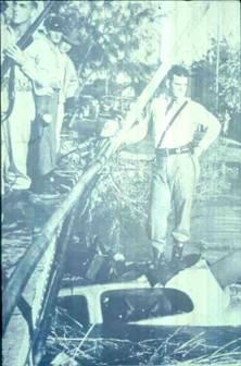
3 San Antonio floods in the 1920 s 3


4 LEGEND SACIP ORIGINAL ALIGNMENT SOUTH OF DOWNTOWN TRIBUTARY HEAD WATERS 4 HILDEBRAND AVE LEXINGTON AVE. ALAZAN NUEVA ST. CREEK CREEK ALAMO ST. SAN ANTONIO RIVER 90 Channelized River CREEK 281 MARTINEZ N W E S DOWNTOWN SAN ANTONIO CREEK APACHE PEDRO SAN MISSION CONCEPCION 81 MISSION SAN JOSE 281 MISSION SAN JUAN 410 ESPADA MISSION

5 Flood Tunnel Boring Machine 5
6 6

7 San Antonio River Tunnel 7

8 Project Limits 8
9 Project Partners City of San Antonio Provides project funding for project amenities (i.e.. Sidewalks, Landscaping, Lighting, etc.) and recreation. San Antonio Water System is providing funding for utility relocation Bexar County Provides project funding for flood control and river restoration elements of the project San Antonio River Authority (SARA) Provides project administration and management U.S. Army Corps of Engineers (USACE) Provides federal funding for river restoration and some recreational components San Antonio River Foundation Provides private funding to support project San Antonio River Oversight Committee A 22 person citizens committee established in 1998 with members appointed by the City, County and SARA representing the various neighborhood and business stakeholders along the river. 9
10 Project Budget Presented in millions of dollars Total City County Private Funds SAWS USACE Concept Design $1.0 $0.3 $ Downtown Reach $13.3 $2.4 $ Eagleland $7.4 $4.3 $ $1.8 Mission Reach $126.6 $15.4 $33.0 $4.8 $1.3 $72.1 Museum Reach $72.1 $52.3 $13.1 $6.5 $0.2 - Visitor Tax $ $ TOTAL $345.4 $74.7 $184.0 $11.3 $1.5 $
11 Project Benefits Ecosystem Restoration The changes proposed will increase water quality and the quantity and diversity of plant and animal species. Flood Damage Reduction Project will maintain or decrease the elevation of the 100 year floodplain. Quality of Life Add to San Antonio s unique charm and make the city more attractive to residents, visitors, and businesses and provide enhanced recreational opportunities along an expanded linear park system. Cultural connections Linking people, neighborhoods and cultural resources and celebrating the historical connection of the river to four of the five historic missions in the San Antonio Missions National Historical Park. Economic Development Promote business development along and adjacent to the river. Improvements will also enhance tourism. 11
12 Museum Reach: Urban Segment Lexington Ave. to Josephine Street 12
13 Project Length Museum Reach Urban Segment Location Map (funding not yet identified) (in final design phase) Z +/- 7,000 LF 13

14 McCullough looking at Lexington 14

15 Brooklyn Lock and Dam 15

16 Lock and Dam at Brooklyn Street Will lift barges approx. nine feet 16

17 Downstream side of Historic Dam 17

18 Jones Ave. looking downstream 18

19 Roy Smith Street looking downstream 19

20 Roy Smith Street Pedestrian Bridge 20

21 Camden Ave. at Grotto Feature 21
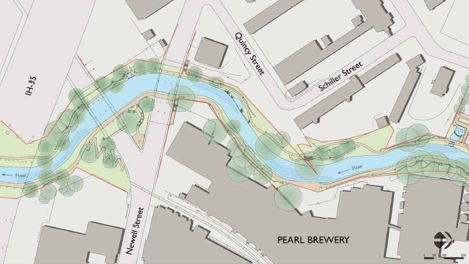
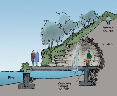
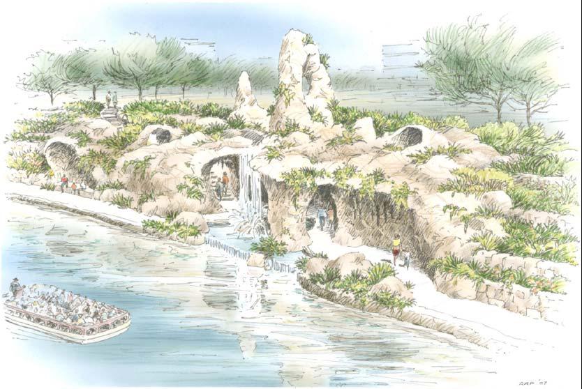
22 Art Enhancement Original Grotto Design Enhanced Grotto Design 22

23 Grayson downstream toward turning basin 23

24 Turning Basin at Grayson Street 24
25 Mission Reach: Project Limits 25


26 Mission Reach Ecosystem Restoration Existing River Channel Proposed River Channel Existing Riverine System Rating = 1.2* Proposed Riverine System Rating = 8.2* * per USACE study; based on scale with 1 as extremely degraded and 10 as pristine; 26 proposed condition rating is at 50 year maturity period


27 27


28 Restoring Habitat Features 24,000 young trees 334 acres of riparian woodland habitat 113 acres of aquatic habitat 31 riffles 13 acres of embayment 2 river remnants: San Juan & Espada 28


29 Ecological & Cultural Connections Mission Concepcion Throughout the 1700 s development of what is now known as the City of San Antonio, occurred when Spanish Colonial missions were established near the natural river banks for the access to water and food. Restoring the river will re-establish the ecological context of the historic Spanish Missions; The project will reconnect the river s significance to the National Park Service s San Antonio Missions National Historical Park. Mission San Jose Mission Espada 29 Mission San Juan

30 Restoration Project Limits: Mission Reach 30

31 Mission Reach Phase I Utility relocation: Completed Contract awarded: May 2008 Project ground breaking: June 2, 2008 Construction completion: Dec Phase I Construction Budget: $23.4 M 31

32 Mission Reach Phase I 32

33 Mission Reach Phase I 33

 Existing")
34 San Antonio River Confluence with San Pedro Creek (end Phase I) Existing Proposed 34


35 Mission Reach Phase II Currently 60% design underway 100% design due: est. March 2009 Bidding start: est. Summer 2009 Construction award: est. Fall 2009 Construction start: est. Winter 2009 Estimated construction budget: $ 34.2 M 35


36 Mission Reach Phase III Currently 60% design underway Construction Award: est. Summer/Fall 2010 Estimated construction budget: $ 13.5 M 36


37 Mission Reach Phase IV Currently 30% design underway Construction Award est.: Summer/Fall 2011 Phase IV construction budget: $ 28,075,000 37
38 Passed on May 10 $125 Million Visitors Tax Mission Reach: $109.5 Million $70 M: Advance funding to keep Phases 2-4 on schedule $39.5 M: Design and construct additional trails, bridge improvements, educational signage, connections to Missions, overlooks, public art and enhanced ecosystem restoration Eagleland Reach: $3 million Design and construct improvements to Alamo Street Bridge, picnic areas, bridge enhancements, overlooks Park Segment: $12.5 million $4.7 M: Fund the design and construction of a basic hike and bike trail and designate a birding area along Avenue $7.8 M: Complete the hike and bike trail components, restore wetlands and acequia at Witte Museum 38
39 For More SARIP Information Information on project status Design details Project history Construction progress photos Web-cam at Lock and Dam 39
SAN ANTONIO RIVER IMPROVEMENTS PROJECT. April 27, 2009
 SAN ANTONIO RIVER IMPROVEMENTS PROJECT April 27, 2009 1 Project Limits 2 Project Partners City of San Antonio Provides project funding for project amenities (i.e.. Sidewalks, Landscaping, Lighting, etc.)
San Antonio Channel Improvement Project MISSION REACH ECOSYSTEM RESTORATION PROJECT. Welcome Assistant Secretary (CW) Jo-Ellen Darcy December 8, 2009
 Jo-Ellen Darcy December 8, 2009") San Antonio Channel Improvement Project MISSION REACH ECOSYSTEM RESTORATION PROJECT Welcome Assistant Secretary (CW) Jo-Ellen Darcy December 8, 2009 1 Presentation Overview Review history of San Antonio
San Antonio Channel Improvement Project MISSION REACH ECOSYSTEM RESTORATION PROJECT Welcome Assistant Secretary (CW) Jo-Ellen Darcy December 8, 2009 1 Presentation Overview Review history of San Antonio
INFILL HARD CORNER & REDEVELOPMENT OPPORTUNITY 731 PROBANDT and 134 & 138 KING ROGER ST
 INFILL HARD CORNER & REDEVELOPMENT OPPORTUNITY 731 PROBANDT and 134 & 138 KING ROGER ST First American Commercial Property Group 18618 Tuscany Stone, Ste. 210, San Antonio, TX 78258 Ph: 210.496.7775 Fx:
TRINITY RIVER CORRIDOR
 TRINITY RIVER CORRIDOR MODIFIED DALLAS FLOODWAY PROJECT UPDATE May 12, 2015 Jon Loxley Project Manager Dallas Floodway Project Fort Worth District U.S. Army Corps of Engineers US Army Corps of Engineers
San Antonio's River Walk Behind the scenes tour or did you know?
 San Antonio's River Walk Behind the scenes tour or did you know? Robert B. Kauffman, Ph.D 7 Hill Top Drive Frostburg, MD 21532 o: (301) 687-4474 e: rkauffman@frostburg.edu All historical slides are from
Sibley LUPA. Board Executive Committee Meeting December 7, 2017
 Sibley LUPA Board Executive Committee Meeting December 7, 2017 Project Location & Project Area 1,318-acre Robert Sibley Volcanic Regional Preserve Project Area Purpose Project Purpose & Goals Append the
Phoenix Habitat Restoration Projects
 Phoenix Habitat Restoration Projects Spur Cross Ranch Cave Creek (Estergard) Regional Tree and Shade Summit March 9, 2010 Desert Riparian Ecosystems Healthy riparian areas like this once existed along
Blue River Trail Master Plan JSA to Town Hall June 2004
 Blue River Trail Master Plan JSA to Town Hall June 2004 Prepared for: Silverthorne Town Council Silverthorne SPORT Committee Department of Recreation and Culture Silverthorne Public Works Silverthorne
WESTSIDE CREEKS ECOSYSTEM RESTORATION. Appendix J: Recreation
 WESTSIDE CREEKS ECOSYSTEM RESTORATION Appendix J: Recreation RECREATION APPENDIX WESTSIDE CREEKS DRAFT RECREATION PLAN Recreation development provides opportunities that significantly benefit communities.
June 13, May 5, September February 23, June 1721
 Tricentennial Milestones Associated with the San Antonio River and its Tributaries. For over 12,000 years, the San Antonio River has supported life and development along its banks. June 13, 1691 Gobernador
Wilds. Headwaters. Lakes. Oxbows. Falls
 56 5 4 3 Wilds Headwaters Lakes Oxbows Falls 57 Zones It could be said the on-the-ground essence of this master plan appears within the next 6 pages of this report. As we learned in the preceding Cultural
Citrus Heights Creek Corridor Trail Project Trail Advisory Group Field Trip #2 September 11, :00 11:00 am Trellis Hall, Citrus Heights
 September 11, 2013 9:00 11:00 am Trellis Hall, Citrus Heights Project Overview The City of Citrus Heights is studying the feasibility of establishing a multi use trail system within the City s 26 miles
The Lower Prut Floodplain Natural Park (Romania)
") The Lower Prut Floodplain Natural Park (Romania) Gabriela Costea Natural Sciences Museum Complex Galati (Romania) & member of the Scientific Council of the Lower Prut Floodplain Natural Park The Prut The
The Lower Prut Floodplain Natural Park (Romania) Gabriela Costea Natural Sciences Museum Complex Galati (Romania) & member of the Scientific Council of the Lower Prut Floodplain Natural Park The Prut The
Environment and Natural Resources Trust Fund 2019 Request for Proposals (RFP)
") Environment and Natural Resources Trust Fund 2019 Request for Proposals (RFP) Project Title: Glacial Edge Trail and Downtown Pedestrian Bridge Category: G. Land Acquisition for Habitat and Recreation ENRTF
Environment and Natural Resources Trust Fund 2019 Request for Proposals (RFP) Project Title: Glacial Edge Trail and Downtown Pedestrian Bridge Category: G. Land Acquisition for Habitat and Recreation ENRTF
April 10, Mark Stiles San Juan Public Lands Center Manager 15 Burnett Court Durango, CO Dear Mark,
 Mark Stiles San Juan Public Lands Center Manager 15 Burnett Court Durango, CO 81301 Dear Mark, We are pleased to offer the following comments on the draft San Juan Public Lands Center management plans
KASKASKIA RIVER NAVIGATION POOL Compartment 12 UNIT 1 Kaskaskia Lock and Dam Lands These lands are now being managed by the Carlyle Lake project
 KASKASKIA RIVER NAVIGATION POOL Compartment 12 UNIT 1 Kaskaskia Lock and Dam Lands These lands are now being managed by the Carlyle Lake project office. Sections 1-4 in this plan present Kaskaskia River
Silver Lake Park An Environmental Jewel for the Citizens of Prince William County
 Silver Lake Park An Environmental Jewel for the Citizens of Prince William County The Prince William Park Authority Mission Statement states: The Prince William County Park Authority will create quality
STORY MILL COMMUNITY PARK
 OWNER: City of Bozeman Department or Parks and Recreation P.O. Box 1230, 415 N. Bozeman Street Bozeman, MT 59715 Tel: (406)-582-2908 APPLICANT: The Trust for Public Land 1007 E. Main Street, Suite 300
Cat Island Chain Background & Access Guide
 Cat Chain Background & Access Guide Brown County Port & Resource Recovery Department 2561 S. Broadway, Green Bay, WI 54304 (920) 492-4950 www.portofgreenbay.com January 2018 1 Restoration of the Cat Chain
Segment 2: La Crescent to Miller s Corner
 goal of the USFWS refuges is to conserve, protect and enhance fish, wildlife and plants and their habitats for the continuing benefit of the American people. Refuge lands are used largely for fishing,
METROPOLITAN COUNCIL 390 North Robert Street, St. Paul, MN Phone (651) TDD (651)
 TDD (651)") DATE: March 27, 2012 METROPOLITAN COUNCIL 390 North Robert Street, St. Paul, MN 55101 Phone (651) 602-1000 TDD (651) 291-0904 TO: Metropolitan Parks and Open Space Commission FROM: Arne Stefferud, Planning
DATE: March 27, 2012 METROPOLITAN COUNCIL 390 North Robert Street, St. Paul, MN 55101 Phone (651) 602-1000 TDD (651) 291-0904 TO: Metropolitan Parks and Open Space Commission FROM: Arne Stefferud, Planning
City Council Workshop July 26, 2010
 Des Moines Trails Connecting a Community City Council Workshop July 26, 2010 1 OVERVIEW Trail Benefits Trails Progress How We Fund Trails What s Next for Trails 2 What is a trail? Paved Trails 10 wide
Trinity River Vision Update
 Trinity River Vision Update Presented to the City Council by: Mark Rauscher, Program Manager Planning & Development Department / Program Management Office August 23, 2011 1 Purpose of the Briefing Overview
Welcome to the Cross County Trail Public Input Session!
 Welcome to the Cross County Trail Public Input Session! Please sign in on the table below! What are we doing here? Camden County has proposed a bicycle and pedestrian trail spanning across the entire county.
crrv OF DALLAS Memorandum Trinity River Corridor Project Update On Recreation
 Memorandum OATE December 8, 2011 crrv OF DALLAS TO Trinity River Corridor Project Committee Members: Vonciel Jones Hill (Chair) Linda Koop (Vice Chair), Monica Alonzo, Scott Griggs, Angela Hunt, Delia
Clackamas County Development Agency
 Clackamas County Development Agency Development Services Building, 150 Beavercreek Rd., Oregon City, OR 97045 www.clackamas.us/transportation/renewal 503-742-4323 The Clackamas County Board of Commissioners
FEASIBILITY CRITERIA
 This chapter describes the methodology and criteria used to evaluate the feasibility of developing trails throughout the study areas. Land availability, habitat sensitivity, roadway crossings and on-street
Preservation & Restoration of the Houston Region s Green Fabric: The Role of the Harris County Flood Control District
 Preservation & Restoration of the Houston Region s Green Fabric: The Role of the Harris County Flood Control District Glenn Laird, Environmental Chief Harris County Flood Control District Parks + Natural
GREATER DES MOINES WATER TRAILS AND GREENWAYS PLAN
 GREATER DES MOINES WATER TRAILS AND GREENWAYS PLAN A shared vision for our rivers, creeks and greenways. www.dmampo.org/water-trails Des Moines Area MPO Iowa Department of Natural Resources dmampo.org/water-trails
Chapter 2: Summary of Existing Open Space System
 Chapter 2: Summary of Existing Open Space System In 1976, the Wake County Board of Commissioners established the Wake County Parks and Recreation Department in order to provide park facilities and programs
Comprehensive Bibliography of Archaeological Projects The Mission San Josẻ y San Miguel de Aguayo (41BX3) Collections
 Collections") Comprehensive Bibliography of Archaeological Projects The Mission San Josẻ y San Miguel de Aguayo (41BX3) Collections Bradford, J., and D. Traylor 1981 Archaeological Excavations at the Mission San José
Comprehensive Bibliography of Archaeological Projects The Mission San Josẻ y San Miguel de Aguayo (41BX3) Collections Bradford, J., and D. Traylor 1981 Archaeological Excavations at the Mission San José
2009 RIVER TOWN OF THE YEAR AWARD APPLICATION Supplemental Material Images
 2009 RIVER TOWN OF THE YEAR AWARD APPLICATION Supplemental Material Images Our History The earliest record of settlement along the river is in 1854; one of the earliest in Carroll County. About this time
COASTAL CONSERVANCY. Staff Recommendation December 2, 2004 COYOTE HELLYER COUNTY PARK BAY AREA RIDGE TRAIL
 COASTAL CONSERVANCY Staff Recommendation December 2, 2004 COYOTE HELLYER COUNTY PARK BAY AREA RIDGE TRAIL File No. 04-057 Project Manager: Amy Hutzel RECOMMENDED ACTION: Authorization to disburse up to
TRUCKEE TAHOE AIRPORT DISTRICT BOARD OF DIRECTOR STAFF REPORT
 AGENDA ITEM: 11 TRUCKEE TAHOE AIRPORT DISTRICT BOARD OF DIRECTOR STAFF REPORT AGENDA TITLE: MEETING DATE: January 24, 2018 PREPARED BY: NTPUD Agency Partnership Opportunity, Multi-Use Trailhead Access
A CASE FOR COMPLETING THE JORDAN RIVER PARKWAY: A
 A CASE FOR COMPLETING THE JORDAN RIVER PARKWAY: A safe crossing at 9000 South and 850 West Proposed 9000 South Underpass Parkway Timeline Parkway, Trail, and Tourism Facts Blueprint Jordan River 1971 1973
City of Haslett. City of East Lansing. City of East Lansing
 Central Park North (Nancy L. Moore Park) Lake Park North Expansion White Park Expansion #2 White Park Expansion #1 County East East Haslett East East TF87-212 Acquisition $90,000.00 Park. TF08-138 Acquisition
Clam Harbour Provincial Park
 Clam Harbour Provincial Park Public Engagement Session Thursday, September 14 th, 2017 5:30pm 7:30pm Webbers Store 11470 Nova Scotia Trunk 7 Lake Charlotte, NS Agenda Overview of the Provincial Parks System
Committee. Presentation Outline
 CW-33-15 11/9/2015 Community and Corporate Services Committee November 10, 2015 1 Presentation Outline Background Vision and Objectives Study Process and Timeline Public and Stakeholder Engagement Organization
Parks & Recreation Areas Program
 PARKS & RECREATION Parks & Recreation Areas Program As part of its mission to conserve and protect natural resources, the Upper Big Blue Natural Resources District (NRD) has been involved in several large-scale
Dungeness Recreation Area County Park Master Plan
 Dungeness Recreation Area County Park Public Outreach Meeting October 10, 2007 Project Overview USFWS Site Dungeness Recreation Area County Park Meeting Objectives: Re-Introduce project; provide status
Everett Riverwalk Life style explore
 Life style explore Project Overview The 217-acre Everett Riverfront redevelopment is visible from I-5 with traffic counts charted at 170,000+ vehicles per day with direct freeway access from 4-way interchange.
Westside Creeks Restoration Oversight Committee (WCROC) Meeting San Antonio River Authority 100 E. Guenther Tuesday, October 18, 2016 Notes
 Meeting San Antonio River Authority 100 E. Guenther Tuesday, October 18, 2016 Notes") Westside Creeks Restoration Oversight Committee (WCROC) Meeting San Antonio River Authority 100 E. Guenther Tuesday, October 18, 2016 Notes Committee Members Present: Robert Ramirez, Co-Chair Olga Lizcano,
Westside Creeks Restoration Oversight Committee (WCROC) Meeting San Antonio River Authority 100 E. Guenther Tuesday, October 18, 2016 Notes Committee Members Present: Robert Ramirez, Co-Chair Olga Lizcano,
An experimental habitat enhancement effort for a sandy river: San Rafael River restoration project
 An experimental habitat enhancement effort for a sandy river: San Rafael River restoration project Samuel Lyster Department of Watershed Sciences, Utah State University Brian G. Laub Department of Watershed
RIVER ACCESS STRATEGY
 RIVER ACCESS STRATEGY The River Access Strategy is a 10-year plan the City of Edmonton is developing to inform future programming, operations and infrastructure improvements that support access to the
B10. Agate Beach State Recreation Site
 B10. Agate Beach State Recreation Site Location Within the City of Newport, just south of the Yaquina Head Outstanding Natural Area. The park is located along the west side of Highway 101 at the mouth
March 2, The Honorable Mayor Williams D. Sessoms, Jr. Members of City Council. Subject: Coastal CIP Presentation to City Council - March 6, 2018
 OFFICE OF THE CITY MANAGER (757) 385-4242 (757) 427-5626 FAX MUNICIPAL CENTER BUILDING 1, ROOM 234 2401 COURTHOUSE DRIVE VIRGINIA BEACH, VA 23456-9001 March 2, 2018 The Honorable Mayor Williams D. Sessoms,
CITY OF SAN ANTONIO RIVER BARGE DESIGN COMPETITION UPDATED 11/19/2015
 CITY OF SAN ANTONIO RIVER BARGE DESIGN COMPETITION UPDATED 11/19/2015 BACKGROUND The City of San Antonio is the seventh largest city in the United States. A large city with a small town feel, San Antonio
Final Drainage Letter Pikes Peak Community College Downtown Parking Lot Colorado Springs, Colorado
 Final Drainage Letter Pikes Peak Community College Downtown Parking Lot Colorado Springs, Colorado Prepared for: Pikes Peak Community College 5775 South Academy Boulevard Colorado Springs, CO 80906-5422
Fort Myers Downtown & Riverfront Redevelopment
 Fort Myers Downtown & Riverfront Redevelopment Brought to you by the Fort Myers Community Redevelopment Agency (CRA) Fort Myers Community Redevelopment Agency The Fort Myers Community Redevelopment Agency
The Vision for the San Juan Islands Scenic Byway
 The Vision for the San Juan Islands Scenic Byway 2 Judd Cove, Orcas Island, Courtesy of Kurt Thorson (kurtthorson.com) and San Juan County Land Bank Vision for the San Juan Islands Scenic Byway The San
PROFESSIONALLY LEASED & MANAGED BY PROMINENTLY LOCATED IN NORTH CENTRAL SAN ANTONIO, ADJACENT TO SA INT L AIRPORT.
 PROFESSIONALLY LEASED & MANAGED BY PROMINENTLY LOCATED IN NORTH CENTRAL SAN ANTONIO, ADJACENT TO SA INT L AIRPORT FROM 1,155 TO 23,318 RSF AVAILABLE FOR LEASE ONE INTERNATIONAL CENTRE is a fifteen-story,
how it started where we are now what is coming up NEW WESTMINSTER WATERFRONT PARK THE RIVER THE PAST THE PEOPLE
 how it started Downtown Waterfront Park How It Started March 2009 City of New Westminster Purchases 3.2 Hectare Westminster Pier Site March 2009 City of New Westminster and Design Team develop plan for
NAVAJO COMMUNITY PLAN
 NAVAJO COMMUNITY PLAN Prepared by the NAVAJO COMMUNITY PLANNERS and THE CITY OF SAN DIEGO City of San Diego Planning Department 202 C Street, MS 4A San Diego, CA 92101 Printed on recycled paper. This information,
Buffalo District Navigation Program Overview
 Buffalo District Navigation Program Overview 16 FEB 2011 US Army Corps of Engineers Buffalo District Area of Operations Our Facilities District Headquarters 2 Area Offices 3 Regulatory Field Offices Lake
ARCHAEOLOGICAL MONITORING OF THE ASHBY STREET DRAINAGE PROJECT, SAN ANTONIO, BEXAR COUNTY, TEXAS
 ARCHAEOLOGICAL MONITORING OF THE ASHBY STREET DRAINAGE PROJECT, SAN ANTONIO, BEXAR COUNTY, TEXAS Anne A. Fox and I. Waynne Cox / Center for Archaeological Research The University of Texas at San Antonio
Acquisition in fee simple of approximately one-half acre of property on the shore of Spring Lake to expand the Lakeside Beach Park.
 Lakeside Beach TF00-136 $122,550.00 in fee simple of approximately one-half acre of property on the shore of Spring Lake to exp the Lakeside Beach. 2000 River Ravines TF00-150 $910,000.00 in fee simple
A Vision for South Skunk River and Chichaqua Bottoms Greenbelt
 A Vision for South Skunk River and Chichaqua Bottoms Greenbelt Photo: Jim Pease Chichaqua Bottoms Booklet 7 of 8 Greater Des Moines Water Trails and Greenways 1 2016 Table of Contents Booklet 1: Water
user s guide to Transportation Improvements in Astoria Planning Efforts outside Astoria for more information, contact:
 The Miles Crossing/ Jeffers Garden transportation plan (underway), will identify needed improvements to the Warrenton Astoria Highway and local street improvements to serve expected growth in the Miles
Section II. Planning & Public Process Planning for the Baker/Carver Regional Trail began in 2010 as a City of Minnetrista initiative.
 Section II Planning & Public Process Planning for the began in 2010 as a City of initiative. city staff began discussions with the Park District on the possibility of a north/south regional trail connection
Understanding the caring capacity of the visitor experience Provide facilities to support a high level user experience Address visual quality through
 Understanding the caring capacity of the visitor experience Provide facilities to support a high level user experience Address visual quality through recreation ecological restoration opportunities Collaboration
OR MISSION TRAIL ELEMENTARY
 Leawood: overview OVERLAD PARK 24: p.70 I-LA PARK 32: p.72 TOMAHAWK PARK 23: p.69 31: p.71 GEZER PARK OR MISSIO TRAIL ELEMETARY 22: p.68 W 133rd St W 135th St KASAS CITY MO - other segments Beginning/end
River Parks Trail: Tulsa, Oklahoma
 River Parks Trail: Tulsa, Oklahoma Purpose: The purpose of the River Parks Trail is to maintain, preserve, develop, and promote the Arkansas River for the economic and cultural benefit of the community.
PARK BRAD KAUFMAN LARRY MENDEZ
 TRAVIS TRAVIS LEASING INFORMATION BRAD KAUFMAN 210.253.2922 LARRY MENDEZ 210.253.2924 brad.kaufman@transwestern.com larry.mendez@transwestern.com N Saint Marys St TRAVIS BRAD KAUFMAN 210.253.2922 brad.kaufman@transwestern.com
Centred Outdoors is an open invitation for people of all ages and fitness levels to explore ten outdoor destinations in Centre County, Pennsylvania,
 Centred Outdoors is an open invitation for people of all ages and fitness levels to explore ten outdoor destinations in Centre County, Pennsylvania, throughout the summer of 2018. Together, we ll stress
Preferred Recreation Recommendations Stemilt-Squilchuck Recreation Plan March 2018
 Preferred Recreation Recommendations Stemilt-Squilchuck Recreation Plan March 2018 Below are the recommended recreation ideas and strategies that package together the various recreation concepts compiled
China Creek North Park Upgrades and Glen Pump Station. Park Board Committee Meeting Monday, July 10, 2017
 China Creek North Park Upgrades and Glen Pump Station Park Board Committee Meeting Monday, July 10, 2017 Purpose The purpose of this presentation is to: Share the results of the public engagement processes;
Markham Multi-use Pathway (MUP) (16 th Avenue to Bob Hunter Memorial Park) Development Services Committee. January 27, Schollen & Company Inc.
 (16 th Avenue to Bob Hunter Memorial Park) Development Services Committee. January 27, Schollen & Company Inc.") Markham Multi-use Pathway (MUP) (16 th Avenue to Bob Hunter Memorial Park) January 27, 2015 Development Services Committee Mark Schollen Schollen & Company Inc. Purpose of Presentation Update Council on
Markham Multi-use Pathway (MUP) (16 th Avenue to Bob Hunter Memorial Park) January 27, 2015 Development Services Committee Mark Schollen Schollen & Company Inc. Purpose of Presentation Update Council on
CHURCH AVENUE CHULA VISTA, CA 91910
 For Additional Information: Sean Bascom 619.916.9179 bascom@scc1031.com Lic# 01862044 CHURCH AVENUE CHULA VISTA, CA 91910 CHULA VISTA DEVELOPMENT OPPORTUNITY Excellent Location Near Vibrant Third Avenue
Bear Creek Habitat Improvement Project
 06/10/10 Bear Creek Habitat Improvement Project El Paso County, Colorado Pike National Forest and Colorado Springs Utilities Owned Land Report prepared by: Eric Billmeyer Executive Director Rocky Mountain
Mississippi River Parkway Commission of Minnesota
 Mississippi River Parkway Commission of Minnesota Bluffs Region (Hastings to Iowa Border) September 23, 2016 10:00 11:30 a.m. Red Wing Ignite 419 Bush Street, Red Wing, MN Bluffs Region Agenda I. Welcome
HARP AUTHORITY GATEWAY CENTER BOATHOUSE & CHANNEL EXTENSION TO SANTA FE AVENUE. Pueblo City Council Presentation September 17, 2018
 HARP AUTHORITY GATEWAY CENTER BOATHOUSE & CHANNEL EXTENSION TO SANTA FE AVENUE Pueblo City Council Presentation September 17, 2018 PROJECT: 1A HARP Expansion FUNDING 1A Ballot Issue Pueblo County : $3,000,000
Appendix 3. Greenway Design Standards. The Whitemarsh Township Greenway Plan
 Appendix 3 Greenway Design Standards This chapter discusses two design standards for the greenway types discussed above. First, trail design standards are presented together with trailhead facilities and
Northeast Quadrant Distinctive Features
 NORTHEAST QUADRANT Northeast Quadrant Distinctive Features LAND USE The Northeast Quadrant includes all the area within the planning area that is east of Interstate 5 and to the north of State Route 44.
Hawke s Bay Regional Parks Network. Pekapeka Regional Park Individual Park Plan
 Hawke s Bay Regional Parks Network Pekapeka Regional Park Individual Park Plan 2015-2024 Hawke s Bay Regional Council 159 Dalton Street Private Bag 6006 Napier 4110 Hawke s Bay New Zealand Telephone: 0800
4.0 Context for the Crossing Project
 4.0 Context for the Crossing Project This section provides background information about key features of the North Douglas Crossing project area, and opportunities and constraints. This information is important
Southwest Quadrant Distinctive Features
 SOUTHWEST QUADRANT Southwest Quadrant Distinctive Features LAND USE The 31.17 square mile Southwest Quadrant includes all the area within the planning area west of I-5 and south of the Sacramento River.
City of Durango 5.8 FUNDING TRAILS DEVELOPMENT
 5.8 FUNDING TRAILS DEVELOPMENT The City has been successful in establishing dedicated local funding sources as well as applying for grants to develop the City s trail system, having received nearly $2.4
Southport Setback Levee Recreation Trail Report. West Sacramento, CA September 12, 2017
 Southport Setback Levee Recreation Trail Report West Sacramento, CA September 12, 2017 Contents Acronyms and Abbreviations... iii 1 Introduction... 1 1.1 Project Setting... 1 1.2 Project Description and
Update on Trinity Trails. Presented by: Richard Zavala, Director Park and Recreation Department February 7, 2017
 Update on Trinity Trails Presented by: Richard Zavala, Director Park and Recreation Department February 7, 2017 Overview Provide review of trail planning and development along the main stem Trinity River
Stage 2 ION: Light Rail Transit (LRT) from Kitchener to Cambridge
 from Kitchener to Cambridge") Stage 2 ION: Light Rail Transit (LRT) from Kitchener to Cambridge Public Consultation Centre (PCC) No. 3 Please Sign-in Cambridge City Hall November 21, 2017 2:00 to 8:00pm Preston Memorial Auditorium
Stage 2 ION: Light Rail Transit (LRT) from Kitchener to Cambridge Public Consultation Centre (PCC) No. 3 Please Sign-in Cambridge City Hall November 21, 2017 2:00 to 8:00pm Preston Memorial Auditorium
1 PROJECT STATUS UPDATE 2 ND CONCESSION FROM BRISTOL ROAD TO DOANE ROAD TOWNS OF EAST GWILLIMBURY AND NEWMARKET
 Report No. 3 of the Regional Council Meeting of March 28, 2013 1 PROJECT STATUS UPDATE 2 ND CONCESSION FROM BRISTOL ROAD TO DOANE ROAD TOWNS OF EAST GWILLIMBURY AND NEWMARKET The recommends: 1. Receipt
Citrus Heights Creek Corridor Trail Project. Trail Advisory Group Meeting #3 July 8, 2013
 Citrus Heights Creek Corridor Trail Project Trail Advisory Group Meeting #3 July 8, 2013 Agenda Introductions Recap: Community Workshop, Survey Findings, and TAG Field Trip Community Concern Discussion:
LAND USE GUIDELINES NEW TOWN
 VI LAND USE A L T ETruRck TNraiAl T I V E S AarNnelDla D E S I G N W GUIDELINES NEW TOWN ad Ro DAVEN CA LF IRE ALTERNATIVE LAND USE PLANS AND DESIGN GUIDELINES - VI VI LAND USE ALTERNATIVES Asilomar Hotel
Hemisfair Civic Park. Vision and Program Plan
 Hemisfair Civic Park Vision and Program Plan OCTOBER 2013 Hemisfair Civic Park Vision and Program Plan Prepared under the direction of the Hemisfair Park Area Redevelopment Corporation. Planning assistance
ROAD AND TRAIL PROJECT APPROVAL
 ROAD AND TRAIL PROJECT APPROVAL www.marincountyparks.org Marin County Parks, 3501 Civic Center Dr, Suite 260, San Rafael, CA 94903 DATE: July 12, 2017 PRESERVE: Gary Giacomini Open Space Preserve PROJECT:
Presented to: City of Petaluma City Council
 Agenda Item #1.A REVISED Presented to: City of Petaluma City Council Presented By: Dan St. John, F.ASCE, Director Jason Beatty, P.E., Senior Engineer James 'Jody' Boyette, USACE Project Manager November
Trail Feasibility Study
 VOLUSIA COUNTY MPO CITY OF NEW SMYRNA BEACH FINAL REPORT JUNE 30, 2009 Trail Feasibility Study What s inside? 1 Introduction 2 Project Purpose & Scope 3 Physical Inventory & Assessment of Right-of- Way
SECTION 3 GENERAL DESCRIPTION OF THE RIVER BASIN
 SECTION 3 GENERAL DESCRIPTION OF THE RIVER BASIN SECTION 3 GENERAL DESCRIPTION OF THE RIVER BASIN River basin description. A general description of the river basin or subbasin, as appropriate, in which
BASSETTS CREEK SECTION CONTENTS: BASSETTS CREEK BRYN MAWR LUCE LINE
 BASSETTS CREEK SECTION CONTENTS: BASSETTS CREEK BRYN MAWR LUCE LINE GLENWOOD AVE MULTI-USE DIAMONDS VINCENT AVE N MORGAN AVE N PENN AVE N DOG PARK MULTI-USE FIELDS PLAYGROUND AK E RD S CHESTNUT AVE DA
AGENCY NAME TRANSPORTATION
 TRANSPORTATION TRANSPORTATION AGENCY NAME Prince William County FY 2015 BUDGET CIP-TRANSPORTATION 561 Fuller Road/Fuller Heights Road Improvements Total Project Cost - $4.4 M This project will widen Fuller
Historic Highway Advisory Committee To Meet in The Dalles
 In This Issue Get Involved Highway Gets Major Endorsement New Life for the Old Road Bike Pods and Hubs Time Travel on the Historic Highway Gorge Ride 2014 The Historic Columbia River Highway News is your
Framework Agreement on the Sava River Basin and its implementation
 Framework Agreement on the Sava River Basin and its implementation Dejan Komatina, Ph.D. Civ. Eng., Secretary, ISRBC Samo Grošelj, Deputy Secretary Overview Introduction on the Sava river basin Establishment
CHULA VISTA DEVELOPMENT OPPORTUNITY. For Additional Information: Sean Bascom Lic#
 For Additional Information: Sean Bascom 619.916.9179 bascom@scc1031.com Lic# 01862044 CHULA VISTA DEVELOPMENT OPPORTUNITY Excellent Location Near Vibrant Third Avenue Village High Density Zoning Building
Yarmouth Technical Assistance Panel Oct 17, Yarmouth TAP
 Yarmouth Technical Assistance Panel Oct 17, 2017 Yarmouth TAP October 17, 2017 Westfield Technical Yarmouth Assistance Technical Assistance Panel, October Panel 26, 17, 2015 2017 About ULI the Urban Land
NFTA Access Enhancement Study for Canalside and Cobblestone Alternatives Discussion. Alternative A South Park Avenue
 Alternative A South Park Avenue Alternative A Summary Alternative A extends Metro Rail service around the foot of Main Street east along South Park Avenue to serve a new station platform located along
COMMUNITY MEETING NOVEMBER 1, Wheaton Regional Park Pine Lake Trail
 COMMUNITY MEETING NOVEMBER 1, 2012 MEETING AGENDA I. Introduction of Project Team II. Trail Renovation Process III. Wheaton Regional Park IV. Pine Lake Trail Renovation Project V. Comments and Questions
230 CHURCH AVENUE CHULA VISTA, CA 91910
 Excellent Location Near Vibrant Third Avenue Village High Density Zoning Building Height up to 45 Lot size of 11,326 sqft Flat/Graded Lot Ease of Access to Utility Hookups Multiple Allowed Uses For Additional
Classifications, Inventory and Level of Service
 Classifications, Inventory and Level of Service Section 3 Kenmore Park, Recreation and Open Space Plan 1 P a g e Classifications and Inventory Park Classifications Kenmore classifies its parks based upon
ONONDAGA CREEKWALK PHASE II. Public Information Meeting Series 1
 ONONDAGA CREEKWALK PHASE II Public Information Meeting Series 1 Andrew Maxwell Director, Syracuse-Onondaga County Planning Agency Owen Kerney Assistant Director for City Planning Russell Houck, PE City
Section 3.6 Recreation
 3.6 RECREATION This section evaluates the potential impacts of the proposed project on recreation within MTRP. The evaluation is based on field observations, a review of maps of MTRP and the MTRP Master