Chapter 9 Recreation
|
|
|
- Deirdre McKinney
- 5 years ago
- Views:
Transcription
1 Chapter 9

2 Chapter INTRODUCTION The Town of Littleton is within one of New England s most important recreation areas. More than three million people live within 100 miles of the area. Local residents and tourists from the northeastern United States and Quebec fish, boat, swim, picnic, hunt, snowmobile, and ski in or around the Littleton area. Grafton County provides 38% of the recreational land in New Hampshire, and more people are now participating in a wider range of recreational activities than ever before. This rich natural and cultural landscape provides a wonderful setting, and the four-season climate allows for a diversity of recreational activities. Promoting and encouraging the enjoyment of Littleton s landscape enhances the quality of life of local residents and supports tourism in the region. This promotion provides an opportunity for personal health and wellness benefits, economic opportunities, and portrays Littleton as a prime location in the White Mountains of New Hampshire for recreation and access to the great outdoors. With increased use of these resources Littleton must also be mindful of the resource management issues that can arise from increased use of the recreational areas in the community. According to the 2003 Master Plan Survey Littleton residents value the outdoor recreation opportunities available to them (39%), and would like to see more facilities in Littleton. 2.0 COMMUNITY RECREATION VALUES AND GOALS The results from the Littleton Master Plan Survey show strong appreciation and support for recreation. The responses show that 58% of the respondents felt that proximity to the White Mountains made Littleton a desirable place to live/visit, and 57% would like to see more preservation of open space in Littleton over the next ten years. When asked about pursuing the development of additional recreational facilities in Littleton 40% of the survey respondents wanted cross country trails, 62% wanted more bicycle and pedestrian trails, and 69% would like walking paths. Overall there was great support for additional paths for a multitude of uses, depending on the season, and for additional preserved open space. This is good news for recreation, Littleton Master Plan ~
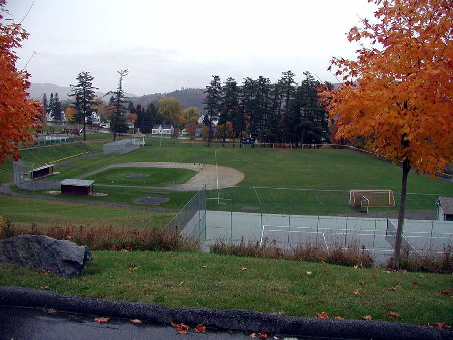
3 transportation, natural resources, and general land use issues. Pursuing the protection of a network of open spaces in Littleton, and creating a network of trails and paths could provide additional recreational opportunities and connections, help protect key natural resource corridors, provide additional transportation options, promote health and wellness, and provide spaces between places in Littleton. 3.0 EXISTING RESOURCES 3.1 Town Facilities The Littleton Parks and Department maintains the following facilities which are open to the public: Remich Park provides recreational fields for the high school and a public recreation area. This fifteen acre park includes recreational fields, tennis courts, locker rooms, two baseball fields, a soccer field, a playground, a recreation room, a public swimming pool, as well as a cross country skiing area, ice-skating rink, and sledding hill in the winter. Littleton High School also uses these facilities for its sports programs. Apthorp Commons is a five acre public recreational facility in Littleton. This park has a softball field, soccer field, a playground, basketball court, two tennis courts, and an area for fishing on the Ammonoosuc River. The Norton Pike Fields encompass approximately three acres including a softball field and youth soccer field. The Brickyard Road recreation area has a full size soccer field. 3.2 Trails in Littleton The Littleton Conservation Commission (LCC) published a map in the spring of 2000 describing town hiking trails in Littleton. Table 9-A identifies these trails and their locations are outlined in Figure 9-B. The trails include the walking trail at the Dells, Kilburn Crags, and the Pine Hill Trails which are maintained by the Littleton Parks and Department. Littleton Master Plan ~
4 Table 9-A Hiking Trails in Littleton Name Littleton Hospital Walking and Interpretive Trail Kilburn Crags The Dells Pine Hill Trails Description Used by patients, employees, and the general public for fitness and relaxation. Educates trail walkers about their natural surroundings. Located off of Route 135. Short 7/10-mile hike offers rich geologic history and views to the Presidential Range. Short walking trail around the edge of Dell s Pond Public trail system within easy walking distance to the downtown. The main trail is a one-mile loop The Dells In 1917, Daniel Remich gave an area known as The Dells to the Town of Littleton to be kept as a park forever. The Dells is open year round for snowmobiling, x-country skiing, picnicking, walking, and fishing is allowed. This area is owned by the Town, managed by the Conservation Commission, and is open to the public. There are many birds that use this area for habitat, and along the walking trails there are many varieties of wildflowers as well. The main walking trail within the park connects Dells Road to NH Route 18. Parking areas are available at each end of the trail Pine Hill Trails The Pine Hill Trails begin at the Remich Park trailhead and create a one mile round trip woods walk. The trail system passes a number of glacial erratics, and there are a wide variety of northern birds and plant species. The trail system connects to other trails in the area leading to the old Town Ski Jump site, the Town Reservoir, and Palmer Brook Kilburn Crags Located between NH Route 18/135 and U.S. Route 302 the Kilburn Crags offer a glimpse at Littleton s rich geologic history. Another legacy to the Town by Daniel Remich, the trailhead and parking area are located on NH Route 18/135. The 7/10 of a mile hiking trail leads through a meadow and then through the woods to a spectacular view of Littleton, the Ammonoosuc River Valley, and the Presidential Range Snowmobile Trails Another popular recreational activity in Littleton is snowmobiling. The State maintains a series of trails but there are also local trails. These trails are primarily on abandoned roads, logging roads, etc. The Snowmobile Club publishes a map of trails located in Littleton, which has been transferred onto Figure 9-B. Littleton Master Plan ~

5 Figure 9-B Trails Source: Littleton Natural Resource Inventory Class VI Roads Class VI roads are those that the Town owns but does not maintain for vehicular travel. Although not used for automobiles, Class VI roads have other contributions as routes for hiking and biking, horseback riding, cross country skiing, and hunting. There are two Class VI roads in Littleton, as shown in Table 9-C. Table 9-C Class VI Roads Name From Mileage Mt. Misery Road North Littleton Road Foster Hill Road Maintained Section Source: Littleton Town Office, 2002 Littleton Master Plan ~
6 3.4 Public es There are currently 780 water bodies considered Great Ponds in the State of New Hampshire and four of them are in Littleton. Table 9-D summarizes these water bodies and the status of public access on each water body. Table 9-D Great Ponds and Public Access Name Size (acres) Public Access Moore Reservoir 3500 Yes Comerford Reservoir 1093 Yes Partridge Lake 105 Yes Reynolds Pond 19 None Source: NRI, Lobdell Associates, 2002 There are four boat launches on Moore Reservoir in Littleton and one at Comerford below Moore dam. Additionally, there are canoe take outs and portages around both dams. According to RSA 271:20-A, bodies of water greater than ten acres in size are public waters. RSA 233-A states that the State of New Hampshire must provide one public access site for water bodies acres in size, two access sites for lakes acres in size, etc. A public access site is defined as those launch sites that are owned and or controlled by the State of New Hampshire. New Hampshire Fish and Game (NHF&G) manages the lake access program. There are, however, several other access sites around the lakes that are open to the public. 3.5 Moore and Comerford Reservoir and the Fifteen-Mile Falls Project The largest single recreational area in Littleton is the Fifteen-Mile Falls hydroelectric project owned by the U.S. Generating Company. The project area includes about a 26- mile stretch of the Connecticut River, of which 16 miles is in Littleton. The resources include the Moore Reservoir (3531 acres), the Comerford Reservoir (1093 acres) and the McIndoe Reservoir (570 acres). Also, approximately 6,000 acres of forestland around the reservoirs (primarily Moore) will soon be protected by conservation easements for recreational and forest management. There are several recreational activities currently available including boating, sailing, canoeing, fishing, swimming, hiking, snowmobiling, and bird watching. al facilities include twelve recreation access areas, including a visitor center at Moore dam, boat launches, picnic areas, hiking trails, swimming areas and parking. Figure 9-E shows the Fifteen-Mile Falls recreation resources and they are listed in Table 9-F. Of the twelve facilities six are located in the Town of Littleton and five on Moore Reservoir. Littleton Master Plan ~
7 As part of the recent Fifteen Mile Falls re-licensing, a recreation study was conducted to determine user characteristics at the twelve recreation sites. Highlights of the study include: Annually 138,000 visitors utilize the sites. Of those, 67% visited sites in Littleton, with the Dodge Hill and Moore Visitor Center receiving the most visitors. Picnicking was the most popular activity followed by sightseeing, boat fishing, swimming and motor boating. Other activities included mountain biking, tubing, walking and relaxing. The visitor s area was used primarily by locals. Approximately 55% of the visitors were from New Hampshire, 37% from Vermont, and 3% from Massachusetts. During the non-peak period (November-April), ice fishing was the most popular activity, but many people reported bank fishing, snowmobiling, and hunting during this time period. Visitors spend an average of $33.02 per visit or $1.4 million annually. Combined with estimated secondary economic impacts, recreational users of the project areas accounted for $1.8 million in The reservoirs are also used for Fishing tournaments and events. One major tournament was held in 2003 along with several smaller events. A survey of fifteen Mile Falls users was completed to assess public opinion and the following was found: 77% felt the use of the areas had not significantly increased in the past few years 87% felt the existing recreation facilities are adequate to meet the needs. On a scale of 1 to 5 for crowdedness (with 5 being very crowded), visitors rated the area as a 1.54, or not very crowded. Future improvement to the recreation areas are planned, but no major changes. For the Littleton sites, improvements include improving boat ramps, creation of additional parking, creation of additional swimming areas, additional picnic tables, etc. A total of about $130,000 of improvements have been planned, and work on these improvements should begin in Littleton Master Plan ~
8 Figure 9-E 15 Mile Falls Area Littleton Master Plan ~
9 Table 9-F 15 Mile Falls Areas Facility Moore Reservoir Gilman North Littleton Dodge Hill Pattenville Pine Island Moore Dam Visitor Center Fishing Swimming Nature Trail Picnic Area ADA Facilities Picnic Tables Port-a-Johns 10 Parking Spaces Grills/ Fireplaces Jun Portage Trail Waterford Comerford Reservoir Waterford Bridge Pine Grove Comerford Dam Picnic Area May Littleton Master Plan ~
10 3.7 Local Facility Level of Use According to the Littleton Parks and Department, the recreational facilities in Littleton are experiencing a steady increase in use. In some cases groups are being turned away when trying to reserve facilities that are already booked up. The Parks and Department reports that there are currently twelve programs, beyond the school sports programs, that are using the existing facilities throughout the year. These include the following identified programs in Table 9-G. Table 9-G Programs in Littleton Activity Grades/ Age Range Time of Year Enrollment Biddy Basketball Grades K-6 Winter 60 Park Program Grades K-6 Summer 120 Swim Lessons Grades K-8 Summer 120 Youth Soccer Grades K-6 Fall 138 T-ball Grades K-2 Spring 50 Pony League Grades 2-3 Spring 60 Carl Ripken Baseball Grades 4-6 Spring 75 Girls Softball Grades 4-6 Spring 36 Babe Ruth Baseball Grades 8-12 Summer 40 Girl s Softball Ages Summer 15 Littleton Youth Hockey Ages Year-round Men s Summer Soccer Ages 18 and over Summer 25 Men s Senior Softball League Summer 3.8 Regional Resources Within an hour drive of Littleton, there are numerous State of New Hampshire and State of Vermont parks, forests, fish and wildlife management areas, local parks, as well as the 773,241 acre White Mountain National Forest. These regional resources provide numerous and varied public recreation opportunities. Within a one hour drive, there are nine New Hampshire State Parks and eight Vermont State Parks offering camping facilities, hiking trails, snow skiing, and public access to lakes for fishing, boating, swimming and many other recreation opportunities. There are also eight wildlife management areas and numerous fish and wildlife areas where hunting and fishing are allowed. Towns and organizations also own and operate public parks and forest reserves in the region offering both active and passive pursuits, free and for-a-fee, with some handicapped accessible facilities. 4.0 RECREATION TRENDS IN NEW HAMPSHIRE In 2003 the State of NH completed a State Comprehensive Outdoor Plan (SCORP). The SCORP explains that more people are participating in recreational Littleton Master Plan ~
11 activities, partially due to the increase in population, and that people are also participating in a much wider range of activities today than was even the case ten years ago. With this in mind it is easy to imagine that the most popular sites will experience greater and greater congestion in the future. This could result in a greater number of conflicts between recreationists vying for use of the same areas at the same times. Access to all recreation sites will become an important management issue. Meanwhile, the number of organized recreation and conservation groups is expected to continue to grow and will have an increasingly larger voice in the management of public land. According to the State, New Hampshire State Parks have seen an increase in attendance. Current estimates indicate State Parks saw around 6.69 million visitors in According to the Comprehensive Statewide Trails Study, conducted by the New Hampshire Office of State Planning in 1997, the US Forest Service reports a 23-percent increase in trail use in the WMNF between 1974 and The State also reports that wheeled off-highway vehicle registrations, both in-state and out-of-state, are increasing. Total registrations have more than doubled in the last seven years. Out-of-state registrations have more than tripled. Out-of-state snowmobile registrations are steadily increasing. Out-of-state registrations have more than doubled in the last seven years, while in-state registrations have remained steady. New Hampshire s waters have also experienced an increase in use with boating registrations doubling between 1980 and 1990, and increasing over 19 percent between 1990 and With this increased interest in recreation, and its corresponding pressure on recreational areas, it is important to remember that the majority of recreational land acreage is found in the northern part of New Hampshire. According to the findings in the SCORP, many of the most popular activities in New Hampshire are similar to those identified in nationwide studies. Wildlife observation, driving for pleasure, sightseeing, and jogging/running/walking are extremely popular activities. Additionally, these activities show a high frequency of participation. Day hiking seems to be more popular in New Hampshire than the national average. The most popular activities in the WMNF include viewing wildlife and natural features, sightseeing, hiking and walking, general relaxation, driving for pleasure on forest roads, cross-country skiing, and developed camping. 5.0 LAND USE IMPLICATIONS AND POTENTIAL ACTIONS Land Use Implications Littleton s existing recreation resources provide area residents and visitors with exceptional opportunities to enjoy outdoors and exercise. Here are a few items to consider related to the recreation resources in Littleton. Littleton Master Plan ~
12 1) Having an interconnected system of trails within a greenway of protected land provides recreation, health and wellness, natural resource, transportation, and economic benefits that help shape the character of Littleton. 2) The Conservation Commission has voiced concerns related to the trails in Littleton that include: Trail Erosion; Vandalism and Trash; Lack of Maintenance, particularly of trails around Moore Reservoir; Loss of trails on town land due to changes in land use. 3) Overall there is a need to incorporate outdoor recreation more fully as an issue within larger discussions of land use and transportation in Littleton because of the many benefits this amenity provides. Potential Actions There are an array of possible actions the Town may want to consider pursuing as it evaluates and improves the existing recreation resources in Littleton. This section will be used to identify the specific actions for Littleton to take upon completion of the master plan. 1) Consider creating a non-motorized trail network/greenway plan for the entire town that identifies future trail connections and properties to be protected. This could include a path to the Brickyard Road field, and a multi-use trail from the downtown out to the hospital site. 2) Some of the new trails the Conservation Commission would like to see established include additional trails around Moore Reservoir and completion of the riverwalk/railbed trail. 3) The community should address the long-term stewardship issues of the protected parcels and recreational facilities in Littleton. This may include roles for the various user groups and clubs (i.e. horseback riders, snowmobilers, mountain bikers, Littleton Off- Road Riders, etc.) in monitoring properties and trail maintenance. 4) Educate landowners about the benefits of leaving lands open to the public and the liability protections provided by existing laws. 5) Promote the use of education and information-based strategies to manage or avoid conflicts between user groups. 6) Ensure that recreational opportunities are available to those with disabilities. Littleton Master Plan ~
2. Goals and Policies. The following are the adopted Parks and Trails Goals for Stillwater Township:
 D. PARKS AND TRAILS 1. Introduction Stillwater Township s population is relatively low, with most residents living on rural residences on large lots. The need for active park space has been minimal in
CHAPTER 5. Chapter 5 Recreation Element
 CHAPTER 5 Recreation Element Chapter 5 Recreation Element The Recreation Element of the Meyers Area Plan is a supplement to the Recreation Element of the TRPA Regional Plan and the El Dorado County General
Chapter eight. Parks and Recreation. Introduction. Crystal Lake Park District
 Chapter eight Parks and Recreation Introduction One of the indicators of quality of life in a city is the parks and recreation system. The City of Crystal Lake is fortunate to have an excellent parks and
Public Park System. Township of Derry. Providing natural open space for the recreational use of our residents and guests.
 Township of Derry Public Park System Providing natural open space for the recreational use of our residents and guests. Directory of Recreational Amenities Hershey s Commitment to Recreation Famous candy
J. Recreation Plan of Conservation and Development. The Town of Hebron. Section 2. Preservation of Unique Assets. 1 P a g e
 The Town of Hebron Section 2 2014 Plan of Conservation and Development Preservation of Unique Assets J. Recreation Open spaces, parks, sports fields, and recreational programs are considered essential
AMERICAN S PARTICIPATION IN OUTDOOR RECREATION: Results From NSRE 2000 (With weighted data) (Round 1)
 (Round 1)") AMERICAN S PARTICIPATION IN OUTDOOR RECREATION: Results From NSRE 2000 (With weighted data) (Round 1) The emphasis of this report is on participation patterns across activities and segments of our society.
AMERICAN S PARTICIPATION IN OUTDOOR RECREATION: Results From NSRE 2000 (With weighted data) (Round 1) The emphasis of this report is on participation patterns across activities and segments of our society.
10/25/2013. What is the SCORP?! 2013 Local Government Survey 2013 Statewide Public Survey Advisory Group Priority Areas Your Suggestions!
 COLORADO OUTDOOR RECREATION TRENDS RESULTS FROM THE SCORP AND STATEWIDE Colorado Outdoor Recreation Resource Partnership September 2013 PRESENTATION What is the SCORP?! 2013 Local Government Survey 2013
4.19 Parks, Recreation, and Conservation Lands
 interchange would have on the Reed Paige Clark Homestead located on the north side of Stonehenge Road. Alternative D would also affect Palmer Homestead, E.F. Adams House, and Knapp Brothers Shoe Manufacturing
System Group Meeting #1. March 2014
 System Group Meeting #1 March 2014 Meeting #1 Outcomes 1. Understand Your Role 2. List of Revisions to Existing Conditions 3. Information Sources Study Area The Purpose of Mountain Accord is to Preserve
The City of Durango Community Interest and Opinion Survey Executive Summary
 The City of Durango Community Interest and Opinion Survey Executive Summary Overview ETC Institute administered a community interest and opinion survey for the City of Durango between January and March
Blueways: Rivers, lakes, or streams with public access for recreation that includes fishing, nature observation, and opportunities for boating.
 Parks, Open Space and Trails PRINCE WILLIAM COUNTY 2008 COMPREHENSIVE PLAN TRAILS PLAN CONTENTS The components of the trails plan are: Intent Definitions Goals, Policies, and Action Strategies Trails Map
CHAPTER ONE LITERATURE REVIEW
 CHAPTER ONE LITERATURE REVIEW LITERATURE REVIEW This chapter summarizes the most recently published community impact studies and articles that relate to multiuse trails. The review focuses on publications
Lake Myra County Park. Wake County, North Carolina Community Forum #2 June 12, 2008
 Lake Myra County Park Wake County, North Carolina Community Forum #2 June 12, 2008 Welcome and Introduction Meeting Agenda Welcome Introductions of Project Team Master Plan Process Community Forum #1 Updates
State Park Visitor Survey
 State Park Visitor Survey Methods, Findings and Conclusions State s Department of Recreation, Park and Tourism Management surveyed state park visitor and trip characteristics, and collected evaluations
Acquisition in fee simple of approximately one-half acre of property on the shore of Spring Lake to expand the Lakeside Beach Park.
 Lakeside Beach TF00-136 $122,550.00 in fee simple of approximately one-half acre of property on the shore of Spring Lake to exp the Lakeside Beach. 2000 River Ravines TF00-150 $910,000.00 in fee simple
Park Design and Location Criteria
 Park Design and Location Criteria This section is presented in the interest of assisting park and recreation agencies in the development of a system of parks and recreation areas. A recreation system is
National Recreation Trail Update Form
 National Recreation Trail Update Form Introduction Thank you for taking the time to complete this form. Your assistance will help ensure that the National Recreation Trail (NRT) database is complete and
National Recreation Trail Application for Designation
 National Recreation Trail Application for Designation Introduction Thank you for your interest in the National Recreation Trail (NRT) program. Completed NRT application packages must be submitted by December
Trails. Lois Jensen Nature Preserve is a 30 acre parcel on the north end of the city. It provides unspoiled wooded paths.
 Trails Lois Jensen Nature Preserve is a 30 acre parcel on the north end of the city. It provides unspoiled wooded paths. TRAIL S, PATHS, ROUTES AND CONNECTORS Citizen input pointed to trails, paths, bike
City of Somersworth. Recreation Division
 City of Somersworth Recreation Division 2018 Park Inventory Table of Contents I. Ash Street Park..1-3 II. Jules Bisson Park..6-10 III. Malley Farm Recreational Area.11-12 IV. Mast Point Dam Recreation
Living & Working Access and Recreation
 Living & Working Access and Recreation 5.9 Access and Recreation Background 5.9.1 The countryside has increasingly become a popular destination for visitors and an important resource for informal recreation.
The Recreational Trail along Cushing Park road has been a successful addition to the city
 The Recreational Trail along Cushing Park road has been a successful addition to the city Trails TRAILS, PATHS, ROUTES AND CONNECTORS Citizen input pointed to trails, paths, bike routes, and other non-motorized
City of Keller Parks and Facilities Inventory
 City of Keller Parks and Facilities Inventory April 2013 1. BEAR CREEK PARK 44 ACRES 1 Basketball Court with 2 goals 4 Drinking Fountains 1 Large Pavilion with 4 picnic tables, electricity and fireplace
Appendix A BC Provincial Parks System Goals
 Appendix A BC Provincial Parks System Goals The British Columbia Provincial Parks System has two mandates: To conserve significant and representative natural and cultural resources To provide a wide variety
Chapter 6. Action Program. Heart of the Lakes Area Recreation Plan
 Heart of the Lakes Area Recreation Plan 1. Design and construct the following trails (please see the following map): a. the Speedway Trail 1) primary pathway the main trail 2) secondary pathway the proposed
Understanding the caring capacity of the visitor experience Provide facilities to support a high level user experience Address visual quality through
 Understanding the caring capacity of the visitor experience Provide facilities to support a high level user experience Address visual quality through recreation ecological restoration opportunities Collaboration
WASHINGTON STATE PARKS LAND CLASSIFICATION SYSTEM
 WASHINGTON STATE PARKS LAND CLASSIFICATION SYSTEM Administrative Code Establishing Land Classification System WAC 352-16-020 Land classification system. State park areas are of statewide natural, cultural,
Ardmore Parks and Recreation. Spring/Summer 2014 E X P L O R E ARDMORE. K i d s
 Ardmore Parks and Recreation www.funinardmore.org www.ardmorecity.org Spring/Summer 2014 S p e c i a l E v e n t s E X P L O R E ARDMORE K i d s A c t i v e A d u l t s A t h l e t i c s D r a m a Administration
PIONEER PARK. City of Des Peres Parks Master Plan. SWT Design 46 INTRODUCTION
 PIONEER PARK INTRODUCTION Pioneer Park is a 7 acre neighborhood park located east of Interstate 270 and south of Manchester Road along Tallie Road. The park is situated in a residential neighborhood with
13.1 REGIONAL TOURISM ISSUES AND SUMMARY OF FINDINGS
 13 REGIONAL TOURISM T he County of Mariposa s recreation needs and facilities fall within two categories: regional tourism and local recreation. This Element focuses on regional tourism issues related
Preferred Recreation Recommendations Stemilt-Squilchuck Recreation Plan March 2018
 Preferred Recreation Recommendations Stemilt-Squilchuck Recreation Plan March 2018 Below are the recommended recreation ideas and strategies that package together the various recreation concepts compiled
MOREAU LAKE STATE PARK CURRENT PLANNING EFFORTS
 MOREAU LAKE STATE PARK CURRENT PLANNING EFFORTS PLANNING EFFORTS S O U T H E R N PA L M E R T O W N CONSERVATION & ECONOMIC DEVELOPMENT STRATEGY Moreau Lake State Park Master Plan Mt. McGregor Correctional
COLORADO STATE PARKS NORTHWEST REGION RON VELARDE NORTHWEST REGIONAL MANAGER
 COLORADO STATE PARKS NORTHWEST REGION RON VELARDE NORTHWEST REGIONAL MANAGER COLORADO STATE PARKS NORTHWEST REGION HIGHLINE LAKE JAMES M. ROBB COLORADO RIVER VEGA RIFLE COMPLEX SYLVAN LAKE STAGECOACH STATE
Flow Stand Up Paddle Board Parkway Plan Analysis
 Regional Parks Department Jeffrey R. Leatherman, Director County of Sacramento Divisions Administration Golf Leisure Services Maintenance Rangers Therapeutic Recreation Services Flow Stand Up Paddle Board
Lincoln County ORP Survey Response Summary
 Lincoln County ORP Survey Response Summary North Central Wisconsin Regional Planning Commission Q1 Which recreational activities did you participate in during 2015? (Choose all that apply.) Answered: 125
Parks, Recreation, Trails and Open Space Master Plan Survey Results. October 2018
 Parks, Recreation, Trails and Open Space Master Plan Survey Results October 2018 Conducted by Qualtrics subconsultant 300 completed responses Random attempt to get a balanced response from all four Council
Classifications, Inventory and Level of Service
 Classifications, Inventory and Level of Service Section 3 Kenmore Park, Recreation and Open Space Plan 1 P a g e Classifications and Inventory Park Classifications Kenmore classifies its parks based upon
Parks & Recreation Areas Program
 PARKS & RECREATION Parks & Recreation Areas Program As part of its mission to conserve and protect natural resources, the Upper Big Blue Natural Resources District (NRD) has been involved in several large-scale
Rogue River Access and Management Plan Draft Alternatives
 Rogue River Access and Management Plan Draft Alternatives The Rogue River Access and Management Plan was initiated in December, 2011 and is being led by Jackson County Parks (JCP) and Oregon Department
Schoolcraft Township is located in northeast Houghton County. A portion of the township borders Keweenaw County and Lake Superior.
 COMMUNITY DESCRIPTION Schoolcraft Township is located in northeast Houghton County. A portion of the township borders Keweenaw County and Lake Superior. The township is largely rural but has one main population
Appendix D ( Rock Climbing Survey) Scroll Down
 Scroll Down") Appendix D (E-mail Rock Climbing Survey) Scroll Down 51 2006 Coopers Rock Recreation Study West Virginia University Dear Recreationist: The Department of Recreation, Parks, and Tourism Resources at West
Appendix D (E-mail Rock Climbing Survey) Scroll Down 51 2006 Coopers Rock Recreation Study West Virginia University Dear Recreationist: The Department of Recreation, Parks, and Tourism Resources at West
MASTER PLAN EXECUTIVE SUMMARY
 Biscuit Run State Park Scottsville Road (State Route 20) Charlottesville, VA 22902 Biscuit Run State Park MASTER PLAN EXECUTIVE SUMMARY Department of Conservation and Recreation Division of Planning and
City of Durango 5.8 FUNDING TRAILS DEVELOPMENT
 5.8 FUNDING TRAILS DEVELOPMENT The City has been successful in establishing dedicated local funding sources as well as applying for grants to develop the City s trail system, having received nearly $2.4
Port Gamble Shoreline Area Conceptual Trail Proposal
 The North Kitsap Trails Association is pleased to be a partner to the Kitsap Forest and Bay Project and assist Kitsap County, Forterra, Olympic Property Group, Great Peninsula Conservancy and the Port
BASSETTS CREEK SECTION CONTENTS: BASSETTS CREEK BRYN MAWR LUCE LINE
 BASSETTS CREEK SECTION CONTENTS: BASSETTS CREEK BRYN MAWR LUCE LINE GLENWOOD AVE MULTI-USE DIAMONDS VINCENT AVE N MORGAN AVE N PENN AVE N DOG PARK MULTI-USE FIELDS PLAYGROUND AK E RD S CHESTNUT AVE DA
Crystal Lake Area Trails
 Lake Area Trails Welcome to the Lake area of the Big Snowy Mountains! This island mountain range in central Montana features peaks reaching to 8,600 feet and long, high ridges from which vistas of the
Southwest Quadrant Distinctive Features
 SOUTHWEST QUADRANT Southwest Quadrant Distinctive Features LAND USE The 31.17 square mile Southwest Quadrant includes all the area within the planning area west of I-5 and south of the Sacramento River.
Table of Contents. page 3 Long term Goals Project Scope Project History. 4 User Groups Defined Trail Representative Committee. 5 Trail Users Breakdown
 Launched April 27th, 2010 1 Table of Contents page 3 Long term Goals Project Scope Project History 4 User Groups Defined Trail Representative Committee 5 Trail Users Breakdown 13 Trail Users Desires 16
F. Forest Recreation Management
 F. Forest Recreation Management F.1) Park and Recreation Management F.1.A. Program Overview. The park and recreation program has been in existence since 1980. With ever increasing outdoor recreation demands
Susitna-Watana Hydroelectric Project (FERC No ) Recreation Resources Study Study Plan Section Study Implementation Report
 Recreation Resources Study Study Plan Section Study Implementation Report") (FERC No. 14241) Recreation Resources Study Study Plan Section 12.5 2014 Study Implementation Report Prepared for Prepared by AECOM November 2015 TABLE OF CONTENTS 1. Introduction... 4 2. Study Objectives...
(FERC No. 14241) Recreation Resources Study Study Plan Section 12.5 2014 Study Implementation Report Prepared for Prepared by AECOM November 2015 TABLE OF CONTENTS 1. Introduction... 4 2. Study Objectives...
Chambers of Commerce and Lake Groups advertised this NCWRPC created online survey that was : Opened: August 22, 2012; and Closed: October 4, 2012.
 Vilas County Outdoor Recreation Survey Chambers of Commerce and Lake Groups advertised this NCWRPC created online survey that was : Opened: August 22, 202; and Closed: October 4, 202. Q What Vilas County
1. Environmental Profile
 1. Environmental Profile The Lakes region is valued above all else as a place of great natural beauty. The abundant mountains, lakes, and pastoral settings provide residents and visitors with incomparable
Chapter 6: POLICY AND PROCEDURE RECOMMENDATIONS
 Chapter 6 POLICY AND PROCEDURE RECOMMENDATIONS FOR SRRA Below are seven policy elements that should be considered for adoption by the Southwest Regional Recreation Authority of Virginia: 1. Develop strategies
Northeast Quadrant Distinctive Features
 NORTHEAST QUADRANT Northeast Quadrant Distinctive Features LAND USE The Northeast Quadrant includes all the area within the planning area that is east of Interstate 5 and to the north of State Route 44.
PROPOSED PARK ALTERNATIVES
 8 Chimne y Rock State Park M a ster Pl an 2011 PROPOSED PARK ALTERNATIVES Introduction Three different park development concepts were prepared and presented to the citizens of North Carolina through a
Wilds. Headwaters. Lakes. Oxbows. Falls
 56 5 4 3 Wilds Headwaters Lakes Oxbows Falls 57 Zones It could be said the on-the-ground essence of this master plan appears within the next 6 pages of this report. As we learned in the preceding Cultural
This Passport: Revised October 20, 2017, EAM # Discovering the Trails of Webster, NY
 This Passport: Revised October 20, 2017, EAM #161923 Discovering the Trails of Webster, NY The Town of Webster invites you to explore and experience our diverse outdoor adventures! Here s your opportunity
DRAFT - APRIL 13, 2007 ROUTING STUDY FOR TRAIL CONNECTIONS BETWEEN CALAIS AND AYERS JUNCTION
 DRAFT - APRIL 13, 2007 ROUTING STUDY FOR TRAIL CONNECTIONS BETWEEN CALAIS AND AYERS JUNCTION Abstract The vision for the East Coast Greenway is an off-road urban trail system running from Calais, Maine
Trail Etiquette. Hours of Operation. Trail Accessibility
 Trail Guide The Elmhurst Park District, with 28 parks and over 460 acres of land, offers nearly six miles of paved or asphalt park trails and maintains an additional 3.6 miles of trails within Elmhurst.
4MRV Parks Master Plan: Site Analysis
 4MRV Parks Master Plan: Site Analysis Lardner/Klein Landscape Architects in association with: RK&K Grimm + Parker Kittelson & Associates Partners for Economic Solutions RIB U.S.Cost Civil Engineering Architecture
Proposed Action. Payette National Forest Over-Snow Grooming in Valley, Adams and Idaho Counties. United States Department of Agriculture
 United States Department of Agriculture Forest Service January 2012 Proposed Action Payette National Forest Over-Snow Grooming in Valley, Adams and Idaho Counties Payette National Forest Valley, Adams
WEST JORDAN PARKS, RECREATION AND TRAILS MASTER PLAN Advisory Committee Meeting #2
 WEST JORDAN PARKS, RECREATION AND TRAILS MASTER PLAN Advisory Committee Meeting #2 MONDAY, NOVEMBER 5, 2018, 6:00 P.M.; PARKS DEPT. CONFERENCE ROOM ATTENDEES: Lisa Dean Larry Gardner Duane Harding David
TRUCKEE TAHOE AIRPORT DISTRICT BOARD OF DIRECTOR STAFF REPORT
 AGENDA ITEM: 11 TRUCKEE TAHOE AIRPORT DISTRICT BOARD OF DIRECTOR STAFF REPORT AGENDA TITLE: MEETING DATE: January 24, 2018 PREPARED BY: NTPUD Agency Partnership Opportunity, Multi-Use Trailhead Access
Aquatics: Custer State Park , https://gfp.sd.gov/state-parks/directory/custer/ YMCA ,
 CUSTER RECREATION SERVICE PROVIDERS REPORT In 2017 the Custer City Assessment group known as the Recreation Initiative Team, sent out a survey to all Custer area businesses and organizations in order compile
APPENDIX OFFICIAL MAP ORDINANCE OF HAMILTONBAN TOWNSHIP OFFICIAL MAP NARRATIVE
 APPENDIX A OFFICIAL MAP ORDINANCE OF HAMILTONBAN TOWNSHIP OFFICIAL MAP NARRATIVE INTRODUCTION: The Official Map of Hamiltonban Township has been prepared to identify those lands and features that Hamiltonban
Rule Governing the Designation and Establishment of All-Terrain Vehicle Use Trails on State Land
 Rule Governing the Designation and Establishment of All-Terrain Vehicle Use Trails on State Land 1.0 Authority 1.1 This rule is promulgated pursuant to 23 V.S.A. 3506. Section 3506 (b)(4) states that an
M E S T I Z O C U R T I S P A R K
 ARAPAHOE CONNECTION TO BUS ROUTE AT ND AND LAWRENCE, FUTURE LIGHT RAIL STATION LEGEND SOCIAL TRAIL FLAGSTONE PAVING TO RESTORE/MAINTAIN CONCRETE PAVING DIAGONAL CURVILINEAR SOCIAL ROUTE IS OUT OF HISTORIC
Proposal to Redevelop Lower Kananaskis River-Barrier Lake. Bow Valley Provincial Park. Frequently Asked Questions
 Proposal to Redevelop Lower Kananaskis River-Barrier Lake Bow Valley Provincial Park Frequently Asked Questions What is being proposed? What are the details of the proposal? Where is the project area located?
FINAL TESTIMONY 1 COMMITTEE ON RESOURCES UNITED STATES HOUSE OF REPRESENTATIVES. July 13, 2005 CONCERNING. Motorized Recreational Use of Federal Lands
 FINAL TESTIMONY 1 STATEMENT OF DALE BOSWORTH CHIEF Of the FOREST SERVICE UNITED STATES DEPARTMENT OF AGRICULTURE Before the SUBCOMMITTEE ON FORESTS AND FOREST HEALTH And the SUBCOMMITTEE ON NATIONAL PARKS,
Maine Office of Tourism Visitor Tracking Research 2016 Calendar Year Annual Report Regional Insights: Maine Highlands. Prepared by
 Maine Office of Tourism Visitor Tracking Research 2016 Calendar Year Annual Report Regional Insights: Prepared by April 2017 Table of Contents Research Objectives and Methodology 3 Overnight Visitors:
IRIS Internet Research Information Series
 *************************************************** IRIS Internet Research Information Series **************************************************** OUTDOOR RECREATION ACTIVITY TRENDS: What s Growing, What
Camping (Primitive) Camping (RV) Electrical Potable Water Grill Established Fire Pit Picnic Table
 Camping (RV) Electrical Potable Water Grill Established Fire Pit Picnic Table") Alden - 9th Road River Mile 777 Map: 38.20833, -98.32031 Managing Agency: Kansas Department of Wildlife, Parks & Tourism Nearest Community: Alden, Rice County Kansas Developed Amenities Provided Parking
Alden - 9th Road River Mile 777 Map: 38.20833, -98.32031 Managing Agency: Kansas Department of Wildlife, Parks & Tourism Nearest Community: Alden, Rice County Kansas Developed Amenities Provided Parking
DUNBAR & ASSOCIATES: ARNPRIOR RECREATION MASTER PLAN. Draft Community Workshop Meeting: June 26, 2014 Nick Smith Centre
 DUNBAR & ASSOCIATES: ARNPRIOR RECREATION MASTER PLAN Draft Community Workshop Meeting: June 26, 2014 Nick Smith Centre On Thursday, June 26, 2014 from 7:00 to 9:00 pm, Dunbar & Associates hosted a Community
SAXON HARBOR REDEVELOPMENT SURVEY
 SAXON HARBOR REDEVELOPMENT SURVEY SEPTEMBER, 2016 1,173 RESPONSES 1 BACKGROUND 1. WHAT TYPES OF ACTIVITIES DO YOU ENGAGE IN AT SAXON HARBOR Sightseeing Swimming Picnicing Fishing Camping Photography Motorized
FEASIBILITY CRITERIA
 This chapter describes the methodology and criteria used to evaluate the feasibility of developing trails throughout the study areas. Land availability, habitat sensitivity, roadway crossings and on-street
Beth Lucas, Senior Planner Stephanie Brewer, Planner Broome County Planning May 12 th, 2016
 Beth Lucas, Senior Planner Stephanie Brewer, Planner Broome County Planning May 12 th, 2016 Background Data Collection Trail Mapping Promotional Strategy December 2014 County s natural beauty identified
LOUISIANA Department of Culture, Recreation, & Tourism
 Management Plan Louisiana LOUISIANA Department of Culture, Recreation, & Tourism National Park Service U. S. Department of the Interior Management Plan Newsletter 2 Public Comment Summary for Dear Friends,
Maine Office of Tourism Visitor Tracking Research 2013 Calendar Year Annual Report Regional Insights: Maine Highlands
 Maine Office of Tourism Visitor Tracking Research 2013 Calendar Year Annual Report Regional Insights: Maine Highlands Prepared by May 2014 1 1 Table of Contents Research Objectives and Methodology 3 Overnight
RATTLESNAKE HILL PHILLIPS, HARRIS FARM, LIME KILN & QUARRY
 Town of, MA Trails Map 6a SPLIT ROCK PRIMARY SECONDARY PRIVATE PRIVATE PROPERY STAY ON HEAD FUTURE TO SKINNER (NOT MARKED) 0 miles 0.25 0.250 0.5 Mapbox, Data Odbl, OpenStreetMap contributors primary use
AGENDA ITEM 5 D WAKULLA ENVIRONMENTAL INSTITUTE (WEI) TRAIL FEASIBILITY STUDY
 TRAIL FEASIBILITY STUDY") March 19, 2018 AGENDA ITEM 5 D WAKULLA ENVIRONMENTAL INSTITUTE (WEI) TRAIL FEASIBILITY STUDY TYPE OF ITEM: Action STATEMENT OF ISSUE The Wakulla Environmental Institute (WEI) Trail is one of several trails
March 19, 2018 AGENDA ITEM 5 D WAKULLA ENVIRONMENTAL INSTITUTE (WEI) TRAIL FEASIBILITY STUDY TYPE OF ITEM: Action STATEMENT OF ISSUE The Wakulla Environmental Institute (WEI) Trail is one of several trails
Welcome and thank you for being here! Kick-Off Public Workshop November 19, 2014
 Welcome and thank you for being here! Kick-Off Public Workshop November 19, 2014 OPEN SPACE MATTERS: Boise s First Reserve Master Plan Julia Grant Foothills and Open Space Manager City of Boise Ellen Campfield
STOWER SEVEN LAKES STATE RECREATION TRAIL POLK COUNTY, WISCONSIN. MASTER PLAN June, 2018
 STOWER SEVEN LAKES STATE RECREATION TRAIL POLK COUNTY, WISCONSIN MASTER PLAN June, 2018 Polk County Environmental Services Committee Kim O Connell-Chairman Brad Olson -Vice Chairman Jim Edgell Doug Route
TABLE OF CONTENTS LIST OF TABLES NONE LIST OF FIGURES NONE
 PacifiCorp / Cowlitz PUD FERC Project Nos. 935, 2071, 2111, 2213 TABLE OF CONTENTS 7.2 RECREATION DEMAND ANALYSIS (REC 2)... REC 2-1 7.2.1 Study Objectives... REC 2-1 7.2.2 Study Area... REC 2-1 7.2.3
YOU CAN MAKE A DIFFERENCE! VISIONING SESSION FOR THREAD LAKE OCTOBER 8, 2013
 YOU CAN MAKE A DIFFERENCE! VISIONING SESSION FOR THREAD LAKE OCTOBER 8, 2013 PEOPLE IN NEIGHBORHOODS & INSTITUTIONS ARE BUILDING A BETTER FLINT RIGHT NOW! DIPLOMAT PHARMACY GENESSEE COUNTY LAND BANK FLINT
O REGON TRAILS SUMMIT. Oregon Trails Summit. Rogue River National Forest
 O REGON TRAILS SUMMIT Oregon Trails Summit 2014 Rogue River National Forest OREGON TRAILS 2015: A VISION FOR THE FUTURE The 2015-2024 Oregon Statewide Trails Plan Why do a trails plan? 2005-2014 Oregon
RECREATION MANAGEMENT PLAN WELLS HYDROELECTRIC PROJECT FERC NO. 2149
 RECREATION MANAGEMENT PLAN WELLS HYDROELECTRIC PROJECT FERC NO. 2149 May 2010 Prepared by: Public Utility District No. 1 of Douglas County Copyright 2010. Public Utility District No. 1 of Douglas County.
To apprise Council of the process and timeline for the preparation of the Final Concept Plan and report; and
 Corporate NO: R243 Report COUNCIL DATE: November 20, 2006 REGULAR COUNCIL TO: Mayor & Council DATE: November 15, 2006 FROM: Acting General Manager, Planning and Development FILE: 0850-20 (CF) SUBJECT:
Tracy Ridge Shared Use Trails and Plan Amendment Project
 Tracy Ridge Shared Use Trails and Plan Amendment Project Scoping Document Forest Service Allegheny National Forest Bradford Ranger District McKean, County, Pennsylvania In accordance with Federal civil
Appendix 3. Greenway Design Standards. The Whitemarsh Township Greenway Plan
 Appendix 3 Greenway Design Standards This chapter discusses two design standards for the greenway types discussed above. First, trail design standards are presented together with trailhead facilities and
Chester Townwide Recreation Plan Meeting Summary for July 30, 2014 Public Open House
 Chester Townwide Recreation Plan Meeting Summary for July 30, 2014 Public Open House Submitted By: Tracey M. Clothier Introductions: Supervisor Monroe introduced Committee Members and Consultants. Meeting
Maine Office of Tourism Visitor Tracking Research 2013 Calendar Year Annual Report Regional Insights: Maine Lakes and Mountains
 Maine Office of Tourism Visitor Tracking Research 2013 Calendar Year Annual Report Regional Insights: Maine Lakes and Mountains Prepared by May 2014 1 1 Table of Contents Research Objectives and Methodology
Park Acquisition. Wally & Bee s Last Stop Resort & Residence. Washington County Planning & Parks Department. January 19, 2016
 Wally & Bee s Last Stop Resort & Residence Park Acquisition Washington County Planning & Parks Department January 19, 2016 Debora Sielski Deputy Planning & Parks Administrator Park Acquisition Wally &
Stuart Thain. Elizabeth Leader Cameron Simonsen
 I-15 AND SOUTHERN PARKWAY ST GEORGE, UT Developed by: Desert Color is a master-planned community built around a plan of connectivity, community and sustainability. It is a place where you will find the
CHAPTER 4 EXISTING PARKS AND RECREATION FACILITIES INVENTORY
 CHAPTER 4 EXISTING PARKS AND RECREATION FACILITIES INVENTORY Existing park and recreation sites and facilities provide the basis upon which to build a park and recreation plan for the city. This inventory
THOMAS A. SWIFT METROPARK Introductions History Present Conditions Future Development Plans Implementation Strategies Statistics
 THOMAS A. SWIFT METROPARK Introductions History Present Conditions Future Development Plans Implementation Strategies Statistics Introduction As an open meadow park positioned along the Mahoning River,
Chapter 2: Summary of Existing Open Space System
 Chapter 2: Summary of Existing Open Space System In 1976, the Wake County Board of Commissioners established the Wake County Parks and Recreation Department in order to provide park facilities and programs
COUNTY COMPREHENSIVE PLAN
 50 : Policy Statement Lewis County has a unique and attractive rural character, which makes it a wonderful place to visit and explore. The region abounds with recreation opportunities that attract visitors
Federal Outdoor Recreation Trends Effects on Economic Opportunities
 United States Department of Agriculture Federal Outdoor Recreation Trends Effects on Economic Opportunities The Forest Service National Center for Natural Resources Economic Research is assisting the Federal
CRANE LAKE TRAILS NETWORK AND SPACES
 CRANE LAKE TRAILS NETWORK AND SPACES AREA TRAILS COMMUNITY TRAILS GOLD COAST TRAIL LAKE PARK OPTION ONE LAKE PARK OPTION TWO OVERFLOW TRAILHEAD PARKING THE GATE AREA TRAILS Trails are a major resource
Final Environmental Impact Statement for the Merced Wild and Scenic River. Comprehensive Management Plan, Yosemite National Park, Madera and Mariposa
 This document is scheduled to be published in the Federal Register on 02/26/2014 and available online at http://federalregister.gov/a/2014-04061, and on FDsys.gov DEPARTMENT OF THE INTERIOR 4312-FF NATIONAL