The Hunters Hills/Te Tari a Te Kaumira. South Canterbury
|
|
|
- James Scott
- 6 years ago
- Views:
Transcription

1 The Hunters Hills/Te Tari a Te Kaumira South Canterbury

2 Contents Takata whenua first people of the land 1 European history 2 Native plants & animals you might see 2 Track grades 4 Safety is your responsibility 5 Hunting 5 The Hunters Hills map 6 Studholme Bush Scenic Reserve 8 Kelceys Bush 10 Te Tāpuae a Urihia Mts Blyth, Cecil, Studholme and Shrives 12 Gunns Bush 13 Hook Bush Conservation Area 14 Mt Nimrod Scenic Reserve 16 Published by Publishing Team Department of Conservation Christchurch, New Zealand 2012 Cover: On Mt Nimrod Track This page: Mt Nimrod Scenic Reserve The Hunters Hills/ Te Tari a Te Kaumira Stay in nearby Waimate or at a local DOC campsite, to enjoy a wide range of outdoor experiences camping, gentle walks with the family, stunning views out over the Canterbury Plains, sparkling streams and abundant birdlife. Takata whenua first people of the land Long ago, a travelling party led by the chief Te Kaumira wished to travel from the Hakataramea valley to the Pureora district. While crossing The Hunters Hills they were overtaken by an unexpected snowstorm. They hurried to reach safety but during the blizzard everyone got separated and when they re-assembled only Te Kaumira was missing. After the storm Te Kaumira s body was eventually discovered under a rock shelter, and the mountain range was named Te Tari a Te Kaumira (The Long Range of Te Kaumira) in memory of Te Kaumira. Since the day Rākaihautū first walked upon this land Te Tari a Te Kaumira has been an important area for gathering food and other resources. The large number of umu (earth ovens) within this area attest to its importance to those peoples of Waitaha, Rapuwai, Kāti Mamoe and Ngāi Tahu who dwelt within the shadow of these peaks and whose descendants still walk these trails. It was from these lofty peaks that the pouākai, the greatest eagle to have ever lived, watched sentinel on all below, forever ready to swoop down upon any unsuspecting moa. Legend also tells us that the peoples of old had to guard their children so the pouakai would not carry them off as well. In 1849, local respected Ngāi Tahu rakatira Te Huruhuru explained to Charles Torlesse, a surveyor for the Canterbury Association, that the hills behind Waimate were a significant area of hunting for local Ngāi Tahu. Subsequently Te Tari a Te Kaumira was named The Hunters Hills in recognition of the significance of the hills as a hunting area for local Ngāi Tahu. 1


3 European history From 1864 Waimate supplied the growing towns of Timaru and Oamaru with timber from the forests along The Hunters Hills. The first steam-driven sawmill was established in 1865, and by 1877 this had grown to five. The risk of fire was a constant worry. Some major fires were caused by bushworkers, travellers' cooking fires and shepherds burning grass lands. In 1878 a huge fire destroyed the remaining forest and ruined the Waimate timber industry. An unusually strong northwest gale, which blew roofs off houses and even St Andrews railway station off its piles, swept over Waimate and fanned grass fires on The Hunters Hills. At 4 pm on 15 November the Timaru Herald s Waimate correspondent telegraphed, Even now I see traps coming down with families and what furniture they have been able to save.... in fact, if the present wind continues, I believe the whole of the bush in Waimate will be completely cleared out. After an eight-day rampage the fires finally burnt out, leaving part of Waimate and much of the surrounding countryside, a desolate blackened ruin. The fire put many men out of work and destroyed what was left of one of the finest tōtara forests in New Zealand. Native plants you might see Small pockets of forest have survived the fire; they are an example of the dry-climate forest that used to be found from Ashburton to Waimate. These remnants are mainly broadleaf/kāpuka with mahoe, ribbonwood/mānatu, tree fuchsia/kōtukutuku and occasional kahikatea, mataī and tōtara. At higher elevations there are sub-alpine species while lower down there are scattered podocarps on river terraces. In the south at Studholme Bush Scenic Reserve ngaio makes an unusual appearance, reflecting the influence of the coastal climate. A few notable plant species have been recorded at both low and high altitudes including the closelybranched shrub Teucridium parvifolium, a rocky outcrop plant Helichrysum plumeum (it is only found in South Canterbury and almost entirely in The Hunters Hills) and the climbing groundsel Brachyglottis sciadophila. This area also has the country's largest population of the iconic, but threatened, Canterbury pink broom.... and native animals Short, energetic streams have carved out the landscape and provide homes to a range of indigenous fish. Geckos and skinks are also found with common skinks in large numbers, and some confirmed reports of the scree skink Oligosoma waimatense/mokomoko. Bird life is varied, with both introduced and native species present. Natives include NZ bush falcon/ kārearea, bellbird/korimako, fantail/pīwakawaka, brown creeper/pīpipi and South Island tomtit/miromiro. Other forest species include the New Zealand woodpigeon/kererū, South Island rifleman/tītipounamu, shining cuckoo/ pīpīwharauroa (seasonally), and occasional tūī. Rifleman/tītitipounamu Photo: M F Soper Photo: A Fleming South Island tomtit/miromiro NZ falcon/kārearea Photo: K Lange Common skink 2 3


4 Track grades Choose the type of track that matches your skills, fitness and the experience you want be realistic. Walking track Easy to moderate walking from a few minutes to a day. Track is mostly well formed, some sections may be steep, rough or muddy. Suitable for people with low to moderate fitness and abilities. Clearly signposted. Stream and river crossings are bridged. Walking shoes or light tramping/hiking boots required. Tramping track Challenging day or multi-day tramping/hiking. Track is mostly unformed with steep, rough or muddy sections. Suitable for people with good fitness. Moderate to highlevel backcountry skills and experience, including navigation and survival skills required. Track has markers, poles or rock cairns. Expect unbridged stream and river crossings. Tramping/hiking boots required. Route Challenging day or multi-day tramping/hiking. Track unformed and natural, rough, muddy or very steep. Suitable for people with above-average fitness. High-level backcountry skills and experience, including navigation and survival skills required. Complete self-sufficiency required. Track has markers, poles or rock cairns. Expect unbridged stream and river crossings. Sturdy tramping/hiking boots required. Maps you may need NZTopo50 CA 18 Waituna CB 18 Ikawai Mountain-bike tracks Grade 1 fairly flat, wide, smooth track or gravel road. Grade 2 mostly flat with some gentle climbs on smooth track with easily-avoidable obstacles such as rocks and potholes. Grade 3 steep slopes and/or avoidable obstacles possibly on narrow track and/or with poor traction. There may be exposure at track s outer edge. Safety is your responsibility Follow these five simple rules to help you plan and prepare before engaging in land-based outdoor activities: Plan your trip Tell someone Be aware of the weather Know your limits Take sufficient supplies Visit to learn more and to log your outdoor intentions with your trusted contact. Hunting Public conservation land in and around The Hunters Hills/Te Tari a Te Kaumira is open for recreational hunting. Wallaby are present throughout the area and there may be occasional goat, pig, red deer, fallow deer and chamois. Hunters require a hunting permit, available along with additional information through 4 5
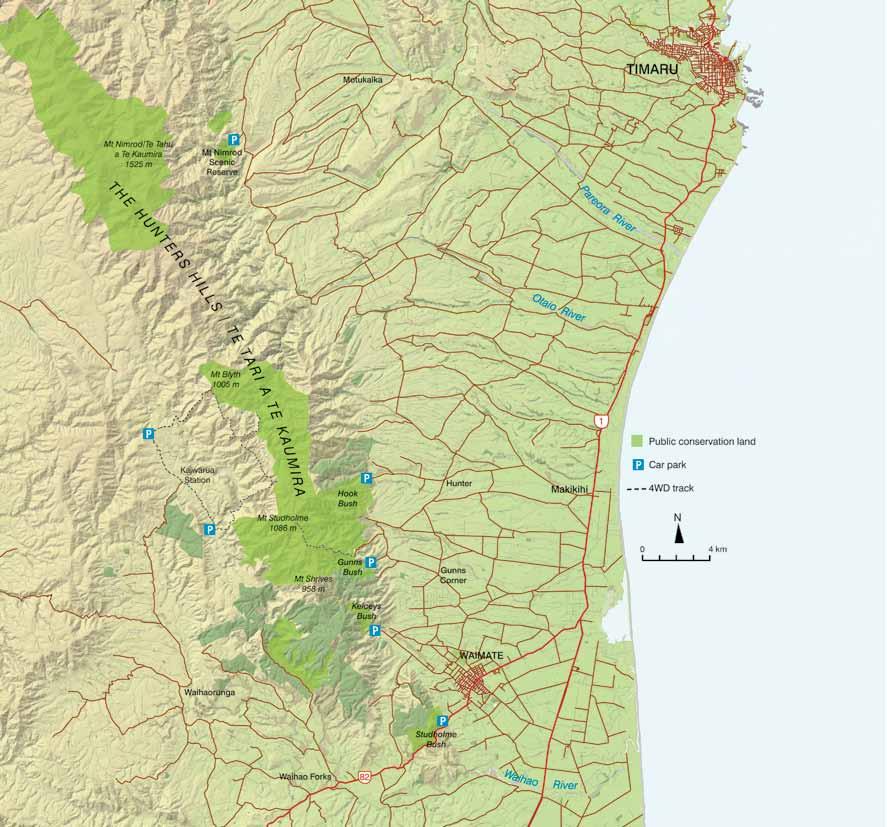
5 6 7
 with great views out over Waimate. Follow State Highway 82 (Hakataramea Highway) from Waimate; after about 3.5 km the car park is on the right of the road.")
6 Studholme Bush Scenic Reserve Enjoy a wide range of tracks, from an easy, fun cycle with the family along Railway Track, to a steep 50-minute walk to the Whitehorse monument (Waimate District Council) with great views out over Waimate. Follow State Highway 82 (Hakataramea Highway) from Waimate; after about 3.5 km the car park is on the right of the road. The reserve is named after Michael Studholme who was the first European settler in Waimate he came to New Zealand with his two brothers in His pastoral lease, 'Te Waimate' was said to be; an estate which Lincoln delegates, after having visited and inspected the land throughout the Colonies, pronounced to be the very finest in New Zealand, if not in the Southern Hemisphere. So rich is a large portion of the land that it is said to be able to carry a bullock to the acre. The reserve was donated to the public by the Gama Foundation in 2008 and then generously gifted to the Department of Conservation to manage in There is a mixture of regenerating podocarp and hardwoods and some coastal species, like ngaio, are present due to the micro climate in the gorge. In December 2010, a fire started by a tree falling on power-lines burnt 154 hectares and took six days to put out. Native bush will again regenerate through the gorse and broom over the coming decades. Mt Ellen 389 m WATERFALL TRACK BELLBIRD TRACK LINK TRACK WHITEHORSE BELLBIRD TRACK QUAIL TRACK RAILWAY TRACK HAKATARAMEA HIGHWAY N NGAIO TRACK metres 82 Dogs are not allowed. Railway Track 30 minutes one way An easy, level track where the family can enjoy pretending to be trains! This former railway from Waimate to Waihao Forks was opened in It stopped taking passengers in 1931 and closed in 1953 due to lack of freight. The 2-km section of railway embankment provides a flat track with Deep Creek on one side and wetlands and regenerating bush on the other. Ngaio Track 35 minutes one way This track climbs steeply after a few hundred metres and provides great views over Waimate and the surrounding country. The numerous ngaio trees are very unusual; these trees are usually found on the coast but here they enjoy the micro-climate in the gorge. Waterfall Track 30 minutes return The waterfall, about 15-m high, is fed by a small stream that may run dry in periods of drought. Follow Railway Track and then walk up Bellbird Track for about 15 minutes until you reach Waterfall Track. 8 9

7 Bellbird Track 45 minutes one way This 2-km walk between Railway Track and the top of Ngaio Track passes through areas of regenerating bush. Quail Track 30 minutes one way Quail Track connects the middle section of Bellbird Track with Railway Track. It provides an alternative route back to the car park. Whitehorse Link Track 15 minutes one way This track connects with Waimate District Council s Centrewood Park and the monument commemorating the Clydesdale horse. Sanders Falls Waimate Creek INTAKE TRACK Rock Pool weir 10 Kelceys Bush Stroll to a small waterfall or picnic along a sparkling stream and listen to the bird song. Access Kelceys Bush is northwest of Waimate. In Waimate turn off Queen Street (Highway 82) onto Mill Road. Follow this road to Kelceys Bush. Kelceys Bush is named after two brothers Julius and Frank Kelcy (the spelling of their name became changed over time) who helped clear the surrounding land after the Waimate fire. Despite milling for firewood and stock grazing, which continued until 1965, Kelceys Bush was a popular picnic spot, particularly in the 1920s and 1930s. In 1901, local MP Sir William Stewards suggested that a portion of Kelceys Bush should be reserved for the preservation of the forest and abundant native bird life; kākā, kererū and tūī. A recommendation was made to the Surveyor General suggesting it would be a mistake to allow this piece of bush to disappear. This forest remnant is mainly broadleaf/kāpuka with mahoe, ribbonwood/mānatu, tree fuchsia/kōtukutuku and occasional kahikatea, mataī and tōtara. A community group, Friends of Kelceys Bush, was formed in 2002 and they are actively engaged in managing and protecting the area. N Toilet metres Dogs are allowed. Sanders Falls Walk 20 minutes return A gentle climb and some steps take you to a viewing platform overlooking the falls. The pipe alongside the track, and at the falls, supplied Waimate s water from 1915 to 1932 when it was discontinued following a major flood. Intake Track 1 hour return This track goes upstream following Waimate Creek past Rock Pool weir. It crosses the creek several times so be prepared to get your feet wet, though thanks to Friends of Kelceys Bush there are concrete stepping stones at most crossings. The pipe alongside the track and the weir at Rock Pool are the remains of Waimate s second water supply, which operated between 1926 and
 from Waimate. Then turn right at Waihao Forks onto Stony Creek Road and then left onto Waihaorunga Road.")
 or right (south east) to reach the signposted public easements across private land to public conservation land. See map page 6.")


8 At Kelceys Bush Mt Studholme Road This unmetalled road is 2WD for about 2.5 km. Just past the old woolshed it becomes a steep, four-wheel-drive single track with precipitous drops to the stream below. Walking access to the western side is reached by following Waimate Kurow Highway (82) from Waimate. Then turn right at Waihao Forks onto Stony Creek Road and then left onto Waihaorunga Road. At Wahaorunga turn right onto Pentland Hills Road. After about 8.5 km this becomes Kaiwarua Road. Follow Kaiwarua Road to its end at Kaiwarua Station woolshed. Just past the woolshed turn either left (north west) or right (south east) to reach the signposted public easements across private land to public conservation land. See map page 6. When driving across farm land please leave gates as you find them and do not block gateways into paddocks. 12 Te Tāpuae a Urihia Mt Blyth, Mt Cecil, Mt Studholme, Mt Shrives This area is in the southern part of The Hunters Hills and lies to the northwest of Waimate. The highest point is Mt Studholme at 1085 m. The vegetation is a mix of broadleaf and podocarp forest on the eastern flanks, which gives way to tussock. Some stream gullies have dracophyllum, matagouri/ tūmatakuru and coprosma. Enjoy extensive views out across the Canterbury Plain. Access Access to the eastern side is from Mt Studholme Road or Jacksons Bush Road. Jacksons Bush Road See the Hook Bush Conservation Area; access section. Dogs are allowed. Gunns Bush Walk along an enchanting moss carpet. Gunns Bush is 10 km northwest of Waimate. From the eastern outskirts of Waimate turn off Timaru Road (SH 82) onto Maytown Road. Take the second right onto Waimate Hunter Road. At Gunns Corner go straight ahead on Upper Hook Road. After about 9 km turn left onto Gunns Bush Road and follow this road past the Christian Camp to the car park at the road end. Dogs are allowed. 13


9 Gunns Bush Track 1 hour 30 min return Moss grows underfoot, making the first part of this walk a magic green carpet. The walk follows the stream and then does a small loop before coming back the same way. There are many large tree-fuchsia/ kōtukutuku which are commonly found in regenerating sites. The kōtukutuku is the largest fuchsia in the world and one of our few native deciduous trees. N metres Hook Bush Conservation Area GUNNS BUSH ROAD Enjoy expansive views out across the Canterbury Plain along an unmarked route up into The Hunters Hills. Access Access to Hook Bush is about 14 km northwest of Waimate. On the eastern outskirts of Waimate turn right off Timaru Road (SH 82) onto Maytown Road. Take the second right onto Waimate Hunter Road and follow this road for about 12.5 km. At Hunter turn left onto Jacksons Bush Road, which is followed to its end. The entrance is marked by the Hook Bush Conservation Area sign. Hook Bush had extensive tracts of tōtara, mataī and miro. It escaped the fire of 1878 and was surveyed in 1880 and freeholded for logging in The bush has some of the best remaining areas of podocarp forest along the The Hunters Hills; it contains mataī which are now rare in Canterbury. The area also has some exceptionally large broadleaf, māhoe and coprosma which may have become established after pre-european fires. 960 m N metres JACKSONS BUSH ROAD Makikihi River Dogs are allowed. Hook Bush Route 1 hour one way An unmarked track leads from the end of Jacksons Bush Road to a stream which is followed for a while before the track ascends to a ridge. This pretty tributary of the Makikihi River is bordered by large kōwhai and lacebark/houhere. Once you leave the stream the route ascends steeply up through thick gorse which in places closely embraces the track long pants recommended! The wide views out to the coast and over Hook Bush Conservation Area make the climb worthwhile. The ridge can then be followed on up to The Hunters Hills and the trig point at 960 m


10 Mt Nimrod Scenic Reserve Note the scenic reserve does not give public access to Mt Nimrod which is on private land. Stay in a tent; walk to see a cascading waterfall and enjoy gorgeous views out to the coast. Camping/picnicing There are sheltered and private picnic and camping sites (20 sites) amongst the bush and grass terraces beside Nimrod Stream. See brochure Conservation Campsites South Island or Dogs are not permitted Mt Nimrod Track 3 4 hour loop track This track has great views and a waterfall that plummets through a rock arch. Just beyond the camping area the loop track takes you on a clockwise circuit of the reserve. Initially it climbs steeply up out of the forest to a lookout point which gives good views out to the coast. The track then drops sharply down to Nimrod Stream which has to be forded. A short detour upstream (watch out for slippery rocks) takes you to a pretty 15-m waterfall cascading through a small rock arch. From here the track climbs again to rocky knolls with great views out over the reserve to the coast. The track then drops back through the forest to the car park. Mt Nimrod Scenic Reserve is on the eastern side of The Hunters Hills. It is 32 km southwest of Timaru and 43 km northwest of Waimate. The reserve is spread over the deep and spectacular gorges of Nimrod Stream and White Rock River. From Timaru follow State Highway 1 south for about 10.5 km. Turn right on Pareora River Road. Just after Pareora Huts turn left on Pareora Gorge Road. At Motukaika monument turn right on Motukaika Road. Turn left on Back Line Road, after about 2 km turn left to the scenic reserve. This area was recognised as important for its birdlife as early as In 1897 the bush was reported to be thick and almost impenetrable, however burning, logging and stock grazing has changed the original forest cover. In 1932 the area was gazetted as a scenic reserve. Nimrod Stream 650 m N metres White Rock River 16 17

11 Protect plants and animals Remove rubbish Bury toilet waste Keep streams and lakes clean Camp carefully Keep to the track Consider others Respect our cultural heritage Enjoy your visit Toitu te whenua (Leave the land undisturbed)
Around and about Geraldine
 Around and about Geraldine A guide to recreational opportunities SOUTH CANTERBURY Track classifications Short walk Easy walking for up to an hour Track is well formed, with an even, welldrained surface.
Around and about Mid-Canterbury
 Around and about Mid-Canterbury A guide to recreational opportunities mid canterbury www.doc.govt.nz Published by Department of Conservation Canterbury Conservancy Private Bag 4715 Christchurch, New Zealand
Discover. Sledge Track Essence of Aotearoa
 Discover Sledge Track Essence of Aotearoa Discover Manawatu s timeless walkway adventure. Lying in the heart of the scenic Kahuterawa Valley, Sledge Track brings you face to face with the majesty of New
East West route and Leatham Molesworth route (route guide) Molesworth Recreation Reserve
 Molesworth Recreation Reserve") East West route and Leatham Molesworth route (route guide) Molesworth Recreation Reserve 0BIntroduction The East West route links the Clarence (Kahutara River in Ka Whata Tu o Rakihouia) Conservation Park
East West route and Leatham Molesworth route (route guide) Molesworth Recreation Reserve 0BIntroduction The East West route links the Clarence (Kahutara River in Ka Whata Tu o Rakihouia) Conservation Park
Discover... Sledge. Track. Essence of Aotearoa. You ll find there s much more than meets the eye!
 Sledge Discover... Track Essence of Aotearoa You ll find there s much more than meets the eye! Discover... Manawatu s timeless walkway adventure. Lying in the heart of the scenic Kahuterawa Valley, Sledge
The Aotea Track offers a range of spectacular landscapes, superb views and rich history.
 Aotea Track Located in Great Barrier Island/Aotea in the Auckland region The Aotea Track offers a range of spectacular landscapes, superb views and rich history. Travel over streams that show off a constant
Difficult Run Stream Valley Park
 Difficult Run Stream Valley Park The more intense mountain bikers have known about for Difficult Run for some time. Equestrians have known it longer. Eight miles of unpaved trail, the Rails to River Trail
Discover. Ashhurst Domain. Nature s Playground
 Discover Ashhurst Domain Nature s Playground Discover Step back into New Zealand, Aotearoa, of generations long gone. Discover lush natural surrounds echoing with rich birdsong in one of the Manawatu s
CWMGIEDD FROM ABERCRAVE
 Abercrave to Cwmgiedd Walk Page 1 Starting from The Abercrave Inn. Grid Ref: SN 824128 From the Abercrave Inn, an 11.3km (7 miles) walk to the foothills of the Cribarth Mountain, then through forest to
Guthega to Mt Twynam. 2183m. 1583m. 6 hrs 45 mins 14.8 km Return. Experienced only. 913m
 Guthega to Mt Twynam 6 hrs 45 mins 14.8 km Return Experienced only 5 913m This walk starts from Guthega and makes its way along the Snowy River to the Illawong Lodge, via the Blue Cow Creek flying fox.
GIFFORD PINCHOT NATIONAL FOREST
 GIFFORD PINCHOT NATIONAL FOREST 9341 Wright Meadow 93 Spencer Meadow Spencer Butte 4247' 30 30A 19 24 80 31C Lewis River Lower Falls 5 Quartz Creek 90 Taidnapam Falls Upper Falls 31 Spencer Peak 3861'
IRON BARK and COLENSO HUTS 260 Series Map: 1:50, U21 NZ Grid GPS: Geodetic Datum 1949
 IRON BARK and COLENSO HUTS 260 Series Map: 1:50,000 260-U21 NZ Grid GPS: Geodetic Datum 1949 Topo50 Map: BK36 Taoroa Junction GPS: on WGS84 How to get to START: Exit Taupo on SH1 down the lake to Turangi
GOLDEN EARS PROVINCIAL PARK
 GOLDEN EARS PROVINCIAL PARK Trail Information as of October 10 th 2015 Do not underestimate the mountainous wilderness of Golden Ears Provincial Park. The combination of rugged terrain and rapidly changing
Asheville & WNC Hikes
 Asheville & WNC Hikes Amazingly, we have 3,000+ miles of free public hiking trails near Asheville, including 1,600 miles in the Pisgah and Nantahala National Forests, 850 miles in Great Smokey Mountains
Reservoir Tin workings
 The workings are quite over-grown and covered in moss, suggesting that they date to the earliest period of mining. This is supported by the fact that their head race was cut off by the reservoir (D49/47)
Congewai Track Head (East) to Watagan Headquarters
 to Watagan Headquarters") Congewai Track Head (East) to Watagan Headquarters 7 hrs Hard track 17.2 km One way 4 973m This full day walk starts from the Congewai valley trackhead (east) and follows the Great North Walk up into the
Congewai Track Head (East) to Watagan Headquarters 7 hrs Hard track 17.2 km One way 4 973m This full day walk starts from the Congewai valley trackhead (east) and follows the Great North Walk up into the
Mt Kuring-gai Track to Berowra station
 Mt Kuring-gai Track to Berowra station 4 hrs 15 mins 9.7 km One way Hard track 4 553m This walk explores three valleys, with great displays of wild flowers in spring, and some nice sandstone overhangs.
Note: Coordinates are provided as Universal Transverse Mercator UTM Zone U21, North American Datum 1983 (NAD 83).
.") Northern Traverse Route Description The Northern Traverse (formerly the North Rim Traverse) is an unmarked and rugged backcountry hiking route. It is known be a demanding hike, because of its terrain and
Northern Traverse Route Description The Northern Traverse (formerly the North Rim Traverse) is an unmarked and rugged backcountry hiking route. It is known be a demanding hike, because of its terrain and
Erskine Creek via Pisgah Rock and Jack Evans
 Erskine Creek via Pisgah Rock and Jack Evans 4 hrs 30 mins 7.1 km Circuit Very experienced only 6 421m This walk visits some great lookouts and explores the lower section of Erskine Creek. Most of the
Trail Beginning Elevation: 7553 ft The Poison Creek Trailhead is located at the end of National Forest Road 646E (NF-646E).
.") West Mountain Trails Poison Creek Trail #134 Length: 2.9 miles (4.7 km) Difficulty Horseback: A good trail for the first time west mountain rider, some steep sections Hiking: Most Difficult USGS Maps:
West Mountain Trails Poison Creek Trail #134 Length: 2.9 miles (4.7 km) Difficulty Horseback: A good trail for the first time west mountain rider, some steep sections Hiking: Most Difficult USGS Maps:
Angelus Hut Tracks and Routes NELSON LAKES NATIONAL PARK
 Angelus Hut Tracks and Routes NELSON LAKES NATIONAL PARK Contents Introduction 1 Can I do it? 1 Location 3 Getting there 4 Walking seasons 4 Hut and campsite 5 Hut etiquette 6 History 7 Planning, preparation
Trail Phasing Plan. Note: Trails in the Clear Creek Canyon area (Segments will be finalized in the future to minimize wildlife impacts
 Note: Trails in the Clear Creek Canyon area (Segments 2 5 and a future JCOS connection) will be finalized in the future to minimize wildlife impacts Trail Phasing Plan P Parking 3 Easy Trail Intermediate
Abbotts Falls Walking Track
 Abbotts Falls Walking Track 3 hrs 7.3 km Circuit Hard track 329m This circuit takes you through both dry and moist forest, using a combination of walking trails and wider tracks. The side trip to the dammed
County Line trail - Miller Peak to Little Navaho
 County Line trail - Miller Peak to Little Navaho 7-17-2008 This hike features a portion of the County Line trail in the Teanaway that receives extremely little use despite offering a spectacular ridge-run
Ngaio Walking Tracks map 1
 Skyline Walkway Part of this walkway runs north-south along the ridge between Mt Kaukau and Crofton Downs. It is 4 km long and takes two hours at an easy pace. On a clear day there are spectacular views
Self-Guided Walk Langdale Pikes. Start & Finish: NT car park (free to members) at Sticklebarn - on the right just beyond the New Dungeon Ghyll hotel.
 at Sticklebarn - on the right just beyond the New Dungeon Ghyll hotel.") Self-Guided Walk Langdale Pikes Key Information These mountains form a collection of spires and cliffs on the north side of Langdale. This walk visits four of the main tops Pavey Ark, Harrison Stickle,
Self-Guided Walk Langdale Pikes Key Information These mountains form a collection of spires and cliffs on the north side of Langdale. This walk visits four of the main tops Pavey Ark, Harrison Stickle,
Glenhope. Lewis Pass Highway, North Canterbury 9,295 hectares
 Glenhope Lewis Pass Highway, North Canterbury 9,295 hectares Contents 1. Introduction 2. Homestead 3. Farm buildings, Contour 4. Stock, Soils 5. Subdivision, Cover, Water Supply, Rainfall 6. Access, Services,
Park-specific management and policies Wainuiomata Recreation Area
 Park-specific management and policies Wainuiomata Recreation Area 6.8 Wainuiomata Recreation Area 6.8.1 Legal status Title held: Legislative status: Wellington Regional Council Administered under Local
Skiing and Snowshoes on Un-groomed Fernan Saddle Terrain
 Skiing and Snowshoes on Un-groomed Fernan Saddle Terrain Three ski or snowshoe routes are available from the Fernan Saddle Parking Lot which either do not cover routes ordinarily groomed for snow machine
Listing of Campsites on the Manigotagan River
 Listing of Campsites on the Manigotagan River This document lists and describes the campsites along the Manigotagan River between Highway #314 and the government dock in the community of Manigotagan. The
1. Waterfall Gully Mt Lofty. 5 Of the Best Hikes in Adelaide
 Adelaide is a beautiful city, and one of the most incredible things about Adelaide is the quality of bushwalking available on the suburban fringe. It is surrounded by the Mt Lofty Ranges, and much of the
Rogue Gorge (Mt. Stella) Roadless Area-- T30S R3E (primarily in portions of Sections 23, 26, 33, 34 & 35)
 Roadless Area-- T30S R3E (primarily in portions of Sections 23, 26, 33, 34 & 35)") Rogue Gorge (Mt. Stella) Roadless Area-- T30S R3E (primarily in portions of Sections 23, 26, 33, 34 & 35) Rogue River-Siskiyou National Forest--High Cascades Ranger District Upper, higher elevation trail
Rogue Gorge (Mt. Stella) Roadless Area-- T30S R3E (primarily in portions of Sections 23, 26, 33, 34 & 35) Rogue River-Siskiyou National Forest--High Cascades Ranger District Upper, higher elevation trail
Brinker Creek Ranch. Colorado - Routt County - Yampa
 Located at the base of the Flattops Range in the Steamboat/Vail corridor, Brinker Creek Ranch consists of 1,451 acres ideally suited for high country grazing and native grass hay production. Traditionally
Walking tracks. in Aoraki/Mount Cook National Park
 Walking tracks in Aoraki/Mount Cook National Park Contents Welcome to Aoraki/Mount Cook National Park 1 Be prepared 3 Walks from the village and campground 5 Freda du Faur 9 Walks map 10 Village walks
Dadder Cave and Jack Evans track
 Dadder Cave and Jack Evans track 2 Days 10.3 km Circuit Very experienced only 535m This fairly short overnight walk is a great way to explore Erskine Creek. The walking along Erskine creek is mostly off
Exploring the Dumaresq River
 Exploring the Dumaresq River The Dumaresq River (dew merrick) lies on the western side of the Great Dividing Range, the continuous line of mountains that flanks the entire east coast of Australia. The
The gorges of Mohican Park in Ohio create a hiker's paradise Sunday, May 22, 2011 By Bob Downing, Akron Beacon Journal
 Pittsburgh Post-Gazette The gorges of Mohican Park in Ohio create a hiker's paradise Sunday, May 22, 2011 By Bob Downing, Akron Beacon Journal Bob Downing Big Lyons Falls drops 80 feet into a shady U-shaped
NOHOANGA SITE INFORMATION SHEET TUCKERS BEACH, OTAGO. Tuckers Beach Road. Entry Point to Site. Getting there
 NOHOANGA SITE INFORMATION SHEET TUCKERS BEACH, OTAGO Getting there This site is within the Tuckers Beach Wildlife Reserve, at approximately 280 Tuckers Beach Road, 15mins drive north of Queenstown township.
Staples Lookout to Mt Wondabyne loop
 Staples Lookout to Mt Wondabyne loop 4 hrs 3 mins 1.8 km Circuit Hard track 337m This walk starts and finishes at Staples Lookout, on Woy Woy Rd. The walk follows sections of the Great North Walk around
beach. Make the ford and follow the trail out to the junction with Red Creek Tr in an open grassy area.
 Description: This is a moderate to slightly strenuous 22.8 mile backpack (add 2.6 miles if you do the packless out and back to the Lion s Head) that will have you exploring nearly every thing that is The
Countryside Trails Dunkeld
 R A N G E R S E RV I C E Countryside Trails Dunkeld WELCOME Welcome to this southern end of Atholl Estates. The countryside here is a wonderful blend of lochs, woodland and heather moor. There is a large
Location: 7km west of Invercargill on Dunns Road
 SANDY POINT DOMAIN Sandy Point Domain offers the Invercargill community important environmental and recreational resources providing opportunities for picnicking, play, walking, biking, running and as
The Mendip Way. Route Directions and Maps Uphill to Wells
 The Mendip Way Route Directions and Maps Uphill to Wells Website: www.mendiphillsaonb.org.uk Email: mendip@mendiphillsaonb.org.uk Facebook & Twitter: @MendipHillsAONB Phone: 01761462338 1 Uphill to Loxton
F.O.K.O.S. Friends of Kingston Open Space A GUIDE TO KINGSTON OPEN SPACE
 F.O.K.O.S. Friends of Kingston Open Space A GUIDE TO KINGSTON OPEN SPACE Friends of Kingston Open Space (FOKOS) was formed when a handful of concerned citizens joined together to learn what could be done
(WP19178masl) where the left branch is taken. Within 50min 300m are ascended. Start of the track shelter. Level grassy area
 where the left branch is taken. Within 50min 300m are ascended. Start of the track shelter. Level grassy area") SOUTHERN CROSSING 260-Series: Levin S25, S26 Carterton NZ Grid GPS: Geodetic datum1949 Topo50 Map: BP33 Featherstone NZTM GPS: NZTM on WGS 84 How to get to START: The motor camp in Levin makes a good overnight
SOUTHERN CROSSING 260-Series: Levin S25, S26 Carterton NZ Grid GPS: Geodetic datum1949 Topo50 Map: BP33 Featherstone NZTM GPS: NZTM on WGS 84 How to get to START: The motor camp in Levin makes a good overnight
CIEC 9 PEAKS AWARD SUPPLEMENT POSSIBLE ROUTES FOR THE 9 PEAKS AWARD TRIP
 CIEC 9 PEAKS AWARD SUPPLEMENT POSSIBLE ROUTES FOR THE 9 PEAKS AWARD TRIP As you plan your trip, be aware of 3 regulations in this wilderness: 1. Camp only in designated campsites. 2. No campfires allowed.
Other Agencies and Organizations
 Daniel Boone National Forest 1700 Bypass Road WInchester, KY 40391 859-745-3100 Location Northern terminus is near Morehead, Kentucky. Southern terminus is located in the Big South Fork NRRA in Tennessee.
Out and about at Geehi
 Geehi Geehi Flats is a large area of flat floodplain on the banks of the Swampy Plains River. Located within Kosciuszko National Park, it is home to a popular campsite in summer for people wanting to enjoy
Illawarra Escarpment State Conservation Area Walking Tracks
 Illawarra Escarpment State Conservation Area Walking Tracks NPWS Illawarra Area Office Ground Floor, Government Office Block 84 Crown Street Wollongong NSW 2500 02 4223 3000 (Mon-Fri) Royal National Park
Crystal Lake Area Trails
 Lake Area Trails Welcome to the Lake area of the Big Snowy Mountains! This island mountain range in central Montana features peaks reaching to 8,600 feet and long, high ridges from which vistas of the
Black Hill Regional Park, Little Seneca Lake
 Black Hill Regional Park, ittle Seneca ake ittle Seneca ake, in Black Hill Regional Park, is a reservoir created after a previous drought struck the Washington area. The park is under Maryland-National
Girrakool to Wondabyne station via Pindar caves
 Girrakool to Wondabyne station via Pindar caves 7 hrs 30 mins 18.1 km One way Experienced only 5 741m This walk starts from the Girrakool picnic area and winds south, following Piles creek into the Brisbane
Southern Utah University Hike Brochure
 Southern Utah University Hike Brochure Taylor Creek Trail Twenty minutes from Cedar City Red Hollow An hour and a half from Cedar City Fees: Entrance fee to Kolb Canyon Length: 5 miles round trip Length:
Stephens State Park Trails
 TRAILS OF ALLAMUCHY MOUNTAIN & STEPHENS STATE PARKS Allamuchy Mountain and Stephens State Parks contain 28 marked trails providing access to diverse landscapes for walking, hiking, biking, bird-watching,
Drive and Stop Routes
 Drive and Stop Routes Limantour Road 1 - easy and likely productive. From Bear Valley Visitor Center drive back out and turn left onto Bear Valley Rd. Turn left at Limantour Road (the first road). Drive
Best Hikes on Orcas Island
 Published on San Juan Islands Washington Visitors Bureau Orcas Island Lopez Island Friday Harbor San Juan Island (https://www.visitsanjuans.com) Best Hikes on Orcas Island The Emerald Isle offers big trees,
Girrakool to Wondabyne station
 Girrakool to Wondabyne station 4 hrs Hard track 9.5 km One way 4 438m This walk starts from the Girrakool picnic area and winds south, through the Brisbane Waters National Park. The walk crosses some long
Little Grand Canyon near Pomona, Illinois
 Little Grand Canyon near Pomona, Illinois Below: View of the trail and the terrain created using the Map My Hike app Below: Summary of the hike created using the Map My Hike app Presented by: Jennifer
Kuruwita Erathna Trail to Sri Pada (Adam s Peak)
") Kuruwita Erathna Trail to Sri Pada (Adam s Peak) Trail Difficulty: Easy Moderate Strenuous Tough Trail Head: Adevikanda, Erathna (near entrance to mini-hydro power plant) Nearest Town: Erathna Nearest
Kuruwita Erathna Trail to Sri Pada (Adam s Peak) Trail Difficulty: Easy Moderate Strenuous Tough Trail Head: Adevikanda, Erathna (near entrance to mini-hydro power plant) Nearest Town: Erathna Nearest
Jackson Miles Abbott Wetlands Refuge/Fort Belvoir
 Jackson Miles Abbott Wetlands efuge/fort Belvoir Over the course of millions of years the Potomac iver has gradually shifted its course and sediments have filled-in its old river bed. The main river once
Sunday / Monday - Osceolas
 AMC August 3, 2015 Sunday / Monday - Osceolas 0 1737 ft 2007, Appalachian Mountain Club. All rights reserved. Notes Created by AMC White Mountain Guide Online wmgonline.org 1 Distance Time Elev Change
TRAVEL WITH CHRIS BROWN
 TRAVEL WITH CHRIS BROWN ARKABA STATION In South Australia's magnificent Flinders Ranges, one eco tourism company is doing their bit to protect native wildlife. Arkaba Station was once a sheep station but
ROAD SCHOLAR SPRING HIKING ADVENTURE Tentative Schedule April 8-13, 2018
 Sunday, April 8 ROAD SCHOLAR SPRING HIKING ADVENTURE Tentative Schedule April 8-13, 2018 PM 3:00-5:00 Arrival, registration and move in to the dorm. 6:00 Supper EVE 7:00 Welcome & Orientation, Sign Ups
middle left: Riversleigh fossils lower left: Constance Range images: Hj Preuss... Thx
 Upstreampaddle Summer 2008 18 middle left: Riversleigh fossils lower left: Constance Range images: Hj Preuss... Thx top right: road west of the Isa middle right: Constance Range lower right: rocky outcrop
FORGOTTEN WORLD HIGHWAY
 FORGOTTEN WORLD HIGHWAY New Zealand s oldest heritage trail between Taumarunui and Stratford An initiative of New Plymouth District Council FORGOTTEN WORLD HIGHWAY Don t forget Drive on the LEFT at all
Koroc River Palmer River Loop
 parkscanada.gc.ca Multi-Day Hiking Route Koroc River Palmer River Loop Torngat Mountains National Park T. Knight, Parks Canada 425000m.E. 64 15'0"W 30 64 10'0"W 35 64 5'0"W 40 64 0'0"W 45 63 55'0"W 50
Magoebaskloof Hiking Trail
 Magoebaskloof Hiking Trail Location The Magoebaskloof Hiking Trail is near the town of Tzaneen in the Limpopo Province. How to get there To Woodbush Hut. From Gauteng, take the N1 North towards Polokwane
Significant Natural Area Assessment. Property Name: Hillend Station
 Private Bag 50072, Queenstown 9348, New Zealand QUEENSTOWN, 10 Gorge Road, Phone +64 3 441 0499, Fax +64 3 450 2223 WANAKA, 47 Ardmore Street, Phone +64 3 443 0024, Fax +64 3 450 2223 Significant Natural
Beautiful Walks from the Blue Ball Inn
 Walk No. 5 RIVER VALLEYS AND MOOR Countisbury, Watersmeet, Hillsford Bridge, Cheriton, Shilstone Hill, Rockford and Chiselcombe. 8.5 MILES APPROX. Walking time four and a half hours approx. OS 1;25,000
Leaden Boot Challenge ROUTE INSTRUCTIONS
 Leaden Boot Challenge ROUTE INSTRUCTIONS Section 1 Alstonefield to Ilam From the village hall car park turn R then L and pass through the village keeping to the R to enter Church Street. Pass the Church
Welcome to Natural Bridge
 Welcome to Natural Bridge Richard R. Randolph IV www.r4capital.com Www.r4land.com 205-879-5517 Work 205-413-8805 Fax 6 Carla Circle Birmingham, AL 35213 rich@r4capital.com Introduction NATURAL BRIDGE 160
Victoria Falls and Grose Valley to Blackheath Station
 This walk explores a fantastic section of the Grose Valley. Starting above Victoria Falls, the walk explores the cascades before dropping into the valley for the first nights rest at Burra Korain campsite.
Pontfadog. Walk A. Walk A
 Walk A A Bird s eye view of the village 2km. (1 1 /2 miles); height gain 45m. (150ft) about 45 minutes. Six minutes walk along the main road towards Glyn Ceiriog reach a signpost to Llwynmawr. Take the
ABOUT THE PARKS NANTAHALA NATIONAL FOREST MOUNTAINS NATIONAL PARK CHEROKEE NATIONAL FOREST PISGAH NATIONAL FOREST GREAT SMOKY HIKING TRAILS
 ABOUT THE PARKS GREAT SMOKY MOUNTAINS NATIONAL PARK NANTAHALA NATIONAL FOREST CHEROKEE NATIONAL FOREST PISGAH NATIONAL FOREST GREAT SMOKY MOUNTAINS NATIONAL PARK Straddling the border between North Carolina
Outdoor property Access Statement Box Hill, Surrey
 Outdoor property Access Statement Box Hill, Surrey Box Hill Tadworth, Surrey. KT20 7LB T: 01306 888793 T: Rangers 07770 887673 or 07770 887674 E: boxhill@nationaltrust.org.uk Introduction This property
Segment 2: La Crescent to Miller s Corner
 goal of the USFWS refuges is to conserve, protect and enhance fish, wildlife and plants and their habitats for the continuing benefit of the American people. Refuge lands are used largely for fishing,
ROBERTS CREEK PROVINCIAL PARK MASTER PLAN. November, 1981
 Ministry of Lands, Parks and Housing Parks and Outdoor Recreation Division Park Operations Branch North Vancouver, B. C. ROBERTS CREEK PROVINCIAL PARK MASTER PLAN November, 1981 Mr. G. Trachuk Director
Merritts Traverse. 1928m
 Merritts Traverse 3 hrs Hard track 5.8 km Circuit 4 167m This walk starts with a scenic journey to the top of the hill on the chairlift. Starting along Merritts Nature walk, this walk soon detours down
Lake Wissota Access Locations within the LaFayette Township. By Chad Martin
 Lake Wissota Access Locations within the LaFayette Township By Chad Martin Anson/ Wissota Access Point # 1 Road: 195 th St. Associated Fire Numbers: 13294 Defining Characteristics: Forested from road
TAYLOR CANYON RANCH COLORADO - ROUTT COUNTY - STEAMBOAT SPRINGS
 TAYLOR CANYON RANCH COLORADO - ROUTT COUNTY - STEAMBOAT SPRINGS Tucked up against the steep valley shaped by Mt. Pau and rising to the Routt National Forest, Taylor Canyon Ranch is an easily accessible,
18Day Road Tour Christchurch to Christchurch
 18Day Road Tour Christchurch to Christchurch Route: Christchurch Farlie Lake Tekapo Twizel Wanaka Queenstown - Te Anau Milford Sound - Manapouri Queenstown Wanaka Haast Fox Glacier Franz Josef Hokitika
Guthega to Thredbo camping overnight at Wilkensons Creek
 Guthega to Thredbo camping overnight at Wilkensons Creek 2 Days Experienced only 25.8 km One way 5 1364m This great overnight walk explores the Kosciusko National Park between Guthega and Thredbo, visiting
This Passport: Revised October 20, 2017, EAM # Discovering the Trails of Penfield, NY
 This Passport: Revised October 20, 2017, EAM #161922 Discovering the Trails of Penfield, NY The Town of Penfield is fortunate to have a wide variety of natural resources which make for many unique and
Victoria Falls Lookout to Blue Gum Forest
 Victoria Falls Lookout to Blue Gum Forest 8 hrs Experienced only 13.8 km One way 5 112m This long day-walk follows a remote track down from Victoria Falls lookout, passing the waterfall, and into the Grose
Colorado Life Zone Scavenger Hunt
 Colorado Life Zone Scavenger Hunt Below are worksheets created for all the habitats or life zones. They were designed with the intention of breaking the class up into small groups, and having students
e-news TRACK REGENERATION WORK AT DINGO DELL, WEST OF SYDNEY.
 e-news TRACK REGENERATION WORK AT DINGO DELL, WEST OF SYDNEY. By the project coordinator, Matt Barnes, Public Relations Officer for the Land Rover Owners Club of Australia (Sydney Branch) Inc One of the
Mobile Safari Laikipia to Western Kenya 10 Nights
 Mobile Safari Laikipia to Western Kenya 10 Nights This is a private guided safari led by Steve Carey or another highly experienced guide. The safari is by road in a custom-made Toyota Landcruiser focusing
Nature Track. 900m. 789m. 2 hrs 3.1 km Circuit. Hard track 238m. Blue Mountains National Park
 Nature Track 2 hrs 3.1 km Circuit Hard track 238m Largely following the ridges around the top edge of Wentworth Falls, this track is incredibly beautiful. After taking in the great views at Edinburgh Castle
Camping (Primitive) Camping (RV) Electrical Potable Water Grill Established Fire Pit Picnic Table
 Camping (RV) Electrical Potable Water Grill Established Fire Pit Picnic Table") Alden - 9th Road River Mile 777 Map: 38.20833, -98.32031 Managing Agency: Kansas Department of Wildlife, Parks & Tourism Nearest Community: Alden, Rice County Kansas Developed Amenities Provided Parking
Alden - 9th Road River Mile 777 Map: 38.20833, -98.32031 Managing Agency: Kansas Department of Wildlife, Parks & Tourism Nearest Community: Alden, Rice County Kansas Developed Amenities Provided Parking
ROAD SCHOLAR SPRING HIKING ADVENTURE Tentative Schedule April 9-14, 2017
 ROAD SCHOLAR SPRING HIKING ADVENTURE Tentative Schedule April 9-14, 2017 Sunday, April 9 PM 3:00-5:00 Arrival, registration and move in to the dorm. 6:00 Supper EVE 7:15 Welcome & Orientation, Sign Ups
Hiking Trail Descriptions
 Hiking Trail Descriptions For ye shall go out with joy. And be led forth with peace. The mountains and the hills shall break forth before you in singing. And all the trees of the fields shall clap their
BUTCHER CREEK RANCH. Butcher Creek Ranch. Roscoe, Montana. Reduced to $1,650,000.
 BUTCHER CREEK RANCH Butcher Creek Ranch Roscoe, Montana Reduced to $1,650,000. Offered Exclusively By: Sonny Todd Real Estate 301 West First Avenue, PO Box 788 Big Timber, Montana 59011 Office: (406) 932-1031
Roduner Ranch FOR SALE. 5,878± Acres Potential Development Land. Merced County, California. Offices Serving The Central Valley
 FOR SALE 5,878± Acres Potential Development Land Merced County, California Offices Serving The Central Valley F R E S N O V I S A L I A B A K E R S F I E L D 7480 N. Palm Ave, Ste 101 3447 S. Demaree Street
SAN MIGUEL CREEK RANCH. q Trinidad, Las Animas County, Colorado q
 SAN MIGUEL CREEK RANCH q Trinidad, Las Animas County, Colorado q 2 s San Miguel Creek Ranch is a scenic well-balanced cattle and trophy hunting ranch that showcases the very best of Southern Colorado.
On the right track Esk to Toogoolawah 19 km
 www.brisbanevalleyrailtrail.org.au On the right track Esk to Toogoolawah 19 km rail summar Location Trail summary The Brisbane Valley Rail Trail, when completed, will be a 148 kilometre recreation trail
Ponderosa Pines Ranch
 PONDEROSA PINES RANCH Ponderosa Pines Ranch Shepherd, Montana $3,285,000. Offered Exclusively By: Sonny Todd Real Estate 301 W First, PO Box 788 Big Timber, MT 59011 Office: (406) 932-6668 (406) 932-LAND
Jerusalem Bay Track (Cowan to Brooklyn)
") Jerusalem Bay Track (Cowan to Brooklyn) 5 hrs 30 mins 13.4 km One way Hard track 4 654m This Cowan to Brooklyn Station walk is a popular section of the Great North Walk, with scenery ranging from foreshore
Jerusalem Bay Track (Cowan to Brooklyn) 5 hrs 30 mins 13.4 km One way Hard track 4 654m This Cowan to Brooklyn Station walk is a popular section of the Great North Walk, with scenery ranging from foreshore
Walking Track Classification System Parks and Wildlife Service
 Appendix A Walking Track Classification Specifications Walking Track Classification System Parks and Wildlife Service This Walking Track Classification System is the outcome of a review of the track classifications
CELEBRATE WEST GREENWICH GEOCACHING THROUGHOUT WEST GREENWICH
 CELEBRATE WEST GREENWICH GEOCACHING THROUGHOUT WEST GREENWICH The West Greenwich Land Trust (WGLT) is sponsoring Celebrate West Greenwich, an event designed to celebrate the beauty and history of scenic
Trail Assessment Report
 Trail Assessment Report Trail Options for the Bear Creek Canyon located in Pikes Peak Ranger District, Pike National Forest and on Colorado Springs Utility Lands Due to the presence of a unique species