The Illawarra Bicycle Users Group s Guide to cycling in the Illawarra
|
|
|
- Helena McKenzie
- 5 years ago
- Views:
Transcription

1 The Illawarra Bicycle Users Group s Guide to cycling in the Illawarra Compiled by Werner Steyer First edition September th revision August 2011
2 Copyright Notice: W. Steyer 2010 You are welcome to reproduce the material that appears in the Tour De Illawarra cycling guide for personal, in-house or non-commercial use without formal permission or charge. All other rights are reserved. If you wish to reproduce, alter, store or transmit material appearing in the Tour De Illawarra cycling guide for any other purpose, request for formal permission should be directed to W. Steyer 68 Lake Entrance Road Oak Flats NSW 2529
3 Introduction This cycling ride guide and associated maps have been produced by the Illawarra Bicycle Users Group incorporated (ibug) to promote cycling in the Illawarra. The ride guides and associated maps are intended to assist cyclists in planning selfguided outings in the Illawarra area. All persons using this guide accept sole responsibility for any losses or injuries uncured as a result of misinterpretations or errors within this guide Cyclist and users of this Guide are responsible for their own actions and no warranty or liability is implied. Should you require any further information, find any errors or have suggestions for additional rides please contact us at Updated ride information is available form the ibug website at As the conditions may change due to road and cycleway alteration by Councils and the RTA and weather conditions cyclists must be prepared to change their plans and riding style to suit the conditions encountered. As the Illawarra is a narrow coastal strip, sandwiched between the Pacific Ocean and the Illawarra Escarpment, many of the rides are described as one way rides and riders need to retrace the route for the return journey. Alternately people can utilize trains to reach the start of rides or for the return trip, please remember to check that trains are running, as buses used during periods of track work don t have provision for bicycles. Many of the rides described can be linked to make longer rides to match your riding needs. Visitors to the area, with limited time, may wish to enjoy the best of the Illawarra s cycling facilities and scenery by catching a train to either Kiama or Thirroul and riding the coastal route in one direction. Riders should consult the weather forecast and plan to use the wind to their advantage. The maps associated with the various rides are intended to depict the rides and location on shared path and cycling lanes. In addition to the ibug maps riders should carry an area map, such as the UBD Wollongong Map, to aid in navigation and find streets not shown on the ibug maps Distances shown in ride descriptions, (7.3 km), are approximate distances form the start of the ride. The start and finish of rides is depicted by a blue dot with the ride number. The start and finish of rides are generally located in parks, where there is space to park cars. Many of the rides also start and finish near railway stations to give cyclist the option of using trains to join the rides.

4 Safety: Know and follow the Rules: All riders must have an understanding of the road rules pertaining to cycling; see the RTA web site at for further information. Wear a Helmet: Cyclists must wear an approved helmet while riding, including riding on Shared Use Paths and cycleways. Be Safe be Seen: Wear bright coloured clothing so others can see you and a rear flashing light Share the Path: Follow the Shared Use Path etiquette and make our paths a joy for all to share Use 000 in Emergencies If using a mobile phone try 112 if you phone has no reception (this is the international emergency number and will be relayed by any phone carrier visit for more information) Police Stations Only Wollongong and Oak Flats stations are maned 24/7 other stations have limited hours of operation. The Illawarra Police command has been relocated to the new station adjacent to Oak Flats Railway Station Note: the old Warilla Police Station is no longer in use and is unattended. Helensburgh Scarborough Austinmer Bulli Wollongong Port Kembla Dapto Oak Flats Albion Park Kiama Gerringong
5 Help make cycling safer for all by report cycling hazards Reporting cycling through the NSW Bicycle Information website will provide a coordinated response without the need to understand who is responsible for taking action. is a direct link to reporting hazards within the Bicycle information website. To report urgent hazards please ring the local councils and the RTA as the above system is slow to respond to emergencies. RTA Wollongong Council Shellharbour Council You can also help other cyclists by posting hazard information on our traffic report page at or sending the information to contactus@ibug.org.au Spares and repairs While there are a number of cycle stores in the district they are not all open on weekends and cyclist should carry spare tubes, puncher repair kits and tools on all rides. In addition to the cycling speciality store some of the department stores and sports stores also carry a limited supply of cycle parts such as tyres, tubes and basic parts and as they have longer trading hours they may help in an emergency when the cycle stores are closed. Cycle Shops Avantiplus Wollongong Illawarra Cycles & Sports Corrimal Kiama Cycles & Sports Kiama Spearman Cycles West Wollongong Steel City Cycle Works Thirroul Wilson s Bike Hub Albion Park Rail Wilson s Bike Hub Dapto Wilson s Bike Hub Warrawong Wilson s Bike Hub Wollongong
6 Ride Grading: Easy: Rides indicated as easy are rides which predominately use Shares Use Path and back streets and have few long steep hills unless stated in the ride descriptions. The rides are suitable for people of average fitness and limited cycling experience. Be prepared to walk on steep hills. Moderate: These rides could have sections of heavy road traffic, some steep hills and are more suited to riders with experience at riding on roads as they have a grater interaction with general road users Hard: These rides will be predominately on roads with section of multi-lane fast moving traffic and with long steep hills to negotiate. Extreme: Riders can expect numerous long steep hill roads with heavy fast moving traffic and the rides are suitable only to people used to riding under those conditions Who is ibug? ibug is the Illawarra Bicycle User Group incorporated. We are local people who enjoy cycling. Members vary in cycling skills, age, fitness level, motivation for cycling and style of bike. We ride for a variety of reasons - fun, exercise, sport, leisure, commuting and touring. ibug is also involved in cycle advocacy: lobbying for improvements to cycling facilities, the environment and safety. We liaise with Wollongong and Shellharbour Councils, write submissions and are happy to work with others in the local area on cycling issues. Why join ibug? By joining ibug you help build a strong voice for cycling in the Illawarra. The bigger our membership list the greater our voice on behalf of cycling. Membership also means you will be kept informed of any developments in cycling at the local, state, national and international levels. Become a member and ensures you have a voice. See membership information on our website or contact us at contactus@ibug.org.au for more information
7 Overview and Short Descriptions ibug Ride Wollongong to Windang via Port Kembla Distance: 23 Km Grade: Easy 001 This is an easy scenic ride mostly on shared path and back streets following the coast and through the industrial area. ibug Shellharbour City Circuit Ride. Ride Distance: 28 Km Grade: Moderate 002 Suitable to most riders, a mixture of shared cycle ways and back streets with two small sections on unpaved grass tracks. ibug Oak Flats Station to Dunmore and Killalea Ride Distance: 13 Km Grade: Easy 003 Predominately on back roads and shared path and avoids the busier main roads, with a short section of Shellharbour road ibug Blackbutt Circuit Ride. Ride Distance: 20 Km Grade: Moderate 004 The ride involves some steep hills in the first two kilometres and follows the shared path in a loop from Blackbutt Reserve ibug Ride Dunmore Station to Kiama Distance: 15 Km Grade: Moderate 005 An enjoyable coastal ride on cycle ways and back streets with one black spot crossing Minnamurra Bridge. ibug The Robo Pie Shop Run Ride Distance: 56 Km Grade: Extreme 006 This is a ride to give the legs a workout as it requires riding up Macquarie Pass ibug Mount Keira Mount Kembla Loop Ride Distance: 24 Km Grade: Hard/Extreme 007 A good workout to after a night out on the town ibug Ride Kiama to Oak Flats Distance: 20 Km Grade: Moderate 008 Kiama to Oak Flats using the North Kiama Bypass ibug Ride Around The Lake Distance: 40 Km Grade: Moderate 009 Around Lake Illawarra using the shared path and back streets ibug North Macquarie Loop Ride Distance: 33 Km Grade: Moderate 010 A ride through rolling hills between the lake and escarpment ibug Wollongong to Thirroul and the end of the shared path Ride Distance: 17Km Grade: Easy 011 Enjoy a ride along the coast ibug Ride Around the Lake On The Road Distance: 40 to 60 Km Grade: Hard-Extreme 012 This is for the cyclist who enjoy riding on the roads ibug Ride Calderwood Loop Distance: 16 Km Grade: Moderate 013 A short ride through the Albion Park rural area ibug Ride Shellharbour Jamberoo Loop Distance: 45 Km Grade: Hard 014 Shellharbour to Bombo, Kiama, Jamberoo Albion Park, Oak Flats and back to Shellharbour
8 ibug Ride Albion Park Jamberoo Loop Distance: 35 Km Grade: Hard 015 Albion Park to Jamberoo, Dunmore via Swamp Road, Shellharbour, Oak Flats and back to Albion Park ibug Thirroul to Stanwell Park and Bald Hill Ride Distance: 17 Km Grade: Hard 016 Thirroul to Stanwell Park for Coffee after crossing the Sea Cliff Bridge and up Bald Hill for the views ibug Stanwell Park or Bald Hill to Bundeena and Cronulla Ride Distance: 32 Km Grade: Hard 017 This ride follows the coast north from Stanwell Park to Bundeena and involves several long steep hills on narrow roads. ibug Commuting around the University of Wollongong Ride Distance: Various Grade: Moderate 018 Commuting to the University from the north and south ibug Gerringong to Kiama via Kiama walking track Ride Distance: 14 Km Grade: Moderate Suitable for mountain bikes 019 Enjoy the views without the traffic
9

10 Wollongong to Windang Ride ibug ride No 001 Map Reference: ibug Map 001 Start: Belmore Basin (Wollongong Harbour) Finish: Windang Bridge Grade: Easy Distance: 23 Kilometres Ride summary: This is a scenic ride suitable to most riders as it is predominately shared path with a small section of back streets. The ride involves some hills around Port Kembla Swimming Pool Cautions! Watch for vehicles crossing the shared path outside Wollongong Golf Club and the industrial area along Shellharbour Road The ride starts at the Kiosk at Belmore Basin (also known as Wollongong Harbour) and follows the shared path south across Marine Drive, through the park, and alongside Wollongong Beach and past WIN Stadium. Follow the shared path past the Stadium and sports field and around to the right along Banks Street towards Corrimal Street. At the junction of Banks and Corrimal Street, you turn left towards Pt Kembla passing the golf club. Continue south along Springhill Road and veering towards the left at Five Islands Road. There is a lot of traffic along Springhill Road and Five Islands Road; however you are on the shared path. Stay on the shared path and veer around to the left past North Port Kembla Station. You have now left Five Islands Road and are alongside Flinders Street, which becomes Old Port Road after you go past the steelworks. At Christy Drive, you can take a detour and go out to the southern inner harbour vantage point, Portside Park and the Gabriella Memorial to those who lost their lives in a ship capsize in the harbour. Returning along Christy Drive turn left into Old Port Road and rejoin the shared path. Follow the shared path along Old Port Road until you get to a roundabout at Foreshore Drive. Cross the rail line and ride alongside Foreshore Drive in the marked cycleway. You regain the shared path on the right after approximately one kilometre passing the Old Breakwater Construction Crane on the way to the Military Reserve and Pilot Station on the headland overlooking the Eastern Breakwater. The shared path now turns south and joins Gloucester Boulevard until it ends at Military Road, from the end of Gloucester Boulevard dogleg across Military Road to join Cowper Street.. If you wish you can ride or walk to the top of Hill 60 and enjoy the magnificent views across Lake Illawarra and Wollongong and up along the escarpment. Follow Coper Street past the swimming pool and then up the long hill. There is a separate shared path along this stretch of road. Stay on the path and enjoy the ride down the hill and turn left into Parkes St and ride along past Coomaditchy Lagoon. At the end of Parkes Street there is a short section of on road cycle lane along Shellharbour Road until the shared path is regained along Shellharbour Road. This section of the shared path requires extra caution because large vehicles are often entering and leaving the industrial sites. You rejoin the main road just after Harvey Norman and follow the main Shellharbour Road south past Primbee and an area of tree covered sand hills, and Port Kembla Golf Course. This section of shared path ends at Boundary Road just past the Golf Driving Range. Turn left into Boundary Road and ride on-road through the housing area. Follow Boundary Road around to the right and then turn left into Ocean Street and cycle up to the end of the ride on the edge of Lake Illawarra near Windang Bridge. For more Illawarra Cycling information visit the Illawarra Bicycle Users Group at
11

12 Shellharbour City Circuit Ride Map Reference: ibug Map 002 Start and finish: Oak Flats Railway Station Grade: Medium Distance: 28 Kilometres ibug ride No 002rev1 Illawarra Bicycale Users Group Ride summary: This ride is suitable to most riders; it is a mixture of shared cycle ways and back streets. The ride involves some hills and has some excellent views of the surrounding countryside. Cautions! Watch for fast moving traffic when Crossing Shellharbour Road at the Shell Cove roundabout. View from Lake Side Shared Path looking towards Oak Flats and the Illawarra escarpment This ride starts at the Oak Flats Railway Station. The Shared Use Path starts at the roundabout next to the Police Station follow the shared use path to the traffic lights and onto Moore Street From the end of Moore Street, near the Oak Flats Sailing Club, follow The Boulevard to its intersection with Central Avenue and turn into Central Park, to join the Lakeside Shared Use Path skirting the edge of Lake Illawarra. Follow the shared past the Shellharbour Water Ski Club and boat ramp, Boonerah Park and the Police Citizen s Youth Club to Windang Bridge. Follow the shared use path under Windang Bridge, past the kiosk to the coast and along Warilla Beach, enjoying views of Windang Island, the Entrance to Lake Illawarra and the Tasman Sea beating onto Warilla Beach. Continue riding along Warilla Beach until you reach the new bridge over Elliott (Little) Lake after crossing the bridge turn left and follow the Shared Use Path beside Headlands Parade, Shell Cove Avenue and Junction Road around Barrack Point, if you re lucky you may even see whales from vantage points along this section of the ride. Shortly after turning onto Junction Road the path enters the Shellharbour Beach Reserve and to Shellharbour Surf Life Saving Club. At the end of the Shared Use Path near Shellharbour Surf Life Saving Club swing onto Wollongong Street and your first hill. At top of the hill turn left into Towns Street and down to the Shellharbour boat harbour. When you reach the causeway there is a shared use path on the right skirting the edge of the harbour to the park at the bottom of Addison Street, Shellharbour Village s main street and an opportunity for a bite to eat and a wander through the Village. Follow the road through Shellharbour Park past the swimming Pool and into Darley Street, left into Sophia Street. At the end of Sophia Street you will find a narrow path leading to Sloop Avenue in Shell Cove. Follow Sloop Avenue into Condor Drive, across the bridge and onto the shared path through the park and right into Cove Boulevard. At the roundabout you can turn left into Southern Cross Boulevard and leave the ride to continuing onto Killalea Reserve for a picnic or along Shellharbour Road to join the ride to Kiama at Dunmore (ibug Ride 003). Cross Shellharbour Road and wind your way down Lakewood Boulevard and turn right into Munmoran Crescent and Willinga Road then turn left at the roundabout to join Brunderee Road for the steady up hill ride to Pioneer Drive turning left into it. Follow Pioneer Drive to the roundabout and turning right into College Avenue, turning left into Cygnet Avenue. Follow Cygnet Avenue until you reach the shared use path on the left just pass the Bunning s entrance. At the end of the path turn left onto the shared use path along New Lake Entrance Road, follow the path crossing the roundabout and down behind the sound barrier wall to the path leading under New Lake Entrance Road and back to the Oak Flats Railway Station For more Illawarra Cycling information visit the Illawarra Bicycle Users Group at

13 ibug Map 002b


14 Oak Flats Station to Dunmore Station ibug ride No 003 Map Reference: ibug Map 003 Start: Oak Flats Station Finish: Dunmore Station Grade: Moderate Distance: 13 Kilometres Ride summary: This ride is predominantly on back roads and shared use paths and avoids the busier main roads and is an alternate to the coastline route Cautions! Watch for fast moving traffic when crossing Shellharbour Road and along Dunmore Road (ex Shellharbour Road). From the southern end of the Oak Flats Railway Station Car Park follow the shared use path along the railway and under New Lake Entrance Road to join the shared use path along New Lake Entrance Road. After passing Shellharbour Square Shopping Centre turn right to join the cycleway to Blackbutt Reserve, cycle through Blackbutt Reserve and cross Shellharbour Road to join the shared use path south to Shellharbour Beach and Surf Club At the Surf Club you leave the shared use path and turn right on to Wollongong Street, follow this to the top and turn left into Towns Street down the hill and around Shellharbour Boat Harbour, past the swimming pool and left into Darley Street, left into Sophia Street and onto the path at the end of the street. This path leads to the new streets in the Shell Cove development. Cross Brindabella Drive to join the shared use path though the park and right onto Cove Boulevard and left into Southern Cross Boulevard through Shell Cove. Turn left into Shellharbour Road for the down hill ride to Dunmore. From Dunmore you can join ibug Ride 005 to Kiama or return to Oak Flats by train to avoid retracing your steps It is well worth taking a side trip to Killalea Reserve by following the signs from the Southern Cross Boulevard As this ride passes through a subdivision still under construction the route and road conditions may change from the description above New Lake Entrance Road Underpass near Oak Flats Railway Station looking west For more Illawarra Cycling information visit the Illawarra Bicycle Users Group at

15 ibug Map 003b
 Distance: 20 Kilometres Ride summary: This ride is suitable to most riders, it is a predominately shared use paths with a small section of back streets The ride")
16 Blackbutt Reserve Circuit ibug ride No 004 Map Reference: ibug Map 004 Start and finish: Blackbutt Reserve car park, off Shellharbour Road Grade: Moderate (It becomes an Easier ride if you walk the steep hill in Blackbutt Reserve) Distance: 20 Kilometres Ride summary: This ride is suitable to most riders, it is a predominately shared use paths with a small section of back streets The ride involves some hills in the first two kilometres Cautions: Watch for fast moving traffic when crossing Shellharbour Road Start at the northern boundary of Blackbutt Reserve car park, which you enter via Erwin Zatschler Drive from Shellharbour Road. From the car park go through the small vehicle gate heading north across the grass and join the shared use path, after about 200m turn left on to the path. The path is very steep at this point and people should consider walking if they are finding it difficult. At 0.7 km you will reach the top entrance road to Blackbutt Reserve, follow this for a few metres until the shared use path is found on the right continue up hill for another 0.8 km to reach the top of the hill at Wattle Street, where the path swings right and downhill at last. At 2.8 km you pass under Wattle Street and shortly afterwards under Lake Entrance Road, watch for glass in the tunnel, and past Shellharbour Hospital. Continue down hill until you reach Reddall Parade and the Shellharbour Water Ski Club at 4.5 km, watch for cars when crossing Reddall Parade. Turn right into the Lake Side Shared Use Path and follow it passing Boonerah Point and the Police Citizen s Youth Club to Windang Bridge. Follows the shared path use under Windang Bridge and south along Warilla Beach. Enjoying views of Windang Island, the entrance to Lake Illawarra and the Tasman Sea beating onto Warilla Beach. Continue along the shared use path to the new bridge crossing the entrance to Little Lake turn left as you leave the bridge and follow the path around Barrack Point, along Shellharbour Beach until the path crosses Junction Street. The path then follow Beach Road and then left onto the Shared Use Path along Shellharbour until you reach Erwin Zatschler Drive and the end of the ride. For more Illawarra Cycling information visit the Illawarra Bicycle Users Group at www,ibug.org.au

17 ibug Map 004a Kilometers Cycle Route Shared Use Path On Road Cycling On Road Cycle Lane Car Park

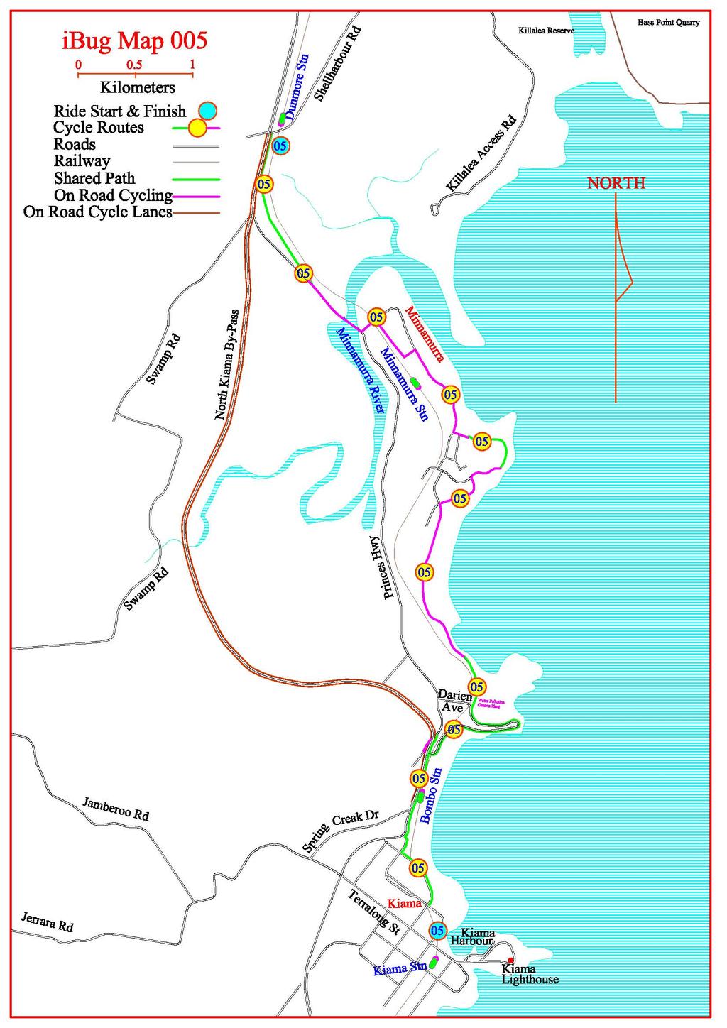
18 Dunmore Station to Kiama Map Reference: ibug Map 005 Start: Dunmore Station Finish: Kaima Grade: Moderate/Easy Distance: 15 Kilometres ibug ride No 005b Ride summary: This is one of the easier rides, while it has some short steep hills it is well worth taking your time to enjoy this ride along some of the best coastal riding in the Illawarra. Cautions! Walk down the steep hill on Cliff Drive if you are not experienced at riding on steep hills The ride starts at Dunmore Railway Station and follows the shared use path south through the Swamp Oak forest between the railway and the old Highway, the wooden bridges over the creeks can be slippery after rain. On exiting the forest follow the marked route across the Minnamurra River, turn left into the first street after crossing the bridge, this leads to a railway underpass, don t ride straight down the stairs, and access to the back streets of Minnamurra. The shared path is immediately on the right after the under path. Follow the path to Rangoon Road and the marked cycle lanes along back roads leading to the shared path around Minnamurra Point from the end of Carson Place. This section provides some excellent coast views with regular whale sightings during the migration periods. Looking over Minnamurra River and Township from John Oates Reserve From the end of the shared path follow the marked route through Kiama Downs, along Boyd s Beach and Cathedral Rocks and on to the shared path around Bombo Headland, the site of some of the earlier Blue Metal Quarrying from the late 1800 s and now the site of the Bombo Sewage Works. Turn left and down the hill to Bombo Beach, there are toilets at the beach, under the railway, under the North Kiama Bypass, turn right and over the railway lines, under the Bypass again and up the hill and turn right to join the shared path along the Bypass Follow the shared path past Bombo Station and over Spring Creak, turning sharply left and steeply down the embankment to join Hothersal Street and on to the Shared path beside Gipps Street over the hill to Kiama. It is well worth the time to explore the many places of interest in Kiama before heading home by retracing you steps, ibug ride 008 or by train (check if the trains are running before leaving Dunmore) after a leisurely lunch. Please help support the locals who support cycling in the Illawarra 27 Collins Street Kiama Phone kiamacycles@gmail.com While in Kiama visit Des and Wendy at Kiama Cycle & Sports for all you re cycling and sporting needs, bicycle accessories, spares, repairs and the latest information on cycling around Kiama. For more Illawarra Cycling information visit the Illawarra Bicycle Users Group at
19

20 The Robo Pie Shop Run ibug ride No 006 Map Reference: ibug Map 006 Start: Albion Park Finish: Albion Park Grade: Extreme Distance: Albion Park to Pie Shop 20 Km, Pie Shop to Jamberoo 26 Km, Jamberoo to Albion Park 10 Km. Illawarra Bicycle Users Group Ride summary: This is a ride for the fit and energetic riders as it involves riding up Macquarie Pass Cautions! Areas of fast moving multi-landed traffic associated with this ride and riders need to ride defensively and carefully at all times. Extreme caution needs to be exercised when riding down the steep hills and narrow roads associated with this ride. From Albion Park ride west along the Illawarra Highway through undulating hills until you reach the bottom of Macquarie Pass. You now begin the steep climb up the winding narrow road to the top. to climb the 600metre climb to the top. After riding up hill for 6 kilometres and gaining 600metre in altitude you finally reach the top and some easier riding to the Pie Shop After a well earned rest and refreshments at the Pie Shop, return to Albion Park by retracing your route or back via Jamberoo. Extreme caution needs to be exercised when riding down the very steep, winding and narrow sections of Macquarie Pass and Jamberoo Mounting Pass If returning back down Macquarie Pass watch for slow moving cars at sharp corners and cars on the wrong side of the road. The foot of Macquarie Pass and an indication of what s ahead To return via Jamberoo turn into Jamberoo Mountain Road opposite the Pie Shop and follow it down the escarpment to Jamberoo road. On reaching the end of Jamberoo Mountain Road turn left onto Jamberoo Road and follows it back to Albion Park or turn right and return to Kiama via Jamberoo township. Albion Park Pie Shop For more Illawarra Cycling information visit the Illawarra Bicycle Users Group at
21

22 Mount Keira Mount Kembla Loop ibug ride No 007 Map Reference: ibug Map 007 Start: Figtree Park next to Westfield Finish: Figtree Park next to Westfield Grade: Hard/Extreme Distance: 24 Kilometres Illawarra Bicycle Users Group Ride summary: This is a ride for the fit and energetic riders as it involves riding up Mount Kembla Cautions! Extreme caution needs to be exercised when riding down the steep hills associated with this ride. From Figtree Park cross the Princess Highway and head north turning left into London Drive, to getaway form the traffic on the Highway. Turn left into Yellagong Street and start climbing. Turn left onto Mount Keira Road, watching for traffic and cars coming out of driveways. The next two kilometres is the steepest section of the climb up Mount Kiera. Once you have left the built-up area the road is less steep but winding, near the top you can turn right into Queen Elizabeth Drive and the short steep climb to the Mount Keira Lookout to enjoy the views and a coffee. About a kilometre past the Elizabeth Drive turnoff turn left into Clive Bissell Road and left into Harry Graham Drive. Follow Harry Graham Drive up nad down several steep hills, turn left into Cordeaux Road, and down hill through Historic Mt Kembla Village. Turn left into Gibson Road and follow it ack the Princes Highway and follow the Highway back to Figtree. Mt Keira MT Kembla For more Illawarra Cycling information visit the Illawarra Bicycle Users Group at
23

24 Kiama to Oak Flats via North Kiama By-pass ibug ride No 008 Map Reference: ibug Map 008 Start: Kiama township Finish: Oak Flats Station Grade: Moderate Distance: 20 Kilometres Ride summary: This ride is a mixture of shared path, cycle lanes and on road cycling Cautions! Watch for fast moving traffic along Shellharbour Road and blind corner when passing under the North Kiama Bypass on Tabbita Road From Kiama Township follow Terralong Street west under the Kiama By-pass turning right into Spring Creek Drive to join the shared path along the Princes Highway (Kiama By-pass) and the cycling lane along the new North Kiama By-pass until you reach the Tabbita Road intersection, turn left off the Highway and cross level crossing to join Shellharbour Road by turning under the Highway. Follow Shellharbour Rd to the first roundabout at the top of the hill, just past the Golf Course. Turn right and follow Shell Cove back streets to rejoin Shellharbour Road at the second roundabout, to avoid the traffic on Shellharbour Road or continue along Shellharbour road to the second roundabout. At the second roundabout, turn West into Lakewood Boulevard, right into Munmorah Circuit, Willinga Road and left into Brunderee Road. At the second roundabout on Brunderee Road turn left into Pioneer Road, over the hill and through the roundabout on New Lake Entrance Road and on to Oak Flats Station To avoid the steep section of Pioneer Road with its poor edges and fast moving traffic and the roundabout at New Lake Entrance Road turn right into College Avenue left into Cygnet Avenue and the shared path through the park to join the shared path along New Lake Entrance Road and on to Oak Flats Station, using the underpass alongside the railway. For more Illawarra Cycling information visit the Illawarra Bicycle Users Group at
25

26 Around the Lake ibug ride No 009 Map Reference: ibug Map 009 Start: Windang Finish: Windang Grade: Moderate Distance: 40 Kilometres Ride summary: This ride has been arranged to utilise back Streets and shared path to avoid the busier main roads where possible, the ride can be varied to suit the ability and preferences of riders. Cautions: There are a number of narrow bridges and areas of fast moving traffic associated with this ride and riders need to ride defensively and carefully in these areas From the Windang Foreshore Park, adjacent to Windang Bridge, ride north along Ocean Street and Boundary Road to join the shared path along Windang Road towards Warrawong. At the intersection of Shellharbour Road and King Street, just after passing the Port Kembla Golf Course, cross the road at the traffic lights to join the shared path on the other side of the road. The Shared path now follows the northern shore of Lake Illawarra around Kully Bay, and past the Illawarra Rowing Club, the Illawarra Yacht Club and Dix s Wharf before reaching the Berkeley Boat Harbour and Fish Co op. making an ideal place to take a break and enjoy some of the local seafood. The shared path continues along the Lake s foreshore through the Budjong Creek Wetlands and Hooka Point, crossing Hooka Creek and into Fred Finch Park. Follow Hooka Creek Road out of Fred Finch Park and left on to the shared path along Northcliff drive. Turn left on to the shared path and left onto the Southern Freeway, leave the Freeway at the Kanahooka Road over pass. Turn right into Kanahooka Road and left into Yalunga Street crossing the Princess Highway at the roundabout and then left into Osborne Street, which becomes Marshall Street and then Larama Avenue before exiting on to the Princess Highway. You can turn up any of the side streets along Osborne Street to get to the business district in Dapto s main street for a quick cup of coffee or a leisurely lunch. Follow the Princess Highway, mostly in on road cycling lanes to Haywards Bay and the end of the cycling lane at Macquarie Rivulet. There is a break in the Armco safety fence just before the bridge which provides access to the path on the eastern side of the bridge and the shared path south of the bridge. The shared path from the southern end of the Macquarie Rivulet Bridge follows Macquarie Rivulet, under the railway and exits onto Shearwater Boulevard, which in turn becomes Koona Street. Follow Koona Street to its end to gain access to Slaters Pedestrian Bridge. After pushing your bike over the bridge turn left into Bridge Avenue, Left again into Deaken Street and left into The Boulevarde which is followed until you reach Central Park. Alternately you can turn right from Koona Street into Wooroo Street, left into Industrial and left into Moore Street and rejoin the loop along The Boulevarde. Turn into the park to access the beginning of the Lakeside shared path which follows southern side of the lake back to Windang Bridge and the end of the ride. For more Illawarra Cycling information visit the Illawarra Bicycle Users Group at
27

28 North Macquarie Loop ibug ride No 010 Map Reference: ibug Map 010 Start: Oak Flats Station Finish: Oak Flats Station Grade: Moderate Distance: 33 Kilometres Illawarra Bicycle Users Group Ride summary: This is an on road ride and involves sections on busy roads. The ride starts and finishes at Oak Flats Station, the ride overlaps other loops in places and you could arrange sections of different rides to make a loop to suit your preferences or shorten the loop if the weather changes and you need a quick retreat Cautions: There are a number of narrow bridges and areas of fast moving multi-lane traffic associated with this ride and riders need to ride defensively and carefully at all times From the southern end of Oak Flats Station car park follow the shared path under New Lake Entrance Road to join New Lake Entrance Road at its intersection with Pioneer Road, turn left onto New Lake Entrance Road and follow the signs to Albion Park and the East West Link Road. A section of the East West Link has cycling lanes along it. Looking west from the cycling lane on the East West Link Road with the Illawarra escarpment in the background After a few kilometres the East West Link Road turns left onto Croom Road and then right into Ashburton Drive. Cross Terry Street (5Km) and continue along Ashburton Drive to Daintree Drive. Turn right into Daintree Drive, left into Hillside and left into Church Street. Church Street will bring you to The Illawarra Highway (9 Km), turn left onto it and follow it towards Macquarie Pass until you reach North Macquarie Road on your right (12 Km). Turn into North Macquarie Road, there is a causeway soon after turning onto North Macquarie Road and care must be exercised as the causeway fluffs during wet weather Follow North Macquarie Road through farming country turning left into Calderwood Road (16 Km) and right into Marshall Mount Road (18.5 Km) which is followed to its end at Huntley Road passing Yallah Road on route. From the end of Marshall Mount Road (24.5 Km) turn right into Huntley Road and right onto the Princess Highway which is followed to the traffic lights at Albion Park Rail. Turn left into Creamery Road, over the railway lines and right into Burroo Street. Burroo Street turns into Wooroo Street. From Wooroo Street turn right into Industrial Road and follow it back to Oak Flats Station For more Illawarra Cycling information visit the Illawarra Bicycle Users Group at
29

30 Wollongong to Thirroul and the end of the cycleway ibug ride No 011 Map Reference: ibug Map 011 Start: Belmore Basin (Wollongong Harbour) Finish: Thirroul Beach Reserve Grade: Easy Distance: 17 Kilometres Ride summary: This ride is predominately on shared path with some short sections on back streets. Caution: Watch for people on the shared path especially around surf clubs and cafes. The ride starts at Belmore Basin, also known as Wollongong Harbour, and follows the cycleway north to its end at Thirroul. This route is possibly the most used, and the most scenic, section of the shared path in the Illawarra. Follow the shared path north along the disused 1800 s rail cutting, past North Wollongong Surf Club, keeping to the left side of the path and watching for pedestrians crossing the path. After passing North Wollongong Surf Club the path turns left and crosses Cliff Road into Stuart Park. The path exits Stuart Park, crosses Para Creek and follows Squires Way until it intersects with Elliotts Road. Turn right at Elliotts Road, follow it to Fairy Meadow Beach and turn left onto the shared path to Towradgi. Watch for other cyclists and pedestrians at the narrow section on the path at the under path. From Towradgi, the shared path follows the coastline passing by Corrimal, Bellambi and Woonona Beaches. Just past Woonona Surf Club the path crosses Kurraba Road and continues north to Bulli Beach, Sandon Point Beach, Sandon Point and finishes at Hamilton Road Thirroul. You can extend this ride further by riding up the hill on Hamilton Road, turning right into Tasman Craig Street, right into Cliff Parade and on to Thirroul Beach Reserve. Toilets can be found at Towradgi Point, Bulli Beach Reserve and at Thirroul Beach Reserve. Coffee shops: Blue Moon Marine Parade Towradgi, One on Park Park Road Woonona, Ruby s Bulli Beach Reserve East Corrimal Caravan Park and at Thirroul Beach Reserve. For more Illawarra Cycling information visit the Illawarra Bicycle Users Group at
31
32 Around the Lake On The Road ibug ride No 012 Map Reference: ibug Map 012 Start: Palican Park off Reddall Parade Mt Warrigal Finish: Palican Park off Reddall Parade Mt Warrigal Grade: Hard to Extreme Distance: 40 to 60 Kilometres Ride summary: This ride is an on road ride and involves sections on multi-lane roads. The distance and difficulty is dependant on the route selected as there are many opportunities to increase the level of difficulty and is suited to fit road wise riders. Cautions: There are a number of narrow bridges and areas of fast moving multi-landed traffic associated with this ride and riders need to ride defensively and carefully at all times Assemble in Pelican View Reserve off Reddall Parade Lake Illawarra, just south west of Windang Bridge, and use the shared path to access Shellharbour Road and over Windang Bridge. Follow Windang Road, and King Street to Warrawong. Turn left into Northcliffe Drive and follow Northcliffe Drive to Berkeley, turn right into George Street opposite Berkeley boat Harbour. George Street becomes Berkeley Road after the first roundabout. At the second roundabout at the intersection with Semaphore Road you can continue along Berkeley road over the hill and past the Nan Tien Temple. Berkeley Road turns left just past the Temple entrance and crosses over the F6 Southern Freeway, turn left into Investigator Drive and Right into Nolan Street, or for a real workout for the legs, take the steeper option of turning left into Semaphore Road and up over the hill past the water tank and turn right into Nolan Street to rejoin the ride. After crossing the Railway lines turn left onto the Princes Highway, continue along the highway turning right into West Dapto road opposite Kembla Grange Racecourse. Turn left into Shone Avenue after a few kilometres and the left again into Bong Bong Road to Dapto. Cross the Railway lines and turn right into Marshall Street and follow until you reach Avondale Road where you can either turn left if the legs are feeling tiered and take the short option back to the start or if the legs are willing take the longer hilly ride. The Short Way Home. Turn left into Avondale Road then right onto the Princess Highway which is followed to the traffic lights at the intersection with Creamery Road Albion Park Rail. Turn left into Creamery Road, over the railway lines and right into Burroo Street. Burroo Street turns into Wooroo Street. From Wooroo Street turn right into Industrial Road and left into Moore Street and through the roundabout into The Boulevard. The Boulevard soon becomes The Esplanade and then Reddall Parade which is followed back to Pelican Park and the end of the ride. The Long Way Home. Turn right into Avondale Road, left into Huntley Road, right into Huntly Road, right into Marshall Mount Road and left into Calderwood Road. On reaching Albion Park turn left into Taylor Road, right onto the Illawarra Highway and straight through the traffic lights to join Terry Street. From Terry Street turn left into Ashburton Drive and onto The East West Link, at the roundabout, over the Princess Highway, follow the Warilla signs. On reaching the next roundabout turn right into Pioneer Drive and up the hill. Turn left into Brunderee Road and right into Wattle Road. Turn left from Wattle Road onto Shellharbour Road and follow it back to Pelican Park and the end of the ride. For more Illawarra Cycling information visit the Illawarra Bicycle Users Group at
33

34 Calderwood Loop ibug ride No 013 Map Reference: ibug Map 013 Start: Albion Park Station Finish: Albion Park Station Grade: Moderate Distance: 16 Kilometres Illawarra Bicycle Users Group Ride summary: This ride is an on road ride through the west of Albion Park hills. Cautions: There are a number of narrow bridges and areas of fast moving multi-lane traffic associated with this ride and riders need to ride defensively and carefully at all times From the Albion Park Station car park cross the Princes Highway into Station Street, turn right into Tongarra Road and cycle to Albion Park. Turn right into Calderwood Road (3 Km) after passing though the centre of town. Turn right from Calderwood Road into Marshall Mount Road (7.3 Km) and follow this to Yallah Road (11.2 Km), turn right into Yallah Road and follow it to the Princess Highway Overpass at Haywards Bay. Using the Haywards Bay Overpass access the south bound cycling lane on the Princess Highway, noting that the cycle lane stops abruptly before the Macquarie Rivulet Bridge and you will need to use the road lane to cross the bridge. Follow the Princes Highway to Albion Park Rail the station is just past south of the shopping centre. For more Illawarra Cycling information visit the Illawarra Bicycle Users Group at
35

36 Shellharbour, Jamberoo Loop ibug ride No 014 Map Reference: ibug Map 014 Start: Shellharbour Boat Harbour Finish: Shellharbour Boat Harbour Grade: Hard Distance: 45 Kilometres Illawarra Bicycle Users Group Ride summary: This ride is an on road ride Passing through Kiama, Jamberoo and Oak Flats, the ride involve sections on multi-lane roads, fast traffic and numerous hills. Cautions: There are a number of narrow bridges and areas of fast moving multi-lane traffic associated with this ride and riders need to ride defensively and carefully at all times From the Park on the shore of Shellharbour Boat Harbour follow Addison Street through Shellharbour Village and turn left onto Shellharbour Road. At Dunmore cross the railway and turn left onto the Princess Highway. Stay on the Princess Highway past Kiama Downs until you reach the shared path near Bombo Station, this is a pleasant ride now the North Kiama By-pass is in use and the number of cars has been reduced. Alternately you can use the cycle lane on the North Kiama By-pass to reach Bombo station Looking down the old highway towards Kiama before joining the Shared Path to Bombo Follow the shared path until its end and rejoin the Highway turning left into Gipps Street and immediately right into Brown Street and the steep climb to Terralong Street. Turn right into Terralong Street and follow it under the Princess Highway to join Jamberoo Road, which is followed to Jamberoo. From Jamberoo continue along Jamberoo Road through more hilly terrain towards Albion Park, the road changes name to Terry Street before reaching Albion Park. On reaching Terry Street s intersection with Ashburton Drive you can turn left and follow the North Macquarie ride to extend the ride (see ibug Ride010), or turn right into Ashburton Drive and follow it and The East West Link road back to Oak Flats. If you have taken the long option continue past Oak Flats station to rejoin the ride at the New Lake Entrance Road roundabout. On reaching the roundabout over the Princess Highway join New Lake Entrance Road turning right into Pioneer Drive, at the next roundabout, and the next hill. Turn left into Bruderee Road and right onto Wattle Road to join Addison Street back to Shellharbour Boat Harbour For more Illawarra Cycling information visit the Illawarra Bicycle Users Group at
37

38 Albion Park Jamberoo Loop ibug ride No 015 Map Reference: ibug Map 015 Start: Albion Park Finish: Albiom Park Grade: Hard Distance: 35 Kilometres Illawarra Bicycle Users Group Ride summary: This ride is an on road ride and involves sections on multi-lane roads, fast traffic and numerous hills and while described as loop it is mostly used as an extension to other rides such as the Around the Lake on the Road (see ibug ride 012) Cautions: There are a number of narrow bridges and areas of fast moving multi-lane traffic associated with this ride and riders need to ride defensively and carefully at all times From the Albion Park follow Terry Street and Jamberoo Road south to Jamberoo Village, passing through principally farming country on narrow winding hilly roads. From Jamberoo continue following Jamberoo Road turning left into Swamp Road until you reach the North Kiama By-pass. Turn left onto the cycling lane on the North Kiama Bypass and exit it at the Tabbita Road exit to join Shellharbour road at Dunmore. Follow Shellharbour Road to its intersection with Wattle Street, turn left into Wattle Street and follow it up the hill turning left into Brunderee Road. From Brunderee Road turn right into Pioneer Road and follow it to the roundabout on New Lake Entrance road. Turn left into New Lake Entrance Road and follow it over the Princess Highway and onto The East West Link Road. Follow the Link Road left at the roundabout at the intersection of Croome Road. The Link Road becomes Ashburton Drive and at the intersection of Terry Street turn right to return to the start at Albion Park. Swamp Road heading towards North Kiama Bypass For more Illawarra Cycling information visit the Illawarra Bicycle Users Group at
39

40 Thirroul to Stanwell Park and Bald Hill ibug ride No 016 Map Reference: ibug Map 016 Start: Thirroul Finish: Stanwell Park Grade: Hard Distance: 17 Kilometres Illawarra Bicycle Users Group Ride summary: The ride follows the coast north from Thirroul along Lawrence Hargrave Drive. The is a road ride and involves sections on multi-lane roads, fast traffic and numerous hills. Unless you continuing on north you will need to retrace the ride home or catch the train, remembering to check that the trains are running as busses used to replace trains during trackwork don t accept bicycles. Cautions: Areas of fast moving multi-landed traffic associated with this ride and riders need to ride defensively and carefully at all times From the end of the shared path at Thirroul follow Hamilton Road, turning right into Tasman Crescent, left into Craig Street, right into Surfers Parade, left into Cliff Parade and onto The Esplanade to get to Lawrence Hargrave Drive. Alternately you can start from Thirroul Station if you intend to return by train. From here the ride is simply a matter of following Lawrence Hargrave Drive north through Austinmer, Coledale, Wombarra, Clifton, then over the Sea Cliff Bridge to Coalcliff and Stanwell Park. On reaching Stanwell Park you can relax over a Coffee or take the steep ride up Bald Hill to admire the views over the coast. To give the legs some additional work you can detour up Asquith Street Austinmer and follow Buttenshaw Drive and Morrison Avenue to rejoin Lawrence Hargrave Drive at Wombarra. The descent down Morrison Avenue is extremely steep and care should be taken at this point. Cyclist enjoining the views from Bald Hill on the MS Sydney to Gong Ride, before heading back to Southerland as the Seacliff Bridge was still under construction. For more Illawarra Cycling information visit the Illawarra Bicycle Users Group at
41

42 Stanwell Park or Bald Hill to Bundeena and Cronulla ibug ride No 017 Map Reference: ibug Map 017 Start: Stanwell Park Finish: Bundeena and Cronulla Grade: Hard Distance: 32 Kilometres Illawarra Bicycle Users Group Ride summary: The ride follows the coast north from Stanwell Park to Bundeena and the ferry to Cronulla. Cautions: The ride involves several long steep hills on narrow roads with poor edges and is suitable for experienced road riders only. This ride is also a favourite ride for motorcyclists and people need to remain on the correct side of the road and watch for motorcyclists on Lady Wakehurst Drive. Take plenty of food and water as there are no services on this ride From Stanwell Park follow Laurance Hargrave Drive north turning right into Lady Wakehurst Drive and the steep climb up to Bald Hill, the road climbs some 110 meters in less then one and a half kilometres. Looking South from Laurance Hargrave Memorial Lookout After a well earned rest at the Laurance Hargrave memorial, at the top of Balled Hill to take in the spectacular coastal views in both directions, continue up more easily to the top of Otford Lookout. From Otford Lookout the road is downhill into the Royal National Park. After passing the Park entrance and following the Hacking River down stream for some kilometres, at approximately 14 kilometres, where McKell Avenue crosses the river on the left for the long uphill ride to Waterfall, Lady Wakehurst Drive changes its name to Sir Bertram Stevens Drive. Continue straight ahead into Sir Bertram Stevens Drive and follow it through undulating country to the Garie Beach turnoff. Continue along Sir Bertram Stevens Drive for a further 5.5 kilometres, pasing the Wattamolla turnoff, and turn right into Bundeena Drive, this section is predominately down hill loosing 150 meters over the final 9 Kilometres to Bundeena. From Bundeena its best to catch the ferry to Cronulla and the train home alternately you could retrace you steps back to the beginning. For information on the Bundeena to Cronulla ferry contact Cronulla and National Park Ferry Cruises on or visit them on Side trips: Garie Beach is a two kilometre winding downhill ride loosing some 200 meters which needs to be regained on the return trip back to the turnoff. Wattamolla three kilometre downhill ride loosing some 150 meters which needs to be regained on the return trip back to the turnoff. Wattamolla has some excellent swimming and surfing opportunities Many of the fire trails are open to cyclists; please check with NSWNP for further details, as conditions change and some trails may be closed at times. The trails are not maintained and are not suitable for road bikes. Copies of the Otford and Port Hacking 1:2500 Topographic Maps and a campus should be carried if venturing onto the fire trails. For more Illawarra Cycling information visit the Illawarra Bicycle Users Group at
43


44 Commuting around the University of Wollongong Map Reference: ibug Map 018 Start: Various Finish: University of Wollongong Grade: Moderate Distance: ## Kilometres ibug ride No 018c Illawarra Bicycle Users Group Ride summary: The University commuting guide can also be used by cyclists accessing the Botanic Gardens, Glennifer Brae and Beaton Park. Cautions: Areas of fast moving traffic along the northern Distributor and other on road sections. Low headroom in the Smith Street Railway Underpass. Travelling from the North along the Northern Distributor Leave the Northern Distributor cycling lane at the off ramp leading to the cycleway along University Avenue and follow the signs erected by council to the Southern Freeway Overpass. For the return journey it is more pleasant and safer to head north along the path between the Southern Freeway and Wollongong TAFE, from the overpass, exiting onto Lysaght Street. Follow Lysaght Street to its intersection with the Princess Highway, cross the Highway and join the cycling lane heading north on the Northern Distributor Southern Freeway Overpass Commuting from Balgownie, Fernhill or the Fairy Meadow area The Shared path around Wollongong TAFE from Mount Ousley Road and Helen Gaynor Avenue or Lysaght Street and use the Southern Freeway Overpass to access Wollongong University Commuting between Campus East, North Wollongong Station, Towradgi or the Coastal Shared Path and the University Pickup the shared path at the intersection of Squires Way and Elliotts Road and follow it through the University of Wollongong Campus East (see map 18) and turn left onto the cycling lane along Montague Street and cross the Princess Highway (Flinders Street) at the traffic lights use the footpath to gain access to Station Street. Follow Station Street to North Wollongong Station and use the lifts to cross the railway lines. Follow the cycling lane along Porter Street and University Avenue, carefully cross at the roundabout to join the shared path to the Southern Freeway Overpass to access the University of Wollongong. The section from the station to the Overpass has been signposted by Wollongong council LOW CLEARANCE CYCLISTS DISMOUNT Cycle Underpass at the west end of Smith Street Central Wollongong to the University From the top end of Crown Street near Wollongong Station use Railway Parade and Belmore Street to get the western end of Smith Street and the Railway Underpass. From the eastern side of the city and the Entertainment Centre use back streets to get onto Smith Street and head west to the Railway Underpass. Watch your head when using the Underpass. On leaving the Underpass follow the shared path under Throsby Drive and along the railway to Beaton Park, watch for cyclist joining the path from Throsby Drive on your right. Follow the sign posted route past the end of Gipp Street, Crawford Avenue and left onto the cycling lane along Porter Street. Follow the cycling lane along Porter Street and University Avenue, carefully cross at the roundabout to join the shared path to the Southern Freeway Overpass to access Wollongong University. Using Denison Street to join the shared path west of the Smith Street Underpass may be the easiest way for people commuting form the around the Hospital, West Wollongong, Coniston and Gladstone Avenue. Figtree, Mt St Tomas and Coniston Use a combination of cycle shoulder lanes and on road cycling along the Avenue and Gladstone Av to reach Wollongong station and then follow the above Central Wollongong to Uni description. For more Illawarra Cycling information visit the Illawarra Bicycle Users Group at
45


.")

46 Gerringong to Kiama via Kiama walking track ibug ride No 019 Map Reference: ibug Map 019 Start: Gerringong Railway Station Finish: Kiama Harbour Grade: Moderate (involves some walking) Distance: Approximately 14 Kilometres Ride summary: The coastal track is suited to mountain bikes in dry weather only as it is a natural track. The Kiama Coast Walk takes a dramatic, coast-hugging route between Werri Lagoon and Loves Bay and when linked with the surrounding shared use path and backstreets provides an exhilarating day out from Gerringong Railway Station to Kiama. While there is no formed track and cyclists need walk across beach heads and exercise caution near cliff edges, the path makes a pleasant change form cycling along the Princess Highway with its fast moving traffic and poor edges. Cautions! This is a dry weather ride only! The track can be slippery and access across Werri Lagoon may not be possible after heavy rain. The track provides access to the rugged coastline with its rock pools and rock platforms which can be dangerous with unexpected waves braking over the platforms. The ride starts at Gerringong Railway Station (please check if trains are running as busses used during times of track work may not take bicycles). From Belinda Street and turning left into Fern Street leads you to Gerringong Township and the last spot for refreshments is the Werri Beach Fish Shop & Café on Pacific Avenue, noting there is no drinking water on the path. Turn right from Fern Street into Sandy Wha Road and left onto the shared use path along Pacific Avenue. From the end of the shared use path, at Lloyd Rees Reserve, cyclists need to walk over the sand to gain the Kiama Coast Walk. Ride the coastal walking track for the next 6 kilometres, ensuring you give way to pedestrians on the path Visit us at Kiama Blow Hole or our website for further information about the walking track and other tourism opportunities in Kiama Photo looking south from the beginning of the coastal walk across Werri Lagoon and the sand spit separating it form the Pacific Ocean. The beach needs to be crossed to gain access to the walking track On reaching the end of the track, at Loves Bay, ride up the pumping station access road to Elanora Road. Follow Elanora Road and turn left into Kalang Road, left into Anembo Crescent. Turn left onto the cycleway along South Kiama Drive, turning right into Marks Street and left into Reid Street and then right onto the shared use path through the park. The shared use path now continues to Terralong Street passing Kendalls Beach, Surf Beach and the Kiama Showground for a range of refreshments, specialty shops and a short ride to Kiama Station For more Illawarra Cycling information visit the Illawarra Bicycle Users Group at:
The Illawarra Bicycle Users Group s Guide to cycling in the Illawarra
 The Illawarra Bicycle Users Group s Guide to cycling in the Illawarra Compiled by Werner Steyer First edition September 2006 6th revision September 2016 Copyright Notice: W. Steyer 2010 You are welcome
Albion Park and Kiama District
 Description of routes in this timetable Albion Park and Kiama District Route 71 Shellharbour to Kiama via Dunmore, Minnamurra, Kiama Downs and Bombo. Service operates Monday to Saturday. Bus Timetable
Illawarra Escarpment State Conservation Area Walking Tracks
 Illawarra Escarpment State Conservation Area Walking Tracks NPWS Illawarra Area Office Ground Floor, Government Office Block 84 Crown Street Wollongong NSW 2500 02 4223 3000 (Mon-Fri) Royal National Park
SCO. South Coast Line. How to use this timetable. Real-time planning. Explanation of definitions and symbols. Accessible services.
 South Coast Line How to use this timetable This timetable provides a snap shot of service information in 24-hour time (e.g. 5am = 05:00, 5pm = 17:00). Information contained in this timetable is subject
Shellharbour District
 Description of routes in this timetable Shellharbour District Route 51 Wollongong to Shellharbour via Warrawong, Primbee, Windang and Warilla. Selected journeys extend to Oaks Flat Station. Service operates
Maximise your marketing and local market profile!
 Maximise your marketing and local market profile! media kit Retail MEDIA KIT Reach your target audience The Illawarra realestateworld.com.au property magazine is the leading real estate only publication
Great Ocean Road Two Day Tour
 www.greatoceanroad.vc Great Ocean Road Two Day Tour This two day trip of approximately 530 kilometre starts from Melbourne and provides a good overview of features along the Great Ocean Road between Anglesea
Split Point Lighthouse Aires Inlet
 www.greatoceanroad.vc Great Ocean Road Three Day Tour 2 Night Stay This three day trip of approximately 730 kilometre starts from Melbourne and provides a good overview of features along the Great Ocean
Victoria Falls Lookout to Blue Gum Forest
 Victoria Falls Lookout to Blue Gum Forest 8 hrs Experienced only 13.8 km One way 5 112m This long day-walk follows a remote track down from Victoria Falls lookout, passing the waterfall, and into the Grose
QUALIFIED CONCRETE CONTRACTORS
 QUALIFIED CONCRETE CONTRACTORS Below is a list of contractors as at 22 January 2013 who are permitted by this Council to do concreting work on Council footpaths within the City of Wollongong. Council does
Maximise your property marketing and local market profile!
 realtor NEW A4 look See inside First Issue 23 August 2018 Real Estate Media Kit Maximise your property marketing and local market profile! The Realtor publication is more than a catalogue of properties.
Maximise your property marketing and local market profile!
 Maximise your property marketing and local market profile! media kit Reach your target audience The Illawarra realestateworld.com.au property magazine is the leading real estate only publication in the
Maximise your property marketing and local market profile!
 Real Estate Media Kit Maximise your property marketing and local market profile! The Realtor publication is more than a catalogue of properties. It is a resource to buyers, sellers and to investors. The
NSW TRAIN LINK: NEW SOUTH WELSH INTERURBAN TRAINS
 NSW TRAIN LINK: NEW SOUTH WELSH INTERURBAN TRAINS NI1 NEWCASTLE - MAITLAND - TELARAH Jl14 SG. Diesel Multiple Units. Electrified for EMUs Newcastle-Hamilton. Double track Newcastle-Waratah, Quadruple Waratah-Maitland,
Mt Kuring-gai Track to Berowra station
 Mt Kuring-gai Track to Berowra station 4 hrs 15 mins 9.7 km One way Hard track 4 553m This walk explores three valleys, with great displays of wild flowers in spring, and some nice sandstone overhangs.
Victoria Falls and Grose Valley to Blackheath Station
 This walk explores a fantastic section of the Grose Valley. Starting above Victoria Falls, the walk explores the cascades before dropping into the valley for the first nights rest at Burra Korain campsite.
Leura Cascades to Gordon Falls Reserve
 Leura Cascades to Gordon Falls Reserve 1 hr 15 mins 1.8 km One way Moderate track 200m From Leura Park to Gordon Falls Park, this diverse walk offers fantastic views of the Jamison Valley, as well as two
Merritts Traverse. 1928m
 Merritts Traverse 3 hrs Hard track 5.8 km Circuit 4 167m This walk starts with a scenic journey to the top of the hill on the chairlift. Starting along Merritts Nature walk, this walk soon detours down
welcome to WOLLONGONG 2014 visitor MINI guide visitwollongong.com.au
 welcome to WOLLONGONG 2014 visitor MINI guide visitwollongong.com.au *the essentials Wollongong essentials: everything you need to know at a glance! Population Approximately 290,000 (Wollongong Statistical
Girrakool to Wondabyne station
 Girrakool to Wondabyne station 4 hrs Hard track 9.5 km One way 4 438m This walk starts from the Girrakool picnic area and winds south, through the Brisbane Waters National Park. The walk crosses some long
Staples Lookout to Mt Wondabyne loop
 Staples Lookout to Mt Wondabyne loop 4 hrs 3 mins 1.8 km Circuit Hard track 337m This walk starts and finishes at Staples Lookout, on Woy Woy Rd. The walk follows sections of the Great North Walk around
DAY 1: Circular Quay to Greenwich Wharf
 DAY 1: Circular Quay to Greenwich Wharf Total Distance: 14km Time: Approximately 5 hours Walk Notes in Six Sections Section Name Length Time 1:1 Circular Quay to Milsons Point Station 2.5km 50mins 1:2
Berowra Waters to Cowan Station
 Berowra Waters to Cowan Station 3 hrs 30 mins 7.2 km One way Hard track 597m This is a hilly walk out of the beautiful Berowra Waters valley to Cowan Station. There are many wide views across Berowra Creek
Bonaqua Mountain Hardware Action Sprint 2013 Discovery Bay,Lantau The Course Route
 Bonaqua Mountain Hardware Action Sprint 2013 Discovery Bay,Lantau The Course Route The start is inside the Discovery Bay plaza and leads out to the main sandy beach where you will run to the end of the
Nature Track. 900m. 789m. 2 hrs 3.1 km Circuit. Hard track 238m. Blue Mountains National Park
 Nature Track 2 hrs 3.1 km Circuit Hard track 238m Largely following the ridges around the top edge of Wentworth Falls, this track is incredibly beautiful. After taking in the great views at Edinburgh Castle
DAY 3: Huntleys Point Wharf to Balmain East Wharf
 DAY 3: Huntleys Point Wharf to Balmain East Wharf Total Distance: 14.5km Time: Approximately 5 hours Walk Notes in Five Sections Section Name Length Time 3:1 Huntleys Point Wharf to Iron Cove Bridge 4km
Congewai Track Head (East) to Watagan Headquarters
 to Watagan Headquarters") Congewai Track Head (East) to Watagan Headquarters 7 hrs Hard track 17.2 km One way 4 973m This full day walk starts from the Congewai valley trackhead (east) and follows the Great North Walk up into the
Congewai Track Head (East) to Watagan Headquarters 7 hrs Hard track 17.2 km One way 4 973m This full day walk starts from the Congewai valley trackhead (east) and follows the Great North Walk up into the
IEEE/ASME International Conference on Advanced Intelligent Mechatronics (AIM) July 2013, Wollongong, Australia
 July 2013, Wollongong, Australia") IEEE/ASME International Conference on Advanced Intelligent Mechatronics (AIM) July 2013, Wollongong, Australia Gursel ALICI (AIM 2013 General Chair) School of Mechanical, Materials, and Mechatronic Engineering
IEEE/ASME International Conference on Advanced Intelligent Mechatronics (AIM) July 2013, Wollongong, Australia Gursel ALICI (AIM 2013 General Chair) School of Mechanical, Materials, and Mechatronic Engineering
Retail Media Kit. realtor NEW A4 look. See inside. Advertise in the Realtor publication, so your product & service is top of mind with consumers!
 realtor NEW A4 look See inside First Issue 23 August 2018 Retail Media Kit Advertise in Realtor publication, so your product & service is top of mind consumers! Reach your target audience Realtor publication
GOLDEN EARS PROVINCIAL PARK
 GOLDEN EARS PROVINCIAL PARK Trail Information as of October 10 th 2015 Do not underestimate the mountainous wilderness of Golden Ears Provincial Park. The combination of rugged terrain and rapidly changing
Britain s oldest surviving water-balanced cliff lift
 44 3.6 Saltburn by the Sea to Sandsend Map panels 3 and 4 Distance 17 miles (27½ km) Terrain mostly grass and field paths which can be muddy; some pavement, beach and shore Grade undulating route, with
National Pass. 893m. 665m. 3 hrs 30 mins 4.6 km Circuit. Hard track 773m. Blue Mountains National Park
 National Pass 3 hrs 3 mins 4.6 km Circuit Hard track 773m 4 This walk offers fantastic views of the Jamison Valley and the surrounding cliffs. Take time to explore the historic and very scenic ledge halfway
Wentworth Pass. 893m. 535m. 4 hrs. Hard track 5.1 km Circuit. 692m
 Wentworth Pass 4 hrs Hard track 5.1 km Circuit 4 692m This walk offers a great way to explore the magical, upper section of the Valley of the Waters. The walk starts and finishes at Conservation Hut, which
Berowra to Cowan via Berowra Waters
 Berowra to Cowan via Berowra Waters 6 hrs Hard track 12.9 km One way 4 884m With train station at each end this walk explores the ridges and valleys around Berowra Waters. There are plenty of excellent
Countryside Trails Dunkeld
 R A N G E R S E RV I C E Countryside Trails Dunkeld WELCOME Welcome to this southern end of Atholl Estates. The countryside here is a wonderful blend of lochs, woodland and heather moor. There is a large
FILLED WITH FACTS & ACTIVITIES. e s. t o. e f. f l BE SAFE, STAY ALIVE!
 FILLED WITH FACTS & ACTIVITIES A an f l us ef e s r u ul guide to kee ping yo n the roa d. o e f a ers s h t o d BE SAFE, STAY ALIVE! Safe Walking The Green Cross Code Crossing Safely Road Signs & Signals
Telluride-to-Moab Alternative Singletrack Options
 Telluride-to-Moab Alternative Singletrack Options Day 1 Day 1 Alternate 1: Galloping Goose to Deep Creek. 18.4 miles, ascent 3,530ft, descent 1,388ft. This is fun, flowey, moderate to intermediate singletrack
Beautiful Walks from the Blue Ball Inn
 Walk No. 5 RIVER VALLEYS AND MOOR Countisbury, Watersmeet, Hillsford Bridge, Cheriton, Shilstone Hill, Rockford and Chiselcombe. 8.5 MILES APPROX. Walking time four and a half hours approx. OS 1;25,000
Centurion Way Chichester
 Centurion Way Chichester Work book of plans to show details of the Centurion Way, its links, and potential developments and enhancements from linking to the South Downs National Park all the way to the
The Queen Stage. 100, 200 & 300 Audax Rides - Saturday 22 nd July 2017
 The Queen Stage 100, 200 & 300 Audax Rides - Saturday 22 nd July 2017 A challenging course including most of the big climbs through Northern Sydney before heading north towards Yarramalong and returning
Blackheath to Blue Gum loop
 Blackheath to Blue Gum loop 2 Days Hard track 24.1 km Circuit 4 1335m This walk is great for fit people getting into overnight walking, with its fantastic scenery and nostalgia as a classic overnighter.
Scenic Railway to Ruined Castle
 Scenic Railway to Ruined Castle 7 hrs 30 mins 12.4 km Return Hard track 4 963m This is a very popular, full day walk, in the Katoomba Area, offering great views of the valley. The walk follows the edge
Coast Path Survey Stretch 09 Shalfleet Mill to Thorness Bay
 Coast Path Survey Stretch 09 Shalfleet Mill to Thorness Bay Overview Map of stretch Introduction This stretch of Island coast covers several salt marsh creeks backed by grazing land and woodland on the
HARDMOORS ROUTE DESCRIPTION
 HARDMOORS 60 2016 ROUTE DESCRIPTION RACE START (GUISBOROUGH) - CHECKPOINT 2 (SALTBURN) DISTANCE 9 MILES CUT OFF TIME 1030 GRID REF OS 666 208 1. Leaving the Sea Cadets Hall, turn left onto the road and
South East Traffic Solution
 South East Traffic Solution A MAJORITY LIBERAL GOVERNMENT WILL: Complete the Hobart Airport Interchange project Fix the Tasman Highway near Tasmania Golf Club Replace the Midway Point Roundabout with additional
Baggy Point, Croyde, North Devon
 Baggy Point, Croyde, North Devon A walk using the South West Coast Path that is likely to be suitable for people with impaired mobility or with a pushchair, wheelchair, or mobility scooter. The Coast Path
The Mendip Way. Route Directions and Maps Uphill to Wells
 The Mendip Way Route Directions and Maps Uphill to Wells Website: www.mendiphillsaonb.org.uk Email: mendip@mendiphillsaonb.org.uk Facebook & Twitter: @MendipHillsAONB Phone: 01761462338 1 Uphill to Loxton
Road Signs, Markings and Their Meaning
 Road Signs, Markings and Their Meaning FUNCTIONS OF ROAD SIGNS AND MARKINGS 1. Guides 2. Directs 3. Warns 4. Informs 5. Prohibits 6. Regulates CLASSIFICATION OF ROAD SIGNS 1. Warning 2. Regulatory 3. Informatory
At the time, the portion of the line through Eagle County remains wholly under the ownership of Union Pacific Railroad (UP).
.") Chapter 5 The Railroad Corridor as a Trail Corridor The intent of this chapter is to identify how the rail corridor, if available for lease or purchase in all or part, could be incorporated into the core
Chapter 5 The Railroad Corridor as a Trail Corridor The intent of this chapter is to identify how the rail corridor, if available for lease or purchase in all or part, could be incorporated into the core
Wollongong Loop (clockwise) (Route 7/8) Monday to Friday
 (Route 7/8) Monday to Friday") 6 ref Route Number 8 7 8 8 7 8 7 8 7 8 7 A Wollongong Entertainment Centre... 06:55 07:13 07:40 07:50 08:15 08:51 09:15 09:51 10:15 10:51 B Keira Street after Crown Street... 07:00 07:18 07:45 07:55 08:22
6 ref Route Number 8 7 8 8 7 8 7 8 7 8 7 A Wollongong Entertainment Centre... 06:55 07:13 07:40 07:50 08:15 08:51 09:15 09:51 10:15 10:51 B Keira Street after Crown Street... 07:00 07:18 07:45 07:55 08:22
C E N T R A L C A T S K I L L S
 120 C E N T R A L C A T S K I L L S Central Catskills Once out of the southern parts of the Catskills, the Long Path enters the more well traveled and civilized regions. The trail joins the Devil s Path,
Skiing and Snowshoes on Un-groomed Fernan Saddle Terrain
 Skiing and Snowshoes on Un-groomed Fernan Saddle Terrain Three ski or snowshoe routes are available from the Fernan Saddle Parking Lot which either do not cover routes ordinarily groomed for snow machine
Self-Guided Walk Langdale Pikes. Start & Finish: NT car park (free to members) at Sticklebarn - on the right just beyond the New Dungeon Ghyll hotel.
 at Sticklebarn - on the right just beyond the New Dungeon Ghyll hotel.") Self-Guided Walk Langdale Pikes Key Information These mountains form a collection of spires and cliffs on the north side of Langdale. This walk visits four of the main tops Pavey Ark, Harrison Stickle,
Self-Guided Walk Langdale Pikes Key Information These mountains form a collection of spires and cliffs on the north side of Langdale. This walk visits four of the main tops Pavey Ark, Harrison Stickle,
CWMGIEDD FROM ABERCRAVE
 Abercrave to Cwmgiedd Walk Page 1 Starting from The Abercrave Inn. Grid Ref: SN 824128 From the Abercrave Inn, an 11.3km (7 miles) walk to the foothills of the Cribarth Mountain, then through forest to
July. lllawarra Historical Society
 lllawarra Historical Society July 39 TWO TRIPS TO WOLLONGONG IN 1841 AND 1888 A CONTRAST It was about the middle of February, 1841, I first left Sydney for Wollongong to take up my residence in the lllawarra
Difficult Run Stream Valley Park
 Difficult Run Stream Valley Park The more intense mountain bikers have known about for Difficult Run for some time. Equestrians have known it longer. Eight miles of unpaved trail, the Rails to River Trail
Travel Information Sheet Visitors to UoW and Wollongong
 Travel Information Sheet Visitors to UoW and Wollongong Generic Travel and Accommodation for Visitors Travel to and from Wollongong Trains: http://www.cityrail.info/timetables/#landingpoint Train travel
Girrakool to Wondabyne station via Pindar caves
 Girrakool to Wondabyne station via Pindar caves 7 hrs 30 mins 18.1 km One way Experienced only 5 741m This walk starts from the Girrakool picnic area and winds south, following Piles creek into the Brisbane
Appendix 6 Fulbourn Greenway Review
 Appendix 6 Fulbourn Greenway Review Nigel Brigham & Associates A report for 1 Introduction This report is based on fieldwork carried out in 2016 to review the Greenway network around Cambridge as shown
Abbotts Falls Walking Track
 Abbotts Falls Walking Track 3 hrs 7.3 km Circuit Hard track 329m This circuit takes you through both dry and moist forest, using a combination of walking trails and wider tracks. The side trip to the dammed
Guthega to Mt Twynam. 2183m. 1583m. 6 hrs 45 mins 14.8 km Return. Experienced only. 913m
 Guthega to Mt Twynam 6 hrs 45 mins 14.8 km Return Experienced only 5 913m This walk starts from Guthega and makes its way along the Snowy River to the Illawong Lodge, via the Blue Cow Creek flying fox.
Victoria Falls to Blackheath Station
 Victoria Falls to Blackheath Station 2 Days Experienced only 22.2 km One way 5 1561m This is a fantastic overnight walk with a sleep in Acacia Flats camping area. The Grose Valley, with its views of the
THE INVESTIGATOR DATE CLAIMER. Glasshouse Bushwalkers Club Inc. June - July Official Newsletter of the Glasshouse Bushwalkers Club Inc.
 THE INVESTIGATOR Official Newsletter of the Glasshouse Bushwalkers Club Inc. DATE CLAIMER In this issue: 11 JUNE 2017 Trachyte Circuit Walk with cancer survivors 25 JUNE 2017 Caboolture to Wamuran (Caboolture
Stephens State Park Trails
 TRAILS OF ALLAMUCHY MOUNTAIN & STEPHENS STATE PARKS Allamuchy Mountain and Stephens State Parks contain 28 marked trails providing access to diverse landscapes for walking, hiking, biking, bird-watching,
Erskine Creek via Pisgah Rock and Jack Evans
 Erskine Creek via Pisgah Rock and Jack Evans 4 hrs 30 mins 7.1 km Circuit Very experienced only 6 421m This walk visits some great lookouts and explores the lower section of Erskine Creek. Most of the
Northern Beaches Transport Action Plan
 Northern Beaches Transport Action Plan The NSW Government is taking action now to deliver transport improvements for the Northern Beaches, as well as planning for the future growth of the area. $633 million
Otago Central Rail Trail, New Zealand - As told by The Fat Controller AKA Mike Lee
 Otago Central Rail Trail, New Zealand - As told by The Fat Controller AKA Mike Lee In February 2015, while things were very quiet at work, a colleague and I decided that we should visit New Zealand and
Index Index2 Index3 Names Name2 Name3 Title Edition Publisher Year B ORGAN, Michael. Illawarra diary of Lady Jane (ed.)
") Index Index2 Index3 Names Name2 Name3 Title Edition Publisher Year B4.500 22 03 ORGAN, Michael Illawarra diary of Lady Jane 1988 (ed.) Franklin, 10-17 May 1839 Historical Publications, B4.500 22 01 SHAW,
Index Index2 Index3 Names Name2 Name3 Title Edition Publisher Year B4.500 22 03 ORGAN, Michael Illawarra diary of Lady Jane 1988 (ed.) Franklin, 10-17 May 1839 Historical Publications, B4.500 22 01 SHAW,
Location: Height: Access: Distance: Elevation: Season: Difficulty: Lat/Long: Directions:
 Upper Eagle Falls Upper Eagle Falls (~20 ft.) is a short hike up from the roadside at the Eagle Falls picnic area. It is very difficult to get a parking spot here during the day, so it is recommended to
Little Grand Canyon near Pomona, Illinois
 Little Grand Canyon near Pomona, Illinois Below: View of the trail and the terrain created using the Map My Hike app Below: Summary of the hike created using the Map My Hike app Presented by: Jennifer
RIVIERA LINE E X E T E R PAIGNTON
 RIVIERA LINE EXETER PAIGNTON Supported by Introduction The Riviera Line offers great scenic train journeys along the South Devon coast between Exeter and Paignton. The train is an ideal way to enjoy a
Victoria Falls and Grose Valley to Blackheath Station
 Victoria Falls and Grose Valley to Blackheath Station 3 Days Experienced only 22.5 km One way 5 158m This walk explores a fantastic section of the Grose Valley. Starting above Victoria Falls, the walk
Premium Waterfront Land for Sale
 Premium Waterfront Land for Sale An opportunity has arisen for the astute investor to purchase one of the last remaining blocks of absolute waterfront land at Berowra Waters. Lot 3 Coba point features
DAY 1: Emu Plains to Glenbrook Wednesday, January 2, 2019
 DAY 1: Emu Plains to Glenbrook Wednesday, January 2, 2019 Some sun: 34 C / 21 C 3mm Meeting time: 8.00am @ Our Lady of the Way Catholic Church, Emu Plains [15 Troy Street, Emu Plains; altitude: 32m] Mass:
T H E W AT E R F R O N T L A N D
 THE WATERFRONT LAND A place you ll truly love to call home With its vibrant future town centre and world class marina, The Waterfront, Shell Cove offers you an unrivalled lifestyle opportunity. Set amidst
GRINDLEFORD GALLOP 2018
 GRINDLEFORD GALLOP 2018 Route Information The Grindleford Gallop follows a fixed 21 mile route through the lanes and paths of Derbyshire. All competitors must follow this route. An OS map of the area with
SYDNEY TO MELBOURNE:A SELF GUIDED MOTORCYCLE TOUR
 SYDNEY TO MELBOURNE:A SELF GUIDED MOTORCYCLE TOUR E S T A D V I C E - B E S T T O U R S - B E S T B I K E S B E S T A D V I C E - B E S T T O U R S - B E S T B I K E S B Sydney Sydney Capital city of New
MORAY COAST TRAIL - Notes on multi-use access
 MORAY COAST TRAIL - Notes on multi-use access The Moray Coast Trail in the north-east of Scotland is one of Scotland s Great Trails. Approximately 50 miles long, the route links settlements between Findhorn
Access Guide to Peel Castle
 Access Guide to Peel Castle Manx National Heritage recognises that historic properties can present difficulties for people with disabilities. We have prepared an access guides for Peel Castle on St Patrick
Woodland Walk If you enjoyed this walk there are two others available in the same area.
 The Woodland Walk 11-12 kilometres (7-8 miles) 4-5 hours Terrain: some easy hills Can be slippery when wet 5 stiles Unsuitable for a pushchair/wheelchair Uses OS map 197 Parking: Pulborough Station and
GOLD COAST, QUEENSLAND AUSTRALIA
 GOLD COAST, QUEENSLAND AUSTRALIA STUNNING UNITERRUPTED BROADWATER VIEWS Coast Broadwater comprises three 12 storey towers situated on Marine Parade, Labrador, Gold Coast. These iconic luxury apartments
18Day Road Tour Christchurch to Christchurch
 18Day Road Tour Christchurch to Christchurch Route: Christchurch Farlie Lake Tekapo Twizel Wanaka Queenstown - Te Anau Milford Sound - Manapouri Queenstown Wanaka Haast Fox Glacier Franz Josef Hokitika
2018 Port Macquarie Cycling Club Recreational Rides
 2018 Port Macquarie Cycling Club Recreational Rides January King Ck Wauchope Sancrox Loop Ride Sterling Green Café (corner Sovereign Drive & Gillman Way, Sovereign Hills (near Donut)) None Loop 42km (plus
Unlocking our Coastal Heritage Strand 2 - Watermouth Bay, nr Ilfracombe
 Unlocking our Coastal Heritage Strand 2 - Watermouth Bay, nr Ilfracombe In order to provide a safe route for users of the South West Coast Path this project realigned 265m of the A399 coast road to incorporate
Ystwyth and Rheidol Bridleway Routes. Route 2:Llanilar Circular
 Ystwyth and Rheidol Bridleway Routes Route 2:Llanilar Circular Route overview and terrain: A long circle using connecting ridges with fine views to link the Rheidol and Ystwyth river valleys. The route
Wednesday 20 Dec. The Great Christmas Bake off! Decorate your very own Christmas cupcakes and biscuits to take home! Fee range*:$9.
 Starts Here! The Fun Dec/Jan School Holiday Program 7am - 6pm Highlight Event: Jamberoo Monday 18 Dec Tuesday 19 Dec Wednesday 20 Dec Thursday 21 Dec Friday 22 Dec Stufflers Make your very own Christmas
Non-motorized Trail Plan & Proposal. August 8, 2014
 Town of Star Valley Ranch, Wyoming and the Star Valley Ranch Association in partnership with the USDA Forest Service, Bridger-Teton National Forest, Greys River Ranger District Non-motorized Trail Plan
The Prince Henry Cliff Walk
 The Prince Henry Cliff Walk 3 hrs 30 mins 6.8 km One way Moderate track 3 575m Going from Katoomba to Leura, this walk covers the top of the cliff line and most of the major lookouts. With brilliant vistas
Jerusalem Bay Track (Cowan to Brooklyn)
") Jerusalem Bay Track (Cowan to Brooklyn) 5 hrs 30 mins 13.4 km One way Hard track 4 654m This Cowan to Brooklyn Station walk is a popular section of the Great North Walk, with scenery ranging from foreshore
Jerusalem Bay Track (Cowan to Brooklyn) 5 hrs 30 mins 13.4 km One way Hard track 4 654m This Cowan to Brooklyn Station walk is a popular section of the Great North Walk, with scenery ranging from foreshore
Hindhead, Keffolds Copse and Gibbet Hill
 point your feet on a new path, Keffolds Copse and Gibbet Hill Distance: 6 km=4 miles Region: Surrey Author: Schwebefuss Refreshments: Punch Bowl Café moderate walking Date written: 14-apr-2015 Last update:
UMASS CROSS-COUNTRY Trails
 UMASS CROSS-COUNTRY Trails 1) EGG (43 min) (A) From Cage proceed to North Pleasant street (by campus pond). Make left and head toward LGRT and pass School of Education. Pass Puffton Apt complex (on left)
The discovery and Growth of Greater Wollongong (by W. H. Mitchell) (continued from September Bulletin) Now, in 1954, the total distance travelled by
 (continued from September Bulletin) Now, in 1954, the total distance travelled by") The discovery and Growth of Greater Wollongong (by W. H. Mitchell) (continued from September Bulletin) Now, in 1954, the total distance travelled by buses in this City is approximately 2,500,000 miles
The discovery and Growth of Greater Wollongong (by W. H. Mitchell) (continued from September Bulletin) Now, in 1954, the total distance travelled by buses in this City is approximately 2,500,000 miles
Sponsored by. statestreet.com
 /STATESTREETISLANDWALK #ISLANDWALKJSY Sponsored by statestreet.com Important Information If you forget everything else PLEASE remember the following.» Remember to check OUT of every checkpoint» If you
Kitimat. Pacific Inland Coast. Hiking Guide Kitimat, British Columbia, Canada
 Kitimat Pacific Inland Coast Hiking Guide Kitimat, British Columbia, Canada 2010-2011 Sites and Trails Emergency Call 911 Police - Fire - Medical 2 Welcome to Kitimat This information was produced to assist
1. Drive to Lake Cowichan via Highway 18 (which connects to the Trans-Canada Highway just north of Duncan)
") Driving Instructions to the Walbran Valley via Lake Cowichan (updated July 2018) 1. Drive to Lake Cowichan via Highway 18 (which connects to the Trans-Canada Highway just north of Duncan) 2. At the traffic
Driving Instructions to the Walbran Valley via Lake Cowichan (updated July 2018) 1. Drive to Lake Cowichan via Highway 18 (which connects to the Trans-Canada Highway just north of Duncan) 2. At the traffic
BISHOPSTONE CIRCULAR WALK
 BISHOPSTONE CIRCULAR WALK 4½ miles (7¼ km) - allow 2 hours (see maps on final pages) Introduction This walk is within the North Wessex Downs Area of Outstanding Natural Beauty and starts from the small,
TASMANIAN TIGER:A SELF GUIDED MOTORCYCLE TOUR
 TASMANIAN TIGER:A SELF GUIDED MOTORCYCLE TOUR E S T A D V I C E - B E S T T O U R S - B E S T B I K E S B E S T A D V I C E - B E S T T O U R S - B E S T B I K E S B The Bay of Fires The Bay of Fires The
Draft Illawarra Escarpment Mountain Bike Strategy. A joint project between National Parks and Wildlife Service and Wollongong City Council
 Draft Illawarra Escarpment Mountain Bike Strategy A joint project between National Parks and Wildlife Service and Wollongong City Council 2018 State of NSW and Office of Environment and Heritage With the
Asheville & WNC Hikes
 Asheville & WNC Hikes Amazingly, we have 3,000+ miles of free public hiking trails near Asheville, including 1,600 miles in the Pisgah and Nantahala National Forests, 850 miles in Great Smokey Mountains
BURGHCLERE PARISH RIGHTS OF WAY
 BURGHCLERE PARISH RIGHTS OF WAY Full descriptions compiled by Neill & Miggie Bruce All photos Miggie Bruce FP23 on Ridgemoor, looking south, with FP22 crossing by the bush FP1. From C183 Aldern Bridge