2.1 Redevelopment Area
|
|
|
- Arthur Fowler
- 5 years ago
- Views:
Transcription


1 DESIGN PRINCIPLES


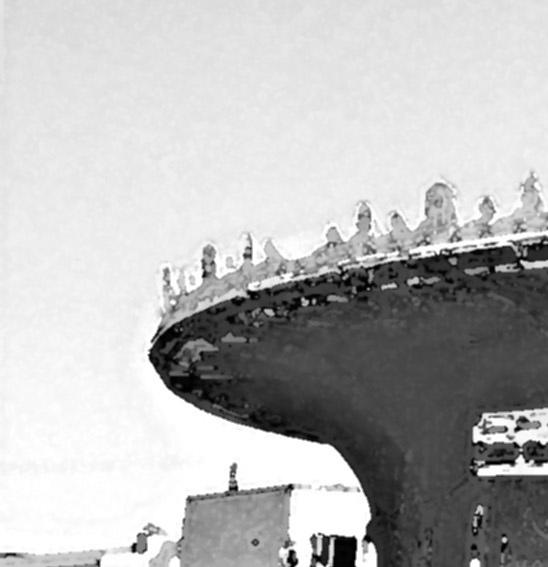
2 7 2.1 Redevelopment Area The Asbury Park Waterfront Redevelopment Area that was designated in November 7, 1984 remains the same area under this plan amendment (see attached map). The land in the redevelopment area includes all of the property between Grand Avenue and the beachfront, consisting of approximately 230 acres. The overall redevelopment area has been divided into three sub-areas, each of which is to receive a somewhat different treatment under this plan. Below is a listing of the three areas and brief characterization of the actions to be taken. VIEW LOOKING NORTH Renovation/Infill Area Area bounded by Grand Avenue in the west; Bergh and Webb Streets in the east; Deal Lake Drive in the north; Asbury and Sewall Avenues in the south Renovation of existing buildings, and infill with new construction where appropriate Property not subject to condemnation Prime Renewal Area Area bounded by Bergh and Webb Streets in the west; Ocean Avenue in the east; stretches along Wesley Lake to Grand Avenue; Deal Lake in the north Most land in this area will be assembled into larger parcels for new construction Property subject to condemnation with certain exceptions VIEW LOOKING SOUTH Boardwalk Area Restoration and/or adaptive reuse of historic structures such as the Casino and Convention Hall Infill of certain sites along the Boardwalk with oceanfront resort type uses Public property subject to negotiated sale to developer
3 8 BOND STREET BOND STREET BANGS AVENUE EMORY STREET EMORY STREET 1984 REDEVELOPMENT AREA BOUNDARY SUNSET AVENUE DEAL LAKE GRAND AVENUE GRAND AVENUE GRAND AVENUE SUMMERFIELD AVENUE MONROE AVENUE SEWALL AVENUE SUNSET LAKE GRAND AVENUE HECK STREET HECK STREET HECK STREET RENOVATION INFILL AREA PARK AVENUE LAKE AVENUE WESLEY LAKE BERGH STREET BERGH STREET ST. JAMES COOKMAN AVENUE ASBURY AVENUE FIRST AVENUE SIXTH AVENUE WEBB STREET EIGHTH AVENUE DEAL LAKE DRIVE KINGSLEY STREET OCEAN AVENUE SECOND AVENUE KINGSLEY STREET THIRD AVENUE KINGSLEY STREET PRIME RENEWAL AREA SUNSET AVENUE FIFTH AVENUE FOURTH AVENUE OCEAN AVENUE SEVENTH AVENUE BOARDWALK BOARDWALK BOARDWALK AREA BOARDWALK ATLANTIC OCEAN 1984 REDEVELOPMENT AREA BOUNDARY Land Areas Renovation/Infill Area Prime Renewal Area Boardwalk Area Total Redevelopment Area AC AC AC AC NORTH WATERFRONT REDEVELOPMENT AREA: SUB-AREAS ASBURY PARK WATERFRONT REDEVELOPMENT PLAN
4 9 2.2 Redevelopment Objectives As part of the process to amend the Asbury Park Waterfront Redevelopment Plan, the City held several public meetings, including a nine day charrette, at which citizens were asked to express their concerns and goals for the redevelopment area. Planning and design consultants working for the City, as well as those engaged by the prime developer, presented their analysis of conditions in the area and concepts which might guide the redevelopment effort. Out of these meetings the City identified three overall Community Goals: Preserve the character and history of Asbury Park Make Asbury Park a great community to live in all year round Spur economic growth through employment opportunities Generate new tax revenue for the City As the process continued, the City set forth ten planning principles that have been used as the basis of revisions to the waterfront redevelopment area plan: Waterfront Area Planning Principles Encourage new residential development Preserve the important buildings Preserve the Bradley Plan Preserve the memories of past entertainment Re-create Asbury Park as an entertainment center Prevent residential/entertainment conflicts Make Asbury Park a place for families Respect Asbury Park s historic character Create pedestrian-friendly streets Prevent parking & traffic problems As the citizen participation process progressed, the design principles for the project became more specific: Design Principles Bring the city back down to the ocean. Create a positive first impression on the following arrival streets: Asbury Avenue: Neighborhood arrival; historic, Victorian, small scale. Cookman Avenue: Downtown arrival; urban, active, slightly taller building. Sunset Avenue: North Shore arrival; park-like setting, more open, buildings integrated with park. Create three Oceanside districts: Wesley Lake Village, Ocean Avenue, and North Shore, each with its own character and environment. Create a nighttime entertainment district around the Casino. Maintain on-street parking wherever possible. Locate public parking near the entertainment district. Each residential block must contain required parking. Add new streetscape elements to help integrate on-street parking near the beach upland beyond Kingsley Street. Preserve the historic buildings within the area and re-use them to support new development including the upland neighborhoods. Locate and configure taller buildings perpendicular to the ocean to maximize views from upland neighborhoods. Develop new residential buildings that are compatible with and extend Asbury Park s special Oceanside character in a contemporary way. The redevelopment plan described in this amendment is based on the design principles listed above.

5 10 MODEL VIEW ASBURY PARK WATERFRONT REDEVELOPMENT PLAN

6 Planning Objectives within Prime Renewal Area The prime renewal area is the core of the waterfront area and, as stated, it extends from Bergh and Webb Streets east to Ocean Avenue. Today this area is largely composed of vacant land and abandoned buildings. There are two existing high-rise senior citizen facilities, Seaview Tower and Asbury Tower, at the north and south ends of this area. In the middle of the renewal area, close to Convention Hall, is the 8-story Berkeley Carteret Hotel. There are a few scattered commercial operations in the area. West of Kingsley Street there are a number of apartment buildings and some single-family houses. On Ocean Avenue, between Third and Fourth Avenues, is the uncompleted Ocean Mile high-rise condominium project, which has come to symbolize the failure of past redevelopment efforts. In spite of the fact that the prime renewal area looks depressed today, the location presents a major development opportunity. It is difficult to think of any other location on the East Coast, with excellent highway and rail access similar to that of Asbury Park, where one can assemble approximately 58 acres of oceanfront property for new mixed-use development. In order to organize the perception of future development along the waterfront, four neighborhoods have been identified. These are the Wesley Lake District, Ocean Avenue, the North Shore and the Entertainment District. Each neighborhood will have a distinct character and a range of development opportunities NORTH EXISTING CONDITIONS

7 Walking Distance Defines District Size NORTH PROPOSED DISTRICTS ASBURY PARK WATERFRONT REDEVELOPMENT PLAN

8 13 Wesley Lake Village Wesley Lake Village is so named due to its proximity to Wesley Lake, which imparts a distinct character to the abutting lands. The orientation of Wesley Lake influences the original layout of Asbury Park. The grid of the city, arranged perpendicular to the Atlantic Ocean, intersects with Cookman and Lake Avenues, which are set parallel to the shoreline of Wesley Lake. The convergence of these two grids results in the creation of several small, angled blocks adjacent to Lake Avenue. The plan for Wesley Lake Village will capitalize on these interesting blocks through the creation of smaller scale residential structures and pedestrian ways. Two important streets are located within Wesley Lake Village, Asbury Avenue and Cookman Avenue. Asbury Avenue serves as a direct link between the Garden State Parkway, Route 35 and the oceanfront. This regional link to the heart of Asbury Park will continue to play a major role in the City s resurgence. Cookman Avenue is a classic American retail street, with continuous storefronts and upper floors suited to housing and office use. Asbury and Cookman intersect at Kingsley Street, creating a dramatic arrival space that will serve as a focal point for waterfront activity. Wesley Lake Village Design Principles Upgrade the landscape, street furnishings, street trees and lighting along Asbury Avenue to make a grand entryway into the City and connect Library Square with the waterfront Close sections of Summerfield, Monroe, and Sewall Avenues to make more attractive development blocks along Wesley Lake Take advantage of the foot bridge over Wesley Lake to provide pedestrian access from Ocean Grove to the shops and stores along Cookman Avenue Create low-rise residential buildings (2-3 stories) along Lake Avenue with increased building height (4 stories) along the south side of Cookman Avenue Locate mid-rise residential buildings (6-8 stories) along the north side of Cookman Avenue that are in scale with existing structures Prominent historic structures within Wesley Lake Village include the Palace Amusement building, the Casino and the Heating Plant. Historical character is also furthered by the views to 19th century residences across Wesley Lake in Ocean Grove. Wesley Lake Village will be influenced through the maintenance and renovation of these historic elements.

9 14 WESLEY LAKE VILLAGE ASBURY PARK WATERFRONT REDEVELOPMENT PLAN

10 15 Ocean Avenue The five blocks along Ocean Avenue, between the Casino and Convention Hall, are the core of Asbury Park s waterfront. The objective is to make this section of Ocean Avenue a lively, active street with continuous ground floor retail, restaurant, and entertainment uses. The pavilions between Ocean Avenue and the Boardwalk will contain retail, entertainment and restaurant operations of a more seasonal nature. These buildings will have commercial storefronts on both the Boardwalk and Ocean Avenue. Upper floors of the pavilions on the east side of Ocean Avenue can be used for commercial and/ or office activities. The open spaces between the Boardwalk pavilions will be developed as either passive or active recreation areas. Active uses include miniature golf, boccie, and children s play areas. Improving the visual character of the ends of the flared streets at Ocean Avenue is an important goal of this plan. New curbs, sidewalks, street furnishings, ornamental lighting, street trees and ornamental plantings will be installed. The streets will be designed to accommodate surface parking in a highly attractive manner. Parking bays will be set at an angle, reminiscent of the historic parking layout within Asbury Park s streets. Plant material will be selected and located in full cognizance of the oceanfront environment. Ocean Avenue Design Principles Develop new mixed-use buildings facing Ocean Avenue that are no more than 3 stories in height, with varied rooflines and festive character Create new buildings in the block between Ocean Avenue and Kingsley Street ranging from 4-8 stories in height, with parking on the interior of the block Line Kingsley Street with mid-rise residential buildings (6-8 stories), thereby placing the majority of new residences away from the ocean s edge Limit the height of mid-block buildings along both sides of Kingsley Street to 3 or 4 stories to allow views of the ocean through the blocks Decrease building heights from mid-rise to townhouse scale in the blocks between Kingsley and Bergh Streets to match the scale of the adjacent existing residential area Extend Webb Street through the creation of a mews or new street that also serves to reduce the block length between Kingsley and Bergh Streets

11 16 OCEAN AVENUE ASBURY PARK WATERFRONT REDEVELOPMENT PLAN

12 17 North Shore The oceanfront area between Convention Hall and Deal Lake has a different character than Ocean Avenue. The North Shore is less commercial and more residential than the blocks to the south. It has a naturalistic quality that is more heavily influenced by the character of the beach and Deal Lake. The goal of the plan is to reinforce these qualities with new residential development and the extension of open spaces. An important element of this plan is the re-opening of the City street grid to Ocean Avenue and the provision of an appropriate terminus at the northern limit of Ocean Avenue. These responses are necessitated by previous plans, which allowed a portion of Sixth Avenue to be closed for use as surface parking and which also allowed a wastewater treatment plant to be constructed within the roadbed of Eighth Street between Kingsley Street and Ocean Avenue. The wastewater plant, which cannot be relocated due to cost factors, truncates Ocean Avenue in an awkward dead end. In order to provide Ocean Avenue with an appropriate northern visual terminus, and to mask the view of the wastewater plant, two new eight (8) story residential structures will be built at the intersection of Seventh and Ocean Avenue. The design and siting of that structure will help to make the intersection a special place. A circle will be incorporated into the street design at this point, with ornamental plantings and park space. Northeast views of the Atlantic Ocean will be framed by the new buildings. A private beach club will be constructed along the Boardwalk opposite Block 207, without restricting public access to the beach or boardwalk. building appears to be out of place, since its anomalous height far exceeds any of the surrounding structures and park spaces. This plan includes the construction of an eight (8) story residential tower on a City owned parking lot north of Asbury Towers. The eastern side of the towers will be lined with townhouses that will face the Boardwalk and the reconstructed dunes. Both of these plan elements will serve to create an attractive visual terminus for the Boardwalk while mitigating the isolated appearance of Asbury Towers. North Shore Design Principles Develop residential buildings in the range of 4-8 stories in height on Kingsley Street and decrease building height to townhouse scale at Webb Street Create a dramatic northern terminus to Ocean Avenue which restores the Circuit and masks the existing Wastewater Treatment Plant Capitalize on the existing parking lot site to integrate the Asbury Towers with new buildings at Deal Lake Drive and oceanfront townhouses at the roadway Supplement the boardwalk extension with a more natural, wandering dune path to Deal Lake Restore the connection between Sixth and Ocean Avenues At the City s northern approach, one is confronted with the stark 23-story Asbury Towers apartment building. This dull, brick

13 18 NORTH SHORE ASBURY PARK WATERFRONT REDEVELOPMENT PLAN

14 19 Entertainment District Entertainment, music, amusements, and beachfront commercial activities are things that distinguish Asbury Park from other nearby shore communities. The City has a worldwide reputation as an incubator for a particular style of Jersey shore rock and roll. The Stone Pony, the Palace, Jon Bon Jovi, Southside Johnny, Bruce Springsteen and the E Street Band all play a role in the public s perception of Asbury Park. During the public meetings on this plan amendment, many citizens expressed the feeling that this funky, somewhat off-the-wall, carnival character is a quality that should be preserved and enhanced in the redevelopment effort. Many cities across the country have demonstrated that the promotion of an artistic/creative community can be a catalyst for neighborhood reinvention and reinvestment. On the other hand, entertainment, music and amusement uses should be located so that they do not detract from the overall waterfront becoming a highly attractive, year- round residential area. would serve as a major component of the proposed Entertainment District, while also affording visitors views of both Wesley Lake and the Atlantic Ocean. Entertainment District Design Principles Anchor the Entertainment District with new uses within the restored historic Casino and Heating Plant buildings Extend festive, beach-oriented retail uses along Ocean Avenue from the Casino to Convention Hall Extend main street commercial uses from the Casino to Cookman Avenue Develop a hotel opposite the Casino, at the western edge of the forecourt Link the Entertainment District to the Wesley Lake promenade The historic Casino and adjoining Heating Plant are to be the center of entertainment activities that will extend out to the Palace and along Ocean Avenue for one or two blocks. This development will take advantage of Wesley Lake and the direct connection to the oceanfront. Opening the Boardwalk passage through the Casino and lining it with retail and restaurant activities will encourage pedestrian mobility between Asbury Park and Ocean Grove. The land between the Palace and the Casino, which is presently comprised of excessive street pavement and vacant public property, has been identified as an ideal location for a hotel. In this location, a hotel

15 20 ENTERTAINMENT DISTRICT ASBURY PARK WATERFRONT REDEVELOPMENT PLAN
16
URBAN DESIGN REPORT. Proposed Residential Development, Old Church Road, Caledon East
 Proposed Residential Development, Old Church Road, Caledon East TABLE CONTENTS: 1.0 DEVELOPMENT 1.1 Introduction-Analysis of Guiding Principles and Documents 1.2 Community Design and Architectural Design
Part Three : COMMUNITY PLAN AREAS AND SPECIAL STUDY AREAS SACRAMENTO 2030 GENERAL PLAN. Introduction
 Special study Areas Part Three : COMMUNITY PLAN AREAS AND SPECIAL STUDY AREAS SACRAMENTO 2030 GENERAL PLAN Introduction Beyond the boundaries of the 2030 General Plan, the City has defined Special Study
TEMPE BEACH PARK - RECOMMENDATIONS
 TEMPE BEACH PARK - RECOMMENDATIONS Tempe Beach Park has the potential to become a regional destination park, but it suffers from a host of physical and operational problems, as well as structural flaws.
Clackamas County Development Agency
 Clackamas County Development Agency Development Services Building, 150 Beavercreek Rd., Oregon City, OR 97045 www.clackamas.us/transportation/renewal 503-742-4323 The Clackamas County Board of Commissioners
Spadina Avenue Built Form Study Preliminary Report
 STAFF REPORT ACTION REQUIRED Spadina Avenue Built Form Study Preliminary Report Date: July 9, 2014 To: From: Wards: Reference Number: Toronto and East York Community Council Director, Community Planning,
places Mooloolaba s heart five
 five places the mooloolaba heart 1 Flexible community event use of school oval 2 Enhanced streetscape District cycle route Future cross-block pedestrian link 5 Existing school buildings New signalised
A VISION FOR EL MIRAGE
 el mirage A VISION FOR EL MIRAGE OASIS, ARIZONA A thriving desert jewel destination with a strong arts district, high-wage employment parks system joined together by cohesive, multi-use accessible trails
NEWBORO AND PORTLAND HARBOUR REDVELOPMENT PLANS
 INTRODUCTION The Municipal docks in both Newboro and Portland were transferred to the Township of Rideau Lakes by Parks Canada in 2002. Little has been done to improve the docks physical condition or role
MAP AMENDMENT/HEIGHT MAP AMENDMENT SUMMARY. Three stories above River Street Two stories above River Street
 MPC STAFF REPORT TEXT AMENDMENT Historic District Height Map MAP AMENDMENT/HEIGHT MAP AMENDMENT SUMMARY Report Status Initial Report- Petitioner, Property Owner, Agent Information SRD, LLC d/b/a The Kessler
CONTENTS. 1 Introduction Always Moving Forward while Building on the Past A Dynamic Destination... 5
 2010 STRUCTURE PLAN - 2 - CONTENTS 1 Introduction... 5 1.1 Always Moving Forward while Building on the Past... 5 1.2 A Dynamic Destination... 5 2 Map A... 6 Exhibition Place and its Neighbours... 7 3 Demonstration
Fort Myers Downtown & Riverfront Redevelopment
 Fort Myers Downtown & Riverfront Redevelopment Brought to you by the Fort Myers Community Redevelopment Agency (CRA) Fort Myers Community Redevelopment Agency The Fort Myers Community Redevelopment Agency
Welcome To Downtown Mesa Az
 Welcome To Downtown Mesa Az See Attached Check here: http://www.mesaaz.gov/home/showdocument?id=13106 Downtown Square Mile 1906 Downtown Square Mile today Short History of Mesa - https://www.youtube.com/watch?v=ozkmmchpisc
GOALS, OBJECTIVES, & RECOMMENDATIONS historic preservation. BUDA 2030 COMPREHENSIVE PLAN preserving our heritage sustaining our future
 HISTORIC PRESERVATION Buda has the second largest concentration of historic structures in Hays County, many of which are located along Main Street in downtown Buda. 1 These historic buildings form the
Pacific Street, North Side, Bond to Hoyt
 Proposed Proposed Boerum Boerum Hill Hill Historic Historic District District Expansion Expansion Ib: Pacific Street, North Side, Bond to Hoyt Proposed Boerum Hill Historic District Expansion Ib: Pacific
Lake Erie Commerce Center Traffic Analysis
 LOCATION: East of NYS Route 5 at Bayview Road Town of Hamburg Erie County, New York PREPARED BY: Wendel Companies 140 John James Audubon Parkway Suite 200 Amherst, New York 14228 January 2012 i ii Table
RESORT AREA STRATEGIC ACTION PLAN (RASAP) STEERING COMMITTEE MEETING - APRIL 3, 2019
 STEERING COMMITTEE MEETING - APRIL 3, 2019") RESORT AREA STRATEGIC ACTION PLAN (RASAP) STEERING COMMITTEE MEETING - APRIL 3, 2019 Welcome & Introductions - Deb Zywna AGENDA FY 20 Resort CIP Proposed Projects - Kathy Warren ORDFBC Design Guidelines
RESORT AREA STRATEGIC ACTION PLAN (RASAP) STEERING COMMITTEE MEETING - APRIL 3, 2019 Welcome & Introductions - Deb Zywna AGENDA FY 20 Resort CIP Proposed Projects - Kathy Warren ORDFBC Design Guidelines
Airport Planning Area
 PLANNING AREA POLICIES l AIRPORT Airport Planning Area LOCATION AND CONTEXT The Airport Planning Area ( Airport area ) is a key part of Boise s economy and transportation network; it features a multi-purpose
ARLINGTON COUNTY, VIRGINIA
 ARLINGTON COUNTY, VIRGINIA County Board Agenda Item Meeting of April 16, 2005 DATE: March 28, 2005 SUBJECTS: A. Adoption of the Fort Myer Heights North Plan. B. GP-300-04-1 Adoption of the following General
The Sunshine Coast is part of the global community and generates wealth through export, high-value industries and new investment.
 3.2 Strategic intent 3.2.1 Shaping growth an overview In 2031, the Sunshine Coast is renowned for its vibrant economy, ecological values, unique character and strong sense of community. It is Australia
Keansburg: Satellite Photo by USGS. Township of Middletown, and the western tip of Keansburg is adjacent to the Borough of
 Keansburg 1. Overview of Keansburg and Its Waterfront Keansburg: Satellite Photo by USGS 1.1 Geographical Overview The Borough of Keansburg is one of nine communities that comprise the Bayshore Region
Memorandum / Letter of Intent
 VERONA WAUKESHA KENOSHA APPLETON WESTON Memorandum / Letter of Intent To: Adam Sayre, Director of Planning & Development, City of Verona From: Kevin Yeska, JSD Professional Services, Inc. www.jsdinc.com
LANDING S PARK CONCEPTUAL PLAN HAMILTON ANDERSON JANUARY City of Novi, Michigan. The Park at 13 Mile and Old Novi Road
 HAMILTON ANDERSON JANUARY 2012 LANDING S PARK CONCEPTUAL PLAN January 2012 Page 1 of 15 January 2012 PROJECT GOALS Activate the park by introducing new elements Provide clear access to the water and enhance
Washington Township MASTER PLAN. Addendum: Washington Township Master Plan
 Washington Township MASTER PLAN Addendum: Washington Township Master Plan CHAPTER XI RECREATION CORE DISTRICT Introduction The Recreation Core District generally encompasses the areas north of 30 Mile
Appendix L Technical Memorandum Aesthetics
 Technical Memorandum Aesthetics 1.0 AESTHETICS This section provides a discussion of the aesthetic resources in the vicinity of ARTIC. Aesthetics pertain to the elements that make a certain view pleasing
Chapter 1: Introduction
 Chapter 1: Purpose of the Comprehensive Plan The purpose of the Comprehensive Plan of the City of Rockaway Beach is to provide a policy guide for the growth and future development of the City. Section
STITCH TRANSFORMATIVE IDEA 3. SHORELINE STITCH. Re-connect the city to the waterfront and link the east and west Core Circle landscapes
 SHORE STITCH TRANSFORMATIVE IDEA 3. SHORELINE STITCH Re-connect the city to the waterfront and link the east and west Core Circle landscapes 126 LINE PUBLIC WORK 127 TRANSFORMATIVE IDEA 3. SHORELINE STITCH
Area Surrounding Maplewood Manor
 BAY CITY, MICHIGAN HOUSING COMMISSION Neighborhood Revitalization Plan Area Surrounding Maplewood Manor January 13, 2014 CITY COMMISSION DRAFT PLAN PRESENTATION BAY CITY, MICHIGAN 1 Planners Phil McKenna,
401, and 415 King Street West - Zoning Amendment Application - Preliminary Report
 STAFF REPORT ACTION REQUIRED 401, 407-409 and 415 King Street West - Zoning Amendment Application - Preliminary Report Date: January 27, 2011 To: From: Wards: Reference Number: Toronto and East York Community
Alternative Highest & Best Use Analysis Boutique Hotel
 Alternative Highest & Best Use Analysis In response to numerous comments received from the public, as well as issues raised by the CCC in the Appeal Staff Report Substantial Issue Determination, the following
LUDLAM TRAIL CORRIDOR DISTRICT
 1 APPLICATION NO. 9 MAY 2015 CDMP CYCLE LUDLAM TRAIL CORRIDOR DISTRICT PLANNING ADVISORY BOARD November 2, 2015 BACKGROUND 2 Staff Application Former Florida East Coast railroad corridor (privately owned)
Non-Motorized Transportation
 Non-Motorized Transportation Non-motorized facilities are important components to the transportation system. They provide an environmentally-friendly, low-cost mode of travel. Some of the facilities can
San Francisco, California Hunters Point Shipyard. Design for Development
 San Francisco, California Hunters Point Shipyard Design for Development San Francisco, California Hunters Point Shipyard Design for Development Adopted June 3, 2010 by: San Francisco Planning Commission
Draft Concept Alternatives Analysis for the Inaugural Airport Program September 2005
 Section 10 Preferred Inaugural Airport Concept 10.0 Introduction The Preferred Inaugural Airport Concept for SSA was developed by adding the preferred support/ancillary facilities selected in Section 9
COLLEGE STREET STUDY Community Consultation Meeting. December 2015
 COLLEGE STREET STUDY Community Consultation Meeting December 2015 2 Agenda 6:30 pm Introductions, Agenda Review and Welcome 6:40 pm Presentation Planning Recommendations 7:30 pm Questions and Discussion
Northeast Florida Regional Council. Saratoga Springs Presentation September 7, 2006
 Northeast Florida Regional Council Saratoga Springs Presentation September 7, 2006 Location Clay County, Florida SARATOGA SPRINGS 2 LandMar Founded in 1987 by Edward Burr, CEO Became an affiliate of Crescent
 288.075, F.S. Florida Job Growth Infrastructure Application Response to Question 1A Provide the title and a detailed description of the public infrastructure improvements. The West River Riverwalk
Bloor Street West Rezoning Application for a Temporary Use By-law Final Report
 STAFF REPORT ACTION REQUIRED 3741 3751 Bloor Street West Rezoning Application for a Temporary Use By-law Final Report Date: June 12, 2007 To: From: Wards: Reference Number: Etobicoke York Community Council
EAKINS OVAL / 25 TH & PENNSYLVANIA AREA PROJECT SUMMARY 1
 EAKINS OVAL / 25 TH & PENNSYLVANIA AREA PROJECT SUMMARY The Parkway Council Foundation is studying potential road and sidewalk reconfigurations of two areas at the western edge of the Benjamin Franklin
SUBJECT: Downtown Mobility Hub draft New Precinct Plan and Policy Framework
 Page 1 of Report PB-68-17 SUBJECT: Downtown Mobility Hub draft New Precinct Plan and Policy Framework TO: FROM: Committee of the Whole - Workshop Planning and Building Department Report Number: PB-68-17
STAFF REPORT. Airport Land Use Consistency Determination Betteravia Plaza. MEETING DATE: January 21, 2016 AGENDA ITEM: 8D
 STAFF REPORT SUBJECT: Airport Land Use Consistency Determination Betteravia Plaza MEETING DATE: AGENDA ITEM: 8D STAFF CONTACT: Andrew Orfila RECOMMENDATION: Adopt findings for the Betteravia Plaza project
Economic Development and Tourism
 SECTION 4 SECTION 4 Economic Development and Tourism 4. Economic Development and Tourism Tourism plays a very important role in Niagara s economy, providing employment and generating business for support
4. Safety Concerns Potential Short and Medium-Term Improvements
 NH Route 104 Access Management Study Page 19 4. Safety Concerns Potential Short and Medium-Term Improvements Potential safety improvement strategies are listed by priority based on field observations by
VILLAGE OF ROMEOVILLE COMPREHENSIVE PLAN
 VILLAGE OF ROMEOVILLE COMPREHENSIVE PLAN STEERING COMMITTEE MEETING #4 February 2, 2017 SUBAREA DEVELOPMENT CONCEPT PLANS OVERVIEW 1. Introduction 2. Project Timeline 3. Subarea Development Concept Plans
IL 390 Station. Wood Dale Open House Summary 5/18/17
 Wood Dale Open House Summary 5/18/17 The first public open house for the Wood Dale Comprehensive Plan took place on May 18 th, 2017. The program was conducted as a fun community event and there were 216
Madison Metro Transit System
 Madison Metro Transit System 1101 East Washington Avenue Madison, Wisconsin, 53703 Administrative Office: 608 266 4904 Fax: 608 267 8778 TO: FROM: SUBJECT: Plan Commission Timothy Sobota, Transit Planner,
THE FORMER GIRLS' HIGH SCHOOL IN MOSTAR A D A P T I V E R E - U S E P R O P O S A L F O R
 THE FORMER GIRLS' HIGH SCHOOL IN MOSTAR A D A P T I V E R E - U S E P R O P O S A L F O R A M A J O R P U B L I C B U I L D I N G I N T H E O L D C I T Y 1. INTRODUCTION Dr. Stefano Bianca, Director, Historic
LIVE. WORK. PLAY. STATUS OF DEVELOPMENT SPRING Produced for information by the City of Markham
 LIVE. WORK. PLAY. STATUS OF DEVELOPMENT SPRING 2013 Produced for information by the City of Markham Community CITY OF MARKHAM CIVIC CENTRE 101 TOWN CENTRE BOULEVARD East side of Town Centre Boulevard,
Redevelopment of East Boston s Inner Harbor Waterfront
 to its Waterfront Redevelopment of East Boston s Inner Harbor Waterfront to its Waterfront Redevelopment of East Boston s Inner Harbor Waterfront Redevelopment Background extensive planning City + community
Parkland County Municipal Development Plan Amendment Acheson Industrial Area Structure Plan
 Parkland County Municipal Development Plan Amendment Acheson Industrial Area Structure Plan New Plan Acheson Industrial Area Structure Plan Amendment Parkland County Municipal Development Plan Board Reference
Welcome to the Cross County Trail Public Input Session!
 Welcome to the Cross County Trail Public Input Session! Please sign in on the table below! What are we doing here? Camden County has proposed a bicycle and pedestrian trail spanning across the entire county.
MONTGOMERY COUNTY PLANNING DEPARTMENT THE MARYLAND-NATIONAL CAPITAL PARK AND PLANNING COMMISSION
 MONTGOMERY COUNTY PLANNING DEPARTMENT THE MARYLAND-NATIONAL CAPITAL PARK AND PLANNING COMMISSION Three Sisters Road: Abandonment No. AB740 MCPB Item No. 11 Date: 5-1-14 Katherine Holt, Senior Planner,
Central Beach Entertainment District. Public Engagement Workshop March 15, 2018
 Central Beach Entertainment District Public Engagement Workshop March 15, 2018 Resolution Adopted by City Council 2/20/18 hold a public input session in the coming weeks at the Convention Center, similar
Cascade River State Park Management Plan Amendment
 This document is made available electronically by the Minnesota Legislative Reference Library as part of an ongoing digital archiving project. http://www.leg.state.mn.us/lrl/lrl.asp Cascade River State
CHAPTER 6 NOISE EXPOSURE
 CHAPTER 6 NOISE EXPOSURE FAA requires that the NEM submitted for review represent the aircraft noise exposure for the year of submittal (in this case 2008) and for a future year (2013 for OSUA). However,
REFRESH & INSPIRED REVISITED
 The Waterfront Task Force is seeking inspiration for concepts that bring social, environmental, and economic benefits to our REFRESH & INSPIRED REVISITED Community ideas were pitched during the Refresh
3. COLTA / HUGA CONNECTIONS - PRELIMINARY
 9 3. COLTA / HUGA CONNECTIONS - PRELIMINARY 3.1 COLTA The Chain of Lakes Trail Association (COLTA) trail, formerly identified as the Chester Spur Line, was completed and opened for use in June 2011. The
University Region Non-Motorized Plan 2015
 Non-Motorized Transportation Non-motorized facilities are important components to the transportation system. They provide an environmentally-friendly, low-cost mode of travel. Some of the facilities can
STAFF REPORT. Airport Land Use Plan Consistency Review: Old Town Village Mixed Use Project City of Goleta. MEETING DATE: June 18, 2015 AGENDA ITEM: 5M
 STAFF REPORT SUBJECT: Airport Land Use Plan Consistency Review: Old Town Village Mixed Use Project City of Goleta MEETING DATE: AGENDA ITEM: 5M STAFF CONTACT: Peter Imhof, Andrew Orfila RECOMMENDATION:
 Existing Conditions AIRPORT PROFILE Passenger Terminal Complex 57 air carrier gates 11,500 structured parking stalls Airfield Operations Area 9,000 North Runway 9L-27R 6,905 Crosswind Runway 13-31 5,276
Northside Neighborhood Business District Improvement Program
 Northside 2010 Neighborhood Business District Improvement Program A little about Northside A Diverse Community (39% African American as of 2000 Census) An Active Involved Community with thousands of volunteer
St. Patrick s Street Development Brief
 St. Patrick s Street Development Brief Bardas Chorcai Cork Corporation August 2001 Contents Introduction and background The Development Brief Area Protected and valuable buildings Urban context Objectives
HISTORY IN THE MAKING. The UK s most important city centre development outside London. Being delivered by:
 UPDATE JANUARY 2016 HISTORY IN THE MAKING The UK s most important city centre development outside London. Being delivered by: THE HEART OF THE CITY St Philip s Square Birmingham Museum & Art Gallery A
MONTGOMERY COUNTY PLANNING DEPARTMENT THE MARYLAND-NATIONAL CAPITAL PARK AND PLANNING COMMISSION
 MONTGOMERY COUNTY PLANNING DEPARTMENT THE MARYLAND-NATIONAL CAPITAL PARK AND PLANNING COMMISSION MCPB Item No. Date: 6/23/2016 Lucy V. Barnsley Elementary School Addition, Mandatory Referral MR2016027
APPENDIX OFFICIAL MAP ORDINANCE OF HAMILTONBAN TOWNSHIP OFFICIAL MAP NARRATIVE
 APPENDIX A OFFICIAL MAP ORDINANCE OF HAMILTONBAN TOWNSHIP OFFICIAL MAP NARRATIVE INTRODUCTION: The Official Map of Hamiltonban Township has been prepared to identify those lands and features that Hamiltonban
Appendix 4.1 L. No-Build Project Descriptions
 Appendix 4.1 L No-Build Project Descriptions No-Build Projects New Bedford A new traffic signal system was installed and activated in early 2009 at the intersection of King s Highway and Mount Pleasant
6. How connected do you feel to the Sans Souci community?
 Please complete and return before May 1st, 2017, to be entered for a prize drawing. Further instructions are available on the last page. Digital version available at GCPlanning.org. 1. Do you live and/or
The Airport. p a g e 2
 The Airport Telluride Regional Airport (TEX) with a runway altitude of 9,070 feet MSL is the highest airport in North America with commercial service in light of the fact that, after a two-year hiatus,
Addendum - Airport Development Alternatives (Chapter 6)
") Bowers Field Addendum - Airport Development Alternatives (Chapter 6) This addendum to the Airport Development Alternatives chapter includes the preferred airside development alternative and the preliminary
Bowers Field Addendum - Airport Development Alternatives (Chapter 6) This addendum to the Airport Development Alternatives chapter includes the preferred airside development alternative and the preliminary
2433 Dufferin Street Zoning By-law Amendment Application - Preliminary Report
 STAFF REPORT ACTION REQUIRED 2433 Dufferin Street Zoning By-law Amendment Application - Preliminary Report Date: July 22, 2014 To: From: Wards: Reference Number: North York Community Council Director,
Water, Water Everywhere
 Water, Water Everywhere...it s what defines Guntersville, and makes it a special place to live, to work, to play. Literally surrounded by Lake Guntersville in North Alabama s Mountain-Lakes region, this
FOR LEASE MARINA LANDING SHOPPING CENTER PHASE II WALMART ANCHORED PADS AVAILABLE
 FOR LEASE MARINA LANDING SHOPPING CENTER PHASE II WALMART ANCHORED PADS AVAILABLE CARMEL BY THE SEA MONTEREY PENINSULA AIRPORT SEASIDE SAND CITY MONTEREY PACIFIC GROVE FORT ORD REDEVELOPMENT PROJECT CAL
5373 MISSION CENTER ROAD
 5373 MISSION CENTER ROAD BILL SHRADER +1 858 677 5324 bill.shrader@colliers.com DAVID MAXWELL +1 858 677 5343 david.maxwell@colliers.com INVESTMENT OPPORTUNITY SAN DIEGO, CA 92108 JOE BRADY +1 858 677
INVESTMENT SUMMARY. RESIDENTIAL COMMERCIAL ** *
 2017 Annual Report Belton Gateway Phase 2 Rendering INVESTMENT SUMMARY RESIDENTIAL 2015 2016 2017* NUMBER OF PERMITS ISSUED 18 106 101 INVESTMENT VALUE $2 Million $18 Million $20 Million COMMERCIAL 2015
THE MISSION. A PUBLIC PROCESS FROM BEGINNING TO END.
 THE MISSION. A PUBLIC PROCESS FROM BEGINNING TO END. URBAN DESIGN PRINCIPLES. QUALCOMM STADIUM SITE. I-5 805 15 I-8 DEVELOPMENT PATTERNS. I-5 805 I-I5 I-8 EMBRACE THE RIVER AND PARK SYSTEM. FROM THE MOUNTAINS
CHURCH AVENUE CHULA VISTA, CA 91910
 For Additional Information: Sean Bascom 619.916.9179 bascom@scc1031.com Lic# 01862044 CHURCH AVENUE CHULA VISTA, CA 91910 CHULA VISTA DEVELOPMENT OPPORTUNITY Excellent Location Near Vibrant Third Avenue
HARBOUR EDGE STITCH. Uniting the Waterfront with the City Centre
 78 AC_BEU_CCMP_2_TM1_4 _FD.indd 78 20/07/12 12:04 PM 01 HARBOUR EDGE STITCH Uniting the Waterfront with the City Centre 01 VISION OUR 2032 VISION IS: Quay Street as a high-quality Harbour Edge space that
Figure San Dimas Bonita at San Dimas Avenue (view looking west)
") The adjoining neighborhood has an eclectic assortment of building types and uses, including: the historically significant but not architecturally or visually noteworthy San Dimas Lemon Association Packing
The adjoining neighborhood has an eclectic assortment of building types and uses, including: the historically significant but not architecturally or visually noteworthy San Dimas Lemon Association Packing
CORNWALL WATERFRONT PLAN 2007
 CANAL LANDS CANAL LANDS Page 58 Introduction This chapter details areas of possible development or redevelopment, and lands to be protected from any form of development in the Canal Lands area. As outlined
Transit Station Areas Shaping Vancouver, BC New Partners For Smart Growth Conference, Feb. 6, 2010
 Transit Station Areas Shaping Vancouver, BC New Partners For Smart Growth Conference, Feb. 6, 2010 Matt Roewe, AIA LEED AP Director of Mixed Use & Major Projects Vancouver: An Anachronistic City Gordon
The Atlanta BeltLine. Project Overview Map
 The Atlanta BeltLine Project Overview Map The Atlanta BeltLine is a dynamic and transformative project for Atlanta. Through the development of a new transit system, multi-use trails, greenspace, and affordable
Waterfront and Marina Strategic Plan. May 26, 2015 Infrastructure, Investment & Development Committee
 Waterfront and Marina Strategic Plan May 26, 2015 Infrastructure, Investment & Development Committee 1 Purpose Background Update work completed or underway Vision & principles Balanced plan with opportunities
7393 EL CAJON BLVD. LA MESA, CALIFORNIA 7393 El Cajon Blvd, La Mesa, CA 91942
 PROPERTY OVERVIEW KW Commercial is pleased to present 7393 El Cajon Blvd, a single parcel, 12,197 square foot development opportunity located in La Mesa, California. Property is central to La Mesa's commercial
River First Initiative and Waterworks Park
 River First Initiative and Waterworks Park The RiverFIRST proposal is critical to the creation of a larger regional parks and trails network, as well as ecological and infrastructure system. When realized,
City of Chelan Shoreline Public Access Plan
 City of Shoreline Public Access Plan This City of Shoreline Public Access Plan documents how the City has planned for parks and recreation in the community, particularly along Lake and the River. This
CHAPTER 4 -- THE LAND USE PLAN: DESCRIPTIONS AND POLICIES FOR THIRTEEN PLANNING AREAS
 CHAPTER 4 -- THE LAND USE PLAN: DESCRIPTIONS AND POLICIES FOR THIRTEEN PLANNING AREAS NORTH CENTRAL CAC AREA LITTLE VALLEY ROAD TO JUG HANDLE CREEK PLANNING AREA This planning area includes Cleone, Noyo,
SHOP & PLAY ON THE. California Coast
 SHOP & PLAY ON THE California Coast THE DUNES Located in the City of Marina on the site of historic Fort Ord and just steps from the Pacific Ocean, The Dunes on Monterey Bay is comprised of two distinct
chapter - Hex Highway Touring Route Hamburg to Strausstown Overview
 chapter - 2 Hex Highway Touring Route Hamburg to Strausstown Overview The on-road Hex Highway automobile and bicycle touring route begins on State Street in downtown Hamburg. The route continues west on
Conexus is committed to innovation and bringing financial services to market with speed. We have a long history of innovation, including:
 Corporate Profile Saskatchewan's largest and Canada's sixth largest credit union, Conexus has been serving its members for over 80 years. Today we manage more than $7.14 billion in funds and our 900 plus
promotion of the line-up and
 promotion of the line-up and communications 5 Promotion of the line-up Communications 5. 5. et communications general 5. To communicate better right from the approaches to the site The and of new products
CHULA VISTA DEVELOPMENT OPPORTUNITY. For Additional Information: Sean Bascom Lic#
 CHULA VISTA DEVELOPMENT OPPORTUNITY For Additional Information: Sean Bascom 619.916.9179 bascom@scc1031.com Lic# 01862044 Image TAVA Third Avenue Village is the heart of Chula Vista s historic downtown.
Pier Enhancements April 6, 2017
 Pier Enhancements April 6, 2017 Pier Enhancement Categories Pier Plaza Improvements Contingency Play Elements Destination Differentiators Water Recreation Zone Furniture, Fixtures & Equipment Transportation
and plant some trees, but that was only accomplished through state and federal work-relief programs.
 PEAVEY LOCATION AND HISTORY Peavey Park sits in the Phillips Community on a large block bounded by major streets: Franklin Avenue, Chicago Avenue, and Park Avenue. The southern continue through to Chicago
Southwind Marina Sinton Drive Pensacola, Florida Unique Opportunity to Acquire a 90 Slip Marina With Excellent Investment Potential
 Urban Realty Southeast is pleased to present Southwind Marina 10121 Sinton Drive Pensacola, Florida 32507 Unique Opportunity to Acquire a 90 Slip Marina With Excellent Investment Potential Closest marina
AGENDA ITEM 5 D WAKULLA ENVIRONMENTAL INSTITUTE (WEI) TRAIL FEASIBILITY STUDY
 TRAIL FEASIBILITY STUDY") March 19, 2018 AGENDA ITEM 5 D WAKULLA ENVIRONMENTAL INSTITUTE (WEI) TRAIL FEASIBILITY STUDY TYPE OF ITEM: Action STATEMENT OF ISSUE The Wakulla Environmental Institute (WEI) Trail is one of several trails
March 19, 2018 AGENDA ITEM 5 D WAKULLA ENVIRONMENTAL INSTITUTE (WEI) TRAIL FEASIBILITY STUDY TYPE OF ITEM: Action STATEMENT OF ISSUE The Wakulla Environmental Institute (WEI) Trail is one of several trails
Westover Metropolitan Airport Master Plan Update
 Westover Metropolitan Airport Master Plan Update June 2008 INTRODUCTION Westover Metropolitan Airport (CEF) comprises the civilian portion of a joint-use facility located in Chicopee, Massachusetts. The
A. CONCLUSIONS OF THE FGEIS
 Chapter 11: Traffic and Parking A. CONCLUSIONS OF THE FGEIS The FGEIS found that the Approved Plan will generate a substantial volume of vehicular and pedestrian activity, including an estimated 1,300
As the Toronto Transit Commission (TTC) operates a transit service on Bay Street, City Council approval of this report is required.
 operates a transit service on Bay Street, City Council approval of this report is required.") REPORT FOR ACTION Construction Staging Area - 81 Bay Street Date: December 11, 2017 To: Toronto and East York, Community Council From: Acting Director, Transportation Services Toronto and East York District
REPORT FOR ACTION Construction Staging Area - 81 Bay Street Date: December 11, 2017 To: Toronto and East York, Community Council From: Acting Director, Transportation Services Toronto and East York District
Slide 1. Waterfront Plan Land Use Subcommittee. Port Seawall Lots
 Slide 1 Waterfront Plan Land Use Subcommittee Port Seawall Lots June 7, 2017 Slide 2 Discussion of Seawall Lots 1 Brief history on North of China Basin seawall lots 2 Waterfront Plan Use policies and current
Town of Markham Yonge and Steeles Corridor Study and City of Vaughan Yonge Street Area Study
 STAFF REPORT ACTION REQUIRED Town of Markham Yonge and Steeles Corridor Study and City of Vaughan Yonge Street Area Study Date: August 14, 2009 To: From: Wards: Reference Number: North York Community Council
PRESENTATION TO THE RICHMOND REGIONAL TRANSPORTATION PLANNING ORGANIZATION: JUNE 2, 2016 BRT CONNECTIVITY AND LAND USE ANALYSIS PLAN JOSH MALLOW
 Richmond Regional Planning District Commission 1969 PRESENTATION TO THE RICHMOND REGIONAL TRANSPORTATION PLANNING ORGANIZATION: JUNE 2, 2016 BRT CONNECTIVITY AND LAND USE ANALYSIS PLAN JOSH MALLOW PROJECT