City of Chelan Shoreline Public Access Plan
|
|
|
- Elinor Andrews
- 5 years ago
- Views:
Transcription
1 City of Shoreline Public Access Plan This City of Shoreline Public Access Plan documents how the City has planned for parks and recreation in the community, particularly along Lake and the River. This plan is prepared pursuant to WAC (4)(c), including identifying specific public needs and opportunities to provide public access through an open public process. This plan is based on the City of Comprehensive Land Use Plan, Park & Recreation Comprehensive Plan , Lakeside Trail Feasibility Study, Lord Acres Subarea Plan, and Don Morse Park Shoreline Study & Master Plan. Though not adopted, the City refers to the Lake Valley Trail Plan where it is not superseded by its own parks and recreation plans. Additionally, the Shoreline Public Access Plan addresses recently approved or proposed public access features developed in conjunction other public agencies or with private development. The City s efforts address a variety of shoreline access opportunities and circulation for pedestrians, bicycles, and vehicles between shoreline access points, and include recommended projects and actions. [This plan will not be complete until the County level shoreline public access plan is developed. This document presents a start of the plan for City review.] Shoreline Public Access Laws and Rules Public access refers to the ability of the general public to reach, touch, and enjoy the waterʹs edge, to travel on the waters of the state, and to view the water and the shoreline from adjacent locations (WAC (4)(a)). Public access can be physical access such as via a trail or park and/or visual such as a view corridor from a road. Public access is a preferred use per the Shoreline Management Act (RCW ). The Shoreline Master Program (SMP) Guidelines require that public access be provided with most new development, except that more flexibility is allowed where there is a coordinated public access planning process (WAC (4)(c)). When public access is addressed in a SMP, it implements the public trust doctrine which is a common law principle holding that the waters of the state are a public resource owned by and available to all citizens equally for the purposes of navigation, conducting commerce, fishing, recreation and similar uses. While the doctrine protect(s) public use of navigable water bodies below the ordinary high water mark, the doctrine does not allow the public to trespass over privately owned uplands to access the Prepared by ICF 1 April 15, 2010
2 tidelands. 1 Generally, public or private landowners are limited in terms of liability when there are unintentional injuries to any public access users based on state law at RCW Shoreline Recreation Goals and Plans The City of s Comprehensive and Comprehensive Park & Recreation Plan goals and policies include: Implement the goals, policies and facilities identified within the City of Recreation Department, Parks Division: Comprehensive Plan, the Lakeside Trail Feasibility Study and the Don Morse Park Shoreline Study. (based on Comprehensive Plan Recreational Development, Goal 2, Policy 1) Allow public and private development of adequate camping, boat launching, docking and moorage facilities, marinas, and other water related recreational opportunities on Lake and the Columbia River. (Comprehensive Plan Open Space/Recreation Goal 3, Policy 3) The City of should maximize the use of parks, schools, recreation and open space resources within the City by connecting them with a coordinated system of trails. (Comprehensive Parks & Recreation Plan PRP 1.2) Continue efforts to develop trails and pathways that would provide connections among recreation sites and community features. Specifically, pursue development of the Lakeside and Northshore pathways. (Comprehensive Plan Transportation Element Policy 4.4) The City of should provide parks and recreation facilities that are inclusive and accessible to all of the population regardless of age or physical ability. (Comprehensive Parks & Recreation Plan PRP 1.8) The City of should require on site (or nearby off site) development of recreation facilities or appropriate and usable park land in conjunction with the approval of any development project (Comprehensive Parks & Recreation Plan PRP 2.3) The City of should require development projects along designated trail routes to be designed to incorporate the trail as part of the project. (Comprehensive Parks & Recreation Plan PRP 2.4) In addition, based on the Lord Acres Subarea Plan, the City developed regulations applicable citywide that address the provision of recreation facilities with new development (CMC Conditional Use Permit, Parks and Community Waterfront Parks). While these are not 1 See the State of Washington s Department of Ecology s website at: Accessed March 24, Prepared by ICF 2 April 15, 2010
3 shoreline specific, the standards add to the recreation facilities in the community, and depending on the development location, may occur in the shoreline jurisdiction. Parks and Recreation Plans and Public Review Process The City s Parks and Recreation goals and plans have been created with extensive public review. Public review opportunities have included citizen committees, open houses, surveys, public meetings and hearings. Notices were made to a wide variety of agencies as well as citizens. Parks Documentation and Process Plans Public Involvement Process Description Comprehensive Land Use Plan. Adopted 2009, including parks and recreation goals and policies. Park & Recreation Comprehensive Plan Adopted 2007, including goals and policies, current and future facilities, and a capital improvement program. Lakeside Trail Feasibility Study, Adopted Includes corridor analysis, design guidelines and concepts, costs and maintenance, potential impacts and benefits, and next steps for permitting, funding, and other similar topics. Don Morse Park Shoreline Study (2002) and Master Plan (2007). Identifies current conditions and planned facilities. Lord Acres Subarea Plan, Adopted January Includes Parks and Recreation analysis and community and waterfront park regulations. Comprehensive Plan: Planning Commission meetings and legislative hearings. Parks and Recreation Plan: Meetings with user groups, open houses, parks and recreation survey, news ads, public meetings and workshops, Parks and Recreation Advisory Board meetings, and legislative hearings. Don Morse Park Shoreline Study and Master Plan: Public meetings and workshops, Parks and Recreation Advisory Board meetings, and legislative hearings. Also a topic of the Parks and Recreation Plan. Lord Acres Subarea Plan. Open Houses, Steering Committee, Planning Commission meetings and legislative hearings. Current and Future Facilities in Shoreline Jurisdiction Public access consists of view corridors, open space and parks. View corridors are prevalent along roadways paralleling the water, and from higher elevations above the lake including in the Lord s Acres vicinity. Parks and open space in shoreline jurisdiction total about 48 acres, with about 19 acres along the River and about 29 acres along Lake. Based on the shoreline inventory, there are 14 recreation facilities on Lake within the City and Urban Growth Area (UGA) as follows: Boat Launch: 4 Prepared by ICF 3 April 15, 2010
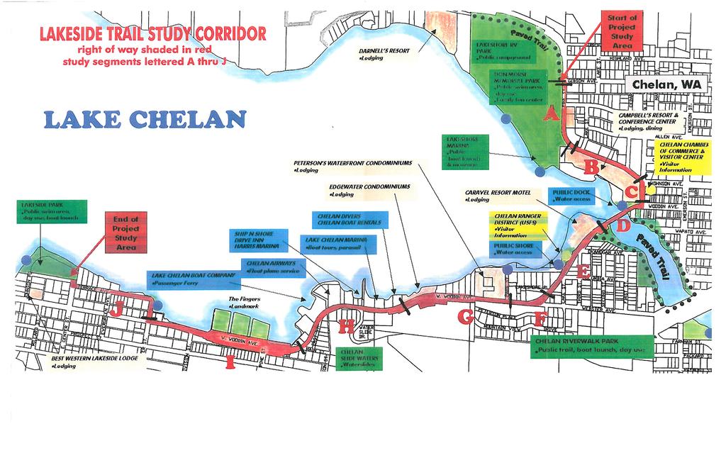
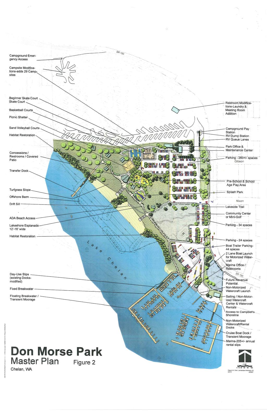
4 Boating Facility: 1 Community Dock/Marina: 5 Marina:3 (includes one approved marina not yet constructed) RV camp: 1 The City has planned for its parks in its Parks and Recreation Comprehensive Plan That Plan identifies the following existing City and non City facilities in the shoreline vicinity: Athletic Field Complex This park is located on the southern most portion of the downtown section of and is bordered by the River on one side and residential areas on three sides. This property is owned by the County PUD and leased to the City for recreation purposes. It is used by leagues and schools, and provides fields for a variety of sports as well as a children s play area. Centennial Park This park is located on Third Street on the south shore of Lake. This park was designed for passive use and taking advantage of views of Lake and the Valley. The park contains picnic tables, benches and limited duration parking. Don Morse Park This park is located on the north shore of Lake and is bordered by Highway 150, Lakeshore RV Park, Lakeshore Marina and Lake. Facilities at the site include: an 105,840 square foot swimming area with 1,350 feet of buoy line and beach bulkhead containing three stair areas and ramp, two docks, 2,000 square foot shallow pool with sand beach, day use lawn area with: picnic tables, picnic shelters, tennis, basketball and volleyball courts, a skate park, a children s play area, a concession and restroom building, walkways, a golf putting course, go cart race track and a sports equipment rental office. Lakeshore Marina This park is located on the north shore of Lake and is bordered by Highway 150, Don Morse Memorial Park, Campbell s Resort and Lake. Public moorage accommodates 68 boats. The park also includes a launch ramp. Additional facilities include a restroom building, boater pump out structure, a storage building, and breakwater. Lakeshore RV Park This park was designed primarily for recreational vehicle use and has water, wastewater, cable, and power hookups for 165 recreational vehicles. The park includes restroom/shower buildings and picnic tables. Lakeside Park This parcel of land is located on the south shore of Lake. Facilities at the park include: 17,500 square feet of sandy beach and swimming area, picnic tables, volleyball and basketball courts, and a restroom. Lakeside Trail The City is currently developing the first two phases of the Lakeside Trail. This is a Primary Trail that when completed will extend from Lakeside Park, along the southern shore of Lake, through downtown and up the north shore to the City limits. The trail will extend 2.2 miles when complete. Prepared by ICF 4 April 15, 2010
5 Riverwalk Park and Trail The County Public Utility District owns and maintains the one mile trail. The trail loops around the River and is located in the downtown core. The trail features benches, overlooks, and other amenities. The City of s Parks and Recreation Comprehensive Plan has calculated the demand for parks and trails citywide through 2014 based on levels of service: Mini, neighborhood, and community parks: demand for 24 acres Trails, pathways, bikeways: demand for 7.1 miles a portion of which is to be satisfied by the Lakeside Trail. In addition to the Parks and Recreation Comprehensive Plan, the City has developed a Lakeside Trail Feasibility Study (City of 2000). As described above, the City has begun implementation of the 2.2 mile trail with a 0.5 mile segment. Including both existing and proposed trails, the shoreline jurisdiction is anticipated to contain 8,225 linear feet of trails. Considering the whole Lakeside Trail, including the portions of the trail outside the 200 foot shoreline jurisdiction, the trail length is anticipated to equal 13,200 feet (2.5 miles). The City has implemented its parks, recreation, and trails plans through its capital facility plans, coordination with other agencies, and through private development projects that connect to public access features. An example of private development projects implementing public access includes the Sunset Condominiums and Marina project approved in This project will include a 75 double slip marina and floating breakwater connected to the public trail system. An example of agency coordination includes the City of s efforts to provide recommendations to the County PUD on the Lakeside Micro Park Plan. The City Council has accepted the following recommendations and plan for transmittal to the PUD: Continue public access without restriction Take any and all measures to keep the area open for public access by the public. The area is best known as a swim area and should be preserved for that activity. There should be limitations on canoe, kayak and other manpowered vessels. Arrange floating buoy boat tie downs Place the tie down boat buoys so as not to restrict or constrict the swim area for recreational swimmers or lap/distance swimmers. It should also preserve the open view of the lake whenever possible. Allow existing docks no new private docks to be built. Recommendation only as the Corp of Engineers, City and PUD will determine through the Shoreline Management Plan when adopted. Prepared by ICF 5 April 15, 2010
6 New Docks Allow for at least one and possibly more public docks along SR 97A. These docks would be for swimming and not motorized vessels. These docks could also be used for non motorized vessels such as kayaks, canoes, row boats, etc. Floating swim dock Place a floating swim dock in swim area. This recommendation would be with future implementation if needed. Chain blocking access Remove the posts and chain presently blocking the area and place park bench in its place. Placement of buoy lines in swim area This could be a future recommendation dependent on swim use and vessel conflicts. Signage Review the present signage to provide a better explanation of area use. Buoy Signage Place signage on buoys at entrance of area denoting swim area and local boat moorage only. Additional buoy markers Place additional buoys in the area of the water entrance denoting no wake. Community Parks and Recreation Standards The City s Parks and Recreation Comprehensive Plan includes level of service standards for different facilities community wide. These standards were considered in the development of specific parks and recreation improvements for the current and future population in s city limits and urban growth area. Facility Type Level of Service Standard Parks and Open Space acres/1000 population Mini 0.25 Neighborhood 2 Community 7 Regional 6 Open Space Areas 0.5 Trails miles/1000 population Trails 0.5 Pathways 0.25 Bikeways 0.5 Public Access Analysis & Objectives by Shoreline Reach Public access conditions are presented in order of numbered reaches as mapped in the Shoreline Inventory and Analysis Report for Shorelines in County and the Cities of Cashmere,, Entiat, Leavenworth, and Wenatchee dated March Prepared by ICF 6 April 15, 2010
7 It should be noted that City plans are fairly detailed for land within the City limits, but there is a deficiency of planning particularly on the north shore between Lakeside RV Park to Rocky Point, and on the south shore in the southern UGA area. As part of the County level SMP public access planning process, these areas can be addressed. Waterbody and Reach Current Shoreline Facilities Planned Shoreline Facilities Lake CCH L1 Visual access, SR 150. No adopted plans. The Valley Comprehensive Trail Plan identifies a proposed trail that parallels SR 150 and extends between downtown and Manson. Discussion This six-mile trail, known as the North Shore Pathway, would be a paved and lighted urban multi-use trail, separated from the highway by a physical barrier such as a wall, fence or curb. This plan has not been adopted by the City, but is a reference. CCH L2 Visual access, SR 150. Two community docks/marinas. CCH L3 Private Community No adopted plans. None Large lot residential uses. See above. Large lot residential uses. Developed residential parcels. Dock/Marina CCH L4 Private Marina None Developed Resort. CCH L5 None None Developed residential parcels. CCH L6 None None Developed residential parcels. CCH L7 Dietrich Road right-ofway None City Parks and Recreation Plan and Lord Acres Subarea Plan identify a potential neighborhood park in the vicinity of Decatur Road, outside of the shoreline jurisdiction. Developed residential parcels. CCH L8 None None Vacant property. CCH L9 None None Developed residential parcels. CCH L10 None None Developed residential. CCH L11 Lakeshore RV Park CCH L12 Don Morse Park; Boat launch; Marina See Don Morse Park Master Plan & Shoreline Study Prepared by ICF 7 April 15, 2010
8 Waterbody and Current Shoreline Planned Shoreline Reach Facilities Facilities Discussion CCH L13 Community Dock LakesideTrail Developed waterfront area. City Parks and future route of Lakeside Trail connecting Don Morse Regional Park and Lakeside City Park through this area. CCH L14 Visual Access (local street); Community Park None Area includes riverfront park at west end of Wapato Avenue. CCH L15 Visual Access (2 local streets) None Public land (government use) CCH L16 Visual Access (local None Developed downtown CCH L17 CCH L18 street); Visual Access (local street) Visual Access (local street); PUD Athletic Complex Potential ROW None property. Existing land use indicates several waterfront lots are government-owned. Existing recreational facility. CCH L19 None Riverwalk Park Trail City Parks and future portion of Riverwalk Park through this area. CCH L20 Boat launch; River Walk Park Trail; Potential ROW City Parks and future route of Riverwalk Park through this area. CCH L21 None None Developed urban area. CCH L22 River Walk Park None Existing recreational facility. CCH L23 None None Developed urban area. CCH L24 River Walk Park None Existing recreational facility. CCH L25 CCH L26 CCH L27 Visual Access (local street) Visual Access (local street) Visual Access (local street); Centennial Park; PUD Mini-park Trail Trail Trail City Parks and future route of Lakeside Trail through this area. City Parks and future route of Lakeside Trail through this area. City Parks and future route of Lakeside Trail through this area. Prepared by ICF 8 April 15, 2010
9 Waterbody and Reach CCH L28 Current Shoreline Facilities Visual Access (local street and US 97); Community dock CCH L29 Visual Access (US 97); Boating facility; CCH L30 Visual Access (US 97); Marina Planned Shoreline Facilities Trail Trail Trail, Future Marina Discussion City Parks and future route of Lakeside Trail through this area. City Parks and future route of Lakeside Trail through this area. Existing recreational facility. City Parks and future route of Lakeside Trail through this area. Approved development includes Sunset Marina and Breakwater with connection to Trail. CCH L31 Visual Access (US 97) Trail City Parks and future route of Lakeside Trail through this area. CCH L32 Visual Access (US 97); Private boat launch. CCH L33 Visual Access (local streets) CCH L34 Visual Access (US 97); Lakeside City Park; Boat Launch Trail; Lakeside Micro Park Plan Trail; Lakeside Micro Park Plan None City Parks and future route of Lakeside Trail through this area. See discussion of Micro Park in the Current and Future Facilities in Shoreline Jurisdiction section above. Developed residential area. City Parks and future route of Lakeside Trail through this area. See discussion of Micro Park in the Current and Future Facilities in Shoreline Jurisdiction section above. Existing recreational facilities. CCH L35 Visual Access (US 97) None Highway immediately adjacent to lake. CCH L36 Visual Access (US 97) None Large lots of city-owned property adjacent to shoreline jurisdiction. CCH L37 Visual Access (US 97); None Developed residential. Private boat launches River CCH R01 None None Public ownership Prepared by ICF 9 April 15, 2010
10 Waterbody and Current Shoreline Planned Shoreline Reach Facilities Facilities Discussion CCH R02 None None Public ownership CCH R03 None None Public ownership CCH R04 None None Public ownership CCH R05 None None Public ownership CCH R01R None Trail City Parks and future portion of Riverwalk Park through this area. CCH R01L None None Public ownership CCH R02L None None Public ownership CCH R03L Visual Access None Public ownership CCH R04L PUD Athletic Complex None Existing recreational facility. Implementation To be provided. Anticipated to integrate with City comprehensive and parks plans and identify actions to be taken to develop public shoreline access to shorelines on public property, recommended projects, and/or requirements for shoreline permits, recognizing that the planning process may also justify more flexible off site or special area public access provisions. Supporting Maps The following attached maps are provided for reference and in support of the shoreline public access plan: Public Access maps prepared for the Shoreline Master Program update, April 14, 2010 Lakeside Trail Study Corridor Map, 2000 Don Morse Park Master Plan, 2007 Prepared by ICF 10 April 15, 2010
11 DRAFT SR 150 Lake Area of Interest in Red Public Access 01 [ Feet 1 inch equals 800 feet April 14, 2010 Data: WA DOE, WA OFM, TPL, TNC, County, WA State Parks, WNF Public Access, Parks, and Other Public Lands Boat Launch!9 Campground! Comm. Dock/Marina Fishing Access!Ë Horse Camp!x Marina! Other Boating Facility!5!¼ RV Camp!* Ski Area!/ SnoPark!F Trailhead!]!% Picnic Area Visitor Info Site Winter Rec. Facility with Boatlaunch Parks Other Public and Protected Lands Potential ROW Access View Corridors Hiking Trails Proposed Trails Highways Railroads Parcels Jurisdiction City Boundaries UGA Boundaries Shoreline jurisdiction boundaries depicted on this map are approximate. They have not been formally delineated or surveyed and are intended for planning purposes only. Additional site-specific evaluation may be needed to confirm/verify information shown on this map.
12 DRAFT SR 150!!! SR 971 US ALT 97 Area of Interest in Red US ALT 97 Lake C helan Lakeside City Park Public Access 02 [ Feet 1 inch equals 800 feet April 14, 2010 Data: WA DOE, WA OFM, TPL, TNC, County, WA State Parks, WNF Public Access, Parks, and Other Public Lands Boat Launch!9 Campground! Comm. Dock/Marina Fishing Access!Ë Horse Camp!x Marina! Other Boating Facility!5!¼ RV Camp!* Ski Area!/ SnoPark!F Trailhead!]!% Picnic Area Visitor Info Site Winter Rec. Facility with Boatlaunch Parks Other Public and Protected Lands Potential ROW Access View Corridors Hiking Trails Proposed Trails Highways Railroads Parcels Jurisdiction City Boundaries UGA Boundaries Shoreline jurisdiction boundaries depicted on this map are approximate. They have not been formally delineated or surveyed and are intended for planning purposes only. Additional site-specific evaluation may be needed to confirm/verify information shown on this map.
13 DRAFT! City Golf Course SR 150 Lakeside City Park Lake US ALT 97 Lakeside Micro Park Planned Sunset Marina & Breakwater Connected to Public Trail!x!x Lakeside City Park Area of Interest in Red Public Access 03 [ Feet 1 inch equals 800 feet April 14, 2010 Data: WA DOE, WA OFM, TPL, TNC, County, WA State Parks, WNF Public Access, Parks, and Other Public Lands Boat Launch!9 Campground! Comm. Dock/Marina Fishing Access!Ë Horse Camp!x Marina! Other Boating Facility!5!¼ RV Camp!* Ski Area!/ SnoPark!F Trailhead!]!% Picnic Area Visitor Info Site Winter Rec. Facility with Boatlaunch Parks Other Public and Protected Lands Potential ROW Access View Corridors Hiking Trails Proposed Trails Highways Railroads Parcels Jurisdiction City Boundaries UGA Boundaries Shoreline jurisdiction boundaries depicted on this map are approximate. They have not been formally delineated or surveyed and are intended for planning purposes only. Additional site-specific evaluation may be needed to confirm/verify information shown on this map.
14 DRAFT City Golf Course City Golf Course SR 150 Lakeshore RV Park!¼ Don Morse Park Lake!x Ball Fields! US ALT 97 Steps to Lakefront!!! River Park Centennial PUDPark Mini Park River Walk Park!x Hwy 97 Intersection US ALT 97 Ball Fields Chela n River Area of Interest in Red Public Access 04 [ Feet 1 inch equals 800 feet April 14, 2010 Data: WA DOE, WA OFM, TPL, TNC, County, WA State Parks, WNF Public Access, Parks, and Other Public Lands Boat Launch!9 Campground! Comm. Dock/Marina Fishing Access!Ë Horse Camp!x Marina! Other Boating Facility!5!¼ RV Camp!* Ski Area!/ SnoPark!F Trailhead!]!% Picnic Area Visitor Info Site Winter Rec. Facility with Boatlaunch Parks Other Public and Protected Lands Potential ROW Access View Corridors Hiking Trails Proposed Trails Highways Railroads Parcels Jurisdiction City Boundaries UGA Boundaries Shoreline jurisdiction boundaries depicted on this map are approximate. They have not been formally delineated or surveyed and are intended for planning purposes only. Additional site-specific evaluation may be needed to confirm/verify information shown on this map.
15 DRAFT US ALT 97 US ALT 97 Ball Fields R iver SR 150 Area of Interest in Red SR 150 Public Access 06 [ Feet 1 inch equals 800 feet April 14, 2010 Data: WA DOE, WA OFM, TPL, TNC, County, WA State Parks, WNF Public Access, Parks, and Other Public Lands Boat Launch!9 Campground! Comm. Dock/Marina Fishing Access!Ë Horse Camp!x Marina! Other Boating Facility!5!¼ RV Camp!* Ski Area!/ SnoPark!F Trailhead!]!% Picnic Area Visitor Info Site Winter Rec. Facility with Boatlaunch Parks Other Public and Protected Lands Potential ROW Access View Corridors Hiking Trails Proposed Trails Highways Railroads Parcels Jurisdiction City Boundaries UGA Boundaries Shoreline jurisdiction boundaries depicted on this map are approximate. They have not been formally delineated or surveyed and are intended for planning purposes only. Additional site-specific evaluation may be needed to confirm/verify information shown on this map.
16 DRAFT US ALT 97 US 97 River Columbia D o u g l a s C o u n t y Area of Interest in Red SR 150 Public Access 05 [ Feet 1 inch equals 800 feet April 14, 2010 Data: WA DOE, WA OFM, TPL, TNC, County, WA State Parks, WNF Public Access, Parks, and Other Public Lands Boat Launch!9 Campground! Comm. Dock/Marina Fishing Access!Ë Horse Camp!x Marina! Other Boating Facility!5!¼ RV Camp!* Ski Area!/ SnoPark!F Trailhead!]!% Picnic Area Visitor Info Site Winter Rec. Facility with Boatlaunch Parks Other Public and Protected Lands Potential ROW Access View Corridors Hiking Trails Proposed Trails Highways Railroads Parcels Jurisdiction City Boundaries UGA Boundaries Shoreline jurisdiction boundaries depicted on this map are approximate. They have not been formally delineated or surveyed and are intended for planning purposes only. Additional site-specific evaluation may be needed to confirm/verify information shown on this map.
17 DRAFT US 97 River SR 150 Long Park Long Park Long Park Long Park D o u g l a s C o u n t y Area of Interest in Red C olumbia River Public Access 07 [ Feet 1 inch equals 800 feet April 14, 2010 Data: WA DOE, WA OFM, TPL, TNC, County, WA State Parks, WNF Public Access, Parks, and Other Public Lands Boat Launch!9 Campground! Comm. Dock/Marina Fishing Access!Ë Horse Camp!x Marina! Other Boating Facility!5!¼ RV Camp!* Ski Area!/ SnoPark!F Trailhead!]!% Picnic Area Visitor Info Site Winter Rec. Facility with Boatlaunch Parks Other Public and Protected Lands Potential ROW Access View Corridors Hiking Trails Proposed Trails Highways Railroads Parcels Jurisdiction City Boundaries UGA Boundaries Shoreline jurisdiction boundaries depicted on this map are approximate. They have not been formally delineated or surveyed and are intended for planning purposes only. Additional site-specific evaluation may be needed to confirm/verify information shown on this map.
18
19
20
City of Chelan Shoreline Public Access Plan
 City of Chelan Shoreline Public Access Plan This City of Chelan Shoreline Public Access Plan documents how the City has planned for parks and recreation in the community, particularly along Lake Chelan
CHAPTER 5. Chapter 5 Recreation Element
 CHAPTER 5 Recreation Element Chapter 5 Recreation Element The Recreation Element of the Meyers Area Plan is a supplement to the Recreation Element of the TRPA Regional Plan and the El Dorado County General
2. Goals and Policies. The following are the adopted Parks and Trails Goals for Stillwater Township:
 D. PARKS AND TRAILS 1. Introduction Stillwater Township s population is relatively low, with most residents living on rural residences on large lots. The need for active park space has been minimal in
Acquisition in fee simple of approximately one-half acre of property on the shore of Spring Lake to expand the Lakeside Beach Park.
 Lakeside Beach TF00-136 $122,550.00 in fee simple of approximately one-half acre of property on the shore of Spring Lake to exp the Lakeside Beach. 2000 River Ravines TF00-150 $910,000.00 in fee simple
Blueways: Rivers, lakes, or streams with public access for recreation that includes fishing, nature observation, and opportunities for boating.
 Parks, Open Space and Trails PRINCE WILLIAM COUNTY 2008 COMPREHENSIVE PLAN TRAILS PLAN CONTENTS The components of the trails plan are: Intent Definitions Goals, Policies, and Action Strategies Trails Map
Lake Tahoe Shoreline Plan 03 Policy Topic: Access Issues
 Lake Tahoe Shoreline Plan 03 Policy Topic: Access Issues V9 Last Updated 03.10.2017 1 Brief Description Physical access to the waters of Lake Tahoe is one of the key issues surrounding the Shoreline Plan
MUNICIPALITY OF ANCHORAGE
 MUNICIPALITY OF ANCHORAGE ANCHORAGE PARKS & RECREATION Memorandum PRC 08-56 DATE: 5 August 2008 TO: FROM: SUBJECT: Parks & Recreation Commission Holly Spoth-Torres, Park Planner PRC 08-56 Far North Bicentennial
AGENDA ITEM 5 D WAKULLA ENVIRONMENTAL INSTITUTE (WEI) TRAIL FEASIBILITY STUDY
 TRAIL FEASIBILITY STUDY") March 19, 2018 AGENDA ITEM 5 D WAKULLA ENVIRONMENTAL INSTITUTE (WEI) TRAIL FEASIBILITY STUDY TYPE OF ITEM: Action STATEMENT OF ISSUE The Wakulla Environmental Institute (WEI) Trail is one of several trails
March 19, 2018 AGENDA ITEM 5 D WAKULLA ENVIRONMENTAL INSTITUTE (WEI) TRAIL FEASIBILITY STUDY TYPE OF ITEM: Action STATEMENT OF ISSUE The Wakulla Environmental Institute (WEI) Trail is one of several trails
Cascade River State Park Management Plan Amendment
 This document is made available electronically by the Minnesota Legislative Reference Library as part of an ongoing digital archiving project. http://www.leg.state.mn.us/lrl/lrl.asp Cascade River State
Airport Planning Area
 PLANNING AREA POLICIES l AIRPORT Airport Planning Area LOCATION AND CONTEXT The Airport Planning Area ( Airport area ) is a key part of Boise s economy and transportation network; it features a multi-purpose
Proposal to Redevelop Lower Kananaskis River-Barrier Lake. Bow Valley Provincial Park. Frequently Asked Questions
 Proposal to Redevelop Lower Kananaskis River-Barrier Lake Bow Valley Provincial Park Frequently Asked Questions What is being proposed? What are the details of the proposal? Where is the project area located?
Chapter 6. Action Program. Heart of the Lakes Area Recreation Plan
 Heart of the Lakes Area Recreation Plan 1. Design and construct the following trails (please see the following map): a. the Speedway Trail 1) primary pathway the main trail 2) secondary pathway the proposed
The Baker/Carver Regional Trail is intended to
 Section V Design Guidance The Baker/Carver Regional Trail is intended to safely accommodate 183,000 annual visits, an array of non-motorized uses, a variety of skill levels, and persons with special needs.
City of Haslett. City of East Lansing. City of East Lansing
 Central Park North (Nancy L. Moore Park) Lake Park North Expansion White Park Expansion #2 White Park Expansion #1 County East East Haslett East East TF87-212 Acquisition $90,000.00 Park. TF08-138 Acquisition
Blue River Trail Master Plan JSA to Town Hall June 2004
 Blue River Trail Master Plan JSA to Town Hall June 2004 Prepared for: Silverthorne Town Council Silverthorne SPORT Committee Department of Recreation and Culture Silverthorne Public Works Silverthorne
CRANE LAKE TRAILS NETWORK AND SPACES
 CRANE LAKE TRAILS NETWORK AND SPACES AREA TRAILS COMMUNITY TRAILS GOLD COAST TRAIL LAKE PARK OPTION ONE LAKE PARK OPTION TWO OVERFLOW TRAILHEAD PARKING THE GATE AREA TRAILS Trails are a major resource
M E S T I Z O C U R T I S P A R K
 ARAPAHOE CONNECTION TO BUS ROUTE AT ND AND LAWRENCE, FUTURE LIGHT RAIL STATION LEGEND SOCIAL TRAIL FLAGSTONE PAVING TO RESTORE/MAINTAIN CONCRETE PAVING DIAGONAL CURVILINEAR SOCIAL ROUTE IS OUT OF HISTORIC
Chair and Members of Harbour East - Marine Drive Community Council. Brad Anguish, Director, Parks and Recreation
 P.O. Box 1749 Halifax, Nova Scotia B3J 3A5 Canada Item No. 15.1.1 Harbour East-Marine Drive Community Council December 3, 2015 TO: SUBMITTED BY: Chair and Members of Harbour East - Marine Drive Community
NORTHWEST SECTION CONTENTS: CLEVELAND PARK FOLWELL PARK RYAN LAKE PARK VICTORY PRAIRIE DOG PARK VICTORY PARK
 NORTHWEST SECTION CONTENTS: CLEVELAND PARK FOLWELL PARK RYAN LAKE PARK VICTORY PRAIRIE DOG PARK VICTORY PARK LUCY LANEY COMMUNITY SCHOOL N 33RD AVE N 33RD AVE SINGLE-FAMILY RESIDENTIAL MULTI-USE DIAMOND
Section XIII. Cost Estimates
 Section XIII Cost Estimates 13-01. INTRODUCTION SECTION XIII COST ESTIMATES a. General. Preliminary cost estimates for development of proposed new and renovation or replacement actions at Lake Shelbyville
4.0 Context for the Crossing Project
 4.0 Context for the Crossing Project This section provides background information about key features of the North Douglas Crossing project area, and opportunities and constraints. This information is important
Georgetown-Lewes Rail/Trail Study. Rail/Trail Study: Cool Spring to Cape Henlopen State Park New Road Extension (House Resolution No.
 Georgetown-Lewes Rail/Trail Study Rail/Trail Study: Cool Spring to Cape Henlopen State Park New Road Extension (House Resolution No. 47) August 22, 2011 Presentation Outline Background Benefits Statewide
J. Recreation Plan of Conservation and Development. The Town of Hebron. Section 2. Preservation of Unique Assets. 1 P a g e
 The Town of Hebron Section 2 2014 Plan of Conservation and Development Preservation of Unique Assets J. Recreation Open spaces, parks, sports fields, and recreational programs are considered essential
Proposal to Redevelop Lower Kananaskis River-Barrier Lake. Bow Valley Provincial Park
 Frequently Asked Questions Proposal to Redevelop Lower Kananaskis River-Barrier Lake Bow Valley Provincial Park Frequently Asked Questions What has been decided? What are the details of the plan? What
Welcome! INTRODUCTION. Tell us what you think! Comment forms are provided for your feedback
 Welcome! Comment forms are provided for your feedback Tell us what you think! INTRODUCTION The City of Salmon Arm s O cial Community Plan (OCP) and its Parks and Recrea on Master Plan (2012) both iden
TRUCKEE TAHOE AIRPORT DISTRICT BOARD OF DIRECTOR STAFF REPORT
 AGENDA ITEM: 11 TRUCKEE TAHOE AIRPORT DISTRICT BOARD OF DIRECTOR STAFF REPORT AGENDA TITLE: MEETING DATE: January 24, 2018 PREPARED BY: NTPUD Agency Partnership Opportunity, Multi-Use Trailhead Access
Business Item No XXX. Proposed Action That the Metropolitan Council approve the Coon Creek Regional Trail Master Plan.
 Business Item No. 2015-XXX Metropolitan Parks and Open Space Commission Meeting date: July 7, 2015 For the Community Development Committee meeting of July 20, 2015 For the Metropolitan Council meeting
PIONEER PARK. City of Des Peres Parks Master Plan. SWT Design 46 INTRODUCTION
 PIONEER PARK INTRODUCTION Pioneer Park is a 7 acre neighborhood park located east of Interstate 270 and south of Manchester Road along Tallie Road. The park is situated in a residential neighborhood with
City of Durango 5.8 FUNDING TRAILS DEVELOPMENT
 5.8 FUNDING TRAILS DEVELOPMENT The City has been successful in establishing dedicated local funding sources as well as applying for grants to develop the City s trail system, having received nearly $2.4
Martinez General Plan 2035 White Paper TRAILS
 Martinez General Plan 2035 White Paper TRAILS November 2016 The Issue The draft Martinez General Plan 2035 and Draft Program Environmental Impact Report were released for public review on September 15,
VOLUME II APPENDIX F DETAILED PHYSICAL DESCRIPTION OF PROJECT RESERVOIRS AND LANDS
 VOLUME II APPENDIX F DETAILED PHYSICAL DESCRIPTION OF PROJECT RESERVOIRS AND LANDS THE CENTRAL NEBRASKA PUBLIC POWER AND IRRIGATION DISTRICT FERC PROJECT NO. 1417 PHYSICAL DESCRIPTION OF PROJECT LANDS
RECREATION MANAGEMENT PLAN WELLS HYDROELECTRIC PROJECT FERC NO. 2149
 RECREATION MANAGEMENT PLAN WELLS HYDROELECTRIC PROJECT FERC NO. 2149 May 2010 Prepared by: Public Utility District No. 1 of Douglas County Copyright 2010. Public Utility District No. 1 of Douglas County.
Rating: 5.0 (scale of 1-10)
") 95 Community Trail System Groundcover: 2-metre paved path, 1- metre grass buffer on either side. Location: Fort St. John Ownership: City of Fort St. John Rating: 5.0 (scale of 1-10) Strategic value: Linear
95 Community Trail System Groundcover: 2-metre paved path, 1- metre grass buffer on either side. Location: Fort St. John Ownership: City of Fort St. John Rating: 5.0 (scale of 1-10) Strategic value: Linear
4.0 FACILITIES INVENTORY
 4.0 FACILITIES INVENTORY 4.1 PARK LEVEL OF SERVICE STANDARDS (LOS) Based on current City of Longview Parks and Recreation Level of Service (LOS) Standards (Figure G), the City currently has a deficiency
Park Design and Location Criteria
 Park Design and Location Criteria This section is presented in the interest of assisting park and recreation agencies in the development of a system of parks and recreation areas. A recreation system is
Northeast Quadrant Distinctive Features
 NORTHEAST QUADRANT Northeast Quadrant Distinctive Features LAND USE The Northeast Quadrant includes all the area within the planning area that is east of Interstate 5 and to the north of State Route 44.
METROPOLITAN COUNCIL 390 North Robert Street, St. Paul, MN Phone (651) TDD (651)
 TDD (651)") DATE: March 27, 2012 METROPOLITAN COUNCIL 390 North Robert Street, St. Paul, MN 55101 Phone (651) 602-1000 TDD (651) 291-0904 TO: Metropolitan Parks and Open Space Commission FROM: Arne Stefferud, Planning
DATE: March 27, 2012 METROPOLITAN COUNCIL 390 North Robert Street, St. Paul, MN 55101 Phone (651) 602-1000 TDD (651) 291-0904 TO: Metropolitan Parks and Open Space Commission FROM: Arne Stefferud, Planning
CHAPTER 4 EXISTING PARKS AND RECREATION FACILITIES INVENTORY
 CHAPTER 4 EXISTING PARKS AND RECREATION FACILITIES INVENTORY Existing park and recreation sites and facilities provide the basis upon which to build a park and recreation plan for the city. This inventory
CHAPTER 9. PARKS, RECREATION, TRAILS AND NATURAL AREA RESOURCES
 CHAPTER 9. PARKS, RECREATION, TRAILS AND NATURAL AREA RESOURCES The forms of recreation chosen by residents and visitors in the CBJ are as diverse as the population. Many people choose to recreate in developed
Everett Riverwalk Life style explore
 Life style explore Project Overview The 217-acre Everett Riverfront redevelopment is visible from I-5 with traffic counts charted at 170,000+ vehicles per day with direct freeway access from 4-way interchange.
Business Item No
 Metropolitan Parks and Open Space Commission Meeting date: February 6, 2018 For the Community Development Committee meeting of February 20, 2018 For the Metropolitan Council meeting of February 28, 2018
Please Tell Us What You Think: Candidate Sites for Recreation Business Activities
 Please Tell Us What You Think: Candidate Sites for Recreation Business Activities Background In January 2015, the Washington State Parks and Recreation Commission (Commission) approved some forms of privately
Schoolcraft Township is located in northeast Houghton County. A portion of the township borders Keweenaw County and Lake Superior.
 COMMUNITY DESCRIPTION Schoolcraft Township is located in northeast Houghton County. A portion of the township borders Keweenaw County and Lake Superior. The township is largely rural but has one main population
Southwest Quadrant Distinctive Features
 SOUTHWEST QUADRANT Southwest Quadrant Distinctive Features LAND USE The 31.17 square mile Southwest Quadrant includes all the area within the planning area west of I-5 and south of the Sacramento River.
how it started where we are now what is coming up NEW WESTMINSTER WATERFRONT PARK THE RIVER THE PAST THE PEOPLE
 how it started Downtown Waterfront Park How It Started March 2009 City of New Westminster Purchases 3.2 Hectare Westminster Pier Site March 2009 City of New Westminster and Design Team develop plan for
Jefferson County Non-Motorized Transportation and Recreational Trails Plan 2010
 Chapter 8: Goals and objectives Plan Update: The following update presents general principles, goals, and objectives related to non-motorized transportation facilities as a component of the overall transportation
CHAPTER 4 -- THE LAND USE PLAN: DESCRIPTIONS AND POLICIES FOR THIRTEEN PLANNING AREAS
 CHAPTER 4 -- THE LAND USE PLAN: DESCRIPTIONS AND POLICIES FOR THIRTEEN PLANNING AREAS NORTH CENTRAL CAC PLANNING AREA 4.4 FORT BRAGG CITY LIMIT TO HARE CREEK PLANNING AREA (Includes Noyo) The Noyo community
Understanding the caring capacity of the visitor experience Provide facilities to support a high level user experience Address visual quality through
 Understanding the caring capacity of the visitor experience Provide facilities to support a high level user experience Address visual quality through recreation ecological restoration opportunities Collaboration
Outdoor Developed Areas
 The United States Access Board is an independent federal agency that promotes equality for people with disabilities through leadership in accessible design and the development of accessibility guidelines
What s covered. What s not covered. Options for those not covered. ABA Coverage
 The United States Access Board is an independent federal agency that promotes equality for people with disabilities through leadership in accessible design and the development of accessibility guidelines
Chapter eight. Parks and Recreation. Introduction. Crystal Lake Park District
 Chapter eight Parks and Recreation Introduction One of the indicators of quality of life in a city is the parks and recreation system. The City of Crystal Lake is fortunate to have an excellent parks and
Flow Stand Up Paddle Board Parkway Plan Analysis
 Regional Parks Department Jeffrey R. Leatherman, Director County of Sacramento Divisions Administration Golf Leisure Services Maintenance Rangers Therapeutic Recreation Services Flow Stand Up Paddle Board
1. Overview of Atlantic Highlands and Its Waterfront
 Atlantic Highlands 1. Overview of Atlantic Highlands and Its Waterfront Atlantic Highlands: Satellite Photo by USGS 1.1. Geographical Overview The Borough of Atlantic Highlands is on Sandy Hook Bay. It
LONG TERM (OPERATION) IMPACTS AND POTENTIAL MITIGATION
 IMPACTS AND POTENTIAL MITIGATION") 3.6 This chapter provides a project-level analysis of potential impacts to recreation sites in the study area including parks, natural areas, open spaces, trails, and playfields, as well as amenities such
3.6 This chapter provides a project-level analysis of potential impacts to recreation sites in the study area including parks, natural areas, open spaces, trails, and playfields, as well as amenities such
NEWBORO AND PORTLAND HARBOUR REDVELOPMENT PLANS
 INTRODUCTION The Municipal docks in both Newboro and Portland were transferred to the Township of Rideau Lakes by Parks Canada in 2002. Little has been done to improve the docks physical condition or role
Section II. Planning & Public Process Planning for the Baker/Carver Regional Trail began in 2010 as a City of Minnetrista initiative.
 Section II Planning & Public Process Planning for the began in 2010 as a City of initiative. city staff began discussions with the Park District on the possibility of a north/south regional trail connection
Auburn Trail / Ontario Pathways Trail Connector Feasibility Study Public Information Meeting Wednesday, August 22, 2012
 Auburn Trail / Ontario Pathways Trail Connector Feasibility Study Public Information Meeting Wednesday, August 22, 2012 Purpose of Feasibility Study Purpose Evaluate the feasibility of constructing a multiuse
NORTH HEMPSTEAD BEACH PARK MASTER PLAN
 NORTH HEMPSTEAD BEACH PARK MASTER PLAN COMMUNITY DESIGN CHARRETTE Supervisor Judi Bosworth Viviana L. Russell Peter J. Zuckerman Angelo P. Ferrara Anna M. Kaplan Lee R. Seeman Dina M. De Giorgio VISIONING
Lake Myra County Park. Wake County, North Carolina Community Forum #2 June 12, 2008
 Lake Myra County Park Wake County, North Carolina Community Forum #2 June 12, 2008 Welcome and Introduction Meeting Agenda Welcome Introductions of Project Team Master Plan Process Community Forum #1 Updates
Dakota County Planning Commission Advisory Committee Meeting Minutes Date: May 23, 2017 Time: 6:00 p.m. to 8:30 p.m.
 Dakota County Planning Commission Advisory Committee Meeting Minutes Date: May 23, 2017 Time: 6:00 p.m. to 8:30 p.m. Members Present Staff Present Mike Greco Trinity Augesen Vacant Lori Hansen Jill Smith
Regional Wayfinding Sign Strategy Thurston County Trails 2017
 Regional Wayfinding Sign Strategy Thurston County Trails 2017 Partners: Members and partnering organizations of the Thurston Thrives Community Design Action Team City of Lacey, City of Olympia, City of
FEASIBILITY CRITERIA
 This chapter describes the methodology and criteria used to evaluate the feasibility of developing trails throughout the study areas. Land availability, habitat sensitivity, roadway crossings and on-street
Committee Report. Community Development Committee For the Metropolitan Council meeting of August 12, Business Item No.
 Committee Report Business Item No. 2015-168 Community Development Committee For the Metropolitan Council meeting of August 12, 2015 Subject: Coon Creek Regional Trail Master Plan, Anoka County Proposed
City of Oak Harbor Parks & Descriptions
 City of Oak Harbor Parks & Descriptions North West Section Koetje Park - NE 7 th Avenue (3.5 acres) Neighborhood and Community Park with playgrounds on one tot lot, one soccer/practice field, picnic tables,
Classifications, Inventory and Level of Service
 Classifications, Inventory and Level of Service Section 3 Kenmore Park, Recreation and Open Space Plan 1 P a g e Classifications and Inventory Park Classifications Kenmore classifies its parks based upon
2016 Regional Transportation Alternatives Program (TAP) Grant Application
 Grant Application") 2016 Regional Transportation Alternatives Program (TAP) Grant Application PROJECT TITLE: Yelm-Tenino Trail Extension Feasibility Study TRPC use only GENERAL PROJECT INFORMATION Agency or Organization City
2016 Regional Transportation Alternatives Program (TAP) Grant Application PROJECT TITLE: Yelm-Tenino Trail Extension Feasibility Study TRPC use only GENERAL PROJECT INFORMATION Agency or Organization City
Lafourche Parish Government REQUEST FOR QUALIFICATIONS. Landscape Architectural Services
 Lafourche Parish Government REQUEST FOR QUALIFICATIONS Landscape Architectural Services Bayou Lafourche Parish Multi-Use Path Feasibility Study Phase 1 And Bayou Lafourche Parish Multi-Use Path Feasibility
Dungeness Recreation Area County Park Master Plan
 Dungeness Recreation Area County Park Public Outreach Meeting October 10, 2007 Project Overview USFWS Site Dungeness Recreation Area County Park Meeting Objectives: Re-Introduce project; provide status
O REGON TRAILS SUMMIT. Oregon Trails Summit. Rogue River National Forest
 O REGON TRAILS SUMMIT Oregon Trails Summit 2014 Rogue River National Forest OREGON TRAILS 2015: A VISION FOR THE FUTURE The 2015-2024 Oregon Statewide Trails Plan Why do a trails plan? 2005-2014 Oregon
ROYAL GORGE PARK and RECREATION AREA. A Feat of Natural and Man-Made Engineering
 ROYAL GORGE PARK and RECREATION AREA A Feat of Natural and Man-Made Engineering As Growth Resumed in the 1870 s Town Leaders Began to Envision a Tourist Industry. The Arkansas River Canyon was advertised
MEETING MINUTES District 1 Trail Planning Meeting 1
 MEETING MINUTES District 1 Trail Planning Meeting 1 June 1, 2017 2:00 PM 3:30 PM City of Two Harbors 2:00 Introductions Attendees: Lisa Austin, MnDOT Bryan Anderson, MnDOT Jasna Hadzic-Stanek, MnDOT Justin
CLEVELAND PARK LOCATION AND HISTORY EXISTING CONDITIONS AND CHARACTER LOCATION
 CLEVELAND PARK LOCATION LOCATION AND HISTORY Attempts to create a neighborhood park and playground in the Cleveland neighborhood began in 1926, when the park board designated for acquisition the block
CONTENTS. 1 Introduction Always Moving Forward while Building on the Past A Dynamic Destination... 5
 2010 STRUCTURE PLAN - 2 - CONTENTS 1 Introduction... 5 1.1 Always Moving Forward while Building on the Past... 5 1.2 A Dynamic Destination... 5 2 Map A... 6 Exhibition Place and its Neighbours... 7 3 Demonstration
Preferred Recreation Recommendations Stemilt-Squilchuck Recreation Plan March 2018
 Preferred Recreation Recommendations Stemilt-Squilchuck Recreation Plan March 2018 Below are the recommended recreation ideas and strategies that package together the various recreation concepts compiled
APPENDIX OFFICIAL MAP ORDINANCE OF HAMILTONBAN TOWNSHIP OFFICIAL MAP NARRATIVE
 APPENDIX A OFFICIAL MAP ORDINANCE OF HAMILTONBAN TOWNSHIP OFFICIAL MAP NARRATIVE INTRODUCTION: The Official Map of Hamiltonban Township has been prepared to identify those lands and features that Hamiltonban
Camping (Primitive) Camping (RV) Electrical Potable Water Grill Established Fire Pit Picnic Table
 Camping (RV) Electrical Potable Water Grill Established Fire Pit Picnic Table") Alden - 9th Road River Mile 777 Map: 38.20833, -98.32031 Managing Agency: Kansas Department of Wildlife, Parks & Tourism Nearest Community: Alden, Rice County Kansas Developed Amenities Provided Parking
Alden - 9th Road River Mile 777 Map: 38.20833, -98.32031 Managing Agency: Kansas Department of Wildlife, Parks & Tourism Nearest Community: Alden, Rice County Kansas Developed Amenities Provided Parking
Corabelle Park. Inventory. Future Development
 Corabelle Park Size: Approximately 4 acres Site Description: Corabelle Park is a relatively new park within the Murray County Park System. It is located on the south side of Corabelle Lake just off gravel
CITY OF BULLHEAD CITY
 CITY OF BULLHEAD CITY COUNCIL COMMUNICATION MEETING DATE: June 7, 2016 SUBJECT: Bullhead City River Access- City streets/rights of ways DEPT OF ORIGfN: Office of the City Manager DATE SUBMITTED: May 30,2016
Hazlet. 1. Overview of Hazlet and Its Waterfront. Hazlet Township. 1.1 Geographic Overview
 Hazlet 1. Overview of Hazlet and Its Waterfront 1.1 Geographic Overview Hazlet Township is located in Monmouth County. The Township has a land area of 5.6 square miles. Situated in the Bayshore region
Kansas (KAW) River History
 River History") Kansas (KAW) River History The first map of the Kansas River is dated back to 1718. Lewis and Clark spent 3 days camped at Kaw Point at the confluence of the Kansas and Missouri Rivers. Kansas (KAW) River
Kansas (KAW) River History The first map of the Kansas River is dated back to 1718. Lewis and Clark spent 3 days camped at Kaw Point at the confluence of the Kansas and Missouri Rivers. Kansas (KAW) River
Rogue River Access and Management Plan Draft Alternatives
 Rogue River Access and Management Plan Draft Alternatives The Rogue River Access and Management Plan was initiated in December, 2011 and is being led by Jackson County Parks (JCP) and Oregon Department
4.19 Parks, Recreation, and Conservation Lands
 interchange would have on the Reed Paige Clark Homestead located on the north side of Stonehenge Road. Alternative D would also affect Palmer Homestead, E.F. Adams House, and Knapp Brothers Shoe Manufacturing
Economic Development and Tourism
 SECTION 4 SECTION 4 Economic Development and Tourism 4. Economic Development and Tourism Tourism plays a very important role in Niagara s economy, providing employment and generating business for support
Lake Waconia Regional Park 6. Lake Waconia Regional Park
 Lower Lakeshore Trail Interpretive/Adventure Trail Multiple Seating & Observation Areas Flexible Day Use Recreation Area Docks/Fishing Group Camping Group Day Use Space Winter Gathering/Event Space -Season
NAVAJO COMMUNITY PLAN
 NAVAJO COMMUNITY PLAN Prepared by the NAVAJO COMMUNITY PLANNERS and THE CITY OF SAN DIEGO City of San Diego Planning Department 202 C Street, MS 4A San Diego, CA 92101 Printed on recycled paper. This information,
North Shore Lacamas Lake
 North Shore Lacamas Lake January 27, 2017 A Vision for Conservation and Recreation Acknowledgements Funding Funding for this planning effort was provided by the City of Camas and the Columbia Land rust
DEPARTMENT OF PLANNING, COMMUNITY & ECONOMIC DEVELOPMENT
 DEPARTMENT OF PLANNING, COMMUNITY & ECONOMIC DEVELOPMENT DATE: December 11, 2015 TO: FROM: SUBJECT: City Council Kevin Cricchio, AICP Associate Planner Department of Planning, Community & Economic Development
APPLICATION FOR SITE DEVELOPMENT PLAN LETTER OF INTENT Amended
 Est. 1982 Est. 1982 Urban Planning Community Design Landscape Architecture 731 North Weber Street, Suite 10, Colorado Springs, CO 80903, 719 633-9700 http://www.gumanltd.com/ Members American society of
COPPER HERITAGE TRAIL CONCEPTUAL PLAN 2011
 COPPER HERITAGE TRAIL CONCEPTUAL PLAN 2011 A Proposed 40 Mile Non-Motorized Rail Trail Route Connecting The Historic Communities Of the Copper Country Prepared For: Western Upper Peninsula Health Department
HOMEWOOD MOUNTAIN RESORT SKI AREA MASTER PLAN EIR/EIS
 18.0 RECREATION 18.1 ENVIRONMENTAL SETTING 18.1.1 Project Area Homewood is an unincorporated community in Placer County, California, located on the west shore of Lake Tahoe. The ski resort, located a few
Appendix 4.1 L. No-Build Project Descriptions
 Appendix 4.1 L No-Build Project Descriptions No-Build Projects New Bedford A new traffic signal system was installed and activated in early 2009 at the intersection of King s Highway and Mount Pleasant
Chapter 2: Summary of Existing Open Space System
 Chapter 2: Summary of Existing Open Space System In 1976, the Wake County Board of Commissioners established the Wake County Parks and Recreation Department in order to provide park facilities and programs
DRIVING TOUR OF PICKETT COUNTY TN THROUGH PHOTOS Traveling east on Hwy 111 starting at the Overton/Pickett County Line
 DRIVING TOUR OF PICKETT COUNTY TN THROUGH PHOTOS Traveling east on Hwy 111 starting at the Overton/Pickett County Line Welcome Sign as one enters County County Line Flea Market and Auction Historic Church
City of Mahtomedi Park System Plan Public Hearing Draft: September 13, 2006
 Chapter 4: TRAIL SYSTEM PLAN INTRODUCTION Mahtomedi developed in the late 1800s and early 1900s as a summer resort and vacation community. As such, the transportation system included narrow, winding roads
Trail Etiquette. Hours of Operation. Trail Accessibility
 Trail Guide The Elmhurst Park District, with 28 parks and over 460 acres of land, offers nearly six miles of paved or asphalt park trails and maintains an additional 3.6 miles of trails within Elmhurst.
Stambaugh Township 5-Year Recreation Plan - DRAFT
 Stambaugh Township 5-Year Recreation Plan - DRAFT Stambaugh Township GEI Project No. 1702677 January 5, 2018 Table of Contents 1. Community Description 1 2. Administrative Structure 2 3. Recreation Inventory
PLANNING COMMISSION AGENDA REPORT May 10, Members of the Planning Commission. Joyce Parker-Bozylinski, Contract Planner
 PLANNING COMMISSION AGENDA REPORT May 10, 2007 TO: FROM: PROPOSAL: APPLICANT: RECOMMENDATION: Members of the Planning Commission Joyce Parker-Bozylinski, Contract Planner Approval of the Calabasas Trails
POLICY DCS-04: Tourism Directional Sign Policy. Development and Cultural Services
 DCS-04 Page 1 of 8 POLICY DCS-04: Tourism Directional Sign Policy Development and Cultural Services Approval Date: March 11, 2008 Approval Authority: Council, Resolution No. 7 Effective Date: March 11,
LANDING S PARK CONCEPTUAL PLAN HAMILTON ANDERSON JANUARY City of Novi, Michigan. The Park at 13 Mile and Old Novi Road
 HAMILTON ANDERSON JANUARY 2012 LANDING S PARK CONCEPTUAL PLAN January 2012 Page 1 of 15 January 2012 PROJECT GOALS Activate the park by introducing new elements Provide clear access to the water and enhance
RESORT AREA STRATEGIC ACTION PLAN (RASAP) STEERING COMMITTEE MEETING - APRIL 3, 2019
 STEERING COMMITTEE MEETING - APRIL 3, 2019") RESORT AREA STRATEGIC ACTION PLAN (RASAP) STEERING COMMITTEE MEETING - APRIL 3, 2019 Welcome & Introductions - Deb Zywna AGENDA FY 20 Resort CIP Proposed Projects - Kathy Warren ORDFBC Design Guidelines
RESORT AREA STRATEGIC ACTION PLAN (RASAP) STEERING COMMITTEE MEETING - APRIL 3, 2019 Welcome & Introductions - Deb Zywna AGENDA FY 20 Resort CIP Proposed Projects - Kathy Warren ORDFBC Design Guidelines