Long Term Ecological Research in the Upper Paraná River Floodplain, Brazil: main patterns and variations:
|
|
|
- Aleesha Floyd
- 5 years ago
- Views:
Transcription


1 Long Term Ecological Research in the Upper Paraná River Floodplain, Brazil: main patterns and variations: Session on Role of Flow and Hydrologic Connectivity in Floodplain and Wetlands Ecosystems 9th INTECOL International Wetlands Conference, TX Angelo Antonio Agostinho Luiz Carlos Gomes Horácio Ferreira Júlio Jr Sidinei Magela Thomaz Universidade Estadual de Maringá
2 Structure of the presentation The upper Paraná River Biodiversity Impoundments Main impacts on the ecosystem functioning Losses in floodable area Connectivity Nutrients and sediment retention Perspective for the future

3 W70 W65 W60 W55 W50 W45 W40 W35 1 The upper Paraná River N S5 S10 Largest industrial center in South America Intensive agriculture and ranching km S15 S20 S25 S30 S35 High density of human population - 36% of Brazilian population Impoundments ANTLÂNTICA 10,0% URUGUAI 2,0% AMAZÔNIA 8,0% TOCANTINS 15,0% SÃO FRANCISCO 18,0% N O L S Brasil km PARANÁ 47,0%
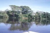
 High water season (Jan")
4 Flooding Low water season (Oct 1996) High water season (Jan 1990)

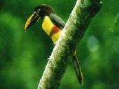
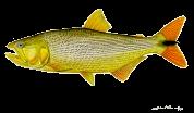


5 Biodiversity Plants 774 Aquatic macrophytes 155 Phytoplankton 690 Periphyton 824 Zooplankton (+ciliates+rotifers) 866 Benthic invertebrates (+Ostracods) 315 Ictioparasites 337 Fishes 170 Amphibian 22 Reptiles 37 Birds 295 Mammals 60 TOTAL 4545
6 Main Impacts Redistribution of the seasonal discharge promoted by dams provoked losses in floodable area and altered connectivity among the plain components PERMANENT DRY AREA DROUGHT FLOOD Natural discharges Regulateddischarges 16 Discharge(m 3/s.1,000) PERMANENT FLOODED AREA 8 6 JanFevMar Apr MayJun Jul AugSepOct NovDec LOSSES IN SEASONALLY INUNDABLE AREA Baran et al.(in prep)
 6 5 4 3")


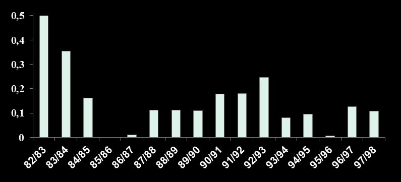
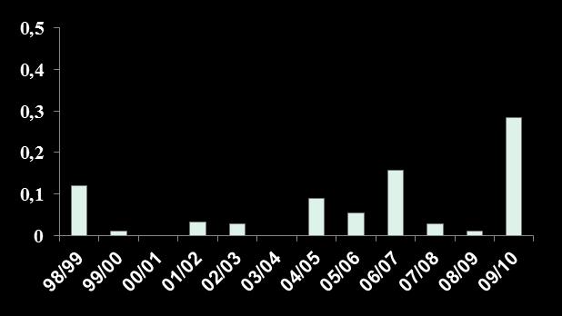
7 Increase in Secchi Depth due to sediment retention in reservoirs Secchi (m) Months a Roberto et al. (2009)


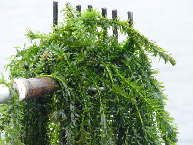
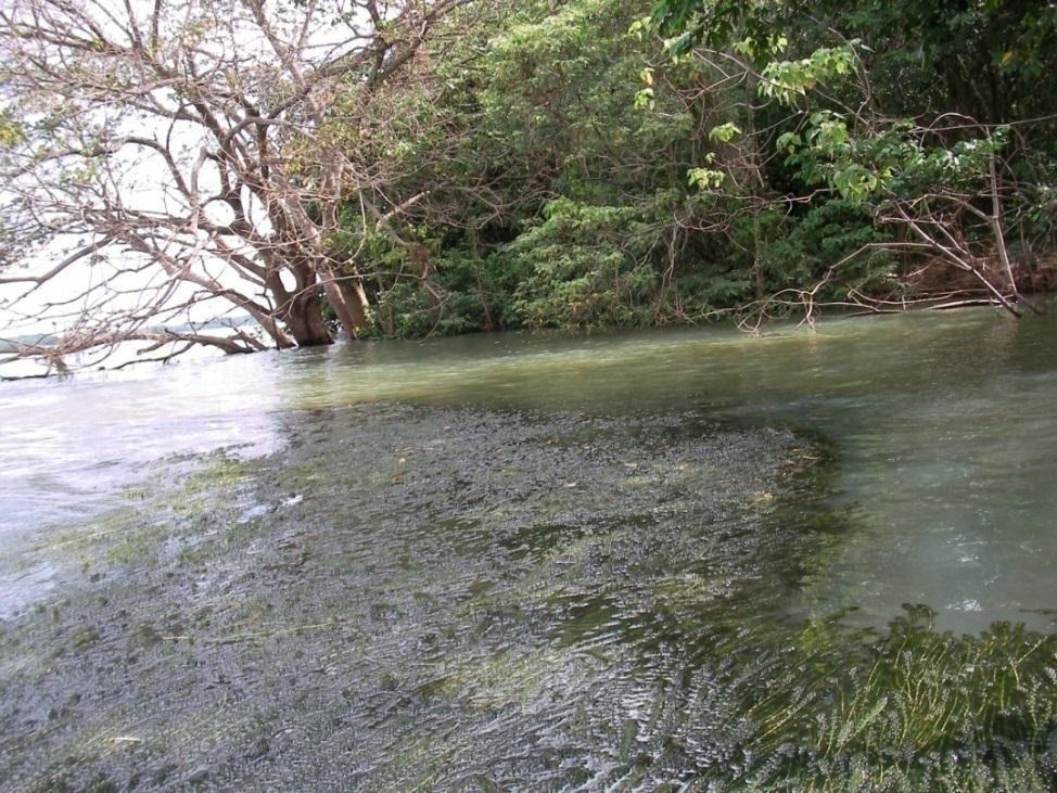
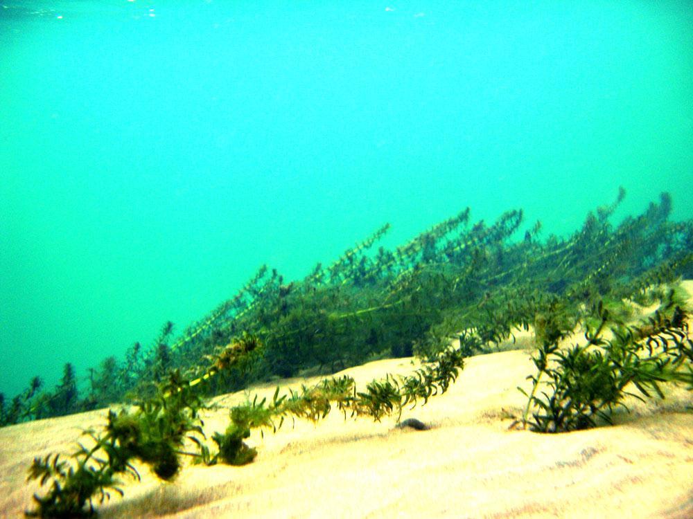
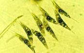
8 Habitat alterations Proliferation of submersed macrophytes Egeria densa Egeria najas Hydrilla verticillata By P. Mormul (UEM)


9 YEAR Habitat alterations Proliferation of non native species 4,0 3,5 3,0 2,5 2,0 1,5 1,0 0,5 Transparency (m) Paraná Baía Ivinheima 0, Years Closure of Porto Primavera Dam 3 PEACOCK BASS (% TOTAL) 2 1 PARANA BAIA IVINHEIMA
10 Total P ( L Nutrients retention by dams b Months Roberto et al. (2009)
11 Nutrient retention Roberto et al. (2009)


12 Daily water level Changes in Connectivity


")
13 Bank and island erosion High frequency pulses + sediment retention Erosion (piping) Sand-silt Clay
 =")
 = 18,200 m 3 /s 24/03/1985")


14 Changes in Riverbed overflow Discharge: Day (Mar 24, 1985) = 15,755 m 3 /s Maximum (Feb 17, 1985) = 18,200 m 3 /s 24/03/1985 Discharge: Day (Feb 23, 2007) = 18,733 m 3 /s Maximum (Feb 21, 2007) = 18,800 m 3 /s 23/02/2007 no overflow Conclusion: More water for the same flood

15 Water level x Connectivity WATER LEVEL Dec-2010 Dec-2009 Dec-2008 Dec-2007 Dec-2006 Dec-2005 Dec-2004 Dec-2003 Dec-2002 Dec-2001 Dec-2000 Dec-1999 Dec-1998 Dec-1997 Dec-1996 Dec-1995 Dec-1994 Dec-1993 Dec-1992 Dec-1991 Dec-1990 Dec-1989 Dec-1988 Dec-1987 Dec-1986 Dec-1985

16 Connectivity x Fish Recruitment
17 Flood attributes x Fish Recruitment YOUNG OF THE YEAR (cpue) YOUNG O FLOOD DURATION (days) GREATEST UNINTERRUPED OVERFLOW (days) YOUNG OF THE YEAR (cpue) YOUNG ,0 4,5 5,0 5,5 6,0 6,5 7,0 7,5 ANNUAL MAXIMUM LEVEL (m) 0 OCT NOV DEC JAN FEB MAR APR MAY JUN BEGINNING OF FLOOD (month)
 Suzuki et")
18 Flood intensity/duration and fish recruitment (ANCOVA outcomes) Suzuki et al. (2009)
19 Socioeconomic and cultural implication Reduction in fishery income Itaipu Reservoir (fishers come from other economic activity, of the which they were excluded) Upstream Itaipu Reservoir (traditional population) Illicit activity (smuggling, drug traffiking and transportation of stolen vehicles across the border between Brazil and Paraguay) Fishery abandonment (losses in lifestyle, knowledge, beliefs, feelings and social relationships) Increase in criminality Losses in cultural diversity
20 x Public polices for the region SOUTH AMERICA NOVA ANDRADINA MATO GROSSO DO SUL STATE BATAIPORÃ Regional Conservation Units 23º 00 54º 20 AMAMBAÍ GUIRAÍ VITÓRIA IVINHEIMA IVINHEIMA PARANÁ BAILE PATRÃO BAIA PARANÁ PORTO RICO XXX ROSANA PARANAPANEMA PORTO SÃO JOSÉ PARANÁ STATE PORTO PRIMAVERA PORTO CAIUÁ XXX IVAI MARACAÍ PORTO CAMARGO DO VEADO PIRAJUÍ MORUMBI IGUATEMI PARANÁ Ilha Grande PARANÁ PARACAI SÃO JOÃO L E G E N D SCALE 30 Km 40 ILHAS E VÁRZEA DO RIO PARANÁ PROTECTED AREA ILHA GRANDE NATIONAL PARK PARAGUAY BRAZIL GUAÍRA PIQUIRI RIO IVINHEIMA STATE PARK
21 Conclusions and Perspectives Impacts to floodplain stretches downstream of dams are related to loss of habitat and/or their deterioration (besides of blockage of fish migratory routes). This impact are caused by factors linked to the quality and quantity of water release along the year. Any action for mitigating the impacts should necessarily consider the manipulation of reservoir discharge, in order to meet habitat, biota, social, economic and cultural demands.

22
The Lower Prut Floodplain Natural Park (Romania)
") The Lower Prut Floodplain Natural Park (Romania) Gabriela Costea Natural Sciences Museum Complex Galati (Romania) & member of the Scientific Council of the Lower Prut Floodplain Natural Park The Prut The
The Lower Prut Floodplain Natural Park (Romania) Gabriela Costea Natural Sciences Museum Complex Galati (Romania) & member of the Scientific Council of the Lower Prut Floodplain Natural Park The Prut The
Are there successful fish passes? Lessons from South America. Paulo Santos Pompeu Federal University of Lavras
 Are there successful fish passes? Lessons from South America Paulo Santos Pompeu Federal University of Lavras Is it possible to build a successful fish pass? When it is not possible? Could we know when
January 2018 Air Traffic Activity Summary
 January 2018 Air Traffic Activity Summary Jan-2018 Jan-2017 CY-2018 CY-2017 Passengers 528,947 505,421 4.7% 528,947 505,421 4.7% Passengers 537,332 515,787 4.2% 537,332 515,787 4.2% Passengers 1,066,279
Water in the Amazon. By Heather and Georgie
 Water in the Amazon By Heather and Georgie The Amazon is the world s largest tropical rainforest. The Amazon is so big that the U.K and Ireland would fit into it 17 times. The Amazon River It s length
Environmental Issues in the la Plata Basin. Carlos E. M. Tucci and Robin T. Clarke. Institute of Hydraulic Research
 Environmental Issues in the la Plata Basin Carlos E. M. Tucci and Robin T. Clarke Institute of Hydraulic Research Federal University of Rio Grande do Sul Porto Alegre Brazil e-mail: Erro! A origem da referência
Environmental Impact Assessment in Chile, its application in the case of glaciers. Carlos Salazar Hydro21 Consultores Ltda.
 Environmental Impact Assessment in Chile, its application in the case of glaciers Carlos Salazar Hydro21 Consultores Ltda. carlos.salazar@hydro21.cl Introduction Changes in the environmental law in Chile
Assessing the Impacts of ENSO on South American Agriculture
 Assessing the Impacts of ENSO on South American Agriculture Mark Brusberg United States Department of Agriculture Office of the Chief Economist / Presented to: The International Symposium on Synergistic
Ecosystem context in the Environmental Impact Assessment of the Dredging Operations in the Argentina s Santa Fe
 Ecosystem context in the Environmental Impact Assessment of the Dredging g Operations in the Argentina s Santa Fe Confluencia Waterway (Paraná River) Authors: Claudio Daniele (Estudio de Ambiente y Desarrollo
Migratory Fishes. South America. Biology, Fisheries and Conservation Status. Edited by Joachim Carolsfeld Brian Harvey Carmen Ross Anton Baer
 Migratory Fishes of South America Biology, Fisheries and Conservation Status Edited by Joachim Carolsfeld Brian Harvey Carmen Ross Anton Baer Migratory Fishes of South America Migratory Fishes of South
PROJECT INFORMATION DOCUMENT (PID) CONCEPT STAGE Report No.: AB1412 Project Name
 CONCEPT STAGE Report No.: AB1412 Project Name") Public Disclosure Authorized Public Disclosure Authorized Public Disclosure Authorized Public Disclosure Authorized PROJECT INFORMATION DOCUMENT (PID) CONCEPT STAGE Report No.: AB1412 Project Name Paraguay
Public Disclosure Authorized Public Disclosure Authorized Public Disclosure Authorized Public Disclosure Authorized PROJECT INFORMATION DOCUMENT (PID) CONCEPT STAGE Report No.: AB1412 Project Name Paraguay
SAN ANTONIO RIVER IMPROVEMENTS PROJECT. April 27, 2009
 SAN ANTONIO RIVER IMPROVEMENTS PROJECT April 27, 2009 1 Project Limits 2 Project Partners City of San Antonio Provides project funding for project amenities (i.e.. Sidewalks, Landscaping, Lighting, etc.)
Case Study: 1. The Clarence River Catchment
 Case Study: 1. The Clarence River Catchment The NSW coastline is a great natural asset, making an enormous contribution to the economy. The resources of coastal catchments such as the Clarence River Catchment,
ROUGE RIVER REPORT CARD
 ROUGE RIVER REPORT CARD Noel Mullett, Wayne County Rouge River Report Card The Rouge River communities, residents and partners continue to address watershed issues Water quality and ecosystem health continues
I.G. MBAGW[J, B.M.B. LADU and A.O. AMADI' National Institute for Freshwater Fisheries Research (NIFFR) P.M B. 6006, New Bussa. Niger State, Nigeria
 P.M B. 6006, New Bussa. Niger State, Nigeria") CONTRIBUTIONS OF THE SEASONAL AND LONG TERM FLOOD PATTERNS OF RIVER NIGER TO THE DEVELOPMENT AND CONTROL OF WATER HYACINTH (Eiclthornia crassipes) IN KAINJI LAKE, NIGERIA I.G. MBAGW[J, B.M.B. LADU and
CONTRIBUTIONS OF THE SEASONAL AND LONG TERM FLOOD PATTERNS OF RIVER NIGER TO THE DEVELOPMENT AND CONTROL OF WATER HYACINTH (Eiclthornia crassipes) IN KAINJI LAKE, NIGERIA I.G. MBAGW[J, B.M.B. LADU and
RESPONSE OF RANDOMIZED SUBSETS OF RAINFALL GAUGES OVER A PARANÁ RIVER SUB-BASIN
 RESPONSE OF RANDOMIZED SUBSETS OF RAINFALL GAUGES OVER A PARANÁ RIVER SUB-BASIN Thais Fujita, A. P. Rudke, M. V. B. de Morais, S. A. A. Rafee, R. A. F. de Souza, R. V. A. de Souza, E. D. de Freitas, L.
Pantanal Forever Programme
 Pantanal Forever Programme The Pantanal Basin Upper Paraguay River Basin Bolivia + Paraguay + Brazil = 624.320 km2 Pantanal = 158.592 km2 Plateau = 465.728 km2 Cattle ranching and agriculture are the most
LESOTHO HIGHLANDS DEVELOPMENT AUTHORITY
 LESOTHO HIGHLANDS DEVELOPMENT AUTHORITY ANNUAL FLOW RELEASES INSTREAM FLOW REQUIREMENT (IFR) IMPLEMENTATION AND MONITORING (October 2004 to September 2005) TOWER ON MALIBAMATŠO RIVER @ KAO REPORT N0.6
SUPPORT TO WATER RESOURCES MANAGEMENT IN THE DRINA RIVER BASIN DRAFT ROOF REPORT INTRODUCTION AND GENERAL APPROACH
 SUPPORT TO WATER RESOURCES MANAGEMENT IN THE DRINA RIVER BASIN DRAFT ROOF REPORT INTRODUCTION AND GENERAL APPROACH Nadja Zeleznik, REC Public Concultation Beograd, Serbia, 4 July 2017 1 1. Introduction
The Vjosa River in Albania
 The Vjosa River in Albania Europe s Wild jewel - beautiful, unknown and threatened The extensive braided river section near Tepelena would drown in a reservoir of the future Kalivaç dam. (Romy Durst) Major
Carbon Neutralization
 Carbon Neutral Carbon Neutralization September/2008 The Instituto H&H Fauser (H & H Fauser Institute) is a non-governmental organization that has for purpose the promotion of the sustainable development,
Join the Houston Zoo for a very special trip: Brazil s Pantanal: South America s Savannah. July 21 to July 29, 2018
 Join the Houston Zoo for a very special trip: Brazil s Pantanal: South America s Savannah July 21 to July 29, 2018 US $7,999 per person (double occupancy) US $1,000 single supplement The Pantanal is the
Environmental Impact Assessment of the dredging operations and aids to navigation works in the Argentina s Santa Fe Confluencia waterway.
 of the dredging operations and aids to navigation works in the Argentina s Santa Fe Confluencia waterway. LIC. CLAUDIO DANIELE cdaniele@estudioayd.com.ar Presented by Ing. Martín Civeira Study area Argentina
Phoenix Habitat Restoration Projects
 Phoenix Habitat Restoration Projects Spur Cross Ranch Cave Creek (Estergard) Regional Tree and Shade Summit March 9, 2010 Desert Riparian Ecosystems Healthy riparian areas like this once existed along
LESOTHO HIGHLANDS DEVELOPMENT AUTHORITY
 LESOTHO HIGHLANDS DEVELOPMENT AUTHORITY ANNUAL FLOW RELEASES INSTREAM FLOW REQUIREMENT (IFR) IMPLEMENTATION AND MONITORING (October 2005 to September 2006) REPORT N0.7 OCTOBER 2007 STRATEGIC AND CORPORATE
URBAN FLOODS IN SOUTH AMERICA
 URBAN FLOODS IN SOUTH AMERICA Dr. Carlos E.M. Tucci IPH Institute of Hydraulic Research SAMTAC/GWP Pantanal during wet season CONTENTS Urban development Floods types Issues on urban drainage floods Issues
Global importance of the La Plata River Basin
 CONFRONTING THE CHALLENGES OF CLIMATE VARIABILITY AND CHANGE THROUGH AN INTEGRATED STRATEGY FOR THE SUSTAINABLE MANAGEMENT OF THE LA PLATA RIVER BASIN (LPB) 1 Global importance of the La Plata River Basin
Europe s wild jewel - The Vjosa River in Albania
 SAVE THE BLUE HEART OF EUROPE THE BALKAN RIVERS Europe s wild jewel - The Vjosa River in Albania BEAUTIFUL, UNKNOWN AND THREATENED The extensive braided river section near Tepelena would drown in a reservoir
Geoscape Toronto The Oak Ridges Moraine Activity 2 - Page 1 of 10 Information Bulletin
 About 13,000 years ago as the Laurentide Ice Sheet melted, glacial meltwater accumulated between the ice sheet and the Niagara Escarpment. This formed a lake basin into which gravel and sand were deposited.
André Dib/WWF-Brasil PANTANAL 2018
 André Dib/WWF-Brasil PANTANAL 2018 Diamantino jornadadaagua.org fb.com/wwfbrasil Alto Paraguay APA Nascentes do rio Paraguay tamanduá-bandeira Ipê Chapada dos Guimarães Buriti Cuiabá foz do Rio Sepotuba
Macmillan Cultural Readers ELEMENTARY LEVEL. Brazil MACMILLAN
 Macmillan Cultural Readers ELEMENTARY LEVEL SUSAN HOLDEN AND Alberta White Brazil MACMILLAN Macmillan Cultural Readers ELEMENTARY LEVEL Founding Editor of the Macmillan Readers: John Milne The Macmillan
*Latin America spans 7,000 miles, from Mexico to Tierra Del Fuego. *3 Regions: Central America, South America, and the Caribbean.
 Physical Geography Latin America spans 7,000 miles, from Mexico to Tierra Del Fuego *3 Regions: Central America, South America, and the Caribbean. *Intro clip: http://www.youtube.com/watch?v=cffp6rza3
21 WORLD CONGRESS OF SOIL SCIENCE August 12-17, 2018 Rio de Janeiro, Brazil
 21 WORLD CONGRESS OF SOIL SCIENCE August 12-17, 2018 Rio de Janeiro, Brazil E5 - FIELD TRIP TO PRODUCTION SYSTEMS AND THE INTERACTION WITH SOIL AND ENVIRONMENT IN PARANÁ STATE Summary: The 5-day tour will
BEFORE PROJECT THE BEGINNING
 BEFORE PROJECT THE BEGINNING SWBNP is a final sample of the former Lakes of Danube. On an area of 241 km2, PN-BmB retain 10% of the former Inland River Delta, the former Lake of Brăila and Ialomiţei, who
SMALL WETLAND OF BRĂILA MANAGEMENT PLAN
 SMALL WETLAND OF BRĂILA MANAGEMENT PLAN HG no. 538 / 18 Maz 2011 Oficial Monitor 498 / 13 July 2011 Radu MOISEI Ph.D Small Wetland of Brăila localisation Small Wetland of Brăila occupies a stretch of 62
WALKER SWAMP INFORMATION DAY Saturday 23 rd June 2018
 WALKER SWAMP INFORMATION DAY Saturday 23 rd June 2018 Introduction to the Upper Wannon River Floodplain wetlands and the new Walker Swamp Restoration Reserve Mark Bachmann and Greg Kerr, Nature Glenelg
Paul Sturm Roberto Viqueira Ríos
 Paul Sturm Roberto Viqueira Ríos In this talk Brief Background on Land Based Sources Historical Perspective Guánica watershed characteristics/ issues High priority restoration projects Other key issues
SAN ANTONIO RIVER IMPROVEMENTS PROJECT. August 6, 2008
 SAN ANTONIO RIVER IMPROVEMENTS PROJECT August 6, 2008 1 History of the SA River Improvements 1921 Flood Olmos Dam Complete in 1929 Downtown Flood Relief Projects in 1950 s Dams on the River Channel and
SUMMER COURSE Innovation in Tourism and Sustainable Regional Development AZORES - Portugal, 3-10 September 2011
 SUMMER COURSE Innovation in Tourism and Sustainable Regional Development AZORES - Portugal, 3-10 September 2011 Crisis and Ruptures, Tourism as a Lever of Regional Development Tomaz Ponce Dentinho Universidade
Hydrology Input for West Souris River IWMP
 Hydrology Input for West Souris River IWMP Prepared by: Mark Lee Manitoba Water Stewardship 1 1 1 Overall view of: drainage area watershed characteristics gauging stations meteorological stations Runoff
Regional impacts and vulnerability mountain areas
 Regional impacts and vulnerability mountain areas 1 st EIONET workshop on climate change vulnerability, impacts and adaptation EEA, Copenhagen, 27-28 Nov 2007 Klaus Radunsky 28 Nov 2007 slide 1 Overview
Congo names four large Ramsar sites
 Congo names four large Ramsar sites 1 February 2008 Congo The Republic of Congo designates four sites on World Wetlands Day 2008 The Direction Générale de l'environnement of the Republic of Congo has taken
Alaskan/Fjordland Pacific (Ecoregion 22)
") Alaskan/Fjordland Pacific (Ecoregion 22) Background The Alaskan/Fjordland Pacific Ecoregion is an area of abundant marine resources. The ecoregion begins at Vancouver Island and moves up the Gulf of Alaska
Alaskan/Fjordland Pacific (Ecoregion 22) Background The Alaskan/Fjordland Pacific Ecoregion is an area of abundant marine resources. The ecoregion begins at Vancouver Island and moves up the Gulf of Alaska
2014 Colorado River Annual Operating Plan Colorado River Management Work Group (CRMWG) Final Consultation September 5, 2013
 Final Consultation September 5, 2013") 2014 Colorado River Annual Operating Plan Colorado River Management Work Group (CRMWG) Final Consultation September 5, 2013 2014 Colorado River AOP Final Consultation Meeting Welcome and Introductions
2014 Colorado River Annual Operating Plan Colorado River Management Work Group (CRMWG) Final Consultation September 5, 2013 2014 Colorado River AOP Final Consultation Meeting Welcome and Introductions
Damn those dams their effects on stream ecosystems
 Damn those dams their effects on stream ecosystems Jeremy Tiemann Illinois Natural History Survey Prairie Research Institute at the University of Illinois History of dams History of dams First evidence
30 November Randall G. Hintz Chief, Operations Support Branch Operations Division. US Army Corps of Engineers BUILDING STRONG
 30 November 2011 Randall G. Hintz Chief, Operations Support Branch Operations Division US Army Corps of Engineers Overview MAINTENANCE PROJECTS Deep Draft Channels Shallow Draft Channels Coastal Inlets
Insights in the water-energy-food nexus in the Nile Basin with the new Eastern Nile Water Simulation Model
 Insights in the water-energy-food nexus in the Nile Basin with the new Eastern Nile Water Simulation Model Wil N.M. van der Krogt, Henk J.M. Ogink For International Conference Sustainability in the WaterEnergy-Food
Thailand 12. Pasak River. Map of River
 Pasak River Map of River 232 Table of Basic Data Name: Pasak river Serial No. : Thailand-12 Location: Central part of Thailand N 14 21' 44" ~ 17 06' 02" E 100 34' 40" ~ 101 32' 56" Area: 15,779 km 2 Length
Use of Wetlands for Sustainable Tourism Management
 Use of Wetlands for Sustainable Tourism Management Christine Lim a and Michael McAleer b a School of Tourism and Hotel Management, Griffith University (christine.lim@mailbox.gu.edu.au) b Department of
Depec-Bradesco Economic Highlights
 Depec-Bradesco Economic Highlights Year XII Number 129 - December, 23 2015 Differences in regional inflation dynamics are explained by behavior of food, service and regulated prices Myriã Tatiany Neves
HOTEL INDUSTRY OVERVIEW. Texas
 HOTEL INDUSTRY OVERVIEW Texas DEMAND GROWTH STRONG BALANCED OCC & ADR GROWTH % Change Room Supply* 149M 1.3% Room Demand* 92M 5.6% Occupancy 61.6% 4.3% A.D.R. $90 4.4% RevPAR $55 8.9% Room Revenue* $8.3B
Cau River. Map of River. Table of Basic Data. Vietnam 5
 Cau River Map of River Table of Basic Data Name: Cau River Location: Thai Nguyen, Province, Viet Nam Area: 6,030 km 2 Origin: Mt. Phia Deng 1,527 m Outlet: Pha Lai Note: * Indicates missing data in some
Interested in learning more? Global Information Assurance Certification Paper. Copyright SANS Institute Author Retains Full Rights
 Global Information Assurance Certification Paper Copyright SANS Institute Author Retains Full Rights This paper is taken from the GIAC directory of certified professionals. Reposting is not permited without
A pilot flood retention area in La Bassée
 A pilot flood retention area in La Bassée Institution interdépartementale des barrages-réservoirs du bassin de la Seine 8, rue Villiot - 75012 Paris - Tél. : 01 44 75 29 29 - Télécopie : 01 44 75 29 30
PRESPA BIOSPHERE RESERVE MANAGEMENT MACEDONIAN PERSPECTIVE
 PRESPA BIOSPHERE RESERVE MANAGEMENT MACEDONIAN PERSPECTIVE Secretariat by Ohrid, 10.03.2016 Prespa Ohid TBB reserve Biodiversity richness trans-boundary level Total Species richness Registered over 1500
Wetlands influencing river biogeochemistry: the case study of the Zambezi and the Kafue Rivers
 AFRIVAL Project (African River Basins) http://ees.kuleuven.be/project/afrival/ EGU General Assembly 2014, Vienna Wetlands influencing river biogeochemistry: the case study of the Zambezi and the Kafue
DIDYMO SURVEY, LOWER FRYINGPAN RIVER, BASALT, COLORADO 2015
 DIDYMO SURVEY, LOWER FRYINGPAN RIVER, BASALT, COLORADO 2015 Second Annual Report PREPARED FOR: ROARING FORK CONSERVANCY PREPARED BY: COLORADO MOUNTAIN COLLEGE NATURAL RESOURCE MANAGEMENT PROGRAM TIMBERLINE
Ocho Rios, Jamaica GEF-IWCAM AND IABIN INDICATORS MECHANISM WORKSHOP March TNC s Marine Protected Area Work.
 TNC s Marine Protected Area Work in the Caribbean GEF-IWCAM AND IABIN INDICATORS MECHANISM WORKSHOP 10-12 March 2008 Ocho Rios, Jamaica Caribbean Decision-Support System 3 years (2003-2006) $2.2 million
Ecologia del Paesaggio e Biodiversità Capitolo 1
 System changes in the Pantanal (Brazil): lessons for wetland management Rob H.G Jongman Alterra, Wageningen University and Research Centre, P.O. Box 47, 6700 AA Wageningen, the Netherlands Abstract The
Title/Name of the area: Chwaka Bay, Zanzibar
 Title/Name of the area: Chwaka Bay, Zanzibar Presented by: Dr. Charles Lugomela, Ag. Head, Department of Aquatic Sciences and Fisheries, University of Dar es Salaam, P.O. Box 35064 Dar es Salaam, Tanzania
MODEL Task Team. NEMURO NEMURO.FISH Dynamic link Coupled with population dynamics model PEST Regional comparison 3D-NEMURO
 MODEL Task Team NEMURO NEMURO.FISH Dynamic link Coupled with population dynamics model PEST Regional comparison E-NEMURO 3D-NEMURO ECOPATH/ECOSIM+NEMURO Ecological Modelling special volume Future perspectives
Infrastructure Developments in Brazil s Northern Arc
 THIS REPORT CONTAINS ASSESSMENTS OF COMMODITY AND TRADE ISSUES MADE BY USDA STAFF AND NOT NECESSARILY STATEMENTS OF OFFICIAL U.S. GOVERNMENT POLICY Voluntary - Public Date: 9/20/2017 GAIN Report Number:
Spatial Distribution and Characteristics of At-Risk Species in the Southeast U.S.
 Nicholas Institute for Environmental Policy Solutions Scoping Document Part 2 Exploratory Analysis of Characteristics and Trends of At-Risk Species in the Southeast U.S. Spatial Distribution and Characteristics
WHERE WE ARE NUMBERS OF CEMIG NUMBERS OF CEMIG NUMBERS OF MINAS GERAIS NUMBERS OF CEMIG. Brazil. Minas Gerais
 WHERE WE ARE Brazil Minas Gerais The Sate of Minas Gerais is the third economic force in Brazil NUMBERS OF MINAS GERAIS NUMBERS OF CEMIG Inhabitants 18,900,000 Area 588,400 km 2 Capital Belo Horizonte
Jeneberang River. Serial No. : Indonesia-10 Location: South Sulawesi Area: 727 km 2 Origin: Mt. Bawakaraeng (2,833 MSL) Outlet: Makassar Strait
 Outlet: Makassar Strait") Jeneberang River Map of River Table of Basic Data Name: Jeneberang River Serial No. : Indonesia-10 Location: South Sulawesi S 5 10' 00" - 5 26' 00" E 119 23' 50" - 119 56' 10" Area: 727 km 2 Origin: Mt.
Jeneberang River Map of River Table of Basic Data Name: Jeneberang River Serial No. : Indonesia-10 Location: South Sulawesi S 5 10' 00" - 5 26' 00" E 119 23' 50" - 119 56' 10" Area: 727 km 2 Origin: Mt.
DASHBOARD DEC YOUR MONTHLY UPDATE FOR IOWA ONE CALL
 Executive Summary Per the Board s request, we have added this Executive Summary to the Monthly Dashboard. We ll be including it from now on. It will provide you with a running total of the number of tickets
IMPACTS OF THE RECENT TSUNAMI ON THE BUNDALA NATIONAL PARK THE FIRST RAMSAR WETLAND IN SRI LANKA
 IMPACTS OF THE RECENT TSUNAMI ON THE BUNDALA NATIONAL PARK THE FIRST RAMSAR WETLAND IN SRI LANKA by C.N.B. Bambaradeniya, IUCN The World Conservation Union, Sri Lanka Country Office (Email: cnb@iucnsl.org)
Wetlands Reservoirs of Biodiversity. Billy McCord, SCDNR
 Wetlands Reservoirs of Biodiversity Billy McCord, SCDNR Estuaries Tidal Deepwater Intertidal Salt Marsh Tidal Riverine Fresh & Brackish Deepwater Tidal Emergent Marsh Freshwater Riverine Seasonally Flooded
HYDRAULIC DESIGN OF THE TOURISTIC BERTHING IN ASWAN CITY
 HYDRAULIC DESIGN OF THE TOURISTIC BERTHING IN ASWAN CITY Dr. Hossam El-Sersawy Researcher, Nile Research Institute (NRI), National Water Research Center (NWRC), Egypt E-mail: h_sersawy@hotmail.com Dr.
Virginian Atlantic (Ecoregion 8)
") Virginian Atlantic (Ecoregion 8) Background The Virginian Atlantic Ecoregion extends from the south side of Cape Cod to Cape Hatteras in North Carolina. The waters of the ecoregion are a mix of cold and
Virginian Atlantic (Ecoregion 8) Background The Virginian Atlantic Ecoregion extends from the south side of Cape Cod to Cape Hatteras in North Carolina. The waters of the ecoregion are a mix of cold and
Human impacts on hydrology in the Pantanal wetland of South America
 Human impacts on hydrology in the Pantanal wetland of South America W.K. Kellogg Biological Station and Department of Zoology, Michigan State University, Hickory Corners, MI 49060-9516, USA (E-mail: hamilton@kbs.msu.edu)
2.1 Physical and Biological Description Matabitchuan River Watershed
 2.1 Physical and Biological Description Watershed 2.1.1 Physical Description The system watershed has a total area of about 933 km 2 and is a tributary system to Lake Temiskaming and the Ottawa River Drainage
Lake Chelan Operations
 Lake Chelan Operations IPMA Executive Seminar September 17, 2013 Presented by: Janet Jaspers Chelan County PUD Lake Chelan Hydroelectric Project Today s Discussion Chelan PUD Overview Interesting Facts
DTTAS Quarterly Aviation Statistics Snapshot Quarter Report
 Contents DTTAS Quarterly Aviation Statistics Snapshot Quarter 4 2015 Report 1.1 Dublin Airport Key Statistics... 1 1.2 Cork Airport Key Statistics... 3 1.3 Shannon Airport Key Statistics... 5 1.4 Total
DTTAS Quarterly Aviation Statistics Snapshot Quarter Report
 Contents DTTAS Quarterly Aviation Statistics Snapshot Quarter 3 2018 Report 1.1 Dublin Airport Key Statistics... 1 1.2 Cork Airport Key Statistics... 3 1.3 Shannon Airport Key Statistics... 5 1.4 Total
DTTAS Quarterly Aviation Statistics Snapshot Quarter Report
 Contents DTTAS Quarterly Aviation Statistics Snapshot Quarter 1 2018 Report 1.1 Dublin Airport Key Statistics... 1 1.2 Cork Airport Key Statistics... 3 1.3 Shannon Airport Key Statistics... 5 1.4 Total
-Dr Panambi Abadie Executive Secretary, AUGM
 Workshop 3: Perceptions of the Erasmus Mundus programme in third-countries. -Dr Panambi Abadie Executive Secretary, AUGM EM-iDEA Conference, Ghent 23/11/2011 1 PERSPECTIVES OF AUGM ON THE EM PROGRAMME
Opioid Surveillance Jun 2017
 Opioid Surveillance Jun 217 Medical Examiner Source: Ingham County Medical Examiner Data is current as of Jun 13, 217 22 total drug-related Ingham resident deaths occurred in Ingham County 17 deaths were
Considerations for the Long-Term Atmospheric Observing Network
 Considerations for the Long-Term Atmospheric Observing Network 1. Land Cover / Land Use & Change 2. Spatial & temporal scale of climate anomalies 3. Climatological wind patterns 4. Expected signals vs.
ANALYSIS OF INADEAUTE WATER QUALITY OD THE RESERVOIR VONARJE/SUTLA LAKE AND POSSIBILITY OF RESTORATION AND UTILIZATION
 EC project on Integration of Natural Water Retention Measures in river basin management The 1 st Danube Region Workshop ANALYSIS OF INADEAUTE WATER QUALITY OD THE RESERVOIR VONARJE/SUTLA LAKE AND POSSIBILITY
What insight does monitoring of arboreal marsupials offer for mitigating road impacts on wildlife?
 What insight does monitoring of arboreal marsupials offer for mitigating road impacts on wildlife? Dr Ross Goldingay Wildlife Ecology Program Southern Cross University Lismore, NSW Photo: Karawatha Preservation
Terrestrial Protected Area Nomination: Central Mangrove Wetland South-West, Grand Cayman
 Terrestrial Protected Area Nomination: Central Mangrove Wetland South-West, Grand Cayman The attached nomination, proposing that a parcel of land in the Central Mangrove Wetland be made a Protected Area
Cat Island Chain Background & Access Guide
 Cat Chain Background & Access Guide Brown County Port & Resource Recovery Department 2561 S. Broadway, Green Bay, WI 54304 (920) 492-4950 www.portofgreenbay.com January 2018 1 Restoration of the Cat Chain
Interested in learning more? Global Information Assurance Certification Paper. Copyright SANS Institute Author Retains Full Rights
 Global Information Assurance Certification Paper Copyright SANS Institute Author Retains Full Rights This paper is taken from the GIAC directory of certified professionals. Reposting is not permited without
We drum out your future!
 BONUS: Once you ve qualified and registered as a Tourist Guide we ll place your details on our website for Tour Operators to find you! Mahala! Gratis! For Free! FULL WEEK TRAINING DATES CULTURE 2019 Course
1 What do you know about Brazil? What. 2 What would you like to know about Brazil? 3 Look at the short movie clips below to see
 This fact sheet introduces you to the beautiful country of Brazil with its varied scenery. 1 What do you know about Brazil? What is Brazil famous for? Make a list of the facts that you know about the country
Submission on the Tukituki Catchment Proposal: EPA reference numbers; NSP 13/ , NSP 13/ , NSP 13/ , NSP 13/02.
 Hutt Valley Tramping Club PO Box 30 883 LOWER HUTT 5045 Tukituki Catchment Proposal Environmental Protection Agency Private Bag 63 002 WELLINGTON 6140 29 July 2013 Submission on the Tukituki Catchment
Summer Work Travel Season Program Dates by Country
 Albania 1-Jul 30-Sep 3 Months Argentina 1-Dec 1-Apr 4 Months Armenia 1-Jun 31-Aug 3 Months Australia 15-Nov 8-Mar 3.5 Months Visa Waiver Country Austria 1-Jul 30-Sep 3 Months Visa Waiver Country Azerbaijan
ANGUILLA TOURISM HIGHLIGHTS FOR 2006 VISITOR ARRIVALS 72, % 60.1% Same Day Visitors 94,283. Tourist Arrivals I ( Winter ( Summer
 ANGUILLA TOURISM HIGHLIGHTS FOR 2006 VISITOR ARRIVALS Tourist Arrivals I ( Winter ( Summer 72,962 39.9% 60.1% Same Day Visitors 94,283 VISITOR PROFILE Average Length of Stay (nights) I 8.0 Tourist Arrivals
Airport Capacity, Airport Delay, and Airline Service Supply: The Case of DFW
 Airport Capacity, Airport Delay, and Airline Service Supply: The Case of DFW Faculty and Staff: D. Gillen, M. Hansen, A. Kanafani, J. Tsao Visiting Scholar: G. Nero and Students: S. A. Huang and W. Wei
Chuckanut Ridge Fairhaven Highlands EIS Scoping Concerns
 Chuckanut Ridge Fairhaven Highlands EIS Scoping Concerns Coalition of Southside Neighborhoods CSN Comments for Fairhaven Highlands EIS Scope Hearing, Jan 16, 2008 1 Chuckanut Ridge Hilly Terrain: Potential
Public Lands in Alaska. 200 million acres of federal land - Over 57 Million acres of Wilderness more than half the Wilderness in the entire nation
 Public Lands in Alaska 200 million acres of federal land - Over 57 Million acres of Wilderness more than half the Wilderness in the entire nation alaskawild.org Ground Zero for Climate Change Over the
Appendix A: San Francisco River Photos Gila National Forest
 Appendix A: San Francisco River Photos Gila National Forest These photos accompany our request for closure to demonstrate both the the outstanding ecological values associated with this area, as well as
Norfolk District North Atlantic Division
 Norfolk District North Atlantic Division Eastern Chapter of WEDA Fall Conference October 26, 2016 Stephen J. Powell, P.E. (757) 201-7788 US Army Corps of Engineers Norfolk District FY-17 Dredging Program
ICELANDAIR NICE-REYKJAVIK SURVEY. OPPORTUNITIES SURVEY SOUTH & CENTRAL AMERICA / CARRIBEAN FROM/TO NICE AIRPORT Routes Online 2012
 ICELANDAIR NICE-REYKJAVIK SURVEY OPPORTUNITIES SURVEY SOUTH & CENTRAL AMERICA / CARRIBEAN FROM/TO NICE AIRPORT Routes Online 2012 1 NICESOUTH & CENTR.AM / CARRIBEAN 2 - South & Central Amer. / Carribean
Jamaica Member Report
 National Environment and Jamaica Member Report International Coral Reef Initiative 28 th General Meeting October 14-17, 2013 Belize City, Belize Loúreene Jones Coastal and Marine Resources Beaches Wetlands
LOVE FIELD ENVIRONMENTAL ADVISORY COMMITTEE QUARTERLY REPORT. October December 2016
 LOVE FIELD ENVIRONMENTAL ADVISORY COMMITTEE QUARTERLY REPORT October December 2016 VOLUNTARY NOISE CONTROL PROGRAM COMPLIANCE DURING PREFERENTIAL HOURS 2100 0600 (JAN SEP 2016) 2 PERCENTAGE OF COMPLIANCE
National and Regional Activities, Needs and Expectations
 National and Regional Activities, Needs and Expectations The perspective from the International Sava River Basin Commission International collaboration in the forecasting of river flows within the Sava
KASKASKIA RIVER NAVIGATION POOL Compartment 12 UNIT 1 Kaskaskia Lock and Dam Lands These lands are now being managed by the Carlyle Lake project
 KASKASKIA RIVER NAVIGATION POOL Compartment 12 UNIT 1 Kaskaskia Lock and Dam Lands These lands are now being managed by the Carlyle Lake project office. Sections 1-4 in this plan present Kaskaskia River
4/28/17. Clicker Question. Clicker Question. #37 Floods IV (Case Histories-Mississippi River Flood, 1993; Red River of North Flood, 1997)
") GEOL 118 Final Exam Format similar to exams 1 and 2 Covers Lectures #27 40 (Global Climate Change I - Meteorite Impacts III) Web Exercise #6 - Due by 1 pm, Monday (5/1) 8:00 AM, Thursday, May 11 th Location
GEOL 118 Final Exam Format similar to exams 1 and 2 Covers Lectures #27 40 (Global Climate Change I - Meteorite Impacts III) Web Exercise #6 - Due by 1 pm, Monday (5/1) 8:00 AM, Thursday, May 11 th Location
FMB. Latin America Market Outlook Fertilizer Outlook and Technology Conference. Market Reporting Consulting Events
 Latin America Market Outlook Fertilizer Outlook and Technology Conference Blake Hurtik, Editor 15 November 2016 FMB London Houston Singapore Moscow Dubai New York Portland Calgary Santiago Bogota Rio de