La biodiversidad de Ecuador. Dan Cogalniceanu
|
|
|
- Sophie Benson
- 6 years ago
- Views:
Transcription
1 La biodiversidad de Ecuador Dan Cogalniceanu

2 Contenido Ecuador como hotspot Caracteristicas biogeograficas Riqueza especifica de anfibios Investigacion en bosque nublado Comparacion Ecuador-Rumania

3 ECUADOR Total area Highest peak Coastline 283,561 km² 6268 m 2237 km

4 COSTA SIERRA ORIENTE Major geographic divisions of Ecuador
5 Defining Biodiversity Hotspots Myers Hotspots: Earth s Biologically Richest and Most Endangered Terrestrial Ecoregions (1999) Defined as "a biogeographic region with a significant reservoir of biodiversity that is threatened with destruction. Twenty-four areas are identified that support nearly 60% of the world's plant, bird, mammal, reptile, and amphibian species. Half of the world s plant species and 42 percent of all terrestrial vertebrate species are endemic to hotspots. Cover only 2.3 percent of the Earth's land surface.


6 Myers et al Biodiversity Hotspots

7

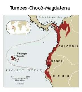
8 South America 1. Atlantic Forest 2. Cerrado 3. Chilean Winter Rainfall- Valdivian Forests 4. Tumbes-Chocó-Magdalena 5. Tropical Andes

9
, and deforestation, especially mangroves.")
10 Tumbes-Chocó-Magdalena Bordered by Mesoamerica in the north, and to the east the Tropical Andes hotspots. Main threats include: urbanization, hunting (large birds and mammals), and deforestation, especially mangroves. Ecuador's coastal forests are only 2 percent of their original area consequently species presence continue to decline.
11 Tumbes-Chocó-Magdalena Hotspot Original Extent (km 2 ) 274,597 Hotspot Vegetation Remaining (km 2 ) 65,903 (24%) Endemic Plant Species 2,750 Endemic Threatened Birds 21 Endemic Threatened Mammals 7 Endemic Threatened Amphibians 8 Extinct Species 4 Human Population Density (people/km 2 ) 51 Area Protected (km 2 ) 34,338

12 Tropical Andes Greatest biodiversity on Earth Contain about 1/6 of all plant spp. in <1% of earth's surface Species with unusual life histories e.g. Andean bromeliad 100 yrs to mature. Highest amphibian diversity in the world, also highest proportion of endangered species. Threats include: mining, timber extraction, oil exploration, and narcotics plantations, hydroelectric dams, cattle ranching and invasive species.
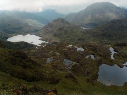
13 Tropical Andes Hotspot Original Extent (km 2 ) 1,542,644 Hotspot Vegetation Remaining (km 2 ) 385,661 (25%) Endemic Plant Species 15,000 Endemic Threatened Birds 110 Endemic Threatened Mammals 14 Endemic Threatened Amphibians 363 Extinct Species 2 Human Population Density (people/km 2 ) 37 Area Protected (km 2 ) 246,871
 Global Conservation Significance of Ecuador's Yasuní National Park. PLoS ONE 5(1): e8767.")
14 Species richness patterns of northern South America Bass MS, Finer M, Jenkins CN, Kreft H, et al. (2010) Global Conservation Significance of Ecuador's Yasuní National Park. PLoS ONE 5(1): e8767.
 Global Conservation Significance of Ecuador's Yasuní National Park.")
15 Richness center overlap Bass MS, Finer M, Jenkins CN, Kreft H, et al. (2010) Global Conservation Significance of Ecuador's Yasuní National Park. PLoS ONE 5(1): e8767.


16 Profiles of western Ecuador Lynch and Duelmann, 1997


17 Ecosystem diversity in southern Ecuador


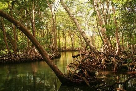
18 Mangrove forest, Island of Jambeli, El Oro Province

 100 80 60 40 20 0 1 2 3")

19 Average mean values Mean precipit. (mm) Average mean temp. ( C) Months Dry Forest, Reserva Arenillas, El Oro


20 Cloud Forest, Buenaventura, El Oro Province

21 Paramo, Loja Province
22 Habitat types with elevation along tropical altitudinal gradients in the Andes Navas, 2002
23 Classification of bioclimatic regimes (ecological zones) of Ecuador (Cañadas, 1983) Main ecosystem types Temperature ( 0 C) Páramo 0-6 Humid Very humid Subtemperate Rainfall (mm/year) < Rainy Very rainy 6-12 Subhumid Humid Very humid Rainy Very rainy >3000 Pluvial Temperate Dry Subhumid Humid Very humid Rainy Very rainy Subtropical Very dry Dry Subhumid Humid Very humid Rainy Tropical Desert Subdesert Very dry Dry Subhumid Humid Very humid

24 Major climate zones

25 91 ecosystem types Litoral: 24 Andes : 45 Amazonia: 22 Forested areas 42% of the area

26 Forest types


27 Network of national protected areas of Ecuador Does not include private protected areas. Covers 19%


28 Privately own reserves by Jocotoco and EcoMinga


29 Conflicts and overlapping área Areas Protegidas Yacimientos Petróleo Yacimientos Mineros Territorios Indígenas

30
31 The countries with the highest amphibian species number worldwide

32 Country Amphibian species richness Area (km 2 ) Species density (number species/10,000 km 2 ) 1 Brasil ,514, Colombia 773 1,141, Peru 574 1,285, Ecuador , according to Amphibiaweb.org 576 according to AmphibiaWeb Ecuador Amphibian species described in the last six years in the four countries with the greatest richness of amphibians in the neotropics.
33 The countries with the highest density of amphibian species worldwide
34 New species of amphibians described during (AmphibiaWeb.org) 2000 World, n=1924 Cummulative number of species Year Ecuador, n=97


35 576 amphibians in Ecuador 545 species of Anura 22 species of Caecilia 9 species of Urodela
36 Number of species Endemics Amphibian species richness Ecuador Anura Caudata Gymnophiona Endemics Nonendemics Total Anura Caudata Gymnophiona Total 239 (41.5%)
37 Typhlonectidae Siphonopidae Rhinatrematidae Endemic Non-endemic Caeciliidae Plethodontidae Telmatobiidae Ranidae Pipidae Microhylidae Leptodactylidae Hylidae Hemiphractidae Eleutherodactylidae Dendrobatidae Craugastoridae Ceratophryidae Centrolenidae Bufonidae Aromobatidae Number of species

38 The genus Pristimantis has the highest number of species among terrestrial vertebrates Ecuador has 194 species of Pristimantis out of the 576 known species (>30%).
39 140 Cummulative number of new species New species of Pristimantis New species of Pristimantis in Ecuador N=121 N= Year

40 Numbers of species of the family Craugastoridae (former Eleutherodactylus) at 100m increments on the Pacific lowlands and western slopes of the Andes in Ecuador.

41 Main biogeographic regions
42 Number of amphibian species Annual rainfall (mm)
43 Number of amphibian species Average annual temperature ( 0 C)
44
45


46 Reserva Buenaventura Fundación Jocotoco

47 Family Species list Present study Bufonidae Rhinella marina x x x Centrolenidae Espadarana prosoblepon x x Centrolenidae Nymphargus orense sp. nov. x Centrolenidae Nymphargus buenaventura x x Dendrobatidae Epipedobates anthonyi x x x Dendrobatidae Hyloxalus infraguttatus x x x Hylidae Agalychnis spurrelli x Hylidae Hyloscirtus alytolylax x x x Hylidae Hypsiboas boans x x x Hylidae Hypsiboas pelluscens x x x Hylidae Scinax cf. elaeochrous x Hylidae Smilisca phaeota x x x Leptodactylidae Leptodactylus labrosus x x x Leptodactylidae Leptodactylus ventrimaculatus x Ranidae Lithobates bwana x x x Rhinathrematidae Epicrionops bicolor x x Strabomantidae Barycholos pulcher x x x Strabomantidae Pristimantis achatinus x x x Strabomantidae Pristimantis cf. ceuthospilus x Strabomantidae Pristimantis prometeii sp. nov. x Strabomantidae Pristimantis subsigillatus x x x Strabomantidae Pristimantis aff. walkeri x x 19 out of 22 species
48 Detectability and abundance Pristimantis achatinus Epipedobates anthonyi Hyloxalus infraguttatus Espadarana prosoblepon Hypsiboas pelluscens Hyloscirtus alytolylax Smilisca phaeota Pristimantis subsigillatus Rhinella marina Pristimantis prometeii Nymphargus orense Pristimantis ceuthospilus Scinax cf. elaeochrous Hypsiboas boans Leptodactylus labrosus Barycholos pulcher Agalychnis spurrelli Lithobates bwana Leptodactylus ventrimaculatus 0,0 10,0 20,0 30,0 40,0 50,0 60,0 70,0 80,0 90,0 Percentage of days sighted Total number of days of inventory n=54
49 Altitudinal range of amphibians in Buenaventura
50 Species accumulation curve of amphibians in Buenaventura
51 ICE Mean Chao 1 Mean Chao 2 Mean Jack 1 Mean Jack 2 Mean Bootstrap Mean MMRuns Mean
52 Herpetology in tropical vs. temperate countries ROMANIA ECUADOR
 283,561 238,391 Altitudinal range (m) 0-6268 0-2544")
53 Population density (hab./km²) Ecuador Romania Parameter Area (km²) 283, ,391 Altitudinal range (m) Coastline (km) Population 16,298,217 19,942,642
54 Mammals (12 endemics) 111 Ratio Species richness Ecuador Romania % Ratio corrected for area Area (km²) 283, , Amphibia 576 (242 endemics) 19 (1 endemic ssp) Reptilia Birds (Aves) (44 endemics)

 Tropical rain forest, the vegetation type that")
55 High-richness plant community types (a) Semi-dry basiphilous grassland near Cluj-Napoca, Romania, the site that holds the global richness record at the 0.1- and 10-m 2 scales (b) Tropical rain forest, the vegetation type that holds the global richness record at the ,000-m 2 scales
56 5.5 Degree of knowledge of selected species Google Academic (Scholar Google) Agalychnis spurrelli Epipedobates anthonyi Espadarana prosoblepon Hypsiboas boans Hypsiboas pellucens Leptodactylus labrosus Pristimantis achatinus Romania/Europe Ecuador/South America Rana temporaria Rana arvalis Bufo bufo Hyla arborea Pelobates fuscus Triturus cristatus Salamandra salamandra Google
57 Directions of investigation 1. Description of new species 2. Taxonomy and systematics 3. Inventories and species lists 4. Setting conservation priorities 5. Life history studies Mostly descriptive and exploratory research


58 Description of new species


59

60 Ecological niche models (ENM) and niche overlap between species within the Pristimantis acuminatus complex. The yellow regions indicate niche overlap in pairwise comparisons of each species; D = values of Schoener's D index for niche overlap.


61
62 Directions of investigation 1. Mapping species distribution and SDM 2. Life history studies 3. Behaviour and physiology 4. Conservation and monitoring 5. Phylogeography and molecular taxonomy Mostly hypotheses-driven research


63 Pelobates fuscus Pelobates syriacus Fuhn, 1960

64 UTM 10x10 km Cogalniceanu 1991
65 UTM 5x5 km

66 UTM 10x10 km Cogalniceanu 1991
67 UTM 5x5 km


68

69 Țeran et al. in press

; the fossil records dating from the")
70 Presence datasets compiled for the two species studied: a raw data; b filtered data used to train present day models (density of points reduced with an arbitrary threshold of 0.5 occurrences/1,000 km2 for each country); the fossil records dating from the Last Interglacial used to validate the past projections.

71 The potential distribution of P. fuscus and P. syriacus under the present climate

72 Last Interglacial climate Last Glacial Maximum MIROC Scenario Last Glacial Maximum CCSM Scenario A1B scenario for 2080


73 Thorn, 1968


74


75 T. arntzeni


76 arntzeni -> ivanbureschi The two cryptic species comprising Triturus ivanbureschi sensu lato are distributed in Asiatic Turkey and the south-eastern Balkan Peninsula. A rough distribution outline for T. ivanbureschi sensu stricto is shown in green and for T. anatolicus sp. nov. in red. The two taxa meet at a hybrid zone in northwestern Asiatic Turkey. A rough distribution outline for T. karelinii sensu stricto with which Triturus ivanbureschi sensu lato until recently was considered to be conspecific is in blue. Records of Triturus newts are absent from most of NE Turkey, suggesting that the ranges of T. anatolicus sp. nov. and T. karelinii sensu stricto do not meet. White dots represent type localities for, from left to right, T. ivanbureschi sensu stricto, T. anatolicus sp. nov. and T. karelinii sensu stricto.
 and postglacially colonized area (light shades; arrows reflect approximate colonization routes).")
77 Biogeographical scenario for Triturus in response to the last glacial to current interglacial climate shift. Shown are the inferred approximate positions of glacial refugia (dark shades) and postglacially colonized area (light shades; arrows reflect approximate colonization routes). Areas where species displaced one another are shown in grey. For T. dobrogicus, neither the genetic nor species distribution modeling approach manages to recover a refugium.

78 macrosomus dobrogicus Not a polytypic species

79 Senescyt Ecuador Agradecimientos Colegas y amigos de la Universidad Nacional de Loja Paul y Diana Szekely Personal de la Reserva Buenaventura

80 Gracias por su atencion
ECORREGIONAL ASSESSMENT: EASTERN CORDILLERA REAL ORIENTAL PARAMOS AND MONTANE FORESTS
 ECORREGIONAL ASSESSMENT: EASTERN CORDILLERA REAL ORIENTAL PARAMOS AND MONTANE FORESTS The Nature Conservancy, EcoCiencia y Fundación AGUA. 2005. Evaluación Ecorregional de los Páramos y Bosques Montanos
ECOREGIONAL ASSESSMENT EQUATORIAL PACIFIC EXECUTIVE SUMMARY
 ECOREGIONAL ASSESSMENT EQUATORIAL PACIFIC The Nature Conservancy, Fundación Agua, EcoCiencia, Fundación Jatun Sacha, CDC Ecuador, CDC UNALM 2004. Portafolio de Sitios Prioritarios para la Conservación
photos Department of Environment and Conservation Biodiversity Conservation
 photos Department of Environment and Conservation Biodiversity Conservation EcoEducation - making the connections to biodiversity conservation Do you consider experiential learning of biodiversity in the
The Design of Nature Reserves
 The Design of Nature Reserves Goals Maintenance of MVP s for targeted species Maintenance of intact communities Minimization of disease Considerations of reserve design 1. Disturbance regime Fire Insect
Biodiversity is life Biodiversity is our life
 Biodiversity is life Biodiversity is our life Chapter 10 Section 2 Biodiversity at Risk Objectives Define and give examples of endangered and threatened species. Describe several ways that species are
*Latin America spans 7,000 miles, from Mexico to Tierra Del Fuego. *3 Regions: Central America, South America, and the Caribbean.
 Physical Geography Latin America spans 7,000 miles, from Mexico to Tierra Del Fuego *3 Regions: Central America, South America, and the Caribbean. *Intro clip: http://www.youtube.com/watch?v=cffp6rza3
Madagascar s Unique Biodiversity and Conservation Needs
 Madagascar s Unique Biodiversity and Conservation Needs Russell Mittermeier, Ph.D. President, Conservation International ABCG Meeting on Madagascar s Environmental Program 21 July 2010 MADAGASCAR US
Chapter 16 ~ Eastern Mediterranean
 Chapter 16 ~ Eastern Mediterranean Physical Geography of the Eastern Mediterranean Landforms This area is known as the Levant and includes Syria, Jordan, Lebanon, Israel, and the Palestinian territories.
Monitoring the Environmental Status of the Heart of Borneo
 Monitoring the Environmental Status of the Heart of Borneo By: Stephan Wulffraat The Heart of Borneo conservation initiative has been going on now for several years and has gained increasing support from
Spatial Distribution and Characteristics of At-Risk Species in the Southeast U.S.
 Nicholas Institute for Environmental Policy Solutions Scoping Document Part 2 Exploratory Analysis of Characteristics and Trends of At-Risk Species in the Southeast U.S. Spatial Distribution and Characteristics
Chapter 16 ~ Eastern Mediterranean
 Chapter 16 ~ Eastern Mediterranean Physical Geography of the Eastern Mediterranean Landforms This area is known as the Levant and includes Syria, Jordan, Lebanon, Israel, and the Palestinian territories.
Amphibian Diversity in Guayacán, Limón Province, Costa Rica.
 Amphibian Diversity in Guayacán, Limón Province, Costa Rica. Brian Kubicki Costa Rican Amphibian Research Center. Guayacán, Provincia de Limón, Costa Rica. Mailing address: Apdo. 81-7200 Siquirres, Provincia
Check List 2(1) ISSN: X LISTS OF SPECIES. samples of Colostethus, Eleutherodactylus, and Engystomops from the MNP.
 ISSN: X LISTS OF SPECIES. samples of Colostethus, Eleutherodactylus, and Engystomops from the MNP.") Amphibians, Machalilla National Park, province of Manabí, western Ecuador Diego F. Cisneros-Heredia College of Biological & Environmental Sciences, Universidad San Francisco de Quito, Campus Cumbayá. Casilla
Amphibians, Machalilla National Park, province of Manabí, western Ecuador Diego F. Cisneros-Heredia College of Biological & Environmental Sciences, Universidad San Francisco de Quito, Campus Cumbayá. Casilla
Establishment of Maquenque National Park to Achieve Connectivity within the San Juan-La Selva Biological Corridor
 Establishment of Maquenque National Park to Achieve Connectivity within the San Juan-La Selva Biological Corridor RESEARCH The Great Green Macaw as a flagship species to drive an innovative conservation
The Lesser Antilles. Dominican Republic), and Puerto Rico
, and Puerto Rico") The Caribbean Islands are archipelagoes or groups of islands. The major archipelagoes are: The Greater Antilles - Cuba, Jamaica, Hispaniola (Composed of Haiti and the Dominican Republic), and Puerto Rico
The Caribbean Islands are archipelagoes or groups of islands. The major archipelagoes are: The Greater Antilles - Cuba, Jamaica, Hispaniola (Composed of Haiti and the Dominican Republic), and Puerto Rico
Friday, November 10, 2017
 Friday, November 10, 2017 Andes and Midlatitude Countries Objective: Summarize the main physical features and regions of the Southern Cone. Identify and locate the urban centers and understand the pattern
ECUADOR: A Case Study. How have humans changed their environment?
 ECUADOR: A Case Study How have humans changed their environment? How have humans changed their environment? Human beings over the course of history have changed their physical surroundings to meet their
Biosphere reserves: a tool for the management of coastal zones and islands in the Latin American Pacific
 Biosphere reserves: a tool for the management of coastal zones and islands in the Latin American Pacific MIGUEL CLÜSENER-GODT Director (a.i.), Division of Ecological and Earth Sciences Secretary (a.i.),
Objective. Students will familiarize themselves with the physical features and climates of Latin America.
 Journal Write KWL What do you KNOW about Latin America? What do you WANT TO KNOW about Latin America? What did you LEARN today that you didn t know before? Latin America Objective Students will familiarize
2.1 What is the climate like?
 José Medeiros This fact sheet allows you to see how varied the countryside is across Brazil. 2.1 What is the climate like? Most of Brazil is in the Southern Hemisphere, where the seasons are the opposite
Latin America. Physical Geography
 + Latin America Physical Geography + I. Landforms A. Caribbean & Central America 1. Mexico is dominated by two mountain chains, collectively called the Sierra Madre. A high plateau is situated in between.
ALBERTA S GRASSLANDS IN CONTEXT
 ALBERTA S GRASSLANDS IN CONTEXT GLOBAL GRASSLANDS 1 Temperate grasslands, located north of the Tropic of Cancer and south of the Tropic of Capricorn, are one of the world s great terrestrial biomes 2.
Portuguese Language - Fostering National Unity
 Geography Brazil Brazil Portuguese Language - Fostering National Unity 11 dialects of Portuguese Influenced by Amerindian and African languages, creating differences between Portuguese spoken in Brazil
Latin America s Physical Geography. EQ: What are characteristics of Latin America s physical features?
 Latin America s Physical Geography EQ: What are characteristics of Latin America s physical features? Your Task: We are going to participate in a Museum Walk! You will travel around the room with a partner
A funny sounding lake. South American Landforms, Climate, and Vegetation
 A funny sounding lake South American Landforms, Climate, and Vegetation 3 4 Essential Question: How have physical features and climate affected the population distribution of Latin America? 5 I. Landforms
Latin America. Physical Geography
 Latin America Physical Geography Regions Latin America can be divided into separate regions based on physical geography or cultural geography. Regions If we look at physical geography Latin America has
LAST TIME (Happy 300 th Birthday Ben Franklin!)
") LAST TIME (Happy 300 th Birthday Ben Franklin!) Latin American Diversity: Introduction Physical Geography of Mexico, Caribbean, and Central America: 1. Mexican drylands 2. Mesoamerican Highlands 3. Coastal
LAST TIME (Happy 300 th Birthday Ben Franklin!) Latin American Diversity: Introduction Physical Geography of Mexico, Caribbean, and Central America: 1. Mexican drylands 2. Mesoamerican Highlands 3. Coastal
Regional impacts and vulnerability mountain areas
 Regional impacts and vulnerability mountain areas 1 st EIONET workshop on climate change vulnerability, impacts and adaptation EEA, Copenhagen, 27-28 Nov 2007 Klaus Radunsky 28 Nov 2007 slide 1 Overview
Exchange of Experiences: Natural World Heritage sites. Sri Lanka. S.I Rajapakse, Assistant Director Ministry of Mahaweli Development and Environment
 Exchange of Experiences: Natural World Heritage sites Sri Lanka S.I Rajapakse, Assistant Director Ministry of Mahaweli Development and Environment Natural Sites Sinharaja Forest Reserve Central Highlands
Labrador - Island Transmission Link Target Rare Plant Survey Locations
 27-28- Figure: 36 of 55 29-28- Figure: 37 of 55 29- Figure: 38 of 55 #* Figure: 39 of 55 30- - east side Figure: 40 of 55 31- Figure: 41 of 55 31- Figure: 42 of 55 32- - secondary Figure: 43 of 55 32-
Protecting the Best Places
 United Nations Environment Programme World Conservation Monitoring Centre Protecting the Best Places an international policy perspective Charles Besançon UNEP World Conservation Monitoring Centre Mission
Whitemouth Falls Provincial Park. Draft Management Plan
 Whitemouth Falls Provincial Park Draft Management Plan Whitemouth Falls Provincial Park Draft Management Plan Table of Contents 1. Introduction... 3 2. Park History... 3 3. Park Attributes... 4 3.1 Natural...
Malpelo Fauna and Flora Sanctuary Colombia
 EVALUATION REPORT Malpelo Fauna and Flora Sanctuary Colombia Location: South Pacific Global Ocean Refuge Status: Nominated (2017), Evaluated (2017) MPAtlas.org ID: 3803 Manager(s): Nancy Murillo Bohórquez
What is an Marine Protected Area?
 Policies, Issues, and Implications of Marine Protected Areas Kara Anlauf University of Idaho Before the House Subcommittee on Fisheries Conservation, Wildlife and Oceans April 29, 2003 What is an Marine
Amphibia, Anura, Centrolenidae: Cochranella orejuela, first country records from Ecuador.
 Amphibia, Anura, Centrolenidae: Cochranella orejuela, first country records from Ecuador. Mario H. Yánez-Muñoz 1 Diego F. Cisneros-Heredia 1, 2 1 Museo Ecuatoriano de Ciencias Naturales, Sección Vertebrados,
The Geological Pacific Northwest. Wednesday February 6, 2012 Pacific Northwest History Mr. Rice
 The Geological Pacific Northwest Wednesday February 6, 2012 Pacific Northwest History Mr. Rice 1 Free Response #2 Please do not simply list the items for this response. Full sentences!!! Minimum of 3-5
State of Nature 2016
 State Nature 2016 State Nature 2016 Results look up tables This document presents tables the results referred to in the report in an easy to access format. All data presented here feature in the report
Carson City Open Space APNs and , west of Deer Run Road bridge
 32 acres (See separate packet for information on this open space property) OPEN SPACE PROPERTY APNs 008-541-73 and 008-541-92 (north and south sides of the river) Morgan Mill Road River Access Area (parking
Chapter Objectives. Describe the dominant landforms and natural resources of Southeast Asia. Discuss Southeast Asia s climate and vegetation.
 Chapter Objectives Describe the dominant landforms and natural resources of Southeast Asia. Discuss Southeast Asia s climate and vegetation. The Land Section 1 Objectives Describe how tectonic plates and
World Land Trust-US 2007 Annual Report
 World Land Trust-US 2007 Annual Report Mission World Land Trust US is dedicated to buying and protecting lands that conserve rare or endangered species or critically endangered ecosystems with high biodiversity.
ANDEX: A Regional Hydrology Program for the Andes
 ANDEX: A Regional Hydrology Program for the Andes Silvina Solman CIMA (CONICET-UBA) - Universidad de Buenos Aires Argentina Germán Poveda Universidad Nacional de Colombia, Medellín Colombia TPE-GHP/GEWEX
Current conditions. Guatemala's Maya Biosphere Reserve. No clear idea of speed of deforestation. Deforestion by pollen analysis
 Current conditions Most obvious human transformation is cutting of forests Guatemala's Maya Biosphere Reserve An Eco-Friendly Adventure Along the Maya Trails Key ecological roles: repository for biodiversity
Reptilia, Squamata, Serpentes, Colubridae, Urotheca decipiens : Distribution extension.
 Reptilia, Squamata, Serpentes, Colubridae, Urotheca decipiens : Distribution extension. Fernando Castro-Herrera 1 Fernando Vargas-Salinas 2 1 Grupo Laboratorio de Herpetología, Universidad del Valle, Cali,
THE ANDEAN AREA....How does the rich countries development affect some poor and 1. distant countries
 THE ANDEAN AREA...How does the rich countries development affect some poor and 1 distant countries 1. Geographical situation of the Andean area South America view 2 Andes mountain range Amazonian basin
Rediscovery of Andinophryne olallai Hoogmoed, 1985 (Anura, Bufonidae), an enigmatic and endangered Andean toad
, an enigmatic and endangered Andean toad") Copyright: 2014 Lynch et al. This is an open-access article distributed under the terms of the Creative Commons Attribution NonCommercial NoDerivs 3.0 Unported License, which permits unrestricted use for
Copyright: 2014 Lynch et al. This is an open-access article distributed under the terms of the Creative Commons Attribution NonCommercial NoDerivs 3.0 Unported License, which permits unrestricted use for
Ecuador s Efforts in Protecting Biodiversity
 1 Ecuador s Efforts in Protecting Biodiversity Shannon Keeney SUST 2701: International Sustainable Development March 15, 2016 2 Abstract Ecuador is one of the 17 megadiverse counties because of its high
Course Information and Application Procedures January 2013 Biology Trip to Ecuador Biology 245: Ecology of Ecuador
 Course Information and Application Procedures January 2013 Biology Trip to Ecuador Biology 245: Ecology of Ecuador Instructors: Drs. Kirk Larsen and Molly McNicoll COURSE DESCRIPTION: This trip is an introduction
Rediscovery of Andinophryne olallai Hoogmoed, 1985 (Anura, Bufonidae), an enigmatic and endangered Andean toad
, an enigmatic and endangered Andean toad") Copyright: 2014 Lynch et al. This is an open-access article distributed under the terms of the Creative Commons Attribution NonCommercial NoDerivs 3.0 Unported License, which permits unrestricted use for
Copyright: 2014 Lynch et al. This is an open-access article distributed under the terms of the Creative Commons Attribution NonCommercial NoDerivs 3.0 Unported License, which permits unrestricted use for
Latin America. Chapter 9 Physical Geography
 Latin America Chapter 9 Physical Geography Latin American Regions Middle America includes Mexico and the Central American countries The Caribbean Islands South America Mexico Landforms Sierra Madre Oriental
An RHP for the Andes-Amazon System
 An RHP for the Andes-Amazon System Germán Poveda Universidad Nacional de Colombia, Medellín, Colombia A proposal for GEWEX June 11, 2016 Acknowledgements: These slides have been updated from an abridged
An NPS Wetland of International Significance!
 An NPS Wetland of International Significance! A World Class Tourism Destination Linda Friar Chief of Public Affairs 305-242-7714 Linda_Friar@nps.gov The Everglades - International Recognition as a special
Land Use. Grasslands and Rangelands National Parks and Reserves. Thursday, October 9, 14
 Land Use Grasslands and Rangelands National Parks and Reserves MANAGING AND SUSTAINING GRASSLANDS Almost half of the world s livestock graze on natural grasslands (rangelands) and managed grasslands (pastures).
Coverage of Mangrove Ecosystem along Three Coastal Zones of Puerto Rico using IKONOS Sensor
 Coverage of Mangrove Ecosystem along Three Coastal Zones of Puerto Rico using IKONOS Sensor Jennifer Toledo Rivera Geology Department, University of Puerto Rico, Mayagüez Campus P.O. Box 9017 Mayagüez,
The Critically Endangered Ceroxylon sasaimae Rediscovered in the Wild
 The Critically Endangered Ceroxylon sasaimae Rediscovered in the Wild RODRIGO BERNAL Instituto de Ciencias Naturales, Universidad Nacional de Colombia, Apartado 7945, Bogotá, Colombia rgbernalg@unal.edu.co
Latin America and The Caribbean. A Closer Look.
 Latin America and The Caribbean A Closer Look. Mexico Capital: Mexico City The Location of Mexico Mexico is the second-largest country by size and population in Latin America.but the Largest Spanish -
MAAP #83: Climate Change Defense: Amazon Protected Areas and Indigenous Lands
 MAAP Monitoring of the Andean Amazon Project http://maaproject.org MAAP #83: Climate Change Defense: Amazon Protected Areas and Indigenous Lands Date : May 4, 2018 Facebook Twitter More Base Map. Data:
Biosphere Reserve of IRAN. Mehrasa Mehrdadi Department of Environment of IRAN
 Biosphere Reserve of IRAN Mehrasa Mehrdadi Department of Environment of IRAN Biodiversity in Iran Comprises a land area of 1.64 million km² The average altitude is over 1200 m, Is bordered by Turkmenistan,
Wild Life Reserves in India From the Esri India GeoInquiries
 Wild Life Reserves in India From the Esri India GeoInquiries Target Audience: Class 9 Geography Students Time required : 1 hour and 10 minutes ENVIRONMENTA Indicators Understand the Wild Life Sanctuaries
UNIT 5 AFRICA PHYSICAL GEOGRAPHY SG 1 - PART II
 UNIT 5 AFRICA PHYSICAL GEOGRAPHY SG 1 - PART II III. CLIMATE & VEGETATION A. The four main climate zones are tropical wet, tropical wet/dry (split into monsoon & savanna), semiarid, and arid. Other climate
Saudi Aramco Biodiversity Protection Areas
 Copyright 2016, Saudi Aramco. All rights reserved. Saudi Aramco Biodiversity Protection Areas 11/17/2014 Outline 1: Background to Saudi Aramco biodiversity protection areas 2: Case Study 1: Shaybah Dune
Pinawa Provincial Park. Draft Management Plan
 Pinawa Provincial Park Draft Management Plan Pinawa Provincial Park Draft Management Plan Table of Contents 1. Introduction... 3 2. Park History... 3 3. Park Attributes... 4 3.1 Natural... 4 3.2 Recreational...
Water in the Amazon. By Heather and Georgie
 Water in the Amazon By Heather and Georgie The Amazon is the world s largest tropical rainforest. The Amazon is so big that the U.K and Ireland would fit into it 17 times. The Amazon River It s length
Brazil Today The Amazon River and Basin
 Non-fiction: Brazil Today The Amazon River and Basin Brazil Today The Amazon River and Basin Deep within the Andes Mountains of northern Peru, two rivers flow together. Their junction forms one of the
Barba Azul Nature Reserve
 Barba Azul Nature Reserve Asociación Armonía Asociación Armonía is the leading non-profit bird conservation NGO of Bolivia, whose mission is to protect the most threatened Avifauna through reserve creation,
South American Countries. Capital Location Population Terrain Climate
 South American Countries Capital Location Population Terrain Climate Andes Mountains Four large areas that make up the Central Plains: Llanos, the Selva, the Gran Chaco, and the Pampas Brazilian Highlands
WORLD LAND TRUST-US ANNUAL REPORT 2006
 WORLD LAND TRUST-US ANNUAL REPORT 2006 Message from the President World Land Trust-US Box 381 Deerfield, NH 03037 Tel: 603 284 6200 Fax: 603 284 7134 info@worldlandtrust-us.org Board of Trustees: President:
Malpelo Fauna and Flora Sanctuary Colombia
 EVALUATION REPORT Malpelo Fauna and Flora Sanctuary Colombia Location: South Pacific Global Ocean Refuge Status: Nominated (2017), Evaluated (2017) MPAtlas.org ID: 3803 Manager(s): Paola Andrea Rojas Malagón,
2012. Proceedings of the 11 European Geoparks Conference. AGA Associação Geoparque Arouca, Arouca, 5-6.
 References to this volume It is suggested that either the following alternatives should be used for future bibliographic references to the whole or part this volume: th Sá, A.A., Rocha, D., Paz, A. & Correia,
Conservation context. -Dinaric Arc-
 Conservation context -Dinaric Arc- Globally significant biodiversity in the five Mediterranean Regions Assuming 300,000 species % Habitat lost % Habitat protected Dinaric Arc Land of the Fallen Lakes
Birch Point Provincial Park. Management Plan
 Birch Point Provincial Park Management Plan 2 Birch Point Provincial Park Table of Contents 1. Introduction... 3 2. Park History... 3 3. Park Attributes... 4 3.1 Natural... 4 3.2 Recreational... 4 4. Park
CH. 1 Europe and Russia: Physical Geography. Section 1 Land and Water p Europe and Russia are part of the world s largest landmass called.
 CH. 1 Europe and Russia: Physical Geography Section 1 Land and Water p.10-16 Europe and Russia are part of the world s largest landmass called. The country of Russia stretches over both continents. About
The Rufford Foundation Final Report
 The Rufford Foundation Final Report Congratulations on the completion of your project that was supported by The Rufford Foundation. We ask all grant recipients to complete a Final Report Form that helps
WORLD HERITAGE NOMINATION - IUCN TECHNICAL EVALUATION SYSTEM OF MARINE TERRACES OF CABO CRUZ (CUBA)
") WORLD HERITAGE NOMINATION - IUCN TECHNICAL EVALUATION SYSTEM OF MARINE TERRACES OF CABO CRUZ (CUBA) 1. DOCUMENTATION i) IUCN/WCMC Datasheet (6 references). ii) iii) iv) Additional Literature Consulted:
WORLD HERITAGE NOMINATION - IUCN TECHNICAL EVALUATION SYSTEM OF MARINE TERRACES OF CABO CRUZ (CUBA) 1. DOCUMENTATION i) IUCN/WCMC Datasheet (6 references). ii) iii) iv) Additional Literature Consulted:
Latin America. Introduction
 Latin America Introduction What are the 5 Themes of Geography? Draw lines to connect the theme to the definition: Location How humans and the environment impact each other Physical and human characteristics
STUDY GUIDE. The Land. Chapter 29, Section 1. Both. Terms to Know DRAWING FROM EXPERIENCE ORGANIZING YOUR THOUGHTS
 Chapter 29, Section 1 For use with textbook pages 719 724. The Land Terms to Know cordilleras Parallel mountain ranges and plateaus (page 719) archipelago A group of islands (page 720) insular Relating
STUDY GUIDE. The Land. Physical Features of Latin America. Chapter 8, Section 1. Terms to Know DRAWING FROM EXPERIENCE ORGANIZING YOUR THOUGHTS
 For use with textbook pages 193 198. The Land Terms to Know cordillera A mountain range that runs parallel to another mountain range (page 194) altiplano A high plain (page 194) escarpment A steep cliff
Union of Myanmar Forest Department
 Union of Myanmar Forest Department Country Report for Regional Sharing Workshop on Assessment of Challenges and Opportunities in the Asia Pacific Region for RIO+20 INTRODUCTION 1. Country Profile Location
Lecture 08, 22 Sep 2003 Role Playing. Conservation Biology ECOL 406R/506R University of Arizona Fall Kevin Bonine
 Lecture 08, 22 Sep 2003 Role Playing Conservation Biology ECOL 406R/506R University of Arizona Fall 2003 Kevin Bonine 1. Role Playing Exercise 2. Exam Wed -group portion outside - ~40 minutes individual,
Nokrek Biosphere Reserve. speak in a broad sense, speaking on behalf of the entire earth being a biosphere in which the global
 Group 2 Dr. Hamilton Bio 110 10/4/2009 Nokrek Biosphere Reserve The definition of the term biosphere can be referred to in several different ways. One may speak in a broad sense, speaking on behalf of
Case Study: Conserving Ecological Processes in the Eastern Himalayas
 Standard 7: Select terrestrial, freshwater and marine conservation biodiversity elements (a.k.a conservation targets) across multiple biological scales to comprehensively represent the biodiversity of
Midterm Report. Current protection status of Armenian amphibians and elaboration of measures of their conservation including public awareness rising
 Midterm Report Current protection status of Armenian amphibians and elaboration of measures of their conservation including public awareness rising Application ID: 13769-1 Principal Investigator: Dr. Ilona
Overview of Protected Areas Management in Nepal. Hari Bhadra Acharya Under Secretary Department of National Parks and Wildlife Conservation, Nepal
 Overview of Protected Areas Management in Nepal Hari Bhadra Acharya Under Secretary Department of National Parks and Wildlife Conservation, Nepal July 17, 2014 Contents Contents History of Protected Area
Dr. Ingrid Wiesel. Elizabeth Bay Optimisation Project
 Dr. Ingrid Wiesel P. O. Box 739, 204 Ring Street, Lüderitz, Namibia Tel.: ++264 (0)63 202114 Fax: ++264 (0)63 202114 strandwolf@iway.na www.strandwolf.org.za Elizabeth Bay Optimisation Project Specialist
South America. pg. 520 (5 th) pg. 523 (6 th )
 pg. 523 (6 th )") South America pg. 520 (5 th) pg. 523 (6 th ) Venezuela Rich in Oil Lake Maracaibo Called Little Venice pg. 572 (5 th) pg. 574 (6 th ) Caracas 8 miles Inland 3000 pg. 572 (5 th) pg. 574 (6 th ) Caracas
South America pg. 520 (5 th) pg. 523 (6 th ) Venezuela Rich in Oil Lake Maracaibo Called Little Venice pg. 572 (5 th) pg. 574 (6 th ) Caracas 8 miles Inland 3000 pg. 572 (5 th) pg. 574 (6 th ) Caracas
Sand Lakes Provincial Park. Draft Management Plan
 Sand Lakes Provincial Park Draft Management Plan 2 Sand Lakes Provincial Park Table of Contents 1. Introduction... 3 2. Background... 3 3. Park Purpose... 5 4. Park Management Guidelines... 6 Appendix...
Terrestrial Protected Area Nomination: Central Mangrove Wetland South-West, Grand Cayman
 Terrestrial Protected Area Nomination: Central Mangrove Wetland South-West, Grand Cayman The attached nomination, proposing that a parcel of land in the Central Mangrove Wetland be made a Protected Area
Partial Report. Project Leader: Nicolás Lagos. Executive Summary
 Partial Report Understanding the relationship between the Andean cat and its habitat in the high Andes plateau: Implications for its long term conservation Project Leader: Nicolás Lagos Executive Summary
Assessing and Protecting the World s Heritage. Assessing and Protecting the World s Heritage
 Assessing and Protecting the World s Heritage NEFA BACKGROUND PAPER Assessing and Protecting the World s Heritage Prepared by: Dailan Pugh, 2014 With the NSW opposition parties threatening to open up the
Actual Climatic Conditions in ERB. Online Resource 1 corresponding to:
 Actual Climatic Conditions in ERB. Online Resource 1 corresponding to: Article Title: Climatic Trends and Impact of Climate Change on Agriculture in an Arid Andean Valley. Journal Name: CLIMATIC CHANGE
Biodiversity and Protected Areas-- Ukraine
 Biodiversity and Protected Areas-- Ukraine EarthTrends Country Profiles Ukraine Europe World Total Land Area (000 ha) 60,370 2,301,873 13,328,979 Protected Areas Extent of Protected Areas by IUCN Category
CHAPTER 12. South America. Section 1: Natural Environments Section 2: History and Culture Section 3: South America Today. HOLT World Geography
 CHAPTER 12 South America Section 1: Natural Environments Section 2: History and Culture Section 3: South America 1 Section 1 Natural Environments Objectives: What are the major landforms and rivers of
Marchand Provincial Park. Management Plan
 Marchand Provincial Park Management Plan 2 Marchand Provincial Park Table of Contents 1. Introduction... 3 2. Park History... 3 3. Park Attributes... 4 3.1 Natural... 4 3.2 Recreational... 4 3.3 Additional
Protected areas. because of the environmental protection that they attempt to provide.
 Protected areas o Protected areas account for most ecoutourism activity because of the environmental protection that they attempt to provide. o The World Conservation Union (IUCN 1994) defines protected
VERIFICATION STATEMENT FOR CENTRO DE CONSERVACIÓN, INVESTIGACIÓN Y MANEJO DE AREAS NATURALES - CORDILLERA AZUL
 VERIFICATION STATEMENT FOR CENTRO DE CONSERVACIÓN, INVESTIGACIÓN Y MANEJO DE AREAS NATURALES - CORDILLERA AZUL Calle José Gabriel Chariarse 420, San Antonio, Miraflores. Lima 18, Perú Verification Scope:
Amphibian Ark Conservation Needs Assessment - Cuba, March 2011 Page 1
 Amphibian Ark Conservation Needs Assessment - Cuba, March 2011 Page 1 Species in the In Situ Conservation Role 45 species Species for which mitigation of threats in the wild may still bring about their
TOWARDS SUSTAINABLE MANAGEMENT OF MARINE AND COASTAL HABITATS ASIA- PACIFIC DAY FOR THE OCEAN
 TOWARDS SUSTAINABLE MANAGEMENT OF MARINE AND COASTAL HABITATS WANNAKIAT THUBTHIMSANG PHUKET MARINE BIOLOGICAL CENTER, DMCR, THAILAND ASIA- PACIFIC DAY FOR THE OCEAN 20 NOVEMBER 2018, CONFERENCE ROOM 4,
DETAILED FINAL REPORT.
 DETAILED FINAL REPORT. To establish a protected zones around the Raptors nests - the way to preserve both key Raptors populations and biodiversity generally. Objectives and results of the Project. The
Title/Name of the area: Chwaka Bay, Zanzibar
 Title/Name of the area: Chwaka Bay, Zanzibar Presented by: Dr. Charles Lugomela, Ag. Head, Department of Aquatic Sciences and Fisheries, University of Dar es Salaam, P.O. Box 35064 Dar es Salaam, Tanzania
The Amazon Rain Forest (Endangered Animals & Habitats (Greenhaven))
)") The Amazon Rain Forest (Endangered Animals & Habitats (Greenhaven)) Amazon Rainforest ( Endangered animals & habitats - Buy Amazon Rainforest (Endangered animals & habitats) by Darv Johnson (ISBN: 9781560063698)
The Amazon Rain Forest (Endangered Animals & Habitats (Greenhaven)) Amazon Rainforest ( Endangered animals & habitats - Buy Amazon Rainforest (Endangered animals & habitats) by Darv Johnson (ISBN: 9781560063698)
Regional Atlas: Introduction to Latin America
 Chapter 9, Section World Geography Chapter 9 Regional Atlas: Introduction to Latin America Copyright 2003 by Pearson Education, Inc., publishing as Prentice Hall, Upper Saddle River, NJ. All rights reserved.