ANDEX: A Regional Hydrology Program for the Andes
|
|
|
- Jayson Byrd
- 5 years ago
- Views:
Transcription
1 ANDEX: A Regional Hydrology Program for the Andes Silvina Solman CIMA (CONICET-UBA) - Universidad de Buenos Aires Argentina Germán Poveda Universidad Nacional de Colombia, Medellín Colombia TPE-GHP/GEWEX Joint Workshop October 2017 Kathmandu, Nepal
 to southern South America (50 S). About 200 to 700 km wide (widest between 18 S-20 S), and average height 4,000 m.")
2 Rationale (1) ü Geographical issues The Andes are the world s longest mountain range: 7,242 km. It runs through seven countries: Venezuela, Colombia, Ecuador, Peru, Bolivia, Argentina and Chile. From the northern Caribbean coast (12 N) to southern South America (50 S). About 200 to 700 km wide (widest between 18 S-20 S), and average height 4,000 m. Due to long north-south extent it exhibits strong hydroclimatic variability associated with Latitudinal and Hemispheric location, but also with aspect, slope and elevation. It contains glaciers, volcanoes, deserts, high plateaus, lakes, páramos, yungas, punas, cloud forests, wet forests, tropical rainforests, dry forests, savannas, and intra-mountainous valleys.


3 Rationale (2) ü Socioeconomic and biodiversity issues A major center of biodiversity and source for adjacent areas in birds, reptiles, insects, and plants, and a major driver of diversification. The Andes harbor major cities like Bogotá, Quito, La Paz, Santiago, Medellín, Cali, Cajamarca, Cuzco, Arequipa, San Cristobal, Riobamba, Ambato, Ayacucho, Huancayo, Oruro, Cochabamba, Mendoza, and hundreds of medium and small sized towns and villages demanding an ever increasing supply of natural and socio-economic resources and services.


4 Rationale (3) ü Vulnerability issues Increasing poverty Disappearance of native and ancestral cultures Large scale deforestation, erosion and land degradation Landslides Accelerated loss of biodiversity and soils degradation Large-scale pollution of water sources owing to mining activities, oil industry activities, agriculture, cattle dwellers à Increasing vulnerability and risk of human populations and settlements à Need for a better understanding of hydroclimatic variability and change GRID-Arendal and Cartografare il Presente/ Riccardo Pravettoni
5 Threats from Climate Change and Hydroclimatic Variability All Andean Glaciers are Rapidly Receding (From Colombia to Chile) Rabatel et al. (2013)

6 Fate of Paramos, Yungas, Punas, & Cloud Forests?


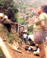
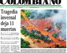
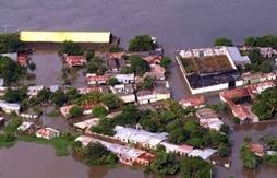
7 Threats from Climate Change and Hydroclimatic Variability and Deforestation Intensification of Storms and Floods Mesoscale Convective System triggered the flooding of Mocoa, Colombia, on April 1st, 2017: 350 dead
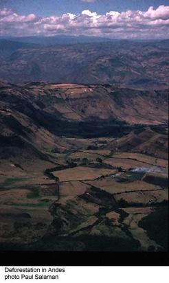
8 Deforestation in the Andes: Socio-Environmental Risks and Vulnerability + =
 LBA Courtesy: Carlos A.")
9 Two RHPs on South America: (1) LBA Courtesy: Carlos A. Nobre

10 Two RHPs on South America (2) La Plata Basin
11 None of these previous RHPs on South America have investigated their connections with the Andes Feedbacks between the low-lying Amazon and the upper Andean Amazon: Low-lying Amazon exports atmospheric water to the Andes The Andes export surface water (sediments, nutrients, soil) to the low-lying Amazon Poveda et al., Paleo-3 (2006)


12 The Andes and La Plata Basin Schematics of the winds connecting the Atlantic Ocean with the Andes across the Amazon and Orinoco River basin with the Andes and to La Plata River basin. Marengo et al. (2004)
13 Research Topics Ø Climate change impacts on Andean glaciers, paramos, punas, and cloud forests and their impact on the hydrologic cycle and water supply. Ø Risk, Vulnerability, Environmental Degradation in and caused by Andean cities. Ø Water, energy and carbon budgets along the Andes-Amazon gradients, their feedbacks at a wide range of space-time scales and the effects of climate variability and change. Ø Socio-environmental vulnerability of the Andes/Amazon region and the impacts of climate change and land use-land cover change. Ø Mechanisms to prevent further deforestation and environmental degradation of the Andean region through sustainable and rational exploitation of natural resources including water, biodiversity, forests, fisheries, and agriculture to improve the livelihoods of the region s inhabitants.
14 ANDEX Proposed Main Scientific Questions 1. What are the main physical processes driving the hydroclimatology of the Andes at a broad range of spatial and temporal scales, and their interactions with the neighboring oceans and major river basins of South America? 2. How climate change, deforestation and land use changes are affecting the hydroclimatological functioning of the Andes across the altitudinal gradients, from glaciers, to paramos, punas, cloud forests, rainforests, dry forests, etc.? 3. What are the major processes driving the coupling between the Andes and the low-lying river basins east of the Andes (Amazon, Parana, La Plata) at a wide range of spatiotemporal scales?
15 First Concrete Activity A Workshop will take place in Medellín, Colombia, in December 4 th -7 th, 2017, convened by Prof. Germán Poveda, National University of Colombia at Medellín. Confirmed participants: Peter van Oevelen (GEWEX director). Joan Cuxart Rodamilans (RHP, GEWEX) Silvina Solman (UBA, Argentina). René Garreaud (UCh, Chile). Jhan Carlo Espinoza (IGP, Peru). Rodney Martinez (CIIFEN, Ecuador). A representative from Bolivia (TBD).
An RHP for the Andes-Amazon System
 An RHP for the Andes-Amazon System Germán Poveda Universidad Nacional de Colombia, Medellín, Colombia A proposal for GEWEX June 11, 2016 Acknowledgements: These slides have been updated from an abridged
The Lesser Antilles. Dominican Republic), and Puerto Rico
, and Puerto Rico") The Caribbean Islands are archipelagoes or groups of islands. The major archipelagoes are: The Greater Antilles - Cuba, Jamaica, Hispaniola (Composed of Haiti and the Dominican Republic), and Puerto Rico
The Caribbean Islands are archipelagoes or groups of islands. The major archipelagoes are: The Greater Antilles - Cuba, Jamaica, Hispaniola (Composed of Haiti and the Dominican Republic), and Puerto Rico
*Latin America spans 7,000 miles, from Mexico to Tierra Del Fuego. *3 Regions: Central America, South America, and the Caribbean.
 Physical Geography Latin America spans 7,000 miles, from Mexico to Tierra Del Fuego *3 Regions: Central America, South America, and the Caribbean. *Intro clip: http://www.youtube.com/watch?v=cffp6rza3
Geographic Qualities of South America
 Geographic Qualities of South America 1. South America is the fourth largest continent in area. It is located in the Western Hemisphere, lying southwest of North America. Most of South America lies in
Essential Questions. 1. How have historical figures and events affected South America today?
 South America Essential Questions 1. How have historical figures and events affected South America today? 2. How has location affected the development of countries in South America? 3. How has the role
Latin America. Physical Geography
 Latin America Physical Geography Regions Latin America can be divided into separate regions based on physical geography or cultural geography. Regions If we look at physical geography Latin America has
Andean Mountain Initiative. World Mountain Forum 2018 Bishkek, October 23th, 2018
 Andean Mountain Initiative World Mountain Forum 2018 Bishkek, October 23th, 2018 The Andes range mountains The Andes are approximately 7,000 km long and are the world s longest terrestrial mountain range,
South American Countries. Capital Location Population Terrain Climate
 South American Countries Capital Location Population Terrain Climate Andes Mountains Four large areas that make up the Central Plains: Llanos, the Selva, the Gran Chaco, and the Pampas Brazilian Highlands
Latin America. Chapter 9 Physical Geography
 Latin America Chapter 9 Physical Geography Latin American Regions Middle America includes Mexico and the Central American countries The Caribbean Islands South America Mexico Landforms Sierra Madre Oriental
Chapter 10 Study Guide SOUTH AMERICA
 Chapter 10 Study Guide SOUTH AMERICA When Spain and Portugal competed for trading lands in the New World, who came up with the line of demarcation to settle the dispute? The Caribbean Countries: Who was
Chapter 19 Test on South America
 Name Part 1 - Labeling (27 pts.) Chapter 19 Test on South America Score A. Locate the countries and territory contained in the word box below on the map of South America on the next page. Write the name
The Andes Chap. 1 - Geographical context Chap. 2 - Large scale climate
 The Andes Chap. 1 - Geographical context Chap. 2 - Large scale climate René D. Garreaud Geophysics Department Universidad de Chile Center for Climate and Resilience Research, CR2 We all love the Andes..
A funny sounding lake. South American Landforms, Climate, and Vegetation
 A funny sounding lake South American Landforms, Climate, and Vegetation 3 4 Essential Question: How have physical features and climate affected the population distribution of Latin America? 5 I. Landforms
South America. pg. 520 (5 th) pg. 523 (6 th )
 pg. 523 (6 th )") South America pg. 520 (5 th) pg. 523 (6 th ) Venezuela Rich in Oil Lake Maracaibo Called Little Venice pg. 572 (5 th) pg. 574 (6 th ) Caracas 8 miles Inland 3000 pg. 572 (5 th) pg. 574 (6 th ) Caracas
South America pg. 520 (5 th) pg. 523 (6 th ) Venezuela Rich in Oil Lake Maracaibo Called Little Venice pg. 572 (5 th) pg. 574 (6 th ) Caracas 8 miles Inland 3000 pg. 572 (5 th) pg. 574 (6 th ) Caracas
CHAPTER 12. South America. Section 1: Natural Environments Section 2: History and Culture Section 3: South America Today. HOLT World Geography
 CHAPTER 12 South America Section 1: Natural Environments Section 2: History and Culture Section 3: South America 1 Section 1 Natural Environments Objectives: What are the major landforms and rivers of
Latin America s Physical Geography. EQ: What are characteristics of Latin America s physical features?
 Latin America s Physical Geography EQ: What are characteristics of Latin America s physical features? Your Task: We are going to participate in a Museum Walk! You will travel around the room with a partner
Objective. Students will familiarize themselves with the physical features and climates of Latin America.
 Journal Write KWL What do you KNOW about Latin America? What do you WANT TO KNOW about Latin America? What did you LEARN today that you didn t know before? Latin America Objective Students will familiarize
Friday, November 10, 2017
 Friday, November 10, 2017 Andes and Midlatitude Countries Objective: Summarize the main physical features and regions of the Southern Cone. Identify and locate the urban centers and understand the pattern
Mrs. Reifsnyder World Geography. Unit 8: Latin America Study Guide SOLs Addressed: WG. 1c, 2b, 3c, 4, 10b/c
 Mrs. Reifsnyder World Geography Unit 8: Latin America Study Guide SOLs Addressed: WG. 1c, 2b, 3c, 4, 10b/c Essential Questions: - In what ways do physical, economic, and cultural characteristics influence
Name: Hour: Day: The Land and Its Regions (pg ) Define, in your own words, escarpment. Define, in your own words, sertão
 Define, in your own words, escarpment. Define, in your own words, sertão") Name: Hour: Day: World Geography Guided Reading Notes Chap 12 & 13 --- ANSWER IN COMPLETE SENTENCES!!!! READ EACH QUESTION CAREFULLY & ANSWER COMPLETELY!!!! Objectives: Upon completion of reading you should
Name: Hour: Day: World Geography Guided Reading Notes Chap 12 & 13 --- ANSWER IN COMPLETE SENTENCES!!!! READ EACH QUESTION CAREFULLY & ANSWER COMPLETELY!!!! Objectives: Upon completion of reading you should
Mrs. Davis s Adventures
 Mrs. Davis s Adventures Latin America Countries & Political Map NAME: DATE: PERIOD: DIRECTIONS: Use your mapping skills and textbook pages: 127, 97, and 3 to complete Mrs. Davis s Story. Transfer the countries
1st Period Mr. Chavira WORLD GEOGRAPHY. Hector Rodriguez
 1st Period Mr. Chavira WORLD GEOGRAPHY Hector Rodriguez P a g e 1 Table of Contents Latin America Page 2 o Maps Economic Map Page 3 Political Map Page 4 Population Map Page 5 Physical Page 6 o Notes Physical
WORLD GEOGRAPHY. Hector Rodriguez
 Mr. Chavira 9th Period WORLD GEOGRAPHY Hector Rodriguez P a g e 1 Table of Contents Latin America Page 2 o Maps Economic Map Page 3 Political Map Page 4 Population Map Page 5 Physical Page 6 o Notes Physical
Impacts of glacier retreats in The Andes 1914 Our times
 Impacts of glacier retreats in The Andes 1914 Our times Source; Cobos, 2002 Dr. Andrés Rivera Centro de Estudios Científicos, CECS, Chile www.glaciologia.cl Present status of glaciers in the Andes: Snow
Water in the Amazon. By Heather and Georgie
 Water in the Amazon By Heather and Georgie The Amazon is the world s largest tropical rainforest. The Amazon is so big that the U.K and Ireland would fit into it 17 times. The Amazon River It s length
South America (except Colombia for HA) Date of submission 02/08/12. ECHO Quito team MONTHLY REPORT
 Date of submission 02/08/12. ECHO Quito team MONTHLY REPORT") ANNEX IV-3 EUROPEAN COMMISSION HUMANITARIAN AID OFFICE (ECHO) Monthly report number 2012/07 Month July Country South America (except Colombia for HA) Date of submission 02/08/12 Author ECHO Quito team
ANNEX IV-3 EUROPEAN COMMISSION HUMANITARIAN AID OFFICE (ECHO) Monthly report number 2012/07 Month July Country South America (except Colombia for HA) Date of submission 02/08/12 Author ECHO Quito team
Comprehension Questions:
 Unit 3: Central & South america Comprehension Questions: 1. What is the driest desert on earth? Atacama Desert 2. What two water routes were discovered in the 1500s to get around the tip of South America?
EUROPEAN COMMISSION DIRECTORATE-GENERAL HUMANITARIAN AID AND CIVIL PROTECTION - ECHO
 EUROPEAN COMMISSION DIRECTORATE-GENERAL HUMANITARIAN AID AND CIVIL PROTECTION - ECHO Monthly report number 2013/08 Month AUGUST Country South America (except Colombia for HA) Date of submission 10/09/13
Regional Atlas: Introduction to Latin America
 Chapter 9, Section World Geography Chapter 9 Regional Atlas: Introduction to Latin America Copyright 2003 by Pearson Education, Inc., publishing as Prentice Hall, Upper Saddle River, NJ. All rights reserved.
Public Works Research Institute
 Public Works Research Institute INTERNATIONAL WORKSHOP ON WATER HAZARD AND RISK MANAGEMENT SOME EXPERIENCES OF FLOOD MANAGEMENT IN ARGENTINA VÍCTOR POCHAT National Director for Water Policies,Coordination
LAST TIME (Happy 300 th Birthday Ben Franklin!)
") LAST TIME (Happy 300 th Birthday Ben Franklin!) Latin American Diversity: Introduction Physical Geography of Mexico, Caribbean, and Central America: 1. Mexican drylands 2. Mesoamerican Highlands 3. Coastal
LAST TIME (Happy 300 th Birthday Ben Franklin!) Latin American Diversity: Introduction Physical Geography of Mexico, Caribbean, and Central America: 1. Mexican drylands 2. Mesoamerican Highlands 3. Coastal
Latin America. Physical Geography
 + Latin America Physical Geography + I. Landforms A. Caribbean & Central America 1. Mexico is dominated by two mountain chains, collectively called the Sierra Madre. A high plateau is situated in between.
STUDY GUIDE. The Land. Physical Features of Latin America. Chapter 8, Section 1. Terms to Know DRAWING FROM EXPERIENCE ORGANIZING YOUR THOUGHTS
 For use with textbook pages 193 198. The Land Terms to Know cordillera A mountain range that runs parallel to another mountain range (page 194) altiplano A high plain (page 194) escarpment A steep cliff
Protecting Mountain Biodiversity. IPROMO (Italy) July
 July") Protecting Mountain Biodiversity IPROMO (Italy) July 9 23 2010 Juan Antonio González Miguel Lillo Foundation Tucumán (Argentina) juanantoniogonzlez@gmail.com Argentinean Northwest (21º - 32º S) South América
Protecting Mountain Biodiversity IPROMO (Italy) July 9 23 2010 Juan Antonio González Miguel Lillo Foundation Tucumán (Argentina) juanantoniogonzlez@gmail.com Argentinean Northwest (21º - 32º S) South América
THE PHYSICAL AND CULTURAL GEOGRAPHY OF SOUTH AMERICA
 THE PHYSICAL AND CULTURAL GEOGRAPHY OF SOUTH AMERICA 1 Global location Relative to European capitals Relative to US cities Time zones Two oceans Pacific rim countries - farther to Asia than USA Not on
Latin America. Introduction
 Latin America Introduction What are the 5 Themes of Geography? Draw lines to connect the theme to the definition: Location How humans and the environment impact each other Physical and human characteristics
Month June 2011 South America (except Colombia for HA) Date of submission 01/07/11 MONTHLY REPORT
 Date of submission 01/07/11 MONTHLY REPORT") ANNEX IV-3 EUROPEAN COMMISSION HUMANITARIAN AID OFFICE (ECHO) Monthly report number 2011/6 Month June 2011 Country South America (except Colombia for HA) Date of submission 01/07/11 Author ECHO Quito MONTHLY
ANNEX IV-3 EUROPEAN COMMISSION HUMANITARIAN AID OFFICE (ECHO) Monthly report number 2011/6 Month June 2011 Country South America (except Colombia for HA) Date of submission 01/07/11 Author ECHO Quito MONTHLY
September. ECHO Quito team MONTHLY REPORT
 EUROPEAN COMMISSION HUMANITARIAN AID OFFICE (ECHO) Monthly report number 2012/09 Month Country September South America (except Colombia for HA) Date of submission 04/10/12 Author ECHO Quito team 1. SUMMARY
Ecological impacts in mountain protected areas
 Ecological impacts in mountain protected areas International Programme on Research and Training on Sustainable Management of Mountain Areas (IPROMO) July 2010 International Centre for Ecotourism Research,
South America: Physical Geography
 This website would like to remind you: Your browser (Apple Safari 4) is out of date. Update your browser for more security, comfort and the best experience on this site. Encyclopedic Entry South America:
ANNEX IV-3 EUROPEAN COMMISSION HUMANITARIAN AID OFFICE (ECHO) MONTHLY REPORT 1. SUMMARY / MAIN HIGHLIGHTS. Monthly report number 2011/8
 MONTHLY REPORT 1. SUMMARY / MAIN HIGHLIGHTS. Monthly report number 2011/8") ANNEX IV-3 EUROPEAN COMMISSION HUMANITARIAN AID OFFICE (ECHO) Monthly report number 2011/8 Month August Country South America (except Colombia for HA) Date of submission 06/08/11 Author ECHO Quito team
ANNEX IV-3 EUROPEAN COMMISSION HUMANITARIAN AID OFFICE (ECHO) Monthly report number 2011/8 Month August Country South America (except Colombia for HA) Date of submission 06/08/11 Author ECHO Quito team
CHAPTER Latin America. Regional Atlas Study Guide. 2 Chapter A. As You Read. B. Reviewing Vocabulary
 CHAPTER 28 9 Many Th ew inventions new Regional Atlas Study Guide Latin America Directions: As you work through the Regional Atlas, complete the chart below by writing two details about each Latin American
South America. Land of Color and Contrast
 South America Land of Color and Contrast Home to: *The world s largest river system *The longest mountain chain, and second tallest mountains *Earth s driest desert *One of the world s great grassland
ANNEX IV-3 EUROPEAN COMMISSION HUMANITARIAN AID OFFICE (ECHO) MONTHLY REPORT 1. SUMMARY / MAIN HIGHLIGHTS. Monthly report number 2011/7
 MONTHLY REPORT 1. SUMMARY / MAIN HIGHLIGHTS. Monthly report number 2011/7") ANNEX IV-3 EUROPEAN COMMISSION HUMANITARIAN AID OFFICE (ECHO) Monthly report number 2011/7 Month July 2011 Country South America (except Colombia for HA) Date of submission 02/08/11 Author ECHO Quito MONTHLY
ANNEX IV-3 EUROPEAN COMMISSION HUMANITARIAN AID OFFICE (ECHO) Monthly report number 2011/7 Month July 2011 Country South America (except Colombia for HA) Date of submission 02/08/11 Author ECHO Quito MONTHLY
ECORREGIONAL ASSESSMENT: EASTERN CORDILLERA REAL ORIENTAL PARAMOS AND MONTANE FORESTS
 ECORREGIONAL ASSESSMENT: EASTERN CORDILLERA REAL ORIENTAL PARAMOS AND MONTANE FORESTS The Nature Conservancy, EcoCiencia y Fundación AGUA. 2005. Evaluación Ecorregional de los Páramos y Bosques Montanos
The Pilcomayo River Basin Argentina
 The Pilcomayo River Basin Argentina Yangareko ( Janis Alcorn, Alejo Zarzycki, Alonzo Zarzycki, Luis Maria de la Cruz) Governance and Ecosystems Management for the CONservation of BIOdiversity www.gemconbio.eu
Chapter 13: Life in the Central Andes- Adapting to a Mountainous Region
 Chapter 13: Life in the Central Andes- Adapting to a Mountainous Region 1. Introduction La Paz, Bolivia, is the highest big city in the world, sitting at 12,000 feet above sea level in the central Andes
THE ANDEAN AREA....How does the rich countries development affect some poor and 1. distant countries
 THE ANDEAN AREA...How does the rich countries development affect some poor and 1 distant countries 1. Geographical situation of the Andean area South America view 2 Andes mountain range Amazonian basin
Status of Mangroves in Belize
 Status of Mangroves in Belize State of the Coastal zone Summit June 7 th 2012 Nadia Bood*, Emil Cherrington and Tim Smith Outline Introduction to mangroves Importance of mangrove to Belize National status
SESSSION 26. Dr. Raquel Gil Montero Universidad Nacional de Tucumán and CONICET, Argentina
 SESSSION 26 International Economic History Congress, Helsinki 2006; Session 26: Families, Kinship and Forms of Land Ownership in Mountain Societies (16th-20th Centuries) Dr. Raquel Gil Montero Universidad
ECOREGIONAL ASSESSMENT EQUATORIAL PACIFIC EXECUTIVE SUMMARY
 ECOREGIONAL ASSESSMENT EQUATORIAL PACIFIC The Nature Conservancy, Fundación Agua, EcoCiencia, Fundación Jatun Sacha, CDC Ecuador, CDC UNALM 2004. Portafolio de Sitios Prioritarios para la Conservación
Portuguese Language - Fostering National Unity
 Geography Brazil Brazil Portuguese Language - Fostering National Unity 11 dialects of Portuguese Influenced by Amerindian and African languages, creating differences between Portuguese spoken in Brazil
Latin America and The Caribbean. A Closer Look.
 Latin America and The Caribbean A Closer Look. Mexico Capital: Mexico City The Location of Mexico Mexico is the second-largest country by size and population in Latin America.but the Largest Spanish -
Month February 2011 South America (except Colombia for HA) Date of submission 09/03/11 MONTHLY REPORT
 Date of submission 09/03/11 MONTHLY REPORT") EUROPEAN COMMISSION HUMANITARIAN AID OFFICE (ECHO) Monthly report number 2011/2 Month February 2011 Country South America (except Colombia for HA) Date of submission 09/03/11 Author ECHO Quito MONTHLY
EUROPEAN COMMISSION HUMANITARIAN AID OFFICE (ECHO) Monthly report number 2011/2 Month February 2011 Country South America (except Colombia for HA) Date of submission 09/03/11 Author ECHO Quito MONTHLY
Andean Competitiveness
 Background 1. Poor countries, high income inequality 2. Failure of ISI brought inflation, deep economic crisis and political crisis in the 70s 3. Market oriented economic reforms in the 80s and 90s 4.
VI Meeting of the Executive Steering Committee
 VI Meeting of the Executive Steering Committee 23 24 November, 2004 Lima, Republic of Peru 2004 Project Portfolio INITIATIVE FOR THE INTEGRATION OF REGIONAL INFRASTRUCTURE IN SOUTH AMERICA Project Portfolio
LOCATION, CLIMATE, AND NATURAL RESOURCES OF MEXICO
 SS6G3 The student will explain the impact of location, climate, distribution of natural resources, and population distribution on Latin America and the Caribbean. a. Compare how the location, climate,
The Northern Tropics
 The Northern Tropics The Guianas Countries Guyana, Suriname, French Guyana Culture reflects colonial history Official Languages Guyana English Suriname Dutch French Guyana - French Religions Suriname and
Rivers. Highlights of some of the World s Most Famous Rivers!
 Rivers Highlights of some of the World s Most Famous Rivers! Directions This Power Point presentation contains information about some of the most famous rivers in the world! Students should use this presentation
Implementation Status & Results Andean Countries Adaptation to the Impact of Rapid Glacier Retreat in the Tropical Andes (P098248)
") Public Disclosure Authorized Public Disclosure Authorized The World Bank Implementation Status & Results Andean Countries Adaptation to the Impact of Rapid Glacier Retreat in the Tropical Andes (P098248)
Public Disclosure Authorized Public Disclosure Authorized The World Bank Implementation Status & Results Andean Countries Adaptation to the Impact of Rapid Glacier Retreat in the Tropical Andes (P098248)
6th Grade Western Hemisphere Geography
 6th Grade Western Hemisphere Geography Multiple Choice Identify the choice that best completes the statement or answers the question. 1 Latin America is located in the A Northern Hemisphere. C Western
Spanish Countries. & Capitals. Map Labeling & Quiz SpanishMadeEasy.net
 Spanish Countries & Capitals Map Labeling & Quiz 2016 SpanishMadeEasy.net Table of Contents Map Labeling: Spanish-Speaking Countries................................ 3 Map Labeling: Spanish-Speaking Capitals..................................
Quechua PHRASEBOOK & DICTIONARY
 Quechua PHRASEBOOK & DICTIONARY Acknowledgments Publisher Mina Patria Associate Product Director Angela Tinson Product Editor Martine Power Series Designer James Hardy Language Writer Serafín M Coronel-Molina
6th Grade Western Hemisphere Geography
 6th Grade Western Hemisphere Geography Multiple Choice Identify the choice that best completes the statement or answers the question. 1 Latin America is located in the A Northern Hemisphere. C Western
Introduction. We hope you find these materials useful and would welcome any feedback.
 Introduction This planning pack was produced with teachers from County Durham following a visit to São Paulo. The materials support the teaching of geography at key stage one and two within the context
Community-based Adaptation, Experiences in Bolivia
 Community-based Adaptation, Experiences in Bolivia Clea Paz, Conservation International-Bolivia Stephan Halloy, The Nature Conservancy Ninón Ríos and James Aparicio, Naturaleza y Comunidad-PNCC Oscar Saavedra,,
Climate Change Adaptation in
 Climate Change Adaptation in the Hindu Kush Himalaya Experience from the Great Himalaya Trail My Climate Initiative ----------------------- ----------------------- PARIBESH PRADHAN Overview The Great Himalaya
Climate Change Impacts on Glacial Lakes and Glacierized Basins in Nepal and Implications for Water Resources
 Climate Change Impacts on Glacial Lakes and Glacierized Basins in Nepal and Implications for Water Resources Suresh R. Chalise 1, Madan Lall Shrestha 2, Om Ratna Bajracharya 2 & Arun Bhakta Shrestha 2
Exploring South America Learning Lapbook with Study Guide
 A J T L Grades 1-4 Exploring South America Learning Lapbook with Study Guide A Journey Through Learning www.ajourneythroughlearning.com Copyright 2013 A Journey Through Learning 1 Authors-Paula Winget
Cosmetics and Toiletries. April 2014
 Cosmetics and Toiletries April 2014 INDEX Colombian Exports Cosmetics and Toiletries Key Points Main Destinations Investment Opportunities Main Products Opportunities COLOMBIAN EXPORTS The non-mining segment*
ASCENDING RIBEX SOUTH AMERICA. 6500km from South to North in inflatable boats Argentina. Paraguay. Bolivia. Brazil WORLD WIDE EXPEDITIONS
 2018 ASCENDING SOUTH AMERICA 6500km from South to North in inflatable boats Argentina. Paraguay. Bolivia. Brazil RIBEX WORLD WIDE EXPEDITIONS Ascending South America Expedition is an unprecedented and
1 What do you know about Brazil? What. 2 What would you like to know about Brazil? 3 Look at the short movie clips below to see
 This fact sheet introduces you to the beautiful country of Brazil with its varied scenery. 1 What do you know about Brazil? What is Brazil famous for? Make a list of the facts that you know about the country
EU Trade policy in Latin America
 EU Trade policy in Latin America Thomas LE VAILLANT European Commission DG TRADE - Relations with Latin America Topics 1.Trade and investment flows 2. Regionalism in Latin America 3. State of play 4. Architecture
DOWNLOAD OR READ : MAPPING SOUTH AMERICA PDF EBOOK EPUB MOBI
 DOWNLOAD OR READ : MAPPING SOUTH AMERICA PDF EBOOK EPUB MOBI Page 1 Page 2 mapping south america mapping south america pdf mapping south america South America PDF maps Free South America maps for students,
UNITED NATIONS EDUCATIONAL, SCIENTIFIC AND CULTURAL ORGANIZATION CONVENTION CONCERNING THE PROTECTION OF THE WORLD CULTURAL AND NATURAL HERITAGE
 World Heritage Distribution limited 27 COM WHC-03/27.COM/INF.13 Paris, 23 June 2003 Original : English/French UNITED NATIONS EDUCATIONAL, SCIENTIFIC AND CULTURAL ORGANIZATION CONVENTION CONCERNING THE
United Nations Environment Programme
 United Nations Environment Programme Twelfth Forum of Ministers of the Environment of Latin America and the Caribbean Bridgetown, Barbados 2 nd to 7 th March 2000 A. Preparatory Meeting of Experts 2 nd
Project title Specific Objective Start date End Date
 DISASTER PREPAREDNESS PROJECTS - DIPECHO ACTION PLAN 2013-2014 Project title Specific Objective Start date End Date ARGENTINA EC -PNUD Strengthening the disaster risk reduction and disaster management
The Coasts Of Chile, Bolivia, And Peru By Anon
 The Coasts Of Chile, Bolivia, And Peru By Anon If you are searching for a book by Anon The Coasts of Chile, Bolivia, and Peru in pdf format, then you have come on to the faithful site. We furnish full
Fieldwork Dates AmericasBarometer
 Fieldwork Dates AmericasBarometer 2004-2014 This document contains information regarding fieldwork s for the AmericasBarometer project, 2004-2014. Some information may be incomplete and we will up the
BIODIVERSITY NEW ECONOMIC VARIABLE
 2016 BUSINESS AND BIODIVERSITY FORUM SECTION H: TOURISM DECEMBER 3, 2016 PERU One of the 17 megadiverse countries in the world (UNESCO 1998). 84 of 104 life zones according to the Holdridge System. 55
The Geography Of Ecuador Essay
 The Geography Of Ecuador Essay We can write The Geography Of Ecuador. We provides students with professionally written essays, research papers, term papers, reviews, theses, dissertations and more. Once
National mercury assessment baseline in Bolivia Carlos I. Molina 1, Fernando Cisneros 2, Lila Sainz 3 and Marc Pouilly 4
 National mercury assessment baseline in Bolivia Carlos I. Molina 1, Fernando Cisneros 2, Lila Sainz 3 and Marc Pouilly 4 1. Unidad de Calidad Ambiental, Instituto de Ecología, Universidad Mayor de San
The hemispheric program for the eradication of foot and mouth disease challenges and lessons learned
 The hemispheric program for the eradication of foot and mouth disease challenges and lessons learned OIE/FAO Global Conference on Foot and Mouth Disease. The Way Towards Global Control 24 26 June 2009
COPYRIGHTED MATERIAL [1] L ANDS AND CLIMATES
![COPYRIGHTED MATERIAL [1] L ANDS AND CLIMATES](/thumbs/81/82837436.jpg "COPYRIGHTED MATERIAL [1] L ANDS AND CLIMATES") [1] L ANDS AND CLIMATES B ROADLY considered, Latin America s geography is not friendly to human occupation, or favorable to people s activities. The struggle to live and thrive on the land has produced
[1] L ANDS AND CLIMATES B ROADLY considered, Latin America s geography is not friendly to human occupation, or favorable to people s activities. The struggle to live and thrive on the land has produced
LOCATION, LOCATION, LOCATION! Mexico, Venezuela, Cuba, and Brazil
 LOCATION, LOCATION, LOCATION! Mexico, Venezuela, Cuba, and Brazil GPS and E.Q. GPS: SS6G3 The student will explain the impact of location, climate, distribution of natural resources, and population distribution
COLOMBIA IN THE WORLD
 Libertad Orden y GROWTH, CONFIDENCE AND OPPORTUNITIES TO INVEST OIL GOODS AND SERVICES COLOMBIA IN THE WORLD Colombia is one of the top twenty oil-producing countries, with a production of over a million
Information Session: Thursday, October 4 th at 12:30pm Maxwell-Dworkin G J-term Experience in the Peruvian Amazon and Highlands
 Information Session: Thursday, October 4 th at 12:30pm Maxwell-Dworkin G135 2019 J-term Experience in the Peruvian Amazon and Highlands Solving Global Challenges through Innovation Agriculture, an Alternative
Latin America: Physical Geography
 Page 1 of 7 Latin America: Physical Geography TERMS & NAMES tributary deforestation Tropical Zone El Niño MAIN IDEA Latin America s landforms, bodies of water, and climate offer a wide range of environments
Why is the US industry and agriculture prosperous? The US industry and agriculture is so prosperous because it has many different natural resources.
 Ch. 1-7 Study Guide Why is the US industry and agriculture prosperous? The US industry and agriculture is so prosperous because it has many different natural resources. What likely drew immigrants to the
UNIT 3 Extra Review for Chapters 9-11
 UNIT 3 Extra Review for Chapters 9-11 Mexico Central America Caribbean Islands Middle America is Central America, Mexico, and the Islands of the Caribbean Central America is a region within Middle America.
2012. Proceedings of the 11 European Geoparks Conference. AGA Associação Geoparque Arouca, Arouca, 5-6.
 References to this volume It is suggested that either the following alternatives should be used for future bibliographic references to the whole or part this volume: th Sá, A.A., Rocha, D., Paz, A. & Correia,
BOLIVIA S GLACIER: A VANISHING FUTURE
 UN IN ACTION Release Date: December 2009 Programme No. 1215 Length: 5 18 Languages: English, French, Spanish, Russian BOLIVIA S GLACIER: A VANISHING FUTURE VIDEO SNOWY PEAKS OF GLACIERS AUDIO For thousands
EUROPEAN COMMISSION DIRECTORATE-GENERAL HUMANITARIAN AID AND CIVIL PROTECTION - ECHO
 EUROPEAN COMMISSION DIRECTORATE-GENERAL HUMANITARIAN AID AND CIVIL PROTECTION - ECHO Monthly report number 2013/10 Month OCTOBER Country South America (except Colombia for HA) Date of submission 08/11/13
ACTION PLAN OF THE SOUTH AMERICAN DEFENSE COUNCIL 2012
 ACTION PLAN OF THE SOUTH AMERICAN DEFENSE COUNCIL 2012 AXE 1: DEFENSE POLICY 1.A Form a work group responsible for establishing a methodology to standardize a mechanism for transparency in the military
Observation of cryosphere
 Observation of cryosphere By Sagar Ratna Bajracharya (email: sagar.bajracharya@icimod.org) Samjwal Ratna Bajracharya Arun Bhakta Shrestha International Centre for Integrated Mountain Development Kathmandu,
Chapter 21: EAST AFRICA
 Chapter 21: EAST AFRICA Physical Geography of East Africa Landforms East Africa is a diverse landscape of different plains, volcanic mountains, and plateaus cut by a large valley and marked by many rivers
for HUB MSMEs IX Meeting of the Executive Steering Committee of IX Meeting of the Executive Steering Committee of IIRSA
 INITIATIVE FOR THE INTEGRATION OF REGIONAL INITIATIVE FOR THE INTEGRATION OF REGIONAL INFRASTRUCTURE IN SOUTH AMERICA INFRASTRUCTURE IN SOUTH AMERICA IIRSA IIRSA ANNEX ANNEX 13 11 Project: PARAGUAY-PARANA
GEOGRAPHY OF THE WESTERN HEMISPHERE
 GEOGRAPHY OF THE WESTERN HEMISPHERE LEARNING LOG Write clear directions that describe how to get from one place to another. Choose 2 locations that other people might not know about. Did you use a map
GRANDE News Letter Volume1, No.4, March 2013
 GRANDE News Letter Volume1, No.4, March 2013 New technologies for the study of tropical glaciers Prof. Edson RAMIREZ Institute of Hydraulics and Hydrology, Universidad Mayor de San Andres, Bolivia Techniques
INTRODUCTION. A marvelous land of friendly people. It possesses a large biodiversity that encompasses
 c INTRODUCTION Colombia, country of incredible diversity and charm. Its varied geography, its history full of mystery and adventure, its people and cultures have fascinated the world for centuries. The