An Employee-Owned Company
|
|
|
- Sophia Bruce
- 5 years ago
- Views:
Transcription
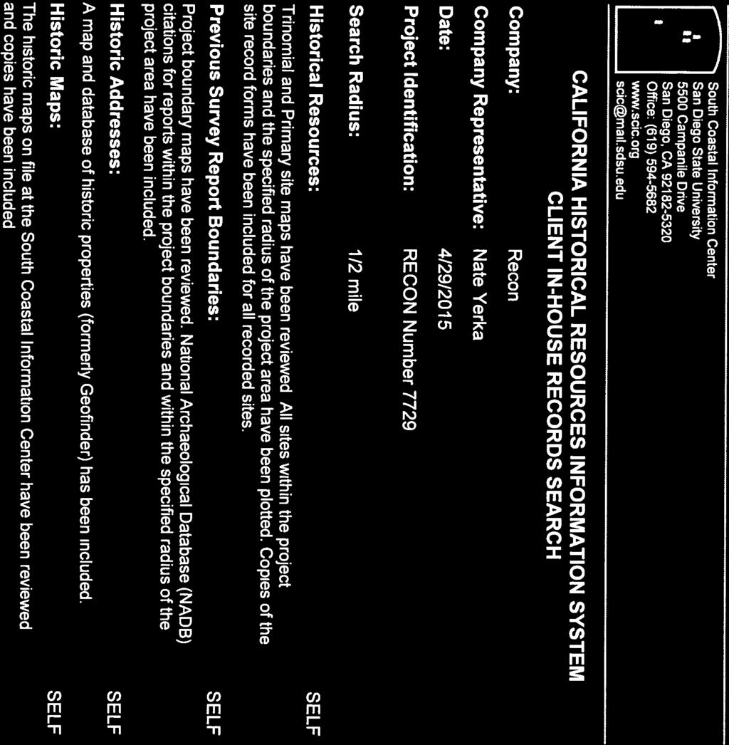
1 An Employee-Owned Company August 27, 2018 Mr. Luis Valdez Engineering Manager Sweetwater Authority 505 Garrett Avenue Chula Vista, CA Reference: Results of the Cultural Resources Survey for the 36-inch Transmission Water Main Replacement (RECON Number 7729) Dear Mr. Valdez: The 36-inch Transmission Main Replacement Project (proposed project) entails the installation of approximately 16,500 linear feet of water transmission main (main) operated by the Sweetwater Authority (Authority), and the abandonment of the existing main. This letter describes the background, methods, and results of RECON Environmental, Inc. s (RECON) cultural resources survey conducted for the proposed project. RECON completed a field and archival investigation to gather information on the cultural resources within or adjacent to the project alignment. The fieldwork consisted of an on-foot survey of the project alignment. The archival research was a record search of the database maintained by the South Coastal Information Center (SCIC) and a search of the files at the Native American Heritage Commission (NAHC) in Sacramento. One cultural resource was identified adjacent to one of the staging areas. RECON recommends archaeological and Native American monitoring during trenching for three segments of the pipeline. Project Description The Authority, as the lead agency pursuant to the California Environmental Quality Act (CEQA), is proposing the installation of approximately 16,500 linear feet of main and the abandonment of the existing main. The majority of the main would be installed within proximity to the existing alignment, while some portions would be realigned. The project alignment is located in the Sweetwater River valley, from just west of Interstate 805 (I-805) to State Route 125 (SR-125), within portions of the city of Chula Vista and unincorporated San Diego County, within the communities of Bonita and Sunnyside (Figure 1). The project is in the La Nación land grant on the U.S. Geological Survey (USGS) National City quadrangle (USGS 1996; Figure 2). The project alignment is composed of five segments, primarily along Bonita Road, but also within a segment of Willow Road and portions of the Chula Vista Golf Course and the Bonita Golf Club (Figure 3). In each segment, installation of the new main would occur first, followed by the abandonment of the existing main. Construction would be accomplished primarily through open trenching, while jack and bore method would be utilized for a storm drain crossing along a limited portion of Bonita Road for Segment 1. Open cut trenching involves excavating a linear trench and installing the new main and associated appurtenances (such as air release valves and manholes). Construction would proceed at approximately 80 feet per day for the 36-inch and 48-inch main. Project activities may not necessarily proceed in order (i.e., from Segment 1 east to Segments 2 and 3); however, they are organized in this manner for purposes of this document Fifth Avenue, San Diego, CA reconenvironmental.com SAN DIEGO CENTRAL COAST BERKELEY TUCSON
2 Batiquitos Lagoon San Marcos Carlsbad Encinitas Solana Beach E s c o n d i d o Rancho Santa Fe C r e e k R i D a n S Fairbanks Ranch i v uu g e r e Lake Hodges ii tt o Escondido Poway S A N D I E G O C O U N T Y Ramona UV 78 San Diego Country Estates Del Mar UV 56 Los Penasquitos Canyon Presv San Vicente Reservoir 5 Coronado SAN BERNARDINO USMC AIR STATION MIRAMAR Mission Trails UV 163 Regional Park UV 282 UV 75 San Diego National City O t a S w e t w e a a UV 54 t USMC AIR STATION MIRAMAR e UV 94 v e r R i r UV 125 Casa de Oro-Mount Helix La Presa Spring Valley S Sweetwater Reservoir e t w v e r e w UV 67 Lakeside Winter Gardens R i a tt e r S a UV 8 52 La Mesa Lemon Grove Chula Vista Santee n R Lower Otay Reservoir Barona Reservation Capitan Grande Reservation i D u D i l g e v e r z u o Bostonia Harbison Canyon El Cajon a C r a Cleveland NF El Capitan Reservoir Granite Hills Crest Loveland Sycuan Reservoir Reservation Rancho San Diego Jamul Jamul Indian Village e r e k ORANGE RIVERSIDE Imperial Beach y v R i e r UV 905 SAN DIEGO M E X I C O MEXICO 0 Miles 5[ Project Alignment M:\JOBS4\7729\common_gis\2018_Biotec\fig1.mxd 4/11/2018 fmm FIGURE 1 Regional Location

 48-inch Transmission Main Potential Staging Area Feet")
3 Map Source: USGS 7.5 minute topographic map series, National City quadrangle, 1975, La Nacion land grant Segment 4 Segment 3 Segment 5 Segment 2 Segment 1 0 Existing Pipeline Project Alignment 32-inch Transmission Main (to be abandoned) 36-inch Transmission Main 36-inch Transmission Main (to be abandoned) 48-inch Transmission Main Potential Staging Area Feet 2,000 [ FIGURE 2 Project Location on USGS Map M:\JOBS4\7729\common_gis\2018_Arc\fig2.mxd 5/10/2018 fmm

 36-inch Transmission Main 36-inch Transmission Main (to be abandoned) 48-inch Transmission Main Feet 1,500 [ FIGURE 3 Project Alignment on Aerial Photograph")
4 Image source: Nearmap (flown February 2018) V U 54 ISE VA LL EY P LA ZA PA R A D W VE O LI OO TW AN ER SAN DIEGO COUNTY DM REO AT V U 125 SW EE CITY OF SAN DIEGO PO T O M AC NATIONAL CITY S AN MI G UEL Segment 4 CEN T RA L CO V U 54 ND A A TO N AW LC AN YO N Segment 3 R VA LL E Y SAN DIEGO COUNTY RR A EO 805 Segment 5 NATIONAL CITY W S W EE TWAT IL ER LO W Segment 2 CITY OF CHULA VISTA SAN DIEGO COUNTY OTAY LAKE S Segment 1 CITY OF CHULA VISTA PL E ST AZA BONITA RD BO NI T AR D 0 Municipal Boundaries Existing Pipeline Potential Staging Area Proposed Pipeline 32-inch Transmission Main (to be abandoned) 36-inch Transmission Main 36-inch Transmission Main (to be abandoned) 48-inch Transmission Main Feet 1,500 [ FIGURE 3 Project Alignment on Aerial Photograph M:\JOBS4\7729\common_gis\2018_Arc\fig3.mxd 5/10/2018 fmm
5 Mr. Luis Valdez Page 5 August 27, 2018 Following installation of the new main, the existing main would be abandoned. The existing main would be pumped full of concrete slurry or similar material. This would prevent collapse of the abandoned pipe. The abandonment operations would not occur until the replacement water main has been constructed, tested, and connected for use. The slurry material would be mixed in an automated batch plant and delivered to the site in ready-mix trucks. The slurry material would be continuously pumped in at entry points (i.e., approximately 5 feet by 5 feet), approximately 600 to 700 feet apart along the abandoned alignment. Where these entry points are located, the ground would be restored to its previous condition. Conceptual construction staging areas were included in the analysis for this document but have not been selected or secured for use at this time. The staging areas in Segments 1 and 4 were surveyed as part of the cultural resources survey. Staging areas would be finalized following selection of a construction contractor. If staging areas are identified that are not included in this analysis, they would be required to be located in previously disturbed or developed areas, or otherwise require further analysis regarding impacts to cultural resources. Segments 1 and 2 would occur entirely within Bonita Road from generally the I-805 east to Glenn Abbey Drive. Segment 3 starts in Bonita Road just west of Allen School Road, extends north into the Chula Vista Golf Course parking lot, and continues northeast into the golf course across the tee box for the first hole. From here, it continues northeast across the driving range and Sweetwater River towards the tenth hole. Segment 4 begins at the Sunnyside Bridge where Bonita Road meets San Miguel Road. The existing 36-inch transmission main extends from the bridge northeast through the middle of the golf course. This portion of the transmission main would be abandoned in place. The new transmission main would be realigned to the southern and eastern perimeter of the golf course, along previously disturbed trails and Conduit Road, which would allow for better maintenance access and would avoid impacting wetlands associated with the Sweetwater River. At the northern portion of this segment, the alignment would extend under SR-125. Segment 5 is located adjacent to Segments 2 and 3 on the southwest side of Willow Street near Bonita Road. Segment 5 is the transmission main interconnection between the 42-inch main and 36-inch main at Willow Street. An existing section of 32-inch transmission main currently extends south-southwest from the northern extent of the Kaiser Permanente parking lot, adjacent to the medical office buildings. This section of main will be abandoned. The new main would be installed along the northeastern perimeter of the parking lot and within a small reach of Willow Street within previously developed areas. The new main alignment has been designed to avoid sensitive areas while also avoiding conflicts with the City of Chula Vista s proposed storm drain improvements within Willow Street. Natural Setting The project alignment is located within the Sweetwater River Valley. The Sweetwater River runs more or less parallel to the project alignment. During prehistoric times, access to the water was a determining factor in identifying where people lived and collected resources. The area has been developed by two golf courses and trails within the County of San Diego s Sweetwater Regional Park. To the north and south of the project alignment, there are residential and commercial developments. Elevation ranges from 40 feet above mean sea level (AMSL) on the west end to 120 feet AMSL on the east end near SR-125. Cultural Setting The prehistoric cultural sequence in San Diego County is generally described as comprising three basic periods: the Paleoindian, dated between about 11,500 and 8,500 years ago and manifested by the artifacts of the San Dieguito Complex; the Archaic, lasting from about 8,500 to 1,500 years ago (A.D. 500) and manifested by the cobble and core technology of the La Jollan Complex; and the Late Prehistoric, lasting from about 1,500 years ago to historic contact (i.e., A.D. 500 to 1769) and represented by the Cuyamaca Complex. This latest complex is marked by the appearance of ceramics, small arrow points, and cremation burial practices.
6 Mr. Luis Valdez Page 6 August 27, 2018 Regulatory Setting A cultural resource is an object or definite location of human activity, occupation, use, or significance identifiable through field inventory, historical documentation, or oral evidence. Cultural resources are prehistoric, historic, archaeological, or architectural sites, structures, buildings, places, or objects and locations of traditional cultural or religious importance to specified social and/or culture groups. The regulatory framework and methods for determining impacts on cultural resources associated with the proposed project include compliance with the requirements of the California Environmental Quality Act (CEQA), as defined in Section of the CEQA Guidelines. These guidelines require the identification of cultural resources that could be affected by the proposed project, the evaluation of the significance of such resources, an assessment of the proposed project impacts on significant resources, and a development of a research design and data recovery program to avoid or address adverse effects to significant resources. Significant resources, also called Historical Resources as defined in California Code of Regulations (CCR) Section and Public Resources Code (PRC) , are those cultural resources (whether prehistoric or historic) that are potentially eligible for listing in the California Register of Historical Resources (CRHR). Under CEQA, a project may have a significant impact on the environment if the project causes a substantial adverse change in the significance of a Historic Resource. According to CEQA, a resource is historically significant if it meets one of the criteria for listing on the CRHR (PRC , Title 14 CCR, Section 4852). That is, a property is significant if it: 1. Is associated with events that have made a significant contribution to the broad patterns of California s history and cultural heritage. 2. Is associated with the lives of persons important to our past. 3. Embodies the distinctive characteristics of a type, period, region, or method of construction, or represents the work of an important creative individual, or possesses high artistic values. 4. Has yielded, or may be likely to yield, information important in prehistory or history. In addition to meeting one of the above criteria, a resource must retain enough of its integrity, or the authenticity of a historical resource s physical characteristics that existed during the resource s period of significance [CCR Title 14, Chapter 11.5 Section 4852 (c)]. CEQA also recognizes resources listed in a local historic register or deemed significant in a historical resource survey. Some resources that do not meet these criteria may still be historically significant for the purposes of CEQA. According to CEQA, a significant impact is a project effect that may cause a substantial adverse change in the significance of a historical resource. Adverse changes include physical demolition, destruction, relocation, or alteration of the resource or its immediate surroundings resulting in the impairment of the resource s significance (Section b, CEQA Guidelines). Mitigation measures are required for adverse effects on significant historical resources (PRC Section ). Methods The cultural resources survey included both an archival search and an on-site foot survey of the alignment where there was no existing development. This means that paved segments were not surveyed on-foot. Portions of Segment 3, Segment 4, Segment 5, and the conceptual staging areas near Segments 1 and 4 were surveyed. The entire length of the alignment with a 50-foot buffer from the centerline is considered the Area of Potential Effect (APE). A records search with a half-mile radius buffer was completed at the SCIC at San Diego State University in order to determine if previously recorded prehistoric or historic cultural resources occur with the APE. Historic aerial photographs were also checked in order to see past development within and near the APE.
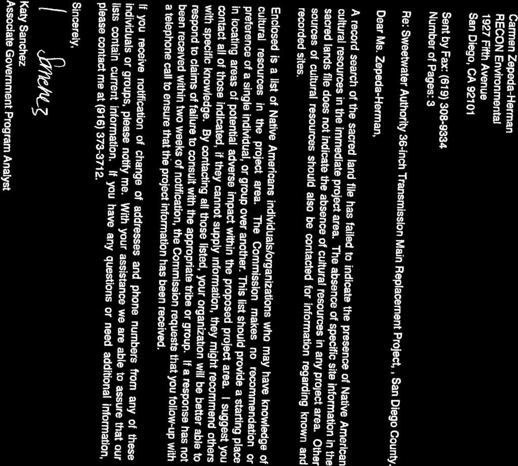
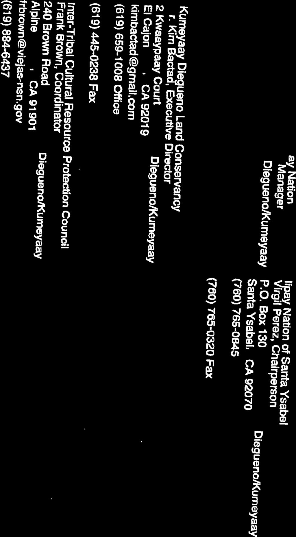
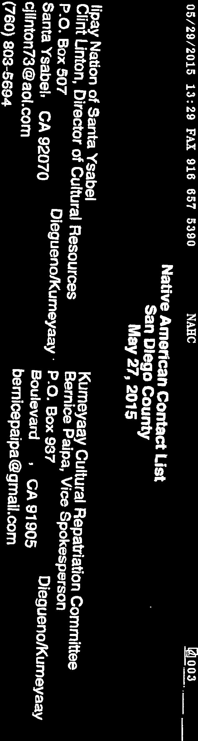
7 Mr. Luis Valdez Page 7 August 27, 2018 A letter was sent on May 8, 2015 to the NAHC requesting they search their files to identify spiritually significant and/or sacred sites or traditional use areas in the proposed project vicinity. The NAHC was also asked to provide a list of local Native American tribes, bands, or individuals who may have concerns or interests in the cultural resources of the proposed project (Attachment 1). The field survey for Segments 1 through 4 was conducted on May 14, 2015 by RECON archaeologists Carmen Zepeda-Herman and Nathanial Yerka accompanied by Tushon Phoenix, a Native American monitor from Red Tail Monitoring and Research. The spacing between field personnel was 3 to 5 meters. The survey area was inspected for evidence of archaeological materials such as flaked and ground stone tools, ceramics, milling features, and historic features. Photographs were taken to document the environmental setting and general conditions. An additional field survey was conducted for Segment 5 on September 8, 2015 by RECON archaeologist Nathanial Yerka. A 5-meter buffer area from centerline of alignment was surveyed which included wetlands associated with the Sweetwater River. Archival Results The record search indicated that there have been 73 archaeological investigations and 23 cultural resources within a half-mile radius of the APE (Attachment 2). There were 59 historic addresses listed within the search area. Thirteen prehistoric sites, seven historic sites, two prehistoric isolated artifacts, and two multicomponent sites with both prehistoric and historic components have been recorded within the search area. Four cultural resources are within or immediately adjacent to the proposed project area. CA-SDI was recorded as a lithic and ground stone artifact scatter consisting of manos, flakes, flake tools, and cores in 1989 (Rosen et al. 1989a). This site is mapped immediately adjacent to the APE. Construction of SR-125 has impacted this site and most likely destroyed it. CA-SDI was recorded as a lithic and ground stone artifact scatter consisting of flakes, cores, hammerstones, flake tools, and one mano (Rosen et al. 1989b). This site is mapped adjacent to one of the proposed staging areas. P consists of the footings for the National City and Otay Railroad trestle over the Sweetwater Valley after the 1916 flood washed away the bridge and tracks. The footings are constructed of granite porphyry extracted from the Sweetwater Quarry (Carrico 1990). This site is mapped within the APE. Isolate P was recorded as a flake within Segment 4 (Shultz et al 1992). The 1953 historic aerial photograph shows the survey area as being undeveloped, with agricultural fields and some associated buildings; the Bonita Road and Sweetwater Road crossings over the river were already built. Construction of the Chula Vista Golf Course was noted in the 1968 aerial photograph while construction of the Bonita Golf Club was noted in the 1981 aerial photograph (Nationwide Environmental Title Research 2015). The NAHC reply letter was received May 29, 2015 indicating the NAHC files failed to indicate the presence of Native American cultural resources in the immediate project area (Attachment 3). The NAHC recommends that early consultation with Native American tribes is the best way to avoid unanticipated discoveries. Contact letters to the listed individuals and groups were sent out on June 3, 2015 (Attachment 4). Survey Results One site was relocated and one non-cultural site was identified during the survey. No new cultural resources were identified. Site CA-SDI was relocated during the survey. The site boundary is located adjacent to the easternmost staging area near Segment 4. One core and an assayed cobble were identified towards to the top of a north-facing slope within the recorded site boundary and approximately 150 meters south of the proposed staging area. Ground visibility was 10 to 20 percent in this area and, therefore, there is a possibility that more artifacts are scattered within site boundary.
8 Mr. Luis Valdez Page 8 August 27, 2018 For Segment 4, ground visibility along the trail within the Bonita Golf Club was 100 percent. Road gravel, small concrete chunks, and glass fragments were noted within the trail. Towards the eastern end of the southern section of the trail, soil has been stockpiled and appears to have been brought from an off-site source. No cultural material was noted in the stockpiled soil. The footings for the National City and Otay Railroad trestle, recorded as P , were searched for under the Sunnyside Bridge. No evidence of these could be found. It is assumed that the upgrade construction of the bridge in 1999 removed the footings. The non-cultural site was identified in Segment 4 in an area that appeared to be covered with imported soil during the construction of the bridge or the building of the access road from San Miguel Road to the Bonita Golf Club. A shellfish scatter of moderate density was noted in the soils. Shellfish species included Chione spp. and Tivella spp. The 1953 aerial photograph shows a narrower bridge in the same alignment as the current Sunnyside Bridge and the location of the non-cultural site as being a small knoll near the flow of the Sweetwater River (Nationwide Environmental Title Research, LLC 2015). The knoll has been impacted since The soil with the shell scatter appeared to have been pushed up towards the access road from San Miguel Road and to clear the east-west path that runs along the southern border of the Bonita Golf Club and continues west under the Sunnyside Bridge into Sweetwater Regional Park. No new cultural resources were noted within the APE. The entire APE has been impacted by previous grading for the perimeter trail and contouring and landscaping of the Bonita Golf Club (Segment 4), for contouring and landscaping in the Chula Vista Golf Course (Segment 3), for the construction of Bonita Road (Segments 1 and 2), and for construction of the paved parking lot of the Kaiser Permanente Medical Office. No cultural material was noted within Chula Vista Golf portion of Segment 3. Ground visibility was poor due to the turf that covers the new alignment route on tee box for the first hole and driving range near the tenth hole. No cultural material was noted in the westernmost staging area near Segment 1. A portion is covered in road gravel for the parking lot and a portion has short non-native vegetation. Ground visibility was 50 percent. No cultural resources were noted along Segment 5. This alignment area is disturbed due to previous agriculture use, grading, and construction for the Kaiser Permanente Medical Office paved parking lot, the decorative planter along Willow Street, and the fully paved Willow Street and Bonita Road. The Sweetwater River open space has patches of dense vegetation with thick surface duff, which yield low ground visibility. The closest recorded resource, approximately 50 feet from project centerline, is the Willow Street Bridge which crosses the Sweetwater River between Bonita Road and Sweetwater Road. This bridge was built in 1940 and is scheduled for replacement by the City of Chula Vista. Recommendations As stated above, according to CEQA, a significant impact is a project effect that may cause a substantial adverse change in the significance of a historical resource. Adverse changes include physical demolition, destruction, relocation, or alteration of the resource or its immediate surroundings resulting in the impairment of the resource s significance (Section b, CEQA Guidelines). Mitigation measures are required for adverse effects on significant historical resources (PRC Section ). Although no cultural resources were recorded during the survey or archival review, the potential exists for encountering cultural resources during excavation activities within areas where the main will be realigned. Because of the project alignment s proximity to the Sweetwater River, a good water source for prehistoric people, the possibility of significant buried cultural resources being present is considered high. For this reason, RECON recommends the presence of qualified archaeological and Native American monitors during trenching of the new main for portions of three alignments in Segments 3, 4, and 5 that are not adjacent to the existing pipelines (Figure 4). The frequency of inspections will be determined by the Project Archaeologist in consultation with the Native American monitor and will vary based on the rate of excavation, the materials excavated, and the presence and abundance of artifacts and features.


9 Image source: Nearmap (flown February 2018) PARAD IS V U 54 E VA LL EY W O OD V U 125 SW EE TW AN ER M AT MIG S AN UEL Segment 4 V U 54 T CE N RAL AN TO N AW VA LLEY DA CO RR AL CA NY ON Segment 3 O RE Segment 5 W IL L O EETWATE R W 0 Project Alignment Feet 1,500 [ Potential Staging Area Areas to be Monitored FIGURE 4 Areas to be Monitored M:\JOBS4\7729\common_gis\2018_Arc\fig4.mxd 5/10/2018 fmm
10 Mr. Luis Valdez Page 10 August 27, 2018 In the event that unknown cultural resources or significant features are encountered during construction monitoring, the archaeological and Native American monitors will be authorized to temporarily divert trenching in the area of discovery until the significance and the appropriate mitigation measures are determined. To mitigate potential impacts to significant cultural resources, a Research Design and Data Recovery Program should be prepared by the Principal Investigator, approved by the County Archaeologist, and implemented using professional archaeological methods. Construction activities would be allowed to resume after the completion of the recovery of an adequate sample and the recordation of features. All cultural material collected during the monitoring and data recovery program shall be processed and curated at a San Diego facility that meets federal standards per Code of Federal Regulations Title 36 Part 79. After the completion of the monitoring, an appropriate report shall be prepared. If no significant cultural resources are discovered, a brief letter shall be prepared. If significant cultural resources are discovered, a report with the results of the monitoring and data recovery (including the interpretation of the data within the research context) shall be prepared. If human remains are discovered, work shall halt in that area and the procedures set forth in the California PRC (Section ) and State Health and Safety Code (Section ) will be followed. The Principal Investigator shall contact the County Coroner. Sincerely, Carmen Zepeda-Herman Project Archaeologist CZH:jg Enclosures References Cited Carrico, Richard 1995 Site Form for P On file at the South Coastal Information Center, San Diego State University. Nationwide Environmental Title Research, LLC (NETR) 2015 Historic Aerials. Accessed on May 21, Rosen, Marty, Joyce Corum, Don Laylander, Alan Willis, Marilyn Colombo, and Terry Cirilo 1989a Site Form for CA-SDI On file at the South Coastal Information Center, San Diego State University. 1989b Site Form for CA-SDI On file at the South Coastal Information Center, San Diego State University. Shultz, R.D., J. Whitehouse, and T. Gross 1992 Site Form for P On file at the South Coastal Information Center, San Diego State University.
11 ATTACHMENTS
12 ATTACHMENT 1
13 Sacred Lands File & Native American Contacts List Request NATIVE AMERICAN HERITAGE COMMISSION 915 Capitol Mall, RM 364 Sacramento, CA (916) (916) Fax Information Below is Required for a Sacred Lands File Search Project: Sweetwater Authority 36-inch Transmission Main Replacement Project County: San Diego County USGS Quadrangle Name: National City Township: 17 South Range: 2 West/1 West Section(s): Unsectioned Portion of La Nacion landgrant Contact Information Company/Firm/Agency: RECON Environmental Contact: Carmen Zepeda-Herman Street Address: 1927 Fifth Avenue City: San Diego ZIP: Phone: Fax: czepeda@reconenvironmental.com Project Description: The proposed project will replace sections of the existing 36-inch diameter treated water transmission main between an area just west of Interstate 805 and State Route 125 in the Sweetwater River Valley, Bonita, California. The majority of the 18,000 feet of pipeline to be replaced will be replaced with a 36- inch pipeline with a 5,000-foot reach of pipeline to be upsized to 48-inches as required to improve service. The construction of the transmission main will occur over public right-of-way on Bonita Road and easements and will affect two golf courses. The parking lot and a portion of the Chula Vista Golf Course amd the southern portion and the trail along the southern and eastern perimeter of the Bonita Golf Course will be impacted.
14 ATTACHMENT 2


15
16 ATTACHMENT 3


17

18

19
20 ATTACHMENT 4
21 1927 Fifth Avenue 2033 East Grant Road 5951 Encina Road, Suite 104 San Diego, CA Tucson, AZ Goleta, CA P P P F F An Employee-Owned Company June 3, 2015 Mr. Frank Brown Viejas Kumeyaay Indian Reservation 240 Brown Road Alpine, CA Reference: Sweetwater Authority 36-Inch Transmission Main Replacement (RECON Number 7729) Dear Mr. Brown: RECON Environmental, Inc. has been retained by the Sweetwater Authority to conduct an archaeological survey for the 36-inch Transmission Main Replacement. The project is located in Bonita Valley, from just west of Interstate 805 to State Route 125 (SR-125), within portions of the city of Chula Vista and the unincorporated community of Bonita. The project alignment is composed of four segments, primarily along Bonita Road, but also within portions of the Chula Vista Golf Course and the Bonita Golf Club. The 36-inch transmission main replacement involves the installation of approximately 20,000 linear feet of pipeline. In most cases, the replacement pipelines would be installed within the same trench and at approximately the same depth as the existing pipelines, using the open cut trench method. The proposed project would also include the abandonment of segments of the existing water main in several locations where the transmission main will be realigned. The project is within the La Nación land grant in Township 17 South, Ranges 1 and 2 West, of the U.S. Geographical Survey 7.5-minute topographic map National City quadrangle (see attached figure). A letter requesting identification of spiritually significant and sacred sites or traditional use areas in the proposed project vicinity was sent to the Native American Heritage Commission (NAHC). No Native American cultural resources were identified in the immediate project area. A record search was conducted of the archaeological databases maintained at the California Historical Resources Information System, South Coastal Information Center (SCIC) at San Diego State University. The files at SCIC identified two prehistoric archaeological sites, one prehistoric isolated artifact, and one historic site recorded within or immediately adjacent to the proposed project area. CA-SDI and CA-SDI were recorded as lithic and ground stone artifact scatters. Construction of SR-125 has impacted CA-SDI and most likely destroyed it. Isolate P was recorded as a flake. P consists of the footings for the National City and Otay Railroad trestle over the Sweetwater Valley after the 1916 flood washed away the bridge and tracks. This site is mapped within the project area. It is assumed that the construction of the replacement bridge removed the footings in 1999.
22 Mr. Frank Brown Page 2 June 3, 2015 One site and one non-cultural site were identified during the survey. No new cultural resources were identified. Site CA-SDI was relocated during the survey. This site will be avoided during construction and the area near it will be monitored. The non-cultural site was identified in an area that appeared to be covered with imported soil during the construction of the bridge or the building of the access road from San Miguel Road to the Bonita Golf Club. A shellfish scatter of moderate density was noted in the soils. Pursuant to the letter received in response from Katy Sanchez of the NAHC, we are contacting you as a potentially interested party. We would like to know if you have any concerns regarding the proposed project as it relates to Native American issues or interests. Would you have any information on sacred sites in the vicinity of the proposed project that may help us advise the client to avoid impacts to these sites? We would like to obtain Native American input early enough in the environmental process to ensure adequate time to address any concerns you may have. We would also appreciate any referrals to another tribe or person knowledgeable about the cultural resources within or adjacent to the proposed project area that may be of help in the planning process with regard to Native American concerns. Please feel free to contact me if you have questions, comments, or concerns. If we have not heard from you by June 19, 2015, we will assume that you have no comments. Thank you for your assistance. Sincerely, Carmen Zepeda-Herman Project Archaeologist CZH:jg Enclosure
Cultural Resource Management Report Deer Valley 4wd Restoration and Blue Lakes Road Maintenance Project R
 Cultural Resource Management Report R2015-05-03-10005 Undertaking Description: The proposes to perform road maintenance and meadow restoration on the Deer Valley 4wd trail and road maintenance on the Blue
Auditor s Apportionment Spreadsheet
 APPORTIONMENT of San Diego LAFCO NET OPERATING COST Auditor s Apportionment Spreadsheet General Cities class 1 1. City of Carlsbad $117,089,256 $117,695,090 $ 64,511 $ 62,032 (2,479) 2. City of Chula Vista
Fire, Brush, and Building Information for Municipalities and Fire Protection Districts in the County of San Diego
 in the Alpine Alpine Fire Protection District 1364 Tavern Road Alpine, CA 91901-2107 (619) 445-2635 http://www.alpinefire.org Bonita / Sunnyside Bonita - Sunnyside Fire Protection District 4900 Bonita
DRAFT. Dorabelle Campground Rehabilitation
 DRAFT Dorabelle Campground Rehabilitation September 2012 1.1 REGIONAL SETTING AND PROJECT LOCATION The Dorabelle Campground is located on the western shore of Shaver Lake in Fresno County, California (Section
Full County 2013 REPORT
 North San Diego Association of REALTORS $ North San Diego HomeDex TM Full REPORT Statistics HomeDex is an exclusive NSDCAR member benefit PLEASE READ The name HomeDex and its contents are protected under
SAN DIEGO, CALIFORNIA
 SAN DIEGO, CALIFORNIA SAN DIEGO HOME OF THE GOOD LIFE San Diego is the eighth largest city in the U.S. and second largest in California. Fashion Valley boasts the city s finest collection of premium retail
This section evaluates the projected traffic operations and circulation impacts associated with the proposed upgrade and expansion of the LWRP.
 4.5 TRAFFIC AND CIRCULATION This section evaluates the projected traffic operations and circulation impacts associated with the proposed upgrade and expansion of the LWRP. 4.5.1 Environmental Setting Existing
NOVEMBER San Diego County Summary Statistics
 Copyright 2017 Greater San Diego Association of REALTORS. Data for single-family detached and attached home sales through the Multiple Listing Service of Sandicor, Inc. Neither SDAR nor Sandicor guarantees
VISTA AZUL- APPROVED 20 LOT TENTATIVE MAP
 Expansive Views Entitlements for 20 Residential Lots Previously Graded Entitled for 14 Detached Lots, 6 Townhome Units DOWNTOWN SAN DIEGO ASKING PRICE: $1,395,000 - OFFERS DUE JULY 14, 2017 Monterey Heights
White Mountain National Forest Saco Ranger District
 United States Department of Agriculture Forest Service White Mountain National Forest 33 Kancamagus Highway Conway, NH 03818 Comm: (603) 447-5448 TTY: (603) 447-3121 File Code: 1950 Date: February 26,
10926 W OOD SI D E AV E N.
 10926 W OOD SI D E AV E N. SANTEE, CA 92071 F OR SALE OR APPROXIMATELY 91,923 SF STATE OF THE ART INDUSTRIAL / MANUFACTURING BUILDING OWNER USER / INVESTMENT OPPORTUNITY APPROXIMATELY 91,923 SF STATE OF
United States Department of the Interior National Park Service. Boundary Expansion Listed in National Register January 11, 2017
 NPS Form 10900-a (Rev. 8/2002) OMB No. 10240018 United States Department of the Interior National Park Service Boundary Expansion Listed in National Register January 11, 2017 National Register of Historic
San Marcos. Escondido. Lake San Marcos. !"a$ Lake Hodges. Poway. San Diego Bay. Miramar Reservoir. Santee. Lake Jennings La Jolla?
 ORNGE COUNTY RIVERSIDE COUNTY SN DIEGO COUNTY Vail O'Neill Camp Pendleton "^$ Oceanside Vista Fallbrook Ä WÛ Wohlford Henshaw ª Warner Springs I:\PROJECTS\P\PDW\PDW-0._MastPlan_PEIR\Map\NOP\Fig_Regional.mxd
San Diego County. The San Diego County Courthouse. Part 1 of 6: San Diego.
 San Diego County The San Diego County Courthouse. Part 1 of 6: San Diego. San Diego County San Diego County Data Population: 2,813,833 ( Rank: 3) Land Area (square miles): 4,200 (Rank: 9) The hills that
EAST VALLEY PARKWAY FOR SALE - RESIDENTIAL DEVELOPMENT OPPORTUNITY 3141 E. VALLEY PARKWAY ESCONDIDO, CA ACRE SITE $1,100,000
 3141 E. VALLEY PARKWAY ESCONDIDO, CA 92027-5219 3.31 ACRE SITE $1,100,000 OFFERING HIGHLIGHTS Valley High School Residential Development Opportunity Close to Frances Ryan Park & Multiple Schools Settled
PREMIER CARDIFF DEVELOPMENT OPPORTUNITY 17.5 GROSS ACRES
 Views / Ocean Views from Top Portion of Site Zoned RR-2 (21,500 SF Minimum Lot Size) City of Encinitas Jurisdiction One of the Last Premier Undeveloped Large Parcels of Land in San Diego County Submit
Rule Governing the Designation and Establishment of All-Terrain Vehicle Use Trails on State Land
 Rule Governing the Designation and Establishment of All-Terrain Vehicle Use Trails on State Land 1.0 Authority 1.1 This rule is promulgated pursuant to 23 V.S.A. 3506. Section 3506 (b)(4) states that an
FOR SALE. *Do Not Disturb Tenants El Cajon Blvd San Diego, CA ,061 SF RETAIL INVESTMENT/OWNER-USER OPPORTUNITY $2,000,000 ($492/SF)
") 4427-4433 El Cajon Blvd San Diego, CA 92115 $2,000,000 ($492/SF) 6.% CAP OR VACANT FOR OWNER/USER *Do Not Disturb Tenants KIPP GSTETTENBAUER Senior Vice President RYAN KING Vice President 5.45.3345 kipp@voitco.com
4427-4433 El Cajon Blvd San Diego, CA 92115 $2,000,000 ($492/SF) 6.% CAP OR VACANT FOR OWNER/USER *Do Not Disturb Tenants KIPP GSTETTENBAUER Senior Vice President RYAN KING Vice President 5.45.3345 kipp@voitco.com
Original Report F WIN , F WIN Prepared for Northland Power and Ministry of Tourism and Culture
 STAGE 2 ARCHAEOLOGICAL ASSESSMENT McLEAN S MOUNTAIN WIND FARM Part Lots 12-15, Concession 3 Geographic Township of Howland Part Lot 24, Concession 12 Geographic Township of Bidwell and Goat Island (formerly
2018 Firefighter Boot Drive Locations Thursday, March 1
 2018 Firefighter Boot Drive Locations Thursday, March 1 Alpine Fire Protection District Alpine Boulevard & S. Grade Road Harbison Canyon & Arnold Way Tavern Road & Alpine Boulevard Barona Fire Department
SANDAG s Regional Transportation Plan
 SANDAG s Regional Transportation Plan Oceanside 5 Camp Pendleton Carlsbad P A C C I I F I C C O O C C E E A A N N 472 398 76 Encinitas 399 78 Solana Beach 472 Vista 15 San Marcos 399 399 470 610 Escondido
Annual Report on the North San Diego County Housing Market RESIDENTIAL REAL ESTATE ACTIVITY IN NORTH SAN DIEGO COUNTY
 Annual Report on the North San Diego County Housing Market RESIDENTIAL REAL ESTATE ACTIVITY IN NORTH SAN DIEGO COUNTY RESIDENTIAL REAL ESTATE ACTIVITY IN NORTH SAN DIEGO COUNTY There is an ongoing and
Bradley Brook Relocation Project. Scoping Notice. Saco Ranger District. United States Department of Agriculture Forest Service
 Bradley Brook Relocation Project United States Department of Agriculture Forest Service Scoping Notice White Mountain National Forest February 2011 For Information Contact: Jenny Burnett White Mountain
Appendix F Cultural Resource Consultation
 Appendix F Cultural Resource Consultation FAA Consultation Letter to the California State Historic Preservation Officer Response Letter from the California State Historic Preservation Officer STATE
Wilderness Areas Designated by the White Pine County bill
 Wilderness Areas Designated by the White Pine County bill SEC. 321. SHORT TITLE. This subtitle may be cited as the `Pam White Wilderness Act of 2006'. SEC. 322. FINDINGS. Congress finds that-- The White
ROAD AND TRAIL PROJECT APPROVAL
 ROAD AND TRAIL PROJECT APPROVAL www.marincountyparks.org Marin County Parks, 3501 Civic Center Dr, Suite 260, San Rafael, CA 94903 DATE: July 12, 2017 PRESERVE: Gary Giacomini Open Space Preserve PROJECT:
STAFF REPORT. Airport Land Use Plan Consistency Review: Old Town Village Mixed Use Project City of Goleta. MEETING DATE: June 18, 2015 AGENDA ITEM: 5M
 STAFF REPORT SUBJECT: Airport Land Use Plan Consistency Review: Old Town Village Mixed Use Project City of Goleta MEETING DATE: AGENDA ITEM: 5M STAFF CONTACT: Peter Imhof, Andrew Orfila RECOMMENDATION:
CITY OF PALMDALE. REPORT to the Mayor and Members of the City Council from the City Manager
 CITY OF PALMDALE REPORT to the Mayor and Members of the City Council from the City Manager DATE: June 4, 2014 SUBJECT: Specific Plan Amendment 14-01; Amending the Use Designation of 23.97 Acres within
STATE OF WASHINGTON ARCHAEOLOGICAL SITE INVENTORY FORM
 STATE OF WASHINGTON ARCHAEOLOGICAL SITE INVENTORY FORM Smithsonian Number: 45 County: Chelan Date: 6/12/2018 Human Remains? DAHP Case No.: Archaeological Sites are exempt from public disclosure per RCW
LOCATED IN THE PRESTIGIOUS CARLSBAD RESEARCH CENTER
 2258 Rutherford Road Carlsbad, CA LOCATED IN THE PRESTIGIOUS CARLSBAD RESEARCH CENTER HENRY ZAHNER Lic. #00887367 760.889.7943 hzahner@voitco.com RICKY JAMES Lic. #01984985 951.322.0082 rjames@voitco.com
Twin Oaks Valley Rd Windy Way
 & Twin Oaks Valley Rd Windy Way NE Corner of Twin Oaks Valley Rd & Windy Way San Marcos, CA 92069 TUCKER HOHENSTEIN, SIOR +1 760 930 7966 tucker.hohenstein@colliers.com JOHN WITHERALL +1 760 930 7927 john.witherall@colliers.com
New Class "A" 530,850 SF 2-Building Infill Logistics/ Distribution Development
 14400-14500 KIRKHAM WAY POWAY, CA 92064 New Class "A" 530,850 SF 2-Building Infill Logistics/ Distribution Development DEVELOPMENT OF REPRESENTED BY Mickey Morera 858.369.3030 mmorerea@kiddermathews.com
Appendix L Technical Memorandum Aesthetics
 Technical Memorandum Aesthetics 1.0 AESTHETICS This section provides a discussion of the aesthetic resources in the vicinity of ARTIC. Aesthetics pertain to the elements that make a certain view pleasing
STAFF REPORT. Airport Land Use Consistency Determination Betteravia Plaza. MEETING DATE: January 21, 2016 AGENDA ITEM: 8D
 STAFF REPORT SUBJECT: Airport Land Use Consistency Determination Betteravia Plaza MEETING DATE: AGENDA ITEM: 8D STAFF CONTACT: Andrew Orfila RECOMMENDATION: Adopt findings for the Betteravia Plaza project
SUMMER VILLAGE OF SILVER SANDS. Municipal Development Plan
 SUMMER VILLAGE OF SILVER SANDS Municipal Development Plan Bylaw 253-2014 Adopted August 22, 2014 Summer Village of Silver Sands Municipal Development Plan Bylaw No. 253-2014 Page 2 1 INTRODUCTION 1.1 SETTING
Decision Memo for Desolation Trail: Mill D to Desolation Lake Trail Relocation
 for Salt Lake County, Utah Uinta-Wasatch-Cache National Forest Salt Lake Ranger District 1. Background The present location of the Desolation Trail (#1159) between Mill D and Desolation Lake follows old
Rappahannock River Crossing Project; Ms. J. V. Langan; May 28, 2015 Page 2 of 6
 Page 2 of 6 VDOT engaged the consultant firm McCormick Taylor to conduct the historical research and Phase I and Phase II field investigations necessary to identify and assess the significance of archaeological
$10,900,000 or Potential J.V., Seller Financing, Take Downs, etc. Available
 $10,900,000 or Potential J.V., Seller Financing, Take Downs, etc. Available 451.50 gross acres Lots from 1.7-93.50 acres Ocean views Shown by Appointment ONLY subject property Escondido Escondido Lee &
The following criteria shall be applied within the boundaries of the AO District:
 Sec. 419 (a) Purpose AIRPORT OVERLAY DISTRICT (AO) The purpose of the Airport Overlay District is to regulate and restrict the height of structures, objects, or natural growth, regulate the locations of
Area of Potential Effect Report
 Area of Potential Effect Report Southeastern Pennsylvania Transportation Authority (SEPTA) King of Prussia Rail, Extension of the Norristown High Speed Line Upper Merion Township, Montgomery County, and
Tahquitz Canyon Data Recovery Project
 http://oac.cdlib.org/findaid/ark:/13030/kt500037fc No online items Agua Caliente Cultural Museum 901 E Tahquitz Canyon Way Ste C-204 Palm Springs, California 92262 Phone: (760) 778-1079 Fax: (760) 322-7724
Renovations Under Way! See Pg. 3 for more details.
 FOR LEASE > ±48,326 SF INDUSTRIAL MANUFACTURING FACILITY Renovations Under Way! See Pg. 3 for more details. 10605SPRING VALLEY CA Jamacha Blvd Tucker Hohenstein, SIOR +1 760 930 7966 tucker.hohenstein@colliers.com
APPENDIX I STANDARD CONSULTATION PROTOCOL FOR TRAVEL MANAGEMENT ROUTE DESIGNATION
 APPENDIX I STANDARD CONSULTATION PROTOCOL FOR TRAVEL MANAGEMENT ROUTE DESIGNATION Developed Pursuant to Stipulation IV.A. of the Region 3 First Amended Programmatic Agreement Regarding Historic Property
C. APPROACH FOR IDENTIFYING THE BEST ROUTES FOR THE NEEDED TRANSMISSION SYSTEM IMPROVEMENTS
 C. APPROACH FOR IDENTIFYING THE BEST ROUTES FOR THE NEEDED TRANSMISSION SYSTEM IMPROVEMENTS CL&P s approach for identifying the best routes for the needed transmission system improvements included a determination
CHAPTER 1 INTRODUCTION MORENO VALLEY GENERAL PLAN 1. INTRODUCTION. 1.1 What is a General Plan?
 1. INTRODUCTION 1.1 What is a General Plan? A General Plan is a comprehensive long-term strategy for the physical development of a city. It determines how land may be used and the infrastructure and public
Accelerating Success. PCD. FOR LEASE Vista, CA ±157,176 SF FREESTANDING INDUSTRIAL ANOTHER QUALITY PROJECT BY:
 1 3 9 5 PCD P A R K C E N T E R D R I V E Accelerating Success. www.1395parkcenterdrive.com ANOTHER QUALITY PROJECT BY: Property Features LOCATION Prominent corner of Carlsbad/Vista Signalized intersection
AN ARCHAEOLOGICAL ASSESSMENT OF BOERNE CITY PARK, KENDALL COUNTY, TEXAS. Thomas C. Kelly and Thomas R. Hester
 AN ARCHAEOLOGICAL ASSESSMENT OF BOERNE CITY PARK, KENDALL COUNTY, TEXAS Thomas C. Kelly and Thomas R. Hester Center for Archaeological Research The University of Texas at San Antonio Archaeological Survey
Owned and Managed By:
 Conor Boyle +1 760 930 7967 conor.boyle@colliers.com License No. 01813305 Tucker Hohenstein, SIOR +1 760 930 7966 tucker.hohenstein@colliers.com License No. 00999360 Tyler Stemley +1 760 930 7929 tyler.stemley@colliers.com
David Magney Environmental Consulting
 David Magney Environmental Consulting DELINEATION OF JURISDICTIONAL WATERS AND RIPARIAN HABITATS FOR LYONS CANYON RANCH, NEWHALL, CALIFORNIA Prepared for: UNITED STATES ARMY CORPS OF ENGINEERS and CALIFORNIA
Section 3.6 Recreation
 3.6 RECREATION This section evaluates the potential impacts of the proposed project on recreation within MTRP. The evaluation is based on field observations, a review of maps of MTRP and the MTRP Master
2.0 Physical Characteristics
 _ 2.0 Physical Characteristics 2.1 Existing Land Use for the Project The site is comprised of approximately 114 acres bounded by Highway 101 to the north, the existing town of Los Alamos to the east, State
Public Notice ISSUED: December 10, 2018 EXPIRES: January 9, 2019
 APPLICANT: REFER TO: St. Louis and Lake Counties Regional Rail Authority 2018-01942-ARC Public Notice ISSUED: December 10, 2018 EXPIRES: January 9, 2019 SECTION:404 - Clean Water Act 1. APPLICATION FOR
CARLSBAD PREMIUM OUTLETS
 CARLSBAD PREMIUM OUTLETS THE SIMON EXPERIENCE WHERE BRANDS & COMMUNITIES COME TOGETHER More than real estate, we are a company of experiences. For our guests, we provide distinctive shopping, dining and
St. Joe Travel Management EA CULTURAL RESOURCES
 St. Joe Travel Management EA CULTURAL RESOURCES Bruce Gibson May 2015 Regulatory Framework Forest Plan The Idaho Panhandle National Forests (IPNF) Forest Plan requires systematic cultural resource inventory
1803 West Hwy 160 Monte Vista, CO (719) TTY (719)
 TTY (719)") USDA Forest Service Rio Grande National Forest http://www.fs.fed.us/r2/riogrande 1803 West Hwy 160 Monte Vista, CO 81144 (719)852-5941 TTY (719)852-6271 USDI Bureau of Land Management San Luis Valley Center
USDA Forest Service Rio Grande National Forest http://www.fs.fed.us/r2/riogrande 1803 West Hwy 160 Monte Vista, CO 81144 (719)852-5941 TTY (719)852-6271 USDI Bureau of Land Management San Luis Valley Center
Decision Memo Broken Wheel Ranch Equestrian Outfitter Special-Use Permit Proposed Action
 Decision Memo Broken Wheel Ranch Equestrian Outfitter Special-Use Permit USDA Forest Service Mississippi Bluffs Ranger District, Shawnee National Forest Jackson and Union Counties, Illinois Proposed Action
Executive Directors Report
 SAN DIEGUITO RIVER PARK JOINT POWERS AUTHORITY 9:30 a.m. 12:00 p.m. Friday, July 18, 2014 County Administration Center 1600 Pacific Highway, Room 302/303 San Diego Speaker slips will be available. Please
Section 106 Update Memo #1 Attachment D. Traffic Diversion & APE Expansion Methodology & Maps
 Section 106 Update Memo #1 Attachment D Traffic Diversion & APE Expansion Methodology & Maps I-65/I-70 North Split Interchange Reconstruction Project (Des. Nos. 1592385 & 1600808) Traffic Diversion and
AN URGENCY ORDINANCE OF THE COUNTY OF BUTTE CAMP FIRE DISASTER RECOVERY TEMPORARY HOUSING ORDINANCE: 4/5 VOTE REQUIRED
 1 2 Ordinance No. 0 AN URGENCY ORDINANCE OF THE COUNTY OF BUTTE CAMP FIRE DISASTER RECOVERY TEMPORARY HOUSING ORDINANCE: / VOTE REQUIRED The Board of Supervisors of the County of Butte ordains as 7 follows:
FOR SALE. Excellent Owner-User Opportunity El Cajon Blvd San Diego, CA 92115
 FOR SALE Excellent Owner-User Opportunity 6602 El Cajon Blvd San Diego, CA 92115 2aCG 2
White Mountain National Forest Saco Ranger District
 United States Department of Agriculture Forest Service White Mountain National Forest Saco Ranger District 33 Kancamagus Highway Conway, NH 03818 Comm: (603) 447-5448 TTY: (603) 447-3121 File Code: 1950
EXECUTIVE SUMMARY PROGRAM DEVELOPMENT REPORT PURPOSE EXISTING SETTING EXPANDING PARKLAND
 EXECUTIVE SUMMARY PROGRAM DEVELOPMENT REPORT PURPOSE As the culmination of the first phase of the master planning process, this Program Development Report creates the framework to develop the Calero County
DE LA PLATA OCEANSIDE, CA
 4128 INVESTMENT OR OWNER/USER OPPORTUNITY AT RANCHO DEL ORO TECHNOLOGY PARK AVENIDA DE LA PLATA HENRY ZAHNER 760.889.7943 hzahner@voitco.com Lic. #00887367 RICKY JAMES 951.322.0082 rjames@voitco.com Lic.
THE ALBERTA GAZETTE, SEPTEMBER
 VILLAGE OF CEREAL Order No. 16915 IN THE MATTER OF THE "Municipal Government Act": File No. 241(A)3 AND IN THE MATTER OF an application by the Council of the Village of Cereal, in the Province of Alberta,
Table 1: Avocado Flats Communication Site. Latitude 1 Longitude 1 Elev 2 Address T/R/S 3 APN 4 USGS Quadrangle
 County of Riverside Public Safety Enterprise Communication Project Appendix A: Candidate Site Descriptions Overview The candidate area is located in Northern San Diego County, 0.65 mile south of the border
Carlsbad Pacific Center
 CLASS A OFFICE ON-SITE AMENITIES PROMINENT LOCATION HIGHLY FLEXIBLE FLOOR PLATES Carlsbad Pacific Center 701, 703 & 705 PALOMAR AIRPORT ROAD CARLSBAD, CA 92011 VENTANA 2173, 2175 & 2177 SALK AVENUE, CARLSBAD,
COASTAL CONSERVANCY. Staff Recommendation September 22, 2011 BAY AREA RIDGE TRAIL: HOOD MOUNTAIN TO HIGHWAY 12
 COASTAL CONSERVANCY Staff Recommendation September 22, 2011 BAY AREA RIDGE TRAIL: HOOD MOUNTAIN TO HIGHWAY 12 File No. 11-039-001 Project Manager: Betsy Wilson RECOMMENDED ACTION: Authorization to disburse
COASTAL CONSERVANCY. Staff Recommendation December 2, 2004 COYOTE HELLYER COUNTY PARK BAY AREA RIDGE TRAIL
 COASTAL CONSERVANCY Staff Recommendation December 2, 2004 COYOTE HELLYER COUNTY PARK BAY AREA RIDGE TRAIL File No. 04-057 Project Manager: Amy Hutzel RECOMMENDED ACTION: Authorization to disburse up to
RIO VISTA MUNICIPAL AIRPORT
 DRAINAGE TECHNICAL MEMORANDUM RIO VISTA MUNICIPAL AIRPORT RIO VISTA, CALIFORNIA Prepared for: City of Rio Vista 1 Main Street Rio Vista, CA 94571 (707) 374-5337 Prepared by: August 2012 Copyright 2012
Table 1: Black Eagle Communication Site. Latitude 1 Longitude 1 Elev 2 Address T/R/S 3 APN 4 USGS Quadrangle
 County of Riverside Public Safety Enterprise Communication Project Appendix A: Candidate Site Descriptions Overview The site is located on a previously graded and benched plateau within the Black Eagle
Access to the site is obtainable from the paved driveway leading to the MWD facility.
 County of Riverside Public Safety Enterprise Communication Project Appendix A: Candidate Site Descriptions Overview The site is located adjacent to a Metropolitan Water District (MWD) facility on El Sobrante
16.34 ACRES - FREEWAY FRONTAGE - VARIOUS USES ALLOWED
 Approximately 6.5 Acres in Usable Pads Hotel or Multi-Family (1 DU/1,000 SF) Mixed Use Allowed with C.U.P. Zoning Allows Retail, Office or Senior Care Excellent Freeway Visibility SALE PRICE: $7,180,000
THE COURTYARD AT CARMEL MOUNTAIN RANCH
 THE COURTYA AT CARMEL MOUNTAIN RANCH 1,200 SF & 1,522 SF CAN BE COMBINED RANCHO CARMEL DR CARMEL MOUNTAIN 11134 RANCHO CARMEL DRIVE San Diego, CA 92128 PROJECT FEATURES fflocated at major signalized intersection
9,600 SF Multi-Tenant Retail Center INVESTMENT OPPORTUNITY
 Emerald raldld H Hill Hill Ln Ln Ln Woodside Ave 9,600 SF Multi-Tenant Retail Center INVESTMENT OPPORTUNITY Prospect Ave TABLE OF CONTENTS 04 Executive Summary 04 05 06 08 09 10 11 12 13 14 24 24 24 25
Fully Entitled 50-Acre Corporate Industrial Park. Build-to-Suits For Sale or Lease. 50,000 to 2,000,000 SF
 Fully Entitled 50-Acre Corporate Industrial Park Build-to-Suits For Sale or Lease 50,000 to 2,000,000 SF UP TO 2,000,000 SF BUILD-TO-SUIT DEVELOPMENT FOR SALE OR LEASE 1 2 DEVELOPMENT READY 12 months to
WASHINGTON STATE PARKS AND RECREATION COMMISSION POLICY/PROCEDURE
 WASHINGTON STATE PARKS AND RECREATION COMMISSION POLICY/PROCEDURE 65-13-1 Use of Other Power-Driven Mobility Devices by Persons with Mobility Disabilities at State Park Facilities See Also: 28 CFR 35 Title
Triangle Land Conservancy Conservation Area Monitoring Report Carolina North
 Triangle Land Conservancy Conservation Area Monitoring Report Carolina North Property Name: Bolin Creek East Conservation Area Date of visit: 4/8/2015 County: Orange Property Type: Restrictive Covenants
APPROVED TENTATIVE PARCEL MAP FOR 8 UNITS WITH EXISTING DUPLEX
 .82 Gross Acres Grossmont Union High School District 4 Duplex Building Design (One Existing 3,096 SF Duplex to Remain) Total of 8 4 Bedroom 2.5 Bath 2 Car Garage Units SALE PRICE: $1,199,000 $895,000 SUBJECT
BACKGROUND DECISION. Decision Memo Page 1 of 6
 DECISION MEMO DEVIL S ELBOW BY-PASS, BOUNDARY TRAIL NO.1 U.S. FOREST SERVICE T9N, R7E, SECTION 9 RANGE 5E COWLITZ COUNTY WA MOUNT ST. HELENS NATIONAL VOLCANIC MONUMENT, GIFFORD PINCHOT NATIONAL FOREST
FOR LEASE. ±106,412 SF Freestanding Industrial Building WAPLES CT EVAN MCDONALD TOM MERCER
 FOR LEASE ±106,412 SF Freestanding Industrial Building 10015 WAPLES CT EVAN MCDONALD +1 858 677 5339 TOM MERCER +1 858 677 5388 PROPERTY DETAILS Currently the only ±100,000 SF freestanding industrial building
ARCHAEOLOGICAL MONITORING OF THE ASHBY STREET DRAINAGE PROJECT, SAN ANTONIO, BEXAR COUNTY, TEXAS
 ARCHAEOLOGICAL MONITORING OF THE ASHBY STREET DRAINAGE PROJECT, SAN ANTONIO, BEXAR COUNTY, TEXAS Anne A. Fox and I. Waynne Cox / Center for Archaeological Research The University of Texas at San Antonio
CARLSBAD ENCINITAS LA JOLLA
 16955 Via Del Campo CARLSBAD SAN MARCOS ESCONDIDO ENCINITAS SOLANA BEACH RANCHO SANTA FE 4S RANCH SANTALUZ RANCHO BERNARDO 169 VALLEY CENTER 16955 Via Del Campo RAMONA POWAY DEL MAR Exclusive advisors
Flow Stand Up Paddle Board Parkway Plan Analysis
 Regional Parks Department Jeffrey R. Leatherman, Director County of Sacramento Divisions Administration Golf Leisure Services Maintenance Rangers Therapeutic Recreation Services Flow Stand Up Paddle Board
Attachment G STREAM IMPACTS. Ridge Road Extension Alternatives Analysis
 Attachment G STREAM IMPACTS for: Ridge Road Extension Alternatives Analysis PREPARED FOR: Pasco County Engineering Services Department PREPARED BY: NV5, INC. 6989 E. FOWLER AVENUE TAMPA, FLORIDA 33617
SIEMPRE VIVA BUSINESS PARK BUILDING 17 & 18 San Diego, California 92154
 SIEMPRE VIVA BUSINESS PARK BUILDING 17 & 18 San Diego, California 924 Manufacturing, Distribution, and Warehouse 30,000 SF - 201,020 SF Available For Sale or Lease PROJECT SUMMARY INDUSTRIAL BUILDINGS
APPENDIX F. FAA and Orange County ALUC References
 APPENDIX F FAA and Orange County ALUC References Mail Processing Center Federal Aviation Administration Southwest Regional Office Obstruction Evaluation Group 2601 Meacham Boulevard Fort Worth, TX 76193
Architectural Inventory Form
 OAHP1403 Rev. 9/98 COLORADO CULTURAL RESOURCE SURVEY Architectural Inventory Form Official eligibility determination (OAHP use only) Date Initials Determined Eligible- NR Determined Not Eligible- NR Determined
Triangle Land Conservancy Conservation Area Monitoring Report Carolina North
 Triangle Land Conservancy Conservation Area Monitoring Report Carolina North Property Name: Crow Branch Conservation Area Date of visit: 4/8/2015 County: Orange Property Type: Restrictive Covenants Local
RESIDENTIAL DEVELOPMENT OPPORTUNITY ESTATE LOT ACRES
 Subdivision Potential Based on Slope Near California State University San Marcos Zoned - Heart of the City Specific Plan (VLD - Residential) Area of $950,000 - $1,500,000+ New Homes Sale Price: $499,000
STAFF REPORT. Airport Land Use Plan Consistency Review: Santa Barbara Airport Master Plan. MEETING DATE: November 19, 2015 AGENDA ITEM: 7D
 STAFF REPORT SUBJECT: Airport Land Use Plan Consistency Review: Santa Barbara Airport Master Plan MEETING DATE: AGENDA ITEM: 7D STAFF CONTACT: Peter Imhof, Andrew Orfila RECOMMENDATION: Adopt findings
White Mountain National Forest
 White Mountain National Forest United States Department of Agriculture Forest Service Eastern Region Boles Brook Snowmobile Bridge Decision Memo Boles Brook Snowmobile Bridge Project Town of Woodstock
DIRECTIONS TO SCHOOLS
 DIRECTIONS TO SCHOOLS BELL JUNIOR HIGH 620 South Briarwood Road San Diego, CA 92139 (619) 479-7111 Take 805 South to Plaza Blvd. exit, stay in the left hand lane. Plaza turns into Paradise Valley Road;
ROUKEN GLEN: BANDSTAND 2015 DATA STRUCTURE REPORT
 ROUKEN GLEN: BANDSTAND 2015 DATA STRUCTURE REPORT Author (s) Ian Hill Editors Report Date June 2015 Working Partners Funders Phil Richardson East Renfrewshire Council East Renfrewshire Council, Heritage
EDGEHILL RANCH APPROVED 15 LOT TENTATIVE MAP W. 15TH AVENUE - ESCONDIDO, CA
 13,233 SF Average Lot Size 6.88 Acres Area of 600-800k Homes Sale Price: $995,000 - Submit all Offers W 9th Ave Redwood St Centre City Pkwy Tulip St Grace Christian School W 11th Ave Felicita Elementary
Fully Entitled 50-Acre Corporate Industrial Park. Build-to-Suits For Sale or Lease. 50,000 to 2,000,000 SF
 Fully Entitled 50-Acre Corporate Industrial Park Build-to-Suits For Sale or Lease 50,000 to 2,000,000 SF UP TO 2,000,000 SF BUILD-TO-SUIT DEVELOPMENT FOR SALE OR LEASE 1 2 DEVELOPMENT READY 12 months to
RANCHO VISTA - APPROVED 29 LOT FINAL MAP WITH BONDS POSTED
 RANCHO VISTA - APPROVED 29 LOT FINAL MAP WITH BONDS POSTED SAN DIMAS DRIVE - OCEANSIDE, CA 16.87 Gross Acres 4 Miles to the Beach Views from all Lots 3,458-6,448 SF Average Lot Sizes 2,126, 2,357, 2,462
For Lease RENOVATIONS UNDERWAY CROSTHWAITE CIRCLE, POWAY. Rare opportunity to lease a 192,629 SF industrial/r&d space in Central San Diego
 For Lease 12367 CROSTHWAITE CIRCLE, POWAY RENOVATIONS UNDERWAY Rare opportunity to lease a 192,629 SF industrial/r&d space in Central San Diego Exclusively Listed By KIDDER MATHEWS Mickey Morera Executive
LAKE MOUNTAIN PRELIMINARY
 VICINITY MAP VICINITY MAP PREPARED FOR:. THE EXISTENCE AND LOCATION OF ANY UNDERGROUND UTILITY PIPES, CONDUITS OR STRUCTURES SHOWN ON THESE S WERE OBTAINED BY A SEARCH OF THE AVAILABLE RECORDS, TO THE
ORDINANCE NO. _2013-
 ORDINANCE NO. _2013- AN ORDINANCE OF THE TOWNSHIP OF CONEWAGO, DAUPHIN COUNTY, PENNSYLVANIA, PROVIDING FOR AIRPORT ZONING REGULATIONS WITHIN THE AIRPORT ZONING OVERLAY DISTRICT CREATED BY THIS ORDINANCE
Table 1: Margarita (MWD) Communication Site. Latitude 1 Longitude 1 Elev 2 Address T/R/S 3 APN 4 USGS Quadrangle
 Communication Site. Latitude 1 Longitude 1 Elev 2 Address T/R/S 3 APN 4 USGS Quadrangle") County of Riverside Public Safety Enterprise Communication Project Appendix A: Candidate Site Descriptions Margarita (MWD) Communication Site Margarita (MWD) Communication Site Overview The site is located
County of Riverside Public Safety Enterprise Communication Project Appendix A: Candidate Site Descriptions Margarita (MWD) Communication Site Margarita (MWD) Communication Site Overview The site is located