An experimental habitat enhancement effort for a sandy river: San Rafael River restoration project
|
|
|
- Garey Horton
- 5 years ago
- Views:
Transcription


1 An experimental habitat enhancement effort for a sandy river: San Rafael River restoration project Samuel Lyster Department of Watershed Sciences, Utah State University Brian G. Laub Department of Watershed Sciences, The Ecology Center, Utah State University Justin Jimenez Bureau of Land Management Phaedra Budy US Geological Survey, Utah Cooperative Fish and Wildlife Research Unit, Department of Watershed Sciences, Utah State University
2 Outline The Project The River The Experiments The Results and lessons learned
3 Guiding vision The San Rafael River is a dynamic riverine ecosystem and is functioning to provide necessary and sufficient habitat to ensure persistence of native aquatic and riparian species. 1. Recover self-sustaining populations of the three species and other native fish in the San Rafael River (Two tiers) a. Maintain and enhance connectivity between the upper and lower San Rafael River and the Green River b. Increase populations of the three species and other native fishes throughout the San Rafael River 2. Ensure persistence of native riparian vegetation, including willow stands and cottonwood stands with several age classes 3. Provide necessary and sufficient habitat to ensure persistence of native fish and vegetation 4. Conduct sufficient monitoring of restoration impacts to quantitatively assess whether the restoration actions are accomplishing the restoration objectives and to determine the causes of success or failure
4 The Project Biosphere Fish Fish Riparian Veg Fish response Hydrosphere Geosphere Planning Implementation Geomorphic history San Rafael Restoration and Monitoring Plan Habitat response Tamarisk removal, Beaver dam analogs, Gravel Bars


5 The River Green River Public land Private dams Highly regulated Many stakeholders: Agriculture Industry (2 coal fired power plants) Recreation (Little Grand Canyon, river running, off-roading Highly endemic and threatened fish 5


6 San Rafael Swell Biosphere The Three Species Endemic and threatened Desert Reach: Lower population of native fish Confluence with Green River 6
. - native fish observed in the lower San Rafael River where complex habitat is available (Bottcher 2009).")
7 Desert Reach: Lower population of native fish Biosphere - competition and predation from non-native fish - dewatering during dry periods - increased water temperatures and - lack of complex habitat (riffles, pools, and backwaters (Bottcher 2009, Budy et al. 2009, Walsworth 2011, Keller 2012). - native fish observed in the lower San Rafael River where complex habitat is available (Bottcher 2009). 7


8 Hydrology Reduced snowmelt flows Summer/Fall monsoons Mean Annual Precipitation (mm) ,

9 Articles, Reports and Theses


10 Half a century of sediment delivery with no 1917 spring runoff ~
11 The Experiment The challenge: restoring a river without any water Pilot project: - Experiment with 3 restoration interventions and evaluate their success: 1) Tamarisk removal 2) Beaver dam analogs 3) Artificial gravel bars Location of pilot project 11


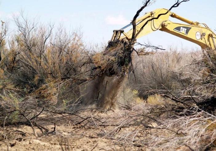
12 Tamarisk removal Treatment 63 acres 12


13 Tamarisk Removal Objectives Encourage lateral channel migration Increase wood inputs to river Pre-Flood Promote native vegetation establishment Limited access to floodplain Poor timing Post-Flood
14 Beaver

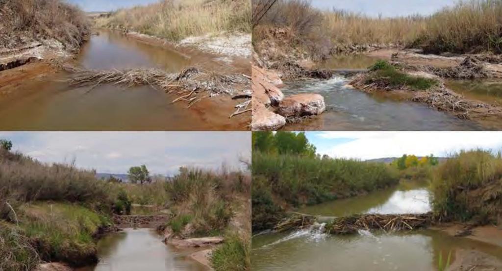
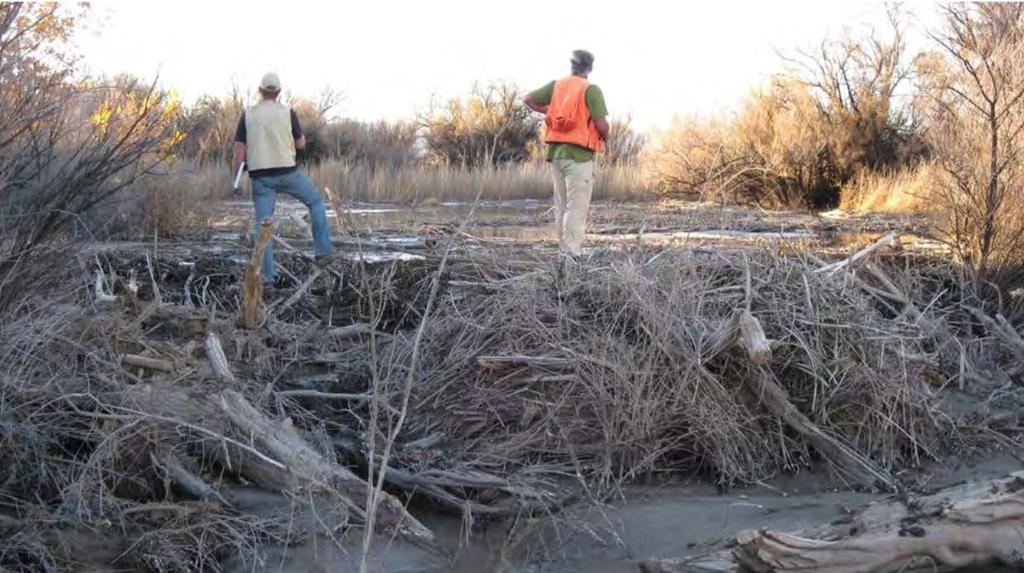
15 Beaver Dam Analogs 8 complexes; 34 structures 15


16 Beaver Dam Analogs Outcomes 31 of 34 structures breached most structures provided local increases in topographic complexity Bank scour 16


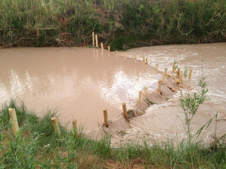
17 Mixed sand and gravel bar deposit Beaver Dam Analogs BDA 15 m 17


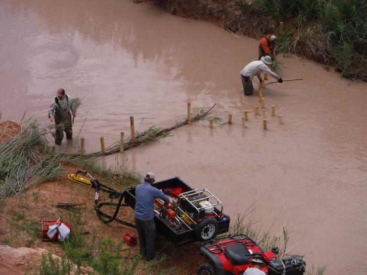
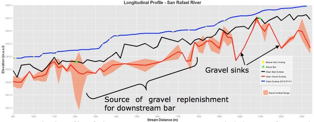
18 2 bars ~60 tons each Artificial Gravel Bars 18


19 kg/m 2 Artificial Gravel Bars Increased amount of exposed gravels in the bed downstream of the bar Tracer study provided insight on the sources and sinks of native gravel Exposed gravel Gravel bar 19
20 20

21 Lessons learned 1. Baby steps 2. Monitor 3. Adapt 21


22 Acknowledgements Funding Bureau of Reclamation Bureau of Land Management National Fish and Wildlife Foundation Utah Division of Wildlife Resources US Geological Survey Utah Cooperative Fish and Wildlife Research Unit Utah Watershed Restoration Initiative People Researchers Jared Bottcher, Tim Walsworth, Steve Fortney San Rafael Team Paul Birdsey, Jeff Brower, Dave Dean, Dan Eddington, Ian Gowing, Carl Ivory, Jeremy Jarnecke, Dan Keller, Wally Macfarlane, Peter MacKinnon, Milada Majerova, Chris McGinty, Cassie Mellon, Justin Miner, Elijah Portugal, Jared Reese, Jack Schmidt, Mike Scott, Dave Speas, Gary Thiede, Dana Truman, Peter Wilcock, Krissy Wilson, et al. Plan Reviewers Paul Badame, Melissa Dickard, Julie Knudson, Thomas Mendenhall, Christine Rasmussen, Michael Roberts, Janice Staats People Beaver Analogs Ben Stout, Kelsey Ballard, Alex Walker, Others: Angela, David, Jayla, Jordan, Michaela, Mike, Nicole, Sean, TJ

23 Questions 23
24 Articles, Reports and Theses Bottcher, J. L. (2009). Maintaining Population Persistence in the Face of an Extremely Altered Hydrograph : Implications for Three Sensitive Fishes in a Tributary of the Green River, Utah. 73. Bottcher, J. L., Walsworth, T. E., Thiede, G. P., Budy, P., and Speas, D. W. (2013). Frequent Usage of Tributaries by the Endangered Fishes of the Upper Colorado River Basin: Observations from the San Rafael River, Utah. North American Journal of Fisheries Management, 33(3), Budy, P., Bottcher, J., and Thiede, G. P. (2009). Habitat needs, movement patterns, and vital rates of endemic Utah fishes in a tributary to the Green River, Utah. Fortney, S. (2013a). Thesis Chapter 3: Channel Change on the lower San Rafael River, UT. Utah State University. Fortney, S. (2013b). Thesis Chapter 2 : Geomorphic Organization of the lower 90 kilometers of the San Rafael River. Utah State University. Fortney, S. T., Schmidt, J. C., and Dean, D. J. (2011). Final Report Establishing the geomorphic context for wetland and riverine restoration of the San Rafael River. Logan, UT. Laub, B. (2013). Restoration and Monitoring Plan for Native Fish and Riparian Vegetation on the San Rafael River, Utah. Logan. Laub, B. G., and Budy, P. (2015). Assessing the likely effectiveness of multispecies management for imperiled desert fishes with niche overlap analysis. Conservation Biology, 00(11). Macfarlane, W. W., and McGinty, C. M. (2012). Fine Scale Riparian Vegetation Mapping Lower San Rafael River Report to the Bureau of Land Management. BLM. (2014). Ch.1-2, Environmental Assessment, Lower San Rafael River Restoration Project, DOI-BLM-UT-G EA. Price, UT. Walsworth, T. (2011). Analysis of food web effects of non-native fishes and evaluation of stream restoration potential for the San Rafael River, Utah Walsworth, T. E., Budy, P., and Thiede, G. P. (2013). Longer food chains and crowded niche space: effects of multiple invaders on desert stream food web structure. Ecology of Freshwater Fish, 22(3),
Phoenix Habitat Restoration Projects
 Phoenix Habitat Restoration Projects Spur Cross Ranch Cave Creek (Estergard) Regional Tree and Shade Summit March 9, 2010 Desert Riparian Ecosystems Healthy riparian areas like this once existed along
The Lower Prut Floodplain Natural Park (Romania)
") The Lower Prut Floodplain Natural Park (Romania) Gabriela Costea Natural Sciences Museum Complex Galati (Romania) & member of the Scientific Council of the Lower Prut Floodplain Natural Park The Prut The
The Lower Prut Floodplain Natural Park (Romania) Gabriela Costea Natural Sciences Museum Complex Galati (Romania) & member of the Scientific Council of the Lower Prut Floodplain Natural Park The Prut The
SAN ANTONIO RIVER IMPROVEMENTS PROJECT. August 6, 2008
 SAN ANTONIO RIVER IMPROVEMENTS PROJECT August 6, 2008 1 History of the SA River Improvements 1921 Flood Olmos Dam Complete in 1929 Downtown Flood Relief Projects in 1950 s Dams on the River Channel and
STREAKED HORNED LARK. Conservation of a threatened species in an industrial landscape. Cat Brown US Fish and Wildlife Service
 STREAKED HORNED LARK Conservation of a threatened species in an industrial landscape Cat Brown US Fish and Wildlife Service HISTORICAL & CURRENT RANGE Streaked Horned Lark Distribution Historical Range:
Damn those dams their effects on stream ecosystems
 Damn those dams their effects on stream ecosystems Jeremy Tiemann Illinois Natural History Survey Prairie Research Institute at the University of Illinois History of dams History of dams First evidence
SAN ANTONIO RIVER IMPROVEMENTS PROJECT. April 27, 2009
 SAN ANTONIO RIVER IMPROVEMENTS PROJECT April 27, 2009 1 Project Limits 2 Project Partners City of San Antonio Provides project funding for project amenities (i.e.. Sidewalks, Landscaping, Lighting, etc.)
Michipicoten Island Regional Plan
 Michipicoten Island Regional Plan This is one of twenty Regional Plans that support implementation of the Lake Superior Biodiversity Conservation Strategy (Strategy). The Strategy, prepared and overseen
DIDYMO SURVEY, LOWER FRYINGPAN RIVER, BASALT, COLORADO 2015
 DIDYMO SURVEY, LOWER FRYINGPAN RIVER, BASALT, COLORADO 2015 Second Annual Report PREPARED FOR: ROARING FORK CONSERVANCY PREPARED BY: COLORADO MOUNTAIN COLLEGE NATURAL RESOURCE MANAGEMENT PROGRAM TIMBERLINE
SUPPORT TO WATER RESOURCES MANAGEMENT IN THE DRINA RIVER BASIN DRAFT ROOF REPORT INTRODUCTION AND GENERAL APPROACH
 SUPPORT TO WATER RESOURCES MANAGEMENT IN THE DRINA RIVER BASIN DRAFT ROOF REPORT INTRODUCTION AND GENERAL APPROACH Nadja Zeleznik, REC Public Concultation Beograd, Serbia, 4 July 2017 1 1. Introduction
Juvenile coho salmon use of constructed off-channel habitats in two Lower Klamath River tributaries: McGarvey Creek & Terwer Creek
 Juvenile coho salmon use of constructed off-channel habitats in two Lower Klamath River tributaries: McGarvey Creek & Terwer Creek Prepared by: Yurok Tribal Fisheries Program PO Box 1027, Klamath, CA Spring
Decision Memo for Desolation Trail: Mill D to Desolation Lake Trail Relocation
 for Salt Lake County, Utah Uinta-Wasatch-Cache National Forest Salt Lake Ranger District 1. Background The present location of the Desolation Trail (#1159) between Mill D and Desolation Lake follows old
Finn Creek Park. Management Direction Statement Amendment
 Finn Creek Park Management Direction Statement Amendment November 2013 Management Direction Statement Amendment Approved by: Jeff Leahy Regional Director, Thompson Cariboo BC Parks November 12, 2013 Date
APPENDIX 'A' Summary of Sage Grouse Petitions Submitted to the U.S. Fish and Wildlife Service (USFWS) 1 (As of January 8, 2004)
 1 (As of January 8, 2004)") APPENDIX 'A' Summary of Sage Grouse Petitions Submitted to the U.S. Fish and Wildlife Service (USFWS) 1 (As of January 8, 2004) Petition Date: May 14, 1999 (74 pages) Species: Washington population of
APPENDIX 'A' Summary of Sage Grouse Petitions Submitted to the U.S. Fish and Wildlife Service (USFWS) 1 (As of January 8, 2004) Petition Date: May 14, 1999 (74 pages) Species: Washington population of
Colorado s Instream Flow Program at 40. ICWP Annual Conference October 16, 2013 Denver, Colorado
 Colorado s Instream Flow Program at 40 ICWP Annual Conference October 16, 2013 Denver, Colorado ISF Program established in 1973 by Senate Bill 97 Recognized the need to correlate the activities of mankind
SECTION 3 GENERAL DESCRIPTION OF THE RIVER BASIN
 SECTION 3 GENERAL DESCRIPTION OF THE RIVER BASIN SECTION 3 GENERAL DESCRIPTION OF THE RIVER BASIN River basin description. A general description of the river basin or subbasin, as appropriate, in which
The Vjosa River in Albania
 The Vjosa River in Albania Europe s Wild jewel - beautiful, unknown and threatened The extensive braided river section near Tepelena would drown in a reservoir of the future Kalivaç dam. (Romy Durst) Major
Cat Island Chain Background & Access Guide
 Cat Chain Background & Access Guide Brown County Port & Resource Recovery Department 2561 S. Broadway, Green Bay, WI 54304 (920) 492-4950 www.portofgreenbay.com January 2018 1 Restoration of the Cat Chain
Mackinnon Esker Ecological Reserve Draft - Management Plan
 Mackinnon Esker Ecological Reserve Draft - Management Plan May 2011 Photo Credit: This document replaces the direction provided in the Carp Lake Provincial Park and Protected Area and Mackinnon Esker Ecological
Daisy Dean Trail 628/619 ATV Trail Construction
 Background and Purpose and Need The Daisy Dean ATV Trail Construction Project is located in the Little Belt Mountains, Musselshell Ranger District, Lewis and Clark National Forest approximately 32 miles
Europe s wild jewel - The Vjosa River in Albania
 SAVE THE BLUE HEART OF EUROPE THE BALKAN RIVERS Europe s wild jewel - The Vjosa River in Albania BEAUTIFUL, UNKNOWN AND THREATENED The extensive braided river section near Tepelena would drown in a reservoir
PRESPA BIOSPHERE RESERVE MANAGEMENT MACEDONIAN PERSPECTIVE
 PRESPA BIOSPHERE RESERVE MANAGEMENT MACEDONIAN PERSPECTIVE Secretariat by Ohrid, 10.03.2016 Prespa Ohid TBB reserve Biodiversity richness trans-boundary level Total Species richness Registered over 1500
Water in the Amazon. By Heather and Georgie
 Water in the Amazon By Heather and Georgie The Amazon is the world s largest tropical rainforest. The Amazon is so big that the U.K and Ireland would fit into it 17 times. The Amazon River It s length
Case Study: Conserving Ecological Processes in the Eastern Himalayas
 Standard 7: Select terrestrial, freshwater and marine conservation biodiversity elements (a.k.a conservation targets) across multiple biological scales to comprehensively represent the biodiversity of
The Design of Nature Reserves
 The Design of Nature Reserves Goals Maintenance of MVP s for targeted species Maintenance of intact communities Minimization of disease Considerations of reserve design 1. Disturbance regime Fire Insect
Nature Conservation Agency (NCA) Salacgrīva 05/07/2018
 Salacgrīva 05/07/2018") Nature Conservation Agency (NCA) Salacgrīva 05/07/2018 Nature Conservation Agency ensures implementation of unified nature protection policy in Latvia Specially protected nature areas in Latvia Specially
Nature Conservation Agency (NCA) Salacgrīva 05/07/2018 Nature Conservation Agency ensures implementation of unified nature protection policy in Latvia Specially protected nature areas in Latvia Specially
Aquatic insect surveys at Mount Magazine State Park and Hobbs State Park Conservation Area with implementation of an educational component
 Aquatic insect surveys at Mount Magazine State Park and Hobbs State Park Conservation Area with implementation of an educational component Arkansas is home to a relatively large number of endemic invertebrates
KASKASKIA RIVER NAVIGATION POOL Compartment 12 UNIT 1 Kaskaskia Lock and Dam Lands These lands are now being managed by the Carlyle Lake project
 KASKASKIA RIVER NAVIGATION POOL Compartment 12 UNIT 1 Kaskaskia Lock and Dam Lands These lands are now being managed by the Carlyle Lake project office. Sections 1-4 in this plan present Kaskaskia River
The Partnership Wild & Scenic Rivers Program
 BUDGET REQUEST FISCAL YEAR 2017 Proven, cost-effective protection for 770 miles of rivers and thousands of acres of riparian land Westfield River, MA (L) and Farmington River, CT (R) Partnership Wild &
Hydro-Electric Schemes Compliance Report June June 2013
 File Reference: 4.00212 Significance of Decision: Receives Only - No Decisions Report To: Operations, Monitoring and Regulation Committee Meeting Date: 20 June 2013 Report From: Nick Zaman, Pollution Prevention
Colorado s Instream Flow Program at 40. Celebrating 40 Years of Success and Challenges January 15, 2014 Denver, Colorado
 Colorado s Instream Flow Program at 40 Celebrating 40 Years of Success and Challenges January 15, 2014 Denver, Colorado ISF Program established in 1973 by Senate Bill 97 Recognized the need to correlate
A pilot flood retention area in La Bassée
 A pilot flood retention area in La Bassée Institution interdépartementale des barrages-réservoirs du bassin de la Seine 8, rue Villiot - 75012 Paris - Tél. : 01 44 75 29 29 - Télécopie : 01 44 75 29 30
Dr. Christopher Brown New Mexico State University GEF Project Rio Meeting Ciudad Juárez, México 3-5 October 2006
 Political and Institutional Aspects of Rio Grande/ Río Bravo Basin Management Dr. Christopher Brown New Mexico State University GEF Project Rio Meeting Ciudad Juárez, México 3-5 October 2006 Institutional
Park Updates 1. Cavalero 2. Lundeen 3. Frontier Heights Citizen Advisory Committee
 Page 1 of 10 PARK BOARD AGENDA Community Center 1808 Main Street, Lake Stevens Monday, April 11, 2016 CALL TO ORDER: 6:00 pm ROLL CALL: GUEST BUSINESS: ACTION ITEMS: A. B. C. Approval of February 8, 2016
THE SAN JUAN RIVER BASIN PROJECT
 Formulation of a Strategic Actions Program for the Integrated Management of the Hydrological Resources and Sustainable Development of the San Juan River Basin and its Coastal zone PROCUENCA SAN JUAN THE
Case Study: 1. The Clarence River Catchment
 Case Study: 1. The Clarence River Catchment The NSW coastline is a great natural asset, making an enormous contribution to the economy. The resources of coastal catchments such as the Clarence River Catchment,
National Park Service - Coho Salmon & Steelhead Trout Restoration Project
 National Park Service Point Reyes National Seashore Salmonid Trends in Lagunitas and Redwood Creek Mt. Tamalpais Watersheds National Park Service - Coho Salmon & Steelhead Trout Restoration Project Brannon
Ohrid Lake and Prespa Lake, Sub basin s on Crn Drim river basin International Workshop, Sarajevo, Bosna and Hercegovina May 2009
 Ohrid Lake and Prespa Lake, Sub basin s on Crn Drim river basin International Workshop, Sarajevo, Bosna and Hercegovina 18-20 May 2009 Ms. Darinka Jantinska Ministry of Environment and Physical Planning
Bradley Brook Relocation Project. Scoping Notice. Saco Ranger District. United States Department of Agriculture Forest Service
 Bradley Brook Relocation Project United States Department of Agriculture Forest Service Scoping Notice White Mountain National Forest February 2011 For Information Contact: Jenny Burnett White Mountain
ROAD AND TRAIL PROJECT APPROVAL
 ROAD AND TRAIL PROJECT APPROVAL www.marincountyparks.org Marin County Parks, 3501 Civic Center Dr, Suite 260, San Rafael, CA 94903 DATE: July 12, 2017 PRESERVE: Gary Giacomini Open Space Preserve PROJECT:
Conservation Partners for the National Reserve System Program: a Western NSW focus
 Conservation Partners for the National Reserve System Program: a Western NSW focus Cooper, N. 1, Webber, L. 2, Nicolson, K. 3 1 Department of Environment, Climate Change and Water NSW, PO Box 788 Broken
Biosphere Reserves of India : Complete Study Notes
 Biosphere Reserves of India : Complete Study Notes Author : Oliveboard Date : April 7, 2017 Biosphere reserves of India form an important topic for the UPSC CSE preparation. This blog post covers all important
X. WHATCOM CREEK SMA. X.1 Watershed Analysis. X.1.1 Landscape Setting
 X. WHATCOM CREEK SMA Summary: The entire length of Whatcom Creek is located within the City of Bellingham. SMA jurisdiction associated with this creek is approximately 300 acres. Land use is dominated
DATE: January 19, WCA Governing Board. Johnathan Perisho, Project Manager. Mark Stanley, Executive Officer
 Item 14 DATE: January 19, 2017 TO: FROM: THROUGH: SUBJECT: WCA Governing Board Johnathan Perisho, Project Manager Mark Stanley, Executive Officer Item 14: Consideration of a resolution to accept an acquisition
Map 1.1 Wenatchee Watershed Land Ownership
 Map 1.1 Wenatchee Watershed Land Ownership Map 1.1 Wenatchee Watershed Land Ownership The Wenatchee watershed lies in the heart of Washington state in Chelan County. Just larger than the state of Rhode
TOWARDS SUSTAINABLE MANAGEMENT OF MARINE AND COASTAL HABITATS ASIA- PACIFIC DAY FOR THE OCEAN
 TOWARDS SUSTAINABLE MANAGEMENT OF MARINE AND COASTAL HABITATS WANNAKIAT THUBTHIMSANG PHUKET MARINE BIOLOGICAL CENTER, DMCR, THAILAND ASIA- PACIFIC DAY FOR THE OCEAN 20 NOVEMBER 2018, CONFERENCE ROOM 4,
AMENDMENT NO. 03 TO THE OFFICIAL PLAN FOR THE TOWNSHIP OF ADJALA-TOSORONTIO OAK RIDGES MORAINE CONSERVATION PLAN
 AMENDMENT NO. 03 TO THE OFFICIAL PLAN FOR THE TOWNSHIP OF ADJALA-TOSORONTIO OAK RIDGES MORAINE CONSERVATION PLAN Adopted by Council July 19 th, 2004 Approved with modifications by the Province of Ontario
Pinellas County Environmental Lands
 Pinellas County Environmental Lands In addition to traditional parks and recreation facilities, Pinellas County owns and manages a system of environmental lands that provides specialized resource-based
How South Africa is making progress towards the Aichi 2020 Target 11
 How South Africa is making progress towards the Aichi 2020 Target 11 Montreal, Canada 2 May 2016 Oceans and Coasts Content Protected area considerations and progress 1994-2010 Terrestrial Protected Area
Enhancement of Salmonid Rearing Habitat in McGarvey Creek - Lower Klamath River
 Enhancement of Salmonid Rearing Habitat in McGarvey Creek - Lower Klamath River Prepared by: Sarah Beesley Yurok Tribal Fisheries Program PO Box 1027 Klamath, California 95548 and Rocco Fiori, Fiori GeoSciences
Field excursion 4: ERRC2014 SEE River Final Project Event
 Field excursion 4: ERRC2014 SEE River Final Project Event Fish migration and river restoration at Danube tributaries The field trip will focus on fish passes and river restoration projects in the province
Introduction on the Taedong River Basin.
 Introduction on the Taedong River Basin. The 17th Regional Steering Committee Meeting for Southeast Asia and the Pacific - UNESCO IHP November 2-6 2009 Wuhan China National Committee of DPR Korea for IHP
Appendix I. Wilderness Review
 Appendix I. Wilderness Review This appendix contains the wilderness inventory conducted for the Ash Meadows, Moapa Valley, and Pahranagat National Wildlife Refuges (NWRs) as part of the Comprehensive Conservation
Paul Sturm Roberto Viqueira Ríos
 Paul Sturm Roberto Viqueira Ríos In this talk Brief Background on Land Based Sources Historical Perspective Guánica watershed characteristics/ issues High priority restoration projects Other key issues
INTRODUCTION 250,000
 INTRODUCTION The United States of America has over 250,000 rivers, with a total of about 3,500,000 miles of rivers. The main stems of 38 rivers in the United States are at least 500 miles (800 km) long.
TRINITY RIVER CORRIDOR
 TRINITY RIVER CORRIDOR MODIFIED DALLAS FLOODWAY PROJECT UPDATE May 12, 2015 Jon Loxley Project Manager Dallas Floodway Project Fort Worth District U.S. Army Corps of Engineers US Army Corps of Engineers
Mark West Creek Flow Study Report
 Mark West Creek Flow Study Report Biology and Geology of Mark West Creek The headwaters of Mark West Creek are located in the Mayacamas Mountain range, which border Napa and Sonoma County, where it then
26 Utah s Patchwork Parkway SCENIC BYWAY CORRIDOR MANAGEMENT PLAN (SR 143)
") Natural Natural Quality applies to those features in the visual environment that are in a relatively undisturbed state. These features predate the arrival of human populations and may include geological
Natural Natural Quality applies to those features in the visual environment that are in a relatively undisturbed state. These features predate the arrival of human populations and may include geological
MINUTES. Additional Stakeholders including CU, CDOT, Town of Erie, and Weld County have been contacted and invited to the recurring progress meetings.
 PROGRESS MEETING BOULDER CREEK MASTER PLAN UDFCD, BOULDER COUNTY, CITIES OF BOULDER & LONGMONT JANUARY 13, 2015 AT 1:00 PM MINUTES 1) ATTENDEES Craig Jacobson, ICON Engineering, Inc. Brian LeDoux, ICON
Attachment O Verified Statement of Christopher Banet Page 1 of 7
 Attachment O Verified Statement of Christopher Banet Page 1 of 7 Attachment O Verified Statement of Christopher Banet Page 2 of 7 Curriculum Vitae Education Christopher Banet United States Department of
A Vision for South Skunk River and Chichaqua Bottoms Greenbelt
 A Vision for South Skunk River and Chichaqua Bottoms Greenbelt Photo: Jim Pease Chichaqua Bottoms Booklet 7 of 8 Greater Des Moines Water Trails and Greenways 1 2016 Table of Contents Booklet 1: Water
Greening Project Status Report: Grand Canyon National Park
 Greening Project Status Report: Grand Canyon National Park Prepared for the Federal Energy Management Program U.S. Department of Energy February 2001 iii Contents Page 1. Introduction... 1 2. Context of
Chuckanut Ridge Fairhaven Highlands EIS Scoping Concerns
 Chuckanut Ridge Fairhaven Highlands EIS Scoping Concerns Coalition of Southside Neighborhoods CSN Comments for Fairhaven Highlands EIS Scope Hearing, Jan 16, 2008 1 Chuckanut Ridge Hilly Terrain: Potential
White Mountain National Forest Saco Ranger District
 United States Department of Agriculture Forest Service White Mountain National Forest 33 Kancamagus Highway Conway, NH 03818 Comm: (603) 447-5448 TTY: (603) 447-3121 File Code: 1950 Date: February 26,
Comanche National Grassland, Timpas Unit
 Comanche National Grassland, Timpas Unit Heritage Resources More than 540 sites are eligible for listing on the National Register of Historic Places (NRHP) by Forest Service staff and/or the Colorado State
Gatwick Stream Riverside Garden Park, Horley
 Gatwick Stream Riverside Garden Park, Horley An Advisory Visit by the Wild Trout Trust January 2014 1 1. Introduction This report is the output of a Wild Trout Trust visit to the Gatwick Stream in Horley,
BUCK POINT RANCH. Aspen Associates Realty
 BUCK POINT RANCH Aspen Associates Realty www.aspenassociatesrealty.com 970.544.5800 WELCOME TO Buck Point Ranch is a 960± acre property located in one of the last pristine valleys in close proximity to
Carson City Open Space APNs and , west of Deer Run Road bridge
 32 acres (See separate packet for information on this open space property) OPEN SPACE PROPERTY APNs 008-541-73 and 008-541-92 (north and south sides of the river) Morgan Mill Road River Access Area (parking
The Sonoran Desert Conservation Plan. Our Land, Our Home, Our Way of Life
 The Sonoran Desert Conservation Plan Our Land, Our Home, Our Way of Life Coalition for Sonoran Desert Protection The Sonoran Desert Conservation Plan The Sonoran Desert Conservation Plan is a comprehensive
ROUGE RIVER REPORT CARD
 ROUGE RIVER REPORT CARD Noel Mullett, Wayne County Rouge River Report Card The Rouge River communities, residents and partners continue to address watershed issues Water quality and ecosystem health continues
The Danube Experience
 The Danube Experience Dealing with Hydromorphological Issues the Danube Experience Philip Weller Executive Secretary, ICPDR Danube River Basin- Overview The Danube River Basin is the most international
Resource Management Tract Management Plan. May, 2015 PHOTO NEEDED. Cover photo credit: Barry Westhead
 PHOTO NEEDED Resource Management Tract Management Plan May, 2015 A Cover photo credit: Barry Westhead 1.0 INTRODUCTION TABLE OF CONTENTS AUTHORITY RESOLUTION At Authority Meeting #6/14, held on July 25,
Flow Stand Up Paddle Board Parkway Plan Analysis
 Regional Parks Department Jeffrey R. Leatherman, Director County of Sacramento Divisions Administration Golf Leisure Services Maintenance Rangers Therapeutic Recreation Services Flow Stand Up Paddle Board
Bridge River Delta Park. Management Plan. Final Public Review Draft
 Bridge River Delta Park Management Plan Final Public Review Draft March 2016 Bridge River Delta Park Management Plan Approved by: Jeff Leahy Regional Director Thompson Cariboo Region BC Parks Date Brian
Land Use. Grasslands and Rangelands National Parks and Reserves. Thursday, October 9, 14
 Land Use Grasslands and Rangelands National Parks and Reserves MANAGING AND SUSTAINING GRASSLANDS Almost half of the world s livestock graze on natural grasslands (rangelands) and managed grasslands (pastures).
Coastal Dune Locations of Ontario
 Coastal Dune Protection along Ontario s Great Lakes Coast Great Lakes Dune Conference, Traverse City, Michigan Oct 3 4, 2006 J. Childs, WLU Dunes in Ontario Coastal very small % of coastline Located: At
Version Isolated & Non-Waters Only 1 of 3
 APPROVED JURISDICTIONAL DETERMINATION FORM U.S. Army Corps of Engineers SECTION I: BACKGROUND INFORMATION A. REPORT COMPLETION DATE FOR APPROVED JURISDICTIONAL DETERMINATION (JD): July 6, 2010. B. DISTRICT
Conservation of Critical Environmental Resources in Chatham Park
 Conservation of Critical Environmental Resources in Chatham Park Elaine Chiosso, Haw Riverkeeper Haw River Assembly Haw River As Seen From Chatham Park "Spreading southwestward from the banks of the Haw
Piedra River Protection Workgroup Meeting #5 Feb. 21, 2012 Ross Aragon Community Center, Pagosa Springs
 Piedra River Protection Workgroup Meeting #5 Feb. 21, 2012 Ross Aragon Community Center, Pagosa Springs What happened at this meeting? - Identified conservation easements - Discussed In-stream Flows -
Dr. Lkhagvasuren Badamjav Leading Scientist, Institute of Biology Mongolian Academy of Sciences
 Transboundary landscape cooperation in the Altay-Sayan region: experiences and lessons learnt Dr. Lkhagvasuren Badamjav Leading Scientist, Institute of Biology Mongolian Academy of Sciences Stakeholder
ECORREGIONAL ASSESSMENT: EASTERN CORDILLERA REAL ORIENTAL PARAMOS AND MONTANE FORESTS
 ECORREGIONAL ASSESSMENT: EASTERN CORDILLERA REAL ORIENTAL PARAMOS AND MONTANE FORESTS The Nature Conservancy, EcoCiencia y Fundación AGUA. 2005. Evaluación Ecorregional de los Páramos y Bosques Montanos
BEFORE PROJECT THE BEGINNING
 BEFORE PROJECT THE BEGINNING SWBNP is a final sample of the former Lakes of Danube. On an area of 241 km2, PN-BmB retain 10% of the former Inland River Delta, the former Lake of Brăila and Ialomiţei, who
Image donated by Hilltown local artist MICHAEL WOLSKI (www.michaelwolski.com)
") Executive Summary Middle Branch Image donated by Hilltown local artist MICHAEL WOLSKI (www.michaelwolski.com) Middle Branch Highlights: Over 65 volunteers surveyed approximately 70 miles of the Westfield
Executive Summary Middle Branch Image donated by Hilltown local artist MICHAEL WOLSKI (www.michaelwolski.com) Middle Branch Highlights: Over 65 volunteers surveyed approximately 70 miles of the Westfield
One Source, Multiple Challenges: The Future Evolution of Water Policy and the Case of the Colorado River
 One Source, Multiple Challenges: The Future Evolution of Water Policy and the Case of the Colorado River David H. Getches Dean and Raphael J. Moses Professor of Natural Resources Law University of Colorado
North Shore Lacamas Lake
 North Shore Lacamas Lake January 27, 2017 A Vision for Conservation and Recreation Acknowledgements Funding Funding for this planning effort was provided by the City of Camas and the Columbia Land rust
Environmental Impact Assessment of the dredging operations and aids to navigation works in the Argentina s Santa Fe Confluencia waterway.
 of the dredging operations and aids to navigation works in the Argentina s Santa Fe Confluencia waterway. LIC. CLAUDIO DANIELE cdaniele@estudioayd.com.ar Presented by Ing. Martín Civeira Study area Argentina
Caring for our Lake our Future
 Caring for our Lake our Future The Management Plan for Lake Shkodra Nature Park A Summary Photo Tonin Macaj This brochure is partly funded by the European Union Lake Shkodra: plentiful nature, long human
Decision Memo Broken Wheel Ranch Equestrian Outfitter Special-Use Permit Proposed Action
 Decision Memo Broken Wheel Ranch Equestrian Outfitter Special-Use Permit USDA Forest Service Mississippi Bluffs Ranger District, Shawnee National Forest Jackson and Union Counties, Illinois Proposed Action
Plaza del Rio. Rio Grande Sanctuary. Exclusive Home Sites in the San Luis Valley, Colorado
 Plaza del Rio Rio Grande Sanctuary Photography by Gary Tyson River Valley Group, LLC and Team Murphy Realty, LLC offer for sale: Exclusive Home Sites in the San Luis Valley, Colorado Plaza del Rio Exclusive
BOULDER CREEK CATTLE FENCING FOR KOKANEE HABITAT ENHANCEMENT 2010
 BOULDER CREEK CATTLE FENCING FOR KOKANEE HABITAT ENHANCEMENT 2010 Prepared for the: FISH & WILDLIFE COMPENSATION PROGRAM, NELSON, B.C. Prepared by: Marc André Beaucher CRESTON VALLEY WILDLIFE MANAGEMENT
APPENDIX G. The WAP Conservation Landscape and Focal Areas
 APPENDIX G The WAP Conservation Landscape and Focal Areas Focal areas were identified as discrete landscape units using the natural basin and range geography of the Nevada landscape. These units were prioritized
Lewis and Clark National Historic Trail
 National Trails System Land and Water Conservation Fund FY2014 Lewis and Clark National Historic Trail Total LWCF Request: $ 3,130,000 Project Name Agency District # Tracts Acres Total Cost Columbia River
ECOREGIONAL ASSESSMENT EQUATORIAL PACIFIC EXECUTIVE SUMMARY
 ECOREGIONAL ASSESSMENT EQUATORIAL PACIFIC The Nature Conservancy, Fundación Agua, EcoCiencia, Fundación Jatun Sacha, CDC Ecuador, CDC UNALM 2004. Portafolio de Sitios Prioritarios para la Conservación
Alternative 3 Prohibit Road Construction, Reconstruction, and Timber Harvest Except for Stewardship Purposes B Within Inventoried Roadless Areas
 Roadless Area Conservation FEIS Summary Table S-1. Comparison of Key Characteristics and Effects by Prohibition Alternative. The effects summarized in this table A would occur in inventoried roadless areas
International Osoyoos Lake Board of Control Annual Report to the International Joint Commission
 International Osoyoos Lake Board of Control 2015 Annual Report to the International Joint Commission Cover: Northern extent of Osoyoos Lake, where the Okanagan River enters the lake, 2015. View is to the
Course Outline. Part I
 Course Outline Part I Programme Title : All Full-time Undergraduate Programmes Course Title : Conservation and Ecotourism Course code : COC1040 / CSL1013 Department : Science and Environmental Studies
Youth Corps Project Report BUREAU OF LAND MANAGEMENT COLORADO STATE OFFICE
 Youth Corps Project Report BUREAU OF LAND MANAGEMENT COLORADO STATE OFFICE FISCAL YEAR 2013 Colorado Youth Corps Association www.cyca.org 1 Table of Contents Program Summary 3 Individual Project Summaries
April 10, Mark Stiles San Juan Public Lands Center Manager 15 Burnett Court Durango, CO Dear Mark,
 Mark Stiles San Juan Public Lands Center Manager 15 Burnett Court Durango, CO 81301 Dear Mark, We are pleased to offer the following comments on the draft San Juan Public Lands Center management plans
International Sava River Basin Commission
 International Sava River Basin Commission Pilot project on climate change: Building the link between the Flood Risk Management planning and climate change assessment in the Sava River Basin climate change
LPBF/UNO APPENDIX A Overlays Maps &
 APPENDIX A Maps & Overlays HOW TO USE THE FOLLOWING MAPS AND S: Several lessons instruct you to use the maps in this Appendix. 1. 2. 3. 4. First, make a transparency of each map required for the activity.
Twelve Apostles Marine National Park Australia
 EVALUATION REPORT Twelve Apostles Marine National Park Australia Location: Victoria, Australia coastal waters Global Ocean Refuge Status: Nominated (2017), Evaluated (2017) MPAtlas.org ID: 7703885 Manager(s):