Lewis and Clark National Historic Trail
|
|
|
- Ethan Bennett
- 5 years ago
- Views:
Transcription
1 National Trails System Land and Water Conservation Fund FY2014 Lewis and Clark National Historic Trail Total LWCF Request: $ 3,130,000 Project Name Agency District # Tracts Acres Total Cost Columbia River Gorge FWS WA $1,500,000 and Lake River Unit, Ridgefield NWR Complex Lolo Creek (in conjunction BLM ID $30,000 with Nez Perce NHT) Cow Island and Cow Creek BLM MT $1,600,000 (in conjunction with Nez Perce NHT) Totals: $3,130,000 Prepared in collaboration by: The Lewis and Clark Trail Heritage Foundation (406) The Lewis and Clark Trust, Inc. (859) The Partnership for the National Trails System (608)

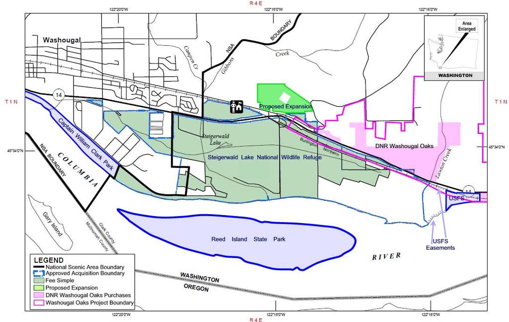
2 National Trails System Land and Water Conservation Fund FY2014 Lewis and Clark National Historic Trail Columbia River Gorge and Lake River Unit Ridgefield National Wildlife Refuge Complex, Washington Project Details LWCF Request: $1,500,000 Congressional District: WA-3, Representative Herrera Beutler Acres: 123 Miles of Trail: 4 Tracts: 6 Acquiring Agency: FWS Columbia River from Bridge of the Gods. Credit: Richard Prestholdt, Prestholdt Images, Founding Member of the Lewis and Clark Trust, Inc. Landscape Characteristics: These tracts contain a mixture of riparian bottomland forest, wet meadows during seasonal flood events, and pastures between Lake River and Campbell Lake. The riparian forests are comprised of Pacific willow in the lower elevation flats transitioning to black cottonwood, and are home to resident and migrant neotropical songbirds. Scattered individual Oregon white oaks occupy the highest terraces above the influence of frequent flood events, and have value in attracting and sustaining oak obligate wildlife species like slender-billed white-breasted nuthatches. Dusky Canada geese and other waterfowl are known to concentrate in the pastures and wet meadows of this parcel. Benefits of Protection: Protection of an intact historic scene representing what the Corps of Discovery saw and experienced including 45 acres and four linear miles of riparian area along the Lake River, and improved protection of a threatened habitat type within the boundaries of the Ridgefield NWR Complex. Threats to the Landscape: Destruction of natural and heritage resources, agricultural conversion, loss of public access, visual intrusion, residential development, and loss of habitat for threatened and endangered species. Prepared in collaboration by: The Lewis and Clark Trail Heritage Foundation (406) The Lewis and Clark Trust, Inc. (859) The Partnership for the National Trails System (608)
3

4 National Trails System Land and Water Conservation Fund FY2014 Nez Perce National Historic Trail & Lewis and Clark National Historic Trail Lolo Creek Idaho Project Details LWCF Request: $30,000 Congressional District: ID-1, Representative Labrador Acres: 12 Miles of Trail: 2.5 Acquiring Agency: BLM Landscape Characteristics: This tract will preserve a key section of the Nez Perce and Lewis and Clark Nez Perce NHT near Kamiah, Idaho along Lolo Creek. BLM photo. National Historic Trails. The Nez Perce people used the trail to access the buffalo plains in Montana and the Weippe Prairie and to travel between the camas grounds near Weippe and the Clearwater River. The Nez Perce also used the trail during the Nez Perce War in 1877 as a route over the Bitterroot Mountains into Montana. In addition, the Lewis and Clark Expedition used the trail during their return to the Eastern United States in 1806 while guided by Nez Perce. The BLM manages Lolo Creek as an Area of Critical Environmental Concern and Special Recreational Management Area under an approved Cottonwood Resource Management Plan (2009). Lolo Creek is considered suitable as a proposed National Wild and Scenic River. Benefits of Protection: Preservation of the Nez Perce and Lewis and Clark National Historic Trails and protection of land within the BLM s ACEC and SRMA while preserving the outstanding remarkable values of Lolo Creek as outlined through Congress proposal to designate the creek as a National Wild and Scenic River. Threats to the Landscape: Destruction of natural and heritage resource, loss of public access, visual intrusion, and residential development. Prepared in collaboration by: The Nez Perce Trail Foundation (208) The Lewis and Clark Trail Heritage Foundation (406) The Lewis and Clark Trust, Inc. (859) The Partnership for the National Trails System (608)


5 Lolo Creek Vicinity References National Atlas USGS National Hydrography Dataset Bureau of Land Management Disclaimer Original data was compiled from multiple source data and may not meet the U.S. National Mapping Accuracy Standard of the Office of Management and Budget. This map has no warranties as to its contents or accuracy. Legend Nez Perce Trail Lewis Clark Trail Proposed Land Acquisition BLM Lolo Creek ACEC & SRMA Nez Perce Tribe Reservation County Road Milep LOLO CREEK TRACT FY2014 National Trails System LWCF Collaborative Funding Proposal MAP 1 OF 1 This map depicts the approximate location of proposed acquisition for the Nez Perce Nee-Me-Poo National HistoricTrail BLM, Administrator Cottonwood Field Office, National Park Service Nez Perce National Historic Trails, US Forest Service National Trails More detailed cadastral maps can be requested from Jeff Cartwright, BLM Cottonwood Field Office.

6 National Trails System Land and Water Conservation Fund FY2014 Nez Perce National Historic Trail & Lewis and Clark National Historic Trail Cow Island and Cow Creek, Montana Project Details LWCF Request: $1,600,000 Congressional District: MT-1 Representative Daines Acres: 779 Miles of Trail: 2.5 Acquiring Agency: BLM Landscape Characteristics: Flowing beneath the blue of central Montana s vast Big Sky country through some of the most isolated The Upper Missouri River Breaks in Montana near Cow Island along the Nez Perce National Historic Trail. US Forest Service photo, by Roger Peterson. lands in the continental United States, this 149- mile segment of the Missouri River was designated as a National Wild and Scenic River (NWSR) in Here, the Missouri flows through a geologically stark landscape of rugged and sparsely vegetated uplands, deeply eroded badlands exposing geology s layered millenia, and sporadic cottonwood galleries all a testament to the river s power. Along this course of the Missouri the tread of the 3,700-mile Lewis and Clark National Historic Trail is braided with the river s riparian corridor. The remote landscape contains a spectacular array of biological, historical, geological, cultural, and wildlife resources, while offering opportunities for solitude. This isolation provides an unspoiled, natural setting for outstanding recreational and cultural tourism opportunities. The remote nature of this segment of the Missouri River has buffered it from most human influence. Consequently, the area has maintained the same vistas experienced by the Lewis and Clark expedition in 1805 and 1806 and seen by the Nez Perce travelling through this area in Acquisition of this riverfront and breaks/upland property, at the confluence of the Missouri River and Cow Creek, would preserve the scenic beauty and wild experience of the area in perpetuity. Cow Creek, a sizeable tributary to the Missouri River, provided a natural trail to the river through the steep surrounding country, and the solid river bottom created a natural ford known to native people for thousands of years. In 1877, during the Flight of the Nez Perce or Nez Perce War, a skirmish occurred at Cow Island between the U.S. Army soldiers and Nez Perce warriors. In 1877, several Nez Perce Chiefs, including Chief Joseph, led the Nez Perce toward Canada using Cow Creek as a trail to avoid being confined to a reservation. The Nez Perce National Historic Trail crosses the Missouri River at Cow Island and travels up Cow Creek. Later, explorers, trappers, traders and others used this area in the same manner as well as for camping, steamboat landings and homesteading. Decaying remnants of abandoned homesteads remain. Benefits of Protection: Acquisition of the Cow Island tract would complete the purchase of inholdings along this section of the Upper Missouri National Wild and Scenic River located in the Missouri Breaks National Monument. This section is immediately up stream from the Charles M. Russell National Wildlife Refuge and would assist with Refuge management of aquatic species. The Cow Creek tract contains numerous prehistoric and historic archeological sites along this drainage including potential trail tread from the Nez Perce s crossing. Together, they will consolidate Federal ownership in this area and protect approximately 1 ½ miles of the Lewis and Clark National Historic Trail and 2 ½ miles of the Nez Perce National Historic Trail, creating an uninterrupted 9-mile long trail corridor at the Missouri River crossing. This is the primary area of BLM-administered land in Montana that contains a segment of these two National Historic trails that is without public access. Threats to the Landscape: Destruction of natural and heritage resource, loss of public access, residential development, visual intrusion, and loss of habitat for threatened and endangered species. Partner Contributions: The Trust for Public Land is providing acquisition services and financial assistance. Prepared in collaboration by: The Nez Perce Trail Foundation (208) The Lewis and Clark Trail Heritage Foundation (406) The Lewis and Clark Trust, Inc. (859) The Partnership for the National Trails System (608)

7 k ee Cow Cr Lewis & Clark NH T Mis Legend Disclaimer Original data was compiled from multiple source data and may not meet the U.S. National Mapping Accuracy Standard of the Office of Management and Budget. This map has no warranties as to its contents or accuracy Nez Perce National Historic Trail Lewis & Clark NHT Cow Creek Upper Missouri River Breaks National Monument Wilderness Study Areas (WSA) Area of Critical Environmental Concern (ACEC) p Proposed LWCF Purchase Wild and Scenic River Corridor BIA - Undetermined BLM - Land Utilization BLM - Public Domain sou ri R Vicinity i ve r COW CREEK AND COW ISLAND FY2014 National Trails System LWCF Collaborative Funding Proposal MAP 2 OF 2 This map depicts the approximate location of proposed acquisition for Nez Perce and Lewis and Clark National Historic Trails Bureau of Land Management Upper Missouri River Breaks National Monument (UMRBNM) Private 3 Mile Division of State Lands US Fish and Wildlife Service WATER More detailed cadastral maps can be requested from BLM Central Montana District Office.
8 ! Winifred Vicinity Great Falls!! Helena! Billings! Butte Disclaimer Original data was compiled from multiple source data and may not meet the U.S. National Mapping Accuracy Standard of the Office of Management and Budget. This map has no warranties as to its contents or accuracy Mile p Legend! City Proposed LWCF Purchase Wild and Scenic River Corridor Missouri River and Lewis & Clark NHT Nez Perce NHT Upper Missouri River Breaks National Monument BIA - Undetermined BLM - Land Utilization BLM - Public Domain Dept. of Defense Private Division of State Lands US Fish and Wildlife Service WATER COW CREEK AND COW ISLAND FY2014 National Trails System LWCF Collaborative Funding Proposal MAP 1 OF 2 This map depicts the approximate location of proposed acquisition for the Nez Perce and Lewis and Clark National Historic Trails. Bureau of Land Management Upper Missouri River Breaks National Monument (UMRBNM) More detailed cadastral maps can be requested from BLM Central Montana District Office.
Nez Perce National Historic Trail. Land and Water Conservation Fund FY2014 Request
 FY2014 Request National Trails System FY2014 Total LWCF Request: $2,840,000 Project Name Agency District # Tracts Acres Total Cost Cow Island and Cow Creek BLM MT-1 2 779 $1,600,000 (in conjunction with
New England National Scenic Trail. Land and Water Conservation Fund FY2014 Request
 New England National Scenic Trail Land and Water Conservation Fund FY2014 Request National Trails System Land and Water Conservation Fund FY2014 New England National Scenic Trail Tanager Hill Penwood State
Appalachian National Scenic Trail. Land and Water Conservation Fund FY2014 Request
 Land and Water Conservation Fund FY2014 Request National Trails System Land and Water Conservation Fund FY2014 Total LWCF Request: $13,450,000 Project Name Agency District # Tracts Acres Total Cost Newton
$850,000 Awarded to 20 Organizations
 $850,000 Awarded to 20 Organizations The Conservation Alliance is pleased to fund the following organizations to support their efforts to protect wild lands and waterways for their habitat and recreation
(Short Listing) DUPUYER ACREAGE, ROCKY MOUNTAN FRONT
 DUPUYER ACREAGE, ROCKY MOUNTAN FRONT") (Short Listing) DUPUYER ACREAGE, ROCKY MOUNTAN FRONT This unique property is located 8½ miles northwest of Dupuyer, Montana and approximately thirty 30 miles northwest of Choteau, Montana. Great Falls
(Short Listing) DUPUYER ACREAGE, ROCKY MOUNTAN FRONT This unique property is located 8½ miles northwest of Dupuyer, Montana and approximately thirty 30 miles northwest of Choteau, Montana. Great Falls
The Partnership Wild & Scenic Rivers Program
 BUDGET REQUEST FISCAL YEAR 2017 Proven, cost-effective protection for 770 miles of rivers and thousands of acres of riparian land Westfield River, MA (L) and Farmington River, CT (R) Partnership Wild &
Federal Land and Resource Management: A Primer 1
 Federal Land and Resource Management: A Primer 1 RS20002 Coordinated by Ross W. Gorte Natural Resource Economist and Policy Specialist Environment and Natural Resources Policy Division December 22, 1998
Undaunted Courage: Great Falls to the Pacific Coast. Tour: June 25 - July 6, Optional Camping & Canoeing June 22-25, 2018
 Lewis & Clark's Trek to the NorthWest Great Falls to the Pacific Coast Tour: June 25 - July 6, 2018 Optional Camping & Canoeing Stephen Ambrose Historical Tours Presents: Lewis & Clark's Trek to the NorthWest
Pacific Crest National Scenic Trail FY 2014 Appropriations Request
 Photo 2013 Andrew Leinss Pacific Crest National Scenic Trail FY 2014 Appropriations Request Prepared by: Pacific Crest Trail Association www.pcta.org Graphic design and printing donated by Cover Photos
Appendix I. Wilderness Review
 Appendix I. Wilderness Review This appendix contains the wilderness inventory conducted for the Ash Meadows, Moapa Valley, and Pahranagat National Wildlife Refuges (NWRs) as part of the Comprehensive Conservation
Monday, January 22, Volume 37, Issue 3; ISSN:
 Monday, January 22, 2001 Volume 37, Issue 3; ISSN: 0511-4187 Proclamation 7398--establishment of the Upper Missouri River Breaks National Monument William J Clinton January 17,2001 By the President of
STREAKED HORNED LARK. Conservation of a threatened species in an industrial landscape. Cat Brown US Fish and Wildlife Service
 STREAKED HORNED LARK Conservation of a threatened species in an industrial landscape Cat Brown US Fish and Wildlife Service HISTORICAL & CURRENT RANGE Streaked Horned Lark Distribution Historical Range:
Special Recreation Management Areas Extensive Recreation Management Areas Public Lands Not Designated as Recreation Management Areas
 From the Proposed RMP: Special Recreation Management Areas SRMAs are an administrative unit where the existing or proposed recreation opportunities and recreation setting characteristics are recognized
EMERY COUNTY PUBLIC LAND MANAGEMENT ACT OF 2018 S. 2809/H.R. 5727
 EMERY COUNTY PUBLIC LAND MANAGEMENT ACT OF 2018 S. 2809/H.R. 5727 September 25, 2018 OVERVIEW The Emery County Public Land Management Act of 2018 is a significant step backwards for wilderness and conservation
Land Protection Accomplishments
 2017 Land Protection Accomplishments Conserving Open Space and Recreational Access On the Pacific Crest National Scenic Trail View from the Pacific Crest Trail of Donomore Meadows near the California/Oregon
discover Genuine Montana The Last Best Place Great Falls Montana
 discover Genuine Montana The Last Best Place Great Falls Montana the grandest sight I ever beheld... 1805 Meriwether Lewis journal entry Resting on the high plains along Montana s Rocky Mountain Front
STORNETTA BROTHERS COASTAL RANCH
 STORNETTA BROTHERS COASTAL RANCH Location: Surrounding Point Arena Lighthouse and immediately south of Manchester State Park Mendocino Co., CA Acres: 1,860 Resources: Over two miles of Pacific Ocean coastline
LEWIS AND CLARK NATIONAL HISTORIC TRAIL
 LEWIS AND CLARK NATIONAL HISTORIC TRAIL 3 NATIONAL PARK SERVICE The Lewis and Clark Expedition sought to explore the Missouri River and locate a northwest passage to the Pacific Ocean. The group was also
2.0 Physical Characteristics
 _ 2.0 Physical Characteristics 2.1 Existing Land Use for the Project The site is comprised of approximately 114 acres bounded by Highway 101 to the north, the existing town of Los Alamos to the east, State
FINAL TESTIMONY 1 COMMITTEE ON RESOURCES UNITED STATES HOUSE OF REPRESENTATIVES. July 13, 2005 CONCERNING. Motorized Recreational Use of Federal Lands
 FINAL TESTIMONY 1 STATEMENT OF DALE BOSWORTH CHIEF Of the FOREST SERVICE UNITED STATES DEPARTMENT OF AGRICULTURE Before the SUBCOMMITTEE ON FORESTS AND FOREST HEALTH And the SUBCOMMITTEE ON NATIONAL PARKS,
Inholdings within Wilderness: Legal Foundations, Problems, and Solutions
 In the western United States, land inholdings in wilderness are largely a result of five legislative acts: the 1872 Mining Law (17 Stat. 91), the 1862 Homestead Act (12 Stat. 392), the 1864 and 1870 Land
Saturday, June 17 to Sunday June 25, Stampede to Cody
 Saturday, June 17 to Sunday June 25, 2017 Stampede to Cody Wind River Canyon Wind River Canyon is a scenic Wyoming canyon carved out by the Wind River. It is located between the cities of Shoshoni and
BACKGROUND DECISION. Decision Memo Page 1 of 6
 DECISION MEMO DEVIL S ELBOW BY-PASS, BOUNDARY TRAIL NO.1 U.S. FOREST SERVICE T9N, R7E, SECTION 9 RANGE 5E COWLITZ COUNTY WA MOUNT ST. HELENS NATIONAL VOLCANIC MONUMENT, GIFFORD PINCHOT NATIONAL FOREST
BA Collaborators. Driftless Area Initiative The Prairie Enthusiasts Trout Unlimited TNC TCF Natural Resources Foundation of Wisconsin
 BA Collaborators Driftless Area Initiative The Prairie Enthusiasts Trout Unlimited TNC TCF Natural Resources Foundation of Wisconsin The mission of the of the Blufflands Alliance is to actively conserve
Pacific Crest National Scenic Trail FY 2017 Appropriations Request
 Photo 2016 Alasdair Fowler Pacific Crest National Scenic Trail FY 2017 Appropriations Request Prepared by: Pacific Crest Trail Association www.pcta.org Graphic design donated by Cover Photos by Alasdair
Colorado s Instream Flow Program at 40. ICWP Annual Conference October 16, 2013 Denver, Colorado
 Colorado s Instream Flow Program at 40 ICWP Annual Conference October 16, 2013 Denver, Colorado ISF Program established in 1973 by Senate Bill 97 Recognized the need to correlate the activities of mankind
USGS Efforts to Consolidate Geospatial Data in the Federal Government
 ++ 1 USGS Efforts to Consolidate Geospatial Data in the Federal Government An overview of USGS trails collaborations and updates. Date 5/31/2017 Greg Matthews + Introduction USGS The following slides provide
Partners: Michigan California Timber Company Shasta-Trinity National Forest Pacific Crest Trail Association The Trust for Public Land
 Partners: Michigan California Timber Company Shasta-Trinity National Forest Pacific Crest Trail Association The Trust for Public Land Describe the project location, size, opportunities, and timing. Provide
Decision Memo for Desolation Trail: Mill D to Desolation Lake Trail Relocation
 for Salt Lake County, Utah Uinta-Wasatch-Cache National Forest Salt Lake Ranger District 1. Background The present location of the Desolation Trail (#1159) between Mill D and Desolation Lake follows old
Proposed Action. Payette National Forest Over-Snow Grooming in Valley, Adams and Idaho Counties. United States Department of Agriculture
 United States Department of Agriculture Forest Service January 2012 Proposed Action Payette National Forest Over-Snow Grooming in Valley, Adams and Idaho Counties Payette National Forest Valley, Adams
PAD-US 1.1 (CBI Edition) Management Designations. National Parks (NPS) and National Park
 Management Designations. National Parks (NPS) and National Park") Noise Sensitive Areas Avoidance Criteria & Source PAD-US 1.1 (CBI Edition) Management Designations Falcon View "DESGINATE" Field Terminology Falcon View Display Category Boundary Waters Canoe Wilderness
Noise Sensitive Areas Avoidance Criteria & Source PAD-US 1.1 (CBI Edition) Management Designations Falcon View "DESGINATE" Field Terminology Falcon View Display Category Boundary Waters Canoe Wilderness
Forest Service Nez Perce-Clearwater National Forests. Outreach Notice
 Forest Service Nez Perce-Clearwater National Forests Outreach Notice Nez Perce - Clearwater National Forest Central Zone Wildlife Biologist GS-0486-11 Moose Creek Ranger District 502 Lowry St., Kooskia,
Evaluation of Outstanding Remarkable Values for Collawash River March 2011
 Evaluation of Outstanding Remarkable Values for Collawash River March 0 Segment From headwaters of East Fork Collawash River to Buckeye Creek Mileage: miles Free flowing: Yes Scenic:, Substantial River
OWNED LAND ACTIVITIES REPORT February 2012
 OWNED LAND ACTIVITIES REPORT February 2012 BULL RUN MOUNTAINS NATURAL AREA PRESERVE A tremendous number of projects are underway on the Preserve. Currently VOF is working with the Smithsonian Conservation
Colorado s Instream Flow Program at 40. Celebrating 40 Years of Success and Challenges January 15, 2014 Denver, Colorado
 Colorado s Instream Flow Program at 40 Celebrating 40 Years of Success and Challenges January 15, 2014 Denver, Colorado ISF Program established in 1973 by Senate Bill 97 Recognized the need to correlate
Maya s Creek Crossing Hwy 17 N acres $185,000 Fort Davis, Texas
 Maya s Creek Crossing Hwy 17 N 14.98 acres $185,000 Fort Davis, Texas James King, Agent Office 432-426-2024 Cell 432-386-2821 James@KingLandWater.com King Land & Water LLC P.O. Box 109, 600 State Street,
Item 4. Agency Correspondence. U.S. Army Corps of Engineers Jurisdictional Determination. Ohio Department of Natural Resources
 Item 4 Agency Correspondence U.S. Army Corps of Engineers Jurisdictional Determination Ohio Department of Natural Resources U.S. Fish and Wildlife Service Office of Real Estate Paul R.
Segment 2: La Crescent to Miller s Corner
 goal of the USFWS refuges is to conserve, protect and enhance fish, wildlife and plants and their habitats for the continuing benefit of the American people. Refuge lands are used largely for fishing,
3.0 EXISTING PARK & RECREATION SPACE
 3.0 EXISTING PARK & RECREATION SPACE TOWN PARK & RECREATION SPACE An inventory of current parks and recreation area in the Town of Cedarburg is shown in Table 3. These areas total roughly 381.89 acres.
MCARTHUR SWAMP PLANNING UNIT Pit-McCloud River Watershed
 Existing Conditions & Uses Overview Spring-fed lake and rivers; valuable grazing lands and important waterfowl area Planning unit provides the only public access to Ahjumawi Lava Springs State Park 7,596
Pinellas County Environmental Lands
 Pinellas County Environmental Lands In addition to traditional parks and recreation facilities, Pinellas County owns and manages a system of environmental lands that provides specialized resource-based
Piedra River Protection Workgroup Meeting #5 Feb. 21, 2012 Ross Aragon Community Center, Pagosa Springs
 Piedra River Protection Workgroup Meeting #5 Feb. 21, 2012 Ross Aragon Community Center, Pagosa Springs What happened at this meeting? - Identified conservation easements - Discussed In-stream Flows -
Carson City Open Space APNs and , west of Deer Run Road bridge
 32 acres (See separate packet for information on this open space property) OPEN SPACE PROPERTY APNs 008-541-73 and 008-541-92 (north and south sides of the river) Morgan Mill Road River Access Area (parking
26 Utah s Patchwork Parkway SCENIC BYWAY CORRIDOR MANAGEMENT PLAN (SR 143)
") Natural Natural Quality applies to those features in the visual environment that are in a relatively undisturbed state. These features predate the arrival of human populations and may include geological
Natural Natural Quality applies to those features in the visual environment that are in a relatively undisturbed state. These features predate the arrival of human populations and may include geological
Creating a User-Driven Long-Distance OHV Trail Through Partnering
 Joseph Raffaele Outdoor Recreation Planner U.S. Bureau of Land Management Yuma, Arizona Creating a User-Driven Long-Distance OHV Trail Through Partnering BLM is a multiple-use land management agency within
May 14, Dear Representative,
 Mining Reform Coalition - Access Fund - The American Alpine Club - Center for Biological Diversity - Comstock Residents Association - Concerned Citizens and Retired Miners Coalition - Concerned Climbers
SECTION 3 GENERAL DESCRIPTION OF THE RIVER BASIN
 SECTION 3 GENERAL DESCRIPTION OF THE RIVER BASIN SECTION 3 GENERAL DESCRIPTION OF THE RIVER BASIN River basin description. A general description of the river basin or subbasin, as appropriate, in which
Steve Holdsambeck District Ranger Spring Mountains National Recreation Area
 EXHIBIT C1 TESTIMONY ON RESOURCE MANAGEMENT ACTIVITIES ON THE SPRING MOUNTAINS NATIONAL RECREATION AREA HUMBOLDT-TOIYABE NATIONAL FOREST FOR THE LEGISLATIVE COMMITTEE ON PUBLIC LANDS May 28, 2004 Steve
INTRODUCTION 250,000
 INTRODUCTION The United States of America has over 250,000 rivers, with a total of about 3,500,000 miles of rivers. The main stems of 38 rivers in the United States are at least 500 miles (800 km) long.
National Scenic Byways Program US Department of Transportation
 1 2 National Scenic Byways Program US Department of Transportation Abstract The Cowlitz-Wahkiakum Council of Governments in partnership with Cowlitz, Skamania and Lewis Counties and the U.S. Forest Service,
Quarter circle c ranch
 Quarter circle c ranch DELL, MONTANA $2,900,000 I 1,385 +/- ACRES LISTING AGENT: GARY LOVE & MARY ANN NICHOLAS 10 WEST REEDER STREET DILLON, MT 59725 P: 406.683.2234 M:406.660.0176 GLOVE@BEAVERHEADHOMEANDRANCH.COM
White Mountain National Forest Saco Ranger District
 United States Department of Agriculture Forest Service White Mountain National Forest Saco Ranger District 33 Kancamagus Highway Conway, NH 03818 Comm: (603) 447-5448 TTY: (603) 447-3121 File Code: 1950
IOWA ORNITHOLOGISTS' UNION - Birding Sites in Dallas County
 IOWA ORNITHOLOGISTS' UNION - Birding Sites in Dallas County Printed on 7/19/2018 Beaver Bottoms Wetland (restricted) (Important Bird Area) GPS Coordinates:, Ownership: Private (see directions for access)
Blue River Trail Master Plan JSA to Town Hall June 2004
 Blue River Trail Master Plan JSA to Town Hall June 2004 Prepared for: Silverthorne Town Council Silverthorne SPORT Committee Department of Recreation and Culture Silverthorne Public Works Silverthorne
Dixon Trail Construction - From the Top of the Mountain 2016 Interim Report Friends of Cheyenne Mountain State Park September 2 nd, 2016
 - Dixon Trail Construction - From the Top of the Mountain 2016 Interim Report Friends of Cheyenne Mountain State Park September 2 nd, 2016 Prepared by: Andy Riter, Program Coordinator, and Joe Lavorini,
Conservation Lands. Conservation Lands Advisory Committee October 19, 2005
 Conservation Lands Advisory Committee October 19, 2005 Roland DeBlois Chief of Environmental Planning & Code Enforcement Community Development Department Beth Powell Conservation Lands Manager Parks Division
INFORMATION NOTICE 15-2 Limited & Excluded Lands
 INFORMATION NOTICE 15-2 Limited & Excluded Lands Schedule 1 (Land Description) of onshore petroleum Agreements issued by the Department of Energy details the total hectares calculated. Total hectares are
General Overview: Acreage:
 General Overview: The Beaver Creek Ranch is located on Beaver Creek in Shell Wyoming, at the base of the western slope of the Big Horn Mountains, one of the west s most spectacular back drops. With an
National Forests and Grasslands in Texas
 United States Department of Agriculture Forest Service National Forests and Grasslands in Texas Sam Houston NF 394 FM 1375 West New Waverly, Texas 77358 Phone 936-344-6205 Dear Friends, File Code: 1950
Proposed Scotchman Peaks Wilderness Act 2016 (S.3531)
") 1 Proposed Scotchman Peaks Wilderness Act 2016 (S.3531) Frequently Asked Questions PLACE Where is the area that would be designated as Wilderness? The lands outlined in S.3531 lie within Idaho along its
1 Proposed Scotchman Peaks Wilderness Act 2016 (S.3531) Frequently Asked Questions PLACE Where is the area that would be designated as Wilderness? The lands outlined in S.3531 lie within Idaho along its
Pompeys Pillar. National Monument
 Pompeys Pillar BLM National Monument Pompeys Pillar Interpretive Center Billings Field Office National Landscape Conservation System FY 2010 Manager s Report Pompeys Pillar National Monument FY2010 Manager
Daisy Dean Trail 628/619 ATV Trail Construction
 Background and Purpose and Need The Daisy Dean ATV Trail Construction Project is located in the Little Belt Mountains, Musselshell Ranger District, Lewis and Clark National Forest approximately 32 miles
Whitefish Range Partnership Tentatively Approved by WRP 11/18/2013!Rec. Wilderness Page 1
 Whitefish Range Partnership Tentatively Approved by WRP 11/18/2013!Rec. Wilderness Page 1 Recommended Wilderness Background The Whitefish Range has a long management and legislative history associated
SOCIAL CONFLICT BETWEEN MOTORIZED AND NON-MOTORIZED RECREATIONAL ACTIVITIES.
 SOCIAL CONFLICT BETWEEN MOTORIZED AND NON-MOTORIZED RECREATIONAL ACTIVITIES. There is a great disparity in opinions about the effects on a person s recreational experience when they encounter others on
2.0 PARK VISION AND ROLES
 2.0 PARK VISION AND ROLES 2.1 Significance in the Protected Area System Marble Range and Edge Hills provincial parks protect 6.8% of the Pavillion Ranges Ecosection, which is located in the Southern Interior
Environment and Natural Resources Trust Fund 2014 Request for Proposals (RFP)
") Environment and atural Resources Trust Fund 2014 Request for Proposals (RFP) Project Title: State Parks and Trails Land ERTF ID: 181-G Category: G. Land for Habitat and Recreation Total Project Budget:
Environment and atural Resources Trust Fund 2014 Request for Proposals (RFP) Project Title: State Parks and Trails Land ERTF ID: 181-G Category: G. Land for Habitat and Recreation Total Project Budget:
DECISION MEMO. Rawhide Trail #7073 Maintenance and Reconstruction
 Page 1 of 6 Background DECISION MEMO USDA Forest Service Jefferson Ranger District Jefferson County, Montana Rawhide Trail #7073 is located in the Elkhorn Mountain Range approximately 10 miles east of
2/7/2012. Mission Mountains Wilderness Contracting as a management alternative Climb the mountains and get their good tidings John Muir
 Wilderness Contracting as a management alternative Climb the mountains and get their good tidings John Muir Kari Gunderson Wilderness Education and Management Specialist Swan Valley, Montana In memory
Bat Cave Canyon Ranch 2,920 acres Jeff Davis County, Texas
 Bat Cave Canyon Ranch 2,920 acres Jeff Davis County, Texas James King, Agent Office 432.426.2024 Cell 432.386.2821 James@KingLandWater.com Bat Cave Canyon Ranch 2,920 acres Jeff Davis County, Texas James
Big Cook s Pond Cottage Management Plan. Environmental Assessment Registration
 GOVERNMENT OF NEWFOUNDLAND AND LABRADOR Department of Environment and Conservation Lands Branch, Land Management Division Big Cook s Pond Cottage Management Plan Environmental Assessment Registration 1.
Expanding Settlement Growing Mechanization
 The Wilderness Act of 1964 Expanding Settlement Growing Mechanization Versus Wilderness protection is paper thin, and the paper should be the best we can get that upon which Congress prints its Acts. David
Land Use. Grasslands and Rangelands National Parks and Reserves. Thursday, October 9, 14
 Land Use Grasslands and Rangelands National Parks and Reserves MANAGING AND SUSTAINING GRASSLANDS Almost half of the world s livestock graze on natural grasslands (rangelands) and managed grasslands (pastures).
The National Park Service and National Park System
 The National Park Service and National Park System Yellowstone, established in 1872, is the first National Park in the world National Parks are called America s best idea The National Park Service was
SIMON CANYON AREA OF CRITICAL ENVIRONMENTAL CONCERN (ACEC)
") SIMON CANYON AREA OF CRITICAL ENVIRONMENTAL CONCERN (ACEC) Activities: Facilities: Season / Hours: Description: Hiking, backpacking, fishing, picnicking, watchable wildlife. A graveled parking area, picnic
SIMON CANYON AREA OF CRITICAL ENVIRONMENTAL CONCERN (ACEC) Activities: Facilities: Season / Hours: Description: Hiking, backpacking, fishing, picnicking, watchable wildlife. A graveled parking area, picnic
GRANTEE REPORTS May 2015
 GRANTEE REPORTS May 2015 Photo: Bob Wick. THE CONSERVATION ALLIANCE Grantee Update In April 2014, The Conservation Alliance invested $750,000 in grassroots conservation organizations. Each grant went to
WILDLIFE BIOLOGY. Monday 20 Feb 2017
 WILDLIFE BIOLOGY Monday 20 Feb 2017 President s Day Holiday. No School WILDLIFE BIOLOGY Tuesday 21 Feb 2017 Entry Task What are the two government departments in charge of only one wildlife agency? Department
Hartsel Springs Ranch 4,637 Acres Park County, Colorado $4,780,000
 Hartsel Springs Ranch 4,637 Acres Park County, Colorado $4,780,000 Presented By: Farm, Ranch & Recreational Real Estate Hartsel Springs Ranch 4,637 Acres Park County, Colorado $4,780,000 Property Description
St. Joe Travel Management Inventoried Roadless Area Report
 St. Joe Travel Management Inventoried Roadless Area Report Lynette Myhre and Tracy Gravelle July 2015 Regulatory Framework Idaho Roadless Rule Roadless area descriptions from the Idaho Roadless Conservation
Wyoming Public Lands Initiative in Carbon County
 Wyoming Public Lands Initiative in Carbon County THE CARBON COUNTY WPLI ADVISORY COMMIT TEE WANTS YOUR INPUT Wilderness Study Area: A special designation that applies to lands managed to protect wilderness
Decision Memo Ice Age Trail Improvement (CRAC 37)
") Decision Memo Ice Age Trail Improvement (CRAC 37) U.S. Forest Service Chequamegon-Nicolet National Forest, Medford-Park Falls Ranger District Taylor County, Wisconsin T32N, R2W, Town of Grover, Section
Decision Memo Ice Age Trail Improvement (CRAC 37) U.S. Forest Service Chequamegon-Nicolet National Forest, Medford-Park Falls Ranger District Taylor County, Wisconsin T32N, R2W, Town of Grover, Section
Three Ball Ranch BOULDER, WYOMING. Hunting Ranching Fly Fishing Conservation
 Three Ball Ranch BOULDER, WYOMING Hunting Ranching Fly Fishing Conservation Three Ball Ranch BOULDER, WYOMING Introduction: Offered for sale for the first time ever is the historic Three Ball Ranch. Homesteaded
Frazier Canyon Ranch 3,020 Acres Jeff Davis County, Texas
 Frazier Canyon Ranch 3,020 Acres Jeff Davis County, Texas James King, Agent Office 432 426.2024 Cell 432 386.2821 James@KingLandWater.com Frazier Canyon Ranch 3,020 acres Jeff Davis County, Texas James
ROUTE ANALYSIS PROCESS
 ROUTE ANALYSIS PROCESS Progress to Date: 1. Recorded and labeled all routes received from PAT Meetings. 2. Determined opportunity, avoidance and exclusion areas crossed by PAT proposed routes. 3. Routes
Presidential Proclamation -- Establishment of the Castle Mountains National Monument
 Presidential Proclamation -- Establishment of the Castle Mountains National Monument ESTABLISHMENT OF THE CASTLE MOUNTAINS NATIONAL MONUMENT - - - - - - - BY THE PRESIDENT OF THE UNITED STATES OF AMERICA
Map 1.1 Wenatchee Watershed Land Ownership
 Map 1.1 Wenatchee Watershed Land Ownership Map 1.1 Wenatchee Watershed Land Ownership The Wenatchee watershed lies in the heart of Washington state in Chelan County. Just larger than the state of Rhode
Historic Trails Research. Lewis and Clark Landmark Document
 Historic Trails Research Lewis and Clark Landmark Document Lewis and Party Crossing the Clearwater Tributary of the Big Blackfoot River 1806-07-05(1)L (Clearwater Crossing) May 29, 2015 Revised: May 31,
BUCK POINT RANCH. Aspen Associates Realty
 BUCK POINT RANCH Aspen Associates Realty www.aspenassociatesrealty.com 970.544.5800 WELCOME TO Buck Point Ranch is a 960± acre property located in one of the last pristine valleys in close proximity to
Lewis & Clark Trail Reliving the Expedition
 Lewis & Clark Trail Reliving the Expedition Duration: 46 days May 18 July 02, 2016 Two Person / RV $7995 One Person / RV $5495 Additional Guest $3395 In May 1804, Meriwether Lewis and William Clark set
THOMAS A. SWIFT METROPARK Introductions History Present Conditions Future Development Plans Implementation Strategies Statistics
 THOMAS A. SWIFT METROPARK Introductions History Present Conditions Future Development Plans Implementation Strategies Statistics Introduction As an open meadow park positioned along the Mahoning River,
I INTRODUCTION AND BACKGROUND
 I INTRODUCTION AND BACKGROUND INTRODUCTION AND BACKGROUND - I I INTRODUCTION AND BACKGROUND a. project setting Looking south to the project site The Davenport Cement Plant (also referred to as the Cemex
X. WHATCOM CREEK SMA. X.1 Watershed Analysis. X.1.1 Landscape Setting
 X. WHATCOM CREEK SMA Summary: The entire length of Whatcom Creek is located within the City of Bellingham. SMA jurisdiction associated with this creek is approximately 300 acres. Land use is dominated
Existing Resource Information
 Botanical and Wildlife Vegetation alliances/wildlife habitats Grasslands annual/perennial Chaparral mixed/montane/chamise-redshank Riparian montane/valley foothill riparian Sierran mixed conifer Montane
METROPOLITAN COUNCIL 390 North Robert Street, St. Paul, MN Phone (651) TDD (651)
 TDD (651)") DATE: March 27, 2012 METROPOLITAN COUNCIL 390 North Robert Street, St. Paul, MN 55101 Phone (651) 602-1000 TDD (651) 291-0904 TO: Metropolitan Parks and Open Space Commission FROM: Arne Stefferud, Planning
DATE: March 27, 2012 METROPOLITAN COUNCIL 390 North Robert Street, St. Paul, MN 55101 Phone (651) 602-1000 TDD (651) 291-0904 TO: Metropolitan Parks and Open Space Commission FROM: Arne Stefferud, Planning
Proposed National Marine Conservation Area Reserve Southern Strait of Georgia PROJECT UPDATE Spring 2012
 Proposed National Marine Conservation Area Reserve Southern Strait of Georgia PROJECT UPDATE Spring 2012 National marine conservation areas (NMCAs) are established to protect, conserve and present examples
Securing Permanent Protection for Public Land
 Securing Permanent Protection for Public Land Tools for Wyoming Advocates Paul Spitler* The Wilderness Society * I am a wilderness policy expert, not a powerpoint expert! Platform and Resolutions of the
OPPORTUNITIES FOR WILD & SCENIC RIVER DESIGNATION
 OPPORTUNITIES FOR WILD & SCENIC RIVER DESIGNATION IN SOUTHWEST WASHINGTON S VOLCANO COUNTRY Washington's legendary volcanoes - Mount St. Helens, Mount Rainier and Mount Adams - are the source of wild,
Panther Rock Ranch 1,403 acres, Brewster County
 Panther Rock Ranch 1,403 acres, Brewster County James King, Agent Office 432-426-2024 Cell 432-386-2821 James@KingLandWater.com King Land & Water LLC PO Box 109, 600 State Street, Fort Davis, TX 79734
Continental Divide National Scenic Trail Legislative History and Planning Guidance
 Continental Divide National Scenic Trail Legislative History and Planning Guidance Legislation, Policy, and Direction Regarding National Scenic Trails The National Trails System Act, P.L. 90-543, was passed
Appendix D Explanation of Route Changes. Prepared by: Idaho Power Company 1221 W Idaho Street Boise, ID 83702
 Appendix D Explanation of Route Changes Prepared by: Idaho Power Company W Idaho Street Boise, ID 80 Map Label ID 6 Route Reference Added November 0 Horn Butte Substation Added November 0 Horn Butte Eliminated
Rogue Gorge (Mt. Stella) Roadless Area-- T30S R3E (primarily in portions of Sections 23, 26, 33, 34 & 35)
 Roadless Area-- T30S R3E (primarily in portions of Sections 23, 26, 33, 34 & 35)") Rogue Gorge (Mt. Stella) Roadless Area-- T30S R3E (primarily in portions of Sections 23, 26, 33, 34 & 35) Rogue River-Siskiyou National Forest--High Cascades Ranger District Upper, higher elevation trail
Rogue Gorge (Mt. Stella) Roadless Area-- T30S R3E (primarily in portions of Sections 23, 26, 33, 34 & 35) Rogue River-Siskiyou National Forest--High Cascades Ranger District Upper, higher elevation trail