CONSERVATION HIGHLIGHTS OF THE SAN RAFAEL SWELL AND LABYRINTH CANYON
|
|
|
- Willa Parker
- 5 years ago
- Views:
Transcription

1 CONSERVATION HIGHLIGHTS OF THE SAN RAFAEL SWELL AND LABYRINTH CANYON Essential Improvements to the Emery County Public Land Management Act of 2018

2 Labyrinth Canyon Tidwell Bottom / Photo James Kay TABLE OF CONTENTS INTRODUCTION 5 MUDDY CREEK WILDERNESS ADDITION 8 LABYRINTH CANYON WILDERNESS ADDITION 12 SAN RAFAEL BADLANDS NATIONAL CONSERVATION AREA 16 2

3 3

4 4 Labyrinth Canyon Wilderness Addition / Photo by Ray Bloxham
5 PRICE 10 6 HUNTINGTON DESOLATION CANYON CASTLE DALE 191 SALINA 10 SAN RAFAEL SWELL GREEN RIVER I-70 EMERY I LABYRINTH CANYON HANKSVILLE Introduction Between the Utah towns of Salina and Green River, Interstate 70 cuts through a great dome of uplifted sedimentary rock called the San Rafael Swell. Fifty miles long and thirty miles wide, the Swell rises 1,500 feet above the surrounding desert, forming one of the scenic and geological wonders of the world. To the east, the Green River sinks gently into the land, winding for 50 miles through a series of bowknot curves before entering Canyonlands National Park. This is Labyrinth Canyon, one of the last great stretches of wild river in the West. While this landscape has been the subject of proposed legislation for the past 50 years, legislation has never risen to a level worthy of places like Labyrinth Canyon, Muddy Creek and the San Rafael Badlands. Now, Utah Senator Orrin Hatch and Representative John Curtis have once again introduced legislation for these areas. And once again, that legislation fails to protect the world-class wilderness of the San Rafael Swell and Labyrinth Canyon. So far, the Utah delegation has refused to compromise on a one-sided wilderness proposal drummed up by local politicians a proposal that omits Wilderness designation for more than 900,000 acres that deserve protection. The boundaries of what would be designated as Wilderness by the legislation are absurd. For example: Only one side of Labyrinth Canyon would be protected, and the portion that would be designated is pitifully small. The largest intact wilderness in the Swell Muddy Creek would be chopped down in size by cutting it up with off-road vehicle routes. None of the western Swell Badlands Molen Reef, Upper Muddy Creek, Cedar Mountain and similar places would be given any protection at all. Wilderness Study Areas (WSAs) would be released in the Sids Mountain region to ensure that off-road vehicle use in those canyons would be perpetuated. While the main failure of this bill would be the lack of protection for the Swell s iconic wilderness landscapes, the bill also includes other poison pills: Undermines a settlement reached by conservationists, the Trump administration, and off-road vehicle advocates that resolved nearly ten years of federal court litigation by requiring new travel plans for the San Rafael area, based on conservation values. The bill takes the unprecedented approach of excluding all motorized routes from the NCA and Wilderness areas, effectively ensuring that they will remain open in perpetuity. This includes the illegal travel plan routes and additional motorized routes and trails sought by Emery County. Hands over control of the southern San Rafael Reef including areas such as Chute and Crack Canyons to the State of Utah, which will charge the public for visiting their public lands, with proceeds given to the state or Emery County. Allows Utah politicians to continue their litigation against the United States to force off-road vehicles trails into the same lands designated as Wilderness by the bill. Removes WSA protection to allow for coal mining. Simply stated, there is little or no conservation gain in this bill. In fact, this bill wouldn t close a single off-road vehicle route. No lands that are threatened by leasing would be closed to leasing. We understand that part of the intention of the bill is, in fact, to prevent future conservation gains. With your help, we can work to improve this legislation to a point that ensures that these remarkable, remote, and world-renowned landscapes receive the protection they ve long deserved. Sincerely, Scott Groene Executive Director Southern Utah Wilderness Alliance 5

6 6

7 7

8 Muddy Creek Wilderness Addition / Photo by Ray Bloxham MUDDY CREEK WILDERNESS ADDITION 8
9 THE UTAH DESERTS AND PLATEAUS AND CANYONS ARE NOT A COUNTRY OF BIG RETURNS, BUT A COUNTRY OF SPIRITUAL HEALING, INCOMPARABLE FOR CONTEMPLATION, MEDITATION, SOLITUDE, QUIET, AWE, PEACE OF MIND AND BODY. WE WERE BORN OF WILDERNESS, AND WE RESPOND TO IT MORE THAN WE SOMETIMES REALIZE. WE DEPEND ON IT INCREASINGLY FOR RELIEF FROM THE TERMITE LIFE WE HAVE CREATED. FACTORIES, POWER PLANTS, RESORTS, WE CAN MAKE ANYWHERE. WILDERNESS, ONCE WE HAVE GIVEN IT UP, IS BEYOND OUR RECONSTRUCTION. WALLACE STEGNER, 1990 Highlights Constituting the southern portion of the San Rafael Swell and reaching from the interior of the Swell to the northeast corner of Capitol Reef National Park Muddy Creek is the second largest block of undeveloped BLM land in Utah. With nearly a quarter of a million acres that deserve Wilderness protection, the Muddy Creek landscape represents every landform found in the San Rafael region: 200 million years of geologic history from the Permian Coconino Sandstone to Tertiary igneous intrusions folded and carved into towering mesas; sweeping badlands; impassable reefs; slickrock domes and canyons; and black walls of desert varnish. This remote region provides for extraordinary kayaking, canyoneering, backpacking, day hiking, and car camping trips Biological Community Sparse desert shrubs and grasses occur throughout the landscape, with scattered pinyon and juniper trees found in the higher elevation ecotypes. Cottonwood groves occur along many canyon and wash bottoms. Five candidate, one proposed, and two listed threatened or endangered plant species are known within or near the area. Desert bighorn sheep, mule deer, wild horses, gray fox, kit fox, and smaller mammals inhabit the region. Raptors include bald and golden eagles, ferruginous hawks, and rough-legged hawks. Cultural Resources Several archaeological sites including rock art and structures are known, but the full extent of cultural resources is unknown. Historic mining and ranching infrastructure exists throughout the area. Recreation The rugged and remote terrain offers endless and unforgettable opportunities for solitude and primitive recreation, including hiking, backpacking, canyoneering, kayaking, photography, geologic study, and horseback riding. The Muddy Creek area is internationally renowned for its canyoneering and hiking opportunities, including technical and non-technical canyons such as Seger s Hole, Chimney Canyon, Baptist Draw, Upper Chute Canyon, Lower Squeeze, Seger s Window Canyon, and The Gorge of Muddy Creek. Emery County Public Lands Management Act of 2018 The Emery County Public Lands Act of 2018 fails to account for the whole of this wild and contiguous wilderness landscape, and instead proposes to protect only a portion of the larger Muddy Creek area. Of the 239,000-acre Muddy Creek wilderness unit all of which BLM agrees qualifies as wilderness the legislation only designates the 30,500-acre Muddy Creek Wilderness Study Area and 8,700 acres of the Muddy Creek Natural Area as Wilderness. Even the proposed NCA for this area stops at the arbitrary southern boundary of Emery County, and fails to account for the contiguous wilderness landscape that continues into Wayne County. In order to give the Muddy Creek region the lasting preservation that it deserves, the legislation must: Designate the entire 239,000-acre Muddy Creek proposed wilderness unit as Wilderness, ensuring that this wilderness treasure is preserved in its entirety and without the presence of habitat fragmenting off-road vehicle routes. This area includes contiguous public lands in both Emery and Wayne Counties (196,000 acres in Emery County and 43,000 acres in Wayne County). The 239,000-acre landscape is a BLM-identified land with wilderness characteristics (LWC), meaning that the agency has determined that it qualifies for wilderness designation under the requirements of the Wilderness Act of Cutting off protections at an arbitrary political boundary is irrational, creates a difficult management situation, and fails to protect the entirety of this deserving landscape. Compared to the Emery County proposal, protecting the entire Muddy Creek region would add approx. 165,000 acres of designated Wilderness to the legislation (121,625 acres in Emery County and 43,310 acres in Wayne County). 9

10 In protecting the entire Muddy Creek unit as Wilderness, the portion of Muddy Creek that is currently proposed as an NCA by Emery County must also be designated as Wilderness. Failure to do so rolls back existing wilderness protections for the area. Permanently close the Behind the Reef motorized route and its spur routes, which bisect and would adversely impact the integrity of the Muddy Creek Wilderness. Wilderness designation would also prevent any future attempt to allow motorized use within the portion of Muddy Creek that cuts through the San Rafael Swell. Muddy Creek Wilderness Addition / Photo by Ray Bloxham 10


11 Muddy Creek Wilderness Addition / Photo by Ray Bloxham 11

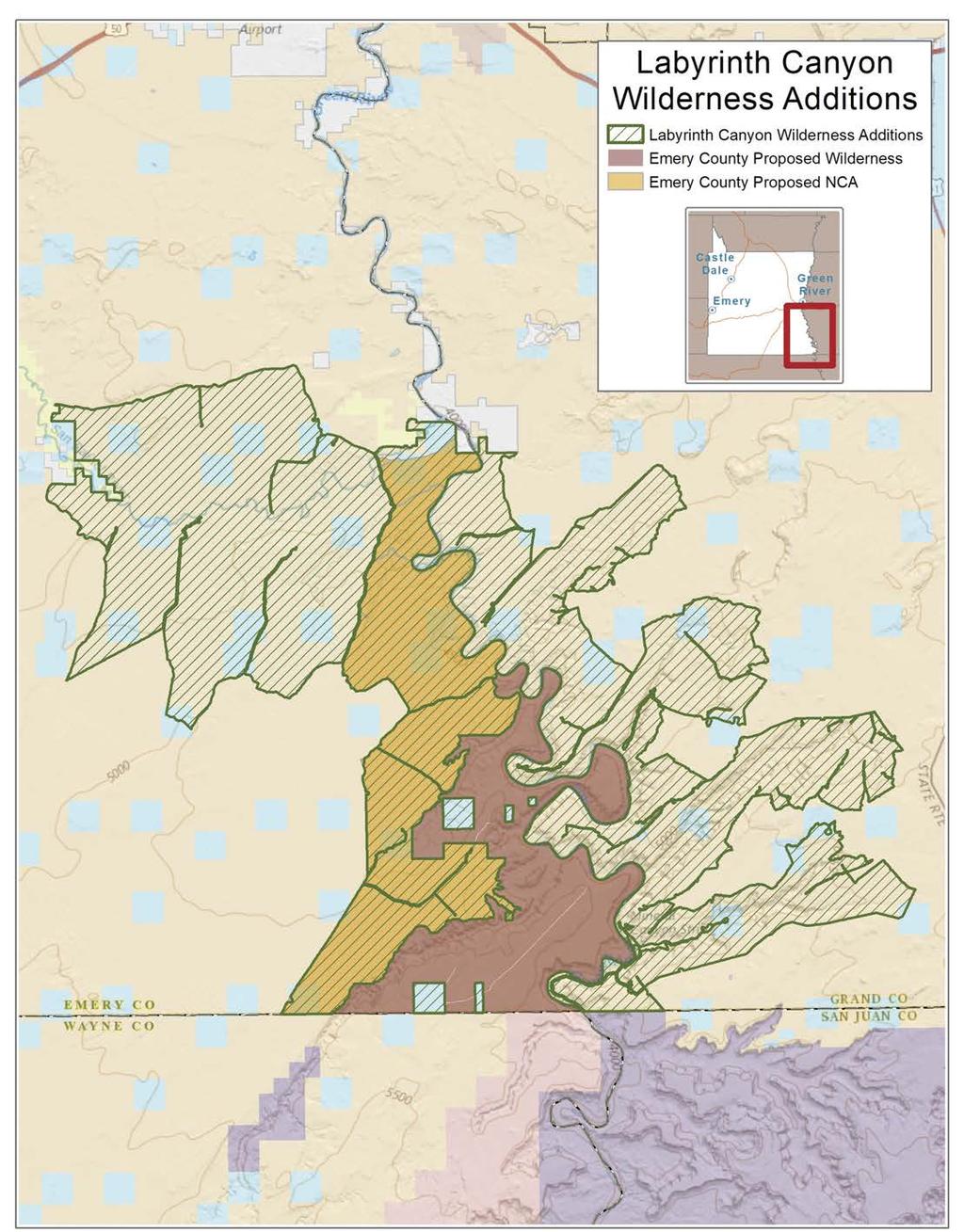
12 Labyrinth Canyon Wilderness Addition / Photo by Neal Clark LABYRINTH CANYON WILDERNESS ADDITION 12
13 THERE IS AN EXQUISITE CHARM IN OUR RIDE TO-DAY DOWN THIS BEAUTIFUL CANYON. IT GRADUALLY GROWS DEEPER WITH EVERY MILE OF TRAVEL; THE WALLS ARE SYM- METRICALLY CURVED AND GRANDLY ARCHED, OF A BEAUTIFUL COLOR, AND REFLECTED IN THE QUIET WATERS IN MANY PLACES SO AS ALMOST TO DECEIVE THE EYE AND SUGGEST TO THE BEHOLDER THE THOUGHT THAT HE IS LOOKING INTO PROFOUND DEPTHS WE NAME THIS LABYRINTH CANYON. JOHN WESLEY POWELL, 1869 Highlights The Labyrinth Canyon of today differs little from the wilderness landscape described by John Wesley Powell during his famous 1869 expedition down the Green and Colorado Rivers. This world-class stretch of flat water unbroken by rapids or falls on its 50-mile journey from Red Wash near Trin-Alcove Bend to Canyonlands National Park offers spectacular opportunities for quiet recreation and sightseeing, provides critical wildlife and plant habitat, and contains a wealth of prehistoric cultural resources. Cutting its way through towering walls of Navajo Sandstone, Labyrinth Canyon s endless series of bowknot curves contain unique riparian habitat and incomparable side canyons Spring, Hell Roaring, Three, Keg Spring, Horseshoe, Hey Joe, Mineral, and Ten Mile. Recognized the world over for its geological and archaeological wonders and quiet recreation opportunities, Labyrinth Canyon is truly a unique wilderness landscape. Biological Community Like its geology, the biological resources of Labyrinth Canyon and its side canyons are rich and diverse. Many species of fish, waterfowl, reptiles, and mammals call this place home. Deer graze among willows along the river, beaver glide across lagoons at the mouth of side canyons, and a dozen species of fish including the endangered Colorado pikeminnow, bonytail chub, and humpback chub live in the river. Coyote, bobcat, fox, and desert bighorn sheep roam the side canyons and benchlands. Hawks, vultures, golden eagles, and peregrine falcons share the updrafts, and pronghorn antelope graze among the dunes and slickrock domes found along the canyon rims. Cultural Resources Deep in Horseshoe Canyon, a 35-milelong side canyon of Labyrinth Canyon, lies the Great Gallery, one of the most significant prehistoric rock art sites in North America. Although a 2,500-acre National Park Service unit protects the site, the rest of the canyon including less well-known pictograph panels remains unprotected. Elsewhere in the Labyrinth Canyon system, archeologists have discovered human artifacts nearly 9,000 years old. Labyrinth Canyon is also home to early pioneer sites, historic mines, and engravings from early explorers to the region. Recreation With nearly 50 miles of smooth water unbroken by rapids or falls, Labyrinth Canyon is a river runner s paradise. Cutting a path through Navajo Sandstone on its way towards the confluence with the Green River in Canyonlands National Park, the canyon and its tributaries are riddled with alcoves and caves, natural bridges, and towering cliff faces. River runners enjoy the sight of Navajo Sandstone cliffs gradually rising out the flat-lying deserts as they float down the smooth waters of the Green River. By Trin-Alcove Bend, the cliffs become an imposing barrier to overland travel, although additional access points can be found at Ten Mile, Spring, Hell Roaring, and Horseshoe Canyons. Above the canyons, rolling benchlands culminate in dramatic overlooks of the river. By the time the river reaches Canyonlands National Park, the cliffs of Wingate Sandstone are exposed high above. The side canyons of Spring, Hell Roaring, Three, Keg Spring, Horseshoe, Hey Joe, Mineral, and Ten Mile also provide an array of quiet recreation opportunities. From technical canyoneering routes to daylong hikes in search of swimming holes and hanging gardens, Labyrinth Canyon provides an accessible multi-day wilderness river experience for families, beginners, and experts alike. Emery County Public Lands Management Act of 2018 While the Emery County Public Lands Management Act of 2018 protects a portion of the western side of Labyrinth Canyon as designated Wilderness, the legislation fails to ensure lasting protection for this entirety of this quiet recreation Eden. Without the clear protection afforded by the Wilderness Act, the wilderness-quality of Labyrinth Canyon will be lost to off-road vehicle abuse and energy development. In order to protect the unparalleled solitude of Labyrinth Canyon for all future generations, the legislation must: Protect the entirety of Labyrinth Canyon and its side canyons within both Emery and Grand Counties as designated Wilder- 13

14 ness from Red Wash down to Canyonlands National Park. The current proposal, drawn on arbitrary political boundaries, fails to recognize Labyrinth Canyon as one intact landscape protecting only a fraction of Labyrinth Canyon as designated Wilderness and omitting the eastern side of the canyon system entirely. In order to ensure lasting solitude and wildness within the canyon system, the legislation must protect the eastern side of Labyrinth Canyon and its side canyons (Ten Mile, Spring, Hell Roaring, Hey Joe, and Mineral) as designated Wilderness. The legislation must also designate the western portion that is currently proposed as an NCA by Emery County as Wilderness. Protecting only portions of the western rim of Labyrinth Canyon in Emery County fails to give the canyon system the lasting protection it deserves; makes little sense for conserving the primitive, wilderness river experience; and creates a bizarre and difficult land management situation. Compared to the Emery County proposal, protecting all of Labyrinth Canyon would add approx. 138,000 acres of designated Wilderness to the legislation (92,740 acres in Emery County and 45,025 acres in Grand County). Labyrinth Canyon Wilderness Addition / Photo Tom Till Not open currently closed motorized routes. This includes June s Bottom, which runs from the western rim of Labyrinth Canyon to the river. If opened, the June s Bottom route would allow motorized vehicles into the river corridor, adversely impacting the river s solitude and primitive recreation experience. Permanently close all motorized routes along the Green River in Labyrinth Canyon. This includes the Hey Joe, Ten Mile Wash, and Hell Roaring Canyon motorized routes, and the motorcycle routes known as The Tubes and Dead Cow Wash. There are hundreds of motorized trails located elsewhere in this region available for such use; however, there is no alternative to Labyrinth Canyon for quiet river recreation. As designated Wilderness, these areas should be protected from the noise, dust, and pollution from motorized use along the Green River. There is simply no compelling reason to continue allowing motorized use to negatively impact this wilderness treasure. 14
15 15

16 San Rafael Badlands NCA / Photo Jonathan Bailey SAN RAFAEL BADLANDS NATIONAL CONSERVATION AREA 16
17 WILDERNESS IS NOT A LUXURY BUT A NECESSITY OF THE HUMAN SPIRIT, AND AS VITAL TO OUR LIVES AS WATER AND GOOD BREAD. A CIVILIZATION WHICH DESTROYS WHAT LITTLE REMAINS OF THE WILD, THE SPARE, THE ORIGINAL, IS CUTTING ITSELF OFF FROM ITS ORIGINS AND BETRAY- ING THE PRINCIPLE OF CIVILIZA- TION ITSELF. EDWARD ABBEY, 1968 Highlights The western reach of the San Rafael Swell, known as the San Rafael Badlands, holds a diversity of landscapes rich in cultural resources, scenic vistas, and geologic wonders. Composed of Molen Reef, Eagle Canyon, Rock Canyon, Cedar Mountain, and the Mussentuchit Badlands (pronounced mustn t touch it ), this rugged landscape is studded with mesas, buttes, and igneous intrusions painted with a brilliant kaleidoscope of desert colors. Historically drawing hikers and sightseers for its stark and vast beauty, recent discoveries of rock art in addition to well-known panels have also increased interest in the area. The area s abundance of known and yet-to-bediscovered cultural resources, along with recreational opportunities, have caused the Hopi Tribe, along with conservation, recreation, and archeological groups, to challenge oil and gas leasing here in recent years. Biological Community A classic badlands ecosystem, occasionally interrupted by the riparian vegetation of Muddy Creek and other springs, sparse desert shrubs and grasses typify the San Rafael Badlands. Two federally listed endangered species of cacti, the San Rafael cactus (Pediocactus despainii) and the Winkler s pincushion cactus (Pediocactus winkleri), are found within the Morrison Formation of the San Rafael Badlands. Cultural Resources For millennia, humans have occupied and travelled through the San Rafael Badlands, contributing to one of the most significant archaeological and cultural records available to the public. As a whole, this region paints a vivid picture of the First Americans from plants used for food, medicine, and religious purposes, to culturally-saturated topography marked by rivers, intermittent water sources, migratory routes, and overlooks. The significance of these features is abundantly written in the landscape in the form of rock art, habitation sites, stone working sites, burials, and places in which grain was stored. As the San Rafael Badlands have never been subject to comprehensive archaeological study, the potential for undiscovered sites is simply stunning. Since 2013, upwards of 250 new and significant cultural sites have been discovered in the Molen Reef area alone. The Hopi Tribe claims cultural affiliation to prehistoric Paleoindian, Archaic, Basketmaker, Anasazi, and Fremont prehistoric cultural groups associated with the San Rafael Badlands, and has actively worked to challenge oil and gas leasing in this region. This area has also been the focus of gypsum mining development. Recreation The San Rafael Badlands provide an array of recreational opportunities for the intrepid explorer. Called a photographer s heaven in guidebooks and other publications, the San Rafael Badlands is where the extraordinary 70-mile kayak trip to the Dirty Devil River begins on Muddy Creek, an outstanding desert river that in high water years provides rocky rapids in a setting of incredible scenery and isolation. Constantly changing in form and topography, with hundreds of draws, ravines, and gullies, the challenge becomes finding your way through the maze of such a complex landscape. Whether it s photography, kayaking, scenic and geologic sightseeing, photography, extended hiking, or study of cultural resources, the San Rafael Badlands provides a stark, adventurous recreational experience unlike that found in many other regions of the desert Southwest. Emery County Public Lands Management Act of 2018 The Emery County Public Lands Management Act of 2018 fails to protect any the sensitive landscapes of the San Rafael Badlands. In order to protect this remote and rugged cultural and natural treasure, the legislation must: Designate the San Rafael Badlands as the San Rafael Badlands National Conservation Area. The 200,100-acre National 17


18 Conservation Area (NCA) should be designated to conserve, protect, and enhance for the benefit and enjoyment of present and future generations the cultural, ecological, wildlife, natural, scenic, educational, and scientific resources of the NCA. The NCA utilizes manageable boundaries following human impacts or topographic features and is drawn to ensure that the irreplaceable cultural and natural resources of this region are protected. The NCA should utilize precedential language from the 2009 Washington County legislation. San Rafael Badlands NCA / Photo by Ray Bloxham Include a mineral withdrawal for the entire San Rafael Badlands NCA. A mineral withdrawal will ensure that this culturallysensitive region is protected from oil, gas, and mining development. San Rafael Badlands NCA / Photo by Ray Bloxham 18

19 19


20 Muddy Creek Wilderness Addition / Photo by Ray Bloxham Muddy Creek Wilderness Addition / Photo by Ray Bloxham Labyrinth Canyon Wilderness Addition / Photo by Ray Bloxham Labyrinth Canyon Wilderness Addition / Photo Tom Till San Rafael Badlands NCA / Photo by Ray Bloxham San Rafael Badlands NCA / Photo by Ray Bloxham 20

21 21

22 22 Labyrinth Canyon Wilderness Addition / Photo by Ray Bloxham

23 23
 546-2215 Moab P.O.")
24 San Rafael Reef / Cover Photo by Bill Church Salt Lake City 425 East 100 South Salt Lake City, UT (801) Washington, DC 122 C Street NW Suite 240 Washington, DC (202) Moab P.O. Box 968 Moab, UT (435)
EMERY COUNTY PUBLIC LAND MANAGEMENT ACT OF 2018 S. 2809/H.R. 5727
 EMERY COUNTY PUBLIC LAND MANAGEMENT ACT OF 2018 S. 2809/H.R. 5727 September 25, 2018 OVERVIEW The Emery County Public Land Management Act of 2018 is a significant step backwards for wilderness and conservation
Written Testimony of Neal Clark Wildlands Program Director Southern Utah Wilderness Alliance on behalf of the Utah Wilderness Coalition
 Written Testimony of Neal Clark Wildlands Program Director Southern Utah Wilderness Alliance on behalf of the Utah Wilderness Coalition Before the House Committee on Natural Resources Subcommittee on Federal
National Parks and Beyond
 National Parks and Beyond Canyons, Mesas and Hoodoos Nevada Utah Arizona Red Rock Canyon National Conservation Area Las Vegas, Nevada Begin your adventure under the neon lights of Las Vegas, an oasis in
BRYCE CANYON COUNTRY. A twisted tree endures rugged life on the rim of the Paunsaugunt Plateau.
 BRYCE CANYON COUNTRY Grand Staircase - Paunsaugunt Plateau Scenic backways itinerary A twisted tree endures rugged life on the rim of the Paunsaugunt Plateau. Travel to Bryce Canyon Country. Lodging check-in,
Bryce Canyon Country.
 Bryce Canyon Country Backways Itinerary - Grand Staircase, Capitol Reef Region Grand Staircase/Capitol Reef/Henry Mountains Adventure off the beaten path and revel in the beauty of Utah s scenic backways.
2.0 PARK VISION AND ROLES
 2.0 PARK VISION AND ROLES 2.1 Significance in the Protected Area System Marble Range and Edge Hills provincial parks protect 6.8% of the Pavillion Ranges Ecosection, which is located in the Southern Interior
Utah. Mexican Mountain Wilderness Study Area Site-Specific Monitoring Guide
 Utah Mexican Mountain Wilderness Study Area Site-Specific Monitoring Guide 1 General Information WildSNAP Monitoring Peter Woodruff, American Conservation Experience Coordinator Phone (801) 989-7069 Main
Bureau of Land Management Public Lands Guide Northwest District
 Bureau of Land Management Public Lands Guide Northwest District NORTHWEST Fee Site Restrooms Picnic Sites Developed Campgrounds Farmington Field Office (505) 564-7600 Alien Run Mountain Bike Trail Angel
April 10, Mark Stiles San Juan Public Lands Center Manager 15 Burnett Court Durango, CO Dear Mark,
 Mark Stiles San Juan Public Lands Center Manager 15 Burnett Court Durango, CO 81301 Dear Mark, We are pleased to offer the following comments on the draft San Juan Public Lands Center management plans
26 Utah s Patchwork Parkway SCENIC BYWAY CORRIDOR MANAGEMENT PLAN (SR 143)
") Natural Natural Quality applies to those features in the visual environment that are in a relatively undisturbed state. These features predate the arrival of human populations and may include geological
Natural Natural Quality applies to those features in the visual environment that are in a relatively undisturbed state. These features predate the arrival of human populations and may include geological
BRYCE CANYON COUNTRY Boulder Mountain Scenic backways itinerary
 BRYCE CANYON COUNTRY Boulder Mountain Scenic backways itinerary Boulder Mountain Area The high plateaus of the Aquarius Plateau (Boulder Mountain), are heavily forested and covered in countless winding
Dreamscapes of the American Southwest. Las Vegas to Salt Lake City
 Dreamscapes of the American Southwest Las Vegas to Salt Lake City Day 1: Grand Canyon National Park and Lake Powell Premium Lodging: Lake Powell Resort: Page, AZ Departing from Las Vegas, our journey will
Lewis and Clark National Historic Trail
 National Trails System Land and Water Conservation Fund FY2014 Lewis and Clark National Historic Trail Total LWCF Request: $ 3,130,000 Project Name Agency District # Tracts Acres Total Cost Columbia River
discover Genuine Montana The Last Best Place Great Falls Montana
 discover Genuine Montana The Last Best Place Great Falls Montana the grandest sight I ever beheld... 1805 Meriwether Lewis journal entry Resting on the high plains along Montana s Rocky Mountain Front
Range Creek Rock Art, The First Year
 Steven J. Manning Range Creek Rock Art, 2002. The First Year The purpose of this paper is to report the findings of an archaeological reconnaissance inventory conducted in August 2002 on the Waldo Wilcox
UTAH S NATIONAL PARK TOUR
 UTAH S NATIONAL PARK TOUR DAY 1 Each client needs to check in any time at the fabulous Aria Hotel located in the heart of Las Vegas. We will meet at 6pm for a one hour orientation explaining the schedule
Wyoming Public Lands Initiative in Carbon County
 Wyoming Public Lands Initiative in Carbon County THE CARBON COUNTY WPLI ADVISORY COMMIT TEE WANTS YOUR INPUT Wilderness Study Area: A special designation that applies to lands managed to protect wilderness
5.0 OUTDOOR RECREATION OPPORTUNITIES AND MANAGEMENT
 5.0 OUTDOOR RECREATION OPPORTUNITIES AND MANAGEMENT 5.1 Introduction This section describes the range of recreational activities that currently take place in Marble Range and Edge Hills Parks, as well
Around Page, Arizona and Southeastern Utah (U17A Part 1)
") Around Page, Arizona and Southeastern Utah (U17A Part 1) For a two-week hiking and sightseeing trip centered on Utah and the Colorado Plateau area, I began with repeat stays in Page, Arizona and Monticello,
Around Page, Arizona and Southeastern Utah (U17A Part 1) For a two-week hiking and sightseeing trip centered on Utah and the Colorado Plateau area, I began with repeat stays in Page, Arizona and Monticello,
2.0 Physical Characteristics
 _ 2.0 Physical Characteristics 2.1 Existing Land Use for the Project The site is comprised of approximately 114 acres bounded by Highway 101 to the north, the existing town of Los Alamos to the east, State
A. GENERAL COMMENTS:
 COMMENTS ON THE MONTICELLO FIELD OFFICE BLM DRAFT RESOURCE MANAGEMENT PLAN AND ENVIRONMENTAL IMPACT STATEMENT (NOVEMBER 2007) Submitted by: Jean Binyon on behalf of the Glen Canyon Group of the Utah Chapter
FINAL TESTIMONY 1 COMMITTEE ON RESOURCES UNITED STATES HOUSE OF REPRESENTATIVES. July 13, 2005 CONCERNING. Motorized Recreational Use of Federal Lands
 FINAL TESTIMONY 1 STATEMENT OF DALE BOSWORTH CHIEF Of the FOREST SERVICE UNITED STATES DEPARTMENT OF AGRICULTURE Before the SUBCOMMITTEE ON FORESTS AND FOREST HEALTH And the SUBCOMMITTEE ON NATIONAL PARKS,
ANGEL PEAK SCENIC AREA
 Activities: Facilities: ANGEL PEAK SCENIC AREA Hiking, photography, watchable wildlife, camping, picnicking. Note: While formal hiking trails in the area are limited, dispersed hiking opportunities abound
SIMON CANYON AREA OF CRITICAL ENVIRONMENTAL CONCERN (ACEC)
") SIMON CANYON AREA OF CRITICAL ENVIRONMENTAL CONCERN (ACEC) Activities: Facilities: Season / Hours: Description: Hiking, backpacking, fishing, picnicking, watchable wildlife. A graveled parking area, picnic
SIMON CANYON AREA OF CRITICAL ENVIRONMENTAL CONCERN (ACEC) Activities: Facilities: Season / Hours: Description: Hiking, backpacking, fishing, picnicking, watchable wildlife. A graveled parking area, picnic
BUCK POINT RANCH. Aspen Associates Realty
 BUCK POINT RANCH Aspen Associates Realty www.aspenassociatesrealty.com 970.544.5800 WELCOME TO Buck Point Ranch is a 960± acre property located in one of the last pristine valleys in close proximity to
Special Recreation Management Areas Extensive Recreation Management Areas Public Lands Not Designated as Recreation Management Areas
 From the Proposed RMP: Special Recreation Management Areas SRMAs are an administrative unit where the existing or proposed recreation opportunities and recreation setting characteristics are recognized
Comanche National Grassland, Timpas Unit
 Comanche National Grassland, Timpas Unit Heritage Resources More than 540 sites are eligible for listing on the National Register of Historic Places (NRHP) by Forest Service staff and/or the Colorado State
Washakie Wilderness Ranch
 Washakie Wilderness Ranch Dubois, Wyoming Fly Fishing Hunting Ranching Conservation Washakie Wilderness Ranch Dubois, Wyoming Introduction: A stunning 160-acre parcel located at the base of the Ramshorn
Ranch. Creek. Cow. Mountain
 Cow Creek Mountain Ranch Situated along the southwestern hills of the Laramie Mountains and the Medicine Bow-Routt National Forest in northeastern Albany County, Wyoming. 58 E. Benteen Street Buffalo,
TAYLOR CANYON RANCH COLORADO - ROUTT COUNTY - STEAMBOAT SPRINGS
 TAYLOR CANYON RANCH COLORADO - ROUTT COUNTY - STEAMBOAT SPRINGS Tucked up against the steep valley shaped by Mt. Pau and rising to the Routt National Forest, Taylor Canyon Ranch is an easily accessible,
Long's Travel Service presents. Canyon Country. featuring Arizona & Utah. October 8 15, 2019
 Long's Travel Service presents Canyon Country featuring Arizona & Utah October 8 15, 2019 Book Now & Save $ 100 Per Person or more information contact Michael Holland Long's Travel Service (973) 538-1700
Dreamscapes of the American Southwest Salt Lake City to Las Vegas
 Dreamscapes of the American Southwest Salt Lake City to Las Vegas Day 1: Arches National Park Premium Lodging: The Sorrel River Resort and Spa: Moab, UT We will depart from Salt Lake City at 10 AM for
(Short Listing) DUPUYER ACREAGE, ROCKY MOUNTAN FRONT
 DUPUYER ACREAGE, ROCKY MOUNTAN FRONT") (Short Listing) DUPUYER ACREAGE, ROCKY MOUNTAN FRONT This unique property is located 8½ miles northwest of Dupuyer, Montana and approximately thirty 30 miles northwest of Choteau, Montana. Great Falls
(Short Listing) DUPUYER ACREAGE, ROCKY MOUNTAN FRONT This unique property is located 8½ miles northwest of Dupuyer, Montana and approximately thirty 30 miles northwest of Choteau, Montana. Great Falls
Frazier Canyon Ranch 3,020 Acres Jeff Davis County, Texas
 Frazier Canyon Ranch 3,020 Acres Jeff Davis County, Texas James King, Agent Office 432 426.2024 Cell 432 386.2821 James@KingLandWater.com Frazier Canyon Ranch 3,020 acres Jeff Davis County, Texas James
Decision Memo for Desolation Trail: Mill D to Desolation Lake Trail Relocation
 for Salt Lake County, Utah Uinta-Wasatch-Cache National Forest Salt Lake Ranger District 1. Background The present location of the Desolation Trail (#1159) between Mill D and Desolation Lake follows old
$850,000 Awarded to 20 Organizations
 $850,000 Awarded to 20 Organizations The Conservation Alliance is pleased to fund the following organizations to support their efforts to protect wild lands and waterways for their habitat and recreation
Greening Project Status Report: Grand Canyon National Park
 Greening Project Status Report: Grand Canyon National Park Prepared for the Federal Energy Management Program U.S. Department of Energy February 2001 iii Contents Page 1. Introduction... 1 2. Context of
Subject to sale, withdrawal, or error.
 The Crawford L Bar Ranch is located approximately 40 air miles west of Albuquerque, New Mexico. This ranch truly epitomizes the description of New Mexico being the Land of Enchantment. The topography and
COLORADO TRAIN ADVENTURE
 COLORADO TRAIN ADVENTURE by Melody Hagerman at Travel the Horizon Summary Traveling by rail in Colorado is the most spectacular way to take in its unique scenery. From high above the tracks, you'll enjoy
1 Permanent Full Time Forester GS /07/09 Kaibab National Forest Duty Station: Williams or Tusayan, AZ
 1 Permanent Full Time Forester GS-460-05/07/09 Kaibab National Forest Duty Station: Williams or Tusayan, AZ Merit Vacancy Announcement: Open Monday January 11 th to Friday January 20 th 2016 and working
MOAB peopleforbikes.org/e-bikes
 emtb ADVENTURE MAPS MOAB peopleforbikes.org/e-bikes OVERVIEW Moab, Utah is a world-class mountain bike destination known for its vast, red sandstone landscapes nestled below the rising peaks of the La
PROTECTING ARIZONA S NATURAL AND CULTURAL LEGACY FOR FUTURE GENERATIONS
 PROTECTING ARIZONA S NATURAL AND CULTURAL LEGACY FOR FUTURE GENERATIONS From prehistoric times to the present, this region has always been a signifi cant travel corridor a cultural crossroads. - Andy Laurenzi,
Superintendent David Uberuaga June 27, 2011 Grand Canyon National Park P.O. Box 129 Grand Canyon, AZ 86023
 Superintendent David Uberuaga June 27, 2011 Grand Canyon National Park P.O. Box 129 Grand Canyon, AZ 86023 Dear Superintendent Uberuaga, Thank you for the opportunity to provide scoping comments on Grand
Pinellas County Environmental Lands
 Pinellas County Environmental Lands In addition to traditional parks and recreation facilities, Pinellas County owns and manages a system of environmental lands that provides specialized resource-based
TESTIMONY OF DR. THOMAS C. O KEEFE, AMERICAN WHITEWATER
 TESTIMONY OF DR. THOMAS C. O KEEFE, AMERICAN WHITEWATER UNITED STATES HOUSE OF REPRESENTATIVES SUBCOMMITTEE ON NATIONAL PARKS, FORESTS AND PUBLIC LANDS OF THE COMMITTEE ON NATURAL RESOURCES HEARING ON
Goldbar. Hell Roaring Canyon
 1 Goldbar Upper left: Goldbar Canyon, a BLM Roadless Area, is a popular hiking area near Moab. Motorized use in this area causes significant conflicts with traditional nonmotorized recreationists. Above
Securing Permanent Protection for Public Land
 Securing Permanent Protection for Public Land Tools for Wyoming Advocates Paul Spitler* The Wilderness Society * I am a wilderness policy expert, not a powerpoint expert! Platform and Resolutions of the
Mills Pecos River Ranch 7800 Acres Val Verde County, Texas Situated along both sides of the Pecos River
 Mills Pecos River Ranch 7800 Acres Val Verde County, Texas Situated along both sides of the Pecos River James King, Agent Office 432-426-2024 Cell 432-386-2821 James@KingLandWater.com King Land & Water
The following criteria were used to identify Benchmark Areas:
 7.0 BENCHMARK AREAS The Churn Creek Protected Area offers a significant opportunity to learn more about how grassland ecosystems function. One of the key tools that will be used to monitor larger grassland
Course Description. Southwest alpine Backpacking, canyoneering & River Expedition 24 days
 Course Description Southwest alpine Backpacking, canyoneering & River Expedition 24 days In General Congratulations! This is one of the marquee courses that Outward Bound offers. There is no other course
CHIMNEY ROCK ARCHEOLOGICAL AREA
 CHIMNEY ROCK ARCHEOLOGICAL AREA Phone U.S. Forest Service, Pagosa Springs, Colorado at (303) 264-2268 for tour reservations and information SAN JUAN NATIONAL FOREST PAGOSA RANGER DISTRICT, ARCHULETA COUNTY,
STORNETTA BROTHERS COASTAL RANCH
 STORNETTA BROTHERS COASTAL RANCH Location: Surrounding Point Arena Lighthouse and immediately south of Manchester State Park Mendocino Co., CA Acres: 1,860 Resources: Over two miles of Pacific Ocean coastline
Arches of the. Sandflats Area. By Virginia Allen
 Arches of the Sandflats Area By Virginia Allen TABLE OF CONTENTS Introduction Dedication Road Log Arches 1. Perforated View Arch 2. Fee Booth Arch 3. Windsong Arch 4. Weird Arch 5. Resting Arch 6. Bike
Colorado Life Zone Scavenger Hunt
 Colorado Life Zone Scavenger Hunt Below are worksheets created for all the habitats or life zones. They were designed with the intention of breaking the class up into small groups, and having students
Swan Valley Farms. 523 acres for sale in Bonneville County, ID JIMMY ROUMANIS. JOHN STARR
 Swan Valley Farms JOHN STARR 208 472 2838 john.starr@colliers.com 523 acres for sale in Bonneville County, ID JIMMY ROUMANIS 208 472 2840 jimmy.roumanis@colliers.com Swan Valley Farms- 523 acres for sale
Proposed Lands With Wilderness Characteristics: STEWART CANYON. Public Lands in Greenlee County, Arizona
 Proposed Lands With Wilderness Characteristics: STEWART CANYON Public Lands in Greenlee County, Arizona A proposal report to the Bureau of Land Management, Safford Field Office, Arizona February, 2018
Hole in the Rock Scenic Backway
 Hole in the Rock Scenic Backway The Hole in the Rock Scenic Backway leads one along the pioneer path created by a Mormon Expedition. Approximately 55 miles one-way from Highway 12 to the Hole-inthe-Rock,
Whychus-Deschutes Wilderness Proposal
 Whychus-Deschutes Wilderness Proposal Imagine a place where two pristine waterways meet in a deep, rugged canyon. Where cool, clear water rushes from ancient springs to provide the lifeblood for wildlife
* Enjoy the Southwest: dry and on the rocks * 11 DAYS OF AMERICA S NATURAL WONDERS MAY 23 JUNE 2, 2015
 MAY 23 JUNE 2, 2015 Special Alumni Rate SAVE more than $600 per couple Southwest National Parks 11 DAYS OF AMERICA S NATURAL WONDERS * Enjoy the Southwest: dry and on the rocks * Southwest National Parks
Monday, January 22, Volume 37, Issue 3; ISSN:
 Monday, January 22, 2001 Volume 37, Issue 3; ISSN: 0511-4187 Proclamation 7398--establishment of the Upper Missouri River Breaks National Monument William J Clinton January 17,2001 By the President of
Moon Arches & Canyonlands National Parks (Moon Handbooks) By Bill McRae, Judy Jewell READ ONLINE
 By Bill McRae, Judy Jewell READ ONLINE") Moon Arches & Canyonlands National Parks (Moon Handbooks) By Bill McRae, Judy Jewell READ ONLINE Fodor s Travel Publications; Fodor's Travel Guides; Fodor's Travel; Edition no. 5 Fol Pap/ Moon Arches &
Moon Arches & Canyonlands National Parks (Moon Handbooks) By Bill McRae, Judy Jewell READ ONLINE Fodor s Travel Publications; Fodor's Travel Guides; Fodor's Travel; Edition no. 5 Fol Pap/ Moon Arches &
Children's Discovery Trail Guide - Lost Creek
 Children's Discovery Trail Guide - Lost Creek Thank you for spending time learning and observing some of the secrets of Red Rock Canyon Conservation Area has to offer. Feel free to talk to a ranger if
Internet TripTik. From : Zion National Park, Ut Stop At Stop At Stop At Stop At Stop At. : Bryce Canyon National Park, Ut : Arches National Park, Ut
 MAP: Overview Internet TripTik From : Zion National Stop At Stop At Stop At Stop At Stop At To : Bryce Canyon National Park, Ut : Arches National : Canyonlands National : Monument Valley, Utah : Kayenta,
MODIFYING THE BEARS EARS NATIONAL MONUMENT BY THE PRESIDENT OF THE UNITED STATES OF AMERICA A PROCLAMATION
 This document is scheduled to be published in the Federal Register on 12/08/2017 and available online at https://federalregister.gov/d/2017-26709, and on FDsys.gov MODIFYING THE BEARS EARS NATIONAL MONUMENT
Base Camp Las Vegas: Hiking The Southwestern States By Deborah Wall READ ONLINE
 Base Camp Las Vegas: Hiking The Southwestern States By Deborah Wall READ ONLINE Base Camp Las Vegas: 101 Hikes in the Southwest [Deborah Wall] on Amazon. com. *FREE* shipping Base Camp Las Vegas: Hiking
Namibia. Land of the Desert
 Namibia Land of the Desert Namibia is a destination like no other. It has three hundred days of sunshine per year, some of the most beautiful landscapes on the continent, remote and largely unexplored
Hartsel Springs Ranch 4,637 Acres Park County, Colorado $4,780,000
 Hartsel Springs Ranch 4,637 Acres Park County, Colorado $4,780,000 Presented By: Farm, Ranch & Recreational Real Estate Hartsel Springs Ranch 4,637 Acres Park County, Colorado $4,780,000 Property Description
Ortiz River Ranch Pagosa Springs, Colorado
 Ortiz River Ranch Pagosa Springs, Colorado This ranch provides an exceptional opportunity to own a property with frontage on the San Juan and Navajo Rivers, lush irrigated pastures, and beautiful rolling
B HALL RANCH FISHTAIL, MONTANA
 Brochure Courtesy of: B HALL RANCH FISHTAIL, MONTANA w w w. m c c a s l i n l a n d. c o m Page 1 LOCATION The Hall Ranch is ideally located in the foothills of the Beartooth Mountains, approximately 5
MAINTENANCE OF THE PRIMEVAL IN NATIONAL PARKS By Arno B. Cammerer Director, National Park Service
 MAINTENANCE OF THE PRIMEVAL IN NATIONAL PARKS By Arno B. Cammerer Director, National Park Service The term "park" has been applied so long to a man-made area planted to vegetation that it is sometimes
Proposed Lands With Wilderness Characteristics: HOVERROCKER Public Lands in Greenlee County, Arizona
 Proposed Lands With Wilderness Characteristics: HOVERROCKER Public Lands in Greenlee County, Arizona A proposal report to the Bureau of Land Management, Safford Field Office, Arizona February, 2018 Prepared
Continental Divide National Scenic Trail Legislative History and Planning Guidance
 Continental Divide National Scenic Trail Legislative History and Planning Guidance Legislation, Policy, and Direction Regarding National Scenic Trails The National Trails System Act, P.L. 90-543, was passed
Our Mission. Discover the many states of California. Chino Hills State Park 1879 Jackson Street Riverside, Ca (951)
") Chino Hills State Park Our Mission The mission of the California Department of Parks and Recreation is to provide for the health, inspiration and education of the people of California by helping to preserve
Chino Hills State Park Our Mission The mission of the California Department of Parks and Recreation is to provide for the health, inspiration and education of the people of California by helping to preserve
Stagecoach Ranch. Colorado - Fremont County - Texas Creek 1
 Stagecoach Ranch Selected for the classic western film Cat Ballou, the Stagecoach Ranch features lush meadows, rock outcroppings, foothills, and 1 1/2 miles of Texas Creek in a picturesue setting with
General Overview: Acreage:
 General Overview: The Beaver Creek Ranch is located on Beaver Creek in Shell Wyoming, at the base of the western slope of the Big Horn Mountains, one of the west s most spectacular back drops. With an
LANDS WITH WILDERNESS CHACTERISTICS
 LANDS WITH WILDERNESS CHACTERISTICS A hiking guide for Ten BLM roadless areas inventoried by Wild Connections Each area description includes a summary of BLM s inventory for wilderness characteristics,
Kwadacha Wilderness Provincial Park and Kwadacha Addition (Kwadacha Recreation Area) Purpose Statement and Zoning Plan
 Purpose Statement and Zoning Plan") Kwadacha Wilderness Provincial Park and Kwadacha Addition (Kwadacha Recreation Area) Purpose Statement and Zoning Plan Located in a remote area of the northern interior of BC, this large park straddles
Kwadacha Wilderness Provincial Park and Kwadacha Addition (Kwadacha Recreation Area) Purpose Statement and Zoning Plan Located in a remote area of the northern interior of BC, this large park straddles
CIRCLE THE AMERICAN WEST
 CIRCLE THE AMERICAN WEST 15 Day Tour from Denver to Denver May 31- June 14, 2019 Mother Nature has loaded the West with stunning scenery, and on this National Parks tour, you ll witness some of natures
Proposed Lands With Wilderness Characteristics: Gila Box Public Lands in Graham and Greenlee Counties, Arizona
 Proposed Lands With Wilderness Characteristics: Gila Box Public Lands in Graham and Greenlee Counties, Arizona A proposal report to the Bureau of Land Management, Safford Field Office, Arizona March, 2018
Lecture 08, 22 Sep 2003 Role Playing. Conservation Biology ECOL 406R/506R University of Arizona Fall Kevin Bonine
 Lecture 08, 22 Sep 2003 Role Playing Conservation Biology ECOL 406R/506R University of Arizona Fall 2003 Kevin Bonine 1. Role Playing Exercise 2. Exam Wed -group portion outside - ~40 minutes individual,
UTAH 2016 CANYONLANDS
 UTAH 2016 CANYONLANDS THE WHITE RIM TRAIL MAY 17, 2016 We left the cabin at 7:30 a.m. The goal was to get to Great Basin National Park that night. We took Highway 6 towards Tonopah and decided to go north
Blanco Creek Ranch Acres, Uvalde County, Texas
 Blanco Creek Ranch 1208.30 Acres, Uvalde County, Texas James King, Agent Office 432 426.2024 Cell 432 386.2821 James@KingLandWater.com Blanco Creek Ranch 1208.30 acres Uvalde County, Texas James King,
BUTCHER CREEK RANCH. Butcher Creek Ranch. Roscoe, Montana. Reduced to $1,650,000.
 BUTCHER CREEK RANCH Butcher Creek Ranch Roscoe, Montana Reduced to $1,650,000. Offered Exclusively By: Sonny Todd Real Estate 301 West First Avenue, PO Box 788 Big Timber, Montana 59011 Office: (406) 932-1031
A Public Lands Overview
 A Public Lands Overview At birth or upon taking the oath of citizenship, every American inherits 623 million acres. This natural legacy includes some of the most stunning places on Earth: the Grand Canyon,
Connie Rudd Superintendent, Black Canyon of the Gunnison National Park
 National Park Service U.S. Department of the Interior Black Canyon of the Gunnison National Park and Curecanti National Recreation Area Information Brochure #1 Wilderness and Backcountry Management Plan
Exploring the Great Southwest
 8 Days / 7 Nights DEVELOPED FOR Couples & Families HIGHLIGHTS Private 4x4 Red Rock Jeep Tour Shared Helicopter Flightseeing over Grand Canyon Full Day Private Tour of Grand Canyon National Park with Lunch
HIGH COUNTRY L-BAR RANCH
 HIGH COUNTRY L-BAR RANCH Sandoval and mckinley counties N e w m e x i c o Jim Haworth, Ranch Team Lead Broker ~ 505-235-5236 3613 NMSR 528 NW, Ste. H, Albuquerque, NM 87114 505-792-3713 www.wwrealty.com
The Colorado Rockies
 Covered Wagon Tours presents The Colorado Rockies featuring National Parks and Historic Trains September 8 16, 2018 Book by March 8, 2018 & Save $ 250 Per Person For more information contact Covered Wagon
Honorable Rob Bishop 123 Cannon House Office Building Washington, DC
 Honorable Rob Bishop 123 Cannon House Office Building Washington, DC 20515 Fred.Ferguson@mail.house.gov March 15, 2013 Dear Representative Bishop, Thank you for your letter of February 15, 2013 inviting
June 29, Governor Matthew Mead Idelman Mansion 2323 Carey Ave. Cheyenne, WY Dear Governor Mead,
 wyomingoutdoorcouncil.org 262 Lincoln Street Lander, WY 82520 307.332.7031 June 29, 2018 Governor Matthew Mead Idelman Mansion 2323 Carey Ave. Cheyenne, WY 82002-0010 Dear Governor Mead, I write to ask
Case 1:17-cv Document 1 Filed 12/07/17 Page 1 of 62 THE UNITED STATES DISTRICT COURT FOR THE DISTRICT OF COLUMBIA
 Case 1:17-cv-02606 Document 1 Filed 12/07/17 Page 1 of 62 THE UNITED STATES DISTRICT COURT FOR THE DISTRICT OF COLUMBIA NATURAL RESOURCES DEFENSE COUNCIL, INC. 40 West 20th Street, 11th Floor New York,
The Ultimate Retreat- A Blissful Journey GRAND CANYON, USA. September 20-29, 2017 with Yoga Master Ulrica Norberg
 The Ultimate Retreat- A Blissful Journey GRAND CANYON, USA September 20-29, 2017 with Yoga Master Ulrica Norberg This is a once in a liftetime retreat. What you embark on is a soulful journey into the
VERP Assignment for Ft. Fisher State Recreation Area
 Case Background VERP Assignment for Ft. Fisher State Recreation Area Fort Fisher State Recreation Area is a jewel of the southeastern coast of North Carolina. Comprised of a wide variety of maritime ecosystems,
Brinker Creek Ranch. Colorado - Routt County - Yampa
 Located at the base of the Flattops Range in the Steamboat/Vail corridor, Brinker Creek Ranch consists of 1,451 acres ideally suited for high country grazing and native grass hay production. Traditionally
SAN MIGUEL CREEK RANCH. q Trinidad, Las Animas County, Colorado q
 SAN MIGUEL CREEK RANCH q Trinidad, Las Animas County, Colorado q 2 s San Miguel Creek Ranch is a scenic well-balanced cattle and trophy hunting ranch that showcases the very best of Southern Colorado.
PAUL S PLACE ELK, DEER AND VIEWS FISHTAIL, MONTANA
 McCaslin Land 2010 PAUL S PLACE ELK, DEER AND VIEWS FISHTAIL, MONTANA LOCATION Paul s Place is ideally located in the foothills of the Beartooth Mountains, approximately 5 to 5-1/2 miles west of Fishtail,
What Is An Ecoregion?
 Ecoregions of Texas What Is An Ecoregion? Ecoregion a major ecosystem with distinctive geography, characteristic plants and animals, and ecosystems that receives uniform solar radiation and moisture Sometimes
TREK TO ANCIENT PETRA
 JORDAN TREK DEMANDING ABOUT THE CHALLENGE This challenging and adventurous trek takes us through unique landscapes in one of the friendliest countries in the world, ending at the impressive rock-hewn facades
Presidential Proclamation -- Establishment of the Castle Mountains National Monument
 Presidential Proclamation -- Establishment of the Castle Mountains National Monument ESTABLISHMENT OF THE CASTLE MOUNTAINS NATIONAL MONUMENT - - - - - - - BY THE PRESIDENT OF THE UNITED STATES OF AMERICA
SHADOWS AND LIGHT: GRAND CANYON PHOTOGRAPHY
 SHADOWS AND LIGHT: GRAND CANYON PHOTOGRAPHY Shadows and Light: Grand Canyon Photography ITINERARY Day 1 Welcome to Arizona Day 2 The Grandest of Them All Day 3 Navajo Nation Day 4 The North Rim Day 5 East