Range Creek Rock Art, The First Year
|
|
|
- Ethelbert McDaniel
- 5 years ago
- Views:
Transcription
1 Steven J. Manning Range Creek Rock Art, The First Year The purpose of this paper is to report the findings of an archaeological reconnaissance inventory conducted in August 2002 on the Waldo Wilcox Ranch in Range Creek Canyon of eastern central Utah. The reconnaissance was directed by Jerry Spangler, with assistance from Duncan Metcalf, K. Renee Barlow (both from University of Utah), and Kevin Jones (Utah State Historical Society). The Utah Rock Art Research Association (URARA) was invited to assist in locating and documenting rock art sites. URARA members who participated were: Craig Barney, Nina and Craig Bowen, Gary Burningham, Dell Crandall, John Macumber, Steve Manning, Layne Miller, Troy Scotter, and Margaret and Glen Stone. Layne Miller (this edition) has discussed how Range Creek Canyon became public land and the politics of protecting this valuable resource. THE RANGE CREEK CANYON RECONNAISSANCE The reconnaissance took place on and around the Waldo Wilcox Ranch, which was recently sold to the Bureau of Land Management (BLM). The ranch has been privately owned since the late 1800 s. The purpose of the reconnaissance was to provide the BLM with information on the diversity, distribution and density of archaeological sites on the ranch property. The area investigated for rock art was, with two exceptions, cliff and rock surfaces that were easily accessible from canyon bottomlands and the road. The reconnaissance was an intuitive and directed survey. Investigators searched for rock art sites in locations that appeared to be obvious, in areas where previous investigators had located rock art sites and in locations indicated by Mr. Wilcox. In addition, Gary Burningham had been in the canyon with Waldo Wilcox several years earlier and had learned about several rock art panels. ENVIRONMENT Range Creek is in central Utah in the western section of the Book Cliffs. It drains a portion of the western 10,000-foot high Tavaputs Plateau and enters the Green River at about 4250 feet above sea level. The upper boundary of the 900-acre Wilcox ranch is at about 6760 feet. A small permanent creek flows in the upper portion of the canyon. Small fish were observed in the stream near the upper boundary of the ranch. The climate in Range Creek varies with elevation, from semi-arid at the Green River, with greasewood and saltbush, to heavily forested in the upper elevations, with Douglas Fir and Ponderosa. In the central portion of the canyon there are sagebrush flats; Cottonwoods, Box Elder, Willow and Tamarisk line the creek bottoms, and Pinion and Juniper stands cover the adjacent benches. Range Creek contains areas suitable for irrigation and farming, and it was homesteaded by several individuals and families over the years. The remains of their cabins and fields still exist. Range Creek contains many side canyons that contain springs and numerous rock faces. PREVIOUS RESEARCH The early archaeologists who explored the canyon were doing so to answer three basic questions: who were the people who lived here, when did they live here and where did they come from. The archaeologists believed that there was an Anasazi related phenomenon existing in the area, which we now know as the 103
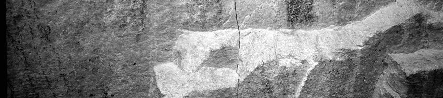
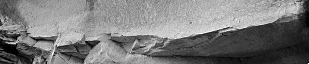
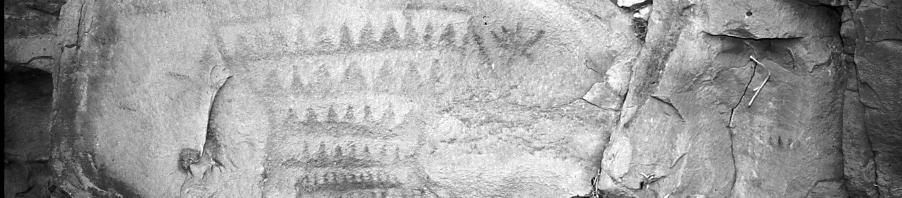
2 Utah Rock Art, Volume 22, 2002 Fremont, and they were interested in discovering what that was. From 1927 to 1931, an extensive inventory of the cultural resources along the Green River and most of its tributaries was conducted under the auspices of the Peabody Museum of Harvard University. Funded by two Boston businessmen, William H Claflin and Raymond Emerson, this expedition broadly covered most of the Fremont areas in Eastern Utah. The expedition resulted in a definition of the Fremont Culture by Noel Morss who participated in the survey of the Fremont River area. Most of the expedition s findings were not reported however, until 1969 by James Gunnerson. In his publication, Gunnerson reexamined the collection and complied the field notes into a comprehensive report on the expedition s findings along with a functional synthesis of the Fremont and their cultural dynamics. The Claflin-Emerson expedition recorded 20 archaeological sites in Range Creek Canyon (Gunnerson 1969: 82-87). Sixteen of these were archaeological sites with masonry storage structures on rock ledges, four were rock shelters with signs of occupation and four were open sites with structural remains. Rock art was noted in association with four masonry storage structures and in one rock shelter. No isolated rock art sites were apparently recorded. The early archaeologists obviously spent most of their time looking for the finest examples of structural sites while ignoring the rock art, unless it was associated with significant cultural remains. In 1936, Leonard Leh, an assistant professor of anthropology from the University of Colorado, recorded nine archaeological sites in Range Creek Canyon. These sites consisted mostly of masonry granaries and ceramic/lithic scatters. Kenneth B. Castleton visited the canyon in May 1975 and noted the presence of 10 rock art sites while observing that several other small ones were bypassed. He stated, All or nearly all the rock art can be assigned to one of the Fremont styles. (Castleton 1978:108). Range Creek is most famous for the elaborate and well preserved figurines that were found by Mr. Pillings, a rancher, in a tributary of Range Creek Canyon (Morss 1954). Smithsonian site numbers were assigned to the 20 sites recorded by the Claflin-Emerson expedition. FINDINGS Archaeological and rock art sites were found to exist from Range Creek s confluence with the Green River to the upper end of the Wilcox Ranch. Thirty-five sites with pictographs and/or petroglyphs were documented. Cultural affiliation ranged from Archaic to Ute. As expected, most of the images were Fremont. Because the ranch was protected behind a series of locked gates for about the past 100 years, the panels have suffered no vandalization, with two exceptions. Several panels with distinctive Fremont anthropomorphic images were discovered that were panted in red (10 R 4/6) and a light to dark yellowish-orange pigment (10 YR 6/6). I discovered several sources for the yellow ochre pigment near the upper end of the ranch. Two were in the back of alcoves (one large and one small) that contained pictographs. Layne Miller and I recently visited a panel in Whitmore Canyon, which is just west of Range Creek, that also contains these same colors and distinctive images, and I discovered a site in the San Rafael Swell area a few weeks later that also has these same colors, and in the same context within the figures. It was anticipated that the rock art in Range Creek would be nearly identical to that found in Nine Mile Canyon, which is just over the ridge at the top of Range Creek. The pass has an elevation of about 6,760 feet. The style of many of the images is the same as those located in Nine Mile Canyon. However, while the rock 104
3 Steven J. Manning, Range Creek Rock Art, The First Year art was culturally similar, the rock art was also different. In addition to containing unique images, there are essentially five differences between rock art in the two canyons. First, there was only one large rock art site in Range Creek Canyon. In Nine Mile Canyon there are many. Nearly all of the panels and individual sites consisted of less than 10 figures. Second, the rock art was not heavily concentrated in some areas, as it is in Nine Mile. The sites seemed to be more evenly distributed throughout the survey area and the canyon. Third, there were a surprisingly high percentage of rock art sites containing pictographs. In Nine Mile Canyon, pictographs are rare - likely less than a few percent. In Range Creek, pictographs constitute neatly half of the rock art sites located to this date. Fourth, there seems to be a greater diversity of styles and types of rock art in Range Creek than in Nine Mile Canyon. This may be due to Range Creek s proximity to the Anasazi Culture area to the south. In addition, the Colorado and Green Rivers could have been a travel corridor bringing the Anasazi northward into Range Creek (see Manning 1992). Fifth, the yellowish-orange pigment that occurs naturally in the canyon was used often in the creation of the pictographs. RECORDED SITES Apparently, only one of the archaeological sites with rock art that were recorded by the Claflin- Emerson expedition was relocated. Out of Castleton s 10 sites, eight were positively identified (sites 1, 2, 3, 4, 5, 7, 8, and 9), and two (sites 6 and 10) were apparently not found. Identification is problematical because Castleton did not photograph the panels, and all that exists is a very cursory description. Photographs of some known and previously unknown panels are shown here. A comprehensive report of these images and a discussion of their significance along with a comparison to other panels is in progress. REFERENCES CITED Castleton, Kenneth B Pictographs and Pictographs of Utah, Volume One: The East and Northeast. Utah Museum of Natural History. Salt Lake City. Gunnerson, James H The Fremont Culture, A study in cultural dynamics on the Northern Anasazi Frontier. Papers of the Peabody Museum of Archaeology and Ethnology, Harvard University, Cambridge, Massachusetts. Leh, Leonard L Prehistoric Pueblo Ruins in Range Creek Canyon, Utah. University of Colorado Studies, 23(2): Boulder. Manning, Steven J Colorado-Green River: Prehistoric Pathway. Canyon Legacy, Number 16: Morss, Noel 1954 Clay figurines of the American Southwest. Papers of the Peabody Museum of Archaeology and Ethnology, Harvard University Papers, 49, number 1. Cambridge, Massachusetts. 105


4 Utah Rock Art, Volume 22,


5 Steven J. Manning, Range Creek Rock Art, The First Year 107


6 Utah Rock Art, Volume 22,


7 Steven J. Manning, Range Creek Rock Art, The First Year 109


8 Utah Rock Art, Volume 22,
9 Steven J. Manning, Range Creek Rock Art, The First Year 111
CHASING GHOSTS. An Analysis of Vandalism and Site Degradation in Range Creek Canyon, Utah. By Jerry D. Spangler, Shannon Arnold and Joel Boomgarden
 CHASING GHOSTS An Analysis of Vandalism and Site Degradation in Range Creek Canyon, Utah By Jerry D. Spangler, Shannon Arnold and Joel Boomgarden Chasing Ghosts: A GIS Analysis and Photographic Comparison
NOTICE OF INTENT MAPS WITH DESCRIPTIONS
 NOTICE OF INTENT MAPS WITH DESCRIPTIONS Location Map(s) to Accompany Notice of Intent The small corner map embedded in the lower left corner of the large map above shows the location of the three national
UTAH S NATIONAL PARK TOUR
 UTAH S NATIONAL PARK TOUR DAY 1 Each client needs to check in any time at the fabulous Aria Hotel located in the heart of Las Vegas. We will meet at 6pm for a one hour orientation explaining the schedule
Monthly Newsletter of URARA, the Utah Rock Art Research Association
 Monthly Newsletter of URARA, the Utah Rock Art Research Association January 2019 May Volume 39 2006 Number Volume 1 26 Number 5 Table of Contents From the Prez... 1 Lake Mountain Field Trip Dec 6-9...
BRYCE CANYON COUNTRY Boulder Mountain Scenic backways itinerary
 BRYCE CANYON COUNTRY Boulder Mountain Scenic backways itinerary Boulder Mountain Area The high plateaus of the Aquarius Plateau (Boulder Mountain), are heavily forested and covered in countless winding
Region 1 Piney Woods
 Region 1 Piney Woods Piney Woods 1. This ecoregion is found in East Texas. 2. Climate: average annual rainfall of 36 to 50 inches is fairly uniformly distributed throughout the year, and humidity and temperatures
2.0 Physical Characteristics
 _ 2.0 Physical Characteristics 2.1 Existing Land Use for the Project The site is comprised of approximately 114 acres bounded by Highway 101 to the north, the existing town of Los Alamos to the east, State
Around Page, Arizona and Southeastern Utah (U17A Part 1)
") Around Page, Arizona and Southeastern Utah (U17A Part 1) For a two-week hiking and sightseeing trip centered on Utah and the Colorado Plateau area, I began with repeat stays in Page, Arizona and Monticello,
Around Page, Arizona and Southeastern Utah (U17A Part 1) For a two-week hiking and sightseeing trip centered on Utah and the Colorado Plateau area, I began with repeat stays in Page, Arizona and Monticello,
Monthly Newsletter of URARA, the Utah Rock Art Research Association
 Monthly Newsletter of URARA, the Utah Rock Art Research Association May 2006 Volume 35 Volume 26 Number 5 Number 5 Table of Contents President s Letter...1 Call for Papers...2 Calendar and Field Trip Schedule...
URARA Symposium 2010, Blanding, Utah Walter Layton, 2010 Symposium Chair
 May 2006 2010 Volume 26 30 Number 5 Monthly newsletter of URARA, the Utah Rock Art Research Association Table of Contents President s Message... 1 URARA Symposium 2010, Blanding, Utah... 1 URARA Call for
Vocabulary Pre and Post Test
 Vocabulary Pre and Post Test Name Directions: Define each of the terms below in your own words. 1. archaeology: 2. petroglyph: 3. mean 4. median 5. conservation Vocabulary Pre and Post Test Answer Key
What Is An Ecoregion?
 Ecoregions of Texas What Is An Ecoregion? Ecoregion a major ecosystem with distinctive geography, characteristic plants and animals, and ecosystems that receives uniform solar radiation and moisture Sometimes
Blanco Creek Ranch Acres, Uvalde County, Texas
 Blanco Creek Ranch 1208.30 Acres, Uvalde County, Texas James King, Agent Office 432 426.2024 Cell 432 386.2821 James@KingLandWater.com Blanco Creek Ranch 1208.30 acres Uvalde County, Texas James King,
Monthly Newsletter of URARA, the Utah Rock Art Research Association
 Monthly Newsletter of URARA, the Utah Rock Art Research Association December 2018 May Volume 38 2006 Number Volume 12 26 Number 5 Table of Contents From the Prez... 1 Kilgore Revises Pit Expansion... 2
SECTION 3 GENERAL DESCRIPTION OF THE RIVER BASIN
 SECTION 3 GENERAL DESCRIPTION OF THE RIVER BASIN SECTION 3 GENERAL DESCRIPTION OF THE RIVER BASIN River basin description. A general description of the river basin or subbasin, as appropriate, in which
Preserving the Paragonah Fremont Site: A Model Public / Private Partnership
 Preserving the Paragonah Fremont Site: A Model Public / Private Partnership Presented by: Dr. James H. McDonald Dean of Humanities & Social Sciences Professor of Anthropology Southern Utah University Overview
Lesson 8 Wilderness: Human Uses, Past and Present
 Lesson 8 Wilderness: Human Uses, Past and Present Objectives: Students will: recognize that cultural resources are part of Wilderness and that these resources provide information about how the area was
Trail Assessment Report
 Trail Assessment Report Trail Options for the Bear Creek Canyon located in Pikes Peak Ranger District, Pike National Forest and on Colorado Springs Utility Lands Due to the presence of a unique species
Brinker Creek Ranch. Colorado - Routt County - Yampa
 Located at the base of the Flattops Range in the Steamboat/Vail corridor, Brinker Creek Ranch consists of 1,451 acres ideally suited for high country grazing and native grass hay production. Traditionally
April 10, Mark Stiles San Juan Public Lands Center Manager 15 Burnett Court Durango, CO Dear Mark,
 Mark Stiles San Juan Public Lands Center Manager 15 Burnett Court Durango, CO 81301 Dear Mark, We are pleased to offer the following comments on the draft San Juan Public Lands Center management plans
Chapter 2: El Dorado County Characteristics and Demographics
 Chapter 2: El Dorado County Characteristics and Demographics 2.1 Geographic Area and Demographics El Dorado County comprises 1,805 square miles with over half of the area in the Eldorado National Forest
AN ARCHAEOLOGICAL ASSESSMENT OF BOERNE CITY PARK, KENDALL COUNTY, TEXAS. Thomas C. Kelly and Thomas R. Hester
 AN ARCHAEOLOGICAL ASSESSMENT OF BOERNE CITY PARK, KENDALL COUNTY, TEXAS Thomas C. Kelly and Thomas R. Hester Center for Archaeological Research The University of Texas at San Antonio Archaeological Survey
NECHAKO CANYON PROTECTED AREA
 NECHAKO CANYON PROTECTED AREA PURPOSE STATEMENT AND ZONING PLAN March 2003 1 Nechako Canyon Protected Area Purpose Statement and Zoning Plan The Nechako Canyon Protected Area (1,246 hectares) is located
Bryce Canyon Country.
 Bryce Canyon Country Backways Itinerary - Grand Staircase, Capitol Reef Region Grand Staircase/Capitol Reef/Henry Mountains Adventure off the beaten path and revel in the beauty of Utah s scenic backways.
Hartsel Springs Ranch 4,637 Acres Park County, Colorado $4,780,000
 Hartsel Springs Ranch 4,637 Acres Park County, Colorado $4,780,000 Presented By: Farm, Ranch & Recreational Real Estate Hartsel Springs Ranch 4,637 Acres Park County, Colorado $4,780,000 Property Description
MODIFYING THE BEARS EARS NATIONAL MONUMENT BY THE PRESIDENT OF THE UNITED STATES OF AMERICA A PROCLAMATION
 This document is scheduled to be published in the Federal Register on 12/08/2017 and available online at https://federalregister.gov/d/2017-26709, and on FDsys.gov MODIFYING THE BEARS EARS NATIONAL MONUMENT
Southwest Quadrant Distinctive Features
 SOUTHWEST QUADRANT Southwest Quadrant Distinctive Features LAND USE The 31.17 square mile Southwest Quadrant includes all the area within the planning area west of I-5 and south of the Sacramento River.
2.0 PARK VISION AND ROLES
 2.0 PARK VISION AND ROLES 2.1 Significance in the Protected Area System Marble Range and Edge Hills provincial parks protect 6.8% of the Pavillion Ranges Ecosection, which is located in the Southern Interior
Steps in the Management Planning Process
 Steps in the Management Planning Process Developing a management plan for Kalamalka Lake Park will follow a multi-stage process. The planning process for this park is currently in the Draft Management
at: Accessed May 4, 2011.
 3.11 SAFETY 3.11.1 Background and Methodology As with other forms of transportation, there is risk associated with aviation activities. This section focuses on risk to those on the ground near airports.
Massanutten Mountain Cluster
 Massanutten Mountain Cluster Signal Knob Catback Mountain Southern Massanutten Mountain Five areas of almost 49,000 acres on the Lee Ranger District compose the Massanutten Mountain Cluster of Mountain
BUCK POINT RANCH. Aspen Associates Realty
 BUCK POINT RANCH Aspen Associates Realty www.aspenassociatesrealty.com 970.544.5800 WELCOME TO Buck Point Ranch is a 960± acre property located in one of the last pristine valleys in close proximity to
Trail Phasing Plan. Note: Trails in the Clear Creek Canyon area (Segments will be finalized in the future to minimize wildlife impacts
 Note: Trails in the Clear Creek Canyon area (Segments 2 5 and a future JCOS connection) will be finalized in the future to minimize wildlife impacts Trail Phasing Plan P Parking 3 Easy Trail Intermediate
Archaeology Internship in the Great Smoky Mountains National Park Summer 2010, Leila Donn
 Archaeology Internship in the Great Smoky Mountains National Park Summer 2010, Leila Donn This past summer I spent three months working as an archaeology intern in the Great Smoky Mountains National Park
Chapter 8: Colorado Plateau State Highway 141, Dove Creek to Naturita
 State Highway 141 Dove Creek to (61 miles) Summary: Highway 141 heads north from US Highway 491 about two miles northwest of the town of Dove Creek. Initially, the highway runs through gently rolling farming
The Salt River by Elly Summer 2016
 The Salt River by Elly Summer 2016 After living in Arizona for many years, I only recently discovered the pleasure of kayaking and tubing. So far, I have been on the river below Saguaro Lake, on Saguaro
General Overview: Acreage:
 General Overview: The Beaver Creek Ranch is located on Beaver Creek in Shell Wyoming, at the base of the western slope of the Big Horn Mountains, one of the west s most spectacular back drops. With an
ARCHAEOLOGY IN TUCSON
 ARCHAEOLOGY IN TUCSON Vol.1, No.4 Newsletter of the Institute for American Research Summer 1987 TRULY THE ORIGINAL TUCSON! In our last AIT newsletter, we presented some of the background about the San
RUBY AND HORSETHIEF CANYONS - COLORADO RIVER
 RUBY AND HORSETHIEF CANYONS - COLORADO RIVER Rating: Class II CFS Range: 1,000-30,000 Length: 1-3 days Gear: Standard paddling gear, bug spray in the summer. Maps: Mack, CO; Ruby Canyon, CO; Bitter Creek
Central Overland Trail Utah & Nevada Driving Guide, First Edition, 2016
 Central Overland Trail Utah & Nevada Driving Guide, First Edition, 2016 Page 51 In the third paragraph, second sentence, change 0.4 miles to 0.1 miles. In the fourth paragraph, second sentence, change
Coyote Gulch, Glen Canyon National Recreation Area, Utah, Spring Break 2009
 Coyote Gulch, Glen Canyon National Recreation Area, Utah, Spring Break 2009 This year, Jen and I decided to revive a tradition begun in our early years together: a yearly Spring Break trip to southern
Greens Peak Ranch Apache County, Arizona
 Greens Peak Ranch Apache County, Arizona Photo [1] View of the deeded land Listed for sale exclusively by: Traegen Knight Headquarters West Ltd. PO BOX 1980 St. Johns, AZ 85936 Phone: (928) 524-3740, Fax:
USDA FOREST SERVICE INTERMOUNTAIN REGION, R4 Manti-La Sal National Forest Phone (435) Natural Resource Specialist GS /7/9
 Natural Resource Specialist GS /7/9") OUTREACH NOTICE USDA FOREST SERVICE INTERMOUNTAIN REGION, R4 Manti-La Sal National Forest Phone (435) 636-3354 Natural Resource Specialist GS-0401-5/7/9 Response requested by December 7, 2016 Position
OUTREACH NOTICE USDA FOREST SERVICE INTERMOUNTAIN REGION, R4 Manti-La Sal National Forest Phone (435) 636-3354 Natural Resource Specialist GS-0401-5/7/9 Response requested by December 7, 2016 Position
Table 1: Black Eagle Communication Site. Latitude 1 Longitude 1 Elev 2 Address T/R/S 3 APN 4 USGS Quadrangle
 County of Riverside Public Safety Enterprise Communication Project Appendix A: Candidate Site Descriptions Overview The site is located on a previously graded and benched plateau within the Black Eagle
Canyons of the Ancients Visitor Center and Museum
 Published on Colorado.com (https://www.colorado.com) One Day Just Isn't Enough: Summer Fun in Cortez, Dolores & Towaoc 3 days More Itineraries Stargazing at stunning Ancestral Puebloan archaeological sites,
Conaway Ranch in Rainbow Canyon Former Golf Course /- Acres with 294 AFA of Water Rights
 Conaway Ranch in Rainbow Canyon Former Golf Course - 244.38 +/- Acres with 294 AFA of Water Rights Rainbow Canyon Rainbow Canyon is named for its spectacular multi-colored rock walls. Meadow Valley Wash,
Subject to sale, withdrawal, or error.
 The Crawford L Bar Ranch is located approximately 40 air miles west of Albuquerque, New Mexico. This ranch truly epitomizes the description of New Mexico being the Land of Enchantment. The topography and
HEATHROW COMMUNITY NOISE FORUM
 HEATHROW COMMUNITY NOISE FORUM 3Villages flight path analysis report January 216 1 Contents 1. Executive summary 2. Introduction 3. Evolution of traffic from 25 to 215 4. Easterly departures 5. Westerly
REEVALUATING THE MIMBRES COLLAPSE AT THE BLACK MOUNTAIN SITE
 REEVALUATING THE MIMBRES COLLAPSE AT THE BLACK MOUNTAIN SITE Kathryn J. Putsavage Southwestern New Mexico is famous for its pottery, the remarkable black-on-white bowls of the Mimbres phase (A.D. 1000-1150)
TAYLOR CANYON RANCH COLORADO - ROUTT COUNTY - STEAMBOAT SPRINGS
 TAYLOR CANYON RANCH COLORADO - ROUTT COUNTY - STEAMBOAT SPRINGS Tucked up against the steep valley shaped by Mt. Pau and rising to the Routt National Forest, Taylor Canyon Ranch is an easily accessible,
United States Department of the Interior National Park Service. Boundary Expansion Listed in National Register January 11, 2017
 NPS Form 10900-a (Rev. 8/2002) OMB No. 10240018 United States Department of the Interior National Park Service Boundary Expansion Listed in National Register January 11, 2017 National Register of Historic
Frizzell Creek Ranch Summerville, OR $1,400, ± Acres
 Frizzell Creek Ranch Summerville, OR $1,400,000 165± Acres 1 Introduction The Frizzell Creek Ranch is a beautiful 165± acre ranch located in northeast Oregon at the base of the Wallowa Whitman National
Presidential Documents
 58081 Presidential Documents Federal Register Vol. 82, No. 235 Friday, December 8, 2017 Title 3 Proclamation 9681 of December 4, 2017 The President Modifying the Bears Ears National Monument By the President
FOURMILE CANYON CREEK PARK Management Plan
 ~J ~l I),.:t '" FOURMILE CANYON CREEK PARK Management Plan LOCATION AND ACCESS Fourmile Canyon Creek Park is located west of Bow Mountain Subdivision. Access to the area is via Pinto Drive in the Bow Mountain
Phoenix Habitat Restoration Projects
 Phoenix Habitat Restoration Projects Spur Cross Ranch Cave Creek (Estergard) Regional Tree and Shade Summit March 9, 2010 Desert Riparian Ecosystems Healthy riparian areas like this once existed along
Treaty Oaks Ranch 323+/- Acres Hood County, Texas $1,776,500
 Bret Polk Mobile: (254) 965-0349 Office: (214) 361-9191 Treaty Oaks Ranch 323+/- Acres Hood County, Texas $1,776,500 LOCATION: The ranch is located in a desirable area 10+/- miles south of Granbury, Texas,
CLIMBING & CAMPING. Las Vegas District NATIONAL CONSERVATION AREA UNIVERSITY OF MINNESOTA LIBRARY. GQVERNMFMT Pi^l'.CiTIOKS
 Generated on 2015-08-13 23:03 GMT / http://hdl.handle.net/2027/umn.31951d00749307j Public Domain, Google-digitized / http://www.hathitrust.org/access_use#pd-google S3, a- RED ROCK CANYON a z NATIONAL CONSERVATION
Subject to sale, withdrawal, or error.
 CANYON DEVELOPMENT PROPERTY RANDALL COUNTY, TEXAS 381.38± ACRES *Drawing For Illustration Only We are pleased to offer the exclusive listing on the. Located in the Texas Panhandle near Canyon and Amarillo,
Oak Creek Ranch Near Sedona, AZ
 Oak Creek Ranch Near Sedona, AZ 1165 E. WILLOW POINT ROAD, CORNVILLE, ARIZONA For nearly half a century David Wick Sr. and his family operated the Oak Creek Ranch School. Thousands of kids have benefited
El Dorado County COMMUNITY WILDFIRE PROTECTION PLAN MOSQUITO FIRE SAFE COUNCIL ACTIVITIES
 El Dorado County COMMUNITY WILDFIRE PROTECTION PLAN MOSQUITO FIRE SAFE COUNCIL ACTIVITIES Prepared for Inclusion in the: EL DORADO COUNTY FIRE SAFE COUNCIL Community Wildfire Protection Plan Diamond Springs,
Notice of Intent to Repatriate Cultural Items: U.S. Department of Agriculture, Forest
 This document is scheduled to be published in the Federal Register on 06/06/2013 and available online at http://federalregister.gov/a/2013-13461, and on FDsys.gov 4312-50 DEPARTMENT OF THE INTERIOR National
Jeff at Bar 10, trikes and planes in background. My trike. Living room, dining room Bar 10 Lodge
 Monday, October 23, 2017 Cobra flight #609, PIC #622, 4 landings Zion Canyon, Bruce Canyon, Escalante, Stevens Arch, San Juan Goosenecks, Bluff Dirt Road I got a great night sleep, and woke up a little
David Prevedel photograph collection.,
 David Prevedel photograph collection., 1900-2010 Overview of the Collection Creator Prevedel, David A. Title David Prevedel photograph collection. Dates 1900-2010 (inclusive) 1900 2010 Quantity 4 Boxes,
Table 1: Avocado Flats Communication Site. Latitude 1 Longitude 1 Elev 2 Address T/R/S 3 APN 4 USGS Quadrangle
 County of Riverside Public Safety Enterprise Communication Project Appendix A: Candidate Site Descriptions Overview The candidate area is located in Northern San Diego County, 0.65 mile south of the border
EPPERSON INDUSTRIAL PARK
 EXCLUSIVE LISTING FUTURE INDUSTRIAL SITE ±680 ACRES SALT LAKE CITY, UTAH 3300 N Subject 40.54 acres 3200 W 550.46 acres 40.17 acres 2100 N 40.09 acres Sold Future State Prison Site ± 325 Acres Haul Road
OWNED LAND ACTIVITIES REPORT February 2012
 OWNED LAND ACTIVITIES REPORT February 2012 BULL RUN MOUNTAINS NATURAL AREA PRESERVE A tremendous number of projects are underway on the Preserve. Currently VOF is working with the Smithsonian Conservation
NEWSLETTER OF THE COLORADO ROCK ART ASSOCIATION (CRAA) A Chapter of the Colorado Archaeological Society.
 A Chapter of the Colorado Archaeological Society.") NEWSLETTER OF THE COLORADO ROCK ART ASSOCIATION (CRAA) A Chapter of the Colorado Archaeological Society http://www.coloradorockart.org November 2017 Volume 8, Issue 10 Inside This Issue Field Trips : Pinon
NEWSLETTER OF THE COLORADO ROCK ART ASSOCIATION (CRAA) A Chapter of the Colorado Archaeological Society http://www.coloradorockart.org November 2017 Volume 8, Issue 10 Inside This Issue Field Trips : Pinon
CHIMNEY ROCK ARCHEOLOGICAL AREA
 CHIMNEY ROCK ARCHEOLOGICAL AREA Phone U.S. Forest Service, Pagosa Springs, Colorado at (303) 264-2268 for tour reservations and information SAN JUAN NATIONAL FOREST PAGOSA RANGER DISTRICT, ARCHULETA COUNTY,
STATE OF WASHINGTON ARCHAEOLOGICAL SITE INVENTORY FORM
 STATE OF WASHINGTON ARCHAEOLOGICAL SITE INVENTORY FORM Smithsonian Number: 45 County: Chelan Date: 6/12/2018 Human Remains? DAHP Case No.: Archaeological Sites are exempt from public disclosure per RCW
A. CONCLUSIONS OF THE FGEIS
 Chapter 11: Traffic and Parking A. CONCLUSIONS OF THE FGEIS The FGEIS found that the Approved Plan will generate a substantial volume of vehicular and pedestrian activity, including an estimated 1,300
CK Ranch Sublette County, Wyoming
 CK Ranch Sublette County, Wyoming 1 Since originally homesteaded in the late me of the finest recreational hunting and e ribbon trout fishing, bordering 5 miles of on request. 2 The CK Ranch is located
Children's Discovery Trail Guide - Lost Creek
 Children's Discovery Trail Guide - Lost Creek Thank you for spending time learning and observing some of the secrets of Red Rock Canyon Conservation Area has to offer. Feel free to talk to a ranger if
13.1 REGIONAL TOURISM ISSUES AND SUMMARY OF FINDINGS
 13 REGIONAL TOURISM T he County of Mariposa s recreation needs and facilities fall within two categories: regional tourism and local recreation. This Element focuses on regional tourism issues related
Frazier Canyon Ranch 3,020 Acres Jeff Davis County, Texas
 Frazier Canyon Ranch 3,020 Acres Jeff Davis County, Texas James King, Agent Office 432 426.2024 Cell 432 386.2821 James@KingLandWater.com Frazier Canyon Ranch 3,020 acres Jeff Davis County, Texas James
Observation of cryosphere
 Observation of cryosphere By Sagar Ratna Bajracharya (email: sagar.bajracharya@icimod.org) Samjwal Ratna Bajracharya Arun Bhakta Shrestha International Centre for Integrated Mountain Development Kathmandu,
Lake Manyara Elephant Research
 Elephant Volume 1 Issue 4 Article 16 12-15-1980 Lake Manyara Elephant Research Rick Weyerhaeuser World Wildlife Fund - U.S. Follow this and additional works at: https://digitalcommons.wayne.edu/elephant
SIMON CANYON AREA OF CRITICAL ENVIRONMENTAL CONCERN (ACEC)
") SIMON CANYON AREA OF CRITICAL ENVIRONMENTAL CONCERN (ACEC) Activities: Facilities: Season / Hours: Description: Hiking, backpacking, fishing, picnicking, watchable wildlife. A graveled parking area, picnic
SIMON CANYON AREA OF CRITICAL ENVIRONMENTAL CONCERN (ACEC) Activities: Facilities: Season / Hours: Description: Hiking, backpacking, fishing, picnicking, watchable wildlife. A graveled parking area, picnic
RECORDS AND LITERATURE SEARCH FOR A PROPOSED PROJECT AT THE CITY OF BLACK RIVER FALLS INDUSTRIAL PARK, JACKSON COUNTY, WISCONSIN.
 RECORDS AND LITERATURE SEARCH FOR A PROPOSED PROJECT AT THE CITY OF BLACK RIVER FALLS INDUSTRIAL PARK, JACKSON COUNTY, WISCONSIN Prepared by Robert J. Barth 1407 Frederic Street Eau Claire, Wisconsin 54701
G R E E N R I V E R - W Y O M I N G - S W E E T W A T E R C O U N T Y
 G R E E N R I V E R - W Y O M I N G - S W E E T W A T E R C O U N T Y Minor Ranch All information contained herein is taken from sources considered reliable, but is not guaranteed by either seller nor
UNITED STATES DEPARTMENT OF THE INTERIOR BUREAU OF RECLAMATION REGION 4 SALT LAKE CITY, UTAH. May 29, 1958
 UNITED STATES DEPARTMENT OF THE INTERIOR BUREAU OF RECLAMATION REGION 4 SALT LAKE CITY, UTAH May 29, 1958 FACT SHEET ON PRIME CONTRACT FOR CONSTRUCTION OF FLAMING GORGE DAM GENERAL INFORMATION Bids will
RANGE EXTENSIONS FOR ERYTHRANTHE ARVENSIS AND E. HALLII (PHRYMACEAE)
") Nesom, G.L. 2016. Range extensions for Erythranthe arvensis and E. hallii (Phrymaceae). Phytoneuron 2016-80: 1 5. Published 12 December 2016. ISSN 2153 733X RANGE EXTENSIONS FOR ERYTHRANTHE ARVENSIS AND
Nesom, G.L. 2016. Range extensions for Erythranthe arvensis and E. hallii (Phrymaceae). Phytoneuron 2016-80: 1 5. Published 12 December 2016. ISSN 2153 733X RANGE EXTENSIONS FOR ERYTHRANTHE ARVENSIS AND
BRYCE CANYON COUNTRY. A twisted tree endures rugged life on the rim of the Paunsaugunt Plateau.
 BRYCE CANYON COUNTRY Grand Staircase - Paunsaugunt Plateau Scenic backways itinerary A twisted tree endures rugged life on the rim of the Paunsaugunt Plateau. Travel to Bryce Canyon Country. Lodging check-in,
Lecture 08, 22 Sep 2003 Role Playing. Conservation Biology ECOL 406R/506R University of Arizona Fall Kevin Bonine
 Lecture 08, 22 Sep 2003 Role Playing Conservation Biology ECOL 406R/506R University of Arizona Fall 2003 Kevin Bonine 1. Role Playing Exercise 2. Exam Wed -group portion outside - ~40 minutes individual,
IMPORTANT PLANT AREA NOMINATION FORM MONTANA. Nominated Site Name: South Pryor Mountains Important Plant Area (IPA)
") IMPORTANT PLANT AREA NOMINATION FORM MONTANA Nominated Site Name: South Pryor Mountains Important Plant Area (IPA) General Location: The South Pryor Mountains IPA is located between the Bighorn River on
IMPORTANT PLANT AREA NOMINATION FORM MONTANA Nominated Site Name: South Pryor Mountains Important Plant Area (IPA) General Location: The South Pryor Mountains IPA is located between the Bighorn River on
An experimental habitat enhancement effort for a sandy river: San Rafael River restoration project
 An experimental habitat enhancement effort for a sandy river: San Rafael River restoration project Samuel Lyster Department of Watershed Sciences, Utah State University Brian G. Laub Department of Watershed
ECONOMIC PROFILE. Tourism
 ECONOMIC PROFILE Tourism Park City & Summit County Utah Prepared by Park City Chamber of Commerce Convention & Visitors Bureau P.O. Box 1630 ~ Park City, UT 84060-1630 800.453.1360 ~ 435.649.6100 ~ fax
NATIONAL ATV / UTV JAMBOREE RIDES
 NATIONAL ATV / UTV JAMBOREE RIDES Note: Rides range from Beginner to Advanced and will last from 2 to 3 hours or an entire day of riding. 1. DESERT RIDE (CLEAR LAKE BIRD REFUGE & LACE CURTAINS/LAVA TUBES)
Settlement Patterns West of Ma ax Na, Belize
 SETTLEMENT PATTERNS WEST OF MA AX NA, BELIZE 1 Settlement Patterns West of Ma ax Na, Belize Minda J. Hernke Faculty Sponsor: Kathryn Reese-Taylor, Department of Sociology/Archaeology ABSTRACT The focus
Welcome to Natural Bridge
 Welcome to Natural Bridge Richard R. Randolph IV www.r4capital.com Www.r4land.com 205-879-5517 Work 205-413-8805 Fax 6 Carla Circle Birmingham, AL 35213 rich@r4capital.com Introduction NATURAL BRIDGE 160
General Summer and Winter Views
 ENVIRONMENTAL INFORMATION REPORT VOLUME 4 APPENDIX 11. 2 General Summer and Winter Views Table of Contents Section APPENDIX 11.2 Page 1 General Views... 1-1 Tansy Lane, Portishead... 1-2 Galingale Way,
APPENDIX J: STAGE 1 ARCHAEOLOGICAL ASSESSMENT
 APPENDIX J: STAGE 1 ARCHAEOLOGICAL ASSESSMENT A.1 Registered Archaeological Sites Within Three Kilometres of the Study Area A total of 112 sites have been registered within three kilometres of the study
Camp Jack Wright PERMANENT ORIENTEERING COURSE (2004)
") Camp Jack Wright PERMANENT ORIENTEERING COURSE (2004) WHAT IS ORIENTEERING? The skill which enables a person to navigate with a map. In the competitive sport, the winner is the person who finishes in the
Camp Jack Wright PERMANENT ORIENTEERING COURSE (2004) WHAT IS ORIENTEERING? The skill which enables a person to navigate with a map. In the competitive sport, the winner is the person who finishes in the
Moon Arches & Canyonlands National Parks (Moon Handbooks) By Bill McRae, Judy Jewell READ ONLINE
 By Bill McRae, Judy Jewell READ ONLINE") Moon Arches & Canyonlands National Parks (Moon Handbooks) By Bill McRae, Judy Jewell READ ONLINE Fodor s Travel Publications; Fodor's Travel Guides; Fodor's Travel; Edition no. 5 Fol Pap/ Moon Arches &
Moon Arches & Canyonlands National Parks (Moon Handbooks) By Bill McRae, Judy Jewell READ ONLINE Fodor s Travel Publications; Fodor's Travel Guides; Fodor's Travel; Edition no. 5 Fol Pap/ Moon Arches &
Restoration of the historic site for public use in Takatsuki City
 Restoration of the historic site for public use in Takatsuki City The Imashirozuka Museum Restoration of the Imashirozuka Burial Mound national historic site for public use Introduction Upon completion
Airport Profile. St. Pete Clearwater International BY THE NUMBERS 818, ,754 $ Enplanements. Passengers. Average Fare. U.S.
 Airport Profile St. Pete Clearwater International St. Pete-Clearwater International Airport (PIE) is located in Pinellas County, Florida about nine miles north of downwn St. Petersburg, seven miles southeast
Lake Wissota Access Locations within the LaFayette Township. By Chad Martin
 Lake Wissota Access Locations within the LaFayette Township By Chad Martin Anson/ Wissota Access Point # 1 Road: 195 th St. Associated Fire Numbers: 13294 Defining Characteristics: Forested from road
II. THE BOULDER CREEK DRAINAGE BASIN
 II. THE BOULDER CREEK DRAINAGE BASIN This section provides an overview of the watersheds and flood hazards associated with Boulder Creek and South Boulder Creek including descriptions of the drainage basins,
Segment 2: La Crescent to Miller s Corner
 goal of the USFWS refuges is to conserve, protect and enhance fish, wildlife and plants and their habitats for the continuing benefit of the American people. Refuge lands are used largely for fishing,
1803 West Hwy 160 Monte Vista, CO (719) TTY (719)
 TTY (719)") USDA Forest Service Rio Grande National Forest http://www.fs.fed.us/r2/riogrande 1803 West Hwy 160 Monte Vista, CO 81144 (719)852-5941 TTY (719)852-6271 USDI Bureau of Land Management San Luis Valley Center
USDA Forest Service Rio Grande National Forest http://www.fs.fed.us/r2/riogrande 1803 West Hwy 160 Monte Vista, CO 81144 (719)852-5941 TTY (719)852-6271 USDI Bureau of Land Management San Luis Valley Center
4. Bronze Age Ballybrowney, County Cork Eamonn Cotter
 4. Bronze Age Ballybrowney, County Cork Eamonn Cotter Illus. 1 Location map of the excavated features at Ballybrowney Lower (Archaeological Consultancy Services Ltd, based on the Ordnance Survey Ireland