LANDS WITH WILDERNESS CHACTERISTICS
|
|
|
- Frank Reeves
- 5 years ago
- Views:
Transcription
1 LANDS WITH WILDERNESS CHACTERISTICS A hiking guide for Ten BLM roadless areas inventoried by Wild Connections Each area description includes a summary of BLM s inventory for wilderness characteristics, a map of the area, and Wild Connections Comment Guidance Refuting and Expanding on BLM s Inventory
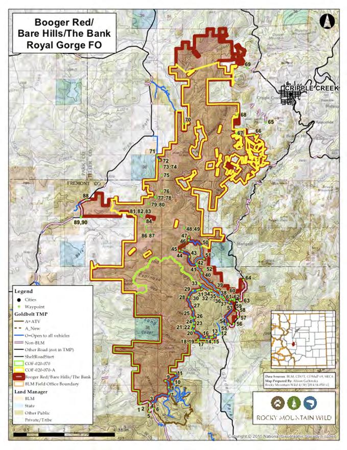
2 Upper Red Canyon (Booger Red Hill) Lands with Wilderness Characteristics Did not meet Wilderness Criteria Summary of BLM s Wilderness Inventory Findings: Sufficient Size? (acres) Naturalness? Outstanding Solitude? Outstanding Primitive and Unconfined Recreation? Supplemental Values? Y N n/a n/a n/a Excerpts from BLM s Wilderness Inventory: N Naturalness - Many man-made features are found within the unit. The accumulative impacts of the features affect the natural character of the unit; therefore, the unit does not possess wilderness characteristics. The man made features include, mining activity, mechanically constructed routes, and historic right-of-ways (ROWs) with linear disturbances. The man made features are highly visible throughout the unit and are a significant impact on the visual lands. Within the unit, vegetation treatment projects are found, with routes to access them and slash piles and stumps visible. N/A Solitude Not evaluated N/A Primitive Unconfined Recreation Not evaluated Comment Guidance Refuting and Expanding on BLM s Inventory Naturalness The area contains a diversity of vegetation types and age classes visually masking the majority of human impacts in the unit. This fact negates BLM s assessment that the unit is not primarily natural in appearance. For example, from the unit s northern border all one sees is an untrammeled, densely vegetated, mixed forest of rolling hills stretching toward the horizon. Another example of the area s naturalness can be found in along Cripple Creek in the unit s northern area where there s a strong presence of biodiversity including globally imperiled plants such as the Degener beardtongue. These examples demonstrate how the area s ecological diversity covers any human-made structure and provides visitors an opportunity to explore a variety of landscapes from grasslands, deciduous forests, cacti, sagebrush, and sunflowers. Solitude Emphasize how much of the area s heavy vegetation and topology screens visitors from unnatural sights and sounds. For example, The dense vegetation served as a buffer, all I heard were sounds of local birds and the wind blowing through the trees. Or, the canyons and rolling rocky hills allowed me to feel as though I was alone is a vast landscape. Primitive Unconfined Recreation The Bank area provides established trails to a vast array of rock climbing routes. Among the reasons for climbing here is the opportunity to do so in a natural setting unmarred by the sights and sounds of modern human development. Outstanding opportunities for hiking and backpacking provide visitors a challenge by requiring the use of a topographic map and compass in order to successfully navigate the canyons and other unique places. The group of primitive campsites in the area allows for overnight camping and the ability to camp, hunt, fish, horseback ride, and viewing of wildlife for multiple days. Supplemental Values - 1. Recreation Complex: The Upper Red LWC unit serves as a cornerstone for quiet-use recreation within the broader complex of recreation opportunities in the immediate vicinity. 2. Ecological Values: The area s 5 Potential Conservation Area s (PCA) are significant for their levels of biodiversity containing globally vulnerable species such as the thinleaf alder, Fendler cloak-fern, and Parry s oatgrass. Additionally Gunnison prairie dogs, Rocky Mountain bighorn sheep, black bear, elk, mule deer, white-tailed deer, mountain lion, and Alberts squirrel.
3
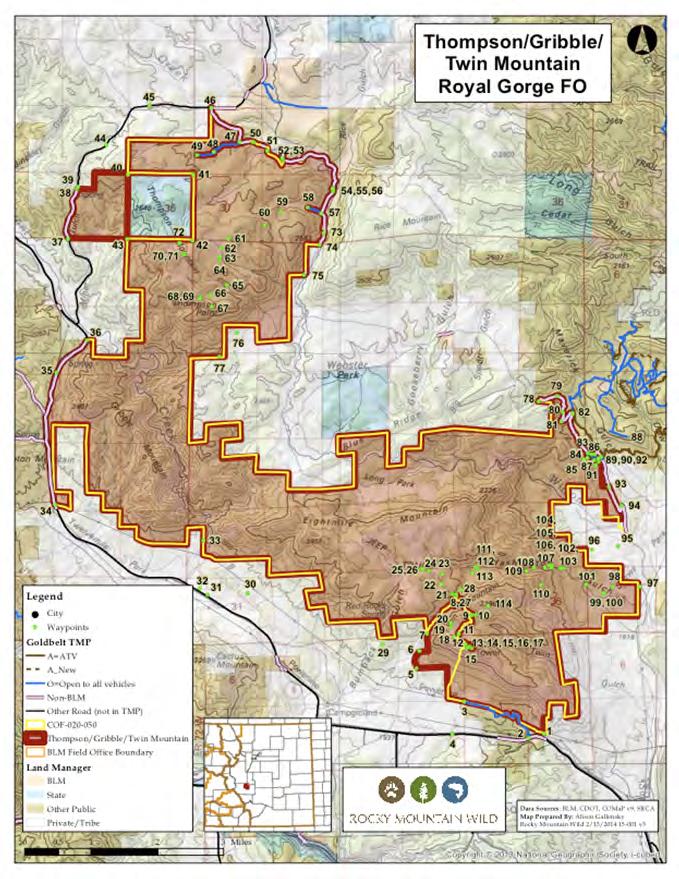
4 Thompson, Gribble, Twin Mountains Lands with Wilderness Characteristics Did not meet Wilderness Criteria Summary of BLM s Wilderness Inventory Findings: Sufficient Size? (acres) Naturalness? Outstanding Solitude? Outstanding Primitive and Unconfined Recreation? Supplemental Values? Y N n/a n/a Y Excerpts from BLM s Wilderness Inventory: N Naturalness The accumulative impacts from man-made features affect the overall naturalness of the area. These include numerous off-highway vehicle routes along Fremont County Road 307 A and Cottonwood Creek, vegetation treatment projects located in the northwestern portion of the unit, and a transmission line located along a ridge denoting the unit s southern boundary. N/A Solitude Not evaluated N/A Primitive Unconfined Recreation Not evaluated Y Supplemental Values This unit is located within elk winter range and mule deer severe winter range as designated by Colorado Parks and Wildlife. Comment Guidance Refuting and Expanding on BLM s Inventory Naturalness Denote how the human impacts to naturalness in the area are minimal and consistent with impacts okay for BLMs standards for naturalness. They are spaced out over 19,200 acres, and go largely unnoticed when traveling the landscape due to topographic and vegetative screening provided by lands within the rest of the proposed LWC. Proactive measures by the BLM to close motorized routes have led to revegetation efforts along routes such as the Wilson Creek Trail and the Thompson Mountain loop trail. Continued efforts will increase the area s overall naturalness. Solitude Emphasize how the area s heavy vegetation and topology screen visitors from unnatural sights and sounds. Highlight how the topographic variety, few entry points, interior trails, and size of the unit afford visitors an opportunity to experience solitude and remoteness. Try to identify specifics such as not seeing any signs of human development. Primitive Unconfined Recreation Discuss the outstanding opportunities for quiet-use recreation such as: hiking, backpacking, camping, hunting, rock climbing, wildlife viewing, photography, horseback riding, etc Highlight specific camping opportunities such as the grasslands near South Twin Mountain, or alongside the Thompson Mountain loop trail, or campsites off the short cherrystems from County Road 69. Supplemental Values - 1. Wildlife: The area is home to black bear, elk, mule deer, pronghorn, mountain lion, Alberts squirrel, Brazil free tailed bat, and the Gunnison s prairie-dog a species of most concern as identified by US Fish and Wildlife. Please describe any sings of these species including tracks, scat, sounds, or sightings. 2. Bird Species: Valued bird species in the unit include bald eagle, Mexican spotted owl, scaled quail, wild turkey, Lewis s woodpecker, geese, and great blue heron. Please note any sightings and/or hearing songs or calls. 3. Visual Resources: Scenic views of nearby and distant mountain ranges are abundant in the area. For example, the Wilson Creek trail affords unique views of Pikes Peak and other mountains toward the northeast. The Thompson Mountain loop offers additional views of Eightmile Mountain and the Sangre de Cristo Mountains. Finally, views from Twin Mountains portray the Arkansas River valley to the south with views of the Wet Mountains the Sangre de Cristo Mountains.
5
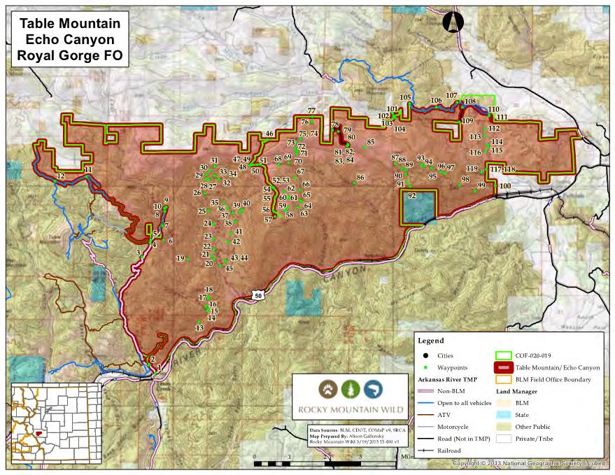
6 Table Mountain/Echo Canyon Lands with Wilderness Characteristics Did not meet Wilderness Criteria Summary of BLM s Wilderness Inventory Findings: Sufficient Size? (acres) Naturalness? Outstanding Solitude? Outstanding Primitive and Unconfined Recreation? Supplemental Values? Y N n/a n/a Y Excerpts from BLM s Wilderness Inventory: N Naturalness The accumulative impacts of vegetation treatment projects significantly impact the naturalness of the unit. Additionally, the impacts of mining are also visible throughout the area and have a visual impact on the landscape. Overall, the inventory concluded the unit does not possess wilderness characteristics due to excessive imprints of man. N/A Solitude Not evaluated N/A Primitive Unconfined Recreation Not evaluated Y Supplemental Values The Colorado Natural Heritage Program (CNHP) has identified 675 acres to be managed as a Research Natural Area similar to a Wilderness Study Area and has identified the west portion of the unit to contain a high to very high rate of biodiversity. There are historic cabins and a homestead located within the unit, alongside habitat for bighorn sheep, elk winter range, and bighorn sheep production area. Comment Guidance Refuting and Expanding on BLM s Inventory Naturalness Highlight that motorized access is limited to boundary roads, and a couple short cherrystems along the unit s western portion. It s also apparent that other routes show a lack of motorized and overall regular use, with the forces of nature reclaiming many of the former routes. Although there are human impacts in the area, they are not visible unless in the immediate vicinity and the majority are minor and consistent with BLM Manual 6310 thus not affecting the natural integrity of the unit. Additionally, the land and routes have had over 20 years of rewilding with little to no use. Solitude Emphasize how the few entry points, lack of trails (motorized and non-motorized_ and observed lack of overall use provide ample opportunity for solitude. For example, East Gulch is a great place to find seclusion and can be accessed easily from cherrystem road BLM Primitive Unconfined Recreation Discuss how the unit s near 31,600 acres of contiguous unroaded lands provide for a variety of primitive and unconfined recreational opportunities such as hiking, backpacking, camping, rock climbing, hunting, wildlife viewing, bird watching, horseback riding, and photography. For example, the top of the Table Mountain plateau provide excellent opportunities for sightseeing and photography. Supplemental Values - 1. The unit is part of a greater connectivity corridor aligning with BLM s Arkansas Canyonlands Area of Environmental Concern recognized for outstanding recreation, scenic views, critical and valued species, and the High Mesa Grassland Research Natural Area. 2. The Colorado National Heritage Program recognizes two very high biodiversity areas in the unit as Potential Conservation Areas. The presence of many globally imperiled and vulnerable plant species including the Arkansas Canyon Sticklead, Degener beardtongue, Fendler cloak-fern, and jeweled blazingstar.
7
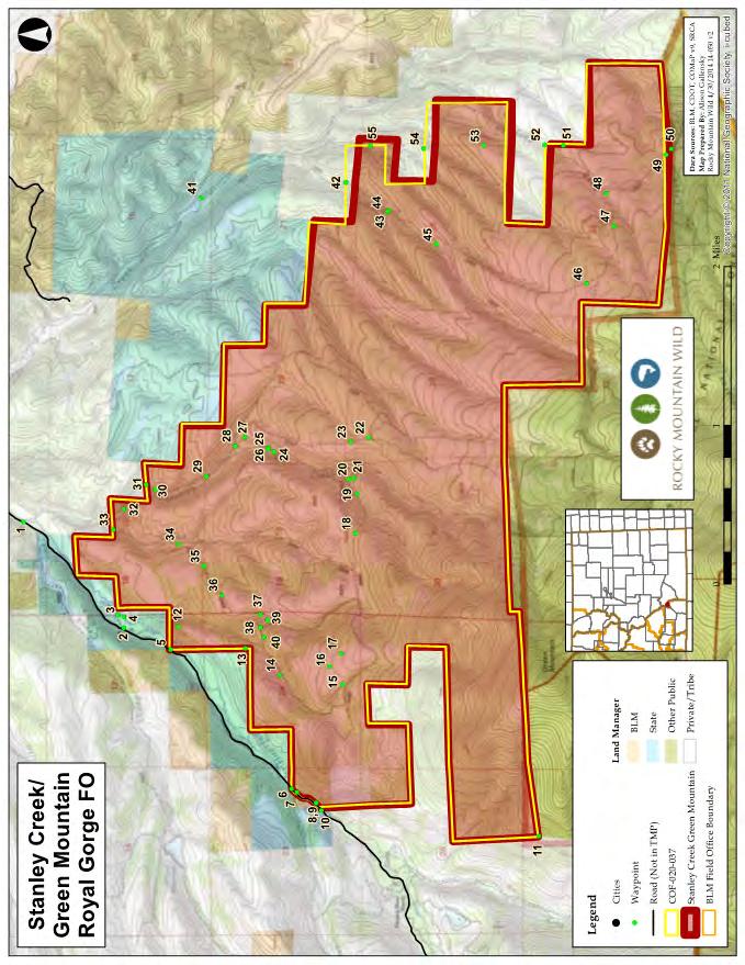
8 Stanley Creek, Green Mountain Lands with Wilderness Characteristics Did not meet Wilderness Criteria Summary of BLM s Wilderness Inventory Findings: Sufficient Size? (acres) Naturalness? Outstanding Solitude? Outstanding Primitive and Unconfined Recreation? Supplemental Values? Y N N/A N/A Y Excerpts from BLM s Wilderness Inventory: N Naturalness Man-made features include a two-track motorized route that is no longer open to the public. This route is currently open for administrative use only and due to a lack of use, the route is fading, yet still noticeable. Range use in prevalent within the unit, including spring developments, corals, stock tanks, and fence lines. Although range use is visible it does not affect the overall naturalness of the area. Other man-made features include old cabins and a homestead site. The cabins are historic, add supplemental value to the unit and therefore do not affect the unit s naturalness. N/A Solitude Not evaluated N/A Primitive Unconfined Recreation Not evaluated Y Supplemental Values This unit contains a historic homestead site along the Stanley Creek drainage. The unit also contains elk summer range, production area, and severe winter range alongside mule deer winter range. Additionally, the unit is located within the Sangres Lynx Analysis Unit and contains primary and secondary lynx habitat. Comment Guidance Refuting and Expanding on BLM s Inventory Naturalness Highlight how the area is primarily affected by the forces of nature with human impacts being minor and/or occurring a considerably long time ago. It s important to note that the few minor human impacts spread throughout the area do not hinder the area s overall naturalness and how public access is limited to two defined access points, neither of which permits motorized use. Lastly, discuss how many of the other trails and former motorized routes show an apparent lack of regular use and thus have been reclaimed by the forces of nature.. Comments should also reference the diversity of ecosystems and vegetation types found throughout the area. For example, the many gulches and creeks offer habitat for rich riparian life, and the groves of high-elevation mixed forests and montane grasslands provide for an assortment of flora and fauna. Solitude Emphasize how the area s heavy vegetation and topology screen visitors from unnatural sights and sounds. Highlight how the topographic variety, few entry points, interior trails, and size of the unit afford visitors an opportunity to experience solitude and remoteness. Try to identify specifics such as not seeing any signs of human development. Primitive Unconfined Recreation Discuss the lack of visitation and outstanding opportunities for respite and remoteness while hiking, biking, backpacking, camping, hunting, fishing, wildlife viewing, bird watching, horseback riding, snowshoeing, and photography. Supplemental Values -. The proposed LWC is contiguous with the greater Sangre de Cristo Wilderness and San Isabel National Forest, a vast corridor of species connectivity. The Stanley Creek, Green Mountain proposed LWC unit extends this connectivity core 5,500 acres north to lower elevation foothills which is critical habitat for many species and provides connectivity to the Huerfano State Wildlife area and Manzanares Creek State Trust Land block.
9
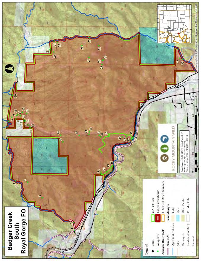
10 South Badger Creek Lands with Wilderness Characteristics Meets all Wilderness Criteria Summary of BLM s Wilderness Inventory Findings: Sufficient Size? Naturalness? Outstanding Solitude? Outstanding Primitive and Unconfined Recreation? Supplemental Values? Y Y Y Y Y Excerpts from BLM s Wilderness Inventory: Y Solitude Outstanding opportunities for solitude exist throughout the unit. Topographic relief and thick vegetation allows for separation from man- made disturbances. A portion of the unit where the majority of use occurs is along Badger Creek. Although many public land visitors frequent Badger Creek, the abundant riparian vegetation along the creek provides excellent visual and audible screening, allowing for solitude to exist. Y Primitive Unconfined Recreation The unit provides outstanding opportunities for primitive recreation due to the unique topography, undeveloped facilities, and non-motorized recreation possibilities. The unit provides excellent recreation possibilities, such as hiking, fishing, sightseeing, hunting, wildlife viewing, and photography. Excellent sightseeing opportunities are available in the higher elevations with vistas of the Arkansas River Canyon, Sangre de Christo Mountains, and the Collegiate Peak Mountain. Y Supplemental Value 1. Wildlife: The unit contains mule deer and elk severe winter range as mapped by Colorado Parks and Wildlife. 2. Ecological: The east central part of the unit has been identified by the Colorado Natural Heritage Program as a potential conservation area (PCA). The unnamed tributary to Badger Creek at Howard site has a very high biodiversity significance ranking. BLMs report highlights the significance of the natural riparian community such as the presence of the globally imperiled pale blue-eyed grass. 3. Geological: Sand stone hogbacks are found in the northeastern portion of the unit. 4. Historical: An historic wagon trail follows Badger Creek and Little Badger Creek along with archeological sites as cited by the BLM. Comment Guidance Affirming and Expanding on BLM s Inventory Solitude Highlight the importance of seeing infrequent, unnoticeable, or non-existent encounters with humans. For example I saw only 1 person while on a 4 hr. hike, If other people were in the area it went unnoticed due to the terrain and vegetation/ I heard only the sound of birds, I saw no footprints, etc. Primitive Unconfined Recreation Badger Creek is one of the few primarily spring-fed streams in this part of the state, providing excellent opportunities for backcountry trout fishing! Comments should emphasize the ability for self-challenge within an area. For example, route-finding through the canyon means getting to enjoy the challenge of using a topographic map to successfully navigate special places, etc. Supplemental Values - 1. Wildlife habitat: In addition to mule deer and elk severe winter range, the unit contains habitat and range values for a multitude of wildlife species, including the Rocky Mountain bighorn sheep, black bear, elk, mule deer, pronghorn, mountain lion, and the Brazilian free-tailed bat. 2. Regional Access & Resources : Spring-fed streams on accessible public lands are regionally rare as more often than not they are located on private lands.
11
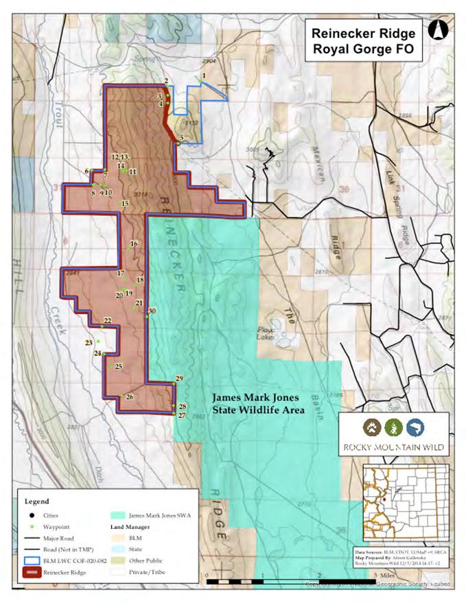
12 Reinecker Ridge Lands with Wilderness Characteristics Did not meet Wilderness Criteria Summary of BLM s Wilderness Inventory Findings: Sufficient Size? (acres) Naturalness? Outstanding Solitude? Outstanding Primitive and Unconfined Recreation? Supplemental Values? N N/A N/A N/A N/A Excerpts from BLM s Wilderness Inventory: N Sufficient Size The unit is smaller than 5,000 acres and is bounded on the north by wilderness inventory road Park County Bar D. The remaining edges are defined by property lines other then BLM management. N/A Naturalness Not evaluated N/A Solitude Not evaluated N/A Primitive Unconfined Recreation Not evaluated N/A Supplemental Values Not evaluated Comment Guidance Refuting and Expanding on BLM s Inventory Sufficient Size While the unit is smaller than 5,000 acres it still qualifies as lands with wilderness characteristics due to the area being contiguous with the 17,429 acre James Mark Jones State Wildlife Area. The State Wildlife Area is managed to retain in natural values, backcountry recreation experiences and wildlife habitat. Additionally it resides along the unit s eastern border and actually contains the majority of Reinecker Ridge itself. Naturalness Comments should highlight how the area is primarily affected by the forces of nature, with human impacts mostly unnoticeable within the unit. The few minor human impacts found within the unit do not affect the natural integrity or the apparent naturalness of the overall unit. Solitude Emphasize the how the few entry points, plethora of trails, and observed lack of overall use provide ample opportunities for solitude. Comments could reflect on how the many groves of mixed forests found throughout provide excellent screening from unnatural sights and sounds. Primitive Unconfined Recreation Comments should reflect the outstanding opportunities for hiking, biking, backpacking, camping, hunting, snowshoeing, wildlife viewing, bird watching, horseback riding, and photography. Supplemental Values The area is part of a greater ecological connectivity core and has been found to contain significant to very high levels of biodiversity by the Colorado Natural Heritage Program (CNHP). Additionally, it is within CNHP s biodiversity assessment of a greater South Park mega site containing globally rare, unique rich fen wetlands as well as globally and state rare plants. The area contains plants that have adapted to the rich fens, including the globally vulnerable Colorado Tansy-aster, rare plant communities including the globally imperiled wetland community Festuca arizonica- Muhlenbergia filiculmis, the world s largest grassland occurrence at 1.3 million acres, and the globally vulnerable Mountain Plover and its breeding ground. The Mountain Plover, a bird found to have high occurrence in the area, is listed as Colorado Department of Wildlife species of concern, a species of most concern by the US Wildlife Conservation and Restoration Program s Comprehensive Wildlife Conservation Strategy, Colorado BLM sensitive, and a Partnership in Flight Priority Bird.
13
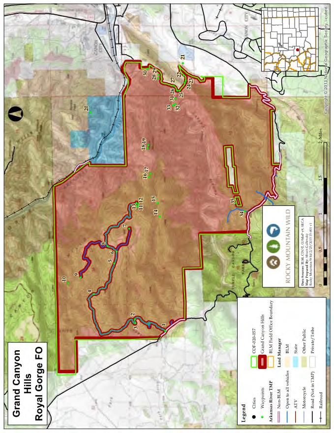
14 Grand Canyon Hills Lands with Wilderness Characteristics Did not meet Wilderness Criteria Summary of BLM s Wilderness Inventory Findings: Sufficient Size? (acres) Naturalness? Outstanding Solitude? Outstanding Primitive and Unconfined Recreation? Supplemental Values? Y N Y Y N Excerpts from BLM s Wilderness Inventory: N Naturalness Most of the land on the east side of the unit, near Ecology Par,k shows substantial evidence of human modification. There are many constructed and maintained motorized routes in this part of the unit. Also, the Deweese water gap diversion dam located in route J in Grape Creek Canyon is a visual impact on the landscape impacting the average observer s experience. Other human activities include remnants from a historic railroad circa 1800 s. Additionally, although mining disturbance is isolated it s still noticeable on parts of the unit. Y Solitude High topographic relief, rugged terrain, thick vegetation, and vast expanses of lands allows remote portions within the unit to have outstanding opportunities for solitude. Further, portions along Grape Creek, a popular hiking and fishing location, are difficult to access thus creating outstanding opportunities for solitude. Y Primitive Unconfined Recreation There are no developed facilities within the unit, and all camping is primitive. Excellent recreational opportunities include: hiking, backpacking, fishing, rafting, sightseeing, hunting, and wildlife viewing - Recreational opportunities becoming outstanding due to the challenging topography and vast opportunities. Y Supplemental Values The Grape Creek riparian area is designated as an Area of Critical Environmental Concern by the RGFO s 1995 RMP. The Water Gap site is a Colorado Natural Heritage Program potential conservation area due to a very high significance of biodiversity. The Royal Gorge, Grand Canyon Hills site is another CNHP site also have a very high rate of biodiversity. There are remnants from a historic railroad through Grape Creek as well as a historic water line through the Royal Gorge. Lastly, the unit contains bighorn sheep and mule deer sever winter range as mapped by CPW. Comment Guidance Refuting and Expanding on BLM s Inventory Naturalness Many routes show a lack of motorized use and an overall apparent lack of regular use. The LWC offers many vegetation types due to topographic variety and diverse ecosystems. Further, Grape Creek is a perennial stream, relatively rare for this area, offering rich riparian life. Although BLM cited minor impacts from thinning in 2003, they also stated that this impact is largely unnoticeable and does not affect the overall natural character. BLM also cites other impacts such as railroad remnants and a historic water line but acknowledges these as adding supplemental value to the unit. Solitude Topographic variety combined with few entry points and interior trials provide great opportunities for those seeking solitude. Emphasize the great opportunities for primitive camping at several dispersed campsites throughout the unit s interior. Primitive Unconfined Recreation Discuss the outstanding opportunities for quiet-use recreation such as: hiking, backpacking, camping, hunting, wildlife viewing, photography, horseback riding, etc Supplemental Values Many critical and valued bird species (great blue heron, osprey, Mexican spotted owl, bald eagle, and American Falcon) have been identified in the area alongside high habitat and range values for many wildlife species such as bighorn sheep, black bear, mile deer, white tailed deer, pronghorn, mountain lion, Brazilian free tailed bat, and Gunnison s prairie-dog.
15
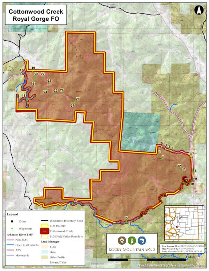
16 Crampton Mountain Lands with Wilderness Characteristics Did not meet Wilderness Criteria Summary of BLM s Wilderness Inventory Findings: Sufficient Size? (acres) Naturalness? Outstanding Solitude? Outstanding Primitive and Unconfined Recreation? Supplemental Values? Y N n/a n/a Y Excerpts from BLM s Wilderness Inventory: N Naturalness The impact of man-made features found within the unit affect the natural character of the unit. The mad-made features include numerous routes that receive off-highway vehicle use. The majority of use occurs along Fremont County Road 307 A and Cottonwood Creek. The routes appear to have been originally constructed by mechanical means. The constructed nature of the routes is a visual impact on the landscape. N/A Solitude Not evaluated N/A Primitive Unconfined Recreation Not evaluated Y Supplemental Values This unit is located within elk winter range and mule deer severe winter range as designated by Colorado Parks and Wildlife. Comment Guidance Refuting and Expanding on BLM s Inventory Naturalness Comment how many of the human impacts referenced by the BLM are not actually in the unit. All defined roads in the area (Fremont County Road 307A, Fremont County Road 21, transmission access route, BLM TMP roads) are quite short and removed from the proposed LWC via cherrystems. Although the transmission line access route has been excluded it would be erroneous to assume that this hinders the natural integrity and apparent naturalness. After all this is located outside the proposed unit. Discuss how observed OHV routes are minimal and barely noticeable. Further, these routes were not created, and are not maintained by mechanical means, nor do they appear regular or continuous. These routes are not in the Arkansas River TMP and have no designation on the ground. These routes should be closed with proper signage. Solitude Emphasize how the area s heavy vegetation and topology screen visitors from unnatural sights and sounds. Highlight how the topographic variety, few entry points, interior trails, and size of the unit afford visitors an opportunity to experience solitude and remoteness. Try to identify specifics such as not seeing any signs of human development. Primitive Unconfined Recreation Discuss the outstanding opportunities for quiet-use recreation such as: hiking, backpacking, camping, hunting, rock climbing, wildlife viewing, photography, horseback riding, etc Supplemental Values - 1. Wildlife: The area is home to black bear, elk, mule deer, pronghorn, mountain lion, Alberts squirrel, Brazil free tailed bat, and the Gunnison s prairie-dog a species of most concern as identified by US Fish and Wildlife. Please describe any sings of these species including tracks, scat, sounds, or sightings. 2. Bird Species: Valued bird species in the unit include bald eagle, Mexican spotted owl, scaled quail, wild turkey, Lewis s woodpecker, geese, and great blue heron. Please note any sightings and/or hearing songs or calls. Visual Resources: Scenic views are abundant throughout. There are exceptional views of the surrounding mountains from many of the highpoints within the unit including Eightmile Mountain, Twin Mountains, Copper Mountain and beyond.
17
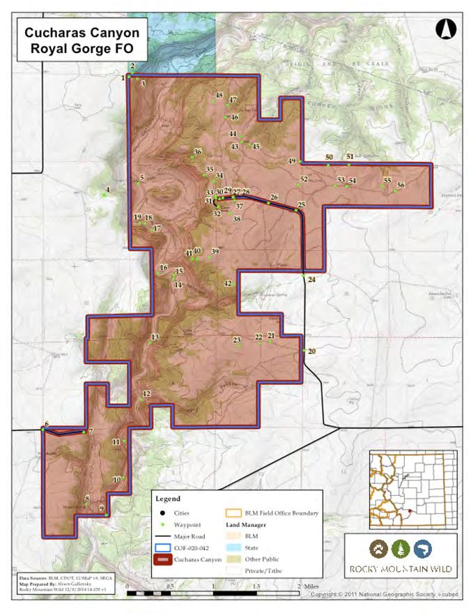
18 Chucharas Canyon Lands with Wilderness Characteristics Did not meet Wilderness Criteria Summary of BLM s Wilderness Inventory Findings: Sufficient Size? (acres) Naturalness? Outstanding Solitude? Outstanding Primitive and Unconfined Recreation? Supplemental Values? Y N N/A N/A Y Excerpts from BLM s Wilderness Inventory: Y Sufficient Size The unit is 6,061 acres. Y Naturalness The Kenner Ranch homestead located at the end of Kenner Ranch Road has many recent human made features. Kenner Rach consists of historic buildings, fences, and a corral. Near the site, other man made features are present including stock tanks, developed springs, and multiple routes used to access tanks and fence lines. Additional man-made features affecting the unit s natural character include two cisterns recently filled with cement. The unit may eventually have wilderness characteristics if man-made features are removed and routes have possible decades to revert to natural appearance. The unit does not possess wilderness characteristics due to the present imprints of man. Y Solitude Not evaluated Y Primitive Unconfined Recreation Not evaluated Y Supplemental Values The unit is within the Colorado Natural Heritage Program s Potential Conservation Area for having high levels of biodiversity. In 2003 a successful transplant of Bighorn sheep occurred in the unit. Further, views from the Cucharas Canyon rim are superb, which is a rarity in the plains; there are historic homestead buildings alongside a coral, and lastly there is evidence of inhabitation by indigenous peoples. Comment Guidance Refuting and Expanding on BLM s Inventory Solitude If you have visited this unit, describe infrequent, unnoticeable, or non-existent encounters with humans. For example, I saw only 1 person while on a 4 hour hike, or If other people were in the area it went unnoticed due to the terrain and vegetation I heard on the sound of birds, or I saw no footprints. Etc. Primitive Unconfined Recreation Comments should re-enforce BLMs findings and, when possible, expand on opportunities noting for example bird watching, wildflower identification and wildlife identification (via visible tracks), fishing for tout in Badger Creek. Supplemental Values The Cucharas Canyon proposed LWC is the only federally managed roadless area in the eastern Colorado plains that meets the criteria of Lands with Wilderness Characteristics. Additionally, BLM recognizes Cucharas Canyon as an Area of Critical Environmental Concern (ACEC) primarily for its cultural resources that reflect the importance of the area to Native Americans, settles, and ranchers. Nearly the entirety of this proposed LWC has high biodiversity significance as identified by the Colorado Natural Heritage Program (CNHP) and is encompassed within a greater 209,000 acre Potential Conservation Area. The area contains rare plant and animal species such as the state critically imperiled Elton s lip fern, Simius roadside skipper vulnerable in Colorado, swift fox globally vulnerable, and a fair occurrence of the black-tailed prairie dog. Additionally, the area is also noteworthy for its disparate geological features. The majority of Cucharas Canyon is from the Jurassic Period, with the northern part showing evidence of older rocks dating back to the Permian- Pennsylvanian Age.
19
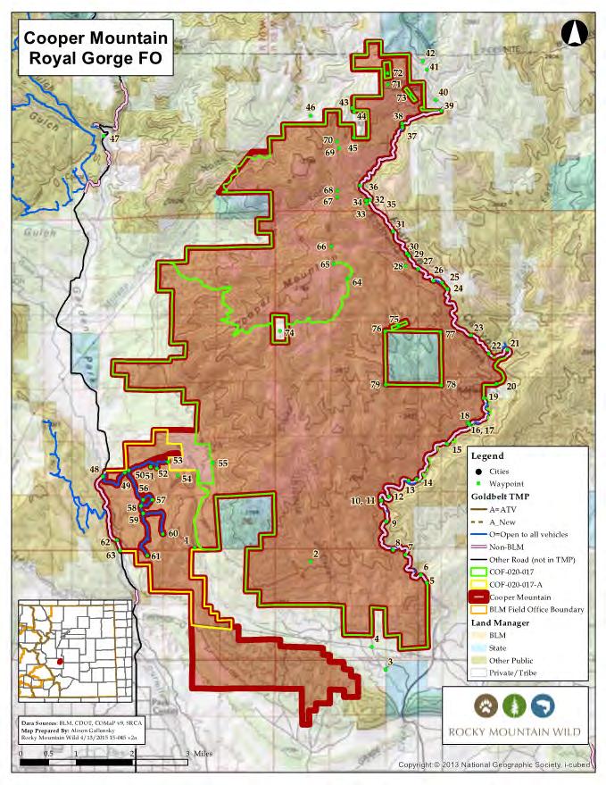
20 Cooper Mountain Lands with Wilderness Characteristics Meets all Wilderness Criteria Summary of BLM s Wilderness Inventory Findings: Sufficient Size? Naturalness? Outstanding Solitude? Outstanding Primitive and Unconfined Recreation? Supplemental Values? Y Y Y Y Y Excerpts from BLM s Wilderness Inventory: Y Naturalness It is apparent that the unit has had imprints of man within the unit, but compared to the overall size, lack of public motorized use, and natural processes beginning to reclaim certain features the unit is considered to have apparent naturalness. Y Solitude The unit contains a vast amount of land with high topographic relief. Thick vegetation provides excellent screening, especially in the drainages where riparian vegetation offers audible and visual screening. Opportunities for solitude are guaranteed in the majority of the unit. Y Primitive Unconfined Recreation The unit provides outstanding opportunities for primitive recreation due to the vast amount of land, undeveloped facilities, and non-motorized recreation possibilities. Challenging overland travel and multiple trails within the unit offers an optimal primitive recreation experience. Y Supplemental Value This includes: historic homestead with cabins, scenic views of the Front Range, 3 potential Colorado Natural Heritage Program conservation areas: Felch Creek (very high biodiversity significance), Blue Mtn. to Phantom Canyon (high biodiversity significane), and Phantom Canyon of Eight mile Creek (very high biodiversity significance). Additionally, the unit contains Mexican spotted owl critical habitat as well as mile deer winter range and elk sever winter range. Comment Guidance Affirming and Expanding on BLM s Inventory Solitude Highlight the importance of seeing infrequent, unnoticeable, or non-existent encounters with humans. For example I saw only 1 person while on a 4 hr. hike, If other people were in the area it went unnoticed due to the terrain and vegetation/ I heard only the sound of birds, I saw no footprints, etc. Primitive Unconfined Recreation There are outstanding opportunities for hiking, sightseeing, hunting, wildlife viewing, snowshoeing, and photography. Additionally, there are a variety of backpacking, camping, MTN. bike ridings, or horseback riding option on designated trails. Supplemental Values Comments should focus on continued protection for the two BLM designated Areas of Environmental Concern (ACESs) that are partially contained within this unit. Garden Park Fossil Area is renown nationally as a premier paleontological site and is the location of first discovery of several dinosaur species. Phantom Canyon is the second ACEC and is recognized for many of the historic sites along the former railroad in this rugged and scenic canyon. The area also contains habitat for several species of particular interest. The swift fox is listed as a threatened species by Colorado Parks and Wildlife as well as Colorado BLM sensitive. The black-tailed prairie-dog is a species of concern for CPW, Colorado BLM sensitive, and a Comprehensive Wildlife Conservation Strategy (CWCS) Species of Most Concern. Preble s meadow jumping mouse is a CPW threatened species and a CWCS Species of Most Concern. The Brazilian free tailed bat is a Colorado state ranked critically imperiled species and the black-footed ferret is listed as an endangered species.
21
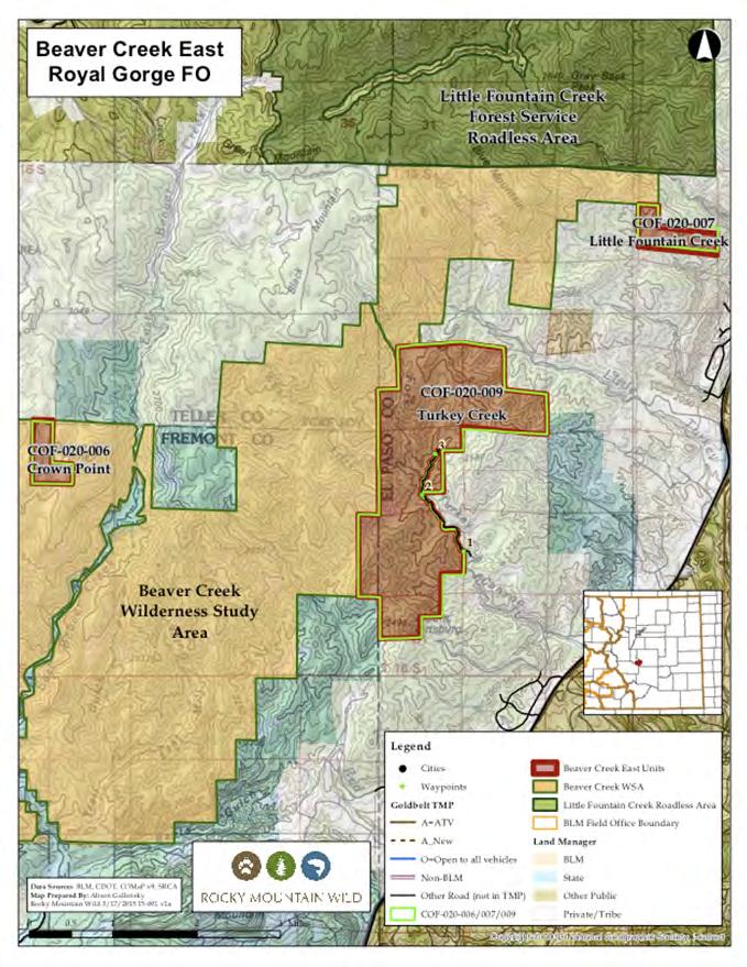
22 Beaver Creek Lands with Wilderness Characteristics Did not meet Wilderness Criteria Summary of BLM s Wilderness Inventory Findings: Sufficient Size? (acres) Naturalness? Outstanding Solitude? Outstanding Primitive and Unconfined Recreation? Supplemental Values? Y Y Y Y Y Excerpts from BLM s Wilderness Inventory: Y Naturalness Existing human impacts found within the unit have a relatively small impact on the overall naturalness of the area. Although range activity was found within the unit, it was found to be insignificant. A 2002 wilderness inventory conducted in the Turkey Creek area concluded the imprints of man - including an access road, historic mink ranch, and logging activity disqualified the area from wilderness consideration. However a 2013 inventory concluded the imprints of man such as cabins, mill site, and homesteads add supplemental value and that enough time has occurred allowing the unit to convert back to wilderness character. Y Solitude Opportunities for solitude become outstanding due to the difficulty of motor vehicle access and/or challenging travel due to high topographic relief. Numerous side drainages, thick timber, and rugged canyons contribute to opportunities to seek solitude. Sweeping vistas of the Front Range, Wet Mountains, and Great Plains allow for a feeling of vastness, thus ensuring the feeling of solitude. Y Primitive Unconfined Recreation Outstanding opportunities for primitive recreation are abound due to the unique topography, undeveloped facilities, and non-motorized recreation possibilities. For example, Badger Creek offers recreational activities such as hiking, hunting, and fishing. The area s streambeds are sandy or scoured bedrock making them pleasant to walk in and thus allowing visitors to see the many unique ecologic features. Y Supplemental Values This area is located within the RGFO s Beaver Creek Area of Critical Environmental Concern (ACEC), is a Colorado National Heritage Program Potential Conservation Area for biodiversity interest, has historic homestead timbers and foundations, a historic pack trail/mail route, habitat for peregrine falcon nesting, Mexican spotted owl critical habitat, and provides habitat for elk severe winter ranged as mapped by Colorado Parks and Wildlife. Comment Guidance Refuting and Expanding on BLM s Inventory Naturalness Comments should reflect that there is no motorized public access to any of the unit, with public access limited to traversing the backcountry via the contiguous Beaver Creek WSA. The BLM found no significant human impacts within this unit, and the few impacts being actively reclaimed by vegetation and largely unnoticeable. Further, many of the remaining impacts are now considered historical, adding supplemental value as noted by the BLM.. Solitude There are vast opportunities for solitude given the topographic variety, dense vegetation, few public entry points and lack of trails (motorized and non-motorized). The rugged hills, canyon, and cliffs provide screening from unnatural sights and sounds. Additionally, the many gulches and drainages provide outstanding opportunities for those seeking solitude. Supplemental Values The unit provides a vast corridor for species of the mountains and foothills as well as providing a critical linkage for the flora and fauna of the diverse western Great Plains to the east and the Upper Sonoran zone to the south. Habitat for significant bird species include, Mexican spotted owl, Peregrine Falcon, and bald eagle. BLM attributes supplemental value to the two waterfalls found within the Turkey Creek area as well as to the various historical structures, buildings, and sites that all enhance the area s wilderness characteristics.
23
Lands with Wilderness Characteristics: Reinecker Ridge
 Lands with Wilderness Characteristics: Reinecker Ridge Reinecker Ridge, Royal Gorge Field Office Photo: John Sztukowski The intent of this report is to present objective data to illustrate that the area
Lands with Wilderness Characteristics: Stanley Creek, Green Mountain
 Lands with Wilderness Characteristics: Stanley Creek, Green Mountain Green Mountain, Royal Gorge Field Office Photo: Jaimie Reiss The intent of this report is to present objective data to illustrate that
Lands with Wilderness Characteristics: Chipeta and Pahlone Foothills
 Lands with Wilderness Characteristics: Chipeta and Pahlone Foothills Ouray, Chipeta, and Pahlone Peaks over interior unit, Royal Gorge Field Office Photo: John Sztukowski The intent of this report is to
Lands with Wilderness Characteristics: Thirtyone Mile Mountain
 Lands with Wilderness Characteristics: Thirtyone Mile Mountain Thirtyone Mile Mountain, Royal Gorge Field Office Photo: John Sztukowski The intent of this report is to present objective data to illustrate
Lands with Wilderness Characteristics: Browns Canyon South
 Lands with Wilderness Characteristics: Browns Canyon South Browns Canyon South, Royal Gorge Field Office Photo: John Sztukowski The intent of this report is to present objective data to illustrate that
2.0 PARK VISION AND ROLES
 2.0 PARK VISION AND ROLES 2.1 Significance in the Protected Area System Marble Range and Edge Hills provincial parks protect 6.8% of the Pavillion Ranges Ecosection, which is located in the Southern Interior
Connie Rudd Superintendent, Black Canyon of the Gunnison National Park
 National Park Service U.S. Department of the Interior Black Canyon of the Gunnison National Park and Curecanti National Recreation Area Information Brochure #1 Wilderness and Backcountry Management Plan
WORKSHEET 1 Wilderness Qualities or Attributes Evaluating the Effects of Project Activities on Wilderness Attributes
 WORKSHEET 1 Wilderness Qualities or Attributes Evaluating the Effects of Project Activities on Wilderness Attributes Date: 3/7/2017 Roadless Area: Ruby South Description of Project Activity or Impact to
Comanche National Grassland, Timpas Unit
 Comanche National Grassland, Timpas Unit Heritage Resources More than 540 sites are eligible for listing on the National Register of Historic Places (NRHP) by Forest Service staff and/or the Colorado State
Proposed Lands With Wilderness Characteristics: HOVERROCKER Public Lands in Greenlee County, Arizona
 Proposed Lands With Wilderness Characteristics: HOVERROCKER Public Lands in Greenlee County, Arizona A proposal report to the Bureau of Land Management, Safford Field Office, Arizona February, 2018 Prepared
/s/ Robert V. Abbey Director
 Form 1221-2 (June 1969) UNITED STATES DEPARTMENT OF THE INTERIOR BUREAU OF LAND MANAGEMENT MANUAL TRANSMITTAL SHEET Release 6-129 Date 03/15/2012 Subject 6310 Conducting Wilderness Characteristics Inventory
Special Recreation Management Areas Extensive Recreation Management Areas Public Lands Not Designated as Recreation Management Areas
 From the Proposed RMP: Special Recreation Management Areas SRMAs are an administrative unit where the existing or proposed recreation opportunities and recreation setting characteristics are recognized
Lands with Wilderness Characteristics: Booger Red, Bare Hills, The Bank
 Lands with Wilderness Characteristics: Booger Red, Bare Hills, The Bank Booger Red, Bare Hills, The Bank unit, Royal Gorge Field Office Photo: Ryan McCarley The intent of this report is to present objective
Appendix I. Wilderness Review
 Appendix I. Wilderness Review This appendix contains the wilderness inventory conducted for the Ash Meadows, Moapa Valley, and Pahranagat National Wildlife Refuges (NWRs) as part of the Comprehensive Conservation
Wyoming Public Lands Initiative in Carbon County
 Wyoming Public Lands Initiative in Carbon County THE CARBON COUNTY WPLI ADVISORY COMMIT TEE WANTS YOUR INPUT Wilderness Study Area: A special designation that applies to lands managed to protect wilderness
RECREATION. Seven issues were identified that pertain to the effects of travel management on outdoor recreation within portions of the project area.
 RECREATION Seven issues were identified that pertain to the effects of travel management on outdoor recreation within portions of the project area. OPPORTUNITIES FOR SOLITUDE / QUIET TRAILS. One attraction
Existing Resource Information
 Botanical and Wildlife Vegetation alliances/wildlife habitats Grasslands annual/perennial Chaparral mixed/montane/chamise-redshank Riparian montane/valley foothill riparian Sierran mixed conifer Montane
Preferred Recreation Recommendations Stemilt-Squilchuck Recreation Plan March 2018
 Preferred Recreation Recommendations Stemilt-Squilchuck Recreation Plan March 2018 Below are the recommended recreation ideas and strategies that package together the various recreation concepts compiled
26 Utah s Patchwork Parkway SCENIC BYWAY CORRIDOR MANAGEMENT PLAN (SR 143)
") Natural Natural Quality applies to those features in the visual environment that are in a relatively undisturbed state. These features predate the arrival of human populations and may include geological
Natural Natural Quality applies to those features in the visual environment that are in a relatively undisturbed state. These features predate the arrival of human populations and may include geological
MANAGEMENT DIRECTION STATEMENT June, 1999
 Thompson River District MANAGEMENT DIRECTION STATEMENT June, 1999 for Clearwater River Corridor (Addition to Wells Gray Park) Ministry of Environment Lands and Parks BC Parks Division ii Table of Contents
The following criteria were used to identify Benchmark Areas:
 7.0 BENCHMARK AREAS The Churn Creek Protected Area offers a significant opportunity to learn more about how grassland ecosystems function. One of the key tools that will be used to monitor larger grassland
Colorado s forests are slated to lose thousands of miles of roads through the new OHV Route Designation process. DON T LET IT HAPPEN!
 Colorado s forests are slated to lose thousands of miles of roads through the new OHV Route Designation process. DON T LET IT HAPPEN! This packet identifies many roads that you may lose if you don t act.
Proposed Lands With Wilderness Characteristics: STEWART CANYON. Public Lands in Greenlee County, Arizona
 Proposed Lands With Wilderness Characteristics: STEWART CANYON Public Lands in Greenlee County, Arizona A proposal report to the Bureau of Land Management, Safford Field Office, Arizona February, 2018
3.12 Roadless Areas and Unroaded Areas
 3.12 Roadless Areas and Unroaded Areas Introduction This analysis focuses on the direct and indirect effects of activities proposed in the Como Forest Health project on roadless area values, including
Kit Carson-Challenger Ridge Trail Project Annual Performance Report-2014 October 22, 2014
 1 Kit Carson-Challenger Ridge Trail Project Annual Performance Report-2014 October 22, 2014 Willow Lake and Kit Carson Peak 2 SUMMARY The Rocky Mountain Field Institute began Phase 1 of a multi-phase,
The Chu property is a 6.57 acre parcel located in the Town of Superior on the west side of McCaslin Boulevard. In 2014, the Town of Superior acquired
 1 The Chu property is a 6.57 acre parcel located in the Town of Superior on the west side of McCaslin Boulevard. In 2014, the Town of Superior acquired the Chu property for open space with a contribution
B HALL RANCH FISHTAIL, MONTANA
 Brochure Courtesy of: B HALL RANCH FISHTAIL, MONTANA w w w. m c c a s l i n l a n d. c o m Page 1 LOCATION The Hall Ranch is ideally located in the foothills of the Beartooth Mountains, approximately 5
Proposed Lands With Wilderness Characteristics: Gila Box Public Lands in Graham and Greenlee Counties, Arizona
 Proposed Lands With Wilderness Characteristics: Gila Box Public Lands in Graham and Greenlee Counties, Arizona A proposal report to the Bureau of Land Management, Safford Field Office, Arizona March, 2018
TAYLOR CANYON RANCH COLORADO - ROUTT COUNTY - STEAMBOAT SPRINGS
 TAYLOR CANYON RANCH COLORADO - ROUTT COUNTY - STEAMBOAT SPRINGS Tucked up against the steep valley shaped by Mt. Pau and rising to the Routt National Forest, Taylor Canyon Ranch is an easily accessible,
Stagecoach Ranch. Colorado - Fremont County - Texas Creek 1
 Stagecoach Ranch Selected for the classic western film Cat Ballou, the Stagecoach Ranch features lush meadows, rock outcroppings, foothills, and 1 1/2 miles of Texas Creek in a picturesue setting with
Dan Dallas, Supervisor July 3, 2017 Rio Grande National Forest 1803 W. Highway 160 Monte Vista, CO 81144
 Dan Dallas, Supervisor July 3, 2017 Rio Grande National Forest 1803 W. Highway 160 Monte Vista, CO 81144 Dear Supervisor Dallas: I am writing today on behalf of the Colorado Native Plant Society to express
(Short Listing) DUPUYER ACREAGE, ROCKY MOUNTAN FRONT
 DUPUYER ACREAGE, ROCKY MOUNTAN FRONT") (Short Listing) DUPUYER ACREAGE, ROCKY MOUNTAN FRONT This unique property is located 8½ miles northwest of Dupuyer, Montana and approximately thirty 30 miles northwest of Choteau, Montana. Great Falls
(Short Listing) DUPUYER ACREAGE, ROCKY MOUNTAN FRONT This unique property is located 8½ miles northwest of Dupuyer, Montana and approximately thirty 30 miles northwest of Choteau, Montana. Great Falls
EMERY COUNTY PUBLIC LAND MANAGEMENT ACT OF 2018 S. 2809/H.R. 5727
 EMERY COUNTY PUBLIC LAND MANAGEMENT ACT OF 2018 S. 2809/H.R. 5727 September 25, 2018 OVERVIEW The Emery County Public Land Management Act of 2018 is a significant step backwards for wilderness and conservation
STONE MOUNTAIN PROVINCIAL PARK Purpose Statement and Zoning Plan
 1 STONE MOUNTAIN PROVINCIAL PARK Purpose Statement and Zoning Plan Stone Mountain Provincial Park is situated 140 km west of Fort Nelson at Kilometre 595 of the Alaska Highway. The 25 690 ha park is located
April 10, Mark Stiles San Juan Public Lands Center Manager 15 Burnett Court Durango, CO Dear Mark,
 Mark Stiles San Juan Public Lands Center Manager 15 Burnett Court Durango, CO 81301 Dear Mark, We are pleased to offer the following comments on the draft San Juan Public Lands Center management plans
Chapter 5 Complexes: Area-Specific Management Recommendations
 Chapter 5 Complexes: Area-Specific Management Recommendations This section contains our detailed, area-specific proposal utilizing the theme based approach to land management. As an organizational tool,
Kwadacha Wilderness Provincial Park and Kwadacha Addition (Kwadacha Recreation Area) Purpose Statement and Zoning Plan
 Purpose Statement and Zoning Plan") Kwadacha Wilderness Provincial Park and Kwadacha Addition (Kwadacha Recreation Area) Purpose Statement and Zoning Plan Located in a remote area of the northern interior of BC, this large park straddles
Kwadacha Wilderness Provincial Park and Kwadacha Addition (Kwadacha Recreation Area) Purpose Statement and Zoning Plan Located in a remote area of the northern interior of BC, this large park straddles
PAUL S PLACE ELK, DEER AND VIEWS FISHTAIL, MONTANA
 McCaslin Land 2010 PAUL S PLACE ELK, DEER AND VIEWS FISHTAIL, MONTANA LOCATION Paul s Place is ideally located in the foothills of the Beartooth Mountains, approximately 5 to 5-1/2 miles west of Fishtail,
SIMON CANYON AREA OF CRITICAL ENVIRONMENTAL CONCERN (ACEC)
") SIMON CANYON AREA OF CRITICAL ENVIRONMENTAL CONCERN (ACEC) Activities: Facilities: Season / Hours: Description: Hiking, backpacking, fishing, picnicking, watchable wildlife. A graveled parking area, picnic
SIMON CANYON AREA OF CRITICAL ENVIRONMENTAL CONCERN (ACEC) Activities: Facilities: Season / Hours: Description: Hiking, backpacking, fishing, picnicking, watchable wildlife. A graveled parking area, picnic
FINAL TESTIMONY 1 COMMITTEE ON RESOURCES UNITED STATES HOUSE OF REPRESENTATIVES. July 13, 2005 CONCERNING. Motorized Recreational Use of Federal Lands
 FINAL TESTIMONY 1 STATEMENT OF DALE BOSWORTH CHIEF Of the FOREST SERVICE UNITED STATES DEPARTMENT OF AGRICULTURE Before the SUBCOMMITTEE ON FORESTS AND FOREST HEALTH And the SUBCOMMITTEE ON NATIONAL PARKS,
Map 1.1 Wenatchee Watershed Land Ownership
 Map 1.1 Wenatchee Watershed Land Ownership Map 1.1 Wenatchee Watershed Land Ownership The Wenatchee watershed lies in the heart of Washington state in Chelan County. Just larger than the state of Rhode
Coconino National Forest Potential Wilderness Proposal
 Coconino National Forest Potential Wilderness Proposal As part of their Forest Plan Update, the Coconino National Forest needs to address the need for additional wilderness. The last evaluation was done
Whitefish Range Partnership Tentatively Approved by WRP 11/18/2013!Rec. Wilderness Page 1
 Whitefish Range Partnership Tentatively Approved by WRP 11/18/2013!Rec. Wilderness Page 1 Recommended Wilderness Background The Whitefish Range has a long management and legislative history associated
A proposal report to the Bureau of Land Management, Safford Field Office, Arizona. October, 2016
 PELONCILLO MOUNTAINS LANDS WITH WILDERNESS CHARACTERISTICS THREE UNITS OF PUBLIC LAND CONTIGUOUS TO THE NORTHERN BOUNDARY OF THE PELONCILLO MOUNTAINS WILDERNESS, ARIZONA: WHITEHORSE, ANTELOPE CANYON AND
ANAGEMENT P LAN. February, for Elk Lakes and Height of the Rockies Provincial Parks. Ministry of Environment, Lands and Parks BC Parks Division
 M ANAGEMENT P LAN February, 1999 for Elk Lakes and Height of the Rockies Provincial Parks Ministry of Environment, Lands and Parks BC Parks Division Elk Lakes & Height of the Rockies Provincial Parks M
Appendix A BC Provincial Parks System Goals
 Appendix A BC Provincial Parks System Goals The British Columbia Provincial Parks System has two mandates: To conserve significant and representative natural and cultural resources To provide a wide variety
Colorado Life Zone Scavenger Hunt
 Colorado Life Zone Scavenger Hunt Below are worksheets created for all the habitats or life zones. They were designed with the intention of breaking the class up into small groups, and having students
Proposal to Redevelop Lower Kananaskis River-Barrier Lake. Bow Valley Provincial Park
 Frequently Asked Questions Proposal to Redevelop Lower Kananaskis River-Barrier Lake Bow Valley Provincial Park Frequently Asked Questions What has been decided? What are the details of the plan? What
Continental Divide National Scenic Trail Legislative History and Planning Guidance
 Continental Divide National Scenic Trail Legislative History and Planning Guidance Legislation, Policy, and Direction Regarding National Scenic Trails The National Trails System Act, P.L. 90-543, was passed
San Juan Resource Area Recreation Impact Inventory/Monitoring
 San Juan Resource Area Recreation Impact Inventory/Monitoring Indian Creek Climbing Area Overview & Summary of Findings 2007 Pam Foti, Professor Aaron Divine, Lecturer Janet Lynn, Program Coordinator Northern
5.0 OUTDOOR RECREATION OPPORTUNITIES AND MANAGEMENT
 5.0 OUTDOOR RECREATION OPPORTUNITIES AND MANAGEMENT 5.1 Introduction This section describes the range of recreational activities that currently take place in Marble Range and Edge Hills Parks, as well
Recreation Opportunity Spectrum for River Management v
 Recreation Opportunity Spectrum for Management v. 120803 Introduction The following Recreation Opportunity Spectrum (ROS) characterizations and matrices mirror the presentation in the ROS Primer and Field
French Fire Recovery and Restoration Project Wilderness Resource Impact Analysis
 French Fire Recovery and Restoration Project Wilderness Resource Impact Analysis This Wilderness Resource Impact Analysis for the French Recovery and Restoration Project (Project) includes a review of
MAIN LAKE PROVINCIAL PARK
 MAIN LAKE PROVINCIAL PARK PURPOSE STATEMENT AND ZONING PLAN March 2003 MAIN LAKE PROVINCIAL PARK Purpose Statement and Zoning Plan Primary Role The primary role of Main Lake Park is to protect a biologically
BIGHORN BACKCOUNTRY ACCESS MANAGEMENT PLAN
 BIGHORN BACKCOUNTRY ACCESS MANAGEMENT PLAN October, 2002 SPECTACULAR BY NATURE BIGHORN BACKCOUNTRY Alberta s Bighorn Backcountry offers spectacular Rocky Mountain scenery and unforgettable recreational
Greening Project Status Report: Grand Canyon National Park
 Greening Project Status Report: Grand Canyon National Park Prepared for the Federal Energy Management Program U.S. Department of Energy February 2001 iii Contents Page 1. Introduction... 1 2. Context of
Pinellas County Environmental Lands
 Pinellas County Environmental Lands In addition to traditional parks and recreation facilities, Pinellas County owns and manages a system of environmental lands that provides specialized resource-based
Itinerary Overview. Sawatch Range Mountaineering Ages days
 Itinerary Overview Sawatch Range Mountaineering Ages 14-16 22 days Course Description Welcome, you re in for an experience of a lifetime! Imagine hiking through rolling forests, sharing alpine meadows
SAN MIGUEL CREEK RANCH. q Trinidad, Las Animas County, Colorado q
 SAN MIGUEL CREEK RANCH q Trinidad, Las Animas County, Colorado q 2 s San Miguel Creek Ranch is a scenic well-balanced cattle and trophy hunting ranch that showcases the very best of Southern Colorado.
Arthur Carhart National Wilderness Training Center s Wilderness Investigations High School
 Arthur Carhart National Training Center s Investigations High School 101/Lesson 2 (OPTION 2B) Introducing the Act Goal: Students will understand the difference between wild spaces and federally designated
Sunrise Ranch 6890 acres, Jeff Davis County, Texas On the Fort Davis Scenic Loop
 Sunrise Ranch 6890 acres, Jeff Davis County, Texas On the Fort Davis Scenic Loop 432-386-2821 Cell 432-426-2024 Office james@kinglandwater.com King Land & Water LLC P.O. Box 109, 600 State Street, Fort
Expanding Settlement Growing Mechanization
 The Wilderness Act of 1964 Expanding Settlement Growing Mechanization Versus Wilderness protection is paper thin, and the paper should be the best we can get that upon which Congress prints its Acts. David
S Central Coast Heritage Protection Act APRIL 21, 2016
 STATEMENT OF GLENN CASAMASSA ASSOCIATE DEPUTY CHIEF, NATIONAL FOREST SYSTEM U.S. FOREST SERVICE U.S. DEPARTMENT OF AGRICULTURE BEFORE THE UNITED STATES SENATE COMMITTEE ON ENERGY AND NATURAL RESOURCES
Itinerary Overview. Colorado San Juan Mountaineering 15-days
 Itinerary Overview Colorado San Juan Mountaineering 15-days Course Description Welcome, you re in for an experience of a lifetime! Imagine hiking through rolling forests, sharing alpine meadows with mountain
discover Genuine Montana The Last Best Place Great Falls Montana
 discover Genuine Montana The Last Best Place Great Falls Montana the grandest sight I ever beheld... 1805 Meriwether Lewis journal entry Resting on the high plains along Montana s Rocky Mountain Front
Proposed Scotchman Peaks Wilderness Act 2016 (S.3531)
") 1 Proposed Scotchman Peaks Wilderness Act 2016 (S.3531) Frequently Asked Questions PLACE Where is the area that would be designated as Wilderness? The lands outlined in S.3531 lie within Idaho along its
1 Proposed Scotchman Peaks Wilderness Act 2016 (S.3531) Frequently Asked Questions PLACE Where is the area that would be designated as Wilderness? The lands outlined in S.3531 lie within Idaho along its
APPENDIX W. Wilderness Characteristics Assessment
 APPENDIX W Characteristics Assessment Resource Analysis Note: This Appendix was prepared by the. Except for minor stylistic edits made by FERC staff, the is entirely responsible for the analysis and conclusions
MANAGEMENT DIRECTION STATEMENT June, 1999
 Thompson River District MANAGEMENT DIRECTION STATEMENT June, 1999 for Roche Lake Provincial Park Ministry of Environment Lands and Parks BC Parks Division Table of Contents I. Introduction A. Setting
Proposal to Redevelop Lower Kananaskis River-Barrier Lake. Bow Valley Provincial Park. Frequently Asked Questions
 Proposal to Redevelop Lower Kananaskis River-Barrier Lake Bow Valley Provincial Park Frequently Asked Questions What is being proposed? What are the details of the proposal? Where is the project area located?
Blanco Creek Ranch Acres, Uvalde County, Texas
 Blanco Creek Ranch 1208.30 Acres, Uvalde County, Texas James King, Agent Office 432 426.2024 Cell 432 386.2821 James@KingLandWater.com Blanco Creek Ranch 1208.30 acres Uvalde County, Texas James King,
Itinerary Overview. Sangre de Cristo Alpine Backpacking 22 days Ages Course Description
 Itinerary Overview Sangre de Cristo Alpine Backpacking 22 days Ages 16-18 Course Description Welcome, you re in for an experience of a lifetime! Imagine hiking through rolling forests, sharing alpine meadows
Thank you for this third opportunity to comment on the proposed revisions to the Coconino National Forest Management plan.
 March 19, 2014 Flagstaff Biking Organization PO Box 23851 Flagstaff, AZ 86002 Vern Keller Coconino National Forest Attn: Plan Revision 1824 South Thompson Street Flagstaff, Arizona 86001 coconino_national_forest_plan_revision_team@fs.fed.us
South Colony Basin Recreation Fee Proposal
 South Colony Basin Recreation Fee Proposal Purpose and Need for Collecting Fees in South Colony Basin: Forest Service appropriated funds have not been sufficient to maintain current recreational services
At the time, the portion of the line through Eagle County remains wholly under the ownership of Union Pacific Railroad (UP).
.") Chapter 5 The Railroad Corridor as a Trail Corridor The intent of this chapter is to identify how the rail corridor, if available for lease or purchase in all or part, could be incorporated into the core
Chapter 5 The Railroad Corridor as a Trail Corridor The intent of this chapter is to identify how the rail corridor, if available for lease or purchase in all or part, could be incorporated into the core
Sawtooth National Forest Fairfield Ranger District
 United States Department of Agriculture Forest Service Sawtooth National Forest Fairfield Ranger District P.O. Box 189 Fairfield, ID. 83327 208-764-3202 Fax: 208-764-3211 File Code: 1950/7700 Date: December
Subject to Sale, Withdrawal or Error
 We are proud to offer an exclusive listing on a ranch in a very highly desired part of Northeast New Mexico. This ranch truly expresses the long understood real estate requirements of location, location,
Role of the Protected Area
 Role of the Protected Area Provincial and Regional Context Height of the Rockies and Elk Lakes provincial parks lie in southeastern British Columbia in the Rocky Mountains, about 85 km southwest of Calgary,
BUCK POINT RANCH. Aspen Associates Realty
 BUCK POINT RANCH Aspen Associates Realty www.aspenassociatesrealty.com 970.544.5800 WELCOME TO Buck Point Ranch is a 960± acre property located in one of the last pristine valleys in close proximity to
National Forests and Grasslands in Texas
 United States Department of Agriculture Forest Service National Forests and Grasslands in Texas Sam Houston NF 394 FM 1375 West New Waverly, Texas 77358 Phone 936-344-6205 Dear Friends, File Code: 1950
Ranch. Creek. Cow. Mountain
 Cow Creek Mountain Ranch Situated along the southwestern hills of the Laramie Mountains and the Medicine Bow-Routt National Forest in northeastern Albany County, Wyoming. 58 E. Benteen Street Buffalo,
Final Recreation Report. Sunflower Allotment Grazing Analysis. July 2015
 Final Recreation Report Sunflower Allotment Grazing Analysis July 2015 Table of Contents Introduction... 3 Affected Environment... 3 Four Peaks Wilderness Area... 3 Dispersed Recreation... 3 Environmental
FEASIBILITY CRITERIA
 This chapter describes the methodology and criteria used to evaluate the feasibility of developing trails throughout the study areas. Land availability, habitat sensitivity, roadway crossings and on-street
Theme: Predominately natural/natural appearing; rustic improvements to protect resources. Size*: 2,500 + acres Infrastructure**:
 Recreation Opportunity Spectrum (ROS) Classes The Recreation Opportunity Spectrum (ROS) provides a way to describe the variations in the degree of isolation from the sounds and influences of people, and
Brinker Creek Ranch. Colorado - Routt County - Yampa
 Located at the base of the Flattops Range in the Steamboat/Vail corridor, Brinker Creek Ranch consists of 1,451 acres ideally suited for high country grazing and native grass hay production. Traditionally
PAD-US 1.1 (CBI Edition) Management Designations. National Parks (NPS) and National Park
 Management Designations. National Parks (NPS) and National Park") Noise Sensitive Areas Avoidance Criteria & Source PAD-US 1.1 (CBI Edition) Management Designations Falcon View "DESGINATE" Field Terminology Falcon View Display Category Boundary Waters Canoe Wilderness
Noise Sensitive Areas Avoidance Criteria & Source PAD-US 1.1 (CBI Edition) Management Designations Falcon View "DESGINATE" Field Terminology Falcon View Display Category Boundary Waters Canoe Wilderness
Piedra River Protection Workgroup Meeting #5 Feb. 21, 2012 Ross Aragon Community Center, Pagosa Springs
 Piedra River Protection Workgroup Meeting #5 Feb. 21, 2012 Ross Aragon Community Center, Pagosa Springs What happened at this meeting? - Identified conservation easements - Discussed In-stream Flows -
Washakie Wilderness Ranch
 Washakie Wilderness Ranch Dubois, Wyoming Fly Fishing Hunting Ranching Conservation Washakie Wilderness Ranch Dubois, Wyoming Introduction: A stunning 160-acre parcel located at the base of the Ramshorn
MANAGEMENT DIRECTION STATEMENT
 Lower Mainland District MAAGEMET DIRECTIO STATEMET January 2001 for Liumchen Ecological Reserve Ministry of Environment Lands and Parks BC Parks Division Table of Contents Page Introduction... 1 Purpose
Wilderness Specialist s Report
 United States Department of Agriculture Forest Service July 2009 Wilderness Specialist s Report Travel Management Rule EIS USDA Forest Service Southwestern Region Apache-Sitgreaves National Forests Prepared
Wilderness Research. in Alaska s National Parks. Scientists: Heading to the Alaska Wilderness? Introduction
 Wilderness Research in Alaska s National Parks National Park Service U.S. Department of Interior Scientists: Heading to the Alaska Wilderness? Archeologist conducts fieldwork in Gates of the Arctic National
Sasagiu Rapids Provincial Park. Draft Management Plan
 Sasagiu Rapids Provincial Park Draft Management Plan 2 Sasagiu Rapids Provincial Park Table of Contents 1. Introduction... 3 2. Background and Park Attributes... 3 2.1 Park History.... 3 2.2 Natural Features...
CAMP ROCK RANCH JACK KAVANAUGH RMABROKERS.COM
 CAMP ROCK RANCH JACK KAVANAUGH 303.909.1706 JACK@RMABROKERS.COM RMABROKERS.COM CAMP ROCK RANCH COLORADO - CLEAR CREEK COUNTY - UPPER BEAR CREEK ROAD, EVERGREEN The 162±-acre Camp Rock Ranch is surprisingly
EXECUTIVE SUMMARY PROGRAM DEVELOPMENT REPORT PURPOSE EXISTING SETTING EXPANDING PARKLAND
 EXECUTIVE SUMMARY PROGRAM DEVELOPMENT REPORT PURPOSE As the culmination of the first phase of the master planning process, this Program Development Report creates the framework to develop the Calero County
SOCIAL CONFLICT BETWEEN MOTORIZED AND NON-MOTORIZED RECREATIONAL ACTIVITIES.
 SOCIAL CONFLICT BETWEEN MOTORIZED AND NON-MOTORIZED RECREATIONAL ACTIVITIES. There is a great disparity in opinions about the effects on a person s recreational experience when they encounter others on
Outdoor Recreation Opportunities Management
 Outdoor Recreation Opportunities Management Introduction The natural features of Height of the Rockies and Elk Lakes provincial parks provide a wide variety of outdoor recreational activities. However,
Superintendent David Uberuaga June 27, 2011 Grand Canyon National Park P.O. Box 129 Grand Canyon, AZ 86023
 Superintendent David Uberuaga June 27, 2011 Grand Canyon National Park P.O. Box 129 Grand Canyon, AZ 86023 Dear Superintendent Uberuaga, Thank you for the opportunity to provide scoping comments on Grand
ABOUT THE PARKS NANTAHALA NATIONAL FOREST MOUNTAINS NATIONAL PARK CHEROKEE NATIONAL FOREST PISGAH NATIONAL FOREST GREAT SMOKY HIKING TRAILS
 ABOUT THE PARKS GREAT SMOKY MOUNTAINS NATIONAL PARK NANTAHALA NATIONAL FOREST CHEROKEE NATIONAL FOREST PISGAH NATIONAL FOREST GREAT SMOKY MOUNTAINS NATIONAL PARK Straddling the border between North Carolina
Buena Vista Ranch 12,075 +/- acres, Terrell County, Texas
 Buena Vista Ranch 12,075 +/- acres, Terrell County, Texas Buena Vista Ranch 12,075 +/- acres Terrell County, Texas James King, Agent Office 432.426.2024 James@KingLandWater.com Location Buena Vista Ranch
Physical Regions of the U.S.
 Physical Regions of the U.S. Quickly use this map to label the map on your paper Pacific Coast The coast from southern California to Alaska The region of the Pacific Northwest has a long history that was
Open Space and Mountain Parks (OSMP) Department
 Department") Open Space and Mountain Parks (OSMP) Department Marshall Mesa-Southern Grasslands Trail Study Area (TSA) Plan November 4, 2005 1 Open Space and Mountain Parks (OSMP) Department Marshall Mesa-Southern Grasslands
Open Space and Mountain Parks (OSMP) Department Marshall Mesa-Southern Grasslands Trail Study Area (TSA) Plan November 4, 2005 1 Open Space and Mountain Parks (OSMP) Department Marshall Mesa-Southern Grasslands