INTERNATIONAL BOUNDARY AND WATER COMMISSION, UNITED STATES AND MEXICO
|
|
|
- Ginger Horton
- 5 years ago
- Views:
Transcription
1 INTERNATIONAL BOUNDARY AND WATER COMMISSION, UNITED STATES AND MEXICO
2 CHARACTERISTICS OF THE U.S.-MEXICO BORDER Land Boundary 674 miles Colorado River 24 miles Rio Grande 1,254 miles Over 12 million residents

3 INTERNATIONAL RIVER BASINS Tijuana River Basin Colorado River Basin Rio Grande Basin Pacific Ocean Gulf of Mexico
4 MISSION OF THE COMMISSION The International Boundary and Water Commission is responsible for applying the boundary and water treaties between the United States and Mexico and settling differences that arise in their application.
 MEXICAN SECTION Mexican Commissioner")

5 IBWC STRUCTURE INTERNATIONAL BOUNDARY AND WATER COMMISSION (IBWC) MEXICAN SECTION Mexican Commissioner Secretary Two Principal Engineers Legal Adviser US SECTION US Commissioner Secretary Two Principal Engineers Legal Adviser
6 IBWC STRUCTURE Each Commissioner is appointed by his respective president When the two Sections meet as a Commission, they have the status of an International Organization Each Section employs its own staff IBWC staff operate projects, including joint operation of dams
7 IBWC STRUCTURE Decisions of the Commission shall be recorded in the form of Minutes Minutes are subject to approval by the Governments (State, SRE) and are binding 130 Minutes entered into since treaty ratification
8 IBWC STRUCTURE Joint Reports or Joint Memoranda of the Principal Engineers include technical recommendations to the Commissioners Commissioners, Principal Engineers, Secretaries, and Legal Advisers are diplomatic officers Significant day-to-day contact between the two Sections
9 CONVENTION OF 1906 Distribution between Mexico and the U.S. of the waters of the Rio Grande in the El Paso-Juarez region U.S. to deliver 60,000 acre-feet per year Proportional reduction in deliveries in case of extraordinary drought Water stored in Elephant Butte Dam, NM

10 American Dam (El Paso-Juarez)
11 OTHER BOUNDARY TREATIES Convention of 1933/Rio Grande Rectification Project Stabilize the international boundary in the El Paso-Juarez Valley Chamizal Convention (1963) Relocate the Rio Grande in a new channel in El Paso- Juarez Treaty of 1970 Maintain the Rio Grande and Colorado River as the international boundary


12 PROYECTO RIO GRANDE RECTIFICATION DE RECTIFICACION PROJECT IN EN THE EL PASO-JUAREZ VALLE DE JUAREZ VALLEY PROYECTO RIVER DE BED RECTIFICACION AND RECTIFIED CHANNEL EN CHAMIZAL
13 1944 WATER TREATY Colorado River U.S. to deliver to Mexico a volume of 1.5 million acre-feet per year When there are surplus waters, U.S. to deliver to Mexico a total volume of up to 1.7 million acre-feet per year

14 M O R E L O S D A M
15 1944 WATER TREATY (Rio Grande, Ft. Quitman to the Gulf) Waters allotted to Mexico All water from the following Mexican rivers: San Juan and Alamo 2/3 of the flow arriving in the Rio Grande from the following Mexican tributaries: Conchos, San Diego, San Rodrigo, Escondido, Salado, Arroyo de las Vacas 50% of flows from the unmeasured tributaries
16 1944 WATER TREATY (Rio Grande, Ft. Quitman to the Gulf) Waters allotted to the United States All water from the following U.S. rivers/creeks: Pecos, Devils, Good-enough Spring, Alamito, Terlingua, San Felipe, Pinto 1/3 of the flow arriving in the Rio Grande from the following Mexican tributaries: Conchos, San Diego, San Rodrigo, Escondido, Salado, Arroyo de las Vacas Minimum annual average of 350,000 acre-feet 50% of flows from the unmeasured tributaries

17 EVOLUTION OF THE DEFICT IN THE ALLOTMENTS OF WATER TO THE UNITED STATES FROM THE RIO GRANDE, IN Mm³ 2,000 1,600 1, NOTA: ,263 1,546 1,774 1,587 1,431 1,639 1, * 60 ** CICLO 25 CICLO 26 CICLO 27 *Conforme al Acuerdo del 10-Marzo-05 entre ambos Gobiernos, el 27-Sept-05 México cubrió el volumen faltante de 884 Mm³ y por lo tanto quedan cerrados los ciclos 25 y 26. ** está actualizado hasta el 21 de enero de Mexico faced an unprecedented deficit in deliveries from the Rio Grande. In response, a series of agreements were necessary to be able to use available volumes in the basin. These agreements were undertaken from 2002 to 2005, which permitted the total elimination of the deficit.

18 I B W C O F F I C E S O N T H E B O R D E R
19 International Boundaries Surface Waters Bridges and Border Crossings IBWC AREAS OF JURISDICTION Groundwater Border Sanitation
20 2. CURRENT PROJECTS
21 AMISTAD DAM International Storage Reservoir Total Capacity 4.9 million acre-feet (6025 million cubic meters) Silt and Conservation 3.15 million acre-feet (3887 million cubic meters) Flood Control Recreation Hydroelectric Power

22 AMISTAD DAM
 (3897 million cubic meters) Silt and conservation 2.")
23 FALCON DAM International Storage Reservoir Total Capacity 3.16 million acre-feet (maf) (3897 million cubic meters) Silt and conservation 2.65 maf (3273 million cubic meters) Flood Control Hydroelectric Power
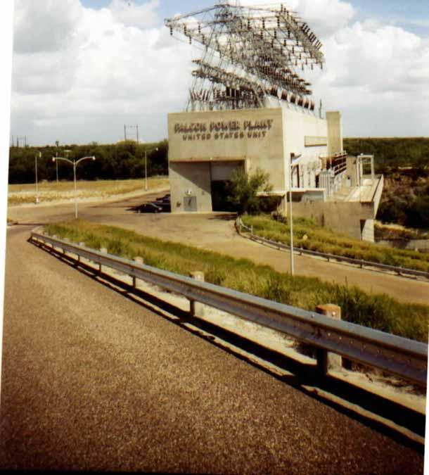
24 U.S. Hydroelectric Plant
25 LOWER RIO GRANDE FLOOD CONTROL PROJECT 340 miles of levee Anzalduas Diversion Dam Retamal Diversion Dam Floodways Flood protection for hundreds of thousands of people in the U.S. and Mexico


26 Anzalduas PRESA DERIVADORA Diversion ANZALDUAS Dam 1966 Flood at Brownsville-Matamoros
27 SANITATION PROJECTS 3 international wastewater treatment plants San Diego, CA Nogales, AZ Nuevo Laredo, Tamaulipas

28 SOUTH BAY INTERNATIONAL WASTEWATER TREATMENT PLANT
29 WATER QUALITY MONITORING 3 Rio Grande binational toxic substances studies Binational toxic substances study of the New and Colorado Rivers Intensive water quality monitoring study of the Rio Grande at Laredo-Nuevo Laredo
30 COLORADO RIVER SALINITY CONTROL Minute 242 (1973) regulates the salinity of water delivered to Mexico Wellton Mohawk Canal bypasses saline flows to the Santa Clara Slough in Mexico Desalination plant in the U.S. can be made operational when needed
31 WATER ACCOUNTING More than 50 gaging stations in the Rio Grande basin in the United States and Mexico 11 gaging stations on the Colorado River Data reviewed weekly by the U.S. and Mexican Sections Determination of the national ownership of waters of the Rio Grande Publication of flow data, rainfall, reservoir storage, evaporation, and water quality data in annual water bulletins


32 WATER ACCOUNTING Telemetry system at North Floodway, Lower Rio Grande Rio Grande gaging station at Presidio-Ojinaga
33 INTERNATIONAL BOUNDARY AND WATER COMMISSION, UNITED STATES AND MEXICO Mexican Section U.S. Section (656) (915)
Dr. Christopher Brown New Mexico State University GEF Project Rio Meeting Ciudad Juárez, México 3-5 October 2006
 Political and Institutional Aspects of Rio Grande/ Río Bravo Basin Management Dr. Christopher Brown New Mexico State University GEF Project Rio Meeting Ciudad Juárez, México 3-5 October 2006 Institutional
Successful Experiences in Rio Grande/Rio Bravo Watershed Management
 Successful Experiences in Rio Grande/Rio Bravo Watershed Management 5 th th World Water Forum Istanbul, Turkey March 22-23, 23, 2009 Introduction A watershed with many voices a medley of cultures, customs,
A Brief Overview of the Rio Grande Compact 04/26/06
 A Brief Overview of the Rio Grande Compact 04/26/06 The New Mexico Interstate Stream Commission Investigate, Protect, Conserve, and Develop the State s Waters and Stream Systems Negotiate and Administer
DROUGHT AND SCARCITY PLANS IN THE BRAVO RIVER BASIN
 DROUGHT AND SCARCITY PLANS IN THE BRAVO RIVER BASIN Sergio Soto-Priante Deputy Director General Sub Direction of Hydraulic Infrastructure for Agriculture National Water Commission (Mexico) February 2009.
Guide to MS416 Albert Bettle Papers
 University of Texas at El Paso DigitalCommons@UTEP Finding Aids Special Collections Department 6-26-2017 Guide to MS416 Albert Bettle Papers Armand J. Avila The University of Texas at El Paso Follow this
Servicios de Agua y Drenaje de Monterrey, I.P.D. Proyecto Monterrey VI 1
 Emilio Rangel Woodyard Director General Water and Sewerage Service of Monterrey Tel: +5181-2033-7001 E-mail: erangel@sadm.gob.mx y/o cavila@sadm.gob.mx MONTERREY VI PROJECT Servicios de Agua y Drenaje
Water Use for Agriculture in Priority Rivers Basins
 Water Use for Agriculture in Priority Rivers Basins Section 1 Section 2 Section 3 Section 4 Section 5 Section 6 Section 7 Section 8 Executive Summary Introduction Water Resources A Global Perspective Africa:
One Source, Multiple Challenges: The Future Evolution of Water Policy and the Case of the Colorado River
 One Source, Multiple Challenges: The Future Evolution of Water Policy and the Case of the Colorado River David H. Getches Dean and Raphael J. Moses Professor of Natural Resources Law University of Colorado
Income in the border region,
 Income in the border region, 1993-2010 NAFTA at Twenty: Effects on the North American Market Federal Reserve Bank of Dallas, Houston Branch June 5-6, 2014 Dr. James Gerber Professor of Economics San Diego
INTRODUCTION 250,000
 INTRODUCTION The United States of America has over 250,000 rivers, with a total of about 3,500,000 miles of rivers. The main stems of 38 rivers in the United States are at least 500 miles (800 km) long.
Documentation and Testing of the WEAP Model for the Rio Grande/Bravo Basin
 CRWR Online Report 06 08 Documentation and Testing of the WEAP Model for the Rio Grande/Bravo Basin by Constance L. Danner, M. S. Daene C. McKinney, Ph.D., PE Rebecca L. Teasley, M. S. and Samuel Sandoval
7KH'LVSXWH2YHU6KDUHG:DWHUVRIWKH 5tR*UDQGH5tR%UDYR
 7KH'LVSXWH2YHU6KDUHG:DWHUVRIWKH 5tR*UDQGH5tR%UDYR $3ULPHU Photo: The Confluence of the Río Grande and Río Conchos near Presidio/Ojinaga www.texascenter.org/borderwater -XO\ Overview This short primer is
Closure Method County State Laguna Pueblo 404(F) Activity not. Activity not. Activity involve discharge into NONwaters.
 Activity not. Activity not. Activity involve discharge into NONwaters.") DA Number 00273-00291- 00295-00298- 00304- Action Type Project Name End Date Closure Method County State Laguna Pueblo Irrigation/Diversion Structure Maintenance, Seboyeta Creek, Cibola County 9-Jul-12
DA Number 00273-00291- 00295-00298- 00304- Action Type Project Name End Date Closure Method County State Laguna Pueblo Irrigation/Diversion Structure Maintenance, Seboyeta Creek, Cibola County 9-Jul-12
EL PASO S DESALINATION EFFORTS
 El Paso s Desalination Efforts WATER DESALINATION AND REUSE STRATEGIES FOR NEW MEXICO SEPTEMBER NEW MEXICO WATER RESOURCES RESEARCH INSTITUTE 2004 Bill Hutchison has more than 20 years of experience as
Utah Nevada California Arizona New Mexico Baja California Texas Sonora Chihuahua Coahuila de Zaragoza Sinaloa Durango Nuevo León Zacatecas San Luis
 Nevada Utah California Arizona New Mexico Baja California Sonora Texas Chihuahua Coahuila de Zaragoza Sinaloa US States Mexico States International Boundary Durango Nayarit Zacatecas Jalisco Nuevo León
Colorado s Compacts. Craig Cotten Division Engineer
 Colorado s Compacts Craig Cotten Division Engineer 19 States & Mexico Rely on Colorado Water Methods of Allocating Water Between States Litigation Court Decides Federal Federal Government Decides Agreement
TECHNICAL ASSISTANCE REPORT SEPTEMBER 2012
 NORTH AMERICAN DEVELOPMENT BANK TECHNICAL ASSISTANCE REPORT SEPTEMBER 2012 The North American Development Bank (NADB) uses a portion of its retained earnings to offer technical assistance and training
NATIONWIDE PERMIT ACTIONS JULY - SEPTEMBER Action Type Project Name Closure Method County State SPA SCO NWP River West Development
 DA Number Action Type Project Name Closure Method County State SPA-2013-00282- River West Development Chaffee CO SPA-2010-00457 Delbert Smith Conejos CO SPA-2010-00457 Delbert Smith Conejos CO SPA-2013-00379
Industrial Report. Americas Research. Northeast Mexico 4Q 2013
 Industrial Report Americas Research Northeast Mexico 4Q 2013 Northeast Mexico Industrial Overview The Northeast markets have had a considerable rise in activity. The Monterrey Metropolitan area has registered
Sulphur Creek Wetlands Restoration Project in the Valles Caldera National Preserve, Sandoval County, New Mexico
 DA Number Action Type Project Name Closure Method County State SPA-2015-00107-ABQ Sulphur Creek Wetlands Restoration Project in the Valles Caldera National Preserve, Sandoval County, New Mexico Sandoval
NATIONWIDE PERMIT ACTIONS APRIL - JUNE 2014
 DA Number 00385-LCO 00123 00124 00073 00075 00430 00043-SCO 00062-SCO 00062-SCO 00183-SCO 00195-SCO 00264-SCO 00272-SCO 00278-SCO 00282-SCO Action Type Name Closure Method County State Kingston Road and
Natural Resources Journal
 Natural Resources Journal 40 Nat Resources J. 2 (Spring 2000) Spring 2000 Mining of Internationally Shared Aquifers: The El Paso-Juarez Case Octavio E. Chavez Recommended Citation Octavio E. Chavez, Mining
Appendix A Detailed Study Area Descriptions
 Appendix A Study Area Description Appendix A Detailed Study Area Descriptions This Appendix provides more detailed descriptions of the geography and hydrology of the five transboundary regions that make
No UNITED ARAB REPUBLIC and SUDAN Agreement (with annexes) for the full utilization of the Nile waters. Signed at Cairo, on 8 November 1959
 for the full utilization of the Nile waters. Signed at Cairo, on 8 November 1959") UNITED ARAB REPUBLIC and SUDAN Agreement (with annexes) for the full utilization of the Nile waters. Signed at Cairo, on 8 November 1959 Official text: Arabic. Registered by the United Arab Republic on
UNITED ARAB REPUBLIC and SUDAN Agreement (with annexes) for the full utilization of the Nile waters. Signed at Cairo, on 8 November 1959 Official text: Arabic. Registered by the United Arab Republic on
Latin America s Physical Geography. EQ: What are characteristics of Latin America s physical features?
 Latin America s Physical Geography EQ: What are characteristics of Latin America s physical features? Your Task: We are going to participate in a Museum Walk! You will travel around the room with a partner
No, Agreement relating to emergency deliveries of Colorado. maps and scheduie). Adopted at Ciudad Juiirez on.
. Adopted at Ciudad Juiirez on.") No, 16559 UNITED STATES OF AMERICA and MEXICO Agreement relating to emergency deliveries of Colorado River waters for use in Tijuana. Effected by Minute No. 240 of the International Boundary and Water
No, 16559 UNITED STATES OF AMERICA and MEXICO Agreement relating to emergency deliveries of Colorado River waters for use in Tijuana. Effected by Minute No. 240 of the International Boundary and Water
Phoenix Habitat Restoration Projects
 Phoenix Habitat Restoration Projects Spur Cross Ranch Cave Creek (Estergard) Regional Tree and Shade Summit March 9, 2010 Desert Riparian Ecosystems Healthy riparian areas like this once existed along
The Mississippi River Commission. History of the Management of the Mississippi River. US Army Corps of Engineers BUILDING STRONG
 The Mississippi River Commission History of the Management of the Mississippi River US Army Corps of Engineers US Army Corps of Engineers Presentation Outline Overview of Mississippi River History of Mississippi
MIÑO O AND LIMIA BASINS
 Miño-Sil MIÑO O AND LIMIA BASINS José Álvarez Díaz Sil River Basin District s s Planning Office, Spain WORKSHOP ON TRANSBOUNDARY WATER RESOURCES BUDAPEST, HUNGARY, 8-10 FEBRUARY 2011 INDEX 1. OVERVIEW
Guide to MS652 El Paso Document Collection
 University of Texas at El Paso DigitalCommons@UTEP Finding Aids Special Collections Department 10-2017 Guide to MS652 El Paso Document Collection Abbie Weiser University of Texas at El Paso, ahweiser@utep.edu
Kiwanis International
 Page 1 of 7 Southwest 02 Division 2 K0003A Albuquerque NM 79 76 76 76 76 77 84 85 85 7.59 +6 K04781 Aztec NM 5 5 5 5 5 5 5 5 5 0.00 K147 Bloomfield NM 4 4 4 4 4 4 4 4 4 0.00 K08906 Coronado, Albuquerque
Summary of Global Perspectives
 Baja California: California`s Partner José Guadalupe Osuna Millán Baja California State Governor October 2009 World Economic Outlook Summary of Global Perspectives Percentage change last year, except interest
COMPETITIVE ADVANTAGES
 COMPETITIVE ADVANTAGES Celaya offers an strategic localion in the geographical center of Mexico. In the denominated Golden triangle that its is integrated by the cities of México, Monterrey and Guadalajara.
Port Cooperation & Logistic Development in Emerging Markets
 New Exploration in the Transitional Era BIPC, 2017 Port Cooperation & Logistic Development in Emerging Markets Fernando Gamboa Director General of Ports Authorities Management & Development Coordination
PORT OF MATAMOROS ADMINISTRACIÓN PORTUARIA INTEGRAL DE TAMAULIPAS, S.A. DE C.V. H. MATAMOROS, TAMAULIPAS.
 ADMINISTRACIÓN PORTUARIA INTEGRAL DE TAMAULIPAS, S.A. DE C.V. H. MATAMOROS, TAMAULIPAS. 2018 STRATEGIC LOCATION Port of Matamoros sits on the Gulf of Mexico in the northern part of the state of Tamaulipas,
Unit 13: La Entrada The Spanish Enter New Mexico
 Assessment Activities: Student Activity Sheet Activity 1. Matching Place Names Draw a line to connect the Spanish Place Name with its English definition. 1. Los Alamos a. mayor 2. Española b. the stream
2012 Texas Water Conservation Association Meeting
 2012 Texas Water Conservation Association Meeting BG Thomas Kula Southwestern Division Commander 15 June 2012 US Army Corps of Engineers AGENDA UNCLASSIFIED Overview of Southwestern Division Missions Texas
LNG Regulatory Issues
 13 th Annual Latin American Energy Conference Institute of the Americas LNG Regulatory Issues La Jolla, California January 30, 2004 Alberto de la Fuente Comisión Reguladora de Energía Index I. Why LNG?
Actual Climatic Conditions in ERB. Online Resource 1 corresponding to:
 Actual Climatic Conditions in ERB. Online Resource 1 corresponding to: Article Title: Climatic Trends and Impact of Climate Change on Agriculture in an Arid Andean Valley. Journal Name: CLIMATIC CHANGE
Industrial Market Report
 Industrial Report Northeast Mexico 1Q 2014 Tamaulipas, Nuevo Leon, Coahuila, Chihuahua Americas Research Northeast Mexico Industrial Overview JLL s Industrial Services is a dedicated team focused 100%
Spanish Colonies on the Borderlands
 Spanish Colonies on the Borderlands Pages 90 93 Nov 1 8:14 PM 1 Today's Objectives *Describe Spain s colony in Florida. *Explain how Spain established settlements throughout much of North America. *Describe
Victory Packaging 3555 Timmons Lane, Suite 1400, Houston, TX, 77027, USA and the sites as mentioned in the appendix accompanying this certificate
 C ertificate N o: 2 4 9 256-2017-AQ--ANAB I nitial c ertification date: 0 1 N ovember 2 017 V alid: 0 1 N ovember 2 017-1 1 N ovember 2 019 This is to certify that the management system of 3555 Timmons
4th Grade Third 9 Weeks Test
 4th Grade Third 9 Weeks Test Multiple Choice Identify the choice that best completes the statement or answers the question. 1 A waterway for ships that is dug across land is called a. A port C river B
The Desert Southwest. The Desert Southwest OVERVIEW. Regional Landscape Studies. Desert Southwest 5/6/2016 DATES TO REMEMBER
 DATES TO REMEMBER May 2: Course evaluation period begins. Check your Hunter e-mail for instructions. Use your Hunter netid and password: Smartphone: www.hunter.cuny.edu/mobilete Computer: www.hunter.cuny.edu/te
Taos Pueblo, New Mexico
 Taos Pueblo, New Mexico The Southwest Border Area Precipitation Climates of the US U.S. and Canada The Southwest Border Area A region of three dominating cultures: Native American, Spanish American, and
Schedules of Customs Offices Via Cargo Area. CUSTOMS AGUA PRIETA Importation. From Monday to Friday 9:00 to 18:00 hrs. Saturday 9:00 to 11:00 hrs.
 Schedules of Customs Offices Via Cargo Area Customs Office/: Schedules: CUSTOMS AGUA PRIETA Importation. From Monday to Friday 9:00 to 18:00 hrs. Saturday 9:00 to 11:00 hrs. Exportation. From Monday to
The Danube Experience
 The Danube Experience Dealing with Hydromorphological Issues the Danube Experience Philip Weller Executive Secretary, ICPDR Danube River Basin- Overview The Danube River Basin is the most international
Population (million) % of Africa
 % of Africa") FAO. Irrigation in in figures: AQUASTAT Survey 2005 TABLE 1 al distribution of cultivable and cultivated areas Cultivable areas Cultivated areas in 2002 In cultivable areas (ha) (ha) (%) Northern 65 320
FAO. Irrigation in in figures: AQUASTAT Survey 2005 TABLE 1 al distribution of cultivable and cultivated areas Cultivable areas Cultivated areas in 2002 In cultivable areas (ha) (ha) (%) Northern 65 320
Mexico's El Cuchillo Dam Project
 University of Miami Law School Institutional Repository University of Miami Inter-American Law Review 1-1-1997 Mexico's El Cuchillo Dam Project Raúl M. Sánchez Follow this and additional works at: http://repository.law.miami.edu/umialr
4180 acre-feet minimum conservation pool
 MEMORANDUM Subject: Bear River Basin Plan SULPHUR CREEK RESERVOIR Date: July 20, 2000 Location: Section 34, Township 14N, Range 119W. Located on Sulphur Creek, tributary to the Bear River. Located approximately
International Osoyoos Lake Board of Control Annual Report to the International Joint Commission
 International Osoyoos Lake Board of Control 2013 Annual Report to the International Joint Commission TABLE OF CONTENTS ACTIVITIES OF THE BOARD... 1 HYDROLOGIC CONDITIONS IN 2013... 2 Drought Criteria...
Verified With Special
 NATIONWIDE PERMIT ACTIONS OCT - DEC 2012 DA Number 00268-DR 00284- Action Type Project Name End Date NMDOT Reconstruction of US64, MP 60-62, West of Bloomfield, 18-Oct-12 Best, Acequia de la Otra Banda,
Infrastructure in Mexico
 Infrastructure in Mexico Alonso Quintana Chief Financial Officer Empresas ICA, S.A.B. de C.V. Mexico City February 16, 2010 National Infrastructure Plan 2007-2012: Requirements and Goals by Sector Sector
BORDER WEST EXPRESSWAY (LOOP 375)
") BORDER WEST EXPRESSWAY (LOOP 375) 2015 Project Update Agenda 1 2 3 4 Team Overview Project Details Questions 2 Teams Owner Texas Department of Transportation Independent Engineer HDR Engineering Atkins
BORDER WEST EXPRESSWAY (LOOP 375) 2015 Project Update Agenda 1 2 3 4 Team Overview Project Details Questions 2 Teams Owner Texas Department of Transportation Independent Engineer HDR Engineering Atkins
SECTION 3 GENERAL DESCRIPTION OF THE RIVER BASIN
 SECTION 3 GENERAL DESCRIPTION OF THE RIVER BASIN SECTION 3 GENERAL DESCRIPTION OF THE RIVER BASIN River basin description. A general description of the river basin or subbasin, as appropriate, in which
Paso Del Norte Economic Indicator Review Spring 2015 UNIVERSITY OF TEXAS AT EL PASO
 Paso Del Norte Economic Indicator Review Spring 2015 UNIVERSITY OF TEXAS AT EL PASO Introduction The Paso del Norte region, comprising West Texas, New Mexico, and Chihuahua, has stood, for millennia, at
International Osoyoos Lake Board of Control Annual Report to the International Joint Commission
 International Osoyoos Lake Board of Control 2010 Annual Report to the International Joint Commission TABLE OF CONTENTS ACTIVITIES OF THE BOARD... 1 HYDROLOGIC CONDITIONS IN 2010... 2 Drought Criteria...
Colorado Springs Utilities Spring 2016 Update. CEO Jerry Forte Leon Young Service Center, April 13, 2016
 Colorado Springs Utilities Spring 2016 Update CEO Jerry Forte Leon Young Service Center, April 13, 2016 1 Spring 2016 Update Today s Discussion 2015 highlights Bright energy future Cleaner air Southern
35. SUPPLEMENTARY BOUNDARY TREATY 1 BETWEEN ARGENTINA AND PARAGUAY, SIGNED AT BUENOS AIRES, JULY
 Title: Supplementary boundary treaty between Argentina and Paraguay on the river Pilcomayo Parties: Argentina, Paraguay Basin: Pilcomayo Date: 6/1/1945 Argentina-Paraguay 35. SUPPLEMENTARY BOUNDARY TREATY
Annual Report to the. International Joint Commission. from the. International Osoyoos Lake Board of Control for
 Annual Report to the International Joint Commission from the International Osoyoos Lake Board of Control for Calendar Year 2005 INTERNATIONAL JOINT COMMISSION International Osoyoos Lake Board of Control
Waterways and Floods. by Michael Pearce. Smith-Layton Archive. Sponsored by Linda L. Lester
 Smith-Layton Archive Waterways and Floods Charlene Duval, Executive Secretary cduval@sourisseauacademy.org Leilani Marshall, Archivist lmarshall@sourisseauacademy.org by Michael Pearce Phone: 408 808-2064
1. International Conventions 2. South African Legislation 3. Swaziland Legislation
 A. Legal context WATER FOR EVER 1. International Conventions 2. South African Legislation 3. Swaziland Legislation B. Evolution of KOBWA 1. Treaties 2. Evolution Stages 3. Main Objectives 4. Need for Bi-national
Module 1 Educator s Guide: Representative Discussion Points Investigation 3
 Module 1 Educator s Guide: Representative Discussion Points Investigation 3 Ethiopia and Eritrea Our combined population is 59,578,171 people. We have just emerged from a long period of civil war and famine.
Project Overview. Step 2: Quantifying the Economic Impact of Visitors to Gold Butte. Step 1: Estimating the Stabilized Visitor Count to Gold Butte
 Project Overview Objective: To estimate the economic impacts of designating Gold Butte as a National Conservation Area Approach: Applied Analysis (AA) employed a two-step analytical approach to quantify
DIRECT PUBLIC INVESTMENT
 DIRECT PUBLIC INVESTMENT - Upgrade and Rehabilitation of Route 11 CH - Optimization of Route 41 CH - Improvement of Route E-30-F - Upgrade of Route 7 by sections - Provincial Hospital of Curicó - Calama
Industrial Market Report
 Industrial Report Northeast Mexico 1Q 2016 Tamaulipas, Nuevo León, Coahuila, Chihuahua Americas Research Northeast Mexico Industrial Overview JLL s Industrial Services is a dedicated team focused 100%
MANAGING GEOGRAPHIC SCOPE. AUTHORITY Gulf of Maine Council on the Marine Environment
 -United States Transboundary Water Governance : Maine, New Hampshire, Vermont, Nova Scotia,, Prince Edward Island and Newfoundland & Labrador These tables represent the range of -United States transboundary
Catchment and Lake Research
 LARS 2007 Catchment and Lake Research Multilateral versus bilateral agreements for the establishment of river based organizations: comparison of legal, economic and social benefits in the Zambian experience.
Bat Cave Canyon Ranch 2,920 acres Jeff Davis County, Texas
 Bat Cave Canyon Ranch 2,920 acres Jeff Davis County, Texas James King, Agent Office 432.426.2024 Cell 432.386.2821 James@KingLandWater.com Bat Cave Canyon Ranch 2,920 acres Jeff Davis County, Texas James
ARIZONA HISTORICAL SOCIETY 949 East Second Street Library and Archives Tucson, AZ (520)
") ARIZONA HISTORICAL SOCIETY 949 East Second Street Library and Archives Tucson, AZ 85719 (520) 617-1157 ahsref@azhs.gov PC 078 Mathews, Rena, 1874-1962 Photograph collection, 1900-1962 DESCRIPTION Photograph
ARIZONA HISTORICAL SOCIETY 949 East Second Street Library and Archives Tucson, AZ 85719 (520) 617-1157 ahsref@azhs.gov PC 078 Mathews, Rena, 1874-1962 Photograph collection, 1900-1962 DESCRIPTION Photograph
MS077 Southern Pacific Railroad Records Legal Department-Corporate Files (LCP) Inventory Compiled by Marsha Labodda
 Inventory Compiled by Marsha Labodda") MS077 Southern Pacific Railroad Records Legal Department-Corporate Files (LCP) Inventory Compiled by Marsha Labodda Box # File Folder # Description Dates LCP-1 Contains Certificate of Incorporation and
MS077 Southern Pacific Railroad Records Legal Department-Corporate Files (LCP) Inventory Compiled by Marsha Labodda Box # File Folder # Description Dates LCP-1 Contains Certificate of Incorporation and
CHURCH AVENUE CHULA VISTA, CA 91910
 For Additional Information: Sean Bascom 619.916.9179 bascom@scc1031.com Lic# 01862044 CHURCH AVENUE CHULA VISTA, CA 91910 CHULA VISTA DEVELOPMENT OPPORTUNITY Excellent Location Near Vibrant Third Avenue
The Santa Cruz Valley National Heritage Area. National Heritage Area. A heritage-based economic development strategy
 The Santa Cruz Valley National Heritage Area National Heritage Area A heritage-based economic development strategy Santa Cruz Valley Heritage Alliance Our Mission: Connect people to the cultural, historic,
Seawater Desalination Plant Cabo San Lucas, B.C.S., Mexico
 Seawater Desalination as an alternative solution for potable water in Mexico Seawater Desalination Plant Cabo San Lucas, B.C.S., Mexico INTRODUCTION About 75% of Earth s surface is water, of this quantity,
Rail in Mexico: Innovative Solutions for a Vibrant and Growing Mexican Economy
 Rail in Mexico: Innovative Solutions for a Vibrant and Growing Mexican Economy José Zozaya President, General Manager and Executive Representative Kansas City Southern de México General Overview of KCSM
112th CONGRESS. 1st Session H. R. 113 IN THE HOUSE OF REPRESENTATIVES
 HR 113 IH 112th CONGRESS 1st Session H. R. 113 To provide for additions to the Cucamonga and Sheep Mountain Wilderness Areas in the Angeles and San Bernardino National Forests and the protection of existing
MARCHING AHEAD. Water Conservation through Public Participation FOR HINDI EDITION SEE PAGE NO.53. For Official Circulation only
 BILINGUAL MONTHLY MAGAZINE VOL-4 ISSUE-5 MAY 2018 GUJARAT For Official Circulation only MARCHING AHEAD FOR HINDI EDITION SEE PAGE NO.53 WATER IS LIFE Water Conservation through Public Participation facebook.com/cmoguj
Appendix N MAINTENANCE DREDGING STATEMENT OF NEED & PERMIT COMPLIANCE. North Thousand Islands Management Plan Appendices
 Appendix N MAINTENANCE DREDGING STATEMENT OF NEED & PERMIT COMPLIANCE North Thousand Islands Management Plan Appendices Maintenance Dredging Statement of Need & Permit Compliance The waterways, which consist
Month June 2011 South America (except Colombia for HA) Date of submission 01/07/11 MONTHLY REPORT
 Date of submission 01/07/11 MONTHLY REPORT") ANNEX IV-3 EUROPEAN COMMISSION HUMANITARIAN AID OFFICE (ECHO) Monthly report number 2011/6 Month June 2011 Country South America (except Colombia for HA) Date of submission 01/07/11 Author ECHO Quito MONTHLY
ANNEX IV-3 EUROPEAN COMMISSION HUMANITARIAN AID OFFICE (ECHO) Monthly report number 2011/6 Month June 2011 Country South America (except Colombia for HA) Date of submission 01/07/11 Author ECHO Quito MONTHLY
Chapter 12 Manifest Destiny ( ) Section 3 War With Mexico
 Section 3 War With Mexico") Assess your agreement with the following statement: The United States government acted morally in its acquisition of the land of the present-day continental United States. A. Strongly agree B. Somewhat
Assess your agreement with the following statement: The United States government acted morally in its acquisition of the land of the present-day continental United States. A. Strongly agree B. Somewhat
Mississippi River & Tributaries Project History & Overview
 Mississippi River & Tributaries Project History & Overview Watershed Division Mississippi Valley Division 17 June 2015 US Army Corps of Engineers BUILDING STRONG Lake Texoma Spillway Tulsa Little Rock
Withdrawn Due To No Permit Required (NPR) Baca CO. Verified Without Special Conditions Chaffee CO. Verified Without Special Conditions Chaffee CO
 Baca CO. Verified Without Special Conditions Chaffee CO. Verified Without Special Conditions Chaffee CO") DA Number 00045-00057 NWP 00118 NWP 00477- NATIONWIDE PERMIT ACTIONS JAN - MAR 2013 Action Type Project Name End Date Railroad Bridge 190.22 Replacement, BNSF Railway Company, Two Butte Creek Tributary,
DA Number 00045-00057 NWP 00118 NWP 00477- NATIONWIDE PERMIT ACTIONS JAN - MAR 2013 Action Type Project Name End Date Railroad Bridge 190.22 Replacement, BNSF Railway Company, Two Butte Creek Tributary,
International Osoyoos Lake Board of Control Annual Report to the International Joint Commission
 International Osoyoos Lake Board of Control 2015 Annual Report to the International Joint Commission Cover: Northern extent of Osoyoos Lake, where the Okanagan River enters the lake, 2015. View is to the
HYDROELECTRIC POWER PLANTS ON THE LOWER SAVA RIVER
 HYDROELECTRIC POWER PLANTS ON THE LOWER SAVA RIVER The construction of a chain of hydroelectric power plants on the lower course of the Sava River is a multi-purpose project that makes a significant contribution
AMERICAN INDUSTRIES. 40 years committed with Mexico.
 AMERICAN INDUSTRIES American Industries Group was founded in 1976 with the sole mission of ensuring the successful establishment and operation of global businesses in Mexico. American Industries will guide
OFFICE OF THE SECRETARY OF ECONOMIC DEVELOPMENT
 OFFICE OF THE SECRETARY OF ECONOMIC DEVELOPMENT Colima, Mexico Tel: +52 (312) 316-2028 Fax: +52 (312) 316-2034 E-mail: sefome@col.gob.mx Infrastructure Colima's modern and well-developed infrastructure
MANAGING FRESHWATER INFLOWS TO ESTUARIES
 MANAGING FRESHWATER INFLOWS TO ESTUARIES Yuna River Hydrologic Characterization A. Warner Warner, A. (2005). Yuna River Hydrologic Characterization. University Park, Pennsylvania: The Nature Conservancy.
Anzalduas Industrial Business Park
 McALLEN- EDINBURG MISSION MSA Mission Industrial Park is in Hidalgo County, located in the McAllen-Edinburg-Mission Metropolitan Statistical Area (MSA). The McAllen MSA encompasses 1,583 sq. mi. and is
CHULA VISTA DEVELOPMENT OPPORTUNITY. For Additional Information: Sean Bascom Lic#
 For Additional Information: Sean Bascom 619.916.9179 bascom@scc1031.com Lic# 01862044 CHULA VISTA DEVELOPMENT OPPORTUNITY Excellent Location Near Vibrant Third Avenue Village High Density Zoning Building
Index to Major Southern Pacific Company Files of importance
 Abbreviations used Meaning of Series Codes used: AUD Audit; DE Division of Engineer; GCA General Claim Agent; GFA General Freight Agent; GPA General Passenger Agent; GSO General Superintendent s Office;
230 CHURCH AVENUE CHULA VISTA, CA 91910
 Excellent Location Near Vibrant Third Avenue Village High Density Zoning Building Height up to 45 Lot size of 11,326 sqft Flat/Graded Lot Ease of Access to Utility Hookups Multiple Allowed Uses For Additional
EAST VALLEY PARKWAY FOR SALE - RESIDENTIAL DEVELOPMENT OPPORTUNITY 3141 E. VALLEY PARKWAY ESCONDIDO, CA ACRE SITE $1,100,000
 3141 E. VALLEY PARKWAY ESCONDIDO, CA 92027-5219 3.31 ACRE SITE $1,100,000 OFFERING HIGHLIGHTS Valley High School Residential Development Opportunity Close to Frances Ryan Park & Multiple Schools Settled
Projected Supply and Demand for Natural Gas over the next 10 years and Plans for Major LNG Receiving Terminals March 11, 2003 Houston, Texas
 2 nd Annual LNG North America Conference Projected Supply and Demand for Natural Gas over the next 10 years and Plans for Major LNG Receiving Terminals March 11, 2003 Houston, Texas Index I. Regulatory
1803 West Hwy 160 Monte Vista, CO (719) TTY (719)
 TTY (719)") USDA Forest Service Rio Grande National Forest http://www.fs.fed.us/r2/riogrande 1803 West Hwy 160 Monte Vista, CO 81144 (719)852-5941 TTY (719)852-6271 USDI Bureau of Land Management San Luis Valley Center
USDA Forest Service Rio Grande National Forest http://www.fs.fed.us/r2/riogrande 1803 West Hwy 160 Monte Vista, CO 81144 (719)852-5941 TTY (719)852-6271 USDI Bureau of Land Management San Luis Valley Center
Transboundary Water Management in Republic of Macedonia
 12th International Conference EUROPE-INBO 2014 12-15 November 2014, Bucharest, Romania. Transboundary Water Management in Republic of Macedonia Ylber Mirta Head of Department for Waters ymirta@gmail.com
Fruit and Vegetable TRUCK RATE REPORT
 Fruit and Vegetable TRUCK RATE REPORT United States Agricultural Marketing Service 2202 Monterey St. Suite 104-F Department of Fruit and Vegetable Programs Fresno, CA 93721 Agriculture Market News Division
AVAILABLE PROPERTIES
 Aguascalientes, Ags. BUILDING II FINSA Aguascalientes Aguascalientes-Mexico Highway Km. 114.5, Aguascalientes, Aguascalientes 108,295 SF Precast concrete walls Pre-engineered standing seam 3% LEED Registration
FOR LEASE 4,640 SF FREESTANDING BUILDING
 967 CAMINO DEL RIO S SAN DIEGO, CA 92108 FOR LEASE 4,640 SF FREESTANDING BUILDING TOMMAS GOLIA Associate Vice President D: 858 598 2891 Tommas@PacificCoastCommercial.com Lic. 01890744 JASON VIEIRA Senior
01T_ODD2_DCH 01T_ODD3_ARN
 01T_ODD2_DCH Duck Pond Agricultural Drains / Mugu Drain / Oxnard Drain No. 2. The monitoring site is located on an agricultural drain just south of Hueneme Road near the Duck Ponds. Flow from this drain
Water Management in the United States and the Fate of the Colorado River Delta in Mexico
 University of Colorado Law School Colorado Law Scholarly Commons Articles Colorado Law Faculty Scholarship 2003 Water Management in the United States and the Fate of the Colorado River Delta in Mexico