Santo Domingo de la Calzada - Belorado
|
|
|
- Violet Cross
- 5 years ago
- Views:
Transcription

1 Santo Domingo de la Calzada - Belorado From open country to Gypsum NATURE ON THE WAY OF ST JAMES


2 Published by: Caja de Burgos Fundación Patrimonio Natural de Castilla y León Text: Aula de Medio Ambiente Caja de Burgos Miguel A. Pinto Cebrián y Juan Carlos Utiel Alfaro Photography: Aula de Medio Ambiente Caja de Burgos Miguel A. Pinto Cebrián y Juan Carlos Utiel Alfaro Nacho Contreras Fernández Jorge Martín Muñoz Illustrations: Aula de Medio Ambiente Caja de Burgos Miguel A. Pinto Cebrián Maps: Translation: Rico Adrados Andrew Holland English version review: Carlos García Güemess Design and printing: Imprenta Lomas

3 Santo Domingo de la Calzada - Belorado From open country to Gypsum On the 22 Km. of this leg you will walk in the Ebro River Basin close to its south eastern border. After crossing the river Oja and just before Grañón, the Way passes a mere 500 m. from a remarkable Oak forest, just before entering Burgos province in Redecilla del Camino and leaving La Rioja. You will cross several small streams and on the left, towards the south, the foot hills of Sierra de la Demanda will accompany you and in the distance its highest peak: the rounded mount of St. Lorenzo, m. high. After passing through some villages of La Riojilla Burgalesa and seeing some gypsum in the landscape, you will get to Belorado, end of this stage. This series of pocket guides: Nature on the Way of St James, is fruit of the collaboration agreement between the Social Work Programme of Caja de Burgos and the Natural Heritage Foundation of Castilla y Leon. The object of these pamphlets is to give pilgrims, hikers and inhabitants of the Jacobean area some interesting notes on the nature and landscape of the Way. The stages described are part of the the French Way as it passes through Burgos: Santo Domingo de la Calzada-Belorado; Belorado-San Juan de Ortega; San Juan de Ortega-Burgos; Burgos-Castrojeriz and Castrojeriz-Frómisa, covering the approximate 132 km of the Way in Burgos. We hope that the reader will be able to appreciate and, above all, respect what Nature has to offer and thanks to these simple notes will enjoy and understand the Way a little better.
 can perceptibly alter the shape of waterways Stage 1: Santo Domingo de la Calzada - Grañón River Oja, Course or Quarry The word glera refers to land with a large proportion of")

4 The twisted riverbed indicates the torrential and unsteady character of this river. A water rise (flood) can perceptibly alter the shape of waterways Stage 1: Santo Domingo de la Calzada - Grañón River Oja, Course or Quarry The word glera refers to land with a large proportion of gravel, as can be verified by looking into the river from the bridge. The apparent disproportion between the amount of water in the river and the number of arches and length of the bridge may attract your attention. But the bridge builders knew that the sudden floods of the river Oja could be very violent, carrying everything in their path, including the rocks here deposited. The Glera is a tributary of the river Tirón, just as the other small rivers that flow into the Ebro and which you will cross on this stage: Majuelos, Villar Medio, Rechaliego, Villamayor, Sanchidrián de la Tejera, San Julian and Trambasaguas. The river pebbles are not overly rounded, indicating their relative nearness to their origin in the mountains.
 and from the lower zones (more modern),")

5 Where do the stones come from? The river Oja flows giddily from its source, almost 2000 m. high in Sierra de la Demanda, to 639 m. where you are in about 30 Km. In its descent it has been dislodging, dragging and rounding the rocks from the high part of the sierra (among the oldest in the Peninsula) and from the lower zones (more modern), and depositing them in places like this one where the ground is more level. The energy of countless storms, the river floods and above all, thousand of years of friction have rounded the stones off. The premise that the etymological origin of La Rioja lies in River Oja is not very clear. There are various opinions and studies, some of which support the theory and others not.

6 Wagtails and Martins frequent the River Oja The Wagtails hop over the rolled pebbles while the Martins do acrobatics above the river course. One on the ground, the other in the air, both capture the insects necessary for their diet. They also bathe and drink water. The Martins, Swifts and Swallows can only be seen in spring and summer. In autumn they leave to spend the winter in Africa. Mount San Lorenzo in the distance Small and brown, the Sand Martin makes its nest in earthen river banks The House Martin has a white body With its red face and scissor-like tail the Common Swallow is easy to identify Swifts are totally dark except for a small light patch at the throat The Yellow Wagtail spends winter in Africa The Grey Wagtail likes mountain streams Pied Wagtails are easy to find allyear-round

7 House Sparrow White Stork Collared Dove Other birds frequently found in this area White Storks attract the attention and their nests are easily seen.the Collared Dove, Spotless Starling and House Sparrow make use of the river to bathe and drink. These species have adapted to living in our towns and it is quite possible that you will see them in the next stages. Spotless Starling

8 Plant invaders from east and west Fruit of the Chinese Sumac Leaves of the Chinese Sumac They resist contamination, hardly suffer from plagues, can stand heat and drought they are authentic survivors which triumph where other trees fail. Moreover, they grow and spread very quickly. Thanks to these abilities they have escaped our control and can create serious problems for local trees when they leave the edges of the roads. Although they give an exotic touch to the Way, they are an example of a real threat which is the invasion of species from other places. Flowers of the False Acacia Leaves of the False Acacia These invaders will be seen on the wayside just after leaving the river Oja

9 The Chinese Sumac or Tree of Heaven comes from China. It was brought to Europe in the middle of the 18th century. It invades waysides and river banks The Robinia or False Acacia comes from the USA and was brought to Europe in the 17th century. We can often see it beside churches. It invades the clearings of local woods. Chinese Sumac False Acacia Robinia fruit

10 From the Ebro basin to the country fields In the valleys and zones near rivers, in the flatter areas, the landscape is characterized by the ancestral use of their fertile soils and the proximity of water. What the rivers have pulled down from the mountains is deposited as sediments, rich in nutrients, on the meadows and alluvial plains which are used for cultivation. After leaving behind the river Oja you will now enter the landscape of the lands of the Ebro depression, always with the northern foothills of the Sierra de La Demanda to the south. Here the contours are more rounded.

11 The campiñas are very large and spaceous extensions of land given over to agriculture and resulting in an agrarian landscape very widespread in the Iberian Peninsula. The proximity of the mountain ranges gives a certain variety to this country by the cultivation of the low rolling hills. This landscape will accompany you as far as Villafranca Montes de Oca, on the next leg, where we will enter the Sierras Ibéricas.

12 These lands have been cultivated for many centuries We find ourselves in the Rioja Alta (High Rioja), in the area where cereals, potatoes and, depending on the year, sunflowers predominate. The latter two species come from America and since the 19th century constitute an important part of our diet and of the agrarian landscape. It should be remembered that the Way crosses numerous cultivated lands which seem the same, but if we look closer we will be able to note differences between them. Potato The moving of species between continents has given rise to examples like the Colorado Potato Beetle, which hasn't stopped eating in the potato fields since it arrived in Europe in Colorado Potato Beetle Broad Bean In June it is easy to see Broad Bean crops Sunflower

13 In Grañon there is an island of oaks among the crop-fields One of the most radical changes to the landscape is the substitution of woods for crops. If it were not for small corners like Monte Carrasquedo it would be almost impossible to guess what our country was like centuries ago. This oak wood of Pyrenean and Portuguese oaks is surrounded by crop lands and maintains an interesting representation of forest flora and fauna. It is the VS.07 riojano which means that it is an area of special vegetation and is protected by tha Rioja Government. The Carrasquedo de Grañon can be found only 500 metres from the Way, on your left as you enter the village.


14 Stonechat (female) Stage 2: Grañón - Belorado Red Kite Buzzard Red Kite Stonechat (male)


15 Some birds of the fields Many birds will accompany you on your walk. For example the Corn Bunting share the bushes with Stonechats, Larks run ceaslessly along the Way and Carrion Crows are like black spots in the immensity of the cultivated fields. Crested Lark Carrion Crow There are also birds of prey like the Buzzard which watch the pilgrim's progress from on high whilst the Red Kite hunts food flying over the frozen fields in winter. Corn Bunting Crested Lark Corn Bunting
.")
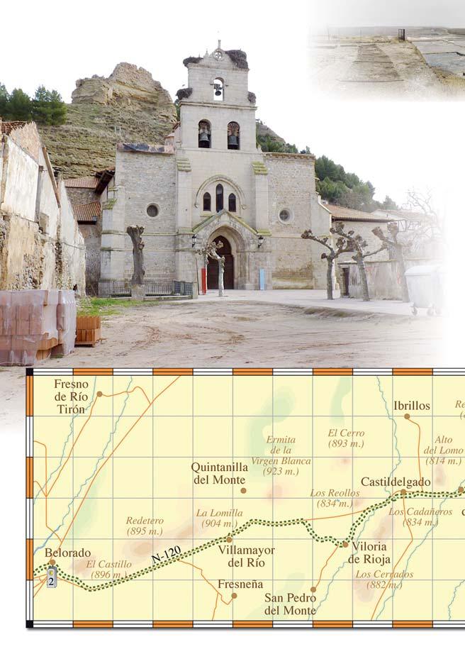
16 Burgos receives you in Redecilla del Camino Municipalities like Bascuñana, Castildelgado, Fresneña, Ibrillos, Redecilla del Camino, Redecilla del Campo, Viloria de Rioja and others, form the Riojilla Burgalesa (Little Rioja of Burgos). A curious name whose origin lies at the beginning of the 16th Century when these lands and a large part of the present La Rioja formed part of the Province of Burgos, heir to the Merindad of Castilla, also covering parts of Palencia Zamora and Cantabria. In 1833 the Province of Logroño separated leaving the lands of Riojilla definitively for Burgos. Historical considerations apart, the continuity of the landscape and the influence of the Ebro and Tirón basins continue their importance and you won't notice a change between the two provinces. Sandstones Church of Villamayor del Rio Gypsums

17 The churches were built with local stone Sandstones You will have noticed that up to now all the churches and hermitages are built of sandstones. Very soon you will see that some have gypsum in their construction. As you advance, the first gypsums will appear, remains of ancient watercourses of the Ebro without access to the sea which in these zones mixed with that of the Duero. After passing Viloria de Rioja you will clearly see them in the countryside to your right, mixed with marl (lime-clay). The ancient hermits constructed their places of prayer here. The first church where you'll find gysums is in Villamayor del Río. It is very costly to transport stone a long way and for this reason the churches are built with stone from the area. Gypsum is easily scratched with the nail

18 Little trees with goblins and dog grapes They are the Elders and Dwarf Elders. The former are woody and reach a considerable size. The latter grow anew every year and form dense groups along the edge of the Way. Both have small white flowers which transform into black berries which attract many birds. Elder Berries The Elder has been considered magic in Europe for being the home of many an elf-like creature. The Dwarf Elder is not so famous, although for its poisonous berries it belongs to the group of plants which produce the non-existent uva de perro (dog grape). Elder leaves Elder

19 The Blackcap visits these plants when they are in fruit Blackcap Dwarf Elder berries Dwarf Elder flowers Elder berries Elder flower Elder leaves

20 Gypsum on the slopes Just at the entrance to Belorado, to the right of Trambasaguas stream, you will walk beside the gypsums of the hillside which have been on your right as you approached. These gypsums formed in enclosed lakeside zones where the very arid climate evaporated the water. This caused the different disolved salts to crystalize into solid form. But not all of them did so together. The Narrow Leaved Bindweed can grow in the gypsum. On hillsides and slopes of gypsum, life is difficult. Plants which live here can resist the hard conditions of these special soils. Also called gypsofiles, you will see a good representation of these plants further on in Castrojeriz.

21 Gypsum Common gypsum is calcium sulphate with some water. After heating and pulverization we obtain the plaster and cement of our homes which, on adding water, forges and hardens quickly. Millions of years ago in Belorado and Cerezo del Rio Tirón, as the salts crystalized in those hyper-saline lakes, other sulphates were formed, almost exclusive in Europe: glauberite is formed of sodium sulphate. This mineral is formed after bicarbonates in relation to calcium and magnesium are dissolved in water. Only after the formation of the gypsum is the glauberite created.
22

23 Belorado, gypsums and glauberite We are European leaders in the production of this mineral, and second in the world after China. The formation of the glauberite and its preservation during millions of years, thanks to it being covered in limy silt, puts at our disposal a source of wealth unique in the world. You should know that when you use detergent, glass or paper, as well as other products, glauberite is an essential component in their manufacture. On your journey to Santiago you can count on the continued company of the wildlife that has evolved in the countryside as a result of the works of Nature and Man. Good Journey! Glauberite

24 For more information: BURGOS - VALLADOLID - PALENCIA caminosantiago@medioambientecajadeburgos.com
Castrojeriz-Frómista. When lakes covered the countryside NATURE ON THE WAY OF ST JAMES
 Castrojeriz-Frómista When lakes covered the countryside NATURE ON THE WAY OF ST JAMES Published by: Caja de Burgos Fundación Patrimonio Natural de Castilla y León Text: Aula de Medio Ambiente Caja de Burgos
Instalment 3 Lograno to Burgos
 Instalment 3 Lograno to Burgos Day eight is an early start from Logrono, 5.30am; the city is in darkness with a feint hint of sunrise. Wayside marks are hard to see, so I have to stay focused or I might
Region 1 Piney Woods
 Region 1 Piney Woods Piney Woods 1. This ecoregion is found in East Texas. 2. Climate: average annual rainfall of 36 to 50 inches is fairly uniformly distributed throughout the year, and humidity and temperatures
GEOGRAPHY AND HISTORY
 GEOGRAPHY AND HISTORY YEAR 1, PART 1 www.vicensvives.es Contents 01 Our planet Earth 02 The representation of the Earth: maps 03 The Earth s relief 04 Rivers and seas 05 Weather and climate 06 Climates
Camino de Santiago FRANCE & SPAIN - FOLLOW THE WAY OF ST JAMES 2018
 Camino de Santiago FRANCE & SPAIN - FOLLOW THE WAY OF ST JAMES 2018 SELF-GUIDED INN-TO-INN WALKING ON THE WAY OF SAINT JAMES From Le Puy in France to Santiago in Spain - daily departures from 1 st May
3rd GRADE MINIMUM CONTENTS UDI 1: LANDSCAPES (5)
") 3rd GRADE MINIMUM CONTENTS UDI 1: LANDSCAPES (5) DIFFERENT LANDSCAPES A landscape is all the things that we see in a place. There are different types of landscapes. Mountain landscapes have mountains and
3rd GRADE MINIMUM CONTENTS UDI 1: LANDSCAPES (5) DIFFERENT LANDSCAPES A landscape is all the things that we see in a place. There are different types of landscapes. Mountain landscapes have mountains and
What Is An Ecoregion?
 Ecoregions of Texas What Is An Ecoregion? Ecoregion a major ecosystem with distinctive geography, characteristic plants and animals, and ecosystems that receives uniform solar radiation and moisture Sometimes
BEST OF THE FRENCH WAY TO SANTIAGO DE COMPOSTELA
 BEST OF THE FRENCH WAY TO SANTIAGO DE COMPOSTELA Walk only the best of the French Way. Walk the full 775 km of the French Way from Saint-Jean-Pied-de-Port on the French side of the Pyrenees to Santiago
CAMINO DE SANTIAGO FOLLOW THE WAY OF ST JAMES IN FRANCE & SPAIN
 CAMINO DE SANTIAGO FOLLOW THE WAY OF ST JAMES IN FRANCE & SPAIN SELF-GUIDED INN-TO-INN WALKING ON THE WAY OF SAINT JAMES From Le Puy in France to Santiago in Spain - daily departures from 1 st May to 30
2.1 What is the climate like?
 José Medeiros This fact sheet allows you to see how varied the countryside is across Brazil. 2.1 What is the climate like? Most of Brazil is in the Southern Hemisphere, where the seasons are the opposite
PARADOR DE SANTO DOMINGO DE LA CALZADA
 PARADOR DE SANTO DOMINGO DE LA CALZADA Parador de Santo Domingo de la Calzada Surroundings Santo Domingo de la Calzada stands beside the banks of the Oja River on a vast plain. The town's founding is linked
RIVER ZADORRA, between Ibaiondo and Gobeo RIVER ZADORRA, FROM GAMARRA MAYOR TO ABETXUKO FROM THE CITY TO THE COUNTRYSIDE ALONG THE RIVER
 RIVER ZADORRA, FROM GAMARRA MAYOR TO ABETXUKO PRACTICAL INFORMATION TIMETABLE OF THE URARTE VEGETABLE GARDENS Winter timetable (from 1st October to 31st March): from 08:30 to 18:15 Summer timetable (from
Paradores on the French Way of Saint James
 Culture & History - Discovering Spain medieval town - Parador Bielsa - Parador Calahorra - Parador León - Parador Lerma - Parador Monforte de Lemos - Parador Santiago de Compostela - Parador Santo Domingo
Chapter 8: Colorado Plateau State Highway 141, Dove Creek to Naturita
 State Highway 141 Dove Creek to (61 miles) Summary: Highway 141 heads north from US Highway 491 about two miles northwest of the town of Dove Creek. Initially, the highway runs through gently rolling farming
Geoscape Toronto The Oak Ridges Moraine Activity 2 - Page 1 of 10 Information Bulletin
 About 13,000 years ago as the Laurentide Ice Sheet melted, glacial meltwater accumulated between the ice sheet and the Niagara Escarpment. This formed a lake basin into which gravel and sand were deposited.
Just how big is Africa?
 The United States China India The United Kingdom Portugal Spain France Belgium Germany The Netherlands Switzerland Italy Eastern Europe Japan 11.7 million sq. miles Just how big is Africa? Chapter 18 Section
Chapter 7 Geography and the Early Settlement of Egypt, Kush, and Canaan
 Chapter 7 Geography and the Early Settlement of Egypt, Kush, and Canaan How did geography affect early settlement in Egypt, Kush, and Canaan? Section 7.1 - Introduction RF/NASA//Corbis This satellite photograph
Pembina Valley Provincial Park. Draft Management Plan
 Pembina Valley Provincial Park Draft Management Plan 2 Pembina Valley Provincial Park Table of Contents 1. Introduction... 3 2. Park History... 3 3. Park Attributes... 3 3.1 Natural... 3 3.2 Recreational...
Module 1 Educator s Guide: Representative Discussion Points Investigation 3
 Module 1 Educator s Guide: Representative Discussion Points Investigation 3 Ethiopia and Eritrea Our combined population is 59,578,171 people. We have just emerged from a long period of civil war and famine.
On the Edge with Mangroves
 On the Edge with Mangroves (Author s Note: This is the twenty-second in a series of articles by members of the City of Sanibel Vegetation Committee dealing with vegetative matters of concern to island
Chapter 7. Geography and the Early Settlement of Egypt, Kush, and Canaan
 Chapter 7 Geography and the Early Settlement of Egypt, Kush, and Canaan Chapter 7 Geography and the Early Settlement of Egypt, Kush, and Canaan How did geography affect early in Egypt Kush, and Canaan?
Death Valley Is a Beautiful but Dangerous Place
 Death Valley Is a Beautiful but Dangerous Place Welcome to This Is America with VOA Learning English. Today we visit one of America s great national parks. It is a place of strange and silent beauty. As
Tours Workshops Activites
 The O MATO Experience 4th 14th September 001 002 003 Tours Workshops Activites 001 Tours 001 2 days; 60 ; 15 p.; 5/5; Tours Waterfall Expedition The by passing Rio Apuau has its source in the very deep
OKLAHOMA HISTORY OKLAHOMA S GEOGRAPHY
 OKLAHOMA HISTORY OKLAHOMA S GEOGRAPHY BOARD QUESTIONS 1) HOW BIG IS OKLAHOMA? 2) HOW MANY COUNTIES ARE IN OKLAHOMA? 3) HOW FAR IS IT FROM OKC TO LAS ANGLES, CALIFORNIA? 4) HOW MANY STATE BORDER OKLAHOMA?
Objective. Students will familiarize themselves with the physical features and climates of Latin America.
 Journal Write KWL What do you KNOW about Latin America? What do you WANT TO KNOW about Latin America? What did you LEARN today that you didn t know before? Latin America Objective Students will familiarize
Community-based Adaptation, Experiences in Bolivia
 Community-based Adaptation, Experiences in Bolivia Clea Paz, Conservation International-Bolivia Stephan Halloy, The Nature Conservancy Ninón Ríos and James Aparicio, Naturaleza y Comunidad-PNCC Oscar Saavedra,,
Pyrenees Coast to Coast
 Pyrenees Coast to Coast 13 th October to 21 st October 2018 The Pyrenees Those of you who have already been to the Pyrenees will agree that it is one of the most fascinating mountain ranges in Europe.
The Azores. Volcanoes, Craters and Lakes. 5 Days. t: e: w:
 The Azores Volcanoes, Craters and Lakes 5 s The Azores are a hidden gem in the mid-atlantic; an archipelago of volcanic islands they are the perfect destination for geography students boasting a startling
North Meadow National Nature Reserve
 Leaflet produced with the support of Cricklade Town Council. North Meadow National Nature Reserve For further information about North Meadow contact: The Senior Reserve Manager The Ebworth Centre, The
Montes Obarenes-Sierra de la Demanda Natural Park
 Montes Obarenes-Sierra de la Demanda Natural Park One week route Burgos Province INTERESTING SIGHTSEEING - Monte Santiago Natural Monument - Montes Obarenes Natural Park - Waterfalls: Salto del Nervión,
Spain Cycling the Camino de Santiago Bike Tour 2018 Individual Self-Guided 8 days / 7 nights
 Spain Cycling the Camino de Santiago Bike Tour 2018 Individual Self-Guided 8 days / 7 nights This is not a standard cycling tour! People from many countries across Europe have been travelling along the
FRANCE & SPAIN CLASSIC LONG DISTANCE PILGRIM TRAIL
 Camino de Santiago FRANCE & SPAIN CLASSIC LONG DISTANCE PILGRIM TRAIL 34 days / 33 nights: St Jean Pied de Port to Santiago de Compostela SELF-GUIDED inn-to-inn walking 2018 The Way of St James, Camino
Home to mangroves- trees that can grow in saltwater Mangroves provide housing for fish Greater Sundas home to endangered birds and other animals
 Home to mangroves- trees that can grow in saltwater Mangroves provide housing for fish Greater Sundas home to endangered birds and other animals Climate in ecosystem varies-lots of biodiversity Sumatra
Ancient Egypt and the Near East
 *O*»f ' i ft Ancient Egypt and the Near East Chapter 7 Chapter 8 Chapter 9 Geography and the Early Settlement of Egypt, Kush, and Canaan The Ancient Egyptian P h a r a o h s Daily Life in Ancient Egypt
FINAL STAG E : 5 T H G R A D E
 NAME COURSE SURNAME CENTRE YOUR TEACHER S NAME FINAL STAG E : 5 T H G R A D E 1. Read Danny s diary and complete his timetable. Remember there are extra words! EXTINCT / WATERFALL / VALLEY / PATH / WOOD
Elephant. Buffalo. Kudu. Warthog
 ELEPHANT: Loxodonta africana 7000 kg HABITAT: Grasslands, savanna, and woodlands DIET: Herbivore (browser) Leaves and fruits from trees and shrubs. Elephants will knock down trees if they cannot reach
Silver-washed Fritillaries in the Straits Inclosure in July
 ALICE HOLT FOREST Hampshire from www.discoverbutterflies.com the website for the book Discover Butterflies in Britain D E Newland Silver-washed Fritillaries in the Straits Inclosure in July Alice Holt
How the Nile River Led to Civilization in Ancient Egypt
 How the Nile River Led to Civilization in Ancient Egypt By USHistory.org, adapted by Newsela staff on 03.07.17 Word Count 786 Level 950L TOP: This photo, taken around 1915, shows the flooding of the Nile
World History: Patterns of Interaction
 The Americans: A Separate World, 40,000 B.C. A.D. 700 Although early American civilizations remain mysterious, we know that the earliest Americans most likely migrated from Asia and that complex cultures
Colorado Life Zone Scavenger Hunt
 Colorado Life Zone Scavenger Hunt Below are worksheets created for all the habitats or life zones. They were designed with the intention of breaking the class up into small groups, and having students
The protected site of Street, huddled under Berry Hill. 27, a pre-world War I view shows much more thatch on the roofs than the later picture, taken
 25 The road to Street (in the distance) shows extensive allotments on the south side of Culverwell Hill the scene of a murder in 1883 (see The Shooting at Branscombe Old Pits by Barbara Farquharson and
Spain Cycling the Camino de Santiago Bike Tour 2019 Individual Self-Guided 8 days / 7 nights
 Spain Cycling the Camino de Santiago Bike Tour 2019 Individual Self-Guided 8 days / 7 nights This is not a standard cycling tour! People from many countries across Europe have been travelling along the
Water in the Amazon. By Heather and Georgie
 Water in the Amazon By Heather and Georgie The Amazon is the world s largest tropical rainforest. The Amazon is so big that the U.K and Ireland would fit into it 17 times. The Amazon River It s length
Rivers. Highlights of some of the World s Most Famous Rivers!
 Rivers Highlights of some of the World s Most Famous Rivers! Directions This Power Point presentation contains information about some of the most famous rivers in the world! Students should use this presentation
Chapter 7: The Geography and Settlement of Egypt, Kush, and Canaan
 Chapter 7: The Geography and Settlement of Egypt, Kush, and Canaan Learning Target: I can explain how geography affected early settlement in Egypt, Kush, and Canaan. Ancient Egypt and the Middle East Can
RELIEF IN SPAIN AND CASTILLA-LA MANCHA
 RELIEF IN SPAIN AND CASTILLA-LA MANCHA Relief in Spain. The Plateau. Mountain chains and depressions in the Peninsula. Relief on the coasts and islands. Forms of relief in Spain The territory of Spain
Hydrology of Yemen. Dr. Abdulla Noaman
 Hydrology of Yemen Dr. Abdulla Noaman INTRODUCTION Location and General Topography Yemen is located on the south of the Arabian Peninsula, between latitude 12 and 20 north and longitude 41 and 54east,
CHAPTER IV OVERVIEW. Indonesia. The capital is Dompu. Dompu Regency has an area of 2, km².
 CHAPTER IV OVERVIEW A. General Description of the Research Sites Dompu Regency, is a district in West Nusa Tenggara Province, Indonesia. The capital is Dompu. Dompu Regency has an area of 2,321.55 km².
A: Pre-reading Vocabulary
 - 1 - In this text you are going to read about Egypt and the Egyptian people. There are some words in this text that you won t see very often when you are reading but are important for this text. These
Location, Climate, & Natural Resources Brain Wrinkles
 Location, Climate, & Natural Resources Standards SS6G10 The student will explain the impact of location, climate, natural resources, and population distribution on Europe. a. Compare how the location,
Chapter 17. North Africa, Southwest Asia and Central Asia
 Chapter 17 North Africa, Southwest Asia and Central Asia Chapter Objectives Describe the major landforms and natural resources of North Africa, Southwest Asia, and Central Asia. Discuss the climate and
Africa: Physical geography
 Africa: Physical geography By National Geographic Society, adapted by Newsela staff on 09.15.17 Word Count 1,279 Level 1040L African elephants roam the savannas, which cover almost half of the African
Countries Of The World: Spain
 Countries Of The World: Spain By National Geographic Kids, adapted by Newsela staff on 04.25.18 Word Count 677 Level 830L Image 1. The Puento Nuevo in Ronda, Spain. The bridge was built in the late 1700s
CHAPTER 12. South America. Section 1: Natural Environments Section 2: History and Culture Section 3: South America Today. HOLT World Geography
 CHAPTER 12 South America Section 1: Natural Environments Section 2: History and Culture Section 3: South America 1 Section 1 Natural Environments Objectives: What are the major landforms and rivers of
HIGHLIGHTS: TOUR INCLUDES:
 1-877-725-6674 Take a journey that offers the unique opportunity to combine Botswana s extraordinary landscapes, with a chance to stay in lodges that have a strong connection with the local communities.
Spain The Best of La Rioja Bike Tour 2019 Individual Self-Guided 8 days / 7 nights
 Spain The Best of La Rioja Bike Tour 2019 Individual Self-Guided 8 days / 7 nights This is a leisure cycling tour that takes you to visit the most significant spots of the Rioja region. Starting in Logroño,
Spain The Best of La Rioja Bike Tour 2018 Individual Self-Guided 8 days / 7 nights
 Spain The Best of La Rioja Bike Tour 2018 Individual Self-Guided 8 days / 7 nights This is a leisure cycling tour that takes you to visit the most significant spots of the Rioja region. Starting in Logroño,
Chapter 16 ~ Eastern Mediterranean
 Chapter 16 ~ Eastern Mediterranean Physical Geography of the Eastern Mediterranean Landforms This area is known as the Levant and includes Syria, Jordan, Lebanon, Israel, and the Palestinian territories.
Dehesa Vieja and the Los Molinos area give us the gift of one of the finest
 ROUTE Dehesa Vieja and the Los Molinos area give us the gift of one of the finest beauty spots in our town. Recent history brings paradoxes: a short time ago, this place that now offers us so much beauty
Appendix 1: Best Management Practices For Hang Gliding and Paragliding in Jasper National Parks
 Appendix 1: Best Management Practices For Hang Gliding and Paragliding in Jasper National Parks Name of Best Management Practice Best Management Practices for Hang Gliding and Paragliding in Jasper National
CHILE Its Land, People and Business Opportunities
 CHILE Its Land, People and Business Opportunities SOUTH AMERICA CHILE Area Slightly larger than the area of Texas Over 4,000 miles of coastline Population 17,460,491 Language Spanish Currency Chilean peso
São Miguel Active 7 nights
 Experience an active holiday and try hiking on the volcanic crater of Sete Cidades or bathing in a thermal natural pool in the midst of pure nature. Go on a whale watching tour to encounter a variety of
Governance and Policy within Mining and Metallurgy EU Regions. High-Level Meeting
 Governance and Policy within Mining and Metallurgy EU Regions High-Level Meeting 15 th January 2019 Parque Tecnológico de León, León, Spain Hosted by Fundación ICAMCyL USEFUL INFORMATION 1 1. How to get
Rare Coastal Sand Ecosystems
 of the Boundary Bay Wildlife Management Area The sand in Beach Grove supports unique ecosystems not commonly found in BC. The plants and animals found here are well adapted to their environment of ever-shifting
To My Readers. Before the Camino The itinerary Preparations The pack. During the Camino Taking care of yourself on the Camino The journey
 To My Readers I want to congratulate you for deciding to walk the Camino de Santiago, hereafter called simply the Camino or The Way. Having made that decision, you might be wondering what to do next. For
% farmers/private landowners in watershed applying BMPs. Other (Number of participants completed the training)
") Easygrants ID: 23803 National Fish and Wildlife Foundation NFWF/Legacy Grant Project ID: 0302.10.023803 U. S. Coral Reef Task Force Partnership Initiative 2010 - Submit Final Programmatic Report (Activities
Easygrants ID: 23803 National Fish and Wildlife Foundation NFWF/Legacy Grant Project ID: 0302.10.023803 U. S. Coral Reef Task Force Partnership Initiative 2010 - Submit Final Programmatic Report (Activities
There are actually six geographic sub-regions, three in both the uplands and the lowlands.
 6 Regions of AR Although Arkansas is most easily divided into two distinct geographical regions, the northwestern uplands and the southeastern lowlands, this description does not accurately portray the
EXPLORA PATAGONIA Explora, Art of Travel - Tour Extension
 EXPLORA PATAGONIA Explora, Art of Travel - Tour Extension 9 DAYS / 8 NIGHTS Spend 8 days surrounded by enchanting valleys, exotic fauna and mighty mountains reflecting in the crystal-clear lakes at the
Chapter 16 ~ Eastern Mediterranean
 Chapter 16 ~ Eastern Mediterranean Physical Geography of the Eastern Mediterranean Landforms This area is known as the Levant and includes Syria, Jordan, Lebanon, Israel, and the Palestinian territories.
Countries Of The World: France
 Countries Of The World: France By National Geographic Kids, adapted by Newsela staff on 03.26.18 Word Count 681 Level 780L Image 1: A view of the Eiffel Tower in Paris, France. Paris, or, "the city of lights,"
2015 Brain Wrinkles. SS8G1b
 SS8G1b Georgia is a geographically diverse state that is divided into five regions. The first three regions (Appalachian Plateau, Valley and Ridge, and Blue Ridge) are in the mountains and foothills of
Latin America. Introduction
 Latin America Introduction What are the 5 Themes of Geography? Draw lines to connect the theme to the definition: Location How humans and the environment impact each other Physical and human characteristics
The Chilterns Conservation Board The Lodge Station Road Chinnor Oxon OX39 4HA
 The Chilterns Conservation Board The Lodge Station Road Chinnor Oxon OX39 4HA Tel: 01844 355500 Fax: 01844 355501 E Mail: office@chilternsaonb.org www.chilternsaonb.org PRESS RELEASE Chilterns Commons
SS8G1 The student will describe Georgia with regard to physical features and location.
 SS8G1ab Standards SS8G1 The student will describe Georgia with regard to physical features and location. a. Locate Georgia in relation to the region, nation, continent, and hemispheres. b. Describe the
Self-guided Tours Tour 4: Warden Woods and The Goulding Estate
 THE TAYLOR MASSEY PROJECT Celebrating and Protecting Taylor Massey Creek Self-guided Tours Tour 4: Warden Woods and The Goulding Estate Reach Partners: The J. Walton House Clairlea Neighbourhood Association
Pyrenees Les to Andorra
 Pyrenees Les to Andorra 12 th May to 20 th May 2018 13 th October to 21 st October 2018 The Pyrenees Those of you who have already been to the Pyrenees will agree that it is one of the most fascinating
Beautiful Walks from the Blue Ball Inn
 Walk No. 2 WINSTONS WALK Countisbury, Wind Hill, Watersmeet, Ash Bridge and Winston s path. 5 Miles approx. Walking time- Two and a half hours approx. (Not including Breaks) OS 1:25,000 Sheet 64/74 Lynton
French Way. The most well-know route heading to Santiago. Get the chance to visit Navarra, La Rioja, Castilla y León and Galicia.
 French Way The most well-know route heading to Santiago. Get the chance to visit Navarra, La Rioja, Castilla y León and Galicia. Map León El Burgo Ranero Sahagún Castrojeriz Burgos Frómista Itinerary Day
THE USA. The capital of USA is Washington D.C., in the District of Columbia.
 THE USA The United States of America is the richest and one of the biggest countries in the world. It has a population of about 295 million people. It is divided into 50 states; two of them, Alaska and
The Maltese Islands: Geography
 The Maltese Islands: Geography The Maltese Archipelago comprises a group of small low islands aligned in a NW-SE direction. At their extreme points the Maltese Islands fall within the following points:
French Way. The most well-know route heading to Santiago. Get the chance to visit Navarra, La Rioja, Castilla y León and Galicia.
 French Way The most well-know route heading to Santiago. Get the chance to visit Navarra, La Rioja, Castilla y León and Galicia. Map León El Burgo Ranero Sahagún Castrojeriz Burgos Frómista Itinerary Day
TOWPATH MOWING GUIDELINES
 TOWPATH MOWING GUIDELINES 24 September 2007 CONTENTS Introduction Scope and Status of Guidelines Influences on the Guidelines Health and Safety Biodiversity INTRODUCTION Towpath management is a key issue
North Africa. Chapter 25. Chapter 25, Section
 Chapter 25, Section World Geography Chapter 25 North Africa Copyright 2003 by Pearson Education, Inc., publishing as Prentice Hall, Upper Saddle River, NJ. All rights reserved. Chapter 25, Section World
STUDY GUIDE. The Land. Physical Features of Latin America. Chapter 8, Section 1. Terms to Know DRAWING FROM EXPERIENCE ORGANIZING YOUR THOUGHTS
 For use with textbook pages 193 198. The Land Terms to Know cordillera A mountain range that runs parallel to another mountain range (page 194) altiplano A high plain (page 194) escarpment A steep cliff
LIFE CANAL DE CASTILLA BULLETIN
 Life Canal de Castilla Bulletin nº8 september of 2010 LIFE CANAL DE CASTILLA BULLETIN Regular Newsletter of the LIFE- Nature project: Wetland Restoration and Management: Canal de Castilla Special Protection
Varied Lands and Varied Resources Chapter 9 Lesson 1
 Varied Lands and Varied Resources Chapter 9 Lesson 1 16 independent countries make up region of Europe From in north to Balkan Peninsula in south Eastern Europe four separate sub regions Western Balkans
Brain Wrinkles. Africa: The impact of location, climate, & physical characteristics on where people live, the type of work they do, & how they travel
 Africa: The impact of location, climate, & physical characteristics on where people live, the type of work they do, & how they travel STANDARDS: SS7G3 The student will explain the impact of location, climate,
Who s in for a Spanish Zoo Plan with Paradores?
 Discovering Spain Canary Islands - Family holidays in Spain - holiday destinations - holiday in Spain - Madrid - Parador Alcalá de Henares - Parador El Saler - Parador Las Cañadas del Teide - Parador Santillana
Notes for the Teacher / Guide. Africa / Uganda
 Notes for the Teacher / Guide Africa / Uganda The aim of the project is to introduce the children of the UK to the landscape of another country and to appreciate similarities and differences. Uganda is
Kagoshima Prefecture consists of about 600
 Kawai, K., Terada, R. and Kuwahara, S. (eds): The Islands of Kagoshima Kagoshima University Research Center for the Pacific Islands, 15 March 213 Chapter 16 Sugarcane Cultivation in the Islands of Kagoshima
Summary of the study Marked paths and sustainable rural development
 1 Summary of the study Marked paths and sustainable rural development 2 Index Introduction 3 Who has made the study 4 Which are the trails studied 5 Conclusions 6 3 1. Introduction The paths keep alive
Last eruption was in 1909.
 Teide National Park Where is it?: El Teide is a giant volcano, that occupies the island of Tenerife, whose coasts are bathed by the Atlantic Ocean. It is in the Canary Islands, off the northwest coast
SUPPORT TO WATER RESOURCES MANAGEMENT IN THE DRINA RIVER BASIN DRAFT ROOF REPORT INTRODUCTION AND GENERAL APPROACH
 SUPPORT TO WATER RESOURCES MANAGEMENT IN THE DRINA RIVER BASIN DRAFT ROOF REPORT INTRODUCTION AND GENERAL APPROACH Nadja Zeleznik, REC Public Concultation Beograd, Serbia, 4 July 2017 1 1. Introduction
LIFE CANAL DE CASTILLA BULLETIN
 LIFE CANAL DE CASTILLA BULLETIN Quarterly Newsletter on the Life-Nature Project: Wetland Restoration and Management: Canal de Castilla Special Protection Area Editorial nº1 May 2007 Life CANAL DE CASTILLA
SELF-ASSESSMENT CHECKLIST
 Tourism and Mountains A Practical Guide to Managing the Environmental and Social Impacts of Mountain Tours Using this Self-Assessment Checklist This checklist has been developed to help mountain-based
Little Grand Canyon near Pomona, Illinois
 Little Grand Canyon near Pomona, Illinois Below: View of the trail and the terrain created using the Map My Hike app Below: Summary of the hike created using the Map My Hike app Presented by: Jennifer
The rewards more than make up for the efforts of seeing the country this is a truly unforgettable trek.
 MADAGASCAR TREK ORANGE 2 ABOUT THE CHALLENGE This exciting trek takes us to remote Madagascar, where spectacular scenery and amazing wildlife awaits! From canyons and gorges to bush-covered plains and
Wetlands Reservoirs of Biodiversity. Billy McCord, SCDNR
 Wetlands Reservoirs of Biodiversity Billy McCord, SCDNR Estuaries Tidal Deepwater Intertidal Salt Marsh Tidal Riverine Fresh & Brackish Deepwater Tidal Emergent Marsh Freshwater Riverine Seasonally Flooded
FRENCH WAY RONCESVALLES SANTIAGO BY BIKE (16 STAGES) Our best hostels and B&B.
 Our best hostels and B&B.") FRENCH WAY RONCESVALLES SANTIAGO BY BIKE (16 STAGES) Our best hostels and B&B. ACCOMMODATION + BREAKFAST IN B&B OR HOSTEL The accommodation most recommended by the pilgrims who have visited them. Distinguished
FRENCH WAY RONCESVALLES SANTIAGO BY BIKE (16 STAGES) Our best hostels and B&B. ACCOMMODATION + BREAKFAST IN B&B OR HOSTEL The accommodation most recommended by the pilgrims who have visited them. Distinguished
Global Warming in New Zealand
 Reading Practice Global Warming in New Zealand For many environmentalists, the world seems to be getting warmer. As the nearest country of South Polar Region, New Zealand has maintained an upward trend