Settlement Timeline. 1. The Hunter-Gatherers of Mount Sandel. 2. The New Stone Age Settlers. 3. Early Christian Monastic Settlements. 4.
|
|
|
- Tyler Johns
- 5 years ago
- Views:
Transcription
1 Settlement
2
3
4 Settlement Timeline 1. The Hunter-Gatherers of Mount Sandel 2. The New Stone Age Settlers 3. Early Christian Monastic Settlements 4. The Vikings 5. The Normans 6. Later Monastic Settlements after 1100 AD 7. Plantation Towns 16 th 17 th Century 8. Landlord Towns 17 th Century. Long Period of Emigration 1840 s onwards 9. Large scale Immigration to Ireland from the 1990 s to today
5 Who were the Pre-Christian settlers? Stone age: 7000 BC, the first settlers walked to Ireland on land bridges. They settled on the north east and east coasts. They survived by hunting, fishing and gathering. Reasons why they settled where they settled. Near Britain. Dense forests prevented them from moving inland. Near water for drinking, cooking, cleaning and food. Near coasts for easy defence.
6 Neolithic: 4000 BC The first farmers came from Britain, France and the Iberian peninsula in open boats. They brought cattle, sheep, goats and cereal grains with them. Reasons they settled where they settled. For the same reasons as the stone age people. There was well drained fertile land where they could rear animals and grow cereal crops.
7 The Celts: 800BC the Celts had more advanced technology (Iron age tools), this meant they could clear large areas of forest and make stronger settlements. Settlements were no longer tied to river and lake side sites. They began to grow along route ways, human settlement became more widely Dispersed throughout the land.

8 The First Settlers in Ireland Pre-Christian The first people who settled in Ireland were the Hunter-Gatherers of Mount Sandel. They arrived in Ireland about 9000 years ago, and settled beside the River Bann.
9 Why did Pre-Christians settle in Mount Sandel? They used the water from the River Bann for cooking, and washing. They used the river as a transport route. There were no roads. They also caught fish in the river for food. They got flint for their stone weapons in Co. Antrim. They hunted wild pigs and deer in the forests. They gathered nuts and fruits in the forests.
10 Proof Archeologists have found bones of deer, hare and small birds in Middens (rubbish heaps) at these locations.
11 New Stone Age Settlers The Boyne Valley The New Stone Age (Neolithic) settlers arrived in Ireland after 5000BC. Their lives differed from the hunter-gatherers in one important way. These people had started to keep animals and plant crops. In other words, they had started farming. They settled in the Boyne Valley because; The River Boyne was a transport and communication route. They got water from the river, as well as fish. The soils in the Boyne Valley are fertile and so they are good for farming. They could hunt deer and other animals in the forests if they needed food.


12 Proof They cooked meat in fulacht fia, the remains of which have been found dotted around the Irish landscape. They built large stone graves called megalithic tombs which survive today. For example in the Boyne valley and The Burren in County Clare. The Boyne valley has alluvial soil which was excellent for growing crops.
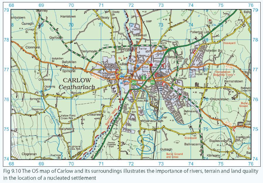
13 OS question on settlement With reference to the OS Map, what evidence do we have that New Stone Age settlers lived in the Boyne Valley?

14


15 The Celts In 800 BC the Celts came to Ireland. They brought iron age implements and built defensive settlements in Ireland. They built hill forts on elevated sites, promontory forts on small headlands and Cranogs on small islands in lakes. They brought the Irish language to Ireland, this is evidenced by place names we use today. Eg Dun = fort (Dun Aengus) Inis = Island (Inismore)
16 Needs of the early settlers The need for water A constant clean water supply was needed for drinking, washing and cooking. They chose the following sites for settlement; eg. Near lakes such as Lough Gur in Limerick..
17 The need for food The first settlers were hunters, gatherers and fisherfolk. They settled near water (for fishing) and woodland (for hunting and berry gathering). The first farmers planted crops and vegetables and they also reared animals. They settled in upland areas where the soil was well-drained and fertile. They also settled in river valleys (alluvial soil)
18 The need for defence Elevated (high) sites particularly hilltops were chosen for defence. The earliest known defensive settlement in Ireland is Lough Gur in Limerick (4000 BC) It was built on an island. It was built on a hilltop. The houses and enclosed area were surrounded by a bank of stone or earth. Huge stone spikes were placed in front of the fort.
19 The need for communications As Ireland was densely forested, water routes were the most accessible forms of transport. Rivers and lakeside settlements provide an easy, safe method of transport. Journeys were often made by canoe. Settlements were located near lakes such as Lough Gur in Limerick. By 300 BC the Iron-age was well established in Ireland with stone tools being replaced with iron ones. Much forest cover was moved and a network of tracks was established. Oak timbers were laid down over bogland over the midlands, these were called Toghers. In the midlands people travelled along eskers
20 Nucleated settlements in Ireland Social and historical - Past patterns and processes - Primacy of Dublin Resources and terrain - Altitude - Drainage patterns - Land quality
21 Social and historical factors Over time different settlers came from different places into Ireland. Their settlements grew into towns over time. Each wave of settlers had different reasons for their choice of location
22 Viking Settlements The Vikings came to Ireland around 800AD. They came in boats from Scandinavia. They settled along the coastline at river estuaries. Can you name any places where they settled? Why did they settle in these places?

23 Viking Settlements Many Viking settlements developed along the coast and on river estuaries. Many of the place names end in ford which comes from the Scandinavian word fjord.
24 Monastic Settlements Monasteries were built by monks after St. Patrick brought Christianity to Ireland. These monasteries were built in remote places like Glendalough. Other monks came to Ireland later, such as the Franciscans. They came in the 1100 s and set up many monasteries. These helped the towns to grow. Can you name any towns that grew around monastic sites? What evidence do we have today that monasteries were built in Ireland?
25 Norman Settlements The Normans invaded Ireland in the 12 th Century. Interested in fertile land They built great castles, often along the banks of rivers so they could defend themselves. They settled mainly in the south and east of Ireland. Can you name any towns that started as Norman settlements?
26 Norman Settlements Trim Kilkenny Carrigfergus Athenry Dublin

27 Plantation Towns The Ulster Plantation In the 16 th and 17 th centuries the British people came to Ireland to set up towns. Parts of Ireland were planted or settled by people loyal to the Queen of England. These are known as plantation towns. Examples in Ulster can be seen in Fig Other Plantation towns are Portarlington, Portlaoise, Youghal, and Mallow.
28 Landlord Towns After the plantations, many landlords built towns on the lands they had been given. They built spacious, well planned towns with fine architectural buildings. They had straight streets, town squares and English architecture. Examples include Abbeyleix, Birr, Kilrush, and Strokestown.

29 Modern Settlement If we examine OS Maps of Ireland today we find 3 different types of settlement. Linear: A line of houses along a road. Nucleated: A bunch of houses grouped together. Dispersed: Houses spread apart from each other.

30 The Primacy of Dublin Dublin is a primate city. A primate city is a city that is twice as big as the second biggest city in the same country. For example, Dublin is twice as big as Cork, so it is a primate city. Can you name any other primate cities in the other Countries?
. 4. It is Ireland s most important educational, cultural, and commercial centre. It is the centre for shopping and tourism too. 5.")
31 Why did Dublin become a Primate City? 1. Dublin is where the government of Ireland sits. 2. It is Ireland s main port, largest airport and thousands of employees. 3. It is Ireland s main transport focus. (Air, Sea, Rail, Roads). 4. It is Ireland s most important educational, cultural, and commercial centre. It is the centre for shopping and tourism too. 5. Ireland s most important financial centre, banks and HQs Dublin is therefore a zone of attraction for migrants, and foreign direct investment.


32 Dublin A Route Focus in Ireland All of the transport routes in Ireland focus on Dublin.
33 Dublin Centralisation Dublin is multi-functional and rapidly growing. During the celtic tiger years many MNC s moved there 28% of the population live there. Decentralisation The government tried to stop Dublin s rapid growth by decentrailisation. They relocated government offices. The project was halted in 2008 due to the downturn.
34 The Influence of Resources & Terrain on Settlement The following factors influence where towns and villages develop. 1. Altitude Little settlement occurs in upland areas. They are too cold, wet, and windy. It is also too difficult to build in the mountains. 2. Rivers Rivers attract settlement. In the past they were important for water, transport, and food. Fertile soil is also found alongside many rivers which is good for farming. Many towns also developed at bridge points. Ath in a town name indicates a crossing point. The largest urban centres in Ireland are located on river mouths or estuaries. Eg Dublin, Cork, Limerick and Waterford. 3. Land Quality Fertile land attracts settlement. This is why more people settled in the south and east of Ireland. The land is less fertile in the west. Marshy, infertile, flood land repels settlement. Towns in rich agricultural land thrived. Coastal settlements often attracted a fishing or tourist function so settlements grew. Marshlands often had settlements grow around the peat industry..

35 Coastal Settlements Ireland has many coastal towns and villages. They developed around the ports as fishing villages such as Killybegs. Other towns developed around beaches such as Tramore and Bundoran. With reference to the OS Map explain 2 reasons why Dunmore East developed in this location.

36 Coastal Settlements
37 With reference to the OS Map of Caher, explain in detail 3 reasons why the town of Caher developed at this place

38

39
40
41 Settlement in the Netherlands - Polders The Netherlands is a small country with a population of 16 million people. It has the highest population density in Western Europe (395 per km2) The people have reclaimed areas of land from the sea. This new land is called a Polder. Polders have given new farmland and space to live. How were the polders created? 1. A large dam was built across the mouth of a large coastal inlet. 2. Water was pumped out of the inlet, making it dry land. 3. Roads were built and farms were laid out on the land. 4. People moved onto the land.

42
43 How? A barrier dam enclosed lake Ijssel. Salt water was pumped out. New polders were created by building dykes of mud and stone. Roads were laid out, drainage channels excavated and pumps controlled water levels. Roads, farms and villages were planned.

44 Settlement Patterns on the Polders Settlement on the polders is in a planned radial pattern. A large town was built in the centre of the polder. It provides all the services needed for the population who live there. Smaller villages were built in a radial pattern around the main town.

45 The Polders as Overspill Zones The polders have acted as overspill zones for many people who lived in the large cities like Amsterdam and Rotterdam. People have moved from these cities and settled on the Eastern and southern polders in cities such as Lelystad and Almere.
46 The Functions of Nucleated Settlements Nucleated settlements (towns and villages) provide many different functions to the people who live there. Settlement type Function Village Market Defensive Resource based Port Residential Recreational Ecclesiastical Small range of services, groceries, petrol, church, school. More services, banking, supermarket, clothes shops Began on easily defended sites. Castle or ruins remain. Town develops around a coal mine, or other mineral mine. Town developed at a port or docks. People live there but travel to nearby city to work each day. Town developed around beach or other leisure facility. A religious function, caters for people s spiritual needs.
47 Settlement in a River Basin The Shannon Many towns have developed along the course of the River Shannon. These towns developed for many different reasons. For e.g. Foynes is a port settlement. Athlone started as a defensive settlement. Clonmacnoise started as an Ecclesiastical settlement. Killaloe has a leisure function for boating activities in Lough Derg.

48

49
50 Different Functions of Limerick City Limerick began as a defensive settlement. The Vikings settled in Limerick. The Normans settled there later and built King John s Castle. Limerick later developed into a market town. It grew as a bridge point of the River Shannon. It became a route focus. Limerick s port also helped the town to grow as a market town. Limerick has many functions today. It has an important residential function with many suburbs around the city centre. It also has an important educational function with 3 third level colleges.

51

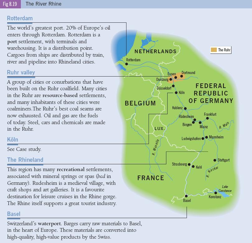
52 Settlement in a River Basin The Rhine The River Rhine is one of the busiest and most important rivers in Europe. It is used to transport huge amounts of goods into Europe. Many large towns and cities have developed along the course of the Rhine.
53
54 Koln (Cologne) Change over time Market function: As one of the most important bridge points on the Rhine, the city is a major route focus for road and rail routes. It s a modern market centre with shopping and business functions. Port function: One of the Rhine s most important inland ports. River cruises, barges and ocean going vessels all use these waters. Recreational function: Beautiful city with Belfries, Cathedral spires and bridges. It has interesting medieval architecture. The streets near the main cathedral are lined with bookshops, art galleries, coffee shops and boutiques.

55 Change in Function Over Time - Navan

56 Change in Function Over Time - Navan
57 Change in Function Over Time - Navan Settlements may change their function over time. Navan first developed as a market settlement. It was an important manufacturing town with furniture and carpet manufacturers in the past. In the 1970 s Navan also became a resource-based settlement when the largest lead and zinc mine in Europe was opened there. This brought new wealth and jobs to the area. The population increased as a result. It employed 670 people in Navan has also developed a residential function. Many people who work in Dublin live in Navan. They commute to Dublin each day to work. It is a dormitory town.

58 Population Increase in Navan

59
60 Large Scale Industrial Development - Clarecastle Clarecastle in Co. Clare is another example of a town whose function has changed over time. It began as a bridging point over the River Fergus. The Normans built a castle there in the 13 th century so the town had a defensive function. It also had a port function in the 19 th century as ships unloaded grain for Ennis. In the 1970 s a large chemical factory opened in the town. This factory brought new jobs to the area and money to the local economy. Clarecastle s main function today is a manufacturing function, the pharmaceutical plant Roche is located there. It is a dormitory town for workers in Shannon and Limerick.

61 Large Scale Industrial Development - Clarecastle

62

63

64 Irish road networks Laid out when Ireland was a British colony. Dublin became the main port for the export of raw materials. The road network is radial from Dublin.
65 Roads aid the development of settlements Manufacturing towns and industrial estates need good access for trucks. Shannon and it s industrial estates are served by the N18 and N19. Market towns grow with access to their hinterlands (shopping and services). Dormitory towns grow. Naas, Navan, Drogheda, Wicklow commuter towns connected by motorway. Urban centres at crossing points become an important route focus, this increases traffic to urban centres and helps them develop. Tourist towns need good road access.
, Schiphol, Paris, Barcelona and Frankfurt.")
66 EU airports Air routes link urban centres. They improve accessibility. Air transport is popular today because; The population of western Europe is wealthy. Low cost airlines and competitive prices have greatly reduced air fares. Examples: Heathrow (70+ million per year), Schiphol, Paris, Barcelona and Frankfurt.

67 Airports serving London Heathrow Stansted Gatwick London city Luton

68 Shannon airport Shannon airport is very important to nearby urban centres. Many people living and working in the airport live in nearby dormitory towns. In 1962 Shannon new town was developed, many airport workers live here.

69 Transport on the Rhine Many large urban centres are located on the banks of the river Rhine. It s navigable river reaching through Europe to Switzerland. Rotterdam Europort is one of the world s largest ports. It imports crude oil, metal ores, timbers and chemical raw materials

70 Manufacturing cities The Rhine waterway has aided the growth of manufacturing cities on it s banks. The Rhine gives industries access to raw materials. Heavy industries are located in Duisburg and Koln. Barges also travel on the Rhine s tributaries. Tourists travel on cruise on the Rhine
The First Settlers in Ireland
 Settlement Settlement Timeline 1. The Hunter-Gatherers of Mount Sandel 2. The New Stone Age Settlers 3. Early Christian Monastic Settlements 4. The Vikings 5. The Normans 6. Later Monastic Settlements
Economy 3. This region s economy was based on agriculture. 4. This region produced items such as textiles, iron, and ships in great quantities. For th
 Geography 1. This region has a climate of warm summers and snowy cold winters. 2. This region has a climate that is generally warm and sunny, with long, hot, humid summers, and mild winters, and heavy
MCGRAW-HILL EUROPE. Chapter 11 Physical Geography Pages 332 to 341
 MCGRAW-HILL EUROPE Chapter 11 Physical Geography Pages 332 to 341 Countries of Western Europe Benelux Countries UK, France, Luxembourg, Germany, Netherlands, Belgium, Austria, Switzerland, Belgium, Monaco,
Chapter 5 Test British Isles 1
 Name Score Chapter 5 Test British Isles Part 1 Labeling (28 pts.) A. (9pts.) Locate the countries and other major political features contained in the word box below on the map of the British Isles on the
LOCATION, CLIMATE, AND NATURAL RESOURCES OF MEXICO
 SS6G3 The student will explain the impact of location, climate, distribution of natural resources, and population distribution on Latin America and the Caribbean. a. Compare how the location, climate,
Physical Geography of Europe. Chapters 13-18
 Physical Geography of Europe Chapters 13-18 The British Isles Archipelago made of 6000+ small islands Temperate climate Largest body of fresh water is Loch Ness Mostly rolling hills and large flat lands
Tertiary Economic Activity. Providing services for people.
 Tertiary Economic Activity Providing services for people. Tertiary Economic Activities Tertiary economic activity involves providing services for people. In wealthy countries there are lots of people employed
Chapter 7 Geography and the Early Settlement of Egypt, Kush, and Canaan
 Chapter 7 Geography and the Early Settlement of Egypt, Kush, and Canaan How did geography affect early settlement in Egypt, Kush, and Canaan? Section 7.1 - Introduction RF/NASA//Corbis This satellite photograph
Chapter 25 Geography and the Settlement of Greece. How did geography influence settlement and way of life in ancient Greece?
 Chapter 25 Geography and the Settlement of Greece 25.1 Introduction How did geography influence settlement and way of life in ancient Greece? Tal Naveh/Shutterstock The ancient Greeks learned to use the
Location, Climate, & Natural Resources Brain Wrinkles
 Location, Climate, & Natural Resources Standards SS6G10 The student will explain the impact of location, climate, natural resources, and population distribution on Europe. a. Compare how the location,
Brazil. Chapter 12. Chapter 12, Section
 Chapter 12, Section World Geography Chapter 12 Brazil Copyright 2003 by Pearson Education, Inc., publishing as Prentice Hall, Upper Saddle River, NJ. All rights reserved. Chapter 12, Section World Geography
SAMPLE ITINERARY IRELAND PERFORMANCE TOUR (itinerary subject to change)
") SAMPLE ITINERARY IRELAND PERFORMANCE TOUR (itinerary subject to change) DAY ONE: DUBLIN ARRIVAL LIMERICK (D) Arrive into Dublin, Ireland! Collect your luggage and move through customs and immigration.
SAMPLE ITINERARY IRELAND PERFORMANCE TOUR (itinerary subject to change) DAY ONE: DUBLIN ARRIVAL LIMERICK (D) Arrive into Dublin, Ireland! Collect your luggage and move through customs and immigration.
Ireland and Northern Ireland
 Dr. Wheeler Style Tour with Robert Byrd to Ireland and Northern Ireland Saturday, June 23, 2018, to Saturday, July 7, 2018 The Isle of Ireland, located on the Western rim of Europe, is perhaps the most
GEOGRAPHY OF UK. (O Driscoll, James. 2003)
") GEOGRAPHY OF UK (O Driscoll, James. 2003) A group of about 5,000 islands off the northcoast of mainland Europe Between the latitude 50 N and 61 N UK consists of four countries; * England, * Wales, * Scotland,
GEOGRAPHY OF UK (O Driscoll, James. 2003) A group of about 5,000 islands off the northcoast of mainland Europe Between the latitude 50 N and 61 N UK consists of four countries; * England, * Wales, * Scotland,
60 Minutes 45 Minutes
 Our central location Our central location Laois s connectivity ensures quick access to key airports and ports across Ireland, while also delivering a large customer base and skilled workforce to its door.
North Africa. Chapter 25. Chapter 25, Section
 Chapter 25, Section World Geography Chapter 25 North Africa Copyright 2003 by Pearson Education, Inc., publishing as Prentice Hall, Upper Saddle River, NJ. All rights reserved. Chapter 25, Section World
Chapter 7. Geography and the Early Settlement of Egypt, Kush, and Canaan
 Chapter 7 Geography and the Early Settlement of Egypt, Kush, and Canaan Chapter 7 Geography and the Early Settlement of Egypt, Kush, and Canaan How did geography affect early in Egypt Kush, and Canaan?
Ancient Egypt and the Near East
 *O*»f ' i ft Ancient Egypt and the Near East Chapter 7 Chapter 8 Chapter 9 Geography and the Early Settlement of Egypt, Kush, and Canaan The Ancient Egyptian P h a r a o h s Daily Life in Ancient Egypt
Location, Climate, & Natural Resources
 Location, Climate, & Natural Resources UK is a country of islands off the coast of mainland Europe. It consists of England, Northern Ireland, Scotland, & Wales. UK s location makes it a HUB for trade.
Chapter 7: The Geography and Settlement of Egypt, Kush, and Canaan
 Chapter 7: The Geography and Settlement of Egypt, Kush, and Canaan Learning Target: I can explain how geography affected early settlement in Egypt, Kush, and Canaan. Ancient Egypt and the Middle East Can
Australian Geography. Standards:
 Australian Geography Standards: SS6G12 The student will be able to locate selected features of Australia. a. Locate on a world and regional political-physical map: the Great Barrier Reef, Coral Sea, Ayers
Chapter 17. North Africa, Southwest Asia and Central Asia
 Chapter 17 North Africa, Southwest Asia and Central Asia Chapter Objectives Describe the major landforms and natural resources of North Africa, Southwest Asia, and Central Asia. Discuss the climate and
Effect of Geography on Ancient Greece. Chapter 4-1
 Effect of Geography on Ancient Greece Chapter 4-1 Greek Geography Greece is a peninsula that is covered by many mountains. Geography Continued. It is located in the heart of the Mediterranean Sea. The
4th Grade Social Studies 2nd Nine Weeks Test
 4th Grade Social Studies 2nd Nine Weeks Test Multiple Choice Identify the choice that best completes the statement or answers the question. 1 Which is the largest city in the United States? A Philadelphia,
GALWAY BAY, CONNEMARA & MAYO UNSPOILT IRELAND NIGHTS/8 DAYS, - GUIDED OR SELF GUILDED
 GALWAY BAY, CONNEMARA & MAYO UNSPOILT IRELAND 2018 7 NIGHTS/8 DAYS, 265kms - GUIDED OR SELF GUILDED Your cycling adventure starts and finishes in the cobbled streets of one of Ireland s loveliest, liveliest
Chapter Objectives. Describe the dominant landforms and natural resources of Southeast Asia. Discuss Southeast Asia s climate and vegetation.
 Chapter Objectives Describe the dominant landforms and natural resources of Southeast Asia. Discuss Southeast Asia s climate and vegetation. The Land Section 1 Objectives Describe how tectonic plates and
Rivers. Highlights of some of the World s Most Famous Rivers!
 Rivers Highlights of some of the World s Most Famous Rivers! Directions This Power Point presentation contains information about some of the most famous rivers in the world! Students should use this presentation
GALWAY BAY, CONNEMARA & MAYO UNSPOILT IRELAND NIGHTS/8 DAYS, - GUIDED OR SELF GUILDED
 GALWAY BAY, CONNEMARA & MAYO UNSPOILT IRELAND 2019 7 NIGHTS/8 DAYS, 265kms - GUIDED OR SELF GUILDED Your cycling adventure starts and finishes in the cobbled streets of one of Ireland s loveliest, liveliest
Unit 9 The Middle East SG 1 - Physical Geography, Population & Demographics
 Unit 9 The Middle East SG 1 - Physical Geography, Population & Demographics I. Physical Geography A. The Middle East includes southwestern Asia and North Africa. 1. The name is Eurocentric. Middle East
Europe. World Geography
 Europe World Geography Physical Geography Europe s landforms also include large plains and mountain ranges. Europe is composed of many peninsulas and islands. Always near Water Europe is a large peninsula
Label your Map with Russia. Map Activity
 Bell Activity How many time zones does the U.S. have? How do these time zones affect life in the U.S.? Russia is so large it has 11 time zones. What difficulties might this create? Objectives Know landforms,
Ireland Tour. University of Illinois Marching Illini. Trip Highlights. Professor Barry Houser, Director
 University of Illinois Marching Illini Professor Barry Houser, Director Ireland Tour Trip Highlights Visit Dublin, Galway, Belfast Downtown Dublin Hotel Full Irish Breakfast Dinner each night Tour of Kilkenny
Come join this 10 day tour of Ireland August 28 September 7, 2018 With Mike Byrne
 Discover extraordinary places, fun-filled moments and treasured dreams. Transform your dreams into an exciting new journey in 2018. Come join this 10 day tour of Ireland August 28 September 7, 2018 With
Latin America 11/4/2013. Latin America Today. 580 million people 9% of the world s population Diverse backgrounds:
 Latin America Chapter 10 Human Geography Latin America Today 580 million people 9% of the world s population Diverse backgrounds: Native Americans Europeans Africans Asians 1 Population 393 million live
Land Distribution. Land Purchases. 14 The Nature of Settlement: Post-Revolution to the Civil War Changing Shape of New York
 14 The Nature of Settlement: Post-Revolution to the Civil War 1780-1865 Prof. Anthony Grande Geography Dept. Hunter College-CUNY Spring 2018 Settlement Sequence: State of New York Revolutionary War ends
TRIP ITINERARY may 12 21, 2019
 TRIP ITINERARY may 12 21, 2019 Ireland may 12 18 accommodation For 6 nights we will stay at the beautiful Adare Manor, located in the rolling countryside on the outskirts of Limerick, Ireland. The manor
University of Illinois Marching Illini
 University of Illinois Marching Illini Professor Barry Houser, Director Iead o Trip Highlights Visit Dublin, Galway, Belfast Guided tour of each city Downtown Dublin Hotel March in St. Patrick s Day Parade
Spanish Missions History and Purpose
 Spanish Missions History and Purpose Columbus's voyage of discovery opened a new world of possibilities for the Spanish. In the Americas, Spain soon began to use its soldiers to increase the size of its
Chapter 20. The Physical Geography of Africa South of the Sahara
 Chapter 20 The Physical Geography of Africa South of the Sahara Chapter Objectives Identify the major landforms, water systems, and natural resources of Africa south of the Sahara. Describe the relationship
Chapter 4. Daily Focus Skills
 Chapter 4 Daily Focus Skills Chapter 4 On a historical map of the ancient Mediterranean area, locate Greece and trace the boundaries of its influence to 300 BC/BCE. Explain how the geographical location
SIXTH GRADE SCHOOL TOURS AT THE HACKETT HOUSE - CARLOW, IRELAND
 SIXTH GRADE SCHOOL TOURS AT THE HACKETT HOUSE - CARLOW, IRELAND The presentation will cover timelines and historical information as it fits: Performance Objectives covered: Construct timelines of the historical
O Brien Clan Foundation Pilgrimage 2019
 O Brien Clan Foundation Pilgrimage 2019 There will be the option of a two day pre-tour in Dublin before the start of the tour as well as a post-tour stay at Dromoland Castle which will include accommodation
Ireland June 6-14, 2017
 Ireland June 6-14, 2017 Book by 30 January and Save $170 per person City Countryside Coastlines Castles QC Women s Travel Group Exclusive Small Group 9 Day fully escorted tour Departing from Moline Irish
Chapter 25 Section One: Istanbul: A Primate City throughout History urban primate city
 Chapter 25 Section One: Istanbul: A Primate City throughout History Meryem lives in Istanbul, the largest city in Turkey. It is early morning. She is riding a ferryboat to get to work. The ferry carries
THE BRITISH ISLES AND NORDIC NATIONS. Chapter 15
 THE BRITISH ISLES AND NORDIC NATIONS Chapter 15 A LITTLE CONFUSING. UK refers to the political union between the countries. -Sovereign state but nations are also individual countries. Great Britain is
IRELAND TOUR & SCRABBLE TOURNAMENT AUGUST 18-26, 2012
 IRELAND TOUR & SCRABBLE TOURNAMENT AUGUST 18-26, 2012 Day 1: Saturday, August 18: Individual arrivals in Dublin. Check in at the Shelbourne Hotel. A national treasure built in 1824, the Shelbourne Hotel
Reading Informational Medford 549C Work Sample Effective February 2010 Informational Text Title:
 Reading Informational Medford 549C Work Sample Effective February 2010 Informational Text Title: Geography and the Settlement of Greece Reading Work Sample Assessment Middle School Geography and the Settlement
Chapter 3 Section 4 The Phoenicians
 Chapter 3 Section 4 The Phoenicians The Phoenician People Phoenician civilization began along a thin strip of land along the Mediterranean coast. Fearless sailors who for hundreds of years dominated sea
Pendeen Ten Thousand Years of History
 Pendeen Ten Thousand Years of History Geevor On first sight, the village of Pendeen seems to be a product of 19 th century mining, it has in fact a long and complex history rich in archaeological and other
Tourism potential in Bangladesh. 26 th of march 2008
 Tourism potential in Bangladesh 26 th of march 2008 Majbritt Thomsen Education In Bangladesh Finding relevant work Danish Embassy B2B DANIDA, production sector Tourism potential report This lecture Share
area sq. km capital - Camberra situated on the southern hemisphere, surrounded by the Indian and Pacific ocean
 Otázka: Australia and New Zealand Jazyk: Angličtina Přidal(a): Petra The commonwealth of Australia area 7 700 000 sq. km capital - Camberra situated on the southern hemisphere, surrounded by the Indian
Chapter 11 Study Guide Western Europe
 Chapter 11 Study Guide Western Europe I. Northern Europe: Consists of and A. United Kingdom (Constitutional Monarchy and has political divisions) *, and make up the island known as Great Britain, while
Corlea Archaeological. Settlement and Biodiversity. Project.
 Corlea Archaeological Settlement and Biodiversity Project. Pic 1: Rehabilitated and re-colonised bog. September 2013 1 The Corlea Archaeological Settlement and Biodiversity Project. TABLE OF CONTENTS 1.
IPSWICH MEANS BUSINESS
 IPSWICH MEANS BUSINESS Ipswich is the oldest English town that boasts a new waterfront, a university and a cultural centre that attracts visitors from all over the world. Its location makes connection
Relative Location. originally in the today outdated today centered in population center closet to Channel Tunnel.
 NAME PERIOD LOCATION OF INDUSTRIAL REGIONS AROUND THE WORLD DIRECTIONS: Complete the following chart using Chapter 11 Key Issue # 1 in your textbook. Describe the relative location of each region and the
Sheffield Island Camden County, GA
 For Sale $3,150,000 Sheffield Island Camden County, GA 452.5 Total Acres 230 Estimated Upland Acres William Lattimore 912.596.7019 Overview A rare opportunity to own a portion of a pristine island off
Percentage Share Total Workers Main Workers 29.5 Marginal Workers 2.22 Non-Workers Source: Census of India, 2001.
 4.0 LOCAL ECONOMY 4.1 WORKFORCE Working population of Udaipur comprises about 32% of total population (UMC) of city, of this 93% population constitutes main workers whereas rest 7% fall under marginal
Rivers of the World. The Nile. The Rhine
 The Nile The Nile is traditionally considered to be the longest river in the world. It is 4132 miles (6650 km) long that s nearly seven times the distance from John o Groats at the top of Scotland to Land
The Geological Pacific Northwest. Wednesday February 6, 2012 Pacific Northwest History Mr. Rice
 The Geological Pacific Northwest Wednesday February 6, 2012 Pacific Northwest History Mr. Rice 1 Free Response #2 Please do not simply list the items for this response. Full sentences!!! Minimum of 3-5
Ancient Egypt. Land of the Pharaohs
 Ancient Egypt Land of the Pharaohs CHAPTER 4 EGYPT SECTION 1: GEOGRAPHY AND EARLY EGYPT BIG IDEA The water, fertile soils, and protected setting of the Nile Valley allowed a great civilization to arise
Wednesday, January 16, Celts and Mythology
 Celts and Mythology Ice-age geography Ice-age geography What happened to Ireland in the last ice-age? Ice-age geography What happened to Ireland in the last ice-age? c. 125,000-15,000 years ago Ice-age
IRELAND: AN ARCHEOLOGICAL JOURNEY JUNE 30-JULY 6, 2018
 IRELAND: AN ARCHEOLOGICAL JOURNEY JUNE 30-JULY 6, 2018 DAY 1 DAY 2 DUBLIN Our tour officially begins in your hotel at 12 p.m., when you are greeted by your tour guides, Stephen Mandal and Lisanne O Loughlin.
CH. 1 Europe and Russia: Physical Geography. Section 1 Land and Water p Europe and Russia are part of the world s largest landmass called.
 CH. 1 Europe and Russia: Physical Geography Section 1 Land and Water p.10-16 Europe and Russia are part of the world s largest landmass called. The country of Russia stretches over both continents. About
GEOGRAPHY AND HISTORY
 GEOGRAPHY AND HISTORY YEAR 1, PART 1 www.vicensvives.es Contents 01 Our planet Earth 02 The representation of the Earth: maps 03 The Earth s relief 04 Rivers and seas 05 Weather and climate 06 Climates
Culture of the Netherlands Presented by Dual Wu Director Netherlands Education Support Office Taipei
 Culture of the Netherlands Presented by Dual Wu Director Netherlands Education Support Office Taipei Geography The country is situated in the west of Europe and borders Germany to the east, Belgium to
Crabtree Publishing Company
 By Gary Miller Company www.crabtreebooks.com Author: Gary Miller Editor: Barbara Bakowski Designer: Tammy West, Westgraphix LLC Photo Researcher: Edward A. Thomas Map Illustrator: Stefan Chabluk Indexer:
Location, Climate, & Natural Resources. Where People Live & How They Trade
 Location, Climate, & Natural Resources Where People Live & How They Trade Standards SS6G13 The student will explain the impact of location, climate, distribution of natural resources, and population distribution
Introduction to Africa
 Introduction to Africa Did you know? Africa has more countries than any other continent. The Sahara is a desert that is the size of the U.S. It s the world's largest desert. Most of the world s gold and
SOL VS.2a, 2b, 2c, 10b
 What are the characteristics of the Coastal Plain? 1. Also known as Tidewater 2. Located near the Atlantic Ocean and the Chesapeake Bay 3. Includes the Eastern Shore, a peninsula between the Atlantic Ocean
6 DAY ANCIENT IRELAND TOUR SAMPLE ITINERARY
 IMPORTANT: Please note that this itinerary is a framework for the tour. This means that: 6 DAY ANCIENT IRELAND TOUR SAMPLE ITINERARY 1. The overnights are pretty much set in stone and then we base each
Physical characteristics and biomes:
 Physical characteristics and biomes: Sahel region, bordering Sahara Characteristics Area suffers from lack of rainfall, over grazing, which causes loss of vegetation and loss of inhabitable areas causing
Countries Of The World: Spain
 Countries Of The World: Spain By National Geographic Kids, adapted by Newsela staff on 04.25.18 Word Count 677 Level 830L Image 1. The Puento Nuevo in Ronda, Spain. The bridge was built in the late 1700s
ADMISSIONS: I have NOT included any site admissions as you may wish to choose which ones you wish to enter and take the guided tour.
 Outline Itinerary for Mary O Connor and Ellen Smith A Private Tour - 8 day itinerary Detailed 35 page itinerary will be included with the final documents. SPECIAL NOTE: The sites that are mentioned in
Itinerary Prepared : Four Day Ireland Tour Date Itinerary Reference. March 09, 2009 ICTS : : Details Your Itinerary runs from
 Itinerary Prepared : Four Day Ireland Tour Date Itinerary Reference : : Details Your Itinerary runs from March 09, 2009 ICTS000756 04 Jul 2009 to 07 Jul 2009 for 4 Adults. Includes * Chauffeur Drive: 4
You Will Need: Your notebook Your textbook Your pencil
 You Will Need: Your notebook Your textbook Your pencil Today you will learn about the kingdoms of Kush and Aksum who developed advanced civilizations with large trading networks. Kush and Aksum Kush and
ENVIRONMENTAL SYSTEMS LESSONS High School level DRAFT
 ENVIRONMENTAL SYSTEMS LESSONS High School level DRAFT Project: Data Sets and Inquiry in Geoscience Environmental Restoration Studies (NSF GEO- 0808076) Authors: Daniel Zalles, Center for Technology in
STANDARDS: Brain Wrinkles
 STANDARDS: SS6G3 The student will explain the impact of location, climate, distribution of natural resources, and population distribution on Latin America and the Caribbean. a. Compare how the location,
Tulach Nore. Pike of Rushall, Portlaoise, Co. Laois, R32 TK54 BER
 Tulach Nore Pike of Rushall, Portlaoise, Co. Laois, R32 TK54 BER Tulach Nore, Pike of Rushall, Portlaoise, Co. Laois. A wonderful private estate with a delightful two storey Victorian property and extensive
Friday, November 10, 2017
 Friday, November 10, 2017 Andes and Midlatitude Countries Objective: Summarize the main physical features and regions of the Southern Cone. Identify and locate the urban centers and understand the pattern
CHAPTER 12. South America. Section 1: Natural Environments Section 2: History and Culture Section 3: South America Today. HOLT World Geography
 CHAPTER 12 South America Section 1: Natural Environments Section 2: History and Culture Section 3: South America 1 Section 1 Natural Environments Objectives: What are the major landforms and rivers of
With only about 330,000 people in a country roughly the size of Kentucky the human impact is still surprisingly vast. Across the countryside farms
 Iceland is located in the North Atlantic Ocean, between Scotland and Greenland. Although only a small tip of the island of Grimsey is actually located above the Arctic Circle, most of the island s biological
Economic Sectors. The region is home to what many consider to be one of the most valuable timber supplies in the Province.
 Sectors Economic Sectors With Powell River s strategic location it is no wonder the area is blessed with many successful industries and sectors. The strength of Powell River s economic condition comes
Egypt and the Nile River Valley System. SC Standards 6-1.3, 1.4, 1.5
 Egypt and the Nile River Valley System SC Standards 6-1.3, 1.4, 1.5 Where is Egypt? Egypt is on the continent of Africa. The River Nile runs through Egypt The capital of Egypt is Cairo Where is Egypt?
Brazil. Population & Culture
 Brazil Population & Culture Population of Brazil Largest country in South America 200 million people (2012 est) Growing population - approximately 1% per year Life expectancy - approx 72 years Population
ENGLISH COLONIES CHAPTER 3
 ENGLISH COLONIES CHAPTER 3 NEW ENGLAND COLONIES Colonies MA PLYMOUTH, MA BAY, NH, CT, RI Climate/Geography bitterly cold winters and mild summers; SHORT GROWING SEASONS! Land was flat close to the coastline
3 Archaeological Landscapes
 3 Archaeological Landscapes Pg 9-26 3. Archaeological Landscapes 1.Tiduff/Glenderry (Kerry Head) Promontory Forts, Hillfort/Hilltop Enclosure, Linear Earthwork (Red Ditch). The monuments located in this
Tallinn Capital of Estonia with its The Fairy-Tale Charm. Dr. Tom Duryea
 Tallinn Capital of Estonia with its The Fairy-Tale Charm Dr. Tom Duryea Copyright 2016 Prehistoric Early Middle Ages High Middle Ages Danish Influence Brotherhood of the Swords & The Teutonic Knights The
Warm ups *What is unique about the status of Switzerland? *How Austria s history differed from that of Switzerland?
 Warm ups 12.07.2016 *What is unique about the status of Switzerland? *How Austria s history differed from that of Switzerland? Lesson Objective: *describe how Spain differs physically, economically, and
Waterways Ireland. Largest of the six North/South Implementation Bodies
 Waterways Ireland Largest of the six North/South Implementation Bodies Statutory Function Manage, Maintain, Develop and Promote the Inland Navigable Waterways principally for Recreational Purposes 1,000
Latin America and The Caribbean. A Closer Look.
 Latin America and The Caribbean A Closer Look. Mexico Capital: Mexico City The Location of Mexico Mexico is the second-largest country by size and population in Latin America.but the Largest Spanish -
Lesson 1: Land and Climate of the West Land and Water of the West 1. There are 13 states in the West, divided into 3 regions a. Southwest: Nevada,
 Lesson 1: Land and Climate of the West Land and Water of the West 1. There are 13 states in the West, divided into 3 regions a. Southwest: Nevada, Utah, Arizona, New Mexico b. Mountain States: Wyoming,
National Library of Ireland Microfilms for Sale (March 2014)
") National Library of Ireland Microfilms for Sale () Title Year Published No. of Amárach 1956-1976; Jan - May 1977; Sep - 1982 Argus (Drogheda) 1936; 1943 47 Argus (Monaghan) 14 th August 1954 1959 Athlone
National Library of Ireland Microfilms for Sale () Title Year Published No. of Amárach 1956-1976; Jan - May 1977; Sep - 1982 Argus (Drogheda) 1936; 1943 47 Argus (Monaghan) 14 th August 1954 1959 Athlone
Countries Of The World: France
 Countries Of The World: France By National Geographic Kids, adapted by Newsela staff on 03.26.18 Word Count 681 Level 780L Image 1: A view of the Eiffel Tower in Paris, France. Paris, or, "the city of lights,"
early human history and Central & South America Jeopardy
 early human history and Central & South America Jeopardy Every team will be chosen by Joe with the intention of mixing girls and boys and grade levels. Teams can choose a name if desired. teams can answer
The Tacoma Star of Destiny
 The Tacoma Star of Destiny The Tacoma Star of Destiny is an advertising tool that was developed early in the 20th century touting all the advantages of Tacoma, WA. The following is the list of the manufacturers,
Brain Wrinkles. Location, Climate, & Natural Resources of. Where People Live & How They Trade
 Location, Climate, & Natural Resources of Where People Live & How They Trade It s south of the US, east of the Pacific Ocean, and west of the Gulf of Mexico & Caribbean Sea. It s great that it s located
3 x Dinners, breakfast daily. English speaking local Guides. Transfers as shown. Entrance to Waterford Factory. Water on vehicles
 Ireland A small country with a big reputation, helped along by an ancient landscape and friendly people, whose lyrical nature is expressed in the warmth of their welcome. Ireland Dublin is the capital
6 DAY NORTHERN ISLAND TOUR SAMPLE ITINERARY
 IMPORTANT: Please note that this itinerary is a framework for the tour. This means that: 6 DAY NORTHERN ISLAND TOUR SAMPLE ITINERARY 1. The overnights are pretty much set in stone and then we base each
County Wicklow 94. Powerscourt Estate Glendalough Enniskerry Blessington Rathdrum
 4 PLAN YOUR TRIP CONTENTS Contents Plan Your Trip Ireland s Top 12... 6 Itineraries...18 If You Like... 24 Month by Month... 26 Get Inspired... 29 Family Travel...30 Need to Know... 32 Dublin 34 Trinity
Terms to Know. artesian well coral atoll krill lagoon
 Chapter Objectives Describe the diverse landforms and natural resources of Australia, Oceania, and Antarctica. Discuss the wide range of climates and vegetation throughout the region. The Land Section