FIELD SURVEYS FOR HEXALECTRIS COLEMANII IN SOUTHEASTERN ARIZONA MAY JUNE 2010
|
|
|
- Godfrey Campbell
- 5 years ago
- Views:
Transcription

1 FIELD SURVEYS FOR HEXALECTRIS COLEMANII IN SOUTHEASTERN ARIZONA MAY JUNE 2010 Prepared for: ROSEMONT COPPER COMPANY 3931 W Ina Road Tucson, Arizona Prepared by: 4001 East Paradise Falls Drive Tucson, Arizona JULY 28, 2010 Project No
2 WestLand Resources, Inc. Engineering and Environmental Consultants 4001 East Paradise Falls Drive Tucson, Arizona Ph: (520) Fx: (520) Date: July 29, 2010 WestLand File No.: Pickup Deliver X Mail By: v132,17 The Runner (Courier) (Client to Pickup, Name of Courier or In-house Delivery; FedEx with Type, LISPS Regular, LISPS Priority, or (ASPS Certified Mail; etc.) TO: Ms. Melissa Reichard SWCA Environmental Consultants TRANSMITTAL FOR YOUR: 343 W. Franklin Street Information Tucson, AZ Use X Signature FROM: Brian Lindenlaub Stamp Review RE: Rosemont Copper Project Approval File SENT: Per Your Request Other (see comments) As Requested By: ATTACHED: Copies Originals 2 1 Field Surveys for Hexalectris Colemanii in Southeastern Arizona, May-June 2010 Report prepared for Rosemont Copper Company CD containing above-referenced report Copies Originals Your Redlines Check Comments: CC: If Delivered or Picked Up: Received by (Signature/Print Name) Date
3 Field Surveys for Hexalectris colemanii in Southeastern Arizona July 28, 2010 May June 2010 Page ii TABLE OF CONTENTS Executive Summary...iv 1. Introduction Description of Survey Areas, Field Methods, and Materials Field Training Survey Approach in Rosemont Area Survey Approach Outside of Rosemont Area Survey Results Surveyors and Survey Effort Survey Results within the Rosemont Area Survey Results Outside of the Rosemont Area Conclusions from 2010 Survey for H. colemanii References Cited...16 Table 1. Table 2. Table 3. Table 4. LIST OF TABLES All areas surveyed during the 2010 Hexalectris colemanii inventory with specific reference to canyon, mountain range, and surveyor... 7 Rosemont area surveyed Hexalectris colemanii inventory by WestLand. Survey conducted May 18-June 28 and June 7-9, UTM Coordinates of the historic locations of Hexalectris colemanii in McCleary Canyon, Santa Rita Mountains, in NAD Canyons surveyed outside Rosemont area Hexalectris inventory by WestLand, Holly Lawson, and other volunteers LIST OF FIGURES (All figures follow text) Figure 1. Vicinity Map Figure 2. Regional Map of Historic Locations of Hexalectris colemanii Figure 3. Rosemont Area, 2010 Orchid Survey Figure 4. Detailed Survey Area, showing Hexalectris colemanii locations Figure 5. Detailed Survey Area, showing Hexalectris colemanii locations (Wasp Canyon, McCleary Canyon) Figure 6. Regional Map of Hexalectris surveys in 2010 Figure 7. Overview of survey area, Cochise Stronghold, West and East Canyons, Big Dragoon Mountains Figure 7a. Detailed Survey Area, Cochise Stronghold, West and East Canyons, Big Dragoon Mountains Figure 7b. Detailed Survey Area, Cochise Stronghold, West and East Canyons, Big Dragoon Mountains Figure 8. Canyons surveyed outside Rosemont Area Figure 9. Detailed survey area, Solano Canyon, Baboquivari Mountains Figure 10. Detailed survey area, upper Canada del Oro Canyon, Santa Catalina Mountains Figure 11. Detailed survey area, Sawmill Canyon, Santa Rita Mountains Figure 12. Detailed survey area, Box Canyon Figure 13. Detailed survey area, Florida Canyon Figure 14. Detailed survey area, Agua Caliente and Montosa Canyon Q\jobs\1000s\ \Orchids\July 28 Report\\Rosemont Hexalectris survey report 72810REV.doc WestLand Resources, Inc. Engineering and Environmental Consultants
4 Field Surveys for Hexalectris colemanii in Southeastern Arizona July 28, 2010 May June 2010 Page iii LIST OF APPENDICES Appendix A. Chronology of field notes and observations by Ronald A. Coleman Appendix B. Contributions by Holly Lawson, Rosemont Copper Reclamation Specialist Appendix C. GPS Data of Hexalectris located during surveys in May and June 2010 Q\jobs\1000s\ \Orchids\July 28 Report\\Rosemont Hexalectris survey report 72810REV.doc WestLand Resources, Inc. Engineering and Environmental Consultants
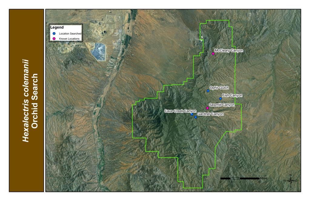
5 Field Surveys for Hexalectris colemanii in Southeastern Arizona July 28, 2010 May June 2010 Page iv EXECUTIVE SUMMARY The orchid, Hexalectris colemanii (Catling 2004, Kennedy and Watson 2010), is a non-photosynthetic, obligately mycotrophic orchid with a subterranean rhizome. The only visible portion of the plant is the inflorescence, detectable as the < 35 cm sprout emerges above ground to flower. The time frame in which the inflorescence can be seen is brief, mid-may to mid-june. Its brief appearance each year and its relatively inconspicuous inflorescences have contributed to its rather late first-detection, 1981, as an element of the Arizona flora. H. colemanii has previously been located in Baboquivari Canyon (Baboquivari Mountains), McCleary and Sawmill canyons (Santa Rita Mountains) and Cochise Stronghold West Canyon (Big Dragoon Mountains). Voucher specimens of this species have previously been collected in three of these canyons but not in Cochise Stronghold West Canyon. A single vouchered sighting in 1981 is the only evidence for its occurrence in Baboquivari Canyon. In 1986, McLaughlin made the first vouchered sighting of this species in McCleary Canyon. Coleman, as part of his ongoing research into the distribution of native orchid species in Arizona and New Mexico, began to monitor a population of this species in McCleary Canyon in The following year, he located the species for the first time in Sawmill Canyon and Cochise Stronghold West Canyon. Coleman was unable to relocate the orchid after two visits (1997 and 1998) to Baboquivari Canyon even with directions from Larry Toolin, who had made the 1981 collection. Coleman s monitoring and survey efforts from about 1997 to 2009 have produced only four known locations for H. colemanii. An indication of the number of known plants at each of the four locations is provided by Coleman s monitoring of inflorescences, with the maximum and minimum number of inflorescences seen over the years at each of the four sites: Baboquivari Canyon (1, only in 1981); McCleary Canyon (40 max, 0 min, during 13 years of monitoring), Sawmill Canyon (30 max, 0 min, during 13 years of monitoring), and Cochise Stronghold West Canyon (6 max, 0 min, during five years of monitoring) (Coleman 2010 in Appendix A). WestLand Resources was asked by Rosemont Copper Company to survey for Hexalectris colemanii on the entire Rosemont Area (all areas included in the Rosemont Mine Plan of Operations and the alternatives developed by the Coronado National Forest as part of their National Environmental Policy Act review of the Plan of Operations). These surveys were conducted during May and June, 2010, when inflorescences of this orchid sprout or are in flower. Survey efforts were focused on the portions of the Rosemont Area that have Arizona white oak (Quercus arizonica) and Emory oak (Quercus emoryi) stands with contiguous, closed or nearly closed canopies. While surveying the Rosemont Area, the surveyors also delineated the vegetation in the canyon bottoms and along the slopes according to the general species composition of the trees to facilitate complete survey coverage of suitable sites within the Rosemont Area that were identified based upon the described habitat preferences of this species. WestLand field biologists conducted a total of 115 person-days of field surveys in the Rosemont Area, 54 person-days of which were in the watershed of McCleary Canyon. The outcome of the 2010 surveys on the Rosemont Area was the detection of 124 inflorescences of H. colemanii in four distinct sites: 15 inflorescences in the historic 1 location in McCleary Canyon, 10 1 By historic location in McCleary Canyon, we mean an approximately 150 m reach of the canyon within which (a) Steve McLaughlin made the first collection of this plant in 1986, and (b) showed the spot to Ron Coleman in 1996, (c) Ron Coleman has monitored, with the exception of one year, from 1997 to 2010, and (d) Lee Taylor ca 1998, Marc Baker in 2003, and Aaron Kennedy Q\jobs\1000s\ \Orchids\July 28 Report\\Rosemont Hexalectris survey report 72810REV.doc WestLand Resources, Inc. Engineering and Environmental Consultants
6 Field Surveys for Hexalectris colemanii in Southeastern Arizona July 28, 2010 May June 2010 Page v downstream of the historic location and still in McCleary Canyon, 95 upstream on the upper slopes of a side drainage of McCleary Canyon, and 4 in a small side tributary of Wasp Canyon about 600 meters south of the site with 95 inflorescences in Coleman, Lawson, 2 Schmalzel, and volunteers surveyed for Hexalectris colemanii in Sawmill Canyon on May 22, 2010, and located approximately 25 inflorescences. Based on Coleman s discussions with the group during the May 22 survey, the area occupied by these inflorescences in 2010 remained essentially unchanged from that occupied by inflorescences during the previous 12 years of monitoring by Coleman. The largest increase in the number of inflorescences observed in 2010 compared to previous years of monitoring by Coleman was at Cochise Stronghold West Canyon. Six was the maximum number of inflorescences previously seen in one season (1998) at this location (Coleman pers. com.). In 2010, Lawson, Coleman, and Schmalzel located about 75 inflorescences during three field trips to the canyon. On June 10, two WestLand field biologists located an additional 71 inflorescences, most of which had withered. Surveys in Cochise Stronghold West Canyon in 2010, raised the total to 146 inflorescences found in one season, and increased the number of occupied sites from one to three. The largest occupied site in Cochise Stronghold West Canyon is at least 2.6 acres. Baboquivari Canyon, the location of the earliest record of this species in Arizona, was not visited by WestLand, Lawson, or any of the volunteers in 2010 because biological surveys conducted anywhere on the Baboquivari District of the Tohono O odham Nation are currently restricted to O odham biologists and require explicit permission from the District Council. In addition to the canyons discussed above, additional canyons surveyed in June 2010 for Hexalectris colemanii by WestLand field biologists, Lawson, and/or volunteers, included Agua Caliente, Montosa, Florida, Box, Sycamore in Box, Cave Creek, Fish, and Gardner in the Santa Rita Mountains; Cochise Stronghold East Canyon in the Big Dragoons; Cañada del Oro and Bear in the Santa Catalina Mountains; French Joe and Guindani in the Whetstone Mountains; Brown and Solano in the Baboquivari Mountains; and Happy Valley, Paige Creek, and Turkey Creek on the east side of the Rincon Mountains. The additional surveys were accomplished with about 52 person-days of survey. No additional populations of Hexalectris colemanii were located in these additional canyons; however, populations of Hexalectris arizonica (S. Watson) A. H. Kennedy and L. E. Watson were located during June, 2010, in the following canyons (with numbers of inflorescences in brackets): Montosa Canyon [3], Agua Caliente Canyon [15], and Cochise Stronghold East Canyon [14]. There were no previous records, either as vouchers or as part of Coleman s research, of H. arizonica in these three canyons. These new locations for H. arizonica in Arizona are noteworthy. However, Coleman (pers. comm.) has located H. arizonica in at least three canyons in each of the larger mountains in southeastern Arizona. With Marc Baker s collections of this species in Yavapai County in 2005, visited and collected voucher specimens and/or specimens for DNA analyses. Taylor and Kennedy were taken to this population by Ron Coleman. The up-stream end of the 150 m reach is E, N (NAD 83). 2 Ms. Holly Lawson is a Rosemont employee and biology graduate student at the University of Arizona. Her principal role during the 2010 survey season for Hexalectrix colemanii was to coordinate offsite survey efforts with a group of volunteer surveyors. Q\jobs\1000s\ \Orchids\July 28 Report\\Rosemont Hexalectris survey report 72810REV.doc WestLand Resources, Inc. Engineering and Environmental Consultants
7 Field Surveys for Hexalectris colemanii in Southeastern Arizona July 28, 2010 May June 2010 Page vi (Baker 9909, Baker 9931; ASU), the herbarium collections from southeastern Arizona, and Coleman s field notes, H. arizonica can be regarded as the more common and most widely distributed of the three species of Hexalectris in Arizona. The field surveys for H. colemanii in May and June, 2010, have greatly expanded the known occupied sites and the maximum number of observed inflorescences for Cochise Stronghold West Canyon, McCleary Canyon, and the new site in Wasp Canyon. Contiguous canopies of Arizona white oak in the Rosemont Area were completely surveyed in 2010 for this species; as such, new occupied sites are not likely to be found on the Rosemont Area in the future. In contrast, only a small portion of the contiguous canopies of Arizona white oak have been surveyed in Cochise Stronghold East and West Canyons. With the results of the 2010 field surveys, the Cochise Stronghold population of H. colemanii is now the largest known population of this species. Further surveys in subsequent years are likely to expand the occupied polygons and numbers of flowering individual plants in Cochise Stronghold. No increase in the population or occupied patch size occurred for Sawmill Canyon as a result of the surveys in A large number of areas of Arizona white oak groves and Emory oak groves remain unsurveyed or under-surveyed for H. colemanii in the uplands and mountains of southeastern Arizona. Based upon these efforts, further surveys in subsequent years would be expected to locate other canyons with populations of H. colemanii. Q\jobs\1000s\ \Orchids\July 28 Report\\Rosemont Hexalectris survey report 72810REV.doc WestLand Resources, Inc. Engineering and Environmental Consultants
8 Field Surveys for Hexalectris colemanii in Southeaster Arizona July 28, 2010 May June 2010 Page 1 1. INTRODUCTION The orchid, Hexalectris colemanii (Catling 2004) is a recently described orchid species (Kennedy and Watson, 2010). As currently described, H. colemanii is endemic to the mountains of southeastern Arizona. Some natural history information about this species is available at AGFD (2004), under the species H. revoluta. This species is known to be present in the northern portion of the Santa Rita Mountains within the proposed footprint of the Rosemont Copper Mine (Figure 1), and it is considered a sensitive species by the Coronado National Forest (CNF). Because the known records for this species suggest a rare and localized distribution, the CNF requested additional information in early 2010 on the distribution and abundance of this orchid in the context of the proposed Rosemont Mine development. Rosemont Copper Company retained WestLand Resources, Inc. (WestLand) to conduct orchid surveys and to prepare this report documenting the results of our survey efforts. Specimens later assigned to this taxon were first collected in Baboquivari Canyon, Baboquivari Mountains, in 1981 by L. J. Toolin and Frank Reichenbacher, and in McCleary Canyon, Santa Rita Mountains, in 1986 by Steve McLaughlin (SEINet 2010). Both of these specimens were collected in Pima County, and both specimens were initially identified as H. spicata. Ron Coleman, a Tucson orchid specialist, has studied the orchids of Arizona extensively and published on H. revoluta (Coleman 1999), native orchids of Arizona (Coleman 2001), and native orchids of Arizona and New Mexico (Coleman 2004). As part of these field studies, Coleman photographed flowers of H. revoluta collected from the same location as McLaughlin. He shared the photographs with Paul Catling who identified these plants as H. revoluta. Catling (2004) named the specimens from McCleary Canyon H. revoluta var. colemanii, in honor of Coleman. Kennedy and Watson (2010) published their phylogenetic analyses based on six plastid markers and nuclear ribosomal internal transcribed spacer (ITS) analyses from collections representing the geographic range and morphological variation of all species of Hexalectris. Their results indicated that the taxon H. revoluta var. colemanii was more closely related to H. arizonica than to H. revoluta. They formally recognized H. revoluta var. colemanii as H. colemanii (Kennedy and Watson 2010). H. colemanii (sensu Kennedy and Watson 2010) has been identified and collected in only four localities. These sites include McCleary and Sawmill Canyons in the Santa Rita Mountains, West Cochise Stronghold Canyon in the Big Dragoon Mountains, and in Baboquivari Canyon in the Baboquivari Mountains (Figure 2). Only one inflorescence has ever been documented and collected in Baboquivari Canyon, with that collection nearly 30 years ago. Coleman (pers. comm , Appendix A) has monitored the number of inflorescences in McCleary and Sawmill canyons for 15 years. The maximum number of inflorescences observed in any year never exceeded 40 in McCleary Canyon and 30 in Sawmill Canyon. All inflorescences occurred within a single segment of each canyon no greater than about 2 ha each for McCleary and Sawmill canyons. At West Cochise Stronghold Canyon, the total number of inflorescences never exceeded six (6), and these were located within a relatively small area of about 1 ha. Coleman assisted two graduate students, Lee Taylor in approximately 1998, and Aaron Kennedy in 2005, in collecting a small set of specimens for genetic analyses of both the fungi associated with this species and the orchid itself. Results of these analyses (Taylor and Bruns 1997; Taylor, Bruns, Szaro, and Hodges 2003; Q:\Jobs\1000's\ \Orchid\July 28 Report\Rosemont Hexalectris survey report REV.doc WestLand Resources, Inc. Engineering and Environmental Consultants
9 Field Surveys for Hexalectris colemanii in Southeastern Arizona July 28, 2010 May June 2010 Page 2 Kennedy 2009; and Kennedy and Watson 2010) indicate that more than one species of fungus is intimately associated with the rhizomes of H. colemanii. These fungi are presumably mycorrhizal with the roots of oaks. Like all other Hexalectris species, Hexalectris colemanii is mycotrophic and is essentially a parasite on mycorrhizal fungi along the rhizosphere of oaks. This interaction makes H. colemanii an indirect parasite of oaks. The orchid s mycorrhizal association with oaks suggests that the source of a majority of nutrients (sugars, amino acids, lipids) is the oak. Based on locality descriptions of herbaria specimens and our direct observations in 2010, all Hexalectris infloresecences in Arizona have been found beneath or in close proximity to the canopy of oaks. The CNF requested that Rosemont Copper Company conduct surveys to document the distribution of H. colemanii within the area that encompasses the proposed plan of operations and each of the alternatives that have been developed by the CNF for their National Environmental Policy Act (NEPA) review of the proposed Rosemont Mine Plan of Operations (Figure 3). This report documents the surveys conducted during May and June 2010, for Hexalectris colemanii, both within the Rosemont Mine project area and all other surveyed sites within southeastern Arizona. In addition, Ron Coleman has generously provided the details of the history of his detections of two previously unknown populations of this species, the results of his monitoring efforts, and additional field observations.. Coleman s contribution is provided in Appendix A. Q\jobs\1000s\ \Orchids\July 28 Report\\Rosemont Hexalectris survey report 72810REV.doc WestLand Resources, Inc. Engineering and Environmental Consultants
10 Field Surveys for Hexalectris colemanii in Southeastern Arizona July 28, 2010 May June 2010 Page 3 2. DESCRIPTION OF SURVEY AREAS, FIELD METHODS, AND MATERIALS 2.1 FIELD TRAINING Ron Coleman began his investigations of native orchids in Arizona and New Mexico after moving to Arizona in 1992 (R. Coleman pers. com.). In 2002, he published the results of his field research documenting the distribution, biology, and status of each native species in Arizona and New Mexico (Coleman 2002). He has continued to monitor populations of many of the Arizona native orchid species to this day. On May 22, 2010, Coleman provided field training and an overview of the ecology and research on Hexalectris colemanii at a workshop in the Santa Rita Mountains. Holly Lawson organized this one-day event and was present for the workshop. Several volunteers were present who planned on searching for H. colemanii in canyons within the Santa Rita Mountains and adjacent mountains, but outside of the Rosemont Area. Robert Schmalzel was present from WestLand Resources. Karen Howe, Ecologist for the Tohono O odham Nation (Wildlife and Vegetation Management Program), was also present. During this training, all attendees visited McCleary Canyon, and most also visited Sawmill Canyon. The participants had the opportunity in both McCleary and Sawmill canyons to develop a search image of the emerging shoots of H. colemanii, and to observe and discuss site characteristics that are likely to be important or common to all sites occupied by this orchid. On May 17, 2010, WestLand field biologists met to discuss the orchid, its taxonomy, diagnostic characteristics, and the general approach to field surveys in the Rosemont Area. In the afternoon, the field biologists visited McCleary and Sawmill canyons, developed a search image for the H. colemanii shoots, and discussed site characteristics likely to be common to sites occupied by this orchid. During the May 17 and May 22 field trips, Schmalzel reviewed with the participants the distinguishing characteristics of Arizona white oak from Emory oak, and how to identify the other species of woody plants present in McCleary and Sawmill canyons. Hexalectris colemanii inflorescences emerge and flower between early-may and mid-june (Coleman, pers. comm.). University of Arizona and Arizona State herbaria specimens of this species have been collected on 3 occasions; May 1986 (McLaughlin 3441), 28 May 2003 (Baker and 15410), and 16 June 1981 (Toolin 1412). Field surveys in 2010 were conducted during this relatively narrow, 6-week window of time after inflorescences emerged but before inflorescence dried and shriveled. H. arizonica inflorescences emerge somewhat later than H. colemanii, early July through early August. The third species in Arizona, H. warnockii, flowers from late August through early September. 2.2 SURVEY APPROACH IN ROSEMONT AREA WestLand reviewed the proposed Plan of Operations footprint and alternative footprints developed by the CNF (collectively the Rosemont Area (Figure 3)) to identify areas that might be suitable for H. colemanii that would require pedestrian survey. During a site visit on June 2, 2010, CNF requested that three additional areas be added to the survey areas. These additional areas are adjacent to the eastern boundary of the Rosemont Area that may be affected by the proposed action or alternatives being considered by CNF. Q\jobs\1000s\ \Orchids\July 28 Report\\Rosemont Hexalectris survey report 72810REV.doc WestLand Resources, Inc. Engineering and Environmental Consultants
11 Field Surveys for Hexalectris colemanii in Southeastern Arizona July 28, 2010 May June 2010 Page 4 Survey efforts within the Rosemont Area were focused on riparian zones, which included, though were not limited to, the prominent drainages of Wasp, Barrel, McCleary, Sycamore, and Scholefield Canyons. Westland s field biologists utilized aerial photographs of the entire survey area with all riparian zones delineated. April 2008 Pima Association of Governments (PAG) aerial photography was used to delineate field survey boundaries within the Rosemont Area. The 2008 PAG imagery provided coverage for all but the southernmost portion of the surveyed Rosemont Area. The PAG image had a 4-inch pixel resolution. These aerial photographs clearly showed individual oaks and junipers. Field crews focused survey efforts in riparian zones within the known elevation range of H. colemanii, between 4000 and 6000 feet. In addition to riparian zones, surveys focused on areas of dark vegetation (dense stands of trees and shrubs) evident in the PAG aerial photo, and on white oak-dominated communities when encountered on the ground. Surveys of the Rosemont Area were conducted May 18 through 28, and June 7 through 9, 2010, to encompass the time of Hexalectris colemanii inflorescence emergence and flowering. Field biologists surveyed the Rosemont Area for 10-hour days over the entire 12-day survey period. The field survey crew consisted of eight WestLand field biologists who methodically inspected the delineated riparian corridors and dark vegetation of the PAG images on the ground. All tree-lined canyons in the Rosemont Area were surveyed for Hexalectris. All side drainages in the canyons were also surveyed, provided the side canyons had oak trees with contiguous canopies. White oak stands were carefully inspected for H. colemanii; and the distribution of white oak stands was noted on copies of the PAG photograph in the field. To increase coverage, safety, and provide at least two visual perspectives on the ground, two or more people surveyed each of the areas on the Rosemont Area. The two people slowly walked each area together. One person usually walked on the upper portion of a slope, looking down-slope, and the other person walked along the bottom of the slope, looking upwards. During the surveys, one person monitored progress using a hand-held GPS unit, while the other person recorded areas surveyed and noted the general vegetation on a printed copy of the PAG photograph. The detailed resolution of the PAG image provided enough clear landmarks that it was possible in each canyon to plot routes and coverage while surveying. In large areas of dense vegetation, a GPS set on tracking mode was used to ensure survey area coverage. When Hexalectris plants were found, intensive surveys, both up-stream and down-stream from the detection site(s), were conducted. For each inflorescence of H. colemanii, we measured height from soil surface to apex of inflorescence, the number of buds, open flowers, and developing capsules (if present). If a flower was open, we photographed the flower and examined the flower to determine if the sepals were rolled back 360 degrees or more versus sepals rolled back less than 180 degrees, the character used to distinguish H. revoluta (=H. colemanii) from H. spicata (= H. arizonica) and H. warnockii, respectively (Coleman 2002). We described the slope and aspect of the area within a few meters of the inflorescence(s). Depth of leaf litter was also measured near the inflorescence(s). A photograph of the general site that included the inflorescence(s) was also taken. For each individual or cluster of inflorescences less than 3 m apart, we recorded its GPS location in NAD 83 with a Garmin Legend handheld unit. All shrubs and trees within 10 meters of the inflorescence(s) were mapped using pull tapes and graphing paper. Distance and compass measurements of each patch or individual Hexalectris inflorescence were recorded in relation to the nearest tree(s) such that it would be possible to return to within 30 cm of the point of emergence of a 2010 inflorescence in the future. General characteristics of the vegetation in the area were described for each patch Q\jobs\1000s\ \Orchids\July 28 Report\\Rosemont Hexalectris survey report 72810REV.doc WestLand Resources, Inc. Engineering and Environmental Consultants
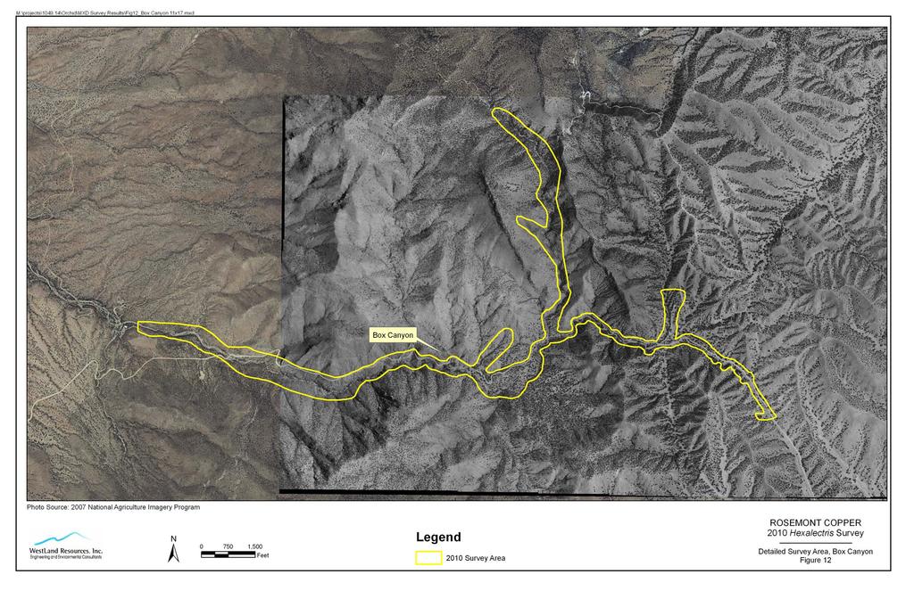
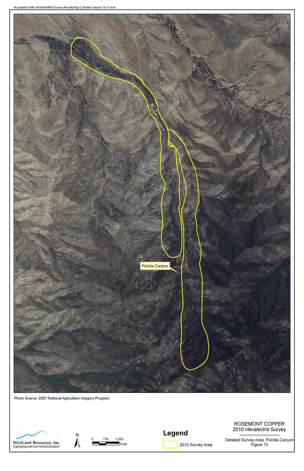
12 Field Surveys for Hexalectris colemanii in Southeastern Arizona July 28, 2010 May June 2010 Page 5 of orchids located. 2.3 SURVEY APPROACH OUTSIDE OF ROSEMONT AREA WestLand biologists, Lawson, and volunteers surveyed sites outside of the Rosemont Area. These sites either were known by Coleman to have Hexalectris or, based on our experiences in 2010, had enough patches of Arizona white oaks to warrant surveys for the orchid. WestLand surveyed Box, Florida, Agua Caliente and Montosa canyons in the Santa Rita Mountains, portions of Cochise Stronghold West and East canyons in the Big Dragoon Mountains, Solano Canyon in northeast Baboquivari Mountains, and upper Cañada del Oro Canyon in the Catalina Mountains. Lawson and volunteers examined portions of Sawmill, Cave Creek, Bear, Fish and Gardner canyons in the Santa Rita Mountains, Happy Valley, Paige Creek and Turkey Creek in the Rincon Mountains, French Joe and Guindani canyons in the Whetstone Mountains, and Brown Canyon in the Baboquivari Mountains. Details of Lawson and volunteers surveys are provided in Appendix B. Three to four WestLand biologists surveyed together in Box, Florida, Agua Caliente, and Montosa Canyons using the same survey techniques used in surveying the Rosemont Area. Lawson and the volunteers surveyed in groups of two or three people in each canyon. Handheld GPS units were set on track mode to monitor survey area coverage (details provided in Appendix B). Voucher specimens were collected and dried in a plant press. Once mounted, the specimens will be donated to the University of Arizona (ARIZ) and/or Arizona State (ASU) herbarium. Q\jobs\1000s\ \Orchids\July 28 Report\\Rosemont Hexalectris survey report 72810REV.doc WestLand Resources, Inc. Engineering and Environmental Consultants
13 Field Surveys for Hexalectris colemanii in Southeastern Arizona July 28, 2010 May June 2010 Page SURVEYORS AND SURVEY EFFORT 3. SURVEY RESULTS During the 2010 orchid surveys, WestLand surveyed the Rosemont Area, five additional canyons outside of the Rosemont Area but in the Santa Rita Mountains, two canyons in the Big Dragoon Mountains, and one canyon each in the Santa Catalina Mountains and Baboquivari Mountains (Table 1). Lawson participated in three days of surveys in the Big Dragoon Mountains. Lawson and volunteers surveyed one canyon in the Baboquivari Mountains, two canyons in the Whetstone Mountains, three canyons in the Rincon Mountains and five canyons in the Santa Rita Mountains (Table 1). The number of people surveying each site each day was used to compute the number of person-days of surveys conducted in each canyon or area (Table 2). McCleary Canyon received the greatest number of survey person-days of any of the areas surveyed, totaling 53.5 person-days. The total number of survey person-days on the Rosemont Area during May and June, 2010, was Two-thirds of the investment of time and surveyors from WestLand for the 2010 orchid season was in the Rosemont Area. The other third of the WestLand survey effort was distributed across ten canyons outside of the Rosemont Area. In Appendix B, Lawson provides the details of survey effort by volunteers for each of the canyons they surveyed outside of the Rosemont Area. Based on the number of days and the number of people surveying in each canyon, survey effort by Lawson and the volunteers was approximately 15 person-days. If survey time in the field was closer to ten hours per day than eight hours, survey effort may have approached 19 persondays. Q\jobs\1000s\ \Orchids\July 28 Report\\Rosemont Hexalectris survey report 72810REV.doc WestLand Resources, Inc. Engineering and Environmental Consultants
14 Field Surveys for Hexalectris colemanii in Southeastern Arizona July 28, 2010 May June 2010 Page 7 Table 1. All areas surveyed during the 2010 Hexalectris colemanii inventory with specific reference to canyon, mountain range, and surveyor. Canyon Mountain Range Surveyor Barrel Santa Rita WestLand Wasp Santa Rita WestLand McCleary Santa Rita WestLand Scholefield Santa Rita WestLand Sycamore in Rosemont Santa Rita WestLand Agua Caliente Santa Rita WestLand Montosa Santa Rita WestLand Florida Santa Rita WestLand Box Santa Rita WestLand Sycamore in Box Santa Rita WestLand Sawmill Santa Rita WestLand and H. Lawson Cave Creek Santa Rita H. Lawson and volunteers Fish Santa Rita H. Lawson and volunteers Gardner Santa Rita H. Lawson and volunteers West Cochise Stronghold Big Dragoons WestLand and H. Lawson East Cochise Stronghold Big Dragoons WestLand (R. Schmalzel) Cañada del Oro Santa Catalina WestLand (R. Schmalzel) Solano Baboquivari WestLand (R. Schmalzel) French Joe Whetstone A. Cordery (H. Lawson volunteer) Guindani Whetstone A. Cordery (H. Lawson volunteer) Brown Baboquivari H. Lawson and volunteers Happy Valley Rincon H. Lawson and volunteers Paige Creek Rincon H. Lawson and volunteers Turkey Creek Rincon H. Lawson and volunteers Q\jobs\1000s\ \Orchids\July 28 Report\\Rosemont Hexalectris survey report 72810REV.doc WestLand Resources, Inc. Engineering and Environmental Consultants
15 Field Surveys for Hexalectris colemanii in Southeastern Arizona July 28, 2010 May June 2010 Page 8 Table 2. Summary of WestLand survey effort for 2010 orchid inventory. Inventory Area Canyon Inventory Dates Rosemont Number of Surveyors per day Number of Person-Days* McCleary April 25, May 11, 20, 21, 24, 25, 26, & 28 Wasp May 18, 19, 21, 24 & Barrel May 19, 20, 21, 24, 25 & Sycamore May 20 & 24, June 7 & Scholefield May 18, 19, 26 & June Other June Onsite Survey Effort person days Offsite Box June June Sycamore of Box June Florida June June Agua Caliente June June Montosa June May 21, 28, June West Cochise 8 Stronghold June East Cochise June Stronghold June Solano June Sawmill May 17, Cañada del Oro June Offsite Survey Effort Total Survey Effort *10 hours per survey day per person is equal to 1.25 person days person days person days Q\jobs\1000s\ \Orchids\July 28 Report\\Rosemont Hexalectris survey report 72810REV.doc WestLand Resources, Inc. Engineering and Environmental Consultants
16 Field Surveys for Hexalectris colemanii in Southeastern Arizona July 28, 2010 May June 2010 Page SURVEY RESULTS WITHIN THE ROSEMONT AREA In May and June 2010, 15 inflorescences of H. colemanii were detected at the historic site 3 in McCleary Canyon where Coleman had been monitoring H. colemanii inflorescence in previous years. WestLand field biologists also found 109 H. colemanii inflorescences in areas within the Rosemont Area previously unknown to have Hexalectris. Of the 109 inflorescences, 105 inflorescences were found in McCleary Canyon. Ten of these were found down-stream from the historical population, while 95 were found on the higher slopes of a small watershed that entered McCleary Canyon very near the historic site. The remaining four of the 109 inflorescences were in a 1-m² patch under white oaks in a small, wet side-canyon tributary to Wasp Canyon. The site with the four H. colemanii in Wasp Canyon was at least 600 m south of the population with 95 inflorescences in the uplands, and about 1,200 m southwest of the historic site with 15 inflorescences in Given its distance from the other Hexalectris in McCleary Canyon, the Wasp Canyon location can be regarded as a new location for this species. The locations of the historic sites (both occupied and unoccupied in 2010) of H. colemanii, and the new locations in 2010 in the Rosemont Area are provided in Figure 3. In addition to the locations, Figure 3 includes the outline of the areas surveyed and the composition of tree species that characterize each of the areas surveyed within the Rosemont Area. Close-ups of the north portion and south portion of the Rosemont Area with the outlines of the surveyed areas and the location of the H. colemanii inflorescences located in 2010 are provided in Figures 4 and 5. Coleman led Lawson and Schmalzel to the spot in McCleary Canyon where in 1996 Steve McLaughlin had shown him H. colemanii (Coleman 2010, Appendix A). Coleman thought that this spot was likely the same spot where McLaughlin collected the Hexalectris specimen on May 3, 1986 (McLaughlin 3441, ARIZ). The spot where McLaughlin collected Hexalectris in 1986 is upstream and on the opposite side (north side) of the McCleary streambed from the site where we observed 15 inflorescences in Within about 15 m of the McLaughlin spot, Coleman showed us several other spots where he had observed Hexalectris between 1996 and the present; these nearby sites were also on the north side of the canyon bottom. Coleman showed us an exposed outcrop of arkose sandstone upstream from the McLaughlin spot. Coleman had seen one Hexalectris inflorescence on the rock outcrop once in the last 15 years. For Coleman, this was the farthest upstream he had found Hexalectris prior to Marc Baker collected a specimen of Hexalectris on May 28, 2003 in McCleary Canyon (M. A. Baker 15411, ASU). The location of Baker s collection is within 15 m of the McLaughlin spot and is also on the north side of the canyon bottom. The sites, those occupied in 2010, and others occupied in previous years according to Coleman, are mapped in Figure 3. Coordinates of H. colemanii historic locations are provided in Table 3. Lee Taylor ca 1998 and Aaron Kennedy in 2005 were taken by Ron Coleman to this area of McCleary Canyon to collect voucher specimens and specimens for DNA analyses. Exact locations of their voucher collections are not known. Table 3. UTM coordinates of the historic locations of Hexalectris colemanii in McCleary Canyon, Santa Rita 3 By historic location in McCleary Canyon, we mean an approximately 140 m reach of the canyon within which (a) Steve McLaughlin made the first collection of this plant in 1986, and (b) showed the spot to Ron Coleman in 1996, (c) Ron Coleman has monitored, with the exception of one year, from 1997 to 2010, and (d) Marc Baker, Lee Taylor, and Aaron Kennedy have made collections. Q\jobs\1000s\ \Orchids\July 28 Report\\Rosemont Hexalectris survey report 72810REV.doc WestLand Resources, Inc. Engineering and Environmental Consultants
17 Field Surveys for Hexalectris colemanii in Southeastern Arizona July 28, 2010 May June 2010 Page 10 Mountains in NAD 83. Location Easterly Northerly Accuracy Comments (meters) a m Up-stream end of the 140-m reach; rock outcrop where Ron Coleman saw H. colemanii growing; 3 Emory oak and 3 Arizona white oak on this rock outcrop b m Coleman has seen inflorescences of H. colemanii under grove of 6 Arizona white oaks and 3 Emory oaks c Sub-meter Marc Baker specimen (ASU) collected 28 May 2003; coordinates translated from NAD 27 on herbarium label to NAD 83 d m Likely type locality of H. colemanii; Steve McLaughlin specimen 3441 (ARIZ) collected 3 May 1986; Coleman showed Lawson and Schmalzel in 2010 the spot where in 1996 Steve McLaughlin had shown Coleman the site for H. colemanii in McCleary Canyon; only Emory oak and alligator-bark juniper at this spot e m Spot where Ron Coleman found H. colemanii inflorescence in grassy area beneath a Emory oak canopy and at least 6 m from Arizona white oak f m Upstream point of belt transect with 15 inflorescences in 2010 g m Downstream point of belt transect with 15 inflorescences in 2010 Brief description of the canyons and findings during the 2010 orchid survey efforts are provided in Table 4. Table 4. Rosemont Area surveyed Hexalectris colemanii inventory by WestLand. Survey conducted May 18- June 28 and June 7-9, UTM coordinates of orchids provided in Appendix C. Canyon General Site Description Findings Barrel Canyon White and black oak stands scattered throughout. Moderate leaf No Hexalectris observed. litter found in some areas. Dry and grassy. Mesquite dominated stands along dry slopes. McCleary Canyon White oak dominated stands found in lower portions of canyon and around 5000 feet. White and black oak mixed stands in upper reaches and dry washes. Patches of oak leaf litter throughout. Mesquite dominated stands along dry slopes. 105 new and 15 historic H. colemanii inflorescences between feet. Several new locations along canyon. Scholefield Canyon Sycamore Canyon Wasp Canyon Scattered white and black oaks. Dry slopes in canyon dominated by mesquite; grasses common throughout. Scattered white and black oaks. Dry slopes in canyon dominated by mesquite; grasses common throughout. White oak stands scattered throughout. Moderate oak leaf litter in lower reaches. Mesquite dominated stands along dry slopes. No Hexalectris observed. No Hexalectris observed. Four (4) H. colemanii inflorescences at about ft in 1-m² spot. New location. All plants were trampled on wildlife Q\jobs\1000s\ \Orchids\July 28 Report\\Rosemont Hexalectris survey report 72810REV.doc WestLand Resources, Inc. Engineering and Environmental Consultants
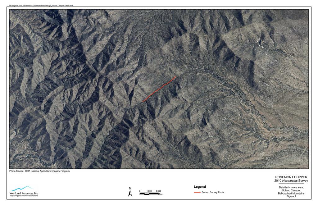
18 Field Surveys for Hexalectris colemanii in Southeastern Arizona July 28, 2010 May June 2010 Page 11 Table 4. Rosemont Area surveyed Hexalectris colemanii inventory by WestLand. Survey conducted May 18- June 28 and June 7-9, UTM coordinates of orchids provided in Appendix C. Canyon General Site Description Findings trail by June SURVEY RESULTS OUTSIDE OF THE ROSEMONT AREA Survey dates, brief descriptions of the canyons, and findings during the 2010 orchid survey efforts outside the Rosemont Area are provided in Table 5. The locations of each of the surveys for Hexalectris in 2010 are provided on a regional map (Figure 6) and for some of the canyons, including Cochise Stronghold West and East Canyons (Figure 7); Montosa, Agua Caliente, Box, and Florida canyons (Figure 8), Solano Canyon (Figure 9), upper Canada del Oro Canyon (Figure 10), and Sawmill Canyon (Figure 11). More detailed maps of the areas surveyed are provided for Box Canyon (Figure 12), Florida Canyon (Figure 13), and Agua Caliente and Montosa canyons (Figure 14). For Cochise Stronghold canyons (Figure 7), Agua Caliente and Montosa canyons (Figure 14), and Sawmill Canyon (Figure 15), the distribution of the Hexalectris inflorescences located in 2010 are shown. Table 5. Canyons surveyed outside Rosemont Holdings Hexalectris inventory by WestLand field biologists, and Holly Lawson, and volunteers. UTM coordinates of orchids provided in Appendix C. Canyon Survey Dates General Site Description Findings Sawmill Canyon, Santa Rita Mountains Box Canyon, Santa Rita Mountains South Sycamore of Box Canyon, Santa Rita Mountains Florida Canyon, Santa Rita Mountains Agua Caliente Canyon, Santa Rita Mountains 17 April and 22 May, & 2 June 2010 White oak present along washes with an accumulation of leaf litter and open understory. Patchy white oak with patchy litter along lower and middle portions. White and black oak with patchy litter in upper portions. Dry and grassy over much of canyon. 2 June 2010 White oak present in upper portions near spring with low leaf litter. Thick poison ivy. Dense vegetation. 3 & 4 June & 14 June 2010 Few patches of white oak along creek with low leaf litter. Large grove of white and black oaks along trail near 5300 feet with a contiguous canopy and deep leaf litter. Scattered white oak with low leaf litter and grassy understory along trail. Large white oak dominated area above trailhead with contiguous canopy and patchy leaf litter. White oak scattered along middle reaches of canyon with patchy leaf litter. Lower portions dry. Approximately 25 Hexalectris colemanii inflorescences. Similar to Coleman s historic counts. No Hexalectris observed. No Hexalectris observed. No Hexalectris observed. 15 Hexalectris inflorescences (likely H. arizonica); between feet. New location. Q\jobs\1000s\ \Orchids\July 28 Report\\Rosemont Hexalectris survey report 72810REV.doc WestLand Resources, Inc. Engineering and Environmental Consultants
19 Field Surveys for Hexalectris colemanii in Southeastern Arizona July 28, 2010 May June 2010 Page 12 Table 5. Canyons surveyed outside Rosemont Holdings Hexalectris inventory by WestLand field biologists, and Holly Lawson, and volunteers. UTM coordinates of orchids provided in Appendix C. Canyon Survey Dates General Site Description Findings Montosa Canyon, Santa Rita Mountains Cave Creek Canyon, Santa Rita Mountains Fish Canyon, Santa Rita Mountains Gardner Canyon, Santa Rita Mountains West Stronghold Canyon, Big Dragoon Mountains East Stronghold Canyon, Big Dragoon Mountains Solano Canyon, Baboquivari Mountains 15 June 2010 White oak dominated areas along canyon bottom with contiguous canopy and an accumulation of leaf litter. White and black oak scattered, dry and grassy in upper portions of canyon with little leaf litter. 1 June 2010 Mixed Arizona white oak stands along creek. Inventoried three white oak stands with contiguous canopies. Sweetwater Spring in floodplain terrace within moderate to dense stand of white oak. Creek was flowing. 4 June 2010 Rolling hills with white oak on the north side. Inventoried a few large and small patches of Arizona white oak with moderate canopy cover. Seep area with good white oak cover, low density understory, and moderate leaf litter. 1 June 2010 Only a few small stands of Arizona white oak. Poison ivy in areas. No running water observed. Surveyed areas near creek along the road. 10 June 2010 Forest near trailhead dominated by Arizona white oak. Contiguous canopies of oaks and an accumulation of leaf litter. 20 and 27 June 2010 June 12, 2010 Dense grove of white oak trees on flood terrace about 1.5 m above East Stronghold Canyon channel; closed canopy Broken linear arrays of white oaks along Solano Canyon bottom and on flood terraces; about five wider patches of ten or more white oaks occur in the surveyed reach of the canyon 3 Hexalectris inflorescences (likely H. arizonica); between feet. New location. No Hexalectris observed. No Hexalectris observed. No Hexalectris observed. Approximately 140 H. colemanii and a few Hexalectris that were likely H. arizonica, inflorescences observed around 5100 feet. A significant increase from Coleman s historic counts. Nearly 1/3 of inflorescences detected were grazed by deer during May-June, Hexalectris inflorescences (likely H. arizonica). New location. No Hexalectris observed. Q\jobs\1000s\ \Orchids\July 28 Report\\Rosemont Hexalectris survey report 72810REV.doc WestLand Resources, Inc. Engineering and Environmental Consultants
20 Field Surveys for Hexalectris colemanii in Southeastern Arizona July 28, 2010 May June 2010 Page 13 Table 5. Canyons surveyed outside Rosemont Holdings Hexalectris inventory by WestLand field biologists, and Holly Lawson, and volunteers. UTM coordinates of orchids provided in Appendix C. Canyon Survey Dates General Site Description Findings Upper Cañada del Oro Canyon, Santa Catalina Mountains Bear Canyon, Santa Catalina Mountains French Joe, Whetstone Mountains Guindani Canyon, Whetstone Mountains Happy Valley, Rincon Mountains Paige Creek, Rincon Mountains Turkey Creek, Rincon Mountains Brown Canyon, Baboquivari Mountains June 7, 2010 A large unburned grove of white oak exists west of the intersection of Red Ridge Trail with Cañada del Oro trail; this grove was carefully searched for the orchid. This grove has an understory of grass and forbs, so may be unsuitable for Hexalectris. Additional unburned groves of white oaks were seen in side canyons to the north of the lower portion of Red Ridge Trail; these were dense groves and have the potential for Hexalectris. Unburned scattered groves of white oaks exist farther up Cañada del Oro; these were seen only from a distance. 23 May 2010 Netleaf oak and Arizona white oak along wash. Surveyed around 5800 feet. Steep rocky slopes next to Catalina Highway. Few areas with contiguous canopy of white oak and leaf litter. 30 May 2010 Mixed oak stands only in upper and lower sections. Poison ivy in several areas with dense leaf litter. High recreational use through much of canyon. 31 May 2010 Mixed oak stands on all but south facing slopes. Dry and grassy understory. Few oak areas with well-developed canopies and deep accumulation of leaf litter. 9 June 2010 White oak in areas. Surveys were primarily done in Paige and Turkey creeks. 9 June 2010 Mixed Arizona white oak stands with dense understory of shrubs. No running water. Good oak cover on floor terraces beside creek; moderate oak leaf litter. 9 June 2010 Mixed Arizona white oak stands with large trees; few understory shrubs. Stream bed dry. Poison ivy in understory. Heavy use by recreationists. 21 June 2010 Wash bottom oak-lined. Seeps in area. Side canyons contain Mexican blue and Arizona white oak. Understory shrub composition varied between stands. Poison ivy present in patches. Canyon surveyed between feet. No Hexalectris observed. No Hexalectris observed. No Hexalectris observed. No Hexalectris observed. No Hexalectris observed. No Hexalectris observed. No Hexalectris observed. No Hexalectris observed. Between 1997 and 2001, Coleman made several trips to Cochise Stronghold West Canyon and saw individuals of Hexalectris either as dried stalks or emerging flower stalks with buds. It was not until 2001 that Coleman saw one plant with open flowers. The open flower allowed him to identify the plant in the locality as H. colemanii. At the time, Coleman did not collect a voucher specimen because, based on his observations, he Q\jobs\1000s\ \Orchids\July 28 Report\\Rosemont Hexalectris survey report 72810REV.doc WestLand Resources, Inc. Engineering and Environmental Consultants
21 Field Surveys for Hexalectris colemanii in Southeastern Arizona July 28, 2010 May June 2010 Page 14 believed that there were too few plants to justify collecting one (Appendix A). In 2010, when more than 75 inflorescences were located in Cochise Stronghold West Canyon, a voucher specimen of Hexalectris colemanii was collected by Coleman, Lawson and Schmalzel in Cochise Stronghold West Canyon on June 8, The first specimen was collected at E, N (NAD 83, 9 ft acc). A second voucher specimen of H. colemanii was collected by Schmalzel and Gabrielle Diamond in Cochise Stronghold West Canyon on June 10, The second specimen was collected at E, N (NAD 83, 9 ft acc) at 5,144 ft elevation. The second specimen was the only plant seen on June 10 with open flowers. The June 10 specimen had three open flowers, eight buds, and was 47 cm tall. A voucher specimen of Hexalectris arizonica was collected by Schmalzel on June 27, 2010, in East Cochise Stronghold Canyon at E, N (NAD 27, 3 m acc). The vouchers were dried in a plant press, with attention to pressing at least one of the flowers so that the column of the flower was exposed and evident, and for specimens of H. colemanii, the recurved sepals positions were maintained. H. colemanii was found in at least three new locations in the Rosemont Area, both down-canyon and upslope from the historic sites in McCleary Canyon. A small group of H. colemanii was located near a spring in Wasp Canyon. Our surveys in Cochise Stronghold West Canyon in 2010 increased the number of occupied sites from one to three. The largest occupied polygon in Cochise Stronghold West Canyon is at least 2.6 acres. New populations of Hexalectris arizonica were also found during surveys outside of the Rosemont area. The Hexalectris plants found in Agua Caliente and Montosa canyons in the Santa Rita Mountains, and Cochise Stronghold East Canyon in the Big Dragoon Mountains were probably in all cases H. arizonica, given the time of sprout emergence (several weeks after H. colemanii). The plants in Cochise Stronghold East Canyon did not have open flowers with reflexed petals, although in at least two cases the ovary of the flower was expanding characteristics of H. arizonica, not H. colemanii. General vegetation community characteristics in common with historically known sites and detection sites included a well-developed white oak canopy, an accumulation of oak leaf litter, and an overall lack of grasses and forbs in the understory. Garrya wrightii, Rhus trilobata and R. coriophylla were commonly observed in the Rosemont Area detection sites while R. choriophylla, G. wrightii and Rhamnus californica were typical in the understory of Cochise Stronghold Canyons. Overall, Hexalectris were found between feet, with H. colemanii specifically located at feet, in white oak dominated stands, with a relatively open understory containing few or no grasses or forbs, and with an accumulation of oak leaf litter. Q\jobs\1000s\ \Orchids\July 28 Report\\Rosemont Hexalectris survey report 72810REV.doc WestLand Resources, Inc. Engineering and Environmental Consultants
22 Field Surveys for Hexalectris colemanii in Southeastern Arizona July 28, 2010 May June 2010 Page CONCLUSIONS FROM 2010 SURVEY FOR H. COLEMANII The field surveys for Hexalectris colemanii in May and June, 2010, have expanded the known occupied sites and the maximum number of observed inflorescences in a single season for Cochise Stronghold West Canyon, McCleary Canyon, and the new site in Wasp Canyon. Contiguous canopies of Arizona white oak and Emory oak in the Rosemont Area were completely surveyed in 2010 for this species; as such, new occupied polygons are not likely to be found on the Rosemont Area in the future. In contrast, only a small portion of the contiguous canopies of Arizona white oak have been surveyed in Cochise Stronghold East and West Canyons. With the results of the 2010 field surveys, the Cochise Stronghold population of H. colemanii is now the largest known population of this species. Further surveys in subsequent years are likely to expand the known number of occupied sites in Cochise Stronghold. A large number of areas of Arizona white oak groves and Emory oak groves remain un-surveyed or undersurveyed for H. colemanii in the uplands and mountains of southeastern Arizona. Further surveys in subsequent years may locate other canyons with populations of H. colemanii. Q\jobs\1000s\ \Orchids\July 28 Report\\Rosemont Hexalectris survey report 72810REV.doc WestLand Resources, Inc. Engineering and Environmental Consultants
23 Field Surveys for Hexalectris colemanii in Southeastern Arizona July 28, 2010 May June 2010 Page REFERENCES CITED Arizona Game and Fish Department (AGFD) Hexalectris revoluta. Unpublished abstract compiled and edited by the Heritage Data Management System, Arizona Game and Fish Department, Phoenix, AZ. 5 pp. Available at internet site Accessed July 6, Catling, P. M A synopsis of the genus Hexalectris in the United States and a new variety of Hexalectris revoluta. The Native Orchid Conference Journal 1: Coleman, R.A Hexalectris revoluta in Arizona. North American Native Orchid Journal. 5(4): Coleman, R. A Tracking wild orchids in Arizona. Pp IN: Maschinski, J., and L. Holter (eds). Proceedings of the Third Conference of Southwestern Rare and Endangered Plants. U. S. Department of Agriculture, Forest Service, Rocky Mountain Research Station Proceedings RMRS-P- 23. Fort Collins, Colorado. Coleman, R. A The wild orchids of Arizona and New Mexico. Comstock Publishing Associates, a division of Cornell University Press. Ithaca, New York. Pp Kennedy, A. H Phylogeny and evolution of mycorrhizal associations in the myco-heterotrophic Hexalectris Raf. (Orchidaceae: Epidendroideae). PhD. Dissertation, Miami University, Oxford, Ohio. 89 pp. Kennedy, A.H, and L.E. Watson Species delimitations and phylogenetic relationships with the fully myco-heterotrophic Hexalectris (Orchidaceae). Systematic Botany, 35(1): NatureServe NatureServe Explorer: An online encyclopedia of life [web application]. Version 7.1. NatureServe, Arlington, Virginia. Available at Accessed July 7, Southwest Environmental Information Network (SEINet) On-line database of environmental information, maintained by Arizona State University. Available at internet site Accessed July 6, Taylor, D. L., and T. D. Bruns Independent, specialized invasions of ectomycorrhizal mutualism by two nonphotosynthetic orchids. Proceedings of the National Academy of Sciences (U.S.A.) 94: Taylor, D. L., T. D. Bruns, T. M. Szaro, and S. A. Hodges Divergence in mycorrhizal specialization within Hexalectris spicata (Orchidaceae), a non-photosynthetic desert orchid. American Journal of Botany 90: Q\jobs\1000s\ \Orchids\July 28 Report\\Rosemont Hexalectris survey report 72810REV.doc WestLand Resources, Inc. Engineering and Environmental Consultants
24 FIGURES


25 M:\projects\ \Orchid\MXD Survey Results\Fig1 Vicinity.mxd ARIZONA TUCSON METROPOLITAN AREA FLAGSTAFF PHOENIX YUMA PROJECT LOCATION TUCSON 0 0 «83 Approximate Scale 1" = 10 Miles Rosemont Analysis Area 0 T.18S., R.15E., Portion Sections 12, 13, 24, 25 & 36, T.18S., R.16E., Portion Sections 7, 8, 14-18, 19-22, & 31-34, T.19S., R.15E., Portion Section 1, T.19S., R.16E., Portion Sections 4-7, Pima County, Arizona Corona De Tucson, Empire Ranch, Helvetia & Sahuarita Legend Rosemont Area (Bounded area that encompasses all of the proposed ± alternatives to the Rosemont Mine Plan.) Rosemont area surveyed Miles for Hexalectris colemanii 1 inch = 3 miles ROSEMONT COPPER 2010 Hexalectris Survey Vicinity Map Figure 1
26 M:\projects\ \Orchid\MXD Survey Results\Fig2_Regional Map.mxd!(!(!( McCleary Canyon Cochise Stronghold West Canyon Baboquivari Canyon!( Sawmill Canyon Background Source: Bing Maps-Road ± Miles Legend!( Locations of Hexalectris colemanii known prior to 2010 ROSEMONT COPPER 2010 Hexalectris Survey Regional Map of Historic Locations of Hexalectris colemanii Figure 2

27

28

29

30


31 M:\projects\ \Orchid\MXD Survey Results\Fig7_Cochise Stronghold West and East Canyons 11x17.mxd!(!(!(!(!(!(!(!(!(!(!(!(!(!(!(!(!(!(!(!(!(!(!(!(!(!(!(!(!(!(!(!(!(!(!(!(!(!(!(!(!(!(!(!(!(!(!(!(!(!(!(!(!(!(!(!(!(!(!(!(!(!(!(!(!(!(!(!(!(!(!(!(!(!(!(!( SEE FIGURE 7a!(!( SEE FIGURE 7b VIEW A SEE FIGURE 7b VIEW B!(!(!(!( Photo Source: 2007 National Agriculture Imagery Program ± ,000 Feet Legend!( Hexalectris colemanii Cluster!( Hexalectris arizonica Cluster ROSEMONT COPPER 2010 Hexalectris Survey Overview of Survey Area, Cochise Stronghold West and East Canyons, Big Dragoon Mountains Figure 7

32
33 M:\projects\ \Orchid\MXD Survey Results\Fig7b_Cochise Stronghold West and East Canyons 11x17.mxd!(!( 3!(!( 4!( 6!( 9 VIEW A VIEW B Photo Source: 2007 National Agriculture Imagery Program ± Feet Legend # #!(!( Hexalectris colemanii Cluster and Number of Inflorescences Hexalectris arizonica Cluster and Number of Inflorescences (where only one inflorescence was observed, no number is shown) ROSEMONT COPPER 2010 Hexalectris Survey Detailed Survey Area, Cochise Stronghold West and East Canyons, Big Dragoon Mountains Figure 7b

34
35

36

37
38
39

40
41 APPENDIX A CHRONOLOGY OF FIELD NOTES AND OBSERVATIONS BY RONALD A. COLEMAN
42
43
44
45
46 APPENDIX B CONTRIBUTIONS BY HOLLY LAWSON ROSEMONT COPPER RECLAMATION SPECIALIST
47 Orchid Search Summary The McCleary Canyon site, located east side of the Santa Rita Mountains, has been monitored by Ron Coleman since 1996, when he was introduced to the site by Steve McLaughlin. Ron Coleman was contacted for his expertise on Hexalectris colemanii by U.S. mail on March 26, 2010 and responded by the following day. Coleman agreed to help Rosemont Copper and WestLand Resources with our biological surveys to further our knowledge of the orchids and to help to the USFS make the correct management decisions for the Environmental Impact Statement for the Rosemont Copper Project. Ron answered many questions about the locations in which he had been monitoring, including Sawmill Canyon, south of the McCleary Canyon site on the east side of the Santa Rita Mountains. During the orchid search on May 22, 2010, volunteers interested in and studying botany visited the McCleary Canyon and Sawmill Canyon locations. During this visit they observed the habitat and vegetation associated with the orchids at these locations, as well as obtained a search image of the orchid. Those that were not able to attend the search of this day were personally given details about the orchids, the associated vegetation and photographs of the search images. On this day Ron Coleman was able to show us the exact locations in which the herbarium specimens were collected, locations that the orchid has been found and studied in previous years and other observations that were made in previous years. During the McCleary Canyon visit, volunteers observed the orchids from the wash bottom in order to minimize disturbance of the slopes of the historic location. During the Sawmill location visit, volunteers were given the opportunity to search for the orchids to locate them within the canyon. Since the orchids do not come up in the same location every year, the orchids must be relocated within a known area each year. Each volunteer was given a handheld GPS, maps of potential orchid habitats to explore in the Santa Rita Mountains and Coronado National Forest maps. During the orchid searches, potential habitat was determined by the presence of Arizona White Oaks as well as Mexican Blue Oaks in the Baboquivari Mountains, the amount of canopy cover, the amount of oak debris. Other factors that were considered were the understory beneath the oaks, the amount of moisture in the debris and the presence of seeps and springs. When dense canopies of Arizona White Oak appeared on the map or while driving, teams would spread out and hike through the oaks. When possible, teams would hike on one side of the canyon on the way up and the other side on the way down. The orchid was generally found under dense canopies of Arizona White Oaks with little other vegetation in the understory and in oak litter at least one inch thick. Bear Canyon, Catalina Mountains: Date: 5/23/2010, 2 surveyors present (CC & HL). Riparian species were found in the wash, which was lined with Netleaf Oak and few Arizona White Oaks, as well as mixed scrub. Elevation surveyed was around 5800 feet. Steep, rocky slopes form a narrow canyon running next to the Catalina Highway. There were small areas of decent canopy cover and oak litter, but no Hexalectris spikes were found. French Joe Canyon, Whetstone Mountains. Survey date: May 30, surveyors present. Mixed oak stands present on the lower and upper reaches of the canyon, much of the central portion of the canyon was upper desert scrub with no upper canopy. The understory at much of the site appears to receive high levels of disturbance from recreational users and large herbivores. The presence of poison ivy was a positive sign along with several areas with decent amounts of oak leaf litter and moisture, however no Hexalectris stalks were observed in the area. Guindani Canyon, Whetstone Mountains. Survey date: May 31, surveyors present.
48 Mixed oak stands present on all but the south facing slopes. Understory was fairly dry and contained grass in most of the drainage. There were a few willows and cottonwoods scattered throughout the site but moisture seemed confined to only the very bottom of the canyon. There were a few instances of proper oak leaf litter and complete oak canopies, but the only shoots observed in these locations turned out to be Coral Beans (Erythrina flabelliformis) and not Hexalectris. Gardner Canyon, Santa Rita Mountains: Date: 6/1/2010, 2 surveyors (AC & HL). The survey began at the Arizona Trail and Casa Blanca trailhead. There were some good stands of pure Arizona White Oak trees with decent cover and debris and other areas where the oaks were scattered between Junipers and mixed scrub, including Poison Ivy. Only the areas where you drive next to the creek were surveyed. No running water was observed in the creek and no Hexalectris spikes were observed. Cave Creek Canyon, Santa Rita Mountains: Date: 6/1/2010, 2 surveyors (AC & HL). It was mentioned by Ron Coleman during the orchid search that he had found a dried Hexalectris spike in earlier years at the end of the Cave Creek road, where the trailhead begins. There were mixed Arizona White Oak stands separated by Arizona Sycamore, Junipers, and Seep Willows along the creek. The creek was flowing and in stretches it would flow below the ground surface. There were three white oak stands that with a lot of canopy cover, but no Hexalectis spikes were observed. The second location that was surveyed was Sweetwater Spring. The area had floodplain terraces that were gently sloped with moderate to dense stands of Arizona White Oaks. There was still water flowing through Cave Creek, though the area was used heavily by campers. No Hexalectris spikes were observed at this location. Fish Canyon, Santa Rita Mountains: Date: 6/4/2010, 2 surveyors (SG & HL). This area has rolling hills with oaks on the north sides of the canyon and gradually increases as you move west, towards the ridge of the mountain. One area surveyed in Fish Canyon had historic mining in the area and a house next to the creek. Riparian vegetation in the creek included Arizona Sycamore, Arizona Walnut, One Seed Juniper and Mesquites. There were some large Arizona White Oak trees and small patches of oaks with a large amount of oak debris under the trees, but canopy cover was moderate. Another location that was surveyed had seeps running through the creek with Arizona White Oak trees with little understory cover, a good amount of oak debris and decent canopy cover, but no Hexalectris spikes were observed. Happy Valley, Rincon Mountains: Date: 6/9/2010, 2 surveyors (SG & HL). Paige Creek: Mixed Arizona White Oak grove with a fairly dense understory, including poison ivy and manzanita. There was no water running in the creek. There was good oak canopy cover near Paige Creek with a gently sloping flood terrace and a good amount of oak litter debris. No Hexalectris spikes were observed. Turkey Creek: There was no running water observed in the creek. This is a riparian area next to oaklined gently sloping flood terraces. Species observed included Arizona White Oaks, Arizona Sycamores, Mesquites, and Poison Ivy. Areas searched had a good amount of canopy cover, little understory, oaks were large and sparsely spaced. This area is heavily used by recreationalists and campers and is actively used for grazing. No Hexalectris spikes were observed. Brown Canyon, Baboquivari Mountains: Date: 6/21/2010, 2 surveyors (RH & HL). This canyon bottom is fairly wide and narrows greatly as you climb towards the mountain ridge. The lower part of the canyon has a mixed desert scrub with a riparian lined wash and moves into oak lined canyons, grassland between canyons and riparian in the wash bottom. One seep had few, shallow pools of water, but the canyon was otherwise dry. The elevation surveyed was lower than other sites, ranging from 4400 to
49 4700 feet. There were a few side canyons with good canopy covers of Mexican Blue Oaks and Arizona White Oaks. These patches of oaks ranged from no understory to a dense understory with thick of oak debris. Other vegetation that was observed included Arizona Sycamore, Arizona Walnut, Poison Ivy, Coral Beans, Snapdragons and Arizona Grape. No Hexalectris spikes were observed. Location Date Attendees McCleary Canyon, Santa Rita Mountains 4/17/2010 Holly Lawson Sawmill Canyon, Santa Rita Mountains Bob Schmalzel McCleary Canyon, Santa Rita Mountains 5/7/2010 Ron Coleman McCleary Canyon, Santa Rita Mountains 5/14/2010 Andrew Cordery Holly Lawson West Cochise Stronghold Canyon, Dragoon 5/21/2010 Ron Coleman Mountains Holly Lawson Bob Schmalzel Orchid Search: 5/22/2010 Amanda Best McCleary Canyon, Santa Rita Mountains Ron Coleman Sawmill Canyon, Santa Rita Mountains Christina Cook Andrew Cordery Karen Howe Holly Lawson Bob Schmalzel Sarah Studd Bear Canyon, Santa Catalina Mountains 5/23/2010 Christina Cook Holly Lawson West Cochise Stronghold Canyon, Dragoon 5/28/2010 Holly Lawson Mountains Bob Schmalzel French Joe Canyon, Whetstone Mountains 5/30/2010 Andrew Cordery Guindani Canyon, Whetstone Mountains 5/31/2010 Andrew Cordery Gardner Canyon, Santa Rita Mountains 6/1/2010 Andrew Cordery Cave Creek Canyon, Santa Rita Mountains Holly Lawson McCleary Canyon, Santa Rita Mountains 6/2/2010 Gabrielle Diamond Holly Lawson Bob Schmalzel Larry Jones, USFS Beverly Everson, USFS Rick Gerhart, USFS Salek Shafiqullah, USFS Debbie Sebesta, USFS Fish Canyon, Santa Rita Mountains 6/4/2010 Holly Lawson Sue Geraci West Cochise Stronghold Canyon, Dragoon 6/8/2010 Ron Coleman Mountains Holly Lawson Bob Schmalzel Happy Valley, Rincon Mountains 6/9/2010 Holly Lawson Paige Creek Sue Geraci Turkey Creek
50 Brown Canyon, Baboquivari Mountains 6/21/2010 Roseann Hanson Holly Lawson


51
52
2.0 Physical Characteristics
 _ 2.0 Physical Characteristics 2.1 Existing Land Use for the Project The site is comprised of approximately 114 acres bounded by Highway 101 to the north, the existing town of Los Alamos to the east, State
Bear Creek Habitat Improvement Project
 06/10/10 Bear Creek Habitat Improvement Project El Paso County, Colorado Pike National Forest and Colorado Springs Utilities Owned Land Report prepared by: Eric Billmeyer Executive Director Rocky Mountain
CRAZY HORSE TRAIL GUIDE
 CRAZY HORSE TRAIL GUIDE Abridged Version: July 2016 This is a short form of our interpretive trail guide for the Crazy Horse Trail. The full version of the guide has a more detailed description of the
Trail Phasing Plan. Note: Trails in the Clear Creek Canyon area (Segments will be finalized in the future to minimize wildlife impacts
 Note: Trails in the Clear Creek Canyon area (Segments 2 5 and a future JCOS connection) will be finalized in the future to minimize wildlife impacts Trail Phasing Plan P Parking 3 Easy Trail Intermediate
April 10, Mark Stiles San Juan Public Lands Center Manager 15 Burnett Court Durango, CO Dear Mark,
 Mark Stiles San Juan Public Lands Center Manager 15 Burnett Court Durango, CO 81301 Dear Mark, We are pleased to offer the following comments on the draft San Juan Public Lands Center management plans
United States Department of the Interior National Park Service. Boundary Expansion Listed in National Register January 11, 2017
 NPS Form 10900-a (Rev. 8/2002) OMB No. 10240018 United States Department of the Interior National Park Service Boundary Expansion Listed in National Register January 11, 2017 National Register of Historic
ROAD AND TRAIL PROJECT APPROVAL
 ROAD AND TRAIL PROJECT APPROVAL www.marincountyparks.org Marin County Parks, 3501 Civic Center Dr, Suite 260, San Rafael, CA 94903 DATE: July 12, 2017 PRESERVE: Gary Giacomini Open Space Preserve PROJECT:
Theme: Predominately natural/natural appearing; rustic improvements to protect resources. Size*: 2,500 + acres Infrastructure**:
 Recreation Opportunity Spectrum (ROS) Classes The Recreation Opportunity Spectrum (ROS) provides a way to describe the variations in the degree of isolation from the sounds and influences of people, and
Non-motorized Trail Plan & Proposal. August 8, 2014
 Town of Star Valley Ranch, Wyoming and the Star Valley Ranch Association in partnership with the USDA Forest Service, Bridger-Teton National Forest, Greys River Ranger District Non-motorized Trail Plan
Kicking the Alpine Plants Out Mountain Goat Wallows In Mount Peale Research Natural Area (La Sal Mountains, Utah)
") Kicking the Alpine Plants Out Mountain Goat Wallows In Mount Peale Research Natural Area (La Sal Mountains, Utah) Marc Coles-Ritchie, Grand Canyon Trust November 21, 2017 Mountain goats are digging up
Kicking the Alpine Plants Out Mountain Goat Wallows In Mount Peale Research Natural Area (La Sal Mountains, Utah) Marc Coles-Ritchie, Grand Canyon Trust November 21, 2017 Mountain goats are digging up
Request for Proposal National Tropical Botanical Garden Lower Limahuli Preserve Emergency Stream Debris Removal
 Request for Proposal National Tropical Botanical Garden Lower Limahuli Preserve Emergency Stream Debris Removal I. Summary of Work Bids are solicited for the emergency removal of debris deposited in the
National Forests and Grasslands in Texas
 United States Department of Agriculture Forest Service National Forests and Grasslands in Texas Sam Houston NF 394 FM 1375 West New Waverly, Texas 77358 Phone 936-344-6205 Dear Friends, File Code: 1950
EXPLORING BIOMES IN GORONGOSA NATIONAL PARK
 EXPLORING BIOMES IN GORONGOSA NATIONAL PARK ABOUT THIS WORKSHEET This worksheet complements the Click and Learn Gorongosa National Park Interactive Map (http://www.hhmi.org/biointeractive/gorongosa-national-park-interactive-map),
Pinellas County Environmental Lands
 Pinellas County Environmental Lands In addition to traditional parks and recreation facilities, Pinellas County owns and manages a system of environmental lands that provides specialized resource-based
 Page 1 of 5 Log In New SEINet Account Help Home > Collections > Search Criteria > Specimen Records Species List Specimen List Maps Dataset: ; ASU Taxa: Tragia laciniata 1 Page 1, records 1-48 of 48 Arizona
ROBERTS CREEK PROVINCIAL PARK MASTER PLAN. November, 1981
 Ministry of Lands, Parks and Housing Parks and Outdoor Recreation Division Park Operations Branch North Vancouver, B. C. ROBERTS CREEK PROVINCIAL PARK MASTER PLAN November, 1981 Mr. G. Trachuk Director
SEGMENT ASSESSMENT REPORT
 2017 SEGMENT ASSESSMENT REPORT SEGMENT 3: MT ROSE / TAHOE MEADOWS TO SPOONER SUMMIT REPORT SUMMARY This report is a compilation of information collected on the Tahoe Rim Trail during assessments performed
SeagrassNet Monitoring in Great Bay, New Hampshire, 2016
 University of New Hampshire University of New Hampshire Scholars' Repository PREP Reports & Publications Institute for the Study of Earth, Oceans, and Space (EOS) 9-28-2017 SeagrassNet Monitoring in Great
Rockin River Ranch State Park
 Rockin River Ranch State Park Public Meeting No. 3 August 16 th, 2017 Arizona State Parks and Trails (ASPT) Welcome Executive Director Sue Black Park budget = $4 million Balance of recreation uses, environment,
EXECUTIVE SUMMARY PROGRAM DEVELOPMENT REPORT PURPOSE EXISTING SETTING EXPANDING PARKLAND
 EXECUTIVE SUMMARY PROGRAM DEVELOPMENT REPORT PURPOSE As the culmination of the first phase of the master planning process, this Program Development Report creates the framework to develop the Calero County
A GIS Analysis of Probable High Recreation Use Areas in Three Sisters Wilderness Deschutes and Willamette National Forests
 Lindsey Kiesz Geo 565 Term Project 3/15/2010 A GIS Analysis of Probable High Recreation Use Areas in Three Sisters Wilderness Deschutes and Willamette National Forests Introduction The Three Sisters Wilderness
Final Recreation Report. Sunflower Allotment Grazing Analysis. July 2015
 Final Recreation Report Sunflower Allotment Grazing Analysis July 2015 Table of Contents Introduction... 3 Affected Environment... 3 Four Peaks Wilderness Area... 3 Dispersed Recreation... 3 Environmental
Ouimet Canyon Provincial Nature Reserve. Management Plan
 Ouimet Canyon Provincial Nature Reserve Management Plan NOTE: This document has been scanned and formatted, and therefore is slightly different from the original version. -March 2002 Additional copies
Robson Valley Avalanche Tract Mapping Project
 Robson Valley Avalanche Tract Mapping Project Prepared for: Chris Ritchie Ministry of Water Land and Air Protection 325 1011 4th Avenue Prince George, BC. V2L3H9 and Dale Seip Ministry of Forests 1011
Logo Department Name Agency Organization Organization Address Information 5700 North Sabino Canyon Road
 Logo Department Name Agency Organization Organization Address Information United States Forest Coronado National Forest 5700 North Sabino Canyon Road Department of Service Santa Catalina Ranger District
Chuckanut Ridge Fairhaven Highlands EIS Scoping Concerns
 Chuckanut Ridge Fairhaven Highlands EIS Scoping Concerns Coalition of Southside Neighborhoods CSN Comments for Fairhaven Highlands EIS Scope Hearing, Jan 16, 2008 1 Chuckanut Ridge Hilly Terrain: Potential
RANGE EXTENSIONS FOR ERYTHRANTHE ARVENSIS AND E. HALLII (PHRYMACEAE)
") Nesom, G.L. 2016. Range extensions for Erythranthe arvensis and E. hallii (Phrymaceae). Phytoneuron 2016-80: 1 5. Published 12 December 2016. ISSN 2153 733X RANGE EXTENSIONS FOR ERYTHRANTHE ARVENSIS AND
Nesom, G.L. 2016. Range extensions for Erythranthe arvensis and E. hallii (Phrymaceae). Phytoneuron 2016-80: 1 5. Published 12 December 2016. ISSN 2153 733X RANGE EXTENSIONS FOR ERYTHRANTHE ARVENSIS AND
Region 1 Piney Woods
 Region 1 Piney Woods Piney Woods 1. This ecoregion is found in East Texas. 2. Climate: average annual rainfall of 36 to 50 inches is fairly uniformly distributed throughout the year, and humidity and temperatures
Mark West Creek Flow Study Report
 Mark West Creek Flow Study Report Biology and Geology of Mark West Creek The headwaters of Mark West Creek are located in the Mayacamas Mountain range, which border Napa and Sonoma County, where it then
BOULDER CREEK CATTLE FENCING FOR KOKANEE HABITAT ENHANCEMENT 2010
 BOULDER CREEK CATTLE FENCING FOR KOKANEE HABITAT ENHANCEMENT 2010 Prepared for the: FISH & WILDLIFE COMPENSATION PROGRAM, NELSON, B.C. Prepared by: Marc André Beaucher CRESTON VALLEY WILDLIFE MANAGEMENT
HEADQUARTERS WEST LTD. PHOENIX - TUCSON - SONOITA - COTTONWOOD - ST. JOHNS
 Offered for sale exclusively by: Walter Lane Headquarters West, Ltd. PO BOX 37018 Tucson, AZ 85740 Phone (520) 792-2652 info@headquarterswest.com www.headquarterswest.com General Area Description The Crown
Blanco Creek Ranch Acres, Uvalde County, Texas
 Blanco Creek Ranch 1208.30 Acres, Uvalde County, Texas James King, Agent Office 432 426.2024 Cell 432 386.2821 James@KingLandWater.com Blanco Creek Ranch 1208.30 acres Uvalde County, Texas James King,
Dr. Melissa Grigione And Kurt Menke. Jaguar -Arturo. Jaguarundi -Arturo. Ocelot -Arturo. Caso. Caso. Caso
 Identifying Priority Conservation Areas in the U.S.- Mexico Border Region for America s Neotropical Cats, the Jaguar, Jaguarundi and Ocelot: An International Effort Dr. Melissa Grigione And Kurt Menke
You can learn more about the trail camera project and help identify animals at WildCam Gorongosa (
 INTRODUCTION Gorongosa National Park is a 1,570-square-mile protected area in Mozambique. After several decades of war devastated Gorongosa s wildlife populations, park scientists and conservation managers
Ep156 Miller's Grove (2.3 ha) TL
 TL") Ep156 Miller's Grove (2.3 ha) TL 520040 Miller's Grove is located just within the extreme eastern boundary of Ongar Great Park, a medieval deer park dating from the 11 th century. This broadleaved woodland
Ep156 Miller's Grove (2.3 ha) TL 520040 Miller's Grove is located just within the extreme eastern boundary of Ongar Great Park, a medieval deer park dating from the 11 th century. This broadleaved woodland
APPENDIX D: SUSTAINABLE TRAIL DESIGN. APPENDICES Town of Chili Parks and Recreation Master Plan Update
 APPENDIX D: SUSTAINABLE TRAIL DESIGN APPENDICES Town of Chili Parks and Recreation Master Plan Update Sustainable Trail Construction Sustainable trails are defined by the US Forest Service as trails having
BACKGROUND DECISION. Decision Memo Page 1 of 6
 DECISION MEMO DEVIL S ELBOW BY-PASS, BOUNDARY TRAIL NO.1 U.S. FOREST SERVICE T9N, R7E, SECTION 9 RANGE 5E COWLITZ COUNTY WA MOUNT ST. HELENS NATIONAL VOLCANIC MONUMENT, GIFFORD PINCHOT NATIONAL FOREST
AN ARCHAEOLOGICAL ASSESSMENT OF BOERNE CITY PARK, KENDALL COUNTY, TEXAS. Thomas C. Kelly and Thomas R. Hester
 AN ARCHAEOLOGICAL ASSESSMENT OF BOERNE CITY PARK, KENDALL COUNTY, TEXAS Thomas C. Kelly and Thomas R. Hester Center for Archaeological Research The University of Texas at San Antonio Archaeological Survey
The Appleton Wetland; Its Decline, Cause and Recommended Action. Appendix K: Wetland Inspection
 The Appleton Wetland; Its Decline, Cause and Recommended Action Appendix K: Wetland Inspection Report prepared by Appleton Wetland Research Group of the Mississippi Valley Field Naturalists Research Group
ANAGEMENT. LAN November, 1996
 M ANAGEMENT P LAN November, 1996 for Paul Lake Provincial Park Ministry of Environment, Lands and Parks BC Parks Department Paul Lake Provincial Park M ANAGEMENT P LAN Prepared by BC Parks Kamloops Area
The following criteria were used to identify Benchmark Areas:
 7.0 BENCHMARK AREAS The Churn Creek Protected Area offers a significant opportunity to learn more about how grassland ecosystems function. One of the key tools that will be used to monitor larger grassland
Subject to sale, withdrawal, or error.
 The Crawford L Bar Ranch is located approximately 40 air miles west of Albuquerque, New Mexico. This ranch truly epitomizes the description of New Mexico being the Land of Enchantment. The topography and
Cultural Resource Management Report Deer Valley 4wd Restoration and Blue Lakes Road Maintenance Project R
 Cultural Resource Management Report R2015-05-03-10005 Undertaking Description: The proposes to perform road maintenance and meadow restoration on the Deer Valley 4wd trail and road maintenance on the Blue
White Mountain National Forest Saco Ranger District
 United States Department of Agriculture Forest Service White Mountain National Forest Saco Ranger District 33 Kancamagus Highway Conway, NH 03818 Comm: (603) 447-5448 TTY: (603) 447-3121 File Code: 1950
Table 1: Rancho Carrillo Communication Site. Latitude 1 Longitude 1 Elev 2 Address T/R/S 3 APN 4 USGS Quadrangle
 County of Riverside Public Safety Enterprise Communication Project Appendix A: Candidate Site Descriptions Overview The site is located in the Cleveland National Forest (CNF) atop a low ridge adjacent
St. Joe Travel Management EA CULTURAL RESOURCES
 St. Joe Travel Management EA CULTURAL RESOURCES Bruce Gibson May 2015 Regulatory Framework Forest Plan The Idaho Panhandle National Forests (IPNF) Forest Plan requires systematic cultural resource inventory
DATE: January 19, WCA Governing Board. Johnathan Perisho, Project Manager. Mark Stanley, Executive Officer
 Item 14 DATE: January 19, 2017 TO: FROM: THROUGH: SUBJECT: WCA Governing Board Johnathan Perisho, Project Manager Mark Stanley, Executive Officer Item 14: Consideration of a resolution to accept an acquisition
Oak Ridges Moraine: Southern Ontario's Sponge
 Oak Ridges Moraine: Southern Ontario's Sponge Lesson Overview Students will examine the location and the importance of the Oak Ridges Moraine and investigate ongoing conflicts concerning its development.
AURORA WILDLIFE RESEARCH
 AURORA WILDLIFE RESEARCH Kim Poole 2305 Annable Rd. Nelson, BC, V1L 6K4 Canada Tel: (250) 825-4063; Fax: (250) 825-4073 e-mail: klpoole@shaw.ca 27 April 2005 Mike Gall Conservation Specialist and Glenn
UNCLASSIFIED//FOR OFFICIAL USE ONLY Page 1 OF 10
 Arizona Wing Civil Air Patrol UNCLASSIFIED//FOR OFFICIAL USE ONLY Repeater Plan 2 February 2012 UNCLASSIFIED//FOR OFFICIAL USE ONLY Page 1 OF 10 Repeater Plan tomize This Report UNCLASSIFIED//FOR OFFICIAL
Appendix 8.D Water Vole and Otter Survey Report
 Appendix 8.D Water Vole and Otter Survey Report Entec UK Limited Entec UK Limited Water Vole and Otter Survey Report June 2009 Final Client Job Name Report title File reference E.ON Renewables Ltd Water
Frazier Canyon Ranch 3,020 Acres Jeff Davis County, Texas
 Frazier Canyon Ranch 3,020 Acres Jeff Davis County, Texas James King, Agent Office 432 426.2024 Cell 432 386.2821 James@KingLandWater.com Frazier Canyon Ranch 3,020 acres Jeff Davis County, Texas James
Final Environmental Impact Statement for the Merced Wild and Scenic River. Comprehensive Management Plan, Yosemite National Park, Madera and Mariposa
 This document is scheduled to be published in the Federal Register on 02/26/2014 and available online at http://federalregister.gov/a/2014-04061, and on FDsys.gov DEPARTMENT OF THE INTERIOR 4312-FF NATIONAL
What Is An Ecoregion?
 Ecoregions of Texas What Is An Ecoregion? Ecoregion a major ecosystem with distinctive geography, characteristic plants and animals, and ecosystems that receives uniform solar radiation and moisture Sometimes
Chapter 8: Colorado Plateau State Highway 141, Dove Creek to Naturita
 State Highway 141 Dove Creek to (61 miles) Summary: Highway 141 heads north from US Highway 491 about two miles northwest of the town of Dove Creek. Initially, the highway runs through gently rolling farming
Coronado National Forest Santa Catalina Ranger District
 United States Department of Agriculture Forest Service Coronado National Forest Santa Catalina Ranger District File Code: 1950 Date: October 14, 2015 Dear Interested Party: The Santa Catalina Ranger District
DIDYMO SURVEY, LOWER FRYINGPAN RIVER, BASALT, COLORADO 2015
 DIDYMO SURVEY, LOWER FRYINGPAN RIVER, BASALT, COLORADO 2015 Second Annual Report PREPARED FOR: ROARING FORK CONSERVANCY PREPARED BY: COLORADO MOUNTAIN COLLEGE NATURAL RESOURCE MANAGEMENT PROGRAM TIMBERLINE
2.0 PARK VISION AND ROLES
 2.0 PARK VISION AND ROLES 2.1 Significance in the Protected Area System Marble Range and Edge Hills provincial parks protect 6.8% of the Pavillion Ranges Ecosection, which is located in the Southern Interior
Segment 2: La Crescent to Miller s Corner
 goal of the USFWS refuges is to conserve, protect and enhance fish, wildlife and plants and their habitats for the continuing benefit of the American people. Refuge lands are used largely for fishing,
Original Report F WIN , F WIN Prepared for Northland Power and Ministry of Tourism and Culture
 STAGE 2 ARCHAEOLOGICAL ASSESSMENT McLEAN S MOUNTAIN WIND FARM Part Lots 12-15, Concession 3 Geographic Township of Howland Part Lot 24, Concession 12 Geographic Township of Bidwell and Goat Island (formerly
David Magney Environmental Consulting
 David Magney Environmental Consulting DELINEATION OF JURISDICTIONAL WATERS AND RIPARIAN HABITATS FOR LYONS CANYON RANCH, NEWHALL, CALIFORNIA Prepared for: UNITED STATES ARMY CORPS OF ENGINEERS and CALIFORNIA
KP Lasnaya 1 River
 KP 370.2 Lasnaya 1 River The Lasnaya 1 River crossing is protected by Reno mattings and a gabion wall on the north bank (Photo 1). The south bank consists of natural river gravel deposits on top of Reno
Quarterly Report. 4 December February 2014
 Quarterly Report Faculty of FORESTY 4 December 2013 28 February 2014 School of AGRICULTURAL, FOREST, AND ENVIRONMENTAL SCIENCES College of AGRICULTURE, FORESTRY & LIFE SCIENCES Baruch Institute of Coastal
Survey of Littleton Down
 Survey of Littleton Down 05 November 2014 The Team: John and Jenny Barnard 1) Introduction Littleton Down (Hill Number 2911, Section 42, OS 1:50000 Map 197, OS 1:25000 Map 121, Grid Ref. SU941150) is listed
Wilderness Research. in Alaska s National Parks. Scientists: Heading to the Alaska Wilderness? Introduction
 Wilderness Research in Alaska s National Parks National Park Service U.S. Department of Interior Scientists: Heading to the Alaska Wilderness? Archeologist conducts fieldwork in Gates of the Arctic National
Significant Natural Area Assessment. Property Name: Hillend Station
 Private Bag 50072, Queenstown 9348, New Zealand QUEENSTOWN, 10 Gorge Road, Phone +64 3 441 0499, Fax +64 3 450 2223 WANAKA, 47 Ardmore Street, Phone +64 3 443 0024, Fax +64 3 450 2223 Significant Natural
Massanutten Mountain Cluster
 Massanutten Mountain Cluster Signal Knob Catback Mountain Southern Massanutten Mountain Five areas of almost 49,000 acres on the Lee Ranger District compose the Massanutten Mountain Cluster of Mountain
Town of Oakfield Agricultural and Farmland Protection Plan
 SECTION III COMMUNITY OVERVIEW A. Regional Setting / Location The Town of Oakfield is located in the northwestern portion of Genesee County. Located west of New York's Finger Lakes, the Town is uniquely
County of Riverside - PSEC Project General Habitat Assessment Appendix A
 County of Riverside - PSEC Project General Habitat Assessment Appendix A Paradise Paradise The Paradise study area is located in the mountains within the eastern portion of the City of Norco. Existing
Table 1: Santiago Peak Communication Site. Latitude 1 Longitude 1 Elev 2 Address T/R/S 3 APN 4 USGS Quadrangle
 County of Riverside Public Safety Enterprise Communication Project Appendix A: Candidate Site Descriptions Overview The site is located in the Cleveland National Forest (CNF) at an existing communication
Thank you for this second opportunity to comment on the proposed revisions to the Coconino National Forest Management plan.
 March 8, 2011 Flagstaff Biking Organization PO Box 23851 Flagstaff, AZ 86002 Yewah Lau Coconino National Forest Attn: Plan Revision 1824 South Thompson Street Flagstaff, Arizona 86001 Sent via electronic
Appalachian Power Company Smith Mountain Hydroelectric Project FERC No Debris Management Plan
 Appalachian Power Company Smith Mountain Hydroelectric Project FERC No. 2210 Debris Management Plan Final July2008 TABLE OF CONTENTS Description Page SUMMARY 1 1.0 Introduction.. 2 1.1 Project Lands and
HIGH COUNTRY L-BAR RANCH
 HIGH COUNTRY L-BAR RANCH Sandoval and mckinley counties N e w m e x i c o Jim Haworth, Ranch Team Lead Broker ~ 505-235-5236 3613 NMSR 528 NW, Ste. H, Albuquerque, NM 87114 505-792-3713 www.wwrealty.com
Carson City Open Space APNs and , west of Deer Run Road bridge
 32 acres (See separate packet for information on this open space property) OPEN SPACE PROPERTY APNs 008-541-73 and 008-541-92 (north and south sides of the river) Morgan Mill Road River Access Area (parking
Decision Memo for Desolation Trail: Mill D to Desolation Lake Trail Relocation
 for Salt Lake County, Utah Uinta-Wasatch-Cache National Forest Salt Lake Ranger District 1. Background The present location of the Desolation Trail (#1159) between Mill D and Desolation Lake follows old
Appendix C. Tenderfoot Mountain Trail System. Road and Trail Rehabilitation Plan
 Appendix C Tenderfoot Mountain Trail System Road and Trail Rehabilitation Plan All rehabilitation work would be under the direction of the District Fisheries Biologist, the Forest Hydrologist, and/or the
Aquatic insect surveys at Mount Magazine State Park and Hobbs State Park Conservation Area with implementation of an educational component
 Aquatic insect surveys at Mount Magazine State Park and Hobbs State Park Conservation Area with implementation of an educational component Arkansas is home to a relatively large number of endemic invertebrates
COMMUNITY MEETING NOVEMBER 1, Wheaton Regional Park Pine Lake Trail
 COMMUNITY MEETING NOVEMBER 1, 2012 MEETING AGENDA I. Introduction of Project Team II. Trail Renovation Process III. Wheaton Regional Park IV. Pine Lake Trail Renovation Project V. Comments and Questions
DOYLE SPRINGS PLANNING UNIT Kern-Tule River Watershed
 Existing Conditions & Uses Overview Consists of a mostly forested parcel with small hydropower developments and part of a private recreation cabin development, along with two small transmission line corridor
291-ACRE WATSONVILLE MUNICIPAL AIRPORT STUDY AREA
 THIRD ANNUAL SANTA CRUZ TARPLANT POPULATION ASSESSMENT FOR THE 291-ACRE WATSONVILLE MUNICIPAL AIRPORT STUDY AREA CITY OF WATSONVILLE, SANTA CRUZ COUNTY, CALIFORNIA Prepared for: CITY OF WATSONVILLE, WATSONVILLE
Phoenix Habitat Restoration Projects
 Phoenix Habitat Restoration Projects Spur Cross Ranch Cave Creek (Estergard) Regional Tree and Shade Summit March 9, 2010 Desert Riparian Ecosystems Healthy riparian areas like this once existed along
Trail Assessment Report
 Trail Assessment Report Trail Options for the Bear Creek Canyon located in Pikes Peak Ranger District, Pike National Forest and on Colorado Springs Utility Lands Due to the presence of a unique species
Keeping Wilderness Wild: Increasing Effectiveness With Limited Resources
 Keeping Wilderness Wild: Increasing Effectiveness With Limited Resources Linda Merigliano Bryan Smith Abstract Wilderness managers are forced to make increasingly difficult decisions about where to focus
Finn Creek Park. Management Direction Statement Amendment
 Finn Creek Park Management Direction Statement Amendment November 2013 Management Direction Statement Amendment Approved by: Jeff Leahy Regional Director, Thompson Cariboo BC Parks November 12, 2013 Date
Rogue Gorge (Mt. Stella) Roadless Area-- T30S R3E (primarily in portions of Sections 23, 26, 33, 34 & 35)
 Roadless Area-- T30S R3E (primarily in portions of Sections 23, 26, 33, 34 & 35)") Rogue Gorge (Mt. Stella) Roadless Area-- T30S R3E (primarily in portions of Sections 23, 26, 33, 34 & 35) Rogue River-Siskiyou National Forest--High Cascades Ranger District Upper, higher elevation trail
Rogue Gorge (Mt. Stella) Roadless Area-- T30S R3E (primarily in portions of Sections 23, 26, 33, 34 & 35) Rogue River-Siskiyou National Forest--High Cascades Ranger District Upper, higher elevation trail
Hydraulic Report. Trail 5 Snowmobile Trail Over Mulligan Creek. Prepared By: COLEMAN ENGINEERING COMPANY Karisa V. Falls, P.E.
 Prepared for: Prepared by: Marquette County Road Commission Coleman Engineering Company Marquette, Michigan Iron Mountain, MI December 2011 Hydraulic Report Trail 5 Snowmobile Trail Over Mulligan Creek
Yard Creek Provincial Park. Management Plan
 Yard Creek Provincial Park Management Plan Draft January 2010 Yard Creek Provincial Park Management Plan Approved by: telàlsemkin/siyam/chief Scott Benton Bill Williams Squamish Executive Director ation
Environmental Development of River Road Ranch
 Environmental Development of River Road Ranch New Braunfels, Texas Alix Scarborough GEO 3426 April 2012 Introduction The 2,400-acre Word-Borcher ranch has been owned by the Word family since 1941. Located
White Oak Creek. Recreational Use Attainability Analysis Summary of Findings. Texas Institute for Applied Environmental Research Stephenville, Texas
 White Oak Creek Recreational Use Attainability Analysis Summary of Findings Texas Institute for Applied Environmental Research Stephenville, Texas August 8, 2016 Sulphur Springs, Texas August 9, 2016 Mount
Existing Resource Information
 Botanical and Wildlife Vegetation alliances/wildlife habitats Grasslands annual/perennial Chaparral mixed/montane/chamise-redshank Riparian montane/valley foothill riparian Sierran mixed conifer Montane
RECREATION. Seven issues were identified that pertain to the effects of travel management on outdoor recreation within portions of the project area.
 RECREATION Seven issues were identified that pertain to the effects of travel management on outdoor recreation within portions of the project area. OPPORTUNITIES FOR SOLITUDE / QUIET TRAILS. One attraction
Bradley Brook Relocation Project. Scoping Notice. Saco Ranger District. United States Department of Agriculture Forest Service
 Bradley Brook Relocation Project United States Department of Agriculture Forest Service Scoping Notice White Mountain National Forest February 2011 For Information Contact: Jenny Burnett White Mountain
County of Riverside - PSEC Project General Habitat Assessment Appendix A
 County of Riverside - PSEC Project General Habitat Assessment Appendix A Lake Elsinore Lake Elsinore The Lake Elsinore study area is located in the hills directly adjacent to Lake Elsinore, in the City
proof Northwest District
 1 Northwest District The Northwest Florida Water Management District is the most rural of all five water management districts. From just east of Tallahassee west to the Florida/Alabama line, and from the
Recreational Use Attainability Analysis Summary of Findings & Public Comment
 The Neches River Above Lake Palestine, Prairie Creek, Mud Creek, and West Mud Creek Recreational Use Attainability Analysis Summary of Findings & Public Comment Texas Institute for Applied Environmental
II. GENERAL DESCRIPTION OF ENVIRONMENTAL SETTING
 II. GENERAL DESCRIPTION OF ENVIRONMENTAL SETTING A. LOCATION AND BOUNDARIES The proposed Canyon Hills project site is located at 8000 West La Tuna Canyon Road in the City of Los Angeles (the City ). The
San Juan Resource Area Recreation Impact Inventory/Monitoring
 San Juan Resource Area Recreation Impact Inventory/Monitoring Indian Creek Climbing Area Overview & Summary of Findings 2007 Pam Foti, Professor Aaron Divine, Lecturer Janet Lynn, Program Coordinator Northern
NOTICE OF INTENT MAPS WITH DESCRIPTIONS
 NOTICE OF INTENT MAPS WITH DESCRIPTIONS Location Map(s) to Accompany Notice of Intent The small corner map embedded in the lower left corner of the large map above shows the location of the three national
Procedure for the Use of Power-Driven Mobility Devices on Mass Audubon Sanctuaries 1 September 17, 2012
 Procedure for the Use of Power-Driven Mobility Devices on Mass Audubon Sanctuaries 1 September 17, 2012 Background As part of Mass Audubon s mission to preserve the nature of Massachusetts for people and
Tranquil Wood Rhewl, near Ruthin, Denbighshire acres of medal-winning hardwoods for 26,500 (freehold)
") WOODS 4 SALE Phone: 01248 364 362 www.woods4sale.co.uk UK Woodland & Woods For Sale: Specialising in the Sales of Small Woodlands in England, Scotland and Wales for Recreation, Wildlife Conservation and
WOODS 4 SALE Phone: 01248 364 362 www.woods4sale.co.uk UK Woodland & Woods For Sale: Specialising in the Sales of Small Woodlands in England, Scotland and Wales for Recreation, Wildlife Conservation and