Which was your favorite Exchange Point & why? Your Team s favorite part of the KT82?
|
|
|
- Angelina Atkins
- 5 years ago
- Views:
Transcription
1 1

2 1
3
4 Which was your favorite Exchange Point & why? Your Team s favorite part of the KT82? Did any Volunteer or Security Person go above and beyond to assist your team? Any Additional Comments you wish to share about your KT82 experience? 3

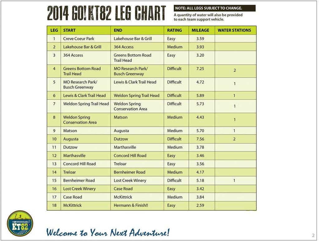
5 OVERVIEW of CREVE COEUR PARK AREA KT 82 Start Drury Hotel APPROACH ROUTES to START 270 to Dorse West to Marine Avenue to Creve Coeur Park 364 to 141 North to Marine Avenue to Creve Coeur Park 40 / 64 to 141 North to Marine Avenue to Creve Coeur Park 70 to 141 South to Marine Avenue to Creve Coeur Park 4

6 START AREA at CREVE COEUR PARK Marine Ave, Marine Avenue Entrances Check in & Support Vehicle Inspec on Support Vehicle Parking Start Start Area = 3 Rest Rooms 5 Portable Toilets Aid Sta on 5

7 DRIVING DIRECTIONS, LEG 1. START at CREVE COEUR PARK to LAKEHOUSE BAR & GRILL START DIRECTIONS = Le on Marine, 1.1 miles Le on 141 / Maryland Heights Expressway,.8 miles Le on Creve Coeur Mill Road, 1.8 miles Le in to Lakehouse Bar & Grill Parking Approximate Driving Time = 8 minutes RUN ROUTE = 3.59 MILES North on path around Creve Coeur Lake Trail Passes Under 364 Right Turn on Path Le Turn to Lakehouse B&G 6

8 EXCHANGE 1, LAKEHOUSE BAR & GRILL Lakehouse Bar & Grill Support Vehicle Parking Exchange 1 = Portable Toilet. 7

9 DRIVING DIRECTIONS, LEG 2. LAKEHOUSE BAR & GRILL to 364 ACCESS 364 ACCESS EXCHANGE 2 DIRECTIONS = Right on Creve Coeur Mill Road, 1.8 mile Le on 141 / Maryland Heights Expressway, 1.1 miles Right on 364 West, 2.5 miles Exit 14 toward S. River Road,.4 miles Right on S. River Road and immediate Right on Hemsath Road,.3 Miles Right in to 364 Access Parking Lot RUN ROUTE = 3.93 Miles Leave Lakehouse exchange Le on Katy Trail connector Cross 364 Bridge To Exchange 2 Approximate driving me = 9 minutes 8

10 EXCHANGE 2, 364 ACCESS Support Vehicle Parking EXCHANGE 2 = 2 Portable Toilets 9

11 DRIVING DIRECTIONS, LEG ACCESS to GREENS BOTTOM ROAD TRAIL HEAD 364 ACCESS X GREENS BOTTOM ROAD TRAIL HEAD EXCHANGE 3 DIRECTIONS = Right on S. River Road,.1 miles Le on S. River Road / Arena Parkway, 2.2 miles S. River Road becomes Upper Bo om Road Le on Jungs Sta on Road,.6 miles CAUTION=TRAIL CROSSING!!! RUN ROUTE = 3.20 MILES Right hand turn on to Katy Trail Greens Bo om Road Crosses Trail To Exchange 3 Jungs Sta on Road becomes Greens Bo om Road Con nue on Greens Bo om Road, 1.3 miles Le in to Greens Bo om Road Trail Head for Exchange 3 Parking Approximate Travel Time = 8 minutes 10

12 EXCHANGE 3, GREENS BOTTOM ROAD Rest Rooms Support Vehicle Parking EXCHANGE 3 = 2 Rest Rooms 11


13 LEG 4, DRIVING DIRECTIONS. GREENS BOTTOM ROAD to MISSOURI RESEARCH PARK / BUSCH GREENWAY x Missouri Research Park Trail Head DIRECTIONS = Le on Greens Bo om Road,.6 miles Right on Caulks Hill Road, CAUTION!! TRAIL CROSSING!! Con nue on Caulks Hill Road,.5 miles Le on Towers Road, 2 miles At Stop Sign, le on Towers Road,.1 miles Right on Pitman Hill Road, 1.6 miles Le to 94 West, 3.9 miles Le at Missouri Research Park Drive, 1.1 miles RUN ROUTE = 7.25 MILES Water Sta on at 2.40 Miles Greens Bo om Road crosses Trail Water Sta on at 40/61 overpass, Mile 5.52 Right turn on the Missouri Research Park Trail To Exchange 4 Le at Duckett Creek & Busch Greeenway Signs to Parking,.5 miles Approximate Driving Time = 19 minutes 12

14 EXCHANGE 4, MISSOURI RESEARCH PARK / BUSCH GREENWAY Over ow SV Parking Support Vehicle Parking EXCHANGE 4 = 2 PORTABLE TOILETS MED STATION 1 13


15 LEG 5, DRIVING DIRECTIONS. MISSOURI RESEARCH PARK / BUSCH GREENWAY to WELDON SPRING CONSERVATION AREA / LEWIS & CLARK TRAIL HEAD DIRECTIONS = Exit parking,.5 miles Right on Research Park Drive, 1.1 miles Le on 94 West, 2.4 Mile Le at sign for Weldon Spring Conserva on Area / Lewis & Clark Trail Head Parking Approximate Driving Time = 9 minutes RUN ROUTE = 4.72 MILES Missouri Research Park trail Right on to Katy Trail Water Sta on at Mile 1.99 Right in to Weldon Spring Conserva on Area Uphill and single track to Lewis & Clark Trail Head 14


16 EXCHANGE 5, WELDON SPRING CONSERVATION AREA / LEWIS & CLARK TRAIL HEAD Support Vehicle Parking EXCHANGE RULES = Le in to Exchange 5 Parking To Exit, make Le on Hwy 94 toward Exchange 6 Exchange 5 = 2 Portable Toilets. 15


17 LEG 6, DRIVING DIRECTIONS. WELDON SPRING CONSERVATION AREA / LEWIS & CLARK TRAIL HEAD to WELDON SPRING TRAIL HEAD DIRECTIONS = Le on 94 West, 2.7 miles Le to Weldon Spring Trail Head,.2 miles CAUTION!! TRAIL CROSSING!! Le in to Parking Approximate Driving Time = 6 minutes RUN ROUTE = 5.89 MILES Single Track & Downhill on the Clark Trail Right turn on to Katy Trail Water Sta on at Mile 3.28 To Exchange 6 16

18 EXCHANGE 6, WELDON SPRING TRAIL HEAD Rest Rooms Support Vehicle Parking MED STATION 2 EXCHANGE 6 = 2 REST ROOMS 17

19 LEG 7, DRIVING DIRECTIONS. WELDON SPRING TRAIL HEAD to WELDON SPRING CONSERVATION AREA DIRECTIONS = Right to exit parking CAUTION!! TRAIL CROSSING!! Con nue for.2 Miles Le on to West 94,.7 miles CAUTION!! RUNNERS CROSSING ROAD!! Right in to Parking Approximate Driving Time = 4 minutes RUN ROUTE = 5.73 MILES Depart Exchange 6 Right on Hamburg Trail Water Sta on at 3.17 Miles Le on to Lost Valley Trail Connector Le on to Lost Valley Trail Follow Signs / Cau on Tape to Exchange 7 18

20 EXCHANGE 7, WELDON SPRING CONSERVATION AREA Support Vehicle Parking EXCHANGE RULES = Support Vehicles approach exchange via Westbound Highway 94 Use Great Cau on as Runners are running close to cones and also crossing Highway 94 Support Vehicles exit with right turn on to Westbound Highway 94 Over ow parking on Westbound shoulder of Highway 94 but ONLY West of Exchange 7 Entrance Exchange 7 = Portable Toilet. 19
 CAUTION!! TRAIL CROSSING!! Con nue on 94 West,.")

21 LEG 8, DRIVING DIRECTIONS. WELDON SPRING CONSERVATION AREA to MATSON X DIRECTIONS = Right on 94 West, 3.7 Miles (through De ance) CAUTION!! TRAIL CROSSING!! Con nue on 94 West,.9 miles Right on Matson Hill Road CAUTION!! TRAIL CROSSING!! Immediate Right in to Parking Approximate Driving Time = 8 minutes RUN ROUTE = 4.43 MILES Depart Exchange 7 Cross Highway 94 Right on to Hamburg Trail Right on Katy Trail Water Sta on at 2.53 Miles To Exchange 8 20

22 EXCHANGE 8, MATSON Rest Room Support Vehicle Parking EXCHANGE 8 = 1 REST ROOM 21

23 LEG 9, DRIVING DIRECTIONS. MATSON to AUGUSTA X DIRECTIONS = Right on Matson Hill Road, 1.2 Miles Le on Duke Road, 3.7 miles Bear Le on to Schluersburg Road,.9 miles Right on to 94 West,.7 miles Le on Church Road,.4 miles Right on Hackmann Road,.1 miles Le on Lower Street,.2 miles RUN ROUTE = 5.70 MILES Depart Exchange 8 Highway 94 Crosses Trail Water Sta on at Mile 2.19 To Exchange 9 Right on Main Street,.1 miles Le on Public Street Right or Le in to Parking Approximate Driving Time = 21 minutes 22

24 EXCHANGE 9, AUGUSTA Support Vehicle Parking Rest Rooms EXCHANGE 9 = 2 REST ROOMS 23


25 LEG 10, DRIVING DIRECTIONS. AUGUSTA to DUTZOW DIRECTIONS = North on Public Street Le on Main Street,.1 miles Right on Jackson Street,.7 miles Le on to 94 West, 7.3 miles Le turn to stay on 94 West,.3 miles Right in to Parking Approximate Driving Time = 14 minutes RUN ROUTE = 7.56 MILES Depart Exchange 9 Water Sta on at Mile 2.20 Water Sta on at Mile 4.07 Highway 94 Crossing Exchange 10 24

26 EXCHANGE 10, DUTZOW Rest Rooms Support Vehicle Parking EXCHANGE 10 = 2 REST ROOMS EXCHANGE RULES = Support Vehicles approach via Westbound 94 Support Vehicles Exit via Eastbound 94 25
, 2 miles Bluff Becomes Loop Road Con nue Straight at Stop Sign to Boone Monument Road,.9 miles Le on Highway D, 1.")
27 LEG 11, DRIVING DIRECTIONS. DUTZOW to MARTHASVILLE DIRECTIONS = Le on 94 East,.2 miles Le on Bluff Road (at First Bank), 2 miles Bluff Becomes Loop Road Con nue Straight at Stop Sign to Boone Monument Road,.9 miles Le on Highway D, 1.1 miles Highway D becomes Main Street RUN ROUTE = 3.78 MILES Depart Exchange 10 Boone Monument Road Crosses Trail 1 Street / Highway D Crosses Trail To Exchange 11 Le on 1 Street,.1 miles Right on Depot Street and Immediate le in to Parking Approximate Driving Time = 11 minutes 26


28 EXCHANGE 11, MARTHASVILLE Fuel Support Vehicle Rest Parking Rooms EXCHANGE 11 = 2 REST ROOMS MED STATION 3 EXCHANGE RULES = Support Vehicles Approach via Southbound Highway D Support Vehicles Exit via a Le on to Depot Street FUEL = Fuel is available adjacent to Exchange 11 or on Highway 19 North of Marthasville 27


29 LEG 12, DRIVING DIRECTIONS. MARTHASVILLE to CONCORD HILL ROAD DIRECTIONS = Le on Depot Street,.2 miles Right on 5th Street,.1 miles Le on West South Street,.1 miles Le on to Highway 47,.2 miles RUN ROUTE = 3.46 MILES Depart Exchange 11 To Exchange 12 Right on 94 West, 3.2 miles Right on Concord Hill Road CAUTION!! TRAIL CROSSING!! Straight to parking Approximate Driving Time = 7 minutes 28

30 EXCHANGE 12, CONCORD HILL ROAD To Exchange 13 Support Vehicle Parking Support Vehicle Parking EXCHANGE RULES = Support Vehicles enter from 94 West to Concord Hill Road Support Vehicles MUST depart via Concord Hill Road North Support Vehicles should park facing exit on Concord Hill Road Exchange 12 = 2 Portable Toilets. 29

31 LEG 13, DRIVING DIRECTIONS. CONCORD HILL ROAD to TRELOAR DIRECTIONS = Exit via Concord Hill Road North, 3.7 miles Concord Hill Road becomes Mill Road Le on Highway N, 1.3 miles Le on Koch Creek Road,.1 miles RUN ROUTE = 3.56 MILES Depart Exchange 12 Koch Creek Road Crosses Trail To Exchange 13 Right on Market Street and Le to Parking Approximate Driving Time = 13 minutes 30

32 EXCHANGE 13, TRELOAR Support Vehicle Parking Rest Room EXCHANGE 13 = 1 REST ROOM EXCHANGE RULES = Support Vehicles approach via Highway N Support Vehicles exit with Right on to Market Street 31


33 LEG 14, DRIVING DIRECTIONS. TRELOAR to BERNHEIMER ROAD DIRECTIONS = Right on Market Street Right on Koch Creek Road,.1 Miles CAUTION!! TRAIL CROSSING!! Right on 94, 2.9 Miles CAUTION!! TRAIL CROSSING!! Con nue on 94,.2 Miles RUN ROUTE = 4.17 MILES Leave Exchange 13 Highway 94 crosses trail Bernheimer Road crosses trail Exchange 14 Le on Bernheimer Road (at Quarry Sign),.2 Miles CAUTION!! TRAIL CROSSING!! Con nue on Bernheimer Road,.6 miles Approximate Driving Time = 8 Minutes 32


34 EXCHANGE 14, BERNHEIMER ROAD X X EXCHANGE RULES = Support Vehicles approach exchange point via Bernheimer Road Westbound. Support Vehicles exit by con nuing West on Bernheimer toward Exchange 15 Park on Shoulder of Bernheimer Road Exchange 14 = 2 Portable Toilets. 33


35 LEG 15, DRIVING DIRECTIONS. BERNHEIMER ROAD to LOST CREEK VINEYARD DIRECTIONS = Con nue on Bernheimer Road CAUTION!! TRAIL CROSSING!! Con nue on Bernheimer Road, 2.2 miles Right to con nue on Bernheimer Road Le on 94, 3.9 miles Le on Gore Road at Lost Creek Vineyard sign,.3 miles RUN ROUTE = 5.18 MILES Depart exchange 14 Water Sta on at Mile 2.80 Right turn on Gore Road Exchange 15 Le in to Lost Creek Vineyard Parking Approximate Driving Time = 13 minutes 34

36 EXCHANGE 15, LOST CREEK VINEYARD Lost Creek Vineyard Support Vehicle Parking EXCHANGE 15 RULES = 2 PORTABLE = Support Vehicles TOILETS approach via Gore Road, enter Lost Creek Vineyard only at Enter sign Exchange 15 = 3 Portable Toilets. EXCHANGE RULES = Support Vehicles approach via Gore Road, enter Lost Creek Vineyard only at Enter sign 35


37 LEG 16, DRIVING DIRECTIONS. LOST CREEK VINEYARD to CASE ROAD DIRECTIONS = Right on Gore Road,.2 miles Le on West 94, 3.5 miles Right on Case Road,.1 miles Approximate Driving Time = 6 minutes RUN ROUTE = 3.42 MILES Leave exchange 15 Right turn on Katy Trail Highway 94 Crosses Trail To Exchange 16 36

38 EXCHANGE 16, CASE ROAD EXCHANGE RULES = Support Vehicles approach via Highway 94 Westbound and turn on to Case Road Support Vehicles park on shoulder of Case Road To exit, Support Vehicles con nue Westbound on Case Road toward Exchange 17 Exchange 16 = 2 Portable Toilets. 37


39 LEG 17, DRIVING DIRECTIONS. CASE ROAD to McKITTRICK X X DIRECTIONS = Con nue on Case Road, 1.8 miles Bear Le to remain on Case Road,.6 miles CAUTION!! TRAIL CROSSING!! Con nue on Case Road,.1 miles Right on 94, 2.1 miles Right on McKi rick Road,.4 miles RUN ROUTE = 3.84 MILES Leave Exchange 16 Case Road Crossing McKi rick Road Crosses Trail To Exchange 17 CAUTION!! TRAIL CROSSING!! Le on Sterline Street,.1 miles Le in to Parking Approximate Driving Time = 12 minutes KEY 38

40 EXCHANGE 17, McKITTRICK Support Vehicle Parking Rest Room EXCHANGE 17 = 1 REST ROOM EXCHANGE RULES = Support Vehicles approach via Sterline Street Support Vehicles MUST exit via Le turn out of Trail Head on to Sterline Street 39

41 LEG 18, DRIVING DIRECTIONS. McKITTRICK to HERMANN & FINISH DIRECTIONS = Le on Sterline Street Le on Main Street,.3 miles Le on Highway 19, 2.3 miles CAUTION!! RUNNERS on RIGHT SHOULDER!! Cross Bridge in to Hermann Le on 3rd, 4th or 5th Street,.2 miles Park & Join your nishing runner on Gutenberg Street between 2nd & 3rd for TEAM FINISH! Approximate Driving Time = 9 minutes RUN ROUTE = 2.59 Miles? Leave Exchange 17 Le Turn to Highway 19 Shoulder Cross Missouri River Le on 2nd Street Right on Gutenberg Street FINISH!! 40

42 LEG 18, HERMANN & FINISH Hofgarten FINISH Amphitheater FINISH AREA = 10 5 PORTABLE TOILETS MEDICAL STATION 4 EXCHANGE RULES = Support vehicles approach Finish via Highway 19 / Market Street. Le turn on to 3rd, 4th or 5th to nd parking Teams are encouraged to join Leg 18 runner close to 2nd & Gutenberg for a TEAM FINISH!!!! 41
43 KT82 Official Sponsors
PART #1 AUGUSTA TO TRELOAR, MO
 The TransAm Eastern Express - Westbound Map Set #19 Augusta, MO to Tebbetts, MO 65.0 Miles / Cumulative Climbing: 1,580 PART #1 AUGUSTA TO TRELOAR, MO The online file for this day s ride is at: https://ridewithgps.com/routes/26259381
TRAFFIC ALERT FOR FEBRUARY 4-8, 2019 Highway Work Zones in the Staunton District
 RELEASE: IMMEDIATE February 1, 2019 CONTACT: Sandy Myers 540-332-9201 (office) STA19 020 540-292-2500 (cell) Sandy.Myers@VDOT.virginia.gov Ken Slack 540-332-9264 (office) 540-414-5670 (cell) Ken.Slack@VDOT.virginia.gov
TRAFFIC ALERT FOR JANUARY 15-19, 2018 Highway Work Zones in the Staunton District
 RELEASE: IMMEDIATE January 11, 2018 CONTACT: Sandy Myers 540-332-9201 (office) STA18-007 540-292-2500 (cell) Sandy.Myers@VDOT.virginia.gov Ken Slack 540-332-9264 (office) 540-414-5670 (cell) Ken.Slack@VDOT.virginia.gov
TRAFFIC ALERT FOR FEBRUARY 11-15, 2019 Highway Work Zones in the Staunton District
 RELEASE: IMMEDIATE February 8, 2019 CONTACT: Sandy Myers 540-332-9201 (office) STA19 027 540-292-2500 (cell) Sandy.Myers@VDOT.virginia.gov Ken Slack 540-332-9264 (office) 540-414-5670 (cell) Ken.Slack@VDOT.virginia.gov
TRAFFIC ALERT FOR DECEMBER 10-14, 2018 Highway Work Zones in the Staunton District
 RELEASE: IMMEDIATE December 7, 2018 CONTACT: Sandy Myers 540-332-9201 (office) STA18 187 540-292-2500 (cell) Sandy.Myers@VDOT.virginia.gov Ken Slack 540-332-9264 (office) 540-414-5670 (cell) Ken.Slack@VDOT.virginia.gov
DIRECTIONS TO SITES Christ Church 7126 Bruno Maplewood, MO Christ the King Old Halls Ferry Road Black Jack, MO 63033
 DIRECTIONS TO SITES Christ Church (12.92 miles from Fern, 25.84 round trip) Bus #16- Bruno and Bellevue 7126 Bruno Maplewood, MO 63143 Church is on the corner of Bruno and Bellevue. From Highway 40: Exit
TRAFFIC ALERT FOR DECEMBER 25, 2017 to JANUARY 5, 2018 Highway Work Zones in the Staunton District
 RELEASE: IMMEDIATE December 21, 2017 CONTACT: Sandy Myers 540-332-9201 (office) STA17-204 540-292-2500 (cell) Sandy.Myers@VDOT.virginia.gov Ken Slack 540-332-9264 (office) 540-414-5670 (cell) Ken.Slack@VDOT.virginia.gov
TRAFFIC ALERT FOR MARCH 5-9, 2018 Highway Work Zones in the Staunton District
 RELEASE: IMMEDIATE March 2, 2018 CONTACT: Sandy Myers 540-332-9201 (office) STA18-042 540-292-2500 (cell) Sandy.Myers@VDOT.virginia.gov Ken Slack 540-332-9264 (office) 540-414-5670 (cell) Ken.Slack@VDOT.virginia.gov
TRAFFIC ALERT FOR MARCH 26-30, 2018 Highway Work Zones in the Staunton District
 RELEASE: IMMEDIATE March 23, 2018 CONTACT: Sandy Myers 540-332-9201 (office) STA18 057 540-292-2500 (cell) Sandy.Myers@VDOT.virginia.gov Ken Slack 540-332-9264 (office) 540-414-5670 (cell) Ken.Slack@VDOT.virginia.gov
Welcome to the Business Owners Task Force. Perry Leonard Blagg Tire and Service President/COO
 Welcome to the Business Owners Task Force Perry Leonard Blagg Tire and Service President/COO Safety: West Nile Virus Alyssa Tenorio NorthGate Constructors Public Information Manager West Nile Virus Carried
SA111 MISSOURI DEPARTMENT OF NATURAL RESOURCES MAPS, DRAWERS
 SA111 MISSOURI DEPARTMENT OF NATURAL RESOURCES MAPS, 1934-1998 6 DRAWERS SA1111 A: Aerial Photographs Alton, IL & MO 1979 Argo, MO 1980 Auburn, MO 1980 Belews Creek, MO 1984 Bellflower South, MO 1980 Bellflower
Getting to The Family Centre
 Getting to The Family Centre 65 Hanson Avenue, Kitchener, Ontario, N2C 2H6 Click the links below to jump to the transportation option you want to use! We ll see you soon! Cycling Directions by Bus From
TURN BY TURN DIRECTIONS
 TURN BY TURN DIRECTIONS START/FINISH CITI FIELD, PARKING LOT 2 Continue out of Parking Lot E to Shea Road Turn left, going southeast along Shea Road to the traffic circle Bear left and run clockwise around
BRR Leg 1 (3.9 miles, Easy)
") BRR Leg 1 (3.9 miles, Easy) Min 3901 Max 4919 Ascent +21 Descent -1031 0.0 Start (Grayson Highlands State Park Visitor Center) 3.9 Grayson Highlands State Park Office & Gate, on R (EZ 1) Leg Notes: Minimal
BRR Leg 1 (3.9 miles, Easy) Min 3901 Max 4919 Ascent +21 Descent -1031 0.0 Start (Grayson Highlands State Park Visitor Center) 3.9 Grayson Highlands State Park Office & Gate, on R (EZ 1) Leg Notes: Minimal
NEWS RELEASE. EL PASO DISTRICT Jennifer Wright (915) a TxDOT Project For immediate release
 a TxDOT Project For immediate release") NEWS RELEASE a TxDOT Project For immediate release EL PASO DISTRICT Jennifer Wright (915) 790-4340 Jennifer.Wright3@txdot.gov Major Operation: 36 massive beams will be placed at Sunland & I 10. Operation
NEWS RELEASE a TxDOT Project For immediate release EL PASO DISTRICT Jennifer Wright (915) 790-4340 Jennifer.Wright3@txdot.gov Major Operation: 36 massive beams will be placed at Sunland & I 10. Operation
Leesburg. Getting There
 eesburg eesburg embodies the historic nature of oudoun County better than does Ashburn. As of 1999, it is on the boundary line of suburbia and the country. It s not only the largest town in oudoun County,
I-10 West and Sunland Park Drive southbound will close July 13 at night. Detour onto North Mesa will be required.
 NEWS RELEASE a TxDOT Project For immediate release EL PASO DISTRICT Jennifer Wright (915) 790-4340 Jennifer.Wright3@txdot.gov I-10 West and Sunland Park Drive southbound will close July 13 at night. Detour
TRAFFIC ALERT FOR OCTOBER 15-19, 2018 Highway Work Zones in the Staunton District
 RELEASE: IMMEDIATE October 12, 2018 CONTACT: Sandy Myers 540-332-9201 (office) STA18 167 540-292-2500 (cell) Sandy.Myers@VDOT.virginia.gov Ken Slack 540-332-9264 (office) 540-414-5670 (cell) Ken.Slack@VDOT.virginia.gov
DIRECTIONS TO THE UNIVERSITY OF GEORGIA & THE CLASSIC CENTER
 DIRECTIONS TO THE UNIVERSITY OF GEORGIA & THE CLASSIC CENTER Athens, Georgia - home to the University of Georgia - is located 60 miles northeast of Atlanta. TRAVELING NORT TRAVELING NORTH TRAVELIING NORTH:
Trailside Park, Ashburn
 Trailside Park, Ashburn For an outsider, Ashburn might seem like a follow-up act to eston. It s a large planned community built at the time, outside the known limits of civilization... Vast farm fields
Vienna. Getting There
 Vienna Like its famous and older German namesake, but on a smaller scale, Vienna, Virginia has a charm to it. Becoming increasingly more cosmopolitan, foreign restaurants, bagle and coffee shops line Maple
Important Lane Closures, April 3 9, 2011
 March 31, 2011 CONTACT: Marcia McAllister T: 703 572 0506 C: 571 730 9117 marcia.mcallister@dullesmetro.com Important Lane Closures, April 3 9, 2011 RESCHEDULED: Lane Shifts of Westbound Route 7 at Route
RELEASE: IMMEDIATE September 14, 2012 CONTACT: Sandy Myers (office) STA (cell)
 STA (cell)") RELEASE: IMMEDIATE September 14, 2012 CONTACT: Sandy Myers 540-332-9201 (office) STA12-130 540-292-2500 (cell) Sandy.Myers@VDOT.Virginia.gov Marshall Barnhill 540-332-9264 (office) 540-414-5670 (cell)
RELEASE: IMMEDIATE September 14, 2012 CONTACT: Sandy Myers 540-332-9201 (office) STA12-130 540-292-2500 (cell) Sandy.Myers@VDOT.Virginia.gov Marshall Barnhill 540-332-9264 (office) 540-414-5670 (cell)
Springettsbury Township. Road Improvement Projects
 Springettsbury Township Road Improvement Projects 2009 2016 2016 Township Road Improvement Projects Springettsbury Township is divided into the following 4 Sectors: Northwest Sector Sherman Street Route
I-10 will close overnight Sunday through Thursday next week. Crews continue to make progress on Sunland s new bridges and ramps.
 NEWS RELEASE a TxDOT Project For immediate release EL PASO DISTRICT Rebecca Reyes (915) 790-4205 Rebecca.Reyes@txdot.gov I-10 will close overnight Sunday through Thursday next week. Crews continue to make
THE RETINA INSTITUTE Post-Operative Appointment
 Post-Operative Appointment Date: Time: Location: Doctor: On the attached sheets you will find directions to the office where you will see a doctor for your appointment. There is a map for each possible
April 4, 2014 Chuck McGinness, FDOT TREASURE COAST TRAFFIC REPORT April 4 through April 11, 2014
 April 4, 2014 Chuck McGinness, 954-777-4090 Chuck.McGinness@dot.state.fl.us FDOT TREASURE COAST TRAFFIC REPORT April 4 through April 11, 2014 TREASURE COAST Construction and maintenance-related lane closures
CGV - CSC Arrivals Mall Coomera Sports Centre
 ATHLETES AND TEAM OFFICIALS BUS ROUTE - 480 (DSSA/Coomera) - PRIMARY TO VENUE To Venue CGV - CSC Arrivals Mall Coomera Sports Centre Commence - Arrivals Mall Parklands Dr Left at traffic lights Smith Street
BRR Leg 13 (9.3 miles, Very Hard)
") BRR Leg 13 (9.3 miles, Very Hard) Min 3205 Max 3840 Ascent +978 Descent -719 Leg Notes: Support vehicles are not permitted on the Blue Ridge Parkway. Runners must wear a reflective vest while running on
BRR Leg 13 (9.3 miles, Very Hard) Min 3205 Max 3840 Ascent +978 Descent -719 Leg Notes: Support vehicles are not permitted on the Blue Ridge Parkway. Runners must wear a reflective vest while running on
Major Projects Overview
 Major Projects Overview Miami-Dade Expressway Authority February 2018 About MDX MDX operates 5 roads in Miami Dade County SR 924, SR 112, SR 836, SR 874 and SR 878 MDX Primary Source of Revenue: User Fees-Tolls
NEWS RELEASE. EL PASO DISTRICT Jennifer Wright (915) a TxDOT Project For immediate release
 a TxDOT Project For immediate release") NEWS RELEASE a TxDOT Project For immediate release EL PASO DISTRICT Jennifer Wright (915) 790-4340 Jennifer.Wright3@txdot.gov A daytime lane closure on Mesa all week is needed to complete Sunday s demo
NEWS RELEASE a TxDOT Project For immediate release EL PASO DISTRICT Jennifer Wright (915) 790-4340 Jennifer.Wright3@txdot.gov A daytime lane closure on Mesa all week is needed to complete Sunday s demo
DATE COURSE TITLE LOCATION HOURS. Feb 13 & 14 Wastewater Jay 12
 J o i n t E n v i r o n m e n t a l Tr a i n i n g C o o r d i n a t i n g C o m m i t t e e Winter-Spring 2019 JETCC Training Schedule DATE COURSE TITLE LOCATION HOURS Feb 13 & 14 Wastewater 101...Jay
For Immediate Release Christine Girardin January 19, 2018 SUMTER COUNTY FLORIDA S TURNPIKE AND I-75 INTERCHANGE IMPROVEMENTS
 TRAFFIC ADVISORY For Immediate Release Christine Girardin 407-264-3069 January 19, 2018 Central and West Central Florida Weekly Lane Closures and Work Zone Advisory OCOEE Florida s Turnpike announces lane
TRAFFIC ALERT FOR JUNE 4-8, 2018 Highway Work Zones in the Staunton District
 RELEASE: IMMEDIATE June 1, 2018 CONTACT: Sandy Myers 540-332-9201 (office) STA18 090 540-292-2500 (cell) Sandy.Myers@VDOT.virginia.gov Ken Slack 540-332-9264 (office) 540-414-5670 (cell) Ken.Slack@VDOT.virginia.gov
THE RETINA INSTITUTE Post-Operative Appointment
 THE RETIA ISTITUTE Post-Operative Appointment Date: Time: Location: Doctor: On the attached sheets you will find directions to the office where you will see a doctor for your appointment. There is a map
September 1, 2017 I-10 night closures scheduled for September hour full closure of I-10 West happens Sunday, Sept. 10
 NEWS RELEASE a TxDOT Project For immediate release EL PASO DISTRICT Rebecca Reyes (915) 790-4205 Rebecca.Reyes@txdot.gov September 1, 2017 I-10 night closures scheduled for September 5-7. 27-hour full
SWD Sport and Wellness of Danbury (formerly Beaver Brook), 17 Starr Rd, Danbury
, 17 Starr Rd, Danbury") SWD Sport and Wellness of Danbury (formerly Beaver Brook), 17 Starr Rd, Danbury 203-743-7676 Take RT 84 East to Exit 7. Exit left onto RT 7 North. Take first exit, Federal Road, to light at bottom of exit
SWD Sport and Wellness of Danbury (formerly Beaver Brook), 17 Starr Rd, Danbury 203-743-7676 Take RT 84 East to Exit 7. Exit left onto RT 7 North. Take first exit, Federal Road, to light at bottom of exit
Jackson Miles Abbott Wetlands Refuge/Fort Belvoir
 Jackson Miles Abbott Wetlands efuge/fort Belvoir Over the course of millions of years the Potomac iver has gradually shifted its course and sediments have filled-in its old river bed. The main river once
The TransAm Eastern Express - Westbound Map Set #23 Watkins Mill State Park, MO to Atchison, KS 66.0 Miles / Cumulative Climbing: 2,955
 The TransAm Eastern Express - Westbound Map Set #23 Watkins Mill State Park, MO to Atchison, KS 66.0 Miles / Cumulative Climbing: 2,955 PART #1 WATKINS MILL STATE PARK TO PARADISE, MO PARADISE CYCLING
BRR Leg 1 (4.0 miles, Easy)
") BRR Leg 1 (4.0 miles, Easy) Min 3881 Max 4948 Ascent +36 Descent -1027 0.0 Start (Grayson Highlands State Park Visitor Center) 4.0 Grayson Highlands State Park Office & Gate, on L (EZ 1) Leg Notes: Minimal
BRR Leg 1 (4.0 miles, Easy) Min 3881 Max 4948 Ascent +36 Descent -1027 0.0 Start (Grayson Highlands State Park Visitor Center) 4.0 Grayson Highlands State Park Office & Gate, on L (EZ 1) Leg Notes: Minimal
EXTERNAL COMMUNICATIONS COMMITTEE MEETING APRIL 2015
 EXTERNAL COMMUNICATIONS COMMITTEE MEETING APRIL 2015 35EXPRESS PROJECT OVERVIEW 2 SEGMENT 1 3 SOUTH OF I-635 May Shift northbound mainlane traffic east in the southeast quadrant Miscellaneous frontage
THE CORPORATION OF LOYALIST TOWNSHIP
 "II :1 I! \ I THE CORPORATION OF LOYALIST TOWNSHIP By-law 98-93 1 A By-law to Provide for Erection of Stop Signs WHEREAS The Highway Traffic Act, RS.O. 1990, Chapter H.8, Section 137 authorizes the Council
OREGON DEPARTMENT OF TRANSPORTATION STATEWIDE ROAD, WEATHER AND INCIDENT CONDITIONS 9/14/ :00:05 PM
 OREGON DEPARTMENT OF TRANSPORTATION STATEWIDE ROAD, WEATHER AND INCIDENT CONDITIONS Incidents/: 9/14/2018 10:00:05 PM ROUTE Hwy100 15 22 7 Mi W of Ainsworth St Park Closure Information Westbound (Right
TRAFFIC ALERT FOR SEPTEMBER 17-21, 2018 Highway Work Zones in the Staunton District
 RELEASE: IMMEDIATE September 14, 2018 CONTACT: Sandy Myers 540-332-9201 (office) STA18 149 540-292-2500 (cell) Sandy.Myers@VDOT.virginia.gov Ken Slack 540-332-9264 (office) 540-414-5670 (cell) Ken.Slack@VDOT.virginia.gov
FREDERICKSBURG DISTRICT. District Engineer Marcie Parker, P.E. May 8, 2018
 FREDERICKSBURG DISTRICT District Engineer Marcie Parker, P.E. May 8, 2018 3 Interstate 95 Projects Fredericksburg Area Fredericksburg region will see greatest degree of I-95 construction since widening
OR MISSION TRAIL ELEMENTARY
 Leawood: overview OVERLAD PARK 24: p.70 I-LA PARK 32: p.72 TOMAHAWK PARK 23: p.69 31: p.71 GEZER PARK OR MISSIO TRAIL ELEMETARY 22: p.68 W 133rd St W 135th St KASAS CITY MO - other segments Beginning/end
NEWS RELEASE. EL PASO DISTRICT Jennifer Wright (915) a TxDOT Project For immediate release.
 a TxDOT Project For immediate release.") NEWS RELEASE a TxDOT Project For immediate release EL PASO DISTRICT Jennifer Wright (915) 790-4340 Jennifer.Wright3@txdot.gov January 18, 2017 Mesa Continuous for 6 weeks The following closures started
NEWS RELEASE a TxDOT Project For immediate release EL PASO DISTRICT Jennifer Wright (915) 790-4340 Jennifer.Wright3@txdot.gov January 18, 2017 Mesa Continuous for 6 weeks The following closures started
N. Central St. & W. Jackson Ave. Streetscape Projects
 N. Central St. & W. Jackson Ave. Streetscape Projects October 13, 2016 Meeting Overview North Central Street City of Knoxville KUB History & Vision Plan Timing Project Area Overview Schedule Communications
PennDOT Interstate Work next week March 30-April 3:
 PennDOT Interstate Work next week March 30-April 3: Interstate 80 Interstate 81 DELAYS THIS WEEK: Exit 256 to the Schuylkill County line. Eastbound & Westbound. Bridge cleaning Monday (3/30), Tuesday (3/31)
Trailside Park, Herndon
 Trailside Park, Herndon Herndon is not the little rail stop it used to be. Like many of the smaller towns around Washington, D.C. Herndon has grown and changed. It even installed it s own little beltway,
FDOT Treasure Coast Traffic Impact Report
 July 22, 2016 Chuck McGinness, 954-777-4302 chuck.mcginness@dot.state.fl.us FDOT Treasure Coast Traffic Impact Report July 22 through July 29, 2016 TREASURE COAST Construction and maintenance-related lane
Greenbush Town Hall / Fire Station
 Page 1 of 18 Course Description Greenbush Town Hall / Fire Station Both races start in front of the Greenbush Town Hall / Fire Station, just south of Highway 23 on Sugarbush Road. Parking will be in the
Confluence of Long Creek. Bellhaven Road. Approximate Corridor Length: 1.5 miles. Mecklenburg County Greenway Master Plan
 Gum Branch Gum Branch is a northwest-southeast trail corridor that is located in the Southwest Park District. This corridor s endpoints are the confluence of Long Creek in the northwest and Bellhaven Road
Directions to Unisys East Coast Development Center (Malvern) 2476 Swedesford Road, Malvern, PA 19355
 2476 Swedesford Road, Malvern, PA 19355") Unisys From Philadelphia Airport: Directions to Unisys East Coast Development Center (Malvern) 2476 Swedesford Road, Main phone: (610) 648-4000 Arnold s phone : (610) 648-2055 Take I-95 South to exit 7,
Unisys From Philadelphia Airport: Directions to Unisys East Coast Development Center (Malvern) 2476 Swedesford Road, Main phone: (610) 648-4000 Arnold s phone : (610) 648-2055 Take I-95 South to exit 7,
FOR IMMEDIATE RELEASE Fiorella Teodista January 5, 2018 SOUTH FLORIDA AND TREASURE COAST WEEKLY LANE CLOSURES AND WORK ZONE ADVISORY
 TRAFFIC ADVISORY FOR IMMEDIATE RELEASE Fiorella Teodista 954-934-1130 January 5, 2018 SOUTH FLORIDA AND TREASURE COAST WEEKLY LANE CLOSURES AND WORK ZONE ADVISORY FORT LAUDERDALE Florida s Turnpike announces
Lake Artemesia. Getting There
 Lake Artemesia Lake Artemesia is a man-made lake and park located near the confluence of the Indian un, and Paint Branch creeks. A flat 1.3 mile paved path around the lake is popular with walkers, runners
TRAFFIC ALERT FOR SEPTEMBER 10-14, 2018 Highway Work Zones in the Staunton District
 RELEASE: IMMEDIATE September 7, 2018 CONTACT: Sandy Myers 540-332-9201 (office) STA18 148 540-292-2500 (cell) Sandy.Myers@VDOT.virginia.gov Ken Slack 540-332-9264 (office) 540-414-5670 (cell) Ken.Slack@VDOT.virginia.gov
A retrospective look at work program counting activities since 2001 is found in Table 8, on the last page of this document. Hours of Operation
 Page 2 of 20 Background TPB staff has been managing data collection along the region s HOV facilities since the late 1990's, and documenting the results, which include counts of auto occupants, vehicles
Aurora Hills. Getting There
 Aurora Hills Aurora Hills is neighborhood near Crystal City and Pentagon City. Ball fields, ball courts, a very short trail, and a combination ibrary/fire Station are the central pieces of a recreation
NEWS RELEASE. EL PASO DISTRICT Jennifer Wright (915) a TxDOT Project For immediate release
 a TxDOT Project For immediate release") NEWS RELEASE a TxDOT Project For immediate release EL PASO DISTRICT Jennifer Wright (915) 790-4340 Jennifer.Wright3@txdot.gov August 31, 18 No closures scheduled for Labor Day weekend. Traffic lane patterns
NEWS RELEASE a TxDOT Project For immediate release EL PASO DISTRICT Jennifer Wright (915) 790-4340 Jennifer.Wright3@txdot.gov August 31, 18 No closures scheduled for Labor Day weekend. Traffic lane patterns
Directions to Frequently Visited C & O Canal Locations
 Directions to Frequently Visited C & O Canal Locations Seneca Creek Montgomery County, Maryland Pass town of Potomac and Falls Road and continue west to Seneca Rd. Turn left on Seneca Rd. and continue
Blue route. Metric CENTURY (63 mi.) Rest Stops Open STOP. Follow. Dogfish Head 8 12 Irish Eyes 9 1 Firehouse Sta on 3 Robinsonville Road 10 2
 Rest Stops Open STOP. Follow. Dogfish Head 8 12 Irish Eyes 9 1 Firehouse Sta on 3 Robinsonville Road 10 2") Metric CENTURY (63 mi.) Follow Blue route Rest Stops Open 0 West Leave DelTech, West on Seashore Hwy. (Rt. 404) 1.3 Right Piglet Path (Rt. 522) 2.7 Le Wilson Hill Rd. 3.5 Right Hun ng Club Road 4.9 Right
Metric CENTURY (63 mi.) Follow Blue route Rest Stops Open 0 West Leave DelTech, West on Seashore Hwy. (Rt. 404) 1.3 Right Piglet Path (Rt. 522) 2.7 Le Wilson Hill Rd. 3.5 Right Hun ng Club Road 4.9 Right
DOWNTOWN BRT ALTERNATIVE - 19th AVE
 DOWNTOWN BRT ALTERNATIVE - 9th AVE New Route and Increased Service in Mixed Traffic Existing Route and Service in Mixed Traffic Light Rail Line / New Route and Increased in Exclusive Guideway Existing
DAY 1: Circular Quay to Greenwich Wharf
 DAY 1: Circular Quay to Greenwich Wharf Total Distance: 14km Time: Approximately 5 hours Walk Notes in Six Sections Section Name Length Time 1:1 Circular Quay to Milsons Point Station 2.5km 50mins 1:2
EXTERNAL COMMUNICATIONS TEAM MEETING MARCH 2015
 EXTERNAL COMMUNICATIONS TEAM MEETING MARCH 2015 1 SEGMENT 1 2 THE WISHBONE Connects the TEXpress Managed Toll System to the 35Express Managed Toll System Limits: Crown Road (near Royal Lane) to Valley
OREGON DEPARTMENT OF TRANSPORTATION STATEWIDE ROAD, WEATHER AND INCIDENT CONDITIONS 9/5/2018 2:12:06 PM
 OREGON DEPARTMENT OF TRANSPORTATION STATEWIDE ROAD, WEATHER AND INCIDENT CONDITIONS Incidents/: 9/5/2018 2:12:06 PM ROUTE ORE99EB 2 3 @ Salem, Hyacinth/Verda Hwy100 15 22 7 Mi W of Ainsworth St Park Southbound
The Missouri Department of Transportation is proposing to amend the state's five-year Statewide Transportation Improvement Program (STIP).
.") The Missouri Department of Transportation is proposing to amend the state's five-year Statewide Transportation Improvement Program (STIP). A 7-day public comment period regarding the amendment begins January
The Missouri Department of Transportation is proposing to amend the state's five-year Statewide Transportation Improvement Program (STIP). A 7-day public comment period regarding the amendment begins January
1. Drive to Lake Cowichan via Highway 18 (which connects to the Trans-Canada Highway just north of Duncan)
") Driving Instructions to the Walbran Valley via Lake Cowichan (updated July 2018) 1. Drive to Lake Cowichan via Highway 18 (which connects to the Trans-Canada Highway just north of Duncan) 2. At the traffic
Driving Instructions to the Walbran Valley via Lake Cowichan (updated July 2018) 1. Drive to Lake Cowichan via Highway 18 (which connects to the Trans-Canada Highway just north of Duncan) 2. At the traffic
Georgia 400 Tolls to End Friday, November 22 Toll collection scheduled to end after rush hour
 www.peachpass.com NOVEMBER 2013 Georgia 400 Tolls to End Friday, November 22 Toll collection scheduled to end after rush hour In This Issue GA 400 Tolls End on November 22 Lanes Closures for GA 400/I-85
Coralville Limestone
 Coralville Limestone Coralville Parks and Recreation Created in 2016 pg. 1 Comprehensive Overview and Pricing Sheet Roundabouts Heartland drive ----------------------------------------------------------------------------------------------
ALS Express Bike Ride. Saturday, June 15, 2013
 Presented by DIRECTIONS TO 75-MILE START POINT Camden County College Gabriel E Danch CIM Center 200 College Drive Blackwood, NJ **Overnight Parking in LOT 5 of the CIM Center is allowed. HOWEVER, you must
Important Lane Closures March 1 5, 2010
 February 26, 2010 CONTACT: Marcia McAllister 703 572 0506 marcia.mcallister@dullesmetro.com Important Lane Closures March 1 5, 2010 C aisson Load Test Scheduled for Mar. 3 Crews will perform another load
BG Peter D. Hidalgo (Retired) Internment at Arlington National Cemetery, Virginia
 Internment at Arlington National Cemetery, Virginia") BG Peter D. Hidalgo (Retired) Internment at Arlington National Cemetery, Virginia SERVICE Date: Tuesday, February 17, 2009 Time: 1100 Please arrive at Arlington National Cemetery by 10:30 and proceed to
BG Peter D. Hidalgo (Retired) Internment at Arlington National Cemetery, Virginia SERVICE Date: Tuesday, February 17, 2009 Time: 1100 Please arrive at Arlington National Cemetery by 10:30 and proceed to
Race Booklet
 Race Booklet www.gorgeousseries.com GORGEOUS RUNNER REWARDS! 5% off a 2 nd relay in 2018 10% off a 3 rd 20% off a 4 th and 30% off your 5 th relay in 2018! Saturday, May 19 Gorgeous Portland Pub Relay
2 Construction Program
 2018 C P 2018 Districtonstruction 2 Construction Program rogram district 2 Governor John Kasich ODOT Director Jerry Wray District Deputy Director Pat McColley, PE, SI 2018 Construction Program Thank you
AUGUST 3, 2009 METRO SERVICE RESTORATION PLAN
 AUGUST 3, 2009 METRO SERVICE RESTORATION PLAN BACKGROUND The St. Louis region has long been without a permanent, stable and sufficient source of transit funding and this year faced a large budget deficit
DULLES AREA HIGHLIGHTS. Gary Garczynski Commonwealth Transportation Board Northern Virginia District. Committee for Dulles August 4, 2016
 DULLES AREA HIGHLIGHTS Gary Garczynski Commonwealth Transportation Board Northern Virginia District Committee for Dulles August 4, 2016 Smart Scale (formerly HB2) Overview Round 1 completed with the adoption
All closures this week happen at night, including full closures of Mesa and I-10
 NEWS RELEASE a TxDOT Project For immediate release EL PASO DISTRICT Jennifer Wright (915) 790-4340 Jennifer.Wright3@txdot.gov May 25, 2018 North Mesa Tuesday, May 29 through Thursday, May 31 9 p.m. each
LPA Location Federal Funds Awarded to LPA. Fairfield Avenue, SR 101 and Oxford Pike
 LPA Location Federal Funds Awarded to LPA Allen County Allen County Bridge #271: South County Line Road over St Marys River $1,091,200.00 Boone County On CR 500W, approximately 750' South of Middle Jamestown
Eakin Community Park. Getting There
 Eakin Community Park Quiet woods along the Accotink Creek are the hallmark of Eakin Community Park. Actually a string of smaller parks, Eakin is made-up of Mantua Park, Kern Drive Park, Eakin Park, Woodburn
FDOT Treasure Coast Traffic Impact Report
 July 7, 2017 Chuck McGinness, 954 777 4302 chuck.mcginness@dot.state.fl.us FDOT Treasure Coast Traffic Impact Report July 7 through July 14, 2017 TREASURE COAST Construction and maintenance related lane
Site Location and Setting
 Memorandum Date: To: From: Subject: Kristy Le, Gary Black Steve Orem Santa Teresa County Park Historic Area Traffic and Parking Study Hexagon Transportation Consultants, Inc. has completed a traffic and
C O M M U N I T Y E V E N T W O R K O R D E R ROAD USE NOTIFICATION
 Corporate Services Commission Event Code: 2016-039 C O U N I T Y E V E N T W O R K O R D E R ROAD USE NOTIFICATION Event Name: Shoppers Drug art Run for Women Client will hire Race Kit Services Contractor
OREGON DEPARTMENT OF TRANSPORTATION STATEWIDE ROAD, WEATHER AND INCIDENT CONDITIONS 10/11/2018 5:24:09 PM
 OREGON DEPARTMENT OF TRANSPORTATION STATEWIDE ROAD, WEATHER AND INCIDENT CONDITIONS Incidents/: 10/11/2018 5:24:09 PM ROUTE Hwy100 15 22 7 Mi W of Ainsworth St Park Closure Information Westbound (Right
Dulles Toll Road Rate Setting Process
 Dulles Toll Road Rate Setting Process Public Hearings Slides FOR HNTB June 22, 2018 Dulles Toll Road Operations The Dulles Toll Road is a critical transportation link to the region s infrastructure. On
FDOT Treasure Coast Traffic Impact Report June 19 through June 26, 2015
 June 19, 2015 Chuck McGinness, 954-777-4302 chuck.mcginness@dot.state.fl.us FDOT Treasure Coast Traffic Impact Report June 19 through June 26, 2015 TREASURE COAST Construction and maintenance-related lane
Weekly East Tennessee Construction Report for May 31-June 6, 2018
 Weekly East Tennessee Construction Report for May 31-June 6, 2018 Thursday, May 31, 2018 01:30pm ANDERSON COUNTY, SR 62 between Union Valley Road and SR 162: Motorists should be alert for possible lane
Directions to Anorad. From Area Airports. 100 Precision Drive Shirley, New York Tel
 Directions to Anorad 100 Precision Drive Shirley, New York 11967-4710 Tel. 631-344-6600 www.anorad.com General Directions Take Long Island Expressway (I-495) East to EXIT 68 William Floyd Parkway. Follow
BICYCLE AND PEDESTRIAN COUNT PROGRAM 2016 Annual Report
 BICYCLE AND PEDESTRIAN COUNT PROGRAM 2016 Annual Report TABLE OF CONTENTS A Message from the Mayor... 4 Data Count Reports... 5 Count Locations... 6 Count Locations Map... 7 Trail Data... 8 International
DIRECTIONS. To the Pitch: Ives Estates Park NE 16 th Avenue, Miami, FL 33179
 DIRECTIONS To the Pitch: Ives Estates Park 20901 NE 16 th Avenue, Miami, FL 33179 From LaQuinta: Follow NW 26 th Avenue/Oakwood Blvd. south toward Sheridan Street. At Sheridan Street, turn right and head
RELEASE: IMMEDIATE Oct. 6, 2017 CONTACT: Darragh Copley Frye (office) (cell)
 (cell)") RELEASE: IMMEDIATE Oct. 6, 2017 CONTACT: Darragh Copley Frye 540-899-4019 (office) 540-907-8409 (cell) Darragh.Frye@VDOT.Virginia.Gov VDOT HOT SPOTS IN THE FREDERICKSBURG DISTRICT October 8 October 14,
RELEASE: IMMEDIATE Oct. 6, 2017 CONTACT: Darragh Copley Frye 540-899-4019 (office) 540-907-8409 (cell) Darragh.Frye@VDOT.Virginia.Gov VDOT HOT SPOTS IN THE FREDERICKSBURG DISTRICT October 8 October 14,
Welcome to GE Measurement & Control
 Welcome to GE Measurement & Control Inspection Technologies Customer Solutions Center 50 Industrial Park Road, PA 17044 GENERAL INFORMATION This document provides general information that will help you
Milestone: Bridge to Nowhere scheduled for demolition Aug 14
 NEWS RELEASE a TxDOT Project For immediate release EL PASO DISTRICT Blanca Del Valle (915) 790-4341 Blanca.DelValle@txdot.gov August 12, 16 Milestone: Bridge to Nowhere scheduled for demolition Aug 14
RW Bruhn Bridge and Approaches Project
 RW Bruhn Bridge and Approaches Project The Trans-Canada Highway 1 RW Bruhn Bridge and Approaches Project involves four-laning approximately 1.9 km of Highway 1 in Sicamous, including replacement of the
FDOT Treasure Coast Traffic Impact Report October 9 through October 16, 2015
 From: Kathleen Dempsey To: Kathleen Dempsey Subject: FDOT Treasure Coast Traffic Report 10 09 15 through 10 16 15 Date: Friday, October 09, 2015 2:10:36 PM Attachments: image003.png CR 714_Median Construction
user s guide to Transportation Improvements in Astoria Planning Efforts outside Astoria for more information, contact:
 The Miles Crossing/ Jeffers Garden transportation plan (underway), will identify needed improvements to the Warrenton Astoria Highway and local street improvements to serve expected growth in the Miles
Cabarrus County line. Overland Connector. to Newell Park. Overland Connector
 Back Creek Back Creek is a east-west trail corridor proposed within the East Park District. The corridor s endpoints are the Cabarrus County line to the east and Reedy Creek Park to the southwest. The
Leg 1 (4.0 miles, Easy)
") Leg 1 (4.0 miles, Easy) Leg Description: Steady, but controlled downhill (paved). Leg Notes: Great views of the Grayson Highlands balds and mountains. Watch for wild ponies. 0.0 Grayson Highlands State
Leg 1 (4.0 miles, Easy) Leg Description: Steady, but controlled downhill (paved). Leg Notes: Great views of the Grayson Highlands balds and mountains. Watch for wild ponies. 0.0 Grayson Highlands State
Directions to Gathering/other Events:
 Directions to Gathering/other Events: Scroll down the list below (churches are in alphabetical order)!! Andrews Chapel UMC: From Conway: From Conway: Take 501 to Highway 31 North. Take the Highway 9 exit
Pedestrian Safety Review Spadina Avenue
 STAFF REPORT ACTION REQUIRED Pedestrian Safety Review Spadina Avenue Date: October 13, 2015 To: Toronto and East York Community Council From: Director, Transportation Services, Toronto and East York District