2016 Comprehensive Master Plan and CIP JULY A comprehensive plan shall not constitute zoning regulations or establish zoning district boundaries
|
|
|
- Spencer Palmer
- 5 years ago
- Views:
Transcription


1 01 Comprehensive Master Plan and CIP JULY 01 A comprehensive plan shall not constitute zoning regulations or establish zoning district boundaries
2
3 TABLE OF CONTENTS PAGE NO. Executive Summary 1 I. Population and Land Use 11 II. Water 3 III. Wastewater 39 IV. Streets 4 V. Drainage 5 VI. Community Facilities 3 VII. Capital Improvements Plan City of Saginaw 01 Master Plan and CIP Page 1
4 Executive Summary The City of Saginaw, Texas, 01 Comprehensive Master Plan Update and Capital Improvements Plan provides a statement about our community s growth patterns, the general distribution and location of land use, a detailed thoroughfare plan, and other general guidelines for the various plan elements. The Plan provides a guide for future growth and development while allowing flexibility to respond to new ideas and direction as the City progresses, changes and grows. This 01 document is the sixth update of the Comprehensive Master Plan. The previous master plans incorporated the following themes: 199 Comprehensive Master Plan Preparing for Growth and Development 1995 Comprehensive Master Plan Building Infrastructure 000 Comprehensive Master Plan Creating Community Facilities 00 Comprehensive Master Plan Completing Infrastructure 011 Comprehensive Master Plan Back to the Basics The 01 Comprehensive Infrastructure Master Plan Update and Capital Improvements Plan theme is Preparing for Build-Out. The previous plans prepared the City for the anticipated growth in the 000 s by constructing infrastructure to meet the demand. The implementation of these plans have been successful. Now, as the City approaches build-out, the new plan focuses on completing infrastructure to support development, rehabilitating aging infrastructure, and maintaining existing infrastructure. Completing proposed infrastructure and the maintenance or rehabilitation of existing infrastructure is the theme for this plan. This plan presents findings and recommendations for implementing a plan to meet the City s infrastructure needs over the next five years and beyond. This plan addresses the following key components: City of Saginaw 01 Master Plan and CIP Page
5 Land Use Water Distribution System Wastewater Collection System Streets and Thoroughfare Plan Drainage Community Facilities The basis for anticipated infrastructure improvement is population growth and the need for rehabilitation of aging infrastructure. The 01 population for Saginaw is 0,740 (obtained from the North Central Texas Council of Governments), a.4% increase since 010. Based on the available land and current densities, the build-out population for Saginaw is,751. Using a % growth rate, the anticipated build out year is 033. The City has achieved approximately 7% of build out. The remainder of the growth is largely characterized by infill with notable exceptions along Bailey Boswell Blvd. and north of E. McLeroy Blvd. The following tables summarize the proposed capital improvements by category on an annual basis with anticipated project costs. City of Saginaw 01 Master Plan and CIP Page 3
6 City of Saginaw Capital Improvements Plan Updated: July 01 Water System CIP Project Description Total ) S. Hampshire 1" Water Line (75% Design Complete) $71,000 (1,350 LF; S. Hampshire across Hialeah Park to Saginaw Blvd.) A. Design / CCA $9,000 $9,000 B. Construction $9,000 $9,000 ) CDBG Bluebonnet Street " Water Line (3) $90,475 (1,4 LF; W. Green St. to Southern Ave.) A. Design / CCA $3,000 $3,000 B. Construction $5,475 $5,475 3) Saginaw Blvd 1" Water Line Ph. $370,000 (974 LF; 00 Feet South of Palomino Dr. to Hialeah Park St.) A. Design / CCA $4,000 $4,000 B. Construction $3,000 $3,000 4) Saginaw Blvd. 1" Water Line Ph. $1,190,000 (3,9 LF; Palomino Dr. across Saginaw Blvd. to Samson Blvd. 1" WL) A. Design / CCA $155,000 $155,000 B. Construction $1,035,000 $1,035,000 5) W. McLeroy Blvd. 1" Water Line Ph. $0,000 (70 LF; Elementary #14 to Old Decatur Rd.) A. Design / CCA $34,000 $34,000 B. Construction $,000 $,000 City Water Subtotal: $,31,475 $37,475 $1,014,000 $155,000 $1,035,000 $0,000 ) Old Decatur Rd. " Water Line () $90,000 (1,1 LF; W. McLeroy Blvd. to Springhill Dr.) 7) Old Decatur Rd. 1" Water Line Ph. 1 () $0,000 (51 LF; W. McLeroy Blvd. to First Baptist Church) ) Fort Worth Meter Station Upgrade (1) $0 (Upgrade to,500 gpm facility) 9) E. McLeroy Blvd. 1" Water Line () $550,000 (,733 LF; S-curve to FM 15) 10) Basswood Blvd. 1" Water Line () $540,000 (,71 LF; Bailey Boswell Rd. to TXU Easement) *Project budgets are based on a planning level analysis, on 01 dollars, and on best available 01 construction prices (1) Projects constructed by the City of Fort Worth () Projects possibly constructed by Developers Developer Water (3) Projects partially funded through Tarrant County CDBG. City contribution amount is $115,475 Page 4
7 11) Heather Ridge Pkwy. 1" Water Line () $40,000 (,49 LF; Heather Ridge Pkwy. to Basswood Blvd.) 1) FM 15 1" Water Line Phase () $370,000 (1,971 LF; 450 Feet North of Topeka Dr. to Bailey Boswell Rd.) 13) Condor Trl. 1" Water Line () $540,000 Developer (3, LF; Condor Trl. To Bailey Boswell Rd.) 14) Defiel Rd. " Water Line () $510,000 (,39 LF; Defiel Rd. Cul-de-sac to Bailey Boswell Rd. ) 15) Bailey Boswell Rd. 1" Water Line Loop () $50,000 (,91 LF; Wagley Robertson Rd. to Bailey Boswell Rd.) 1) Longhorn Rd. & Old Decatur " Water Line Connection () $340,000 (1,5 LF; Landsdale Ln. to White Rock Dr. ) Developer Water Subtotal: $4,340,000 Notes: *Project budgets are based on a planning level analysis, on 01 dollars, and on best available 01 construction prices. (1) Projects constructed by the City of Fort Worth () Projects possibly constructed by Developers (3) Projects partially funded through Tarrant County CDBG. City contribution amount is $115,475. Page 5
8 City of Saginaw Capital Improvements Plan Updated: July 01 Wastewater System CIP Project Description Total ) Blue Ridge Trl. " Sanitary Sewer $0,000 (71 LF; Longhorn Rd. to Mesa Ct.) A. Design / CCA $9,000 $9,000 B. Construction $191,000 $191,000 ) S.W. 1" Trunk Main Replacement $500,000 (, LF; Longhorn Rd. to Sky Wood Ct.) A. Design / CCA $5,000 $5,000 B. Construction $435,000 $435,000 3) Fairmont 1" Sanitary Sewer Rehabilitation $,090,000 (,10 LF; Southern Ave. to Sansom Blvd.; includes bore under BNSF Railway) A. Design / CCA $70,000 $70,000 B. Construction $1,0,000 $1,0,000 4) I&I Study Phase 1 - Continued $40,000 $40,000 (Little Fossil Creek) 5) I&I Study Phase $95,000 $95,000 (West Cement Creek) ) I&I Study Phase 3 $95,000 $95,000 (East Cement Creek Basin) 7) I&I Study Phase 4 $95,000 $95,000 (Big Fossil Creek Basin) City Wastewater Subtotal: $3,135,000 $0,000 $95,000 $500,000 $,15,000 $95,000 ) Redding Dr. " Sanitary Sewer Extension (1) $30,000 (1,3 LF; Mockingbird Dr. to Heather Ridge Pkwy.) 9) Cheyenne Ct. 1" Sanitary Sewer Extension (1) $40,000 (,00 LF; Cheyenne Ct. to Future Redding Dr.) 10) Bailey Boswell 1" Sanitary Sewer Extension (1) $770,000 (4,00 LF; Jarvis Rd. to Saginaw Blvd.) Developer Wastewater Subtotal: $1,40,000 Notes: *Project budgets are based on a planning level analysis, on 01 dollars, and on best available 01 construction prices (1) Projects possibly constructed by Developers Developer Wastewater Page
9 City of Saginaw Capital Improvements Plan Updated: July 01 Streets CIP Project Description Total ) Bailey Boswell Ph. & 3 Reconstruction $14,0,000 (Saginaw Blvd. to Approx. 500' west of Ash Meadow Dr.) ) Bailey-Boswell Overpass (1) $9,377,133 (Intersection of Bailey Boswell and Saginaw Blvd.) $11,300,000 $7,000,000 $4,300,000 $,700,000 $,700,000 $15,000 $15,000 $75,000 $75,000 A. Final Design (will occur in 01-01) $7,133 $17,133 $35,000 $0,000 B.Local Project Advance Funding Agreement Fee (4) $50,000 $50,000 C. Construction (will occur in ) $9,100,000 $,000,000 $3,100,000 3) Basswood Blvd. $3,00,000 a) Basswood Blvd. Extension to Woodcrest Development () $00,000 ( Lanes for 400 feet) b) Basswood Blvd. Extension to Bailey Boswell () $3,000,000 (4 lanes for 1,700) City Streets Subtotal: $3,37,133 $10,1,133 $10,335,000 $3,10,000 $0 $0 4) E. McLeroy Blvd. Ph. Reconstruction $10,400,000 (Saginaw Blvd. to S-Curve) 5) W. McLeroy Blvd. Ph. 3 Reconstruction $,500,000 (Saginaw Blvd. to Knowles Dr.) ) W. McLeroy Blvd. Ph. 4 Reconstruction $5,00,000 (Old Decatur Rd. to Knowles Dr.) 7) Knowles Dr. Ph. 1 Reconstruction to 3 Lanes $3,400,000 (Longhorn Rd. to W. McLeroy Blvd.) ) Knowles Dr.Ph. A Reconstruction to 3 Lanes $,500,000 (W. McLeroy Blvd. to Woodcrest Dr) Notes: *Project budgets are based on a planning level analysis, on 01 dollars, and on best available 01 construction prices (1) () (3) (4) A. Construction Cost B. Railroad Fee C. Enbridge Gas Relocation D. Right-of-Way / Easements Project constructed using Tarrant County matching funds of $4 million Developer contribution to be determined based off of rough proportionality, City will be required to cost participate Projects possibly constructed by Developers $7,950 has already been paid by the City TBD Future Streets Page 7
10 9) Knowles Dr. Ph. B Reconstruction to 3 Lanes & Drainage Improvements A. Survey and Engineering B. Roadway Improvements (Woodcrest Dr. to W.J. Boaz Rd.) C. Drainage Improvements (West Cement Creek to Leatherman Dr. ) $4,90,000 $540,000 $1,100,000 $,50,000 10) Knowles Dr. Ph. 3 Reconstruction to 3 Lanes $1,0,000 (W.J. Boaz Rd. to Normandy Ln.) 11) W.J. Boaz $50,000 (Old Decatur Rd. to Knowles Dr.) 1) Industrial Bvd. Reconstruction $4,00,000 (1000' East of Saginaw Blvd. to FM 15) 13) Railroad Quiet Zone Implementation $0,000 (Location TBD) Future City Streets Subtotal: $41,0,000 14) Heather Ridge Pkwy. Extension (3) $1,000,000 (400' North of Raven Dr. to Woodcrest Development) 15) E. McLeroy Blvd. (Western Center Extension) (3) $4,100,000 (FM 15 to S-Curve) Developer Streets Subtotal: Notes: $5,100,000 *Project budgets are based on a planning level analysis, on 01 dollars, and on best available 01 construction prices. (1) () (3) (4) Project constructed using Tarrant County matching funds of $4 million Developer contribution to be determined based off of rough proportionality, City will be required to cost participate Projects possibly constructed by Developers $7,950 has already been paid by the City Future Developer Page
11 City of Saginaw Drainage Capital Improvements Plan Updated: July 01 Drainage CIP Project Description Total ) East Cement Creek Improvements, Phases and 3 A. Design for all phases (Survey and Engineering) $45,000 $45,000 ) East Cement Creek Improvements, Phases and 3 $,30,000 A. Phase Construction $1,00,000 $1,00,000 (Channel Improvements Opal St. to Blue Ridge Trl. Drainage Improvements) B. Phase 3 Construction $1,30,000 $1,30,000 (Channel Improvements Blue Ridge Trl. to W. McLeroy Blvd., Culvert at W. McLeroy Blvd.) 3) Meadow Street Ditch Improvements $75,000 (1,500 LF; Channel behind homes on Meadow Dr. from approximately Fenway Ln. to Knowles Dr.) A. Design / CCA $7,000 $7,000 B. Construction $03,000 $03,000 City Drainage Subtotal: $3,930,000 $0 $0 $45,000 $1,00,000 $,305,000 4) Saginaw Blvd. Drainage System # - Phase VI, VII $,75,000 E. Phase VI - Northern to Cambridge $1,00,000 F. Phase VII - Cambridge to Across from Minton $75,000 5) Saginaw Blvd. Drainage System #3 (1) $,90,000 A. Design (Survey and Engineering) 30% Complete Future $00,000 B. Easements, RR Permits, RR Inspection $330,000 C. Phase I $,500,000 D. Phase II $1,500,000 E. Phase III $310,000 F. Phase IV $1,100,000 G. TxDOT Review $750,000 Future City Drainage Subtotal: $,95,000 Notes: *Project budgets are based on a planning level analysis, on 01 dollars, and on best available 01 construction prices (1) On hold due to TxDOT Review Fee Issue Page 9
12 City of Saginaw Capital Improvements Plan Updated: July 01 Community Facilities System CIP Project Description Total ) Public Works Facility Unknown ) Americans with Disability Act Transition Plan $31,000 Phase 1 - Programs, Procedures, and Policies $4,000 $4,000 Phase - Park and Builiding Evaluation $33,000 $33,000 Phase 3 - Intersection Evaluation $100,000 $50,000 $50,000 Phase 4 - Sidewalk Evaluation $140,000 $70,000 $70,000 3) City Hall Parking Lot Expansion $30,000 $30,000 City Community Facilities Subtotal: $551,000 $4,000 $33,000 $0,000 $10,000 $70,000 4) Recreation Center Expansion Unknown 5) Library Expansion / Satellite Annex Unknown Future ) Softball/baseball Complex Unknown Notes: Future City Community Facilities Subtotal: TBD TBD *Project budgets are based on a planning level analysis, on 01 dollars, and on best available 01 construction prices Community Facilities Page 10

13 I. Population and Land Use DESCRIPTION OF THE PLANNING AREA The City of Saginaw is located in northwest Tarrant County adjacent to Fort Worth and Blue Mound. The City is positioned on the highly traveled U.S. Highway 7 Business corridor / Saginaw Blvd. It is bordered by Bailey Boswell Road on the north, Old Decatur Road on the west and Longhorn Road on the south and FM 15 on the east. The figure shows the location of Saginaw within Tarrant County. The planning area is the city limit boundary. Saginaw does not have extra-territorial jurisdiction areas. POPULATION PROJECTIONS The foundation for this plan is the determination of population and land use forecasts. These forecasts are the basis for the projected water demand, traffic loading, wastewater collection, and drainage needs. However, these forecasts are only projections of current population and employment based on historical growth rates and economic trends in the area. Therefore, these forecasts should be viewed only as approximations of the expected growth of the City of Saginaw. Table 1.1 shows City of Saginaw Population Projection. The historic population figures are derived from the North Central Texas Council of Governments (NCTCOG) population and employment forecasts. The 01 Saginaw projections are based on a population growth rate of.0% per year until build out. This population forecast shows that Saginaw will reach its build-out population of,751 in approximately 033. The Texas Water Development Board (TWDB) Projections show a more conservative projection for the growth rate. City of Saginaw 01 Master Plan and CIP Page 11
14 40,000 35,000 30,000 5,000 0,000 15,000 10,000 TWDB Projections Historic Population 01 Saginaw Projections 5,
15 EXISTING LAND USE Existing land use within the City of Saginaw consists primarily of single-family residential homes in the northwest, southwest, northeast and south parts of the City. A strip of commercial development along the west side of Saginaw Blvd. (US 7) and in the central business district buffers the residential areas from the extensive industrial area bisecting the city. Industrial development is located primarily east of Saginaw Blvd. and the railroad tracks. Table 1. summarizes the areas of existing land use within the city limits. TABLE 1. EXISTING LAND USE Existing Land Use Type Acreage % of total Residential - Single Family 1,9.3% Residential - Multi Family 0.5% Commercial 7 5.7% Industrial 95 1.% Community Facility 7 4.% Planned Development 7 1.4% Railroad and City Right of Way % Parks and Open Space 1 3.7% Agriculture / Vacant 1,095.3% Total 4,911 Table 1. includes areas for each of the major land use types in terms of total acreage and percent of the total area. The existing land use is based on a February, 01 aerial photograph and recent developments known to the City. Of the 4,911 acres within the City of Saginaw, approximately 3,1 acres, approximately 7%, has been developed. This does not include areas that are currently developed but may be redeveloped at a later date as a different land use. Exhibit ELU displays a map of the existing land uses within the City. The existing land uses may differ from the current zoning classifications. Land use represents the current use for the parcel. Zoning represents the allowable uses per the zoning regulations. City of Saginaw 01 Master Plan and CIP Page 13
16 ULTIMATE LAND USE The ultimate land use plan will guide development in the City, however, the ultimate land use plan should be flexible enough to allow the market to determine actual specific uses as long as it maintains compatibility with the adjoining land uses and meets Saginaw s expectation for excellence in design and is consistent with long-term economic viability. There were several key ideas and planning principles which were used as the foundation for the land use of a development area: Neighborhoods Found near the center of a development area. Neighborhoods, consisting of single-family residences, are the focal point of the development area. Higher density dwellings Consists of duplexes and multi-family complexes near the edges of neighborhoods and the development area. Commercial Typically found along the edges of the development area, near the intersection of arterial streets where there is good access and high visibility for businesses. o Neighborhood Commercial - May be found within residential areas to provide for establishments such as convenience stores and other low traffic generating businesses. o Office Commercial and Office Park - Located in such a manner as to serve as a buffer between incompatible uses and yet be accessible to major thoroughfares, residential areas, downtown Fort Worth, and higher density commercial developments and industrial areas. Schools and Parks Located at the center of the development area. The intent is that all residents are only a short distance from a school or park without having to cross a major thoroughfare. Industrial Located within a separate and distinct area from neighborhoods. The use of buffer zones is important to separate industrial land types from neighborhoods. Buffer zones are described in detail on Page 19. Table 1.3 indicates the areas projected for each classification for the 033 (build-out) condition. City of Saginaw 01 Master Plan and CIP Page 14
17 TABLE 1.3 ULTIMATE LAND USE Total Type Acreage % of total Residential - Single Family 1, % Residential - Multi Family % Commercial % Industrial 1,11.% Community Facility 0 5.7% Planned Development 7 1.4% Railroad and City Right of Way % Parks and Open Space % Agriculture / Vacant - - Total 4,911 Table 1.3 includes areas for each of the major land use types in terms of total acreage and percent of the total area by ultimate land use. Exhibit ULU displays a map of the ultimate land uses within the City. GROWTH AREAS YEAR The following were used to determine the areas in which the city may expect growth: Population Projections Land Use Projections City's desire to develop in a manner compatible with adjacent developments Cost of Development Available Infrastructure Between now and the year 033, it is anticipated that the development of the City will be an extension of the existing, developed areas. City of Saginaw 01 Master Plan and CIP Page 15
18 Residential The areas currently designated as residential in the ultimate land use plan are close to being fully developed. However, there are several large tracts of land that are greater than 30 acres shown on the existing land use map as undeveloped that are anticipated to develop as residential. These areas are defined as: - Kerr s, Edgar Subdivision: o Location: South of Bailey Boswell Rd., west of Highland Station Subdivision, north of Heather Ridge Estates, and east of the industrial district. o Remaining Residential Land: Approximately 11 acres. o Known Planned Development: Approximately 5 acres, 11 single family lots associated with the Basswood development. - Willow Vista Estates: o Location: North of W. McLeroy Blvd., west of Amber Dr., east of Knowles Dr., and south of WJ Boaz Rd.. o Remaining Residential Land: Approximately 31 acres. o Known Planned Development: Approximately 13 acres, 50 lots associated with the Willow Vista Estates IIIB. Willow Vista Estates IIIA has already been constructed. - Parkwest Subdivision: o Location: South of W. McLeroy Blvd., west of Knowles Dr., east of Old Decatur Rd., and north of Springhill Dr. o Remaining Residential Land: Approximately 33 acres (Based on Ultimate Land Use). o Known Planned Development: N/A Commercial Commercial development that is expected through the year 033 will be driven by two factors. First, the continued residential development in Saginaw and neighboring cities will generate a need for new commercial and office park development to serve this expanding population. Second, the City will continue to encourage additional development of the existing light industrial areas and will encourage the redevelopment of light industrial businesses along FM 15 as commercial. City of Saginaw 01 Master Plan and CIP Page 1
19 New commercial development is expected to develop along FM 15, Bailey Boswell, and W. McLeroy Blvd. There are several large tracts of land that are greater than 50 acres that are anticipated to develop as commercial. These areas are defined as: - CFI Farm Property: o Location: Northeast corner of Saginaw Blvd. and Bailey Boswell Rd. o Remaining Commercial Land: Approximately 113 acres. o Known Planned Development: N/A - Kerr s, Edgar Subdivision: o Location: South of Bailey Boswell Rd., west of Highland Station Subdivision, north of Heather Ridge Estates, and east of the industrial district. o Remaining Commercial Land: Approximately 51 acres. o Known Planned Development: N/A - White Property: o Location: Northwest corner of FM 15 and E. McLeroy Blvd. o Remaining Commercial Land: Approximately acres. o Known Planned Development: N/A There are approximately 535 acres of additional commercial development anticipated to occur by the year 033. Larger tracts of land designated as commercial on the future land use plan may not be able to be developed as entirely commercial by a single developer. In order to continue to attract additional development, the City should consider and determine actual site specific uses as it is dictated by market conditions. Mixed use facilities and planned developments should be considered as an option by the City to allow for greater flexibility in site development. Additional commercial development can be expected to be scattered among the new residential areas, to fill vacancies along arterials, and to continue revitalizing the light industrial area along FM 15. As the City continues to move toward build-out, revitalization of existing commercial districts will become more important. Improved commercial and shopping areas will attract more customers and encourage economic development and investment. A focus area of the City for redevelopment and revitalization should be the businesses along Saginaw Blvd. from Longhorn Dr. to Cambridge Dr. The City of Saginaw 01 Master Plan and CIP Page 17
20 City should consider the use of loans or grants and economic incentive programs to provide local business owners with the opportunity for revitalization. The goals of the program would be the redevelopment of store fronts, parking, and landscaping. Industrial Industrial expansion between now and the year 033 is expected to be concentrated primarily in areas where there is existing infrastructure and an established transportation network. These areas are located along existing railroad tracks and spurs in the north central area of the City, along Saginaw Blvd., East McLeroy Blvd., and in industrial developments in the southeast corner of the City. There are several large tracts which are anticipated to develop between now and 033. These are defined as: - Burlington Industrial District #: o Location: South of Bailey Boswell Rd., east of Jarvis Rd., north of Defiel Rd. o Remaining Industrial Land: Approximately 9 acres. o Known Planned Development: N/A - Carr & BNSF Properties: o Location: East of Saginaw Blvd., west of Jarvis Rd. o Remaining Industrial Land: Approximately 3 acres. o Known Planned Development: N/A - Triad Industrial Park: o Location: Properties near and on Triad Blvd., Watson Blvd., and Industrial Blvd. o Remaining Industrial Land: Approximately 3 acres. o Known Planned Development: Ryder Truck Facility o Note: This area is already established and developed to support and attract light industrial users and is expected to grow as such. There are approximately 17 acres of new industrial development anticipated to occur by the year 033. In addition to new industrial use, it is expected that industrial properties that are currently being underutilized will be further utilized or redeveloped. City of Saginaw 01 Master Plan and CIP Page 1
21 By the end of the year 033, if the projected population and employment forecasts continue as anticipated, the City of Saginaw will be almost fully developed. GROWTH AREAS AFTER 033 (Build-out) It is anticipated that there will be some non-residential tracts (commercial and industrial) that will not be developed by the year 033. Due to the unknown nature of this sort of development, it is assumed that under 5% of the total acreage will be undeveloped in each area by the year 033. While the final 5% of non-residential development will most likely not impact the population projections, it might have an impact on water consumption and wastewater flow projections. However, the infrastructure requirements for these infill developments will be largely satisfied through construction of ultimate facilities. ADJACENT LAND PLANS A very important influencing factor which must be considered when undertaking land planning is the issue of compatible adjacent land uses. To begin to establish an ultimate land use plan for the City of Saginaw, there must be some consideration given to existing land uses and plans for undeveloped areas adjacent to the City. Overall, adjacent existing land uses and proposed land plans indicate that the entire North Fort Worth District area, of which the City of Saginaw is a part, will develop as a primarily residential area with a scattering of neighborhood and regional commercial development, some office and office park type developments, and very few industrial areas. Growth over the last five years in Saginaw and the adjacent areas appear to be consistent with one another as projected. BUFFER ZONES The key element in establishing an attractive environment in which to live and work is the use of buffer zones. By physically separating more offensive land uses from less offensive ones, those persons living and working in the less objectionable areas will find it a more pleasing area in which to live. Buffer zones separate the high intensity uses from the lower intensity uses while still providing for practical use of the area. A good example of a buffer zone that exists in the City today is the Saginaw Blvd. corridor. This corridor provides a physical barrier in the form of Saginaw Blvd. and the railroads. The corridor City of Saginaw 01 Master Plan and CIP Page 19
22 also provides buffered land uses, commercial and multi-family, to transition from heavy industrial to single family residences. For example, south of Bailey Boswell, there are undeveloped tracts which are shown as Industrial and Residential uses on the ultimate land use plan. A buffer zone between these uses when these tracts are developed is anticipated in the future. UNDEVELOPABLE LAND New development that contains portions of land that will not be able to be developed due to designated floodplain or other restrictions should be considered for park use. Portions of land designated for park use should be granted to the City through the platting process. City of Saginaw 01 Master Plan and CIP Page 0
 Single Family (5,500 s.f.) Single Family Attached Duplex HUD Code Manufactured Housing Zero Lot Line Multifamily (1 density units per acre)")


23 li Match ne li Match Legend SF1 SF SF3 SF4 SFA DX MH ZLL MF1 MF Single Family (9,000 s.f.) NC Neighborhood Commercial Single Family (,00 s.f.) OP Office Professional Single Family (7,00 s.f.) Single Family (5,500 s.f.) Single Family Attached Duplex HUD Code Manufactured Housing Zero Lot Line Multifamily (1 density units per acre) Multifamily (4 density units per acre) CC LI HI CF PD Community Commercial Light Industrial Heavy Industrial Community Facility Planned Development PARK Parks and Open Space AG ELU City of Saginaw, Texas 01 Comprehensive Master Plan and CIP EXISTING LAND USE ne July 01 Agriculture / Undeveloped Map Disclaimer This map product is for informational purposes and may not have been prepared for or be suitable for legal, engineering, or surveying purposes. It does not represent an on-the-ground survey and represents only the approximate relative location of property boundaries.
24 li Match ne li Match Legend SF1 SF SF3 SF4 SFA DX MH ZLL MF1 MF Single Family (9,000 s.f.) NC Neighborhood Commercial Single Family (,00 s.f.) OP Office Professional Single Family (7,00 s.f.) Single Family (5,500 s.f.) Single Family Attached Duplex HUD Code Manufactured Housing Zero Lot Line Multifamily (1 density units per acre) Multifamily (4 density units per acre) CC LI HI CF PD ne Community Commercial Light Industrial Heavy Industrial Community Facility Planned Development PARK Parks and Open Space AG ULU City of Saginaw, Texas 01 Comprehensive Master Plan and CIP ULTIMATE LAND USE PLAN July 01 Agriculture / Undeveloped Map Disclaimer This map product is for informational purposes and may not have been prepared for or be suitable for legal, engineering, or surveying purposes. It does not represent an on-the-ground survey and represents only the approximate relative location of property boundaries.
25 II. Water INTRODUCTION The City of Saginaw has focused on completing the major water system infrastructure improvements called for in previous plans and has a reliable system close to ultimate capacity. The major components of the water system study include: Existing capacity of the water system components, including supply sources, pumping, storage, and distribution A plan for the phased construction of additional facilities to meet projected demand A plan of what the water system should contain as the system approaches ultimate development Exhibit EW shows the existing water distribution system map. Water Systems are generally comprised of the following components: Water Supply can either be from a surface water source or a ground water source. Saginaw is 100% dependent upon the City of Fort Worth for wholesale water supply, which is surface water. Water Treatment is the treatment of raw water so it is fit for human consumption. The City of Fort Worth provides treated water to the City of Saginaw. High Service Pumping is the pumping required to move the water from a treatment facility or ground storage to the transmission and distribution systems. Booster Pumps increase the pressure from a stored source or from another water line. Transmission System is comprised of large water lines which transport large quantities of water from one area to another. Distribution System is comprised of smaller water lines which distribute water from the transmission system to the customers. Service Lines are the small, privately owned, water lines which connect each individual customer to the distribution system. City of Saginaw 01 Master Plan and CIP Page 3
26 Elevated Storage are tanks that are raised above the ground and connected to the transmission system to help maintain the system pressure. Excess water pumped flows into these tanks, or if pumping does not meet customer demand, water drains from the tanks to supplement the pumping. Ground Storage are tanks at ground level that store water so that it can be pumped into the system as demand warrants. Below is a list of water system definitions: Average Day Demand (ADD) Annual water consumption divided by the number of days in a year. The average daily water demand a given water system experiences over a one-day period. Demand (Consumption) Volume of water used for a given time period, typically measured in units of Million Gallons Per Day (MGD) or gallons per minute (gpm). Dwelling Unit One single-family residence, one multi-family residence, or a single place of business. Firm Pumping Capacity The total pumping capacity that a pump station can deliver with the largest pump out of service. The state requires that water systems have firm capacity that meets peak day requirements depending on the amount of elevated storage within the system. GPD Gallons Per Day GPM Gallons Per Minute Maximum Day Demand (MDD) Water consumption, in volume of water, used on the highest consumption day in a year. Also known as Peak Day Demand (PDD). MGD Million Gallons per Day City of Saginaw 01 Master Plan and CIP Page 4
27 Peak Hour Demand (PHD) The maximum total one-hour water demand given in units of volume per day that a given distribution system experienced or would experience during a particular year or other time period. Also known as maximum hour demand (MHD). Pressure Plane (Pressure Zone) A network of water pipes having a common pressure range; each plane is separated from the other planes by closed valves, pressure-regulating valves, pump stations, and storage facilities. The City of Saginaw s water system is on one pressure plane. Service Unit A standardized measure of consumption, use, generation, or discharge attributable to an individual unit of development calculated in accordance with generally accepted engineering or planning principles for a particular category of capital improvements or facility expansions. For the purpose of water and wastewater impact fee, service units shall be expressed in terms of Equivalent Residential Connections. TCEQ Texas Commission on Environmental Quality Total Pumping Capacity The total pumping capacity that a pump station can deliver. WATER DEMAND In previous years there have been two main factors that affect water use in the City of Saginaw: population and the amount of precipitation. The potential for high volume industrial users has changed this factor. Population can be estimated from year to year and generally increases within a predictable range. Rainfall can vary greatly from year to year and it is impossible to predict how much rainfall will occur in a given year. Water projections are produced with a range of likely demands based on population, industrial and commercial demand, and set rainfall amounts. Projections are divided into normal, wet, and dry ranges for a given year. Table.1 shows historical and projected average day demand. City of Saginaw 01 Master Plan and CIP Page 5

28 .50 Firm Pumping Capacity (.0 MGD) 5.50 Water Production (MGD) HISTORICAL USE NORMAL YEAR USE DRY YEAR USE WET YEAR USE FIRM PUMP ING CAPACITY
29 DESIGN CRITERIA Chapter 90 of the Texas Administrative Code, Public Drinking Water, mandates the minimum requirements for water systems operating in the State of Texas. The minimum requirements are as follows: Pressure: Peak hour demand with a minimum pressure of 35 psi Night-time tank filling with a maximum pressure of 100 psi Peak day demand plus fire flow with a minimum pressure of 0 psi Pumping: Each pump station or pressure plane must have two or more pumps that have a total capacity of.0 gallons per minute per connection, or have a total capacity of at least 1,000 gallons per minute and the ability to meet peak hour demand with the largest pump out of service, whichever is less. If the system provides elevated storage capacity of 00 gallons per connection, two service pumps with a minimum combined capacity of 0. gpm per connection are required. These criteria are used to evaluate the existing and proposed physical components of the water system. The components of the water system that have been evaluated are: Water Supply Pumping Capacity Storage Transmission and Distribution System WATER SUPPLY The City of Fort Worth delivers treated water to Saginaw at a single delivery point, Longhorn Pump Station. The Longhorn facility stores the water in two () one million gallon ground storage tanks which is then pumped into the Saginaw system. Saginaw takes the water as needed and pays the City of Fort Worth by volume and demand fees. Demand fees are applied if water is supplied during peak periods. There are two emergency interconnects (at Twin Mills and Highland Station) to the City of Fort Worth s system. If an emergency occurs, Saginaw can lose its pumping and/or storage capabilities and still be City of Saginaw 01 Master Plan and CIP Page 7
30 supplied via the emergency interconnects. The existing Forth Worth meter station has a capacity of 5,500 gpm. Based on current flow projections, the station will need to be upsized to,500 gpm to meet build out conditions. The Fort Worth meter station upgrade should be considered within the planning period. PUMPING CAPACITY Pumping capacities must provide the maximum demand or the peak hour demand required by the water system or the suggested capacities established by the TCEQ. Pumping capacity should supply the maximum demand with sufficient redundancy to allow for the largest pump at the pump station to be out of service. This is known as firm pumping capacity. In 00, the station was upgraded to a peak and firm capacity of 15. MGD and 9. MGD, respectively. The Jarvis Road 1.5 million gallon elevated storage tank was constructed in 00. The Jarvis Road elevated storage tank and Wayside elevated storage tank provide sufficient elevated storage to qualify for a pumping requirement reduction. TCEQ requires 0. gpm per connection for this scenario. The City meets the specified TCEQ pumping requirement for ultimate conditions. Table. shows the historical and projected maximum day demands. City of Saginaw 01 Master Plan and CIP Page

31 Max Day Demand (MGD) HISTORICAL USE NORMAL YEAR USE DRY YEAR USE WET YEAR USE
32 STORAGE The TCEQ and the State Board of Insurance (SBI) have established criteria for ground and elevated storage. These criteria address volume and height requirements only. The layout of the distribution system, location of the storage facilities, and the interaction with the high service and booster pumps affect the amount of storage necessary for the most efficient and reliable operation of the system. GROUND STORAGE Ground storage serves two functions: Equalization for differing feed rates between the water supply and pumping to the system. Emergency capacity in the event of temporary loss of water supply. Generally, ground storage facilities are located at water supply points or at each pump station within the water distribution system. Suggested storage capacities are established based on several criteria. There are specific requirements for TCEQ. These criteria are detailed later in this section. Although ground and elevated storage facilities perform separate functions within the system, both are aimed at decreasing the impact of demand fluctuations. Their capacities are established based on knowledge of how demand varies seasonally and daily. ELEVATED STORAGE Elevated storage serves three purposes: Functionally, elevated storage equalizes the pumping rate to compensate for daily variations in demand and to maintain a fairly constant pumping rate (usually referred to as operational storage), or a pumping rate that conforms to the requirements of the electrical rate structure. Provides pressure maintenance and protection against surges created by instantaneous demand, such as fire flow and main breaks, and instantaneous change in supply, such as pumps turning on and off. Maintains a reserve capacity for fire protection and pressure maintenance in case of power failure to one or more pump stations. Sufficient storage should be maintained to provide four hours of fire flow demand during a loss of power to the pump station. City of Saginaw 01 Master Plan and CIP Page 30
33 A backup generator is present at the pump station, increasing system reliability and reducing storage dedicated for fire protection. Suggested storage capacities are established by the TCEQ. Adequate operational storage is established by determining the required volume to equalize the daily fluctuations in flow during the maximum day demand, plus the reserve volume required for fire protection. The minimum requirements for storage, according to Chapter 90 of the Texas Administrative Code, are as follows: Total Storage Requirement - Equal to 00 gallons per connection. Elevated Storage Requirement - Equal to 100 gallons per connection. Elevated Storage Requirement for Pumping Capacity Requirement Reduction Equal to 00 gallons per connection for a firm pumping capacity requirement reduction from.0 gallons per connection to 0. gallons per connection. The current and projected TCEQ storage requirements are: Requirements (gallons) Year Number of Connections Total Storage Elevated 100 gal/conn 00 gal/conn 01 7,010 1,40, ,000 1,40,000 Build-out 10,500,100,000 1,050,000,100,000 The construction of the Jarvis Road 1.5 million gallon elevated storage tank in 00 satisfies the required storage requirements. City of Saginaw 01 Master Plan and CIP Page 31
34 The City of Saginaw has a total of,000,000 gallons of ground storage and,50,000 gallons of elevated storage: Ground Storage Gallons Longhorn Pump Station,000,000 Elevated Storage Wayside Elevated Storage 750,000 Jarvis Elevated Storage Tank 1,500,000 Total Elevated Storage,50,000 Total Available Storage 4,50,000 TCEQ requires 1,050,000 gallons of elevated storage and,100,000 gallons of total storage. The City exceeds TCEQ requirements in existing and build-out conditions. In addition to TCEQ requirements, it is recommended that elevated storage also meet requirements for operational storage and fire storage. Operational storage and fire storage requirements for build out conditions are shown in the table below. Year 033 (Build Out) Operational Storage 950,000 Fire Storage 70,000 0% Contingency 330,000 Total,010,000 The City has,50,000 gallons, exceeding the recommended amount of elevated storage. TRANSMISSION AND DISTRIBUTION SYSTEM Transmission mains for the City of Saginaw are considered to be 10" in diameter or larger. They transport large amounts of water from one area to another. Since 000, significant transmission improvements have been made with the construction of: West McLeroy Blvd. 1 Water Line; East McLeroy Blvd. 1 Water Line Phase ; City of Saginaw 01 Master Plan and CIP Page 3
35 A significant portion of W. J. Boaz 1 Water Line; Minton Rd. 1 Water Line; Jarvis Road 1 Water Line; Longhorn Road 1 Water Line; and Industrial Blvd. 1 Water Line. Saginaw should continue to make it a priority to complete its transmission system. The Capital Improvements Plan focuses on redundancy and connectivity to allow for increased reliability CAPITAL IMPROVEMENTS PLAN WATER From the Master Planning process, a recommended plan of Capital improvements has been developed. This Capital Improvements Plan is divided into five years. The primary purpose of the recommended improvements is to maintain the existing level of service in a rapidly growing environment. Improvements identified beyond the year 01 are development related and may need to be accelerated or deferred depending on the growth rate actually experienced. Exhibit W shows a map of the improvements. CAPITAL IMPROVEMENTS PROJECTS 1) S. Hampshire 1 Water Line S. Hampshire across Hialeah Park to Saginaw Blvd. METHOD: Open-cut PROJECT COST: $71,000 This project will continue the transmission loop from the Longhorn Pump Station to Industrial Blvd. across Saginaw Blvd. that was started with the Longhorn Water Line. ) CDBG Bluebonnet Street Water Line W. Green St. to Southern Ave. METHOD: Open-cut PROJECT COST: $90,475 This project will replace an existing cast iron water pipe that has a history of breaks with a new PVC pipe. This project would be partially funded by the County. City of Saginaw 01 Master Plan and CIP Page 33
36 3) Saginaw Blvd 1 Water Line Ph. 00 feet South of Palomino Dr. to Hialeah Park St. METHOD: Open-cut PROJECT COST: $370,000 This project increases the size of the existing -inch diameter line to provide additional transmission capacity from the Longhorn Pump Station north along Saginaw Blvd. and replace a line with a history of maintenance issues. 4) Saginaw Blvd. 1 Water Line Ph. Palomino Dr. across Saginaw Blvd. to Samson Blvd. 1" Water Line METHOD: Bore and Open-cut PROJECT COST: $1,190,000 This project would provide additional transmission capacity east of Saginaw Blvd. This project would connect transmission mains from Longhorn Pump Station on the west of Saginaw Blvd. to the Industrial users on the east side of Saginaw Blvd. 5) W. McLeroy 1 Water Line Ph. Elementary #14 to Old Decatur Road METHOD: Open-cut PROJECT COST: $0,000 This project would provide additional transmission capacity along W. McLeroy Blvd. from Longhorn Pump Station to the Wayside Elevated Tank. ) Old Decatur Rd. Water Line W. McLeroy Blvd. to Springhill Dr. METHOD: Open-cut PROJECT COST: $90,000 This project provides a link between W. McLeroy Blvd. and Park West Subdivision. This project could be constructed by developers. 7) Old Decatur Rd. 1 Water Line Ph. 1 W. McLeroy Blvd. to First Baptist Church METHOD: Open-cut PROJECT COST: $0,000 This project would provide additional transmission capacity along Old Decatur Rd. from Longhorn Pump Station to the Wayside Elevated Tank. This project could be constructed by developers. ) Fort Worth Meter Station Upgrade METHOD: Replace existing meter station and piping with,500 gpm facility. PROJECT COST: $0 This project would be constructed by the City of Fort Worth. City of Saginaw 01 Master Plan and CIP Page 34
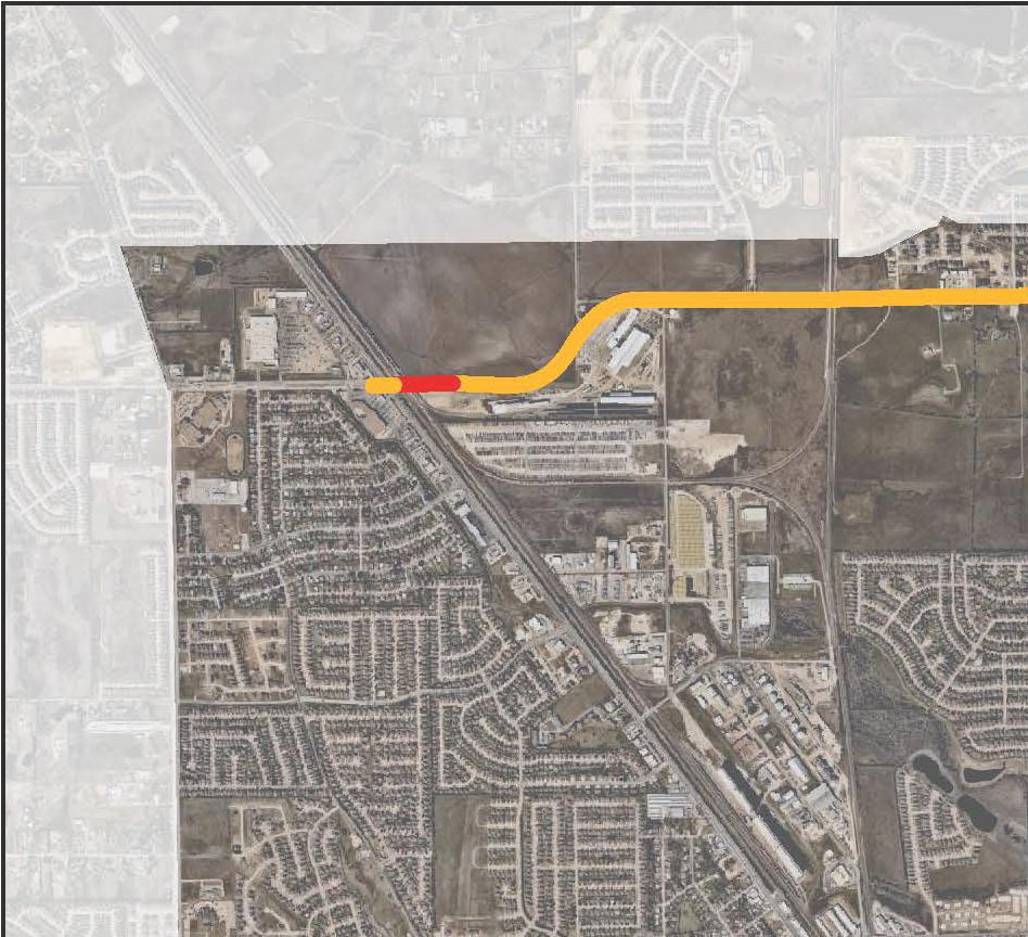
37 9) E. McLeroy Blvd. 1 Water Line S-Curve to FM 15 METHOD: Open-cut within future R.O.W. PROJECT COST: $550,000 This project is the third phase of a three phase project to provide improved transmission along East McLeroy Blvd. between Saginaw Blvd. and FM 15. This project cost assumes construction of the water line before or concurrent with construction of new development. This project does not account for installing water services for new residences. This project could be constructed by developers. 10) Basswood Blvd. 1 Water Line Bailey-Boswell Rd. to TXU Easement METHOD: Open-cut within future R.O.W. PROJECT COST: $540,000 This project would provide improved transmission between the Jarvis Road Elevated Tank and the east side of the City. This project cost assumes construction of the water line before or concurrent with construction of new development. This project does not account for installing water services for new residences. This project could be constructed by developers. 11) Heather Ridge Pkwy. 1" Water Line Heather Ridge Pkwy. to Basswood Blvd. METHOD: Open-cut within future R.O.W. PROJECT COST: $40,000 This project would provide improved transmission between the 1 transmission main in Basswood Blvd. and Heather Ridge Estates. This project cost assumes construction of the water line before or concurrent with construction of new development. This project does not account for installing water services for new residences. This project could be constructed by developers. 1) FM 15 1" Water Line Phase 450 Feet North of Topeka Dr. to Bailey Boswell Rd. METHOD: Open-cut PROJECT COST: $370,000 This project would connect transmission mains in Bailey Boswell with transmission mains along FM 15. This project cost assumes construction of the water line before or concurrent with construction of new development. This project does not account for installing water services for new residences. This project could be constructed by developers. City of Saginaw 01 Master Plan and CIP Page 35
38 13) Condor Trl. 1 Water Line Condor Trl. To Bailey Boswell Rd. METHOD: Open-cut PROJECT COST: $540,000 This project would connect transmission mains in Bailey Boswell with Heather Ridge Estates and provide distribution for any future development. This project cost assumes construction of the water line before or concurrent with construction of new development. This project does not account for installing water services for new residences. This project could be constructed by developers. 14) Defiel Rd. Water Line Defiel Rd. Cul-de-sac to Bailey Boswell Rd. METHOD: Open-cut PROJECT COST: $510,000 This project would connect dead end distribution lines along Defiel Rd. with transmission mains along Bailey Boswell. This line would provide future distribution along Defiel Rd. This project cost assumes construction of the water line before or concurrent with construction of new development. This project does not account for installing water services for new residences. This project could be constructed by developers. 15) Bailey Boswell Rd. 1" Water Line Loop Wagley Robertson Rd. to Bailey Boswell Rd. METHOD: Open-cut PROJECT COST: $50,000 This project would provide transmission for distribution lines for development on the undeveloped property on the northeast corner of Bailey Boswell Rd. and Saginaw Blvd. This project cost assumes construction of the water line before or concurrent with construction of new development. This project does not account for installing water services for new residences. This project could be constructed by developers. 1) Longhorn Rd. & Old Decatur Water Line Connection Landsdale Ln. to White Rock Dr. METHOD: Open-cut PROJECT COST: $340,000 This project would provide additional transmission and looping along Longhorn Rd. and Old Decatur. This project could be constructed by developers. City of Saginaw 01 Master Plan and CIP Page 3
39 Jarvis EST 1.5 Million Gallons Overflow = ' Head Range = 3' City of Fort Worth Meter Station 1 Longhorn Tanks and Pump Station Fort Worth Emergency Interconnect Park Center EST 0.75 Million Gallons Overflow = ' 1 Fort Worth Emergency Interconnect li Match ne li Match ne Legend. G Hydrant Water Facilities Water Lines by Size inch 4 inch inch inch 10 inch 1 inch 1 inch 4 inch EW City of Saginaw, Texas 01 Comprehensive Master Plan and CIP EXISTING WATER SYSTEM July 01 Map Disclaimer This map product is for informational purposes and may not have been prepared for or be suitable for legal, engineering, or surveying purposes. It does not represent an on-the-ground survey and represents only the approximate relative location of property boundaries.
40 FM 15 1 Bailey Boswell Road 15 7 Sa gi w Old Decatur Road na Bl vd E McLeroy Blvd 7 5 W McLeroy Blvd 1 1 Longhorn Road FM li Match 9 E Industrial Ave 7 ne li Match 1) ) 3) 4) 5) ) 7) ) 9) 10) 11) 1) 13) 14) 15) 1) Water CIP S. Hampshire 1" Water Line CDBG Bluebonnet Street " Water Line Saginaw Blvd. 1" Water Line Ph. Saginaw Blvd. 1" Water Line Ph. W. McLeroy 1" Water Line Ph. Old Decatur " Water Line Old Decatur 1" Water Line Ph. 1 Fort Worth Meter Station Upgrade East McLeroy Blvd. 1" Water Line Basswood Blvd. 1" Water Line Heather Ridge Pkwy. 1" Water Line FM 15 1" Water Line Ph. Condor Trail 1" Water Line Defiel Rd. " Water Line Bailey Boswell Rd. 1" Water Line Loop Longhorn Rd. & Old Decatur " Water Line Connection W City of Saginaw, Texas 01 Comprehensive Master Plan and CIP WATER CIP July 01 ne Map Disclaimer This map product is for informational purposes and may not have been prepared for or be suitable for legal, engineering, or surveying purposes. It does not represent an on-the-ground survey and represents only the approximate relative location of property boundaries.
41 III. Wastewater INTRODUCTION The purpose of this section is to update to update the system improvements and projected usage from the 011 Master Plan Update. The major items detailed in this Master Plan Update include: Identification of the existing collection system Historical and projected wastewater flows Determination of existing collection system capacity Plan for phased construction of facilities to meet projected flows This study supplies the information necessary to maintain adequate performance of the collection system through build out or the year 033. IDENTIFICATION OF THE EXISTING COLLECTION SYSTEM The existing sanitary sewer collection system consists entirely of gravity flow lines. There are currently no lift stations operated by the City of Saginaw. Saginaw owns no treatment facilities and relies solely on the City of Fort Worth to accept all of Saginaw's wastewater flows through four wastewater meter stations. The East Meter Station is east of FM 15 at Little Fossil Creek, the Southwest Meter Station is south of Longhorn Road at West Cement Creek, the Southeast Meter Station is located south of Longhorn Road at East Cement Creek, and the North Meter Station is located west of FM 15 at Big Fossil Creek. Exhibit EWW shows the existing wastewater collection system. The topography in Saginaw generally slopes from northwest to southeast. The City's wastewater system serves four separate drainage areas: Big Fossil Creek, Little Fossil Creek, East Cement Creek, and West Cement Creek. Line sizes range from " to 4" in diameter. Much of the system is less than 30 years old. The majority of the pipe materials are vitrified clay, PVC (polyvinyl chloride), and concrete. Generally, pipe installed within the last 0 years is PVC and pipe installed prior to that is vitrified clay. City of Saginaw 01 Master Plan and CIP Page 39
42 The system has been adequately maintained and operated with the exception of some infiltration/inflow (I/I) problems. HISTORICAL AND PROJECTED WASTEWATER FLOWS Accurate wastewater flow records are maintained from all four (4) metering stations. There are two main factors that affect wastewater volumes sent to Fort Worth, population and amount of precipitation. Population can be projected from year to year and generally increases within a predictable range. However, rainfall can vary greatly from year to year and it is difficult to accurately predict how much rainfall will occur in a given year. Wastewater volume projections are produced within a range, based on set rainfall amounts. Projections are divided into normal, wet, and dry ranges for a given year. Table 3.1 shows historical and projected average daily volumes. Wastewater volumes can be significantly higher during wet weather months as opposed to dry weather months. Wastewater volume is inversely proportional to water use. During dry, hot periods, water volumes are high due to the irrigation demand, but wastewater volumes are low due to lack of I/I entering the system. During wet periods, water demand is low because little or no irrigation is occurring; however, wastewater volumes increase significantly, perhaps three to four times average day volumes, because ground water gets into the collection system. Wastewater revenues are generated from water sales, based on a three month average of winter water use for December, January, and February. Therefore, under wet conditions, wastewater expenses can increase significantly while wastewater revenues remain the same. City of Saginaw 01 Master Plan and CIP Page 40

43 Wastewater Volume (MGD) HISTORICAL USE NORMAL YEAR USE WET YEAR USE DRY YEAR USE
44 INFILTRATION/INFLOW Flow in the wastewater collection system consists of three components: Base flow the total amount of wastewater discharged by the customer. Infiltration the water entering the collection system and private service lines from the ground, through defective pipe joints, broken pipes, cracks in manhole walls, and bad pipe-to-pipe and pipeto-manhole connections. Inflow the water entering the collection system and service lines from direct surface connections such as roof drains, yard drains, holes in manhole covers, etc. In 199, RJN Environmental prepared a flow monitoring report which indicated that Saginaw was experiencing I/I volumes as high as 1 million gallons per year. This was more than one-third of the annual volume of water purchased from The City of Fort Worth at that time. In 1995, the Saginaw Infiltration/Inflow Report was completed. The report prioritized twenty-six individual projects that would provide the most cost-effective reduction of I/I. The 1995, 000, 00, and 011 Capital Improvements Plans included a number of critical sewer rehabilitation projects. Additional I/I studies of select basins identified by City staff have been included in the current Capital Improvements Plan. The reductions of I/I has the following advantages: Increases available system capacity by decreasing the amount of extraneous flow transported by the collection system. Decreases charges from The City of Fort Worth by reducing total flow sent to The City of Fort Worth for treatment. Revenues remain constant. Therefore, reducing I/I has no effect on revenue generation, it only lowers operational costs. Reduces potential for future illegal overflows (overflows are costly to clean up and the TCEQ could levy fines). The City of Saginaw relies on The City of Fort Worth to treat its wastewater. Therefore the City does not have a National Pollution Discharge Elimination System (NPDES) permit to regulate discharges into the waters of the United States. An overflowing manhole is an unpermitted discharge and is subject to fines from The Environmental Protection Agency as well as the State of Texas. The City does not experience any illegal overflows so the incentive to decrease I/I is purely financial. City of Saginaw 01 Master Plan and CIP Page 4
45 The City of Fort Worth has increased the cost of treating wastewater for its wholesale customers, including the City of Saginaw. In order to reduce the cost of treating wastewater flows due to I/I, provide additional capacity, and replace aging infrastructure, several major capital improvement projects are recommended in this Master Plan update CAPITAL IMPROVEMENTS PLAN WASTEWATER From the Master Planning process, a recommended plan of Capital improvements has been developed. This Capital Improvements Plan is divided into five years. The primary purpose of the recommended improvements is to maintain or improve the existing level of service. The wastewater collection system should be a high priority for the City of Saginaw over the next five years. Updated I/I work is recommended to identify the areas of the collection system that are contributing the most to the increased flow. Several lines identified in this study are associated with future development and several are anticipated to decrease the I/I flows. These improvements are identified below. Exhibit WW shows all improvements for the wastewater system. CAPITAL IMPROVEMENTS PROJECTS 1) Blue Ridge Trl. Sanitary Sewer Longhorn Rd. to Mesa Ct. METHOD: Trenchless PROJECT COST: $0,000 This line was identified for replacement due to pipeline deterioration and infiltration/inflow problems. Replacing the line using a pipe bursting method will increase the pipe capacity with minimum disruption to the neighborhood. ) S.W. 1 Trunk Main Replacement Longhorn Rd. to Sky Wood Ct. METHOD: Open Cut PROJECT COST: $500,000 This will provide additional capacity to the major trunk main serving all of the West Cement Creek Basin. 3) Fairmount 1 Sanitary Sewer Rehabilitation Southern Ave. to Sansom Blvd. METHOD: Bore PROJECT COST: $,090,000 This line was identified for replacement due to pipeline deterioration and infiltration/inflow problems. Replacing the new line by bore will minimize disturbance to railroad and industrial activities. City of Saginaw 01 Master Plan and CIP Page 43
46 4) Infiltration / Inflow (I/I) Study, Phase 1 Continued Little Fossil Creek PROJECT COST: $40,000 A study, including smoke testing and manhole inspections, was performed on a selected area of the Little Fossil Creek Basin in 01. The study identified numerous sections of pipe for further analysis. The continuation of this study will include television inspection of approximately 14,500 LF of pipe. This study will recommend projects to address the most critical I/I problem areas. 5) Infiltration / Inflow (I/I) Study, Phase West Cement Creek Basin PROJECT COST: $95,000 This study will include flow monitoring and identification of problem sections. This study will include smoke testing and television inspection of selected sections. This study will recommend projects to address the most critical I/I problem areas. ) Infiltration / Inflow (I/I) Study, Phase 3 East Cement Creek Basin PROJECT COST: $95,000 This study will include flow monitoring and identification of problem sections. This study will include smoke testing and television inspection of selected sections. This study will recommend projects to address the most critical I/I problem areas. 7) Infiltration / Inflow (I/I) Study, Phase 4 Big Fossil Creek Basin PROJECT COST: $95,000 This study will include flow monitoring and identification of problem sections. This study will include smoke testing and television inspection of selected sections. This study will recommend projects to address the most critical I/I problem areas. ) Redding Dr. " Sanitary Sewer Extension Mockingbird Dr. to Heather Ridge Pkwy. METHOD: Open Cut PROJECT COST: $30,000 The purpose of this project is to provide sewer service to new development. This project cost assumes construction of the sewer line before or concurrent with construction of new development. This project does not account for installing sewer services for new residences. This project could be constructed by developers. City of Saginaw 01 Master Plan and CIP Page 44
47 9) Cheyenne Ct. 1" Sanitary Sewer Extension Cheyenne Ct. to Future Redding Dr. METHOD: Open Cut PROJECT COST: $40,000 The purpose of this project is to provide sewer service to new development. This project cost assumes construction of the sewer line before or concurrent with construction of new development. This project does not account for installing sewer services for new residences. This project could be constructed by developers. 10) Bailey Boswell 1" Sanitary Sewer Extension Jarvis Rd. to Saginaw Blvd. METHOD: Bore and Open Cut PROJECT COST: $770,000 The purpose of this project is to provide sewer service to new development along Bailey Boswell. This project cost assumes construction of the sewer line before or concurrent with construction of new development. This project does not account for installing sewer services for new residences. This project could be constructed by developers. City of Saginaw 01 Master Plan and CIP Page 45

 10 Southeast Meter Station 10 1 1 10 10 1 1 1 7 1 1 1 1 1 1 1 15 E Industrial")


48 Old Decatur Road 7 Bailey Boswell Road North Meter Station Big Fossil Little Creek Fossil Creek East West Cement Cement E McLeroy Blvd Creek Creek East Meter Station inch W McLeroy Blvd 1 Longhorn Road ") 1 1 Saginaw Blvd 1 Southwest Meter Station ") 10 Southeast Meter Station E Industrial Ave ") ") FM 15 FM 15 1 Matchline Legend ") Meter Stations Manholes Sewer Lines by Size 4 inch inch inch 10 inch 1 inch 15 inch 1 inch 4 inch Matchline EWW City of Saginaw, Texas 01 Comprehensive Master Plan and CIP EXISTING WASTEWATER SYSTEM July 01 Map Disclaimer This map product is for informational purposes and may not have been prepared for or be suitable for legal, engineering, or surveying purposes. It does not represent an on-the-ground survey and represents only the approximate relative location of property boundaries.
 ) 3) 4) 5) ) 7) ) 9) 10) 01-01 Wa")
49 1 li Match 3 Little Fossil Creek East Cement Creek West Cement Creek Big Fossil 9 Creek 10 ne line Match 1) ) 3) 4) 5) ) 7) ) 9) 10) Wastewater CIP Blue Ridge Trl. " Sanitary Sewer S.W. 1" Trunk Main Replacement Fairmont 1" Sanitary Sewer Rehabilitation I&I Study Phase 1 - Continued I&I Study Phase I&I Study Phase 3 I&I Study Phase 4 Redding Dr. " Sanitary Sewer Extension Cheyenne Ct. 1" Sanitary Sewer Extension Bailey Boswell 1" Sanitary Sewer Extension WW City of Saginaw, Texas 01 Comprehensive Master Plan and CIP WASTEWATER CIP July 01 Map Disclaimer This map product is for informational purposes and may not have been prepared for or be suitable for legal, engineering, or surveying purposes. It does not represent an on-the-ground survey and represents only the approximate relative location of property boundaries.
50 IV. Streets INTRODUCTION The purpose of this section is to update the improvements and projected projects from the 011 Master Plan Update. MASTER THOROUGHFARE PLAN This Master Plan Update includes a thoroughfare plan that was coordinated with the City of Fort Worth and the North Central Texas Council of Governments Regional Master Thoroughfare Plan. The thoroughfare plan is a primary source of information for review of subdivision plats and zoning change cases; dedication of rights-of-way (ROW) for development of principal and minor arterials and collectors; preparation of traffic impact studies; development of new land use plans; and preparation of the Capital Improvements Plan. The Master Thoroughfare Plan is a significant component of the City's Master Plan. It provides for an efficient and economical roadway network, and allows for the orderly coordination of both public and private roadway improvements. The plan provides mobility through a network of public streets that offers access to private and public properties. The plan shows the major roadway system for both the fully developed and the undeveloped areas of the City. Ultimate development of roadways depends on actual demands, developers' initiatives, regional needs, and availability of capital resources. In undeveloped areas, the proposed alignments are general and approximate. Actual alignments will be formalized as development based on topography, economic viability, actual street configuration, and opportunities for right-of-way dedication takes place. The Master Thoroughfare Plan is made up of the following elements: principal arterials, minor arterials and collectors. Principal arterials carry significant regional travel between urban and suburban centers of activity. Minor arterials interconnect with and augment the principal arterial system. Collectors are customarily constructed as development occurs based on site planning and traffic needs of specific site locations. City of Saginaw 01 Master Plan and CIP Page 4
51 The location of each Master Thoroughfare Plan element is based on existing roadways, approved plans and programs for realignment and extension, approved concept plans, preliminary plats, and final plats. Roadway locations also are developed with special attention to existing natural features, topography, waterways, and flood-prone areas. Existing manmade features such as railroads, roadways, major utility lines and facilities, existing developments and property lines are also considered. Exhibit MTP is the proposed Master Thoroughfare Plan. FUNCTIONAL CLASSIFICATION OF THE ROADWAY SYSTEM The concept of a roadway system with a street hierarchy, where each category places a different emphasis on traffic mobility and property access, is well established. Each classification of roadway serves a specific function, with all the types, taken together, providing a balance of opportunities for mobility and land access. PRINCIPAL ARTERIAL The main function of a principal arterial is to carry regional traffic from one urban area to another. The principal arterial street system also serves the major activity centers of an urbanized area. The principal arterial is used for longer urban trips and carries a high proportion of the total area s traffic. The principal arterial street system carries most of the traffic entering and leaving the urban area as well as most of the trips passing through the city. Principal arterials are designed to carry over 3,000 vehicles per day and are intended to serve high-density residential, retail, service and industrial uses. The recommended right-of-way for Saginaw s principal arterial streets is 10 feet. MINOR ARTERIAL The minor arterial street system connects with and expands the principal arterial system to accommodate trips of moderate length with a somewhat lower level of travel mobility and a higher level of land access than the principal arterial system. The system distributes travel to geographic areas smaller than those assigned with the principal arterials. Minor arterials may be four-lane divided or undivided roads, or five lanes with the center lane designated for left turns. Such facilities may carry local bus routes and provide inter-community continuity, but should not penetrate identifiable neighborhoods. Minor arterials are designed to carry 4,000-3,000 vehicles per day. The recommended right-of-way for Saginaw s minor arterial streets is 100 feet. City of Saginaw 01 Master Plan and CIP Page 49
52 COLLECTOR A collector street s primary function is to collect and distribute traffic from local access streets to the arterial or major streets. These streets move moderate amounts of traffic volumes and provide limited access to adjacent properties. Collectors supplement the arterial system and should not be continuous for long distances. The collector street is usually located in a manner to discourage through-traffic movements. This is accomplished by the disruption of traffic flow by offsetting intersections and by incorporating curvilinear design. The recommended right-of-way for Saginaw s minor arterial streets is 0 feet. DESIGN STANDARDS FOR ROADWAY SYSTEM The following are design criteria to be used in the design of each roadway to serve the expected traffic volume and provide consistency and uniformity in traffic operations (see Table 4.1). TABLE 4.1 DESIGN CRITERIA Street Classification Principal Arterial Minor Arterial Designation Minimum Right- of- Way Minimum Roadway Width No. of Lanes and Width Parking Lanes and Width Median Width Parkway Width Sidewalks Required PD 10' () 3' lanes - 1' None 0' 14' - Yes M4D 100' () ' -1' & -14' None 0' 14' - Yes M4U ' 4' 4 lanes - 1' None None 14' - Yes Collector C 0' 40' -1' & -' - ' None 10' - Yes Local B NA 5' 3' -10' & -' - ' None 10' - Yes Local A NA 50' 30' 1-14' & -' - ' None 11' - Yes Limited Local NA 40' 4' 3 - ' - ' None ' - Yes Additional right-of-way will be required at most intersections and may be required at high-volume driveways to provide left and right turn lanes to maintain traffic volume capacities through the intersections. Also, additional utility easements may be required beyond the right-of-way. RIGHT-OF-WAY DEDICATION Right-of-Way (ROW) refers to the width in feet necessary to construct the roadway, medians, parking lanes, sidewalks and utilities. All principal arterials will require 10 feet of ROW and minor arterials will have or 100 feet of ROW. Whether the roadway is divided or undivided, the ROW specified per classification must be dedicated during preliminary and final platting. If the roadway is a border street, City of Saginaw 01 Master Plan and CIP Page 50
53 each adjacent owner is expected to dedicate up to the centerline, or one-half of the required ROW. Additional ROW will be required at most intersections to provide left and right turn lanes to maintain traffic volume capacities through the intersections. IMPLEMENTATION Implementation of the road network plan can be completed either through construction of capital improvement projects by the City or through developer constructed projects. When roadway infrastructure is adjacent to or traveling through a developing parcel, the developer can be required to build roadway infrastructure in accordance with the City s Master Thoroughfare Plan. The City intends that a developer be required only to build, construct, dedicate or fund improvements necessary to address the roughly proportional share of the cost or impact of the proposed development to the offsite or adjacent roadway. This policy is consistent with improvements required in Section 1.15 Improvements Required of the City s subdivision ordinance. STREET MAINTENANCE The City of Saginaw currently maintains over 95 miles of streets. Most of the older streets were constructed of asphalt, but the newer streets are constructed with concrete. The streets include approximately the same number of miles of asphalt and concrete streets. Recently, growth has resulted in the extensive construction of concrete streets, which will require significantly less maintenance than the asphalt streets. Routine replacement or rehabilitation of existing streets, particularly the asphalt roads, will be required to protect the City s investment in its roadway infrastructure. There are four methods used for rehabilitating or maintaining streets: Reconstruction removing the asphalt or concrete pavement, treating the road base, and then repaving with either new asphalt or concrete pavement. Reclamation mixing the existing asphalt and road base together and adding cement or lime stabilization. Once the new base is stabilized and compacted, then the street is repaved with new asphalt. This approach has provided tremendous value to the city and its street maintenance program. Mill and Overlay Cracks in the asphalt pavement accelerate the deterioration of the pavement. The cracks allow water to seep into the base, thereby weakening the base s ability to support the asphalt pavement. Whenever the asphalt pavement has aged and developed a serious crack problem, then we evaluate the road s condition to determine the following: City of Saginaw 01 Master Plan and CIP Page 51
54 If the asphalt and the base have failed, then the road needs to be reclaimed. If the road base is adequate and the asphalt has minor deterioration, then the road can be milled and overlaid. A milling machine is used to remove 1 to inches of asphalt at the concrete gutter line and is tapered out four to eight feet from the gutter. This provides a good tie-in point at the gutter line for the asphalt overlay. Milling and overlaying a street is a cost-effective method of extending the life of an existing roadway. Seal Coating Cracks in the asphalt pavement accelerate the deterioration of the pavement. The cracks allow water to seep into the base, thereby weakening the base's ability to support the asphalt pavement. Whenever the asphalt pavement has aged and developed a serious crack problem, then we evaluate the road's condition to determine the following: If the asphalt and the base have failed, then the road needs to be reconstructed or reclaimed. If the road base is adequate and the asphalt only suffers from minor cracking, then the road is a good candidate for seal coating. Seal coating is the placement of a bituminous binder on the entire surface area of the pavement. The coating seals the cracks and prevents water from penetrating into the base. The bituminous binder itself does not provide a good driving surface; therefore a small aggregate (rock) is evenly spread over the bituminous binder to provide a better driving surface. Crack Sealing an important maintenance procedure that involves sealing cracks that form in asphalt or concrete pavement. Cracks in the pavement allow moisture to penetrate into the subgrade and weaken it. If too many cracks are left unattended they can lead to accelerated failure of the pavement. City of Saginaw 01 Master Plan and CIP Page 5
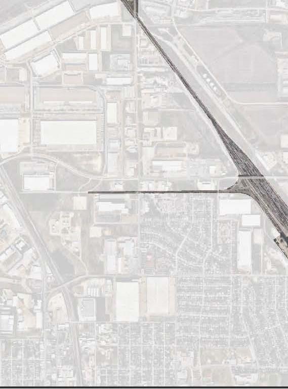
55 01 01 CAPITAL IMPROVEMENTS PLAN STREETS The following recommended plan for street improvements was developed in close coordination with City staff. The projects are distributed over the five years of the Capital Improvements Plan and are scheduled to address the most critical needs first. Exhibit S indicates the proposed street improvements. CAPTIAL IMPROVEMENTS PROJECTS 1) Bailey Boswell Phase & 3 Reconstruction Saginaw Blvd. to approximately 500 feet west of Ash Meadow Dr. METHOD: Reconstruction PROJECT COST: $14,0,000 This project consists of the reconstruction of Bailey Boswell to the ultimate section requirements identified on the City s Master Thoroughfare Plan, -lane divided. ) Bailey Boswell Overpass Intersection of Bailey Boswell and Saginaw Blvd. METHOD: New Construction PROJECT COST: $10,01,950 This project consists of the construction of an overpass to elevate Bailey Boswell over the railroad tracks and Saginaw Blvd. to the commercial developments on the west side. 3) Basswood Blvd. Woodcrest Development to Bailey Boswell Rd. METHOD: New Construction PROJECT COST: $3,00,000 This project consists of the construction of lanes of Basswood Blvd. for 400 feet and the construction of 4 lanes of Basswood Blvd. for 1,700 feet. lanes will initially be constructed by the developer as a part of the Woodcrest Development. The construction of the remaining lanes at a later date will complete the full 4-lane section. From this point in the Woodcrest Development, a 4 lane section of Basswood Blvd. will be constructed to Bailey Boswell Rd. at a later date. It is likely that the City will have to cost participate in this project. 4) E. McLeroy Blvd. Phase Reconstruction Saginaw Blvd. to S-Curve METHOD: Reconstruction PROJECT COST: $10,400,000 This project will complete an important principal arterial connection from Old Decatur Rd. to Western Center Blvd. This project should be closely coordinated with TxDOT. City of Saginaw 01 Master Plan and CIP Page 53
56 5) W. McLeroy Blvd. Phase 3 Reconstruction Saginaw Blvd. to Knowles Dr. METHOD: Reconstruction PROJECT COST: $,500,000 This project will complete an important minor arterial connection from Old Decatur Rd. to Western Center Blvd. This project should be closely coordinated with TxDOT. ) W. McLeroy Blvd. Phase 4 Reconstruction Old Decatur Rd. to Knowles Dr. METHOD: Reconstruction PROJECT COST: $5,00,000 This project will complete an important minor arterial connection from Old Decatur Rd. to Western Center Blvd. 7) Knowles Dr. Phase 1 Reconstruction to 3 Lanes Longhorn Rd. to W. McLeroy Blvd. METHOD: Reconstruction PROJECT COST: $3,400,000 Construction of a 3-lane minor arterial roadway as identified in the Master Thoroughfare Plan and associated drainage improvements. ) Knowles Dr. Phase A Reconstruction to 3 Lanes W. McLeroy Blvd. to Woodcrest Dr. METHOD: Reconstruction PROJECT COST: $,500,000 Construction of a 3-lane minor arterial roadway as identified in the Master Thoroughfare Plan and associated drainage improvements. 9) Knowles Dr. Phase B Reconstruction to 3 Lanes & Drainage Improvements Woodcrest Dr. to W.J. Boaz Rd. METHOD: Reconstruction PROJECT COST: $4,90,000 Construction of a 3-lane minor arterial roadway as identified in the Master Thoroughfare Plan and construction of major drainage improvements to fix existing drainage issues along Leatherman Dr. 10) Knowles Dr. Phase 3 Reconstruction to 3 Lanes W.J. Boaz Rd. to Normandy Ln. METHOD: Reconstruction PROJECT COST: $1,0,000 Construction of a 3-lane collector roadway as identified in the Master Thoroughfare Plan and associated drainage improvements. City of Saginaw 01 Master Plan and CIP Page 54
57 11) W.J. Boaz Old Decatur Rd. to Knowles Dr. METHOD: New Construction PROJECT COST: $50,000 This project consists of the construction of W.J. Boaz from the existing -lane section to ultimate 4-lane section from Old Decatur Rd. to Knowles Dr. 1) Industrial Blvd. Reconstruction 1000 East of Saginaw Blvd. to FM 15 METHOD: Reconstruction PROJECT COST: $4,00,000 Construction of a 4-lane divided roadway and associated drainage and railroad crossing improvements. 13) Railroad Quiet Zone Study Implementation Multiple Railroad Crossings within City Limits METHOD: Study and Implementation PROJECT COST: $0,000 Study and Implementation of Railroad Quiet Zones. 14) Heather Ridge Pkwy. Extension 400' North of Raven Dr. to Woodcrest Development METHOD: New Construction PROJECT COST: $1,000,000 Construction of a -lane undivided roadway and associated drainage improvements. This project could be constructed by developers. 15) E. McLeroy Blvd. (Western Center Extension) FM 15 to S-Curve METHOD: New Construction PROJECT COST: $4,100,000 This project will complete an important principal arterial connection to Western Center Blvd. This project should be closely coordinated with TxDOT and the City of Fort Worth. This project could be constructed by developers. City of Saginaw 01 Master Plan and CIP Page 55


58 M4D M4D C M4D C C P4D P4D C C P4D P4D M3U 7 P4D P4D PD Bailey Boswell Road PD PD PD C C C PD PD M4U Saginaw Blvd PD C C C C PD FM 15 Old Decatur Road L C M3U PD M4D M4D C C P4D E McLeroy Blvd W McLeroy Blvd FM 15 M4D M4D M4D M3U Longhorn Road PD C3U E Industrial Ave 7 P4D Matchline Matchline Saginaw Master Thoroughfares C- Collector M - Minor Arterial P - Principal Arterial L - Local Street Surrounding Thoroughfares Freeway Principal Arterial Major Arterial Minor Arterial MTP City of Saginaw, Texas 01 Comprehensive Master Plan and CIP MASTER THOROUGHFARE PLAN July 01 Map Disclaimer This map product is for informational purposes and may not have been prepared for or be suitable for legal, engineering, or surveying purposes. It does not represent an on-the-ground survey and represents only the approximate relative location of property boundaries.
 10) 11) 1) 13) 14) 15) 01-01 Street CIP Bailey Boswell Ph. & 3 Reconstruction Bailey Boswell Overpass Basswood Blvd. E. McLeroy Blvd. Ph. Reconstruction W. McLeroy Blvd. Ph. 3 Reconstruction W.")
59 Bailey Boswell Road 3 FM Sa Bl vd E McLeroy Blvd 5 FM 15 W McLeroy Blvd 4 15 w 11 na Old Decatur Road gi 9 7 E Industrial Ave Longhorn Road 1 7 li Match ne li Match 1) ) 3) 4) 5) ) 7) ) 9) 10) 11) 1) 13) 14) 15) Street CIP Bailey Boswell Ph. & 3 Reconstruction Bailey Boswell Overpass Basswood Blvd. E. McLeroy Blvd. Ph. Reconstruction W. McLeroy Blvd. Ph. 3 Reconstruction W. McLeroy Blvd. Ph. 4 Reconstruction Knowles Dr. Ph. 1 Reconstruction to 3 Lanes Knowles Dr. Ph. A Reconstruction to 3 Lanes Knowles Dr. Ph. B Reconstruction to 3 Lanes and Drainage Improvements Knowles Dr. Ph. 3 Reconstruction to 3 Lanes W.J. Boaz Industrial Blvd. Reconstruction Railroad Quiet Zone Implementation (Location TBD) Heather Ridge Pkwy. Extension E. McLeroy Blvd. (Western Center Extension) S City of Saginaw, Texas 01 Comprehensive Master Plan and CIP STREET CIP July 01 ne Map Disclaimer This map product is for informational purposes and may not have been prepared for or be suitable for legal, engineering, or surveying purposes. It does not represent an on-the-ground survey and represents only the approximate relative location of property boundaries.
60 V. Drainage INTRODUCTION The purpose of this section is to update the improvements and projected projects from the 011 Master Plan Update. This section includes: A review of recommendations made in the 199 Comprehensive Master Plan and the 1995, 000, 00, and 011 Master Plan Updates to confirm that the assumptions made are still valid A review of improvements that have been constructed Recommendations for this Five Year Capital Improvements Plan BACKGROUND The City of Saginaw is divided into four drainage basins, which are described in detail in the 199 Comprehensive Master Plan. Big Fossil Creek 1,040 acres Little Fossil Creek,70 acres East Cement Creek 470 acres West Cement Creek 70 acres Saginaw receives no contributions to its drainage system from outside the City except for the Big Fossil Creek Basin, a large, regional drainage basin that clips the northeast corner of the City. Most of the basins drainage problems are due to the challenge of passing water under Saginaw Blvd. and the parallel railroad tracks. City of Saginaw 01 Master Plan and CIP Page 5
61 REVIEW OF DESIGN ASSUMPTIONS Design assumptions that impact drainage design are existing land use and anticipated ultimate land use. A more intense land use will produce more runoff and a less intense land use will produce less runoff. Rapid growth can necessitate the acceleration of some of the needed drainage infrastructure improvements. REVIEW OF IMPROVEMENTS Of the improvements recommended in the 199 Comprehensive Master Plan and 1995 Master Plan Update, two major improvements have been completed: Saginaw Blvd. Drainage System #1 Saginaw Blvd. Drainage System # Phases I-V (Channel improvements to Northern Ave.) East Cement Creek Improvements Phase 1 (Opal Street Culverts) The completion of these improvements was a significant accomplishment. These projects were two of the most expensive and challenging projects in the 199 and 1995 Capital Improvements Plans. The completion of System #1 and System # Phases I-V were critical to the implementation of the City s Drainage Master Plan. System #3 and Phases VI VII (Lemon to Minton) of System # are the last major systems to be implemented in order to complete the primary elements of the City s ultimate Drainage Master Plan CAPITAL IMPROVEMENTS PLAN DRAINAGE This five year Capital Improvements Plan is a continuation of the improvements recommended in previous plans. The majority of the projects in this CIP concentrate on moving storm water from west to east across Saginaw Blvd. and the railroad tracks. The five year plan is scheduled to address the most critical needs first. Exhibit D indicates all proposed improvements. Due to the cost of the Saginaw Blvd. Drainage System #3, necessary coordination with TxDOT, and the length of time it will take to construct, the project will be not be addressed during this 5-year plan. City of Saginaw 01 Master Plan and CIP Page 59
62 CAPITAL IMPROVEMENTS PROJECTS DRAINAGE 1) East Cement Creek Drainage Improvements (Survey and Engineering) Opal Street to West McLeroy Blvd. PROJECT COST: $45,000 This project may need to be accelerated based on flooding issues in East Cement Creek Drainage Basin. a) East Cement Creek Drainage Improvements Phase Channel Improvements Opal St. to Blue Ridge Tr., Blue Ridge Drainage Improvements PROJECT COST: $1,00,000 This project may need to be accelerated based on flooding issues in East Cement Creek Drainage Basin. b) East Cement Creek Drainage Improvements Phase 3 Channel Improvements Blue Ridge Trl. to W. McLeroy Blvd., Culvert at W. McLeroy Blvd. PROJECT COST: $1,30,000 This project may need to be accelerated based on flooding issues in East Cement Creek Drainage Basin. 3) Meadow Street Ditch Improvements Channel behind homes on Meadow Dr. from approximately Fenway Ln. to Knowles Dr. PROJECT COST: $75,000 This project will fill in an existing grass channel and will pipe the existing flow. This project will fix an existing drainage issue and eliminate maintenance of the existing channel. 4) Saginaw Blvd. Drainage System # - Phase VI and VII Northern to Cambridge (Phase V), Cambridge to Minton (Phase VI) PROJECT COST: $,75,000 This project is the last phase required to complete system #. Design has been completed. Easement acquisition and utility relocation have not been completed. City of Saginaw 01 Master Plan and CIP Page 0
63 5) Saginaw Blvd. Drainage System #3 Saginaw Blvd. to FM 15 PROJECT COST: $,90,000 This project improves the drainage along Saginaw Blvd. between McLeroy Blvd. and Longhorn Blvd. The project consists of earthen channel from FM 15 to the BNSF railroad, crossing under and proceeding along the west side of the railroad. The improvements then turn westward, crossing under the Union Pacific and BNSF Railroads, and proceeding across Saginaw Blvd. A main line will extend to the north, from Saginaw Blvd., along the West side of Saginaw Blvd. to Green Ave. Another main line will be extended to the south to Hialeah Park. City of Saginaw 01 Master Plan and CIP Page 1
64 7 Bailey Boswell Road Big Fossil Creek 3 FM 15 Little Fossil Creek Sa na w Bl vd E McLeroy Blvd 5 a FM 15 b W McLeroy Blvd Old Decatur Road gi West Cement Creek East Cement Creek 4 E Industrial Ave Longhorn Road 7 li Match ne li Match 1) a) b) 3) 4) 5) ne Drainage CIP East Cement Creek Improvements (Survey and Engineering) East Cement Creek Improvements - Phase East Cement Creek Improvements - Phase 3 Meadow Street Ditch Improvements Saginaw Blvd. System # - Phase VI, VII Saginaw Blvd. System #3 D City of Saginaw, Texas 01 Comprehensive Master Plan and CIP DRAINAGE CIP July 01 This map product is for informational purposes and may not have been prepared for or be suitable for legal, engineering, or surveying purposes. It does not represent an on-the-ground survey and represents only the approximate relative location of property boundaries.
65 VI. Community Facilities INTRODUCTION The purpose of this section is to update the community facilities section that was part of Saginaw s 011 Master Plan Update. Community Facilities are defined as the municipal buildings and recreation areas required to provide City services and recreation. A separate study, completed in 014, titled Saginaw Parks, Recreation, and Open Space Vision 05, studied the City s Parks and Open Spaces. Additional facilities that have been studied on past Master Plans and this Master Plan Update includes: City Hall Police Fire Library Animal Control Service Center (Public Works) Senior Citizens Center Parks UNDEVELOPABLE LAND New development that contains portions of land that will not be able to be developed due to designated floodplain or other restrictions should be considered for park use. Portions of land designated for park use should be granted to the City through the platting process. Exhibit CF indicates all proposed improvements. The following is a summary of the proposed community facility projects scheduled to occur within this five year plan and beyond: City of Saginaw 01 Master Plan and CIP Page 3
66 CAPTIAL IMPROVEMENTS PROJECTS 1) Public Works Facility PROJECT COST: Unknown Construction of new public works building adjacent to existing public works building. ) Americans with Disability Act Transition Plan City Limits PROJECT COST: $31,000 This plan would include a review of the current programs, procedures, and policies related to the activities and services available to the public and any barriers to access. This plan would also include an evaluation of park infrastructure, City buildings, intersections, and sidewalks. 3) City Hall Parking Lot Expansion PROJECT COST: $30,000 Expansion of the existing parking lot north to W. McLeroy Blvd. This project would include sidewalk, irrigation, and lighting improvements. 4) Recreation Center Expansion PROJECT COST: Unknown The existing recreation center facilities are in need of updating for space and use improvements. 5) Library Expansion / Satellite Annex PROJECT COST: Unknown The existing Library facilities are in need of updating for space and technological improvements. The satellite annex would provide library services to residents in another area of the City. ) Softball / Baseball Complex PROJECT COST: Unknown If we were to acquire 50 acres, we could construct a four-plex for adult play and fields for youth baseball and softball and possibly have room for soccer fields or practice fields. City of Saginaw 01 Master Plan and CIP Page 4

 3) 4) 5) ) ne 01-01 Community Facilities CIP Public")


67 7 Bailey Boswell Road Sa FM 15 1 gi w Old Decatur Road na Bl vd 3,5 4 FM 15 W McLeroy Blvd E McLeroy Blvd E Industrial Ave Longhorn Road 7 li Match ne li Match 1) ) 3) 4) 5) ) ne Community Facilities CIP Public Works Remodel Americans with Disability Act Transition Plan City Hall Parking Lot Expansion Recreation Center Expansion Library Expansion / Satellite Annex Softball / Baseball Complex CF City of Saginaw, Texas 01 Comprehensive Master Plan and CIP COMMUNITY FACILITIES CIP July 01 This map product is for informational purposes and may not have been prepared for or be suitable for legal, engineering, or surveying purposes. It does not represent an on-the-ground survey and represents only the approximate relative location of property boundaries.
Brevard County Utility Services Department
 Brevard County Utility Services Department April 3, 2018 Jim Helmer, Department Director Brian Sorensen, W/WW Manager 1 Utility Services Department 9 TREATMENT PLANTS 6 WASTEWATER, 3 WATER 163 EMPLOYEES
Parkland County Municipal Development Plan Amendment Acheson Industrial Area Structure Plan
 Parkland County Municipal Development Plan Amendment Acheson Industrial Area Structure Plan New Plan Acheson Industrial Area Structure Plan Amendment Parkland County Municipal Development Plan Board Reference
Airport Planning Area
 PLANNING AREA POLICIES l AIRPORT Airport Planning Area LOCATION AND CONTEXT The Airport Planning Area ( Airport area ) is a key part of Boise s economy and transportation network; it features a multi-purpose
BOND PROGRAMS PROJECTS SCHEDULE AND DELIVERY
 BOND PROGRAMS PROJECTS SCHEDULE AND DELIVERY Presented to the City Council By the City Manager s Office May 10, 2016 1 Topics Update on Projects From Previous Bond Programs Prior to 2014 2014 Bond Program
CHAPTER 6 NOISE EXPOSURE
 CHAPTER 6 NOISE EXPOSURE FAA requires that the NEM submitted for review represent the aircraft noise exposure for the year of submittal (in this case 2008) and for a future year (2013 for OSUA). However,
Lake Erie Commerce Center Traffic Analysis
 LOCATION: East of NYS Route 5 at Bayview Road Town of Hamburg Erie County, New York PREPARED BY: Wendel Companies 140 John James Audubon Parkway Suite 200 Amherst, New York 14228 January 2012 i ii Table
2013 Regional Water System Improvements Program Public Hearing March 14, 2013
 In support of Illinois Environmental Protection Agency State Revolving Fund Loan Application 2013 Regional Water System Improvements Program Public Hearing March 14, 2013 Village of Oak Lawn Customer Communities:
SUMMER VILLAGE OF SILVER SANDS. Municipal Development Plan
 SUMMER VILLAGE OF SILVER SANDS Municipal Development Plan Bylaw 253-2014 Adopted August 22, 2014 Summer Village of Silver Sands Municipal Development Plan Bylaw No. 253-2014 Page 2 1 INTRODUCTION 1.1 SETTING
Tinker Air Force Base, Oklahoma
 Table 5.4 Generalized Zoning within the Tinker AFB Clear Zones and Accident Potential Zones (Off-Installation) Category Acreage Residential 1,486 Commercial 191 Industrial 128 Public/Quasi-public 0 Recreational/Open/Agricultural/Low
FORECASTING FUTURE ACTIVITY
 EXECUTIVE SUMMARY The Eagle County Regional Airport (EGE) is known as a gateway into the heart of the Colorado Rocky Mountains, providing access to some of the nation s top ski resort towns (Vail, Beaver
Appendix E. System Issues
 Appendix E System Contents Page System... E-1 E.1 Introduction...E-1 E.2 Existing Model - System...E-2 E.2.1 Location: Country Ridge Collector, at Queensgate Drive...E-2 E.3 Committed Model - System...E-3
DRAFT GENERAL IMPLEMENTATION PLAN AND SPECIFIC IMPLEMENTATION PLAN MIDDLETON MUNICIPAL AIRPORT MOREY FIELD. Revised 12/12/03
 DRAFT GENERAL IMPLEMENTATION PLAN AND SPECIFIC IMPLEMENTATION PLAN MIDDLETON MUNICIPAL AIRPORT MOREY FIELD Revised 12/12/03 As recommended for approval by the Plan Commission General Project Description
Vista Field Airport. Master Plan Update. February, Prepared for: Port of Kennewick One Clover Island Kennewick, Washington
 Vista Field Airport February, 2006 Prepared for: Port of Kennewick One Clover Island Kennewick, Washington 99336 Prepared by: J-U-B ENGINEERS, Inc. 2810 W. Clearwater Avenue, Suite 201 Kennewick, Washington
Westover Metropolitan Airport Master Plan Update
 Westover Metropolitan Airport Master Plan Update June 2008 INTRODUCTION Westover Metropolitan Airport (CEF) comprises the civilian portion of a joint-use facility located in Chicopee, Massachusetts. The
Bloor Street West Rezoning Application for a Temporary Use By-law Final Report
 STAFF REPORT ACTION REQUIRED 3741 3751 Bloor Street West Rezoning Application for a Temporary Use By-law Final Report Date: June 12, 2007 To: From: Wards: Reference Number: Etobicoke York Community Council
Section 106 Update Memo #1 Attachment D. Traffic Diversion & APE Expansion Methodology & Maps
 Section 106 Update Memo #1 Attachment D Traffic Diversion & APE Expansion Methodology & Maps I-65/I-70 North Split Interchange Reconstruction Project (Des. Nos. 1592385 & 1600808) Traffic Diversion and
June 2013: Capital Improvements Update. through $ 126,196,202 Available Funding through 2018 $ 149,783,656. Staff s Recommendation
 Capital Improvements Update June 2013: Pl dp j t Planned Projects through 2018 - $ 126,196,202 Available Funding through 2018 $ 149,783,656 pp p,, Un-appropriated - $ 23,587,454 Staff s Recommendation
Why are the underground fuel tanks being removed and replaced with above ground tanks?
 AIRPORT/CITIZEN FAQ This list of Frequently Asked Questions (FAQs) with responses are provided to share information related to airport topics with the Citizens of Georgetown. The questions / responses
THE ALBERTA GAZETTE, SEPTEMBER
 VILLAGE OF CEREAL Order No. 16915 IN THE MATTER OF THE "Municipal Government Act": File No. 241(A)3 AND IN THE MATTER OF an application by the Council of the Village of Cereal, in the Province of Alberta,
URBAN DESIGN REPORT. Proposed Residential Development, Old Church Road, Caledon East
 Proposed Residential Development, Old Church Road, Caledon East TABLE CONTENTS: 1.0 DEVELOPMENT 1.1 Introduction-Analysis of Guiding Principles and Documents 1.2 Community Design and Architectural Design
VI. ALTERNATIVES TO THE MASTER PLAN C. RENOVATED EAST BUILDING ALTERNATIVE
 VI. ALTERNATIVES TO THE MASTER PLAN C. RENOVATED EAST BUILDING ALTERNATIVE INTRODUCTION The Renovated East Building Alternative would include the continued use of the renovated West Building and the renovation
STAFF REPORT. Airport Land Use Consistency Determination Betteravia Plaza. MEETING DATE: January 21, 2016 AGENDA ITEM: 8D
 STAFF REPORT SUBJECT: Airport Land Use Consistency Determination Betteravia Plaza MEETING DATE: AGENDA ITEM: 8D STAFF CONTACT: Andrew Orfila RECOMMENDATION: Adopt findings for the Betteravia Plaza project
D1 January 8, 2014 Public Hearing APPLICANT: HUNT CLUB FARM
 D1 January 8, 2014 Public Hearing APPLICANT: HUNT CLUB FARM PROPERTY OWNER: HUNT CLUB A-1- A, LLC. STAFF PLANNER: Kevin Kemp REQUEST: Modification of a Conditional Use Permit approved by the City Council
FISCHLER PROPERTY COMPANY LLC 1605 HENDRY STREET FORT MYERS, FL
 FISCHLER PROPERTY COMPANY LLC 1605 HENDRY STREET FORT MYERS, FL 33901 WWW.FISCHLERCO.COM FOR SALE 1013 EMBERS PKWY., CAPE CORAL, FL 33993 ENTITLED LAND FOR DEVELOPMENT EMBERS LAKE ESTATES for information
A number of goals were identified during the initial work on this Big Lake Transportation Plan.
 C. Transportation General Background Information Big Lake s transportation system includes all the roads, paths and facilities that allow the movement of private vehicles, trains and planes, as well as
CITY OF LYNDEN STORMWATER MANAGEMENT PROGRAM REPORT MARCH 1, 2016
 CITY OF LYNDEN STORMWATER MANAGEMENT PROGRAM 2015 WATER QUALITY MONITORING REPORT CITY OF LYNDEN 300 4 TH STREET LYNDEN, WASHINGTON 98264 PHONE (360) 354-3446 MARCH 1, 2016 This document serves as an attachment
Part Three : COMMUNITY PLAN AREAS AND SPECIAL STUDY AREAS SACRAMENTO 2030 GENERAL PLAN. Introduction
 Special study Areas Part Three : COMMUNITY PLAN AREAS AND SPECIAL STUDY AREAS SACRAMENTO 2030 GENERAL PLAN Introduction Beyond the boundaries of the 2030 General Plan, the City has defined Special Study
Sales Associate Course
 Sales Associate Course Chapter Nineteen Planning, Zoning and Environmental Hazards Copyright Gold Coast Schools 1 Government Planning Planning in U.S. dates back to the colonial period Government did not
Spadina Avenue Built Form Study Preliminary Report
 STAFF REPORT ACTION REQUIRED Spadina Avenue Built Form Study Preliminary Report Date: July 9, 2014 To: From: Wards: Reference Number: Toronto and East York Community Council Director, Community Planning,
SOUTH INTERCHANGE AREA
 Santaquin City General Plan 1 Location and Characteristics The South Interchange Area of Santaquin is located west of Interstate 15 and south of 500 South (Figure 1). It includes properties already annexed
Napa County Planning Commission Board Agenda Letter
 Agenda Date: 7/20/2011 Agenda Placement: 10A Napa County Planning Commission Board Agenda Letter TO: FROM: Napa County Planning Commission Hillary Gitelman - Director Conservation, Development & Planning
ORDINANCE NO. JACKSON TOWNSHIP, CAMBRIA COUNTY
 ORDINANCE NO. JACKSON TOWNSHIP, CAMBRIA COUNTY AN ORDINANCE OF THE TOWNSHIP OF JACKSON AMENDING SECTIONS OF THE JACKSON TOWNSHIP ZONING ORDINANCE AS FOLLOWS: PROVIDING NEW DEFINITIONS OF CAMPGROUNDS, CAMPSITE,
The following criteria shall be applied within the boundaries of the AO District:
 Sec. 419 (a) Purpose AIRPORT OVERLAY DISTRICT (AO) The purpose of the Airport Overlay District is to regulate and restrict the height of structures, objects, or natural growth, regulate the locations of
Executive Summary. MASTER PLAN UPDATE Fort Collins-Loveland Municipal Airport
 Executive Summary MASTER PLAN UPDATE Fort Collins-Loveland Municipal Airport As a general aviation and commercial service airport, Fort Collins- Loveland Municipal Airport serves as an important niche
Towns of Clifton and Fine Consolidation Study Water, Sewer & Lighting 7/22/15
 Towns of Clifton and Fine Consolidation Study Water, Sewer & Lighting 7/22/15 Visit the website: www.danc.org/operations/engineering/clifton-fine-efficiencyconsolidation-study 1 Water & Sewer Districts
Arrowhead Ranch. Located in the Big Range Country of Central Wyoming.
 Arrowhead Ranch Located in the Big Range Country of Central Wyoming. 58 E. Benteen Street Buffalo, WY 82834 Ph 307-684-9556 Toll Free 888-684-9557 Fax 307-684-8565 Location The ranch is approximately:
Addendum - Airport Development Alternatives (Chapter 6)
") Bowers Field Addendum - Airport Development Alternatives (Chapter 6) This addendum to the Airport Development Alternatives chapter includes the preferred airside development alternative and the preliminary
Bowers Field Addendum - Airport Development Alternatives (Chapter 6) This addendum to the Airport Development Alternatives chapter includes the preferred airside development alternative and the preliminary
City of Redding Airports
 City of Redding Airports Benton Airpark Redding Municipal Airport DEVELOPMENT AND USE GUIDELINES FOR GENERAL AVIATION HANGARS April 7, 2009 PREFACE The City of Redding, as owner of federally obligated
Northeast Quadrant Distinctive Features
 NORTHEAST QUADRANT Northeast Quadrant Distinctive Features LAND USE The Northeast Quadrant includes all the area within the planning area that is east of Interstate 5 and to the north of State Route 44.
2014 HOUSING ELEMENT COUNTY OF SISKIYOU
 2014 HOUSING ELEMENT FOR THE COUNTY OF SISKIYOU August 2014 SISKIYOU COUNTY COMMUNITY DEVELOPMENT DEPARTMENT 806 South Main Street Yreka, CA 96097 ~ Adopted by Resolution 14-37 on August 5, 2014 ~ TABLE
Sunshine Coast Airport Master Plan September 2007
 Sunshine Coast Airport Master Plan September 2007 Contents CONTENTS... I ACKNOWLEDGEMENT... II DISCLAIMER... III 1 EXECUTIVE SUMMARY...IV 1 INTRODUCTION... 1 2 AVIATION DEMAND FORECAST... 5 3 AIRCRAFT
1.2 Corridor History and Current Characteristics
 SECTION 1 Description and Background of Study Area 1.1 Introduction This preliminary engineering report was prepared for the Alaska Department of Transportation and Public Facilities (ADOT&PF). It is part
GSO Architects represented by Lisa Swift NE Collins & I-30 Partners, LLC., represented by Jay Grogan
 Case Information Applicant: Property Owner: Sector Plan: GSO Architects represented by Lisa Swift NE Collins & I-30 Partners, LLC., represented by Jay Grogan North Council District: 1 Allowable Uses: All
2016 Development Cost Charges (DCC) UPDATE
 UPDATE") 2016 Development Cost Charges (DCC) UPDATE City of Richmond Public Meeting November 3, 2016 Outline Development Cost Charges (DCC) Overview DCC Rate Calculation DCC Recoverable Costs (DCC Programs) Estimated
2016 Development Cost Charges (DCC) UPDATE City of Richmond Public Meeting November 3, 2016 Outline Development Cost Charges (DCC) Overview DCC Rate Calculation DCC Recoverable Costs (DCC Programs) Estimated
Chapter 8.0 Implementation Plan
 Chapter 8.0 Implementation Plan 8.1 Introduction This chapter is the culmination of the analytical work accomplished in the previous chapters. The result is a prioritized list of the essential projects.
Classifications, Inventory and Level of Service
 Classifications, Inventory and Level of Service Section 3 Kenmore Park, Recreation and Open Space Plan 1 P a g e Classifications and Inventory Park Classifications Kenmore classifies its parks based upon
INDUSTRIAL / BUSINESS PARK OPPORTUNITY
 INDUSTRIAL / BUSINESS PARK OPPORTUNITY FORT MYERS, FLORIDA WHAT S INSIDE: Development Location Page 1 Opportunity Details Page 2 Development Overview Page 3 Surrounding Area Pages 4-5 Additional Information
Other Principle Arterials Minor Arterial Major Collector Minor Collector Local
 CHAPTER 10 TRANSPORTATION Introduction The system of public roads in East Pikeland Township is decidedly rural in character. Since the 1984, the road network has remained much the same, with the addition
Clackamas County Development Agency
 Clackamas County Development Agency Development Services Building, 150 Beavercreek Rd., Oregon City, OR 97045 www.clackamas.us/transportation/renewal 503-742-4323 The Clackamas County Board of Commissioners
Draft Concept Alternatives Analysis for the Inaugural Airport Program September 2005
 Section 10 Preferred Inaugural Airport Concept 10.0 Introduction The Preferred Inaugural Airport Concept for SSA was developed by adding the preferred support/ancillary facilities selected in Section 9
Analysis of Zoning for Prototype Development Projects in Yamhill County
 March 3, 2009 To: cc: From: Re: Clark Worth Eric Hovee Bruce Prenguber John Spencer Analysis of Zoning for Prototype Development Projects in Yamhill County INTRODUCTION The purpose of this memo is to determine
THREE MILE PLAN TOWN OF SUPERIOR COLORADO
 THREE MILE PLAN TOWN OF SUPERIOR COLORADO February 23, 2015 INTRODUCTION This document has been prepared by the Town of Superior, Colorado, to address the existing and proposed land uses within an approximate
Comparison Between Old and New ALUC Plans
 A P P E N I X H Comparison Between Old and New ALUC Plans OVERVIEW This Placer County Airport Land Use Compatibility Plan (ALUCP) sets forth land use compatibility criteria for the environs of Auburn Municipal,
Chapter 4.0 Alternatives Analysis
 Chapter 4.0 Alternatives Analysis Chapter 1 accumulated the baseline of existing airport data, Chapter 2 presented the outlook for the future in terms of operational activity, Chapter 3 defined the facilities
MARSHALL Subdivision. Township of Springwater, County of Simcoe. Traffic Brief for: Ontario Inc. Type of Document: Final Report
 MARSHALL Subdivision Township of Springwater, County of Simcoe Traffic Brief for: 489469 Ontario Inc. Type of Document: Final Report Project Number: JDE 1521 Date Submitted: October 19 th, 2016 10 / 19
The Recreational Trail along Cushing Park road has been a successful addition to the city
 The Recreational Trail along Cushing Park road has been a successful addition to the city Trails TRAILS, PATHS, ROUTES AND CONNECTORS Citizen input pointed to trails, paths, bike routes, and other non-motorized
PUBLIC INFORMATION SESSION #2
 Highway 16, Highway 779 to Kapasiwin Road, Planning Study PUBLIC INFORMATION SESSION #2 Wednesday June 20, 2012 4 to 8 pm HIGHWAY 16 Highway 779 to Kapasiwin Road Functional Planning Study Blueberry Community
Sundance Square. Liberty Hill, Texas 78642
 RETAIL / OFFICE DEVELOPMENT OPPORTUNITY Bulk Sale of ±24 Acres at $4.00 / sq. ft. Existing Williamson CAD Tax Parcels Property Features Area of high residential development growth Situated at the entrance
Gold Coast. Rapid Transit. Chapter twelve Social impact. Chapter content
 Gold Coast Rapid Transit Chapter twelve Social impact Chapter content Social impact assessment process...235 Existing community profile...237 Consultation...238 Social impacts and mitigation strategies...239
REGIONAL BOARD REPORT
 REGIONAL BOARD REPORT Administrator s Office For the Board August 21, 2008 DATE: August 14, 2008 FILE NOS.: A-07-06377/8/9.000 FROM: RE: Chief Administrative Officer OCP and Zoning Amendment Application
PULLMAN-MOSCOW REGIONAL AIRPORT Runway Realignment Project
 PULLMAN-MOSCOW REGIONAL AIRPORT Runway Realignment Project GENERAL AIRPORT INFORMATION AIRPORT USERS Airport ownership: Public, owned by the Pullman-Moscow Regional Airport Board Year opened: February
CITY PLANNING COMMISSION AGENDA ITEM NOS: 5.A, 5.B STAFF: MICHAEL SCHULTZ
 CPC Agenda Page 83 CITY PLANNING COMMISSION AGENDA ITEM NOS: 5.A, 5.B STAFF: MICHAEL SCHULTZ FILE NO(S): CPC DP 03-00259-A5MN11 QUASI-JUDICIAL AR NV 11-00538 QUASI-JUDICIAL PROJECT: BROADMOOR TEMPORARY
AGENDA ITEM 5 D WAKULLA ENVIRONMENTAL INSTITUTE (WEI) TRAIL FEASIBILITY STUDY
 TRAIL FEASIBILITY STUDY") March 19, 2018 AGENDA ITEM 5 D WAKULLA ENVIRONMENTAL INSTITUTE (WEI) TRAIL FEASIBILITY STUDY TYPE OF ITEM: Action STATEMENT OF ISSUE The Wakulla Environmental Institute (WEI) Trail is one of several trails
March 19, 2018 AGENDA ITEM 5 D WAKULLA ENVIRONMENTAL INSTITUTE (WEI) TRAIL FEASIBILITY STUDY TYPE OF ITEM: Action STATEMENT OF ISSUE The Wakulla Environmental Institute (WEI) Trail is one of several trails
Runway Length Analysis Prescott Municipal Airport
 APPENDIX 2 Runway Length Analysis Prescott Municipal Airport May 11, 2009 Version 2 (draft) Table of Contents Introduction... 1-1 Section 1 Purpose & Need... 1-2 Section 2 Design Standards...1-3 Section
ACTION TRANSMITTAL
 Transportation Advisory Board of the Metropolitan Council of the Twin Cities ACTION TRANSMITTAL 2018-16 DATE: February 9, 2018 TO: Transportation Advisory Board FROM: Technical Advisory Committee PREPARED
This section of the Plan provides a general overview of the Smoky Mountain Region. It consists of the following four subsections:
 SECTION 3 COMMUNITY PROFILE This section of the Plan provides a general overview of the Smoky Mountain Region. It consists of the following four subsections: 3.1 Geography and the Environment 3.2 Population
What is Shovel Ready Palm Beach? What is a Shovel Ready Site?
 What is Shovel Ready Palm Beach? Shovel Ready Palm Beach is one of the first programs of its kind in Florida. Under the program, the BDB identifies vacant commercial and industrial property that is Shovel
PURPOSE AND NEED (CONCURRENCE POINT 1) NEW CANADA ROAD PROJECT FROM STATE ROUTE 1 (U.S. HIGHWAY 70) TO U.S. INTERSTATE 40
 NEW CANADA ROAD PROJECT FROM STATE ROUTE 1 (U.S. HIGHWAY 70) TO U.S. INTERSTATE 40") PURPOSE AND NEED (CONCURRENCE POINT 1) NEW CANADA ROAD PROJECT FROM STATE ROUTE 1 (U.S. HIGHWAY 70) TO U.S. INTERSTATE 40 Project Description The primary purpose of this project is to improve the major
PURPOSE AND NEED (CONCURRENCE POINT 1) NEW CANADA ROAD PROJECT FROM STATE ROUTE 1 (U.S. HIGHWAY 70) TO U.S. INTERSTATE 40 Project Description The primary purpose of this project is to improve the major
FIRE Equipment Fire Training Equipment 105, , Total of Equipment 105, ,
 FIRE Equipment Fire Training Equipment 105,000-105,000 - - - - - - - - - - Total of Equipment 105,000-105,000 - - - - - - - - - - Fire Apparatus Aerial Ladder Replacement 5,320,000 1,120,000 - - 1,400,000
2015 PURDUE ROAD SCHOOL March 11, 2015
 2015 PURDUE ROAD SCHOOL March 11, 2015 Runway Protection Zone (RPZ) Definition It is a trapezoidal shape formed off the end of a runway and its geometry it a function of the airport s aircraft approach
MEMORANDUM. Lynn Hayes LSA Associates, Inc.
 MEMORANDUM To: Lynn Hayes LSA Associates, Inc. Date: May 5, 217 From: Zawwar Saiyed, P.E., Senior Transportation Engineer Justin Tucker, Transportation Engineer I Linscott, Law & Greenspan, Engineers LLG
VISTA AZUL- APPROVED 20 LOT TENTATIVE MAP
 Expansive Views Entitlements for 20 Residential Lots Previously Graded Entitled for 14 Detached Lots, 6 Townhome Units DOWNTOWN SAN DIEGO ASKING PRICE: $1,395,000 - OFFERS DUE JULY 14, 2017 Monterey Heights
TERMINAL DEVELOPMENT PLAN
 5.0 TERMINAL DEVELOPMENT PLAN 5.0 TERMINAL DEVELOPMENT PLAN Key points The development plan in the Master Plan includes the expansion of terminal infrastructure, creating integrated terminals for international,
MASTER PLAN CONCEPT 1 DRAFT
 The Airport Master Plan Update for Dallas Executive Airport has included the development of aviation demand forecasts, an assessment of future facility needs, and the evaluation of airport development
MONTGOMERY COUNTY PLANNING DEPARTMENT THE MARYLAND-NATIONAL CAPITAL PARK AND PLANNING COMMISSION
 MONTGOMERY COUNTY PLANNING DEPARTMENT THE MARYLAND-NATIONAL CAPITAL PARK AND PLANNING COMMISSION Three Sisters Road: Abandonment No. AB740 MCPB Item No. 11 Date: 5-1-14 Katherine Holt, Senior Planner,
Mountain Valley Pipeline, LLC Mountain Valley Pipeline Project Docket No. CP
 16. Prior to construction, Mountain Valley shall file with the Secretary, for review and approval by the Director of OEP, a segment-specific construction and operation access plan for the area between
STAFF REPORT. Airport Land Use Plan Consistency Review: Old Town Village Mixed Use Project City of Goleta. MEETING DATE: June 18, 2015 AGENDA ITEM: 5M
 STAFF REPORT SUBJECT: Airport Land Use Plan Consistency Review: Old Town Village Mixed Use Project City of Goleta MEETING DATE: AGENDA ITEM: 5M STAFF CONTACT: Peter Imhof, Andrew Orfila RECOMMENDATION:
Flying Cloud Airport (FCM) Zoning Process: Informing a Mn/DOT Path Forward
 Zoning Process: Informing a Mn/DOT Path Forward") : Informing a Mn/DOT Path Forward A Review of the Flying Cloud Airport (FCM) Joint Airport Zoning Board (JAZB) Process and the Draft Airport Zoning Ordinance B A RPZ RPZ A B C Zone Chad E. Leqve Director
: Informing a Mn/DOT Path Forward A Review of the Flying Cloud Airport (FCM) Joint Airport Zoning Board (JAZB) Process and the Draft Airport Zoning Ordinance B A RPZ RPZ A B C Zone Chad E. Leqve Director
RESORT AREA STRATEGIC ACTION PLAN (RASAP) STEERING COMMITTEE MEETING - APRIL 3, 2019
 STEERING COMMITTEE MEETING - APRIL 3, 2019") RESORT AREA STRATEGIC ACTION PLAN (RASAP) STEERING COMMITTEE MEETING - APRIL 3, 2019 Welcome & Introductions - Deb Zywna AGENDA FY 20 Resort CIP Proposed Projects - Kathy Warren ORDFBC Design Guidelines
RESORT AREA STRATEGIC ACTION PLAN (RASAP) STEERING COMMITTEE MEETING - APRIL 3, 2019 Welcome & Introductions - Deb Zywna AGENDA FY 20 Resort CIP Proposed Projects - Kathy Warren ORDFBC Design Guidelines
Airport Master Plan Update June 15, 2017
 Airport Master Plan Update June 15, 2017 www.harveyfield.com The Master Plan is a 20-year plan to understand the needs of current and future users of the Airport. This is important to ensure that safe
LYNDHURST NEW URBAN DEVELOPMENT AREA STRUCTURE PLAN. Lyndhurst New Urban Development Area Structure Plan OUTCOMES AND PERFORMANCE STANDARDS
 APPENDIX 15.1-3 LYNDHURST NEW URBAN DEVELOPMENT AREA STRUCTURE PLAN Purpose of the Structure Plan Lyndhurst New Urban Development Area Structure Plan OUTCOMES AND PERFORMANCE STANDARDS LSP-P1 The District
1803 West Hwy 160 Monte Vista, CO (719) TTY (719)
 TTY (719)") USDA Forest Service Rio Grande National Forest http://www.fs.fed.us/r2/riogrande 1803 West Hwy 160 Monte Vista, CO 81144 (719)852-5941 TTY (719)852-6271 USDI Bureau of Land Management San Luis Valley Center
USDA Forest Service Rio Grande National Forest http://www.fs.fed.us/r2/riogrande 1803 West Hwy 160 Monte Vista, CO 81144 (719)852-5941 TTY (719)852-6271 USDI Bureau of Land Management San Luis Valley Center
According to FAA Advisory Circular 150/5060-5, Airport Capacity and Delay, the elements that affect airfield capacity include:
 4.1 INTRODUCTION The previous chapters have described the existing facilities and provided planning guidelines as well as a forecast of demand for aviation activity at North Perry Airport. The demand/capacity
Airport Master Plan Update June 15, 2017
 Airport Master Plan Update June 15, 2017 www.harveyfield.com The Master Plan is a 20-year plan to understand the needs of current and future users of the Airport. This is important to ensure that safe
INTRODUCTION TO RIFLE AIRPARK AND GARFIELD COUNTY AIRPORT INDUSTRIAL PARK PLANNED UNIT DEVELOPMENTS
 INTRODUCTION TO RIFLE AIRPARK AND GARFIELD COUNTY AIRPORT INDUSTRIAL PARK PLANNED UNIT DEVELOPMENTS MARCH 31, 2016 Offered By: Airport Land Partners Limited, a Colorado Limited Liability Corporation 312
MONTEREY REGIONAL AIRPORT MASTER PLAN TOPICAL QUESTIONS FROM THE PLANNING ADVISORY COMMITTEE AND TOPICAL RESPONSES
 MONTEREY REGIONAL AIRPORT MASTER PLAN TOPICAL QUESTIONS FROM THE PLANNING ADVISORY COMMITTEE AND TOPICAL RESPONSES Recurring topics emerged in some of the comments and questions raised by members of the
Section 61 Recreational Vehicle Park / Campground (Bylaw No. 2012/10)
") Part 7 General Regulations Section 61 Recreational Vehicle Park / Campground (Bylaw No. 2012/10) 61.1 A comprehensive site plan shall be provided to the satisfaction of the Development Authority that shows
Part 7 General Regulations Section 61 Recreational Vehicle Park / Campground (Bylaw No. 2012/10) 61.1 A comprehensive site plan shall be provided to the satisfaction of the Development Authority that shows
A. CONCLUSIONS OF THE FGEIS
 Chapter 11: Traffic and Parking A. CONCLUSIONS OF THE FGEIS The FGEIS found that the Approved Plan will generate a substantial volume of vehicular and pedestrian activity, including an estimated 1,300
Proposed Arthurs Point Special Housing Area. Housing Accords and Special Housing Areas Act Expression of Interest
 Proposed Arthurs Point Special Housing Area Housing Accords and Special Housing Areas Act 2013 Expression of Interest 1.0 APPLICANT The applicant for the proposed Arthurs Point Special Housing Area is
Treasure Island Supplemental Information Report Addendum
 1 1 1 1 0 1 0 1 0 1 Treasure Island Supplemental Information Report Addendum Introduction Purpose The purpose of this Supplemental Information Report (SIR) Addendum is to determine if the current land
METROBUS SERVICE GUIDELINES
 METROBUS SERVICE GUIDELINES In the late 1990's when stabilization of bus service was accomplished between WMATA and the local jurisdictional bus systems, the need for service planning processes and procedures
M I N U T E S OKLAHOMA COUNTY PLANNING COMMISSION
 M I N U T E S OKLAHOMA COUNTY PLANNING COMMISSION March 18, 2004 1:30 p.m. The meeting of the Oklahoma County Planning Commission convened and was called to order by Mr. Will Jones, Vice-Chairperson, at
Washington Township MASTER PLAN. Addendum: Washington Township Master Plan
 Washington Township MASTER PLAN Addendum: Washington Township Master Plan CHAPTER XI RECREATION CORE DISTRICT Introduction The Recreation Core District generally encompasses the areas north of 30 Mile
CHAPTER 1 EXECUTIVE SUMMARY
 CHAPTER 1 EXECUTIVE SUMMARY 1 1 EXECUTIVE SUMMARY INTRODUCTION William R. Fairchild International Airport (CLM) is located approximately three miles west of the city of Port Angeles, Washington. The airport
With the first portion of this process complete, we anticipate the general timeline for the remainder of the process to be:
 THE CITY OF FIRE RESCUE E D M O N T O N FIRE RESCUE SERVICES 10351 96 Street Edmonton, Alberta T5H 2H5 April 19, 2013 Dear Rossdale residents: As many of you know, Fire Rescue Services is currently in
Madison Metro Transit System
 Madison Metro Transit System 1101 East Washington Avenue Madison, Wisconsin, 53703 Administrative Office: 608 266 4904 Fax: 608 267 8778 TO: FROM: SUBJECT: Plan Commission Timothy Sobota, Transit Planner,
SUTTER COUNTY. General Plan Update Technical Background Report
 SUTTER COUNTY General Plan Update Technical Background Report February 2008 SUTTER COUNTY GENERAL PLAN UPDATE TECHNICAL BACKGROUND REPORT PREPARED FOR: SUTTER COUNTY PREPARED BY: PBS&J IN PARTNERSHIP
ARLINGTON COUNTY, VIRGINIA
 ARLINGTON COUNTY, VIRGINIA County Board Agenda Item Meeting of April 16, 2005 DATE: March 28, 2005 SUBJECTS: A. Adoption of the Fort Myer Heights North Plan. B. GP-300-04-1 Adoption of the following General
Saginaw Charter Township Master Plan
 Saginaw Charter Township Master Plan Overview of Draft & Public Hearing August 20, 2014 230 South Washington Avenue Saginaw Michigan 48607 (989) 754-4717 www.spicergroup.com Saginaw Charter Township Master
5.1 Traffic and Transportation
 5.1 When it opens in 2009, the Bellevue Nickel Improvement Project will increase the number of vehicles able to travel through the study area, improve travel speeds, and improve safety by reducing the