Keeping Wanganui moving forward
|
|
|
- Deborah Morton
- 6 years ago
- Views:
Transcription
1 Keeping Wanganui moving forward Wanganui District Council URBAN TRANSPORTATION STRATEGY OCTOBER 2011
2


3 FOREWORD
4
5 INTRODUCTION introduction VISION A transport system that supports a sustainable, healthy and prosperous family friendly Wanganui 1
6 2
7 RIVER FRONT CITY CENTRE KEY THEMES RIVER FRONT CITY CENTRE 1 - WAYFINDING IS EASY 2 - A VIBRANT CENTRAL AREA 3 - RIVERFRONT ENHANCEMENT 4 - ENHANCING FREIGHT MOVEMENT 5 - REAL TRANSPORT CHOICES 6 - INTEGRATING LAND USE AND TRANSPORT PROCESSES keythemes 3


8 IVER FRON Y CENTRE 4 wayfindingiseasy

9 at Residents must be able to walk, cycle and drive to and from their homes safely and in a pleasant environment wayfindingiseasy. 5

10 WAYFINDING IS EASY 6 wayfindingiseasy

11 wayfindingiseasy 7
12 ACTION NO. 1 LINKS TO OBJECTIVES ACTIONS LINKAGES RESPONSIBILITY wayfindingiseasy


13 ACTION NO. LINKS TO OBJECTIVES ACTIONS 6 1 LINKAGES RESPONSIBILITY wayfindingiseasy

14 IVER FRON Y CENTRE vibrantcentralarea

15 using vibrantcentralarea 11
16 ACTION NO. 10 LINKS TO OBJECTIVES ACTIONS LINKAGES RESPONSIBILITY vibrantcentralarea


17 ACTION NO. 14 LINKS TO OBJECTIVES ACTIONS 4 LINKAGES RESPONSIBILITY 5 15 vibrantcentralarea 13


18 IVER FRON Y CENTRE 14 riverfrontenhancement

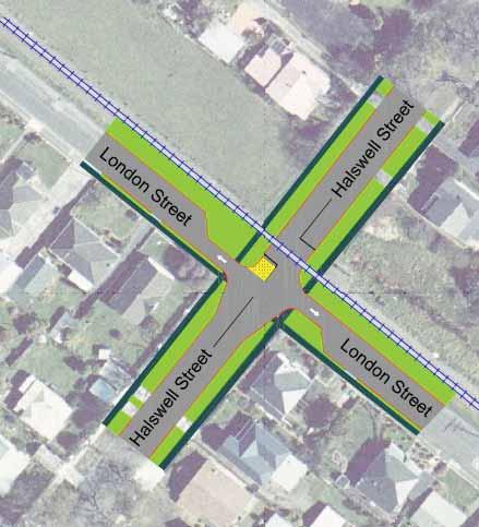
19 to KEY: Roundabout Signals City Centre Bypass Glasgow St Route Possible future signals Springvale Park Carlton Ave London St Glasgow St Purnell Street Victoria Ave Li ton St Halswell St Glasgow St Guyton St Heads Rd Dublin St Bell St Somme Pde WANGANUI Change priority Dublin Br x Victoria Ave St Hill St Jones St Road Closure Entry Treatments Moutoa Gardens riverfrontenhancement 15

20 16 riverfrontenhancement
21 ACTION NO. 16 LINKS TO OBJECTIVES ACTIONS 7 LINKAGES RESPONSIBILITY RIVER FRONT CITY CENTRE RIVER FRONT CITY CENTRE RIVER FRONT CITY CENTRE 7 8 riverfrontenhancement 17

22 IVER FRON Y CENTRE 18 enhancingfreightmovement

23 10 An enhancingfreightmovement 10

24 20 enhancingfreightmovement
25 ACTION NO. 23 LINKS TO OBJECTIVES ACTIONS LINKAGES Links RESPONSIBILITY enhancingfreightmovement 21


26 ACTION NO. 27 LINKS TO OBJECTIVES ACTIONS 11 LINKAGES RESPONSIBILITY enhancingfreightmovement


27 RIVER FRONT CITY CENTRE enhancingfreightmovement 23


28 IVER FRON Y CENTRE realtransportchoices

29 making Wanganui cycle friendly will further support cycle tourism realtransportchoices 25


30 desired walking behaviours should be celebrated and encouraged 26 realtransportchoices
31 realtransportchoices 27
32 WAKEFIELD STREET 16 RIV ENUE KOTARE STREE HYLTON STREET PATER ROAD ADLEYS LINE PICK H ROAD KEA PLACE VICTORY PLACE KAIKOKOPU ROAD WARD STREET SAVAGE CRESCENT MANNINGTON ROAD CAMERON ROAD WEST EDMONDS DRIVE CAMERON ROAD EAST WEMBLEY PLACE KOWHAINUI DRIVE FRANCIS ROAD SEAFIELD ROAD TALBOT STREET TIPAI STREET PAULS ROAD MAWAE STREET PARKDALE DRIVE VIRGINIA ROAD SPIER STREET GUMTREE RISE WESTMERE ROAD WILLIAM ROAD BARRACK STREET KEY BOYDFIELD STREET TAY STREET DUNCAN STREET PEAT PLACE OAKLAND AVENUE KAWAU PLACE CHELSEA CLOSE TASMAN VIEWS SANDCROFT DRIVE TAYLOR ROAD JONES STREET SOMME PARADE SPRINGVALE ROAD PITT STREET LONDON STREET KENT ROAD DOWNES AVENUE TAYFORTH ROAD CATHRO ROAD SORRENTO COURT NIBLETT STREET 2010 / / / / / / / / / 2019 Completed Cycle Lanes Completed Cycle/walkways LIVERPOOL STREET GLASGOW STREET PARKES AVENUE ANTRIM PLACE SUSSEX ROAD NZTA Roads Dashed line = On-road cycle lane Solid lines = Cycle/walkway BELL STREET HARRISON STREET DUBLIN STREET STAFFORD STREET SURREY ROAD HAMPTON PLACE WARWICK PLACE LONGBEACH DRIVE KAPITI TERRACE COOKS STREET BASSETT STREET COLLEGE STREET FOX ROAD LINCOLN ROAD WESTBOURNE TERRACE GUYTON STREET INGESTRE STREET SELWYN CRESCENT FITZHERBERT AVENUE BALMORAL CRESCENT LOADER PLACE MOSSTON ROAD TAINUI STREET KAKAHO DRIVE WAITAI STREET KELSI STREET TOI STREET TOTARA STREET LIFFITON STREET CARLTON AVENUE ACCESSWAY WANGANUI METROPOLITAN MOTORWAY BANKS PLACE KOROMIKO ROAD MAHOE PLACE RIMU STREET BENNETT STREET ARMSTRONG PLACE ROGERS STREET GLENN STREET MANUKA STREET KARAKA STREET RUAPEHU STREET MIRO STREET BAMBER STREET BENEFIELD STREET LENIHAN STREET EASTOWN ROAD MILTON STREET HAKEKE STREET RUSSELL STREET DICKSON CRESCENT BRASSEY ROAD DAY ROAD PATAPU STREET NO 3 LINE KEPA STREET JELLICOE STREET AIKEN ROAD CHARLES CLOSE RAINE STREET KAWAKAWA STREET TUROA ROAD PEAKES ROAD TITTER PLACE BULLOCK DRIVE NATHAN STREET BUXTON ROAD IKITARA ROAD KEITH STREET CLARKSON AVENUE DENBY PLACE BASTIA AVENUE MOUNT VIEW ROAD AVON PLACE WAITOTE STREET WICKSTEED STREET SHAKESPEARE ROAD ANZAC PARADE CAMPBELL STREET DEVON ROAD PORTAL STREET SERVICE LANE MARIA PLACE VICTORIA AVENUE ST HILL STREET MILL ROAD MARKET PLACE TAUPO QUAY RIDGWAY STREET SEAFRONT ROAD ALMA ROAD NO 2 LINE PLUNKET STREET HIPANGO TERRACE DEEM PLACE CHURCHILL CRESCENT CORNFOOT STREET WEBB ROAD TAYLOR STREET JACKSON STREET KARAMU STREET MATAI STREET IWIROA TERRACE EAST WAY YORK STREET CARSON STREET KAWATIRI AVENUE OMORI PLACE MUIR STREET HARPER STREET CROSS STREET TAWA STREET SWISS AVENUE HINAU STREET WHARF STREET BIGNELL STREET SHORT STREET MORGAN STREET WAITAHANUI ROAD NGATARUA ROAD BEDFORD AVENUE HEADS ROAD KEMP STREET JOHN STREET KIRK STREET CAVELL PLACE CRACROFT DRIVE PUTIKI DRIVE HORI KINGI STREET KINGS AVENUE BEACH ROAD BALGOWNIE AVENUE GILBERD STREET SH 3 TERE ROAD WIKITORIA ROAD BATE realtransportchoices
33 ACTION NO. 32 LINKS TO OBJECTIVES ACTIONS LINKAGES RESPONSIBILITY 13 realtransportchoices
34 ACTION NO LINKS TO OBJECTIVES ACTIONS LINKAGES RIVER FRONT CITY CENTRE RIVER FRONT CITY CENTRE RIVER FRONT CITY CENTRE RESPONSIBILITY realtransportchoices


35 ACTION NO. LINKS TO OBJECTIVES ACTIONS 12 LINKAGES RIVER FRONT CITY CENTRE RIVER FRONT CITY CENTRE RIVER FRONT CITY CENTRE RESPONSIBILITY 13 realtransportchoices 31


36 TRANSPORT CHOICES IVER FRON Y CENTRE 32 integratinglanduseandtransport


37 focuses on the need for land use planning and provision and maintenance of the transport network to be integrated to be integratinglanduseandtransport 33
38 ACTION NO LINKS TO OBJECTIVES ACTIONS 14 LINKAGES RIVER FRONT CITY CENTRE RIVER FRONT CITY CENTRE RIVER FRONT CITY CENTRE RIVER FRONT CITY CENTRE RIVER FRONT CITY CENTRE 34 integratinglanduseandtransport
39 ACTION NO. LINKS TO OBJECTIVES ACTIONS LINKAGES RIVER FRONT CITY CENTRE 51 integratinglanduseandtransport 35
40 STRATEGIC FIT OF PACKAGES CONCLUSIONS 36


41 RIVER FRONT CITY CENTRE New intersection layout» Simplifies the intersection making it easier for visitors to understand.» Removing conflicting right turn traffic from SH3 improves the flow of traffic movements on SH3 and between Victoria Avenue and St John s Hill.» Centre median to prevent right turning traffic from London Street. Upgraded for heavy commercial traffic - Mosston Rd/Montgomery Rd» Identifies a key heavy transport route requiring protection from inappropriate development. Upgrades will enhance this function.» Fitzherbert Ave extension.» Mill Road/Manuka Street extension Manuka St Mill Rd Living/calmed Streets» Implements measures that discourage the use of residential areas as through routes or shortcuts.» Makes these areas pleasant to live in, easy to get around and where people know their neighbours.» Focusing on people, not cars, to improve the area s pleasantness.» Green areas as a priority, then apply to selected residential streets. New intersection layout - Heads Road Halswell/London St Intersection» Intersection changes prevent rat running on London Street.» Encourages use of Glasgow Street for cross-town traffic. Fitzherbert Ave Heads Rd London St Smithfield Road Closure» Make Smithfield road no exit, reducing turning movements at Smithfield/SH3 Intersection» Reduces congestion around this rail crossing intersection and provides for the imminent increase in rail traffic. x Carlton Ave Glasgow St Purnell St Dublin St Victoria Ave Somme Pde Guyton St Taupo Quay Anzac Pde» Changes at Somme Parade intersections with Glasgow Street and Dublin Street prioritise cross town routes.» Changes at the Somme Parade intersection and road improvements prioritise traffic flows to and from Glasgow Street.» New Dublin Street intersection layout and road improvements prioritise traffic movements between Dublin Street and the bridge.» Motorised access to the riverfront is via Pitt Street» Reduced turning movements improves road safety for all road users at this intersection. Intersection improvements to ease congestion» Reduces congestion at peak times around St Hill St/ Taupo Quay and the City Bridge. Historic Tramway» Takes advantage of the reduced motorised traffic flows along Somme Parade.» Clockwise route to follow Victoria Avenue, Guyton Street, Somme Parade and Taupo Quay. Central Area pedestrian priority zone» Prioritises pedestrians instead of motor vehicles. Somme Parade Intersections Traffic reduction needed for riverfront development» Heavy vehicles will use Glasgow or Dublin Street to cross town or link to SH3.» Routes will be enhanced to facilitate these movements.» Discourages through traffic and enhances pedestrian amenity.» Reduces on street parking but increases quality and provision of adjacent off street car parking areas. wanganuicity 37
42 WAYFINDING IS EASY ASSIST ECONOMIC DEVELOPMENT ASSIST SAFETY AND PERSONAL SECURITY LTMA IMPROVE ACCESS AND MOBILITY PROTECT AND PROMOTE PUBLIC HEALTH ENSURE ENVIRONMENTAL SUSTAINABILITY VIBRANT CENTRAL AREA RIVERFRONT ENHANCEMENT FREIGHT ENHANCEMENT TRANSPORT CHOICES 38
43
44
REPORT ON SUBMISSION TO LET S GET WELLINGTON MOVING
 CITY DIRECTION COMMITTEE 31 JANUARY 2018 REPORT ON SUBMISSION TO LET S GET WELLINGTON MOVING PURPOSE This paper outlines the submission made by the Chief Executive under delegated authority to Let s Get
Figure 3: Global Sydney. Draft Metropolitan Strategy for Sydney. North Sydney CBD. Second Harbour Crossing. Walsh Bay Arts Precinct.
 Newtown Glebe Macdonaldtown Pyrmont Ultimo Sydney International Convention, Exhibition & Entertainment Precinct Sydney Education & Health Erskineville Figure 3: Global Sydney Waterloo Second Harbour Crossing
ROTORUA INTEGRATED NETWORK STRATEGY
 ROTORUA INTEGRATED NETWORK STRATEGY 2012-2042 May 2013 This photo provided by RDC Cover photos provided by RDC and BOPRC Contents Context Issues for the Strategy to Address Outcomes and Interventions Implementation
RE: Victoria Road upgrade (RTA December 2007). Thank you for the briefing from your department and the invitation to comment on the above.
. Thank you for the briefing from your department and the invitation to comment on the above.") Iain Macleod Project Manager Victoria Road upgrade Roads and Traffic Authority PO Box 743 Drummoyne NSW 1470 e : Victoria_Road_Info@rta.nsw.gov.au 21 February 2008 RE: Victoria Road upgrade (RTA December
Iain Macleod Project Manager Victoria Road upgrade Roads and Traffic Authority PO Box 743 Drummoyne NSW 1470 e : Victoria_Road_Info@rta.nsw.gov.au 21 February 2008 RE: Victoria Road upgrade (RTA December
CHRISTCHURCH MOTORWAYS. Project Summary Statement February 2010
 CHRISTCHURCH MOTORWAYS Project Summary Statement February 2010 Table of Contents 1. Purpose of Document 2. Strategic Context 3. Benefits 4. Project Scope and Economics 5. Implementation Plan 1 ROADS OF
Have your say on Let s Get Wellington Moving PUBLIC FEEDBACK IS OPEN UNTIL FRIDAY 15 DECEMBER 2017
 Have your say on Let s Get Wellington Moving PUBLIC FEEDBACK IS OPEN UNTIL FRIDAY 15 DECEMBER 2017 Getting Wellington moving Let s Get Wellington Moving is a joint initiative between Wellington City Council,
Draft City Centre Transport Proposals
 Draft City Centre Transport Proposals Introduction This draft position paper provides an overview of the current City Centre transport issues, including concepts of the possible future City Centre transport
WELLINGTON $422 MILLION $614 MILLION $83 MILLION 22% SPEND $1.9 BILLION
 WELLINGTON WELLINGTON $1.9 BILLION FORECAST TOTAL WELLINGTON INVESTMENT The Wellington region s transport challenges are dominated by the region s concentration of population in the metropolitan cities,
Wellington $312 $49 $456 OVERVIEW WELLINGTON REGIONAL SUMMARY
 National Land Transport Programme 2015 18 Wellington WELLINGTON REGIONAL SUMMARY OVERVIEW The Wellington region is made up of a number of cities, urban areas and supporting rural hinterland. The city is
MOUNT MAUNGANUI/PAPAMOA SUMMER EVENT ROAD CLOSURES
 MOUNT MAUNGANUI/PAPAMOA SUMMER EVENT ROAD CLOSURES ADAMS SUNDAY, 8 OCTOBER 2017 MOUNT BUSKING FESTIVAL COMMONS VICTORIA RD VICTORIA RD PACIFIC NUE PRINCE PACIFIC COMME RCE LN SALISBURY SALISBURY CORONATION
Have your say... on the Ian McKinnon Drive Cycleway Project
 Have your say... on the Ian McKinnon Drive Cycleway Project The missing cycleway link connecting the Northwestern Cycleway and Dominion Road cycle lanes to the Grafton Gully Cycleway, Te Ara I Whiti Lightpath
Report to: Greater Cambridge Partnership Joint Assembly 18 January A10 Foxton level crossing bypass and travel hub
 Report to: Greater Cambridge Partnership Joint Assembly 18 January 2018 Lead officer: Chris Tunstall GCP Director of Transport A10 Foxton level crossing bypass and travel hub 1. Purpose 1.1 The list of
places Mooloolaba s heart five
 five places the mooloolaba heart 1 Flexible community event use of school oval 2 Enhanced streetscape District cycle route Future cross-block pedestrian link 5 Existing school buildings New signalised
Sydney CBD - Partnering with the coach industry for solutions
 Sydney CBD - Partnering with the coach industry for solutions Steve Issa Executive Director Operations and Planning Transport for NSW 16 June 2017 Tomorrow s Sydney Responding to growth: Sydney s population
FUTURE TRANSPORT STRATEGY AND GREATER SYDNEY SERVICES AND INFRASTRUCTURE PLAN. Western Parkland City
 FUTURE TRANSPORT STRATEGY AND GREATER SYDNEY SERVICES AND INFRASTRUCTURE PLAN Western Parkland City 2 Transport for NSW Future Transport Strategy and Greater Sydney Services and Infrastructure Plan Western
EAST-WEST STITCH. Connecting the Western Edge of the City to the Centre
 98 AC_BEU_CCMP_2_TM1_4 _FD.indd 98 20/07/12 12:06 PM 02 EAST-WEST STITCH Connecting the Western Edge of the City to the Centre 01 02 Northern Motorway Daldy Street Fanshawe Street Nelson Street Hobson
Chapter 25 Route Window SE6 Plumstead portal. Transport for London
 Chapter 25 Route Window SE6 Plumstead portal PLUMSTEAD PORTAL 25 Route Window SE6 Plumstead portal Introduction 25.1 The Crossrail route will follow the present alignment of the North Kent Line from a
FEDERAL BUDGET PRIORITIES FOR THE SOUTH WEST METROPOLITAN REGION 2018 TO 2022
 A Co-operative venture of the municipalities of: Cockburn, East Fremantle, Fremantle, Kwinana, Melville & Rockingham Tuesday, 5 December 2017 Enquiries: Mick McCarthy 9364 0631 Our Ref: Federal Budget
Congestion. Addressing urban congestion in SEQ. How do you define congestion? South East Queensland is growing. Sustained growth in motorised travel
 How do you define congestion? Addressing urban congestion in SEQ Engineer: traffic volume exceeds road capacity Russell Murray Director Urban Congestion Task Force Department of Transport and Main Roads
Northern Beaches Transport Action Plan
 Northern Beaches Transport Action Plan The NSW Government is taking action now to deliver transport improvements for the Northern Beaches, as well as planning for the future growth of the area. $633 million
Greater Shepparton City Council Planning Scheme Amendment C192 and C193 VicRoads Submission to Traffic Conclave
 Greater Shepparton City Council Planning Scheme Amendment C192 and C193 VicRoads Submission to Traffic Conclave Prepared by: Raelene Stratton Team Leader Integrated Transport and Land Use, North Eastern
Blackburn Road Blackburn Level Crossing Removal. Frequently Asked Questions August 2014 GENERAL
 Frequently Asked Questions August 2014 Blackburn Road Blackburn Level Crossing Removal GENERAL What is the project? The Victorian Government has committed to eliminating a number of the busiest level crossings
TRAFFIC MANAGEMENT INFORMATION ED SHEERAN PAIRC UI CHAOIMH
 TRAFFIC MANAGEMENT INFORMATION ED SHEERAN PAIRC UI CHAOIMH 1 RATIONALE The Garda Traffic Management Plan is designed to attempt to address the current infrastructural deficits with the location of the
$244 $45 OVERVIEW National Land Transport Programme Bay of Plenty BAY OF PLENTY REGIONAL SUMMARY
 2015 18 National Land Transport Programme Bay of Plenty BAY OF PLENTY REGIONAL SUMMARY OVERVIEW Transport investment in the Bay of Plenty is targeted to support significant residential growth, new industrial
AGENDA TEMPORARY ROAD CLOSURE SUBCOMMITTEE MEETING. Wednesday, 27 September 2017 Commencing at 8.30 am
 AGENDA TEMPORARY ROAD CLOSURE SUBCOMMITTEE MEETING Wednesday, 27 September 2017 Commencing at 8.30 am Nikau Room, Tauranga City Council 91 Willow Street, Tauranga NOTICE OF MEETING I hereby give notice
Chapter 8 Route Window NE7 Chadwell Heath station. Transport for London
 Chapter 8 Route Window NE7 Chadwell Heath station Transport CHADWELL HEATH STATION 8 Route Window NE7 Chadwell Heath station Baseline conditions 8.6 This route window lies within the London Boroughs of
The Point Roundabout Improvement Scheme
 The Point Roundabout Improvement Scheme Background and Existing Situation The junction of North Wall Quay, East Wall Road and the East Link Bridge, also known as the Point roundabout, is located in the
Part four. In this part you will find: The next steps to deliver the master plan
 Part four NEXT STEPS In this part you will find: The next steps to deliver the master plan 6. How COULD the Master Plan be delivered? There are a number of steps required to take the proposals in the master
AUCKLAND $1.2 BILLION $1.9 BILLION $149 MILLION 15% SPEND $5.7 BILLION
 AUCKLAND AUCKLAND $5.7 BILLION FORECAST TOTAL AUCKLAND INVESTMENT The next 10 years are expected to underline Auckland s performance as the fastest growing major city in Australasia. The city is expected
PLANNING THE SUNBURY GROWTH CORRIDOR
 SUNBURY GROWTH CORRIDOR NOVEMBER 2016 PLANNING THE SUNBURY GROWTH CORRIDOR Sunbury Planning Background The Victorian Planning Authority, in consultation with Hume City Council, is undertaking a number
SUMMARY. Make the town centre better for pedestrians with shared spaces and improved connections
 SUMMARY FOUR INITIATIVES will lead the strategy implementation Make the town centre better for pedestrians with shared spaces and improved connections Connecting Melbourne and Henry Street to improve access
Council Briefing Minutes
 1 Council Briefing Minutes Date: Time: Location: In Attendance Not in Attendance Wednesday, 24 October, 2018 2:30 p.m. Council Chamber Forum North, Rust Avenue Whangarei Cr Greg Innes (Chairperson) Cr
Ian Saxon Assistant Executive Director, Environmental Services
 Report To: SPEAKERS PANEL (PLANNING) Date: 14 December 2016 Reporting Officer: Ian Saxon Assistant Executive Director, Environmental Services Subject: OBJECTIONS TO PROPOSED REMOVAL OF LEECH STREET / BACK
Route 141 and I-44 Design-Build Project Community Involvement Group. March 21, 2016
 Route 141 and I-44 Design-Build Project Community Involvement Group March 21, 2016 Purpose of CIG 1. Share information with major stakeholders 2. Keep stakeholders informed of the process 3. Reduce uncertainty
3. COLTA / HUGA CONNECTIONS - PRELIMINARY
 9 3. COLTA / HUGA CONNECTIONS - PRELIMINARY 3.1 COLTA The Chain of Lakes Trail Association (COLTA) trail, formerly identified as the Chester Spur Line, was completed and opened for use in June 2011. The
London Borough of Barnet Traffic & Development Design Team
 London Borough of Barnet Traffic & Development Design Team AERODROME ROAD PEDESTRIAN FACILITY AND BUS STOP INTRODUCTION FEASIBILITY REPORT Job Number: 60668 Doc Ref: S106/12-13/60668 Author: Manoj Kalair
Kilometres. Blacktown. Penrith. Parramatta. Liverpool Bankstown. Campbelltown
 0 5 10 15 20 Kilometres Penrith Blacktown Parramatta Liverpool Bankstown Campbelltown accessibility outcomes Legend Outcomes targeted in Western Sydney are: public transport that is accessible throughout
Next Generation Cycleway Design. Improving connectivity and cycling behaviours through design
 Next Generation Cycleway Design Improving connectivity and cycling behaviours through design Safe segregation between Place Users to offer improved safety and a defined space for each user group Elevated
Major Scheme Business Case Summary Report for Programme Entry
 Paper A Heart of South West Local Transport Board Major Scheme Business Case Summary Report for Programme Entry M5 Junction 25, Taunton July 2016 1 SCHEME SUMMARY Scheme Name M5 Junction 25, Taunton Date
Transit s forecasts of expenditure in Waikato for the next 10 years are set out in Table WK1.
 WAIKATO STATE HIGHWAY PLAN EXECUTIVE SUMMARY Transit s forecasts of expenditure in Waikato for the next 10 years are set out in Table WK1. These forecasts of expenditure are based on a 10-year plan of
Committee. Presentation Outline
 CW-33-15 11/9/2015 Community and Corporate Services Committee November 10, 2015 1 Presentation Outline Background Vision and Objectives Study Process and Timeline Public and Stakeholder Engagement Organization
Chapter 6 Route Window NE5 Seven Kings station. Transport for London
 Chapter 6 Route Window NE5 Seven Kings station Transport SEVEN KINGS STATION 6 Route Window NE5 Seven Kings Station Transport Introduction 6.1 All construction activities in this route window are associated
BUSINESS ZONE - OPTION 400 (Western footpath) Have your say. Love the Bay Delivering on the Cycleway
 Have your say. Love the Bay Delivering on the Cycleway") BUSINESS ZONE - OPTION 400 (Western footpath) Have your say Love the Bay Delivering on the Cycleway Consultation open from 31 July to 13 August 2017 1 Introduction After the Love the Bay community-based
BUSINESS ZONE - OPTION 400 (Western footpath) Have your say Love the Bay Delivering on the Cycleway Consultation open from 31 July to 13 August 2017 1 Introduction After the Love the Bay community-based
N4 Carrick-on-Shannon to Dromod Road Project. 2.1 Introduction
 Chapter 2 Need for the Scheme 2.1 Introduction The National Primary Route N4, Dublin to Sligo is a strategic corridor from Dublin to the northwest and border counties (See RCSR 101 in Volume 2). The National
Port Macquarie-Hastings Pedestrian Access and Mobility Plan. Working Paper COMMUNITY ENGAGEMENT
 Port Macquarie-Hastings Pedestrian Access and Mobility Plan Working Paper COMMUNITY ENGAGEMENT December 2014 Table of Contents Table of Contents... 2 1 Introduction... 3 2 Submissions... 3 2.1 Stakeholder
LYNDHURST NEW URBAN DEVELOPMENT AREA STRUCTURE PLAN. Lyndhurst New Urban Development Area Structure Plan OUTCOMES AND PERFORMANCE STANDARDS
 APPENDIX 15.1-3 LYNDHURST NEW URBAN DEVELOPMENT AREA STRUCTURE PLAN Purpose of the Structure Plan Lyndhurst New Urban Development Area Structure Plan OUTCOMES AND PERFORMANCE STANDARDS LSP-P1 The District
Community Advisory Panel Meeting #
 Community Advisory Panel Meeting # 6 02.13.19.. Agenda Welcome and Introductions Community Conversations City Council Meeting Debrief Review Citywide Tunnel Video (North Portal Only) Churchill Pedestrian
South Australia Transport Infrastructure Summit Adelaide May 2009
 TOWARDS 2020: RAA s vision for metropolitan adelaide Sharon Hanlon General Manager Public Affairs Royal Automobile Association (RAA) of South Australia Inc INTRODUCTION The Royal Automobile Association
50MAX Book of Maps. North Island Waikato Region. March of 23
 March 2018 1 of 23 6 BSN: 305 6 BSN: 107 6 BSN: 458 6 6 BSN: 661 BSN: 1211 0 50 6 BSN: 511 March 2018 2 of 23 50MAX Road Controlling Authorities - Local roads can be used EXCEPT for the restricted bridges/roads
Amendments C207 & C208
 Amendments C207 & C208 Hume Planning Scheme Julia Bell August 2017 Instructed by KING&WOOD MALLESONS On behalf of Hume City Council Amendments C207 & C208 Hume Planning Scheme Contents 1.0 Introduction...
PROJECTS. Otonabee South Monaghan. Active Transportation Master Plan Proposed Ultimate Network
 Otonabee South Monaghan Ultimate Network Otonabee-South Monaghan, located on the north shore of Rice Lake, is home to Lang Pioneer Village, Harold Town Conservation Area and numerous resorts that are major
CUMULATIVE IMPACTS CHAPTER TWENTY-SIX
 CUMULATIVE IMPACTS CHAPTER TWENTY-SIX 26 Cumulative impacts This chapter provides an assessment of the potential cumulative impacts as a result of the project, and identifies mitigation measures to minimise
Town Centre Improvements Plan
 Phase 1 Experience Barnsley External Works Phase 1 Town Hall Open Space Lancaster Gate side of Town Hall Shambles Street Footway and Kerbing North Side (St Mary s Place to Church street) St Mary s Place
The Coalition s Policy to Build the Swan Valley Bypass and Perth Gateway
 1 Our Plan Real Solutions for all Australians The direction, values and policy priorities of the next Coalition Government. The Coalition s Policy to Build the Swan Valley Bypass and Perth Gateway August
We further recognise that some pain and changes are required from the entire City in order to construct and deliver the project.
 70 Merivale Street PO Box 2001 South Bank QLD 4101 Ph: 07 3846 5191 Email: janinew@businesssouthbank.com.au www.businesssouthbank.com.au ABN 28 285 012 048 21 May 2018 The Right Honourable Lord Mayor Councillor
State Road Upgrades Northern Region
 State Road Upgrades Northern Region A MAJORITY LIBERAL GOVERNMENT WILL: Commence a five year program to deliver more than $142 million in road improvements for the Northern region for safety and travel
Halswell-Hornby-Riccarton Community Board Submissions Committee AGENDA
 Halswell-Hornby-Riccarton Community Board Submissions AGENDA Notice of Meeting: An ordinary meeting of the will be held on: Date: Wednesday Time: 4pm Venue: Board Room, Fendalton Service Centre, Corner
Upper Clutha Transport Report
 Upper Clutha Transport Report Shaping our Future Vision for the Upper Clutha incorporating Land, Air and Water Transport: The Queenstown Lakes District has a functional, innovative, integrated, multi-modal
Co-ordinated and Orderly Growth A Suite of Infrastructure and Public Assets for the Future... 1
 Co-ordinated and Orderly Growth... 1 A Suite of Infrastructure and Public Assets for the Future... 1 Funding Sources, Revenues and Prioritising Expenditure... 2 Stage 1 Short Term Growth Sunbury to 50,000...
Land Management Summary
 photo credit: ANGAIR Anglesea Heath Land Management Summary The Anglesea Heath (6,501 ha) was incorporated into the Great Otway National Park in January 2018. This provides an opportunity to consider the
City of Port Adelaide Enfield Report for Port Adelaide Centre Car Parking and Movement Study. Final Report
 City of Port Adelaide Enfield Report for Port Adelaide Centre Car Parking and Movement Study October 2011 This Report: 1. has been prepared by GHD Pty Ltd for the City of Port Adelaide Enfield; 2. may
Reimagining Central Station Precinct
 Reimagining Central Station Precinct Submission by BusNSW 1. Introduction BusNSW members provide bus and coach transport services throughout NSW under various contractual and regulatory environments. This
RUSTINGTON PARISH COUNCIL PLANNING COMMITTEE
 MINUTES: of the Meeting held on 26 June 2017 RUSTINGTON PARISH COUNCIL PLANNING COMMITTEE PRESENT: Councillors R Grevett (Chairman), J Bennett, Mrs A Cooper, T Field, A Jones, J Street and P Warren 58/17
Welcome. Great Yarmouth Third River Crossing. Norfolk County Council
 Welcome Great Yarmouth Third River Crossing We are proposing to build a new bridge between Harfreys Roundabout and South Denes Road, and we would like your views. This consultation is stage two of a three-stage
Chapter 21 Route window W6 West Ealing station. Transport for London
 Chapter 21 Route window W6 West Ealing station WEST EALING STATION 21 Route window W6 West Ealing station Baseline conditions 21.6 West Ealing station is located in the London Borough of Ealing and is
New West End Company. Richard Dickinson. New West End Company Chief Executive. Capital Management
 New West End Company Richard Dickinson New West End Company Chief Executive Capital Management New West End Company New West End Company is a company dedicated to driving forward London s West End as the
[REGIONAL LAND TRANSPORT PROGRAM AND REGIONAL FUEL TAX SUBMISSION ]
![[REGIONAL LAND TRANSPORT PROGRAM AND REGIONAL FUEL TAX SUBMISSION ]](/thumbs/89/99007492.jpg "[REGIONAL LAND TRANSPORT PROGRAM AND REGIONAL FUEL TAX SUBMISSION ]") 2018 Ben Ross Talking Southern Auckland Picture 1: Manukau Bus Station with MIT and rail station in the background [REGIONAL LAND TRANSPORT PROGRAM AND REGIONAL FUEL TAX SUBMISSION ] Submission to the
2018 Ben Ross Talking Southern Auckland Picture 1: Manukau Bus Station with MIT and rail station in the background [REGIONAL LAND TRANSPORT PROGRAM AND REGIONAL FUEL TAX SUBMISSION ] Submission to the
US 19 Sunset Point Rd to Countryside Blvd.
 Frontage Lanes Alternative Six-Lane Roadway Two-Lane, One-Way Frontage Lanes Close All Median Openings w/ Concrete Median Barrier Construct Within Existing Right-of-Way Status Update Construction started
$745 $10 $41 OVERVIEW
 2015 1 National Land Transport Programme Southern SOUTHERN REGIONAL SUMMARY The NZ Transport Agency s Southern region comprises the local government regions of Canterbury, Otago, Southland and the West
Llandudno Junction. Regeneration Proposals for the Future. December 2009
 Llandudno Junction Regeneration Proposals for the Future December 2009 Llandudno Junction - Vision Statement 1 Purpose 1.1 The purpose of this document is to describe key priorities to support the regeneration
7.0 GROUND TRANSPORT DEVELOPMENT PLAN OVERVIEW. Sydney Airport Master Plan
 7.0 GROUND TRANSPORT DEVELOPMENT PLAN OVERVIEW Sydney Airport Master Plan 2033 87 7.0 GROUND TRANSPORT DEVELOPMENT PLAN OVERVIEW Key points On Airport Drive, non-airport through-traffic accounts for up
WALKWAYS & CYCLING GUIDE
 WALKWAYS & CYCLING GUIDE visitwhanganui.nz Directory Whanganui is filled with numerous places to walk and cycle within the city and surrounds. We hope to provide you with options within this brochure so
Policy Transport. Policy highlights. Our plan
 Policy 2017 Our plan Policy highlights National is committed to building the world-class infrastructure to ensure New Zealand continues to grow. Record investment in transport Delivering the Roads of National
Pedestrian Safety Review Spadina Avenue
 STAFF REPORT ACTION REQUIRED Pedestrian Safety Review Spadina Avenue Date: October 13, 2015 To: Toronto and East York Community Council From: Director, Transportation Services, Toronto and East York District
Score. Category. Access Aesthetics Community Resources
 NO BUILD ALTERNATIVE The No Build Alternative is the do nothing option that is used for comparison to the build alternatives. The screening assumes no new facilities are constructed as part of the I-93
Transport Assessment Appendix M: Avonmouth Impacts
 Portishead Branch Line (MetroWest Phase 1) Environmental Impact Assessment Transport Assessment Appendix M: Avonmouth Impacts Prepared for West of England Councils December 2016 1 The Square Temple Quay
21.07 ECONOMIC DEVELOPMENT AND EMPLOYMENT 19/03/2015 C323 Proposed C Key issues and influences. Economic Role and Function
 21.07 ECONOMIC DEVELOPMENT AND EMPLOYMENT 19/03/2015 C323 Proposed C347 21.07-1 Key issues and influences 14/10/2010 C168 Economic Role and Function Geelong is the largest regional city in Victoria and
WORKING DRAFT (DECEMBER 2016) - FOR COMMUNITY REVIEW BY
 - FOR COMMUNITY REVIEW BY") PURPOSE The purpose of this Working Draft Spatial Framework summary is to facilitate additional public and stakeholder feedback following the public meetings and reference group workshops held in November
PURPOSE The purpose of this Working Draft Spatial Framework summary is to facilitate additional public and stakeholder feedback following the public meetings and reference group workshops held in November
The Belfast Manifesto
 TheBelfast Manifesto NIIRTA The Northern Ireland Independent Retail Trade Association (NIIRTA) strongly supports The Belfast Manifesto. This should be required reading for election candidates to both Belfast
The Cobham Room, Novotel Hamilton Tainui, 7 Alma Street, Hamilton
 Board Meeting Minutes Date & time Location Board Membership Apologies NZTA staff in attendance 12 August 2016, 8.00am 12.30pm Board Strategy Session 1.00pm 2.30pm The Cobham Room, Novotel Hamilton Tainui,
Boston Redevelopment Authority 2/26/ Chestnut Hill Avenue Boston/Brookline, MA
 Boston Redevelopment Authority 2/26/2014 Cassidy Playground Waterworks Design revisions made since the DPIR submission March 2013 Massing - Reduced project 16,030 SF, for a total project area of 218,520
State Road Upgrades Southern Region
 State Road Upgrades Southern Region A MAJORITY LIBERAL GOVERNMENT WILL: Undertake an historic reset of roads and traffic management in Southern Tasmania taking roads to the next level. Underpin the extraordinary
Development Committee on 3 December 2013;
 7 2. Endorses the bus route for the new free City Connector bus service as set out in Attachment B to Item 9 on the Agenda for the meeting of the City Planning & Development Committee on 3 December 2013;
GO MEDIA UPPER NORTH IS. CLASSIC SITECARDS (DEC-JAN)
") GO MEDIA UPPER NORTH IS. CLASSIC SITECARDS (DEC-JAN) NORTHLAND A - WHAN1-62, WHAN1-61 Whāngārei This site is located in the heart of Whāngārei targeting a large pedestrian and vehicle audience, close to
GO MEDIA UPPER NORTH IS. CLASSIC SITECARDS (DEC-JAN) NORTHLAND A - WHAN1-62, WHAN1-61 Whāngārei This site is located in the heart of Whāngārei targeting a large pedestrian and vehicle audience, close to
Construction Staging Adelaide Street West
 REPORT FOR ACTION Construction Staging Adelaide Street West Date: October 6, 2016 To: Toronto and East York Community Council From: Acting Director, Transportation Services, Toronto and East York District
Roads and Maritime Services Presentation to Local Government NSW Annual Conference October 2014
 Roads and Maritime Services Presentation to Local Government NSW Annual Conference October 2014-1 - About Roads and Maritime Services Deliver customerfocused services and infrastructure to the value of
50MAX Book of Maps. North Island Bay of Plenty Region. March of 18
 50MAX Book of Maps North Island Bay of Plenty Region March 2019 1 of 18 50MAX Book of Maps Version: March 2019 North Island North Island BSN: 305 Legend State Highway 50MAX Restrictions BSN: 458 BSN: 225
EDEN PARK REDEVELOPMENT COMPLETED STADIUM DESIGN
 1 INTRODUCTION New Zealand was awarded the Rugby World Cup 2011 hosting rights in November 2005. A condition of the winning bid was the provision of a 60,000 seat stadium for the finals. New Zealand s
London and South East Route Utilisation Strategy (RUS) Rail User Group Meeting - Saturday 11 July 2009
 Rail User Group Meeting - Saturday 11 July 2009") London and South East Route Utilisation Strategy (RUS) Rail User Group Meeting - Saturday 11 July 2009 Appendix 1 Flip chart notes from Breakout Groups Groups were asked to consider what gaps and issues
London and South East Route Utilisation Strategy (RUS) Rail User Group Meeting - Saturday 11 July 2009 Appendix 1 Flip chart notes from Breakout Groups Groups were asked to consider what gaps and issues
A link to heritage by connecting the community to its history.
 In March 2015 the Board of Sentiers Chelsea Trails asked Chelsea Council to explore the feasibility of converting the winter rail corridor trail into a 4 season, non-motorized, multi-purpose trail. To
South East Traffic Solution
 South East Traffic Solution A MAJORITY LIBERAL GOVERNMENT WILL: Complete the Hobart Airport Interchange project Fix the Tasman Highway near Tasmania Golf Club Replace the Midway Point Roundabout with additional
4 Transport projects underway in Western Sydney
 4 Transport projects underway in Western Sydney About this chapter This chapter provides an overview of the Australian and NSW government s significant investments in road, bus and rail infrastructure
Launceston City Council. Kings Meadows Traffic Management Report for Public Consultation
 Launceston City Council Kings Meadows Traffic Management Report for Public Consultation November 2013 This report: has been prepared by GHD for Launceston City Council and may only be used and relied on
Bridging Brisbane Survey 2017 Supplementary Report
 1: Moggill Road Bridge (at Moggill ferry crossing) This river crossing connects Moggill Ferry Road at Riverview with the end of Moggill Road at Moggill where the ferry currently operates. It links the
5 Rail demand in Western Sydney
 5 Rail demand in Western Sydney About this chapter To better understand where new or enhanced rail services are needed, this chapter presents an overview of the existing and future demand on the rail network
6 Road infrastructure
 6 Road infrastructure 51 ƨƨsummary New Zealand does not score highly for its road infrastructure when compared to other developed nations. This may partly be due to geography and population size, which
Ground Transportation Strategy. Victoria Airport Authority
 Ground Transportation Strategy Victoria Airport Authority VAA Ground Transportation Strategy We live on an Island in the Pacific, but we are not isolated. A 15 minute flight from the Victoria International
AUCKLAND WATERFRONT VISION 2040
 AUCKLAND WATERFRONT VISION 2040 HARBOUR BRIDGE WESTHAVEN MARINA WYNYARD POINT WESTERN RECLAMATION VIADUCT HARBOUR FANSHAWE STREET VICTORIA PARK PRINCES WHARF QUEENS WHARF PORT CAPTAIN COOK WHARF QUAY STREET
waterview connection Completing the Western Ring Route the Waterview Connection
 waterview connection MAY 2009 Completing the Western Ring Route the Waterview Connection The NZ Transport Agency (NZTA) has a new proposal to complete the Western Ring Route around Auckland by connecting
IL 390 Station. Wood Dale Open House Summary 5/18/17
 Wood Dale Open House Summary 5/18/17 The first public open house for the Wood Dale Comprehensive Plan took place on May 18 th, 2017. The program was conducted as a fun community event and there were 216