City of Port Adelaide Enfield Report for Port Adelaide Centre Car Parking and Movement Study. Final Report
|
|
|
- Lorin Lynch
- 6 years ago
- Views:
Transcription


1 City of Port Adelaide Enfield Report for Port Adelaide Centre Car Parking and Movement Study October 2011
2 This Report: 1. has been prepared by GHD Pty Ltd for the City of Port Adelaide Enfield; 2. may only be used and relied on by the City of Port Adelaide Enfield; 3. must not be copied to, used by, or relied on by any person other than the City of Port Adelaide Enfield without the prior written consent of GHD; 4. may only be used for the purpose of planning for the Port Adelaide Centre (and must not be used for any other purpose). GHD and its servants, employees and officers otherwise expressly disclaim responsibility to any person other than the City of Port Adelaide Enfield arising from or in connection with this Report. To the maximum extent permitted by law, all implied warranties and conditions in relation to the services provided by GHD and the Report are excluded unless they are expressly stated to apply in this Report. The services undertaken by GHD in connection with preparing this Report: were limited to those specifically detailed in Sections 1 to 6 and 8 of this Report; did not include Section 7 provided by Leedwell Strategic. The opinions, conclusions and any recommendations in this Report are based on assumptions made by GHD when undertaking services and preparing the Report ( Assumptions ), including (but not limited to): data for the parking demand analysis was provided by Land Management Corporation as part of the McLaren Wharf Masterplan information from the Cruickshank s Corner Parking Demand Study completed for the Land Management Corporation in October 2010 was used in this report GHD expressly disclaims responsibility for any error in, or omission from, this Report arising from or in connection with any of the Assumptions being incorrect. Subject to the paragraphs in this section of the Report, the opinions, conclusions and any recommendations in this Report are based on conditions encountered and information reviewed at the time of preparation and may be relied on until six months, after which time, GHD expressly disclaims responsibility for any error in, or omission from, this Report arising from or in connection with those opinions, conclusions and any recommendations.
3 Contents Executive Summary 1 1. Introduction Background Car Parking Precincts within the Port Adelaide Centre Study Objectives Report Structure Planning Context Strategic Planning Documents McLaren Wharf and Cruickshank s Corner Precincts Master Plan History of Car Parking Studies in the Port Adelaide Centre Other Relevant Documents Port Adelaide Enfield (City) Development Plan Summary of Stakeholder Consultation Government Agencies Port Adelaide Businesses Museums and Tourist Operators Summary of the Key Findings from the Stakeholder Discussions Public Car Parking Capacity Assessment Existing Parking Controls and Land Ownership Car Parking Surveys Parking Occupancy by Comparing Aerial Imagery Analysis of Car Parking Capacity in Port Adelaide Traffic, Bus and Pedestrian Movements Traffic Movements Public Transport Pedestrian Movements Future Car Parking Demand Development of a Strategic Parking Policy Future Directions for Car Parking in the Port Adelaide Centre Future Public Parking Demand by Precinct Funding Mechanisms for Additional Car Parking 110
4 7.1 Background to the Port Adelaide Centre Car Parking Fund Review of the Port Adelaide Centre Car Parking Fund Port Adelaide Centre Car Parking Fund Council Grant Scheme Funding Options for Increased Public Car Parking Port Adelaide Car Parking Fund Recommendations Conclusions and Recommendations Conclusions Suggested Short Term Measures Suggested Medium Term Initiatives Suggested Long Term Strategies 138 Table Index Table 1 Existing Parking Capacity by Precinct 12 Table 2 Table 3 Car Parking Generation Rates Proposed in the QED Parking and Movement Report 27 Space and Vacancy Rates for Retail Premises in the Port Adelaide Centre 34 Table 4 Trading Hours at the Port Mall Shopping Centre 47 Table 5 Trading Hours at the Port Canal Shopping Centre 50 Table 6 Table 7 Table 8 Weekday Car Parking Demand Forecasts in the Port Adelaide Centre 103 Car Parking Rates Used for the Future Car Parking Demand Analysis 104 Additional Car Parking Demand from the McLaren Wharf Yield Table 105 Table 9 Public Car Park Funding Options 115 Table 10 Applicability of Public Car Park Funding Options 123 Table 11 Table 12 Car Parking Rates at Hillarys Boat Harbour, Western Australia 143 Car Parking Rates for the Albany Waterfront, Western Australia 144 Figure Index Figure 1 Figure 2 Overview of the Public Car Parking Capacity Assessment for the Port Adelaide Centre 2 Comparison of Parking Capacity to Future Car Parking Demand in the Port Adelaide Centre for the Long Term Scenario 4
5 Figure 3 Figure 4 Figure 5 Figure 6 Figure 7 Suggested Parking Controls for the Port Adelaide Centre 5 Suggested Street Infrastructure Plan for the Port Adelaide Centre 6 Pedestrian Movement Network with Suggested Bus Stop Relocations 7 Port Adelaide Centre Car Parking and Movement Study Area 9 Car Parking Precincts Within the Port Adelaide Centre 11 Figure 8 Port Adelaide Policy Areas 15 Figure 9 Site for the Newport Quays Precinct 5 Development 21 Figure 10 Figure 11 McLaren Wharf and Cruickshank s Corner Precinct Study Area 23 Off-Street Car Parking Strategy in the 1997 Car Parking and Traffic Management Plan 24 Figure 12 Parking Strategy Proposed in the 2003 QED Study 28 Figure 13 Figure 14 Options Proposed in the Port Adelaide Car Parking Study by Hassell in Port Adelaide Centre Traffic and Transport Concept Plan 38 Figure 15 Port Adelaide Car Parking Policy Areas 39 Figure 16 Figure 17 Ownership of the Port Mall Shopping Centre Car Park 42 Port Adelaide On-street Bus Interchange in Commercial Road 45 Figure 18 Tenancy Mix at the Port Mall Shopping Centre 47 Figure 19 Tenancy Mix at the Port Mall Shopping Centre 50 Figure 20 Figure 21 Figure 22 Existing Parking Controls in the Port Adelaide Centre 60 Existing Land Ownership in the Port Adelaide Centre 61 Precincts for the Parking Surveys in the Port Adelaide Centre 62 Figure 23 Percentage Occupancy for Off-street Car Parking 63 Figure 24 Average Duration for Off-street Car Parking 64 Figure 25 Percentage Occupancy for On-street Car Parking 65 Figure 26 Average Duration for On-street Car Parking 66 Figure 27 Figure 28 Occupancy Counts with a Comparison of Aerial Imagery 67 Comparison of Weekday Car Parking Demand with Parking Capacity in the Port Adelaide Centre in March
6 Figure 29 Figure 30 Figure 31 Figure 32 Figure 33 Figure 34 Figure 35 Figure 36 Figure 37 Off-Street Car Parking at the Port Mall Shopping Centre 69 Decked Car Parking adjacent to the Port Mall Shopping Centre 69 On-Street Car Parking surrounding the Port Mall Shopping Centre 70 Busy Car Parking Areas at the Port Canal Shopping Centre 71 Under-Utilised Car Parking Areas at the Port Canal Shopping Centre 71 Under-Utilised Car Parking Areas on the Southern Fringe of the Port Canal Mall 72 On-Street Car Parking Areas near the Port Canal Mall 72 Car Parking Areas in the TAFE and Education Precinct 73 On-Street Car Parking in the TAFE and Education Precinct 74 Figure 38 Off-Street Car Parking Areas at the Council Office 74 Figure 39 Car Parking Areas Near the Fishermen s Wharf Markets 75 Figure 40 On-Street Car Parking near the Council Office 75 Figure 41 Figure 42 Figure 43 Figure 44 Figure 45 Off-Street Car Parking Areas in the Heritage Waterfront Precinct 76 On-Street Car Parking in the Heritage Waterfront Precinct 77 Off-Street Car Parking at the National Railway Museum 78 On-Street Car Parking Within the National Railway Museum Precinct 78 Overview of the Public Car Parking Capacity Assessment for the Port Adelaide Centre 79 Figure 46 Locality Map for the Port Adelaide Traffic Counts 81 Figure 47 Figure 48 Figure 49 Figure 50 Figure 51 Comparison of AADT Volumes at St Vincent Street and Nelson Street 82 Comparison of Total Truck Percentages at St Vincent St and Nelson Street 82 Comparison of Heavy Truck Percentages at St Vincent Street and Nelson Street 83 Comparison of AADT Volumes at Commercial Road and St Vincent Street 83 Comparison of Total Truck Percentages at Commercial Road and St Vincent Street 84
7 Figure 52 Figure 53 Figure 54 Figure 55 Figure 56 Figure 57 Comparison of Heavy Truck Volumes at Commercial Road and St Vincent Street 84 Comparison of AADT Volumes at Commercial Road and Godfrey Street 85 Comparison of Total Truck Percentages at Commercial Road and Godfrey Street 85 Comparison of Heavy Truck Volumes at Commercial Road and Godfrey Street 86 Traffic Volumes in the Port Adelaide Centre Since m Walking Catchment around the Port Adelaide Railway Station 89 Figure 58 Existing Bus Stops in the Port Adelaide Centre 90 Figure 59 Bus Stops at the Bus Interchange in Commercial Road south of St Vincent Street 91 Figure 60 Future Public Transport Options in Port Adelaide 92 Figure 61 Figure 62 Figure 63 Figure 64 Figure 65 Figure 66 Figure 67 Figure 68 Figure 69 Figure 70 Locations to Consider for a Bus Interchange or Terminus in Port Adelaide 93 Key Pedestrian Access Ways in the Port Adelaide Centre 94 Pedestrian Access near the Port Adelaide Railway Station 95 Poor Wayfinding near the Port Adelaide Railway Station 95 Pedestrian Access within the Port Canal Shopping Centre 96 Pedestrian Access along Church Street and from the Port Canal Mall to Dale Street 96 Pedestrian Access between the Port Mall and Port Canal Shopping Centres 97 Improved Pedestrian Links within the Port Mall Shopping Centre 97 Pedestrian Access between the Port Mall and Commercial Road 98 Pedestrian Access between Port Mall and Council Offices 98 Figure 71 Pedestrian Access east of Commercial Road 99 Figure 72 Pedestrian Access north of St Vincent Street 99 Figure 73 Figure 74 Under-Developed Pedestrian Links at Various Locations 100 Sites Used in the McLaren Wharf and Cruickshank s Corner Precinct Yield Tables 106
8 Figure 75 Figure 76 Figure 77 Figure 78 Figure 79 Figure 80 Figure 81 Figure 82 Comparison of Parking Capacity to Future Car Parking Demand in the Port Adelaide Centre for the Short Term Scenario 107 Comparison of Parking Capacity to Future Car Parking Demand in the Port Adelaide Centre for the Medium Term Scenario 108 Comparison of Parking Capacity to Future Car Parking Demand in the Port Adelaide Centre for the Long Term Scenario 109 Areas Within the Port Adelaide Centre Car Parking Fund 111 Suggested Parking Zone Controls for the Port Adelaide Centre 127 Brisbane City Traffic Area for Area-wide Parking Regulations 129 Signage for the Brisbane Central Traffic Area Parking Zone 130 Wayfinding Signage to a Café and Shopping Street in Brisbane 130 Figure 83 On-line Parking Information in Brisbane CBD 131 Figure km/h Streets in Perth CBD 132 Figure 85 Figure 86 Figure 87 Figure 88 Parking Information Map for Shoppers and Visitors in Geelong CBD, Victoria 133 Suggested Street Infrastructure Plan for the Port Adelaide Centre 134 Sculpture Feature in a Roundabouts in Perth, Western Australia 135 Pedestrian Movement Network with Suggested Bus Stop Relocations 136 Figure 89 Future Locations for Bus Stops in Port Adelaide 138 Appendices A Additional Information from Previous Car Parking Studies B Parking Survey Results
9 Executive Summary This study was undertaken to review the previous parking studies and planning policies and conduct an assessment of the current and future car parking requirements in order to develop strategies to support the Port Adelaide Centre Vision and Framework (Hassell, 2006). The strategies are to address the existing and future potential issues with car parking and movement in the Port Adelaide Centre. Three elements that are critical to the success and vitality of a business and tourism precinct are the supply and management of car parking, the traffic, bus and bicycle movements through and to the precinct, and the access and amenity for pedestrians to and within the precinct linking the car parking areas with the businesses, museums and other attractions. These aspects were the focus of this study. Review of Existing Car Parking at the Port Adelaide Centre Over 3,600 public car parking spaces currently exist within the Port Adelaide Centre. Based on the car parking surveys conducted on a typical weekday and Sunday in March 2011, car parking in the Port Adelaide Centre in general is not considered a major problem with an overall utilisation rate of 53 per cent. Public car parking is considered adequate because there is a high turnover of spaces in the retail precincts of the Port Mall and the Port Canal shopping centres and the relatively short term demand for car parking spaces in the museum and heritage waterfront areas. An oversupply of parking exists on the periphery of the Port Canal shopping centre west of Church Street, south of Old Port Road and at the rear of the Coles and K-Mart stores north of the railway line. The availability of car parking spaces is only considered an issue in the following locations: Close to the McLaren Wharf area on weekdays and at the restricted 1 and 2-hour car parking spaces in Nile Street and Robe Street. In contrast, the paid 4-hour parking area at McLaren Wharf north of North Parade is under-utilised during weekdays. The car parking requirements are for employees and customers of Council and adjacent businesses respectively. However, it is well used on Sundays during the Fishermen s Wharf markets and the other tourist activity near the lighthouse. Near the National Railway Museum in Lipson Street on weekdays. Employees use the off-street unrestricted car parking area immediately north of the museum entrance and consequently insufficient parking is available for museum visitors and staff who arrive after 10 am. The number of visitors to the museum is typically low on weekdays and is predominately school groups who arrive by bus, except during the second week of the school holidays in July when the Thomas the Tank event is conducted. Near the Port Mall during busy pre-holiday periods (note that the access to the upper deck of the carpark adjacent to Marryatt Street is not available). Parking is not an issue at or near the TAFE precinct west of Nelson Street or in the Heritage Waterfront precinct east of the lighthouse and Commercial Road where an ample supply of free unrestricted parking spaces exists in the off-street car parking areas. On-street parking is currently limited to 1 or 2 hours in these precincts during business hours for short term visitors and is considered adequate. A summary of the car parking capacity assessment by precinct, based on the parking survey results and the comments from stakeholders, is shown in Figure 1. 1


10 Figure 1 Overview of the Public Car Parking Capacity Assessment for the Port Adelaide Centre Source: Nearmap, 2010 and modified by GHD Review of Traffic, Pedestrian and Cyclist Movements in the Port Adelaide Centre With the opening of the Tom Diver Derrick Bridge on the Port River Expressway in 2008, the traffic volumes in St Vincent Street and Commercial Road have significantly decreased. This provides an opportunity to change the role of these streets through Port Adelaide to lower the speed limits, to make on-street parking easier to use and to improve the amenity and access for pedestrians and cyclists along the streets and to cross the streets. With three bus stops in Commercial Road between the railway station and St Vincent Street and an average stop spacing of less than 180 m, the rationalisation of the bus stops should be considered to improve the efficiency of bus operations and to provide safer pedestrian access between the bus stops and the signalised intersections. The on-street bus interchange in Commercial Road immediately south of St Vincent Street is located where significant numbers of pedestrians cross the road away from the signalised intersection to access the Port Mall via a laneway. This is considered a safety and security issue for bus passengers and pedestrians. Buses at the end of the trip terminate here or at a turnaround in North Parade next to the Fishermen s Wharf markets. If the terminating buses were located at a more suitable location away from Commercial Road, the kerb space immediately south of St Vincent Street could be used for short-term parking to provide for businesses in this section of Commercial Road. 2
11 The pedestrian access network in the Port Adelaide Centre is not continuous, legible or provided with consistent footpath treatments, especially along the major pedestrian desire lines. Some of the laneways between activity points, such as between the railway station and the Port Canal shopping centre and the Port Mall and Commercial Road, are perceived to be unsafe for pedestrians at night or during times with little activity. The amenity for pedestrians along the busiest pedestrian desire lines, in particular in the north-south direction linking the railway station to St Vincent Street via Commercial Road or via the shopping centres is considered unattractive and undesirable for pedestrians during evenings and when the activity is less busy. The laneways for pedestrians are not attractive public spaces and discourage activity. Wayfinding signage, public lighting and visually interesting spaces with high quality public art are considered of poor quality or are not provided. Cyclist provisions to and within Port Adelaide are considered unsafe along Nelson Street, St Vincent Street and Commercial Road with the narrow lanes and parked vehicles and the speed limit of 50 km/h. The fast moving traffic along these streets with limited on-street bicycle lanes is an issue for safe cycling and deters cycling in the Port Adelaide Centre. 3
12 Analysis of Future Car Parking Demand A future car parking demand analysis was undertaken to determine the requirements for car parking in the Port Adelaide Centre for the short, medium and long term from 2016 to The existing car parking capacity in March 2011 is compared with the estimated weekday car parking demand in the 15 year development scenario in Figure 2. The car parking demand on a typical weekday is expected to exceed the parking capacity in the Council Office, Heritage Waterfront and Port Adelaide TAFE precincts where the McLaren Wharf development will occur. Therefore, if the proposed developments at McLaren Wharf and Heritage Waterfront precincts proceed over the next 15 years, additional car parking will be required in these areas north of St Vincent Street. All other precincts show sufficient car parking capacity for the estimated future parking demand. Details of this future demand analysis are provided in Section 6. Figure 2 Comparison of Parking Capacity to Future Car Parking Demand in the Port Adelaide Centre for the Long Term Scenario 4

13 Initiatives for Car Parking Provision and Improved Movement at the Port Adelaide Centre A series of short, medium and long term recommendations are suggested. The short term measures that could be considered for implementation in the next three years are: Implement a simplified parking zone control scheme as shown in Figure 3. The intent of the scheme is to reduce confusion and sign proliferation. Figure 3 Suggested Parking Controls for the Port Adelaide Centre Source: Google map, 2011 modified by GHD 5

14 A suggested street infrastructure plan for the Port Adelaide Centre in the short and medium term is shown in Figure 4. If the role for traffic in St Vincent Street and Commercial Road can be modified for a lower speed environment, a range of measures is suggested to improve the safety and amenity for all users of the street, including on-street parking and for pedestrians who walk along the footpaths and cross the street. Figure 4 Suggested Street Infrastructure Plan for the Port Adelaide Centre Source: Nearmap, 2011 modified by GHD 6


15 A suggested pedestrian movement network and bus stop plan for the Port Adelaide Centre in the short and medium term is shown in Figure 5. The key pedestrian desire lines are shown in yellow and need to be upgraded to improve the amenity and be more legible to make walking through Port Adelaide more attractive, safer and pleasant at all times of the year. Figure 5 Pedestrian Movement Network with Suggested Bus Stop Relocations Source: Nearmap, 2011 modified by GHD Long term strategies for the Port Adelaide Centre could include: The implementation of a tram line through the Port Adelaide Centre. The alignment options for this light rail transit (LRT) line are subject to more detailed planning and investigations. However, consideration should be given to minimising the impact on on-street parking and pedestrian access to cross streets, such as St Vincent Street and Commercial Road. Future developments along the Waterfront and within the retail precincts in Port Adelaide will affect the requirement for car parking in Port Adelaide. Each development will be assessed by considering the balance of car parking and the expectation that significantly more people in future generations will be using sustainable transport modes, such as public transport, walking and cycling. Support a multi-deck car park area at the Port Canal shopping centre as part of the proposed Woolworth s expansion, which was being investigated in 2011, to the west car park area to Church Street. This would be funded by the developer. 7
16 Upgrade Commercial Road to the north of St Vincent Street, leading to the lighthouse, to be considered as a shared use zone. Continue to improve the pedestrian permeability in the Port Adelaide Centre with improved pavement treatments and activated streetscapes. Previous studies referred to the provision of decked parking at various locations throughout the Port Adelaide Centre. The analysis associated with this report shows that the supply of parking is generally adequate at this time and with the suggested changes to time restrictions, it is considered that this should improve the efficiency and operation of the current parking arrangements. A further review of parking is recommended following the implementation of the suggested medium-term street infrastructure improvements to assess the future need for decked car parking facilities. Port Adelaide Centre Car Parking Fund With regards to the Port Adelaide Centre Car Parking Fund, the following recommendations are made: Based on the discussions with the key stakeholders and the objective of attracting new businesses to Port Adelaide, the Fund should be revised so that the monies collected should be used by the Council to improve transport infrastructure, such as footpaths and sustainable transport options in lieu of additional Council-funded car parking, within a specified time period. This will show contributors to the Fund that the money is being effectively used to attract employees, visitors and tourists to visit and do business in the Port Adelaide Centre. It may be appropriate to reflect this in Council s Port Adelaide Centre Car Parking Fund Policy. Acknowledge that whilst the primary policy objective of the Fund is to assist in the orderly development and revitalisation of the Port Adelaide Centre, the Fund plays a very small strategic role in this regard. Acknowledge that the Fund may, in time, provide a mechanism to generate a low level of contributory funds for car parking provision which may be beneficial to complement other funding avenues for the actualisation of parking provision. Maintain the current significantly discounted commercial cost base for the parking fund at $7,200 per additional parking space, until significant growth in commercial development occurs in the Port Adelaide Centre. This will be demonstrated when reduced vacancy rates occur, particularly in the heritage precincts where an increase may be acceptable to reflect commercial rates. 8
 was engaged by the City of Port Adelaide Enfield in partnership with the Land Management Corporation (LMC) to undertake a car parking and movement study for the Port")


17 1. Introduction 1.1 Background GHD Pty Ltd (GHD) was engaged by the City of Port Adelaide Enfield in partnership with the Land Management Corporation (LMC) to undertake a car parking and movement study for the Port Adelaide Centre. The key objective of this study was to review the previous parking studies and planning policies and conduct an assessment of the current and future car parking requirements in order to develop strategies to support the Port Adelaide Centre Vision and Framework (Hassell, 2006). The strategies are to address the existing and future potential issues with car parking and movement in the Port Adelaide Centre. Three elements that are critical to the success and vitality of a business and tourism precinct are the supply and management of car parking, the traffic, bus and bicycle movements through and to the precinct, and the access and amenity for pedestrians to and within the precinct linking the car parking areas with the businesses, museums and other attractions. These aspects were the focus of this study. The Port Adelaide Centre study area with some key land use features is shown in Figure 6. The study area does not include any areas north or west of the Port Adelaide River and any residential areas within Port Adelaide. Public car parking is provided with on and off-street car parks throughout the study area. Figure 6 Port Adelaide Centre Car Parking and Movement Study Area Source: Google maps,
18 For some years, the City of Port Adelaide Enfield has been seeking to address car parking issues within the Port Adelaide Centre. Several studies have been conducted since 1997 to encourage new development and promote urban vitality and business in the Port Adelaide Centre. The key car parking studies include: Port Adelaide Centre Car Parking and Traffic Management Plan prepared by Jensen Planning and Design in association with Shane Foley Traffic and Transport Consultants in November Movement and Parking Strategy Working Report prepared by QED for Planning SA in May Port Adelaide Centre Car Parking Study prepared by Hassell in December The Port Adelaide Centre Car Parking Study is the most recent and relevant study that was conducted by Hassell in The study proposed several changes within and around the Port Adelaide Centre to affect the availability and need for parking. The key recommendations to Council were: Consider limiting car parking to encourage public transport, walking and cycling as alternate modes, in particular in Policy Areas 22, 26 and 27. Provide opportunities for decked car parking by the private sector. Establish a car parking fund. Promote shared car parking areas between adjacent land owners. Consider the introduction of a loop bus within the Port Adelaide Centre. Review the time restrictions for on-street and off-street public car parking. Review and update Port Adelaide Centre Car Parking and Traffic Management Plan. Ensure that developers meet the parking requirements in accordance with the Development Plan. Remove on site car parking requirements for Local Heritage Places. Since the 2005 parking study, the following infrastructure projects and plans have affected the traffic movement through the Port Adelaide Centre and need for car parking in Port Adelaide: In 2008, the Tom Diver Derrick Bridge opened for traffic and it has resulted in a reduction of heavy vehicle traffic through the Port Adelaide Centre, in particular along St Vincent Street and Commercial Road. Lower volumes of traffic in St Vincent Street and Commercial Road may allow for urban streetscaping and the introduction of slower speed limits in Port Adelaide to encourage more footpath activity. Introduction of the no trucks limitation for St Vincent Street east of Commercial Road. Additional planning policies have been introduced through the approval of the Port Centre Development Plan Amendment. Proposed redevelopment of the McLaren Wharf precinct (also known as the Fishermen s Wharf Markets area). This site is currently part of a master planning study for LMC. Port Waterfront Development (Stages 1 and 2A). State Government announced a tram line from Adelaide to Semaphore to operate through the Port Adelaide Centre by Alignment options through Port Adelaide could be along Commercial Road and St Vincent Street and could affect the on-street parking and access to businesses within the Port Adelaide Centre. 10


19 In 2010, LMC initiated a master planning study of the McLaren Wharf and Cruickshank s Corner precincts in Port Adelaide. This major urban redevelopment project provides opportunities for LMC and the City of Port Adelaide Enfield to contribute to the revitalisation of the Port Adelaide Centre. The plan will provide a framework to facilitate investment, under-pin the objectives of South Australia s Strategic Plan, and lead to economic, environmental, heritage and cultural benefits. In the McLaren Wharf precinct, a medium and high density mix of uses, including residential, commercial, office, visitor accommodation and retail, is being considered. These new developments will need to address the parking needs of the residents, workers, shoppers and visitors to the revitalised precincts. On the McLaren Wharf precinct north of St Vincent Street, a multi-storey car park has been identified as a requirement to support the higher density residential, commercial and hotel developments. 1.2 Car Parking Precincts within the Port Adelaide Centre The main off-street parking areas associated with key attractors in the Port Adelaide Centre and the approximate number of existing on-street and off-street car park spaces available are summarised in Table 1 and the locations the precincts are shown in Figure 7. Figure 7 Car Parking Precincts Within the Port Adelaide Centre Source: Electronic UBD Australian Cities City Streets 11
20 Table 1 Existing Parking Capacity by Precinct Precinct Number Precinct Name Number of On- Street Car Park Spaces Number of Off- Street Car Park Spaces Total Car Parking Capacity 1 Port Mall Shopping Centre Port Canal Shopping Centre 134 1,022 1,156 3 Port Adelaide TAFE of SA Council Office / McLaren Wharf Heritage Waterfront Tourist Area Railway Station Museum Total 1,144 2,472 3,616 The car parking capacity includes all spaces for on-street and off-street public parking within each precinct. 1.3 Study Objectives The study objectives were to: Review previous strategies, studies and plans relevant to car parking and movement in the Port Adelaide Centre. Consult with key stakeholders about car parking and movement issues and opportunities in the Port Adelaide Centre. Conduct an assessment of the current car parking situation in the Port Adelaide Centre, including on and off-street parking areas. Identify the key issues, opportunities and constraints in providing sufficient, accessible and integrated car parking to meet current and future needs. Identify issues and opportunities with improving the quality and legibility of vehicle, bicycle and pedestrian movement and linkages throughout the Port Adelaide Centre and surrounding areas. Identify suitable locations to provide increased on and off-street car parking areas and / or off-street parking facilities to service the needs of the Port Adelaide Centre over the short, medium and long term based on the likely sequencing of the known major projects such as the redevelopment of the Port Markets Site and the Port Waterfront Development. Identify the funding required and funding mechanisms to provide the required car parking. 12
21 1.4 Report Structure This report is comprised of the following sections: In Section 2, the strategic and local planning studies, master planning and policies that affect the car parking in the Port Adelaide Centre are summarised. In Section 3, the stakeholder consultation discussions with government agencies, business and tourism operators in relation to the issues for car parking and movement in Port Adelaide are summarised. In Section 4, the existing car parking capacity in the Port Adelaide Centre is assessed based on car parking surveys and visual observations. In Section 5, the existing traffic, bus and pedestrian movements in the Port Adelaide Centre are reviewed and assessed. In Section 6, an assessment of off-street car parking requirements and the future need for multi-deck parking in the Port Adelaide Centre is discussed. In Section 7, a review of the existing Port Adelaide Centre Car Parking Fund is undertaken and a range of alternative car parking funding mechanisms is discussed. In Section 8, the conclusions from the car parking and movement study are provided. Short, medium and long term recommendations for car parking and policies to manage the car parking utilisation and people movement within the Port Adelaide Centre are provided. 13
22 2. Planning Context Various planning studies and policies were reviewed with regards to development in Port Adelaide and issues and policies with car parking in the Port Adelaide Centre. These documents are summarised in the following sections and are listed from the most strategic to the more detailed policies and include: The 30-Year Plan for Greater Adelaide (2009). Port Adelaide Centre Vision and Framework (2006). Port Adelaide Centre Plan Amendment Report (authorisation version June consolidated into the Development Plan in February 2009). Port Adelaide Enfield (City) Development Plan (23 September 2010). Council Policy Port Adelaide Centre Car Parking Fund (2006). Council Policy Port Adelaide Centre Car Parking Fund Contribution Grant (2011). St Vincent Street and Commercial Road Concept Planning project (2008). City of Port Adelaide Enfield Integrated Strategic Tourism Plan Port Adelaide Enfield Local Area Strategic Bike Plan McLaren Wharf/Cruickshank's Corner Masterplan Study (ongoing in 2011). Port Waterfront Redevelopment - Precinct 5 (Dock One) - Development Application (2010). Disability Discrimination Act Port Adelaide Town Centre Benchmarking Report for Land Management Corporation in March 2009, prepared by Jones Lang Lasalle and EconSearch Pty Ltd. Previous car parking and movement studies undertaken for the Port Adelaide Centre are listed below: Port Adelaide Centre Car Parking and Traffic Management Plan (1997) prepared by Jensen Planning and Design in Association with Shane P Foley. Movement and Parking Strategy Working Report (2003) prepared by QED for Planning SA. Port Adelaide Centre Car Parking Study (2005) prepared by Hassell. Other less relevant information obtained during the review of these documents is included in Appendix A. 2.1 Strategic Planning Documents A review of the various strategic planning documents provided the following points in relation to car parking and movement in the Port Adelaide Centre: The car parking areas in the Port Adelaide Centre are adequate for the existing parking demand, except during the peak shopping periods before Christmas and Easter holidays. The revitalisation of Port Adelaide will result in a need for extra car parking spaces. Decked car parking may be necessary as the demand for car parking increases. Pedestrian and cycle linkages though the Port Adelaide Centre could be improved in terms of legibility and safety. 14


23 The community would like to see on-street parking on St Vincent Street and Commercial Road. Currently this space has been lost to bus zones. However, on-street parking should not be the main driver for streetscape design. A balance needs to be reached between all objectives. The importance of providing access within the precinct not just the provision of car parking. Car parking should be limited to promote different forms of travel. New off-street car parks should be located on the periphery of the Port Adelaide Centre. A car parking strategy and car parking fund should be implemented. Private sector development should meet its parking demands. A loop or shuttle bus to link car parks with destinations within Port Adelaide. Implement car parking time restrictions. Policy areas for land use planning and development controls have been established for the Port Adelaide Centre and are shown in Figure 8. These policy areas are referred to throughout the following discussion. These zones are not statutory and are based on a concept plan developed in 2008 and used to represent the policy areas for planning purposes. The boundaries of these policy areas have been amended since Figure 8 Port Adelaide Policy Areas Source: St Vincent Street and Commercial Road Concept Plan, Oxigen, Jensen Planning and Design and GHD, March
24 Year Plan for Greater Adelaide The Minister of Planning and Local Government released the 30-Year Plan for Greater Adelaide in 2010 to guide future land use policies and to manage the forecasted population growth in the region. This strategic land use plan has implications for the demand for car parking by reducing car dependency and encouraging sustainable transport, such as public transport, walking and cycling with a long-term goal to reduce greenhouse gas emissions. Two of the objectives related to the reduction of car dependency are: Liveability People who spend less time in cars have more time for leisure; and Sustainability and climate change resilience supports more sustainable transport modes, such as public transport, walking and cycling. The plan prioritises economic growth and competitiveness. While a reduction in car use is unlikely to undermine these principles, it could be argued that providing ample car parking would attract business to the Port Adelaide Centre Port Adelaide Centre Vision and Framework The Port Adelaide Centre Vision and Framework was prepared for the City of Port Adelaide Enfield, Planning SA and the LMC by Hassell in July It was developed to provide the vision and tools to facilitate the ongoing development of the Centre while protecting the valuable heritage in Port Adelaide. A review of this document has identified the following issues relevant to car parking and movement in Port Adelaide: The population is expected to grow consistently in and around the Centre over the next 25 years and this will place significant demand on improved services and facilities. The Port Adelaide Centre commercial and retail precincts have significant competition with West Lakes and Arndale shopping centres. Approximately 60,000 m 2 of retail space exists in Port Adelaide. 8,000 m 2 of this space was vacant when the report was written in Prior to the completion of the Port River Expressway, the traffic volumes on St Vincent Street, Commercial Road and the Birkenhead Bridge were between 22,000 and 26,000 vehicles per day. Significantly less traffic and heavy vehicles has resulted with the opening of the Port River Expressway in 2008, providing opportunities to change the function of St Vincent Street and Commercial Road within Port Adelaide. Port Adelaide has inadequate pedestrian and cycle linkages. The report mentioned that there is often insufficient car parking available and that parking is a key issue in the revitalising of the Port Adelaide Centre. Additional car parking was considered necessary to encourage and support business activity and increase development. Bus services exist in Commercial Road and St Vincent Street with an on-street bus interchange comprising of bus stops that are up to three bus lengths (about 50 m). They are located in an area with highly visible and valuable frontages that could be used for short term on-street parking spaces. During the consultation phase of the study, the general community considered traffic and parking problems to be the most critical issue for transport for the Port Adelaide Centre. Much of the public domain around the existing retail core is composed of bitumen car parks, with little pedestrian amenity. 16
25 Tourist attractions that were recommended to need additional parking include: National Railway Museum in Lipson Street South Australia Aviation Museum Lipson Street heritage street South Australia Maritime Museum in Lipson Street Port River Dolphin Tours from McLaren Wharf Fishermen s Wharf Waterfront Markets Heritage buildings The Woolstores located at the eastern end of St Vincent Street The TAFE College is a major tertiary educational institution on the northwest corner of the Port Adelaide Centre with separate car parking for staff and students. Commercial Road and St Vincent Streets have heavy vehicular traffic reducing the amenity for pedestrians, cyclists and drivers parking vehicles along the kerb. The following comments from the Hassell report refer to the Policy Areas shown in Figure 8. A review of the need for decked car parking areas should be consistent with the Retail Core Policy Area and located in accordance with a Car Parking Strategy for the Policy Area. In the Retail Core Policy Area, direct vehicle access to car parking areas not to be provided from Church Street or across pedestrian malls. In the Woolstores Policy Area, car parking areas should be screened to prevent detrimental visual impacts on the character, streetscape quality and amenity of the area. Car parking areas in the Southern Gateway Policy Area should be screened to protect streetscape character. Development should provide adequate car parking on site. Development in the Old Port Reach should provide adequate on-site parking and bicycle parking facilities to serve residents and visitors. Development in the Southern Approach Policy Area should provide adequate car parking service areas on the site. This car parking should be screened from public view. Decked car parking should be provided in accordance with the concept plan for the East End Policy Area. The following recommendations were made in the Port Adelaide Centre Vision and Framework: Remove long stay parking north of St Vincent Street apart from residential, business or delivery vehicles. Improve the quality and legibility of the pathways to encourage more pedestrian movement and safer linkages between the retail and waterfront precincts. Create a cycling strategy including continuous links and parking facilities. Develop a car parking strategy, establish a car parking fund and develop decked car parking in appropriate locations. 17
26 Car parking required by development in the state heritage area should be provided on alternative suitable sites if it would otherwise require the demolition of buildings of heritage significance on the subject land St Vincent Street and Commercial Road Concept Plan The St Vincent Street and Commercial Road Concept Plan was completed for the City of Port Adelaide Enfield by Oxigen, Jensen Planning and Design and GHD in March The objective of this urban design project was to provide a vision and concept design for St Vincent Street and Commercial Road. The concept plan provides objectives, recommendations, opportunities and constraints regarding car parking provisions in the Port Adelaide Centre as follows: On-street parking is important to business operations. On-street-parking, while desirable should not be the main driver for streetscape design. A balance needs to be reached between all objectives. Proposals for upgrades and expansion of the existing shopping centres (Port Mall and Port Canal). Increased demand for office space within the centre. Increased development of medium density housing in and around the centre. A lack of on and off-street car parking within the Port Adelaide Centre, which could be exacerbated as a result of significant further expansion of residential and tourist related activities around the waterfront. The off-street car parking policy needs to be addressed to ensure there is adequate parking provided in and around the centre. Further expansion of residential development and tourism activities within the Port need to be considered and allowed for. It is predicted that increased on-street parking will not be able to accommodate all vehicular traffic to the areas in the peak period; therefore at least one off-street car parking facility of significant capacity should be developed to service the Port Adelaide Centre. The community would like to be able to get to and around the Port Adelaide Centre with more ease. Economic revitalisation of Port Adelaide. Balance between the needs of motorists, pedestrians, cyclists, car parking and public transport users. Reduction on the volume of through traffic while accommodating destination traffic. Angle parking is required to enable a viable retail centre. The footpaths are in poor condition resulting in poor pedestrian access. Connections through to destinations (malls, shopping precincts, tourist attractions, museums and the waterfront) are poor and associated car parking is not well identified. They should be improved upon with particular emphasis given to providing access to the waterfront and to develop a coordinated signage strategy. Pedestrian linkages across Commercial Road and St Vincent Street are poor. Long bus layover zones dominate Commercial Road with buses taking up potential parking bays. 18
27 Undertake an assessment of time-limits and other special parking requirements along both streets with the view to providing for the needs of service vehicles and appropriate parking turnover, particularly for businesses with street frontage. Investigate opportunities for additional off-street parking with a multi-level car parking structure (to the north of the Council offices or within the shopping precinct). Improve signage to alert motorists to the availability of off-street car parks. Collaboration between the business and trader groups to encourage workers to park in strategic locations away from key shopping areas. Reducing travel lanes to a single lane in each direction through the core retail areas would result in increased on-street parking City of Port Adelaide Enfield Integrated Strategic Tourism Plan The Integrated Strategic Tourism Plan was completed for the City of Port Adelaide Enfield by KBR in The plan proposed a vision for the future development of Port Adelaide Enfield as a tourist destination. The following findings in the tourism plan for the Port Adelaide Centre Zone may influence the car parking demand. Port Adelaide has the potential to become an exciting South Australian tourism destination. The Port Waterfront development presents a major opportunity to stimulate more investment in tourism related infrastructure. However infrastructure analysis has identified that there is a shortage of car parking in the Port Adelaide Centre in particular around tourism attractions. Development of infrastructure to support visitors. Availability of car parking is limited at tourism venues, especially on weekends and during holiday periods. A park and ride policy is needed in the Port Adelaide Centre. Consideration and development of proposals regarding the replacement of any displaced car parking in the Development Area. Proactively encourage new tourism infrastructure investment in the Port Adelaide Centre Port Adelaide Enfield Local Strategic Bike Plan The Port Adelaide Enfield Local Strategic Bike Plan was completed by QED consulting in The bike plan provides a strategic framework to improve the existing cycling environment and develop a coherent and practical cycling network in the City of Port Adelaide Enfield. A review of this strategic bike plan revealed the following opportunities, constraints, recommendations and actions for improving the cycling network in the Port Adelaide Centre: Installation of bicycle pavement logos along the routes. Developing bike trails along all rail lines. Main roads included in cyclist network-council liaison with DTEI to systematically improve cyclist facilities along these roads. Develop a cycling culture-educate and encourage cyclists, motorists and Council Staff. 19
28 Implementation of these tasks to occur over a four year period ( ). Barriers to cycling with regards to infrastructure include: Fragmented cycling network Unsuitable and hazardous road environment High traffic speeds and volumes Crossing main roads Key recommendations relevant to this study include: Incorporating bicycle facilities into Council s Asset System. Ensure future Local Area Traffic Management studies undertaken by council continue to improve the cycling network. Consider the development of 40 km/h area precincts in the Port Adelaide Centre. Ensure areas being redeveloped or rejuvenated include opportunities for the development of new cycle networks. Refer to the Bicycle Plan prior to commencing any road re-construction or maintenance works and ensure they have due regard for the recommendations Newport Quays, Precinct 5 Stage 1 Aurecon (formerly QED) prepared a Planning Assessment report and a Traffic Impact Statement for Urban Construct in The site plan is shown in Figure 9. This urban development project for medium density housing along the south side of the Dock One within the Waterfront Heritage Policy Area was deferred in early This has occurred because the Environmental Protection Authority of South Australia has declared a hold on any future residential development due to air pollution concerns from various sources and the proximity to Incitec Pivot. 20


29 Figure 9 Site for the Newport Quays Precinct 5 Development Wauwa St St Vincent St Source: Google maps, 2010 modified by GHD A review of the development report for land division of Precinct 5 on the Port Adelaide Waterfront and Stage 1 of the Dock One Development as part of the overall Newport Quays Redevelopment at Port Adelaide has provided the following comments which are of relevance to this car parking and movement study: The proposed residential development is located in the north-west corner of the intersection at St Vincent Street and Wauwa Street (formerly Ocean Steamers Road) as shown in Figure 9. The development consists of 203 allotments for townhouses, 22 community title apartments and 40 apartment units. It has dual frontages for each dwelling with rear access and on-site parking provision for a minimum of one vehicle. On-street visitor car parking with an agreed ratio of two spaces per dwelling. Traffic generated from the proposed development is expected to be in the order of 1,890 vehicle trips per day and 189 vehicle trips per peak hour. This volume will be spread into five access points to Wauwa Street, St Vincent Street (at two locations), Jubilee Street and Todd Street. Each access point is expected to cater for between 185 and 750 vehicles trips per day or trips per peak hour. The predicted traffic volumes generated on adjacent road network is within the road capacity of these roads. 21
30 Minor queuing (2 to 3 vehicles) could occur on the side roads in the AM peak period. Based on a general parking rate of 2 spaces per dwelling, the parking requirements were determined to be 450 spaces for 203 townhouses and 22 apartments, including the proposed community title. With 159 spaces provided on-street and 301 spaces within the allotments, a total of 460 spaces could be utilised. However, seven of these spaces already exist in Jubilee Street; consequently 453 spaces are provided by the proposed development. Five access points to the site are provided. The access points to Wauwa Street, Todd Street and Jubilee Street allow direct access. Raised central medians are provided on St Vincent Street to limit the two access points on this street to left in / out only. The access points have sufficient width and capacity for cars to exit and enter at peak hours. Pedestrian access is available along internal streets and boundary streets. Bus stops are available on St Vincent Street. The street layout has been designed to be permeable with low traffic volumes and slow traffic speeds, and to provide safe and convenient access for pedestrians and cyclists. The public space along the waterfront provides important linkages to other areas adjacent the subject land. The following comments summarise the issues and outcomes with car parking and movement for this development: The proposed road network comprises 5.8 m wide streets with indented parking which complies with the City of Port Adelaide Enfield (City) Development Plan. Pedestrian access is available along internal streets and boundary streets. The indented space along the kerb in St Vincent Street to provide sufficient clearance for buses to move in and out of the bus stops. The car parking for the Dock One development will be provided for residents, businesses and visitors within the development site and it is expected to have little impact on the parking requirements in the remaining areas in the Port Adelaide Centre. The car parking at this future development will be selfcontained with the Dock One site. However, depending on the final approved size and scale of the development, the car parking demand may require additional parking spaces from the Port Adelaide Centre, especially during major waterfront events and to cater for peak seasonal tourist demands along the waterfront to service the new businesses in the Dock One area. 2.2 McLaren Wharf and Cruickshank s Corner Precincts Master Plan The McLaren Wharf Cruickshank s Corner Precincts Master Plan was undertaken for LMC and the City of Port Adelaide Enfield (Port Partnership) by a GHD-led team with Tract and Village Well to assist in the revitalisation of the Port Centre. The study area is comprised of McLaren Wharf Precinct and Cruickshank s Corner Precinct as shown in Figure 10. McLaren Wharf will provide opportunities for a medium/high density mix of uses including residential, commercial, office, visitor accommodation and retail. This Master Plan will have a significant impact on the requirement for car parking in the Port Adelaide Centre. 22


31 Figure 10 McLaren Wharf and Cruickshank s Corner Precinct Study Area Source: The following elements of the Master Plan directly influence the demand for car parking in the Port Adelaide Centre, as these developments will require car parking provisions to accommodate the increase in visitors, residents and workers which should be attracted to the area: Mixed use precincts including commercial, retail and residential. Education Precinct around the Port Adelaide TAFE. The development of Customs House into short term accommodation facilities. Improvements to public open space areas such as Commercial Road north between the intersection with St Vincent Street and the Port Lighthouse. Upgrades to streetscape and shop frontages. Maritime tourist attractions. Ensuring the waterfront is well connected to the Port Adelaide Centre. On the McLaren Wharf precinct north of St Vincent Street, a multi-storey car park has been identified as a requirement to support the higher density residential, commercial and hotel developments. 23

32 This car parking demand for the McLaren Wharf Precinct is relevant for the Port Adelaide Centre because it was used in the future demand analysis conducted in Section 6 of this report. 2.3 History of Car Parking Studies in the Port Adelaide Centre The car parking studies between 1997 and 2005 were reviewed and are summarised in this section in chronological order. Additional information about car parking studies and car parking rates from other cities is provided in Appendix A Port Adelaide Centre Car Parking and Traffic Management Plan The Port Adelaide Centre Car Parking and Traffic Management Plan was prepared by Jensen Planning and Design in The key recommendations regarding off-street parking are shown in Figure 11. Figure 11 Off-Street Car Parking Strategy in the 1997 Car Parking and Traffic Management Plan Source: Port Adelaide Car Parking and Traffic Management Study, Jensen, 1997 The recommendations are summarised as follows: Off-Street Car Parking Establish five permanent strategic car parks for unrestricted use seven days a week (P1, P4, P5, P7 and P8) as shown in Figure 11. Establish six special event overflow car parks (P2, P9, P10, P11, P12 and P14). 24
33 The remaining car parks should be used by employees on weekdays and customer parking on weekends on a restricted time basis (P6, P13 and P15). The future uses of the Bower Crescent railway yards are to be monitored to enable possible inclusion into the off-street car parking strategy if needed in the future. Signage to off-street parking areas needs to be installed on major thoroughfares. Council to commit to an off-street car parking area supply strategy. Council to prepare a budgetary strategy to purchase selected off-street parking areas and ensure the security of the off-street parking sites over the longer term. Strategic parking areas (P1, P7 and P8) shown in Figure 11 to remain within MFP (DC) ownership with care, control and maintenance of the areas being the responsibility of Council. Areas P4 (part), P5 (part), P6, P15 and P3 shown in Figure 11 to be purchased by the City of Port Adelaide Enfield from MFP (DC) with the possibility of generating income from them. Strategic off-street car parking areas to be quarantined from development. Council to establish systems to secure and operate off-street parking areas: Inclusion of areas into Development Plan Databases on parking and demand and supply Management agreements for developer contributions Council to fund the operation and maintenance of the strategic off-street car parking areas through a Reserve fund funded by: Developer cash contributions in lieu of on-site car parking based on the contribution of 50 per cent of the land value of the car parking area required. A separate rate for non-residential uses within a specific zoned area. Monitor the rates of use and demand peaks for off-street parking areas enable marketing, build database record the allocation of cars to these areas from new development. On-Street Car Parking The following findings with respect to on-street parking were: Week day and week end time limits be applied to on-street parking (regularly policed). Areas to the east and west of the core area have time limits during weekdays only (regularly policed). Parking permit system for residents. Implementation of the on-street car parking strategy. Additional car parking studies to be carried out to determine time limits for on-street parking. All on-street car parking areas to be subject to time limits. General Parking Recommendations Market the car parking strategy using a brochure. 25
34 Pedestrian Network Improve pedestrian movement and linkages. Determine optimum position for pedestrian crossings. Design an attractive shared zone for pedestrians and service vehicles to the south of St Vincent Street in Robe Street. Public Transport Reduce bus interchange allowing more room for car parking. In the long term establish a minibus system within and around the study area to transport visitors from and between strategic car parks to attractions. In the short term test the demand for a minibus shuttle system between peripheral car parks and central destinations at peak visitor/tourist times Port Adelaide Movement and Parking Strategy Working Report QED prepared a report for Planning SA in 2003 that details the investigations undertaken to develop the Movement and Parking Strategy for the Port Adelaide Centre in order to inform the Port Waterfront and Port Adelaide Centre Plan Amendment Reports. A review of this strategy has indicated the following opportunities and constraints with regards to movement and parking within the Port Adelaide Centre: Car Parking Key findings from the car parking study are: Car parking is sufficient for weekday demands. Car parking is insufficient within the historical/ tourist area when events are held at McLarens Wharf. Car parking is insufficient to the south of St Vincent Street during peak shopping times (Christmas and Easter). Unlikely for commercial development to increase therefore demand for weekday car parking likely to remain constant. Likely that more car parking provisions are needed to accommodate increased visitors on weekends and for special events. Overflow car parking is available to the south of St Vincent Street and either side of Dock One. However once this site is developed these spaces will be removed. Additional parking provisions (minimum 400 spaces) may need to be provided by: Using car parks further away. For example, it was proposed that the existing parking areas in Port Canal shopping centre could be linked to the waterfront via shuttle bus. Building a multi deck car parking structure within the Council owned car park (Nile Street). The parking demands for the TAFE College are high. Some of the parking spaces used by people attending the TAFE will be lost when the proposed development in the adjacent McLaren Wharf Precinct proceeds. Decked parking located in this area was proposed as a solution. 26
35 It was considered that adequate car parking spaces exist in the area bounded by Church Street, St Vincent Street, Commercial Road and the Rail line in the short and medium term. However, additional parking spaces are expected to be needed in the long term. It was suggested that this would be achieved by deck parking over existing car parks or in new developments. Issues with on-street parking in the Harbourside Quays development due to the narrow road width. The remaining areas in the Port Adelaide Centre have sufficient parking. Adequate parking will need to be provided on the Woolstores site at the eastern end of St Vincent Street if the proposed future residential development occurs. Parking requirements for the Waterfront Development are difficult to determine. Parking demand on the northern and western side of the Port Adelaide River is expected to be low and there are possible locations for parking in these areas if needed. Table 2 shows the recommended car parking generation rates for the various expected land uses. Table 2 Car Parking Generation Rates Proposed in the QED Parking and Movement Report Land Use Rate Recommended Source Townhouses 2 spaces per dwelling Development Plan Split level apartments 1.25 spaces per dwelling 1 visitor space / 4 dwellings RTA NSW guide Terrace housing 2 spaces per dwelling Development Plan High density development (> 3 storeys) Minimum requirement 1 bed 0.75 spaces per unit 2 beds 1.0 space per unit 3 or more beds 2.0 spaces per unit Maximum requirement 2 spaces per unit including visitor Various Retail 5 spaces per 100 m 2 Holdfast Bay Development Plan Commercial (factories) and warehouses 1.33 spaces per 100 m spaces per 100 m 2 of office SA Planning Bulletin Commercial (offices) 1 space per 25 m 2 Development Plan Restaurants 1 spaces for 3 seats Development Plan Source: Movement and Parking Strategy Working Report, QED,


36 The allocation of car parking in the strategy is shown in Figure 12. The key recommendations in the strategy are: Retain and develop car parks; Ensure overflow parking is available; Develop a range of smaller visitor car parks on the northern and western sides; and Retain flexibility of providing extra deck parking to be developed in the retail core area to cater for possible increases in retail development. Figure 12 Parking Strategy Proposed in the 2003 QED Study Source: Port Adelaide Movement and Parking Strategy, QED, 2003 Public Transport Provision of adequate and convenient public transport connections in the Port Adelaide Centre between bus and rail services and bus to bus services. Public transport servicing new developments. Investigation of other services such as mini buses linking activity centres. Allow for a new corridor from existing rail corridor into the Port Adelaide Centre. 28
37 Pedestrians and Cyclists Create pedestrian and cycle linkages between key destinations and activity centres in and outside of the Port Adelaide Centre. Develop a harbourside walk on both sides of the Port Adelaide River. Link promenades with footpaths and cycle lanes on the Birkenhead and Jervois bridges. Ensure safe and appealing pedestrian and cycle facilities through good urban design. Provide safe pedestrian and cyclist crossings over all roadways. Access Ensure proposed development provides safe and convenient access for traffic minimising traffic hazards and providing adequate access for emergency and delivery services Port Adelaide Centre Car Parking Study The Port Adelaide Centre Car Parking Study was prepared by Hassell in The main objectives were to identify possible locations for a multi-deck car park in the Port Adelaide Centre and to investigate a dedicated car parking fund. Since the completion of this study many changes have occurred which may impact on the findings: The opening of the Tom Diver Derrick Bridge on the Port River Expressway and therefore the reduction of heavy vehicle traffic through the Port Adelaide Centre. The Port Adelaide Development Plan Amendment has altered various planning policies. Development of a Masterplan for the redevelopment of the Port Markets site (also known as Fishermen s Wharf and McLaren Wharf). Port Waterfront Development (Stages 1 and 2a). Proposed light rail extension through the Port Adelaide Centre by The following issues were identified with car parking in Port Adelaide in 2005: Insufficient car parking provisions within the historical/tourist area (Policy Areas 22, 24 and 26) on significant tourist attracting events, at other times car parking is adequate. On these occasions overflow parking is provided at a number of public car parks to the south of St Vincent Street and either side of Dock One. The southern side of St Vincent Street has adequate car parking at most times with the exception of Christmas and Easter. The Core Retail Area (bounded by Church Street, St Vincent Street, Commercial Road and the railway line) made up of 34,000 m 2 of retail space, has 1,500 off-street and 400 on-street car parking spaces. Based on five spaces / 100 m 2 for retail development there is adequate parking, this does not take into account location, grouping, shared use or ease of accessibility. 29
38 Important factors which may influence the supply and demand of car parking within the Port Adelaide Centre in the future are: The overflow parking located either side of Dock One of the Waterfront Development has been removed; 400 off-street car parking spaces were expected to be removed as a result of the Waterfront Development (most of these spaces have been taken for the development project that is on hold in 2011 due to the EPA regulations). The Waterfront Development will place more demand on parking as it will need to cater for residents and their visitors, employees of new businesses, and potentially additional tourists. Development and re-use of heritage listed buildings on St Vincent Street. Expansion of retail development. Development of Customs House. Development of a deck car park on the existing open lot car park to the north of the Council offices. Development of a car parking strategy to encourage the development of decked parking facilities on the periphery of the retail core. The following options to address the issues with car parking in the Port Adelaide Centre were proposed and are shown in Figure 13: Limit car parking to promote alternative sustainable transport. Consider decked car parking. Establish a car parking fund. Consider new parking associated with private developments. Consider shared car parking opportunities with direct negotiation with adjacent land owners. Consider a loop bus between the railway station and the retail core and waterfront. Consider changes to car parking time restrictions. The report makes these additional recommendations: Review and update Port Adelaide Centre Car Parking and Traffic management Plan. Private sector development should meet the parking demand in accordance with the Development Plan. Additional car parking limited in Policy Areas 22, 26 and 27 to generate alternate modes of travel. Integrated parking on the periphery of Policy Area 23 to reduce congestion. Remove on site car parking requirements for Local Heritage Places. 30


39 Figure 13 Options Proposed in the Port Adelaide Car Parking Study by Hassell in 2005 Source: Port Adelaide Centre Car Parking Study, Hassell,
40 2.4 Other Relevant Documents Other documents relevant to the demand and supply of car parking in the Port Adelaide Centre and provision of car parking are summarised in this section Australian Standards for Car Parking The following Australian Standards are applicable for the purpose of any design of on-street and offstreet car parking in the Port Adelaide Centre: Austroads Guide to Traffic Management - Part 11: Parking: Part 11 of the Austroads Guide to Traffic Management takes a broad look at the parking management process including: Demand and supply of parking and parking policy framework how the demand should be addressed. The implementation of on-street and off-street parking for all road uses including parking controls in urban centres. Park and ride facilities. Electronic parking guidance systems and signs. Australian/New Zealand Standard Parking Facilities Part 1: Off-Street Car Parking AS/NZS : 2004: This standard sets out the minimum requirements for the design and layout of off-street parking facilities, including multi-storey car parks for motor cars, light vans and motorcycles. It includes access and egress requirements for both public and private car parks, and car parking on domestic properties. Australian/New Zealand Standard Parking Facilities Part 6: Off-Street Parking for People With Disabilities AS/NZS : 2009: This Standard specifies the minimum requirements for the provision of off-street parking facilities for people with disabilities. Australian Standard Parking Facilities Part 2: Off-Street Commercial Vehicle Facilities AS : This Standard specifies minimum requirements for the layout of off-street facilities for the loading and unloading of commercial vehicles, including design requirements for access driveways across the property boundary and for internal circulation roadways. It provides for a variety of standard design vehicle sizes and configurations. Australian Standard Parking Facilities Part 5: On-Street Parking AS : This Standard sets out requirements for the location, arrangement and dimensions of on-street parking facilities. It includes provisions for special classes of vehicles and for people with disabilities, together with guidelines for the control of parking. It normally applies to parking on public roads that provide for through traffic as well as traffic seeking access to immediately adjacent development. However, in large off-street car parking areas, high volume circulating roadways on which there is some parking may need to be treated in accordance with this standard. 32
41 2.4.2 Port Adelaide Town Centre Benchmarking Report A benchmarking report for retail and commercial activity in the Port Adelaide Centre was prepared for Land Management Corporation in March 2009 by Jones Lang Lasalle and EconSearch. The key findings of this research are provided as follows: Vacancy levels on St Vincent Street and on the eastern side of Commercial Road were high and in many cases were not being actively marketed. This lack of activity was having a negative impact on both owners and occupiers of adjoining sites, preventing the ability for a continuous strip of retail and commercial activity from developing. In 2009, the retail vacancy was 5.8 per cent in terms of total vacant retail floor space. The retail sector was dominated by the majors (three supermarkets and Kmart department store) and eating establishments are well represented. Other eating establishments could take advantage of the waterfront location. The office sector had a high vacancy rate at 22.8 per cent, although this included a considerable amount of space recently released on the market. The level of residential development within the Town Centre was low, with the only significant development being The Anchorage on Commercial Road. Three stages of this five-stage, 51 unit development were completed in In December 2008, the residential population within the Port Adelaide Centre was estimated at 970 residents. Over 4,000 were employed in the Port Adelaide Town Centre area in Employment was concentrated in the retail trade, public administration and safety, local government, accommodation and food service and health care and social assistance industries. Indicators of new business growth include the following: New construction Refurbishment of under-utilised buildings Reductions in vacant premises Growth in the number of businesses In February 2009, 379 businesses were located in the study area. About 22 per cent of these businesses were in the retail trade sector, 10 per cent in health care, 11 per cent in accommodation and food services and 12 per cent in transport and warehousing. Planning SA undertook comprehensive retail surveys across Metropolitan Adelaide in 1999 and These surveys provided base data for retail floor space as well as shopfront offices within the Port Adelaide Centre. The results suggest that between 1999 and 2007, the amount of retail floor space and number of retail establishments reduced while the floor area of vacant establishments increased. The occupied retail space was separated from non-retail space counted in the 1999 and 2007 surveys. The field survey conducted by Planning SA indicated a slightly reduced floor area of retail space in February 2009 and two less retail establishments. This confirmed the limited change in the retail sector at Port Adelaide between 2006 and
42 In considering the amount of vacant retail space, only vacant space that was actively marketed and capable of being used for retail purposes was included. All other spaces were considered to be inactive. Consequently, only 2,534 m 2 in 20 tenancies was vacant space giving a retail vacancy rate of 5.8 per cent of the total retail stock. When considering vacant tenancies rather than percentage of floor area, 15.7 per cent of retail tenancies were vacant in Retail space and vacancy rates for the retail premises in the Port Adelaide Centre from the 1999, 2007 and 2009 Retail Surveys are provided in Table 3. These statistics show the vacancy rate has decreased, but the number of occupied businesses is about the same from 2007 to The available surveyed retail space declined significantly to about 44,000 m 2 and the number of vacant businesses decreased to about 20 in A vacancy rate of about 6 per cent existed in 2009 when the most recent surveys were undertaken. The statistics from 2009 were based on observations from a smaller amount of vacant space. Table 3 Space and Vacancy Rates for Retail Premises in the Port Adelaide Centre Attribute 1999 Survey 2007 Survey February 2009 Occupied Retail (m 2 ) 43,801 41,957 41,270 Number of Occupied Retail Businesses Total Surveyed Space (m 2 ) 65,522 67,860 43,804 Total Number of Surveyed Businesses Occupied Retail (m 2 ) 7,464 8,888 2,534 Vacancy Rate 11.4 per cent 13.1 per cent 5.8 per cent Number of Vacant Businesses Note: Occupied Retail Space between 1999, 2007 and 2009 is considered to be comparable. Total space and total vacancy is not comparable as 1999 and 2007 data may include inactive space and non-retail tenancies. 2.5 Port Adelaide Enfield (City) Development Plan The Port Adelaide Enfield (City) Development Plan, most recently consolidated on 23 September 2010, contains various policies relating to car parking, vehicle and pedestrian movement, access and public transport. The Development Plan contains a set of policies applicable to development throughout the entire Council area (Council wide) and a set of policies applicable to development within specific Zones and Policy Areas. A summary of existing Council-wide policies as they relate to car parking, movement, access and transportation relevant to the Port Adelaide Centre (Study Area) is provided as follows. 34
43 2.5.1 Council-Wide Policies The existing Council Wide policies provide a framework to enable and promote the following outcomes: Safe and efficient movement of traffic. Establishment of a road hierarchy to determine major and minor traffic movements. Minimisation of traffic impacts on arterial roads. Encouragement of alternative forms of transport that is affordable. Port Adelaide Centre to function as a major regional public transport interchange. Adequate vehicle access and car parking. A compatible arrangement of land uses and transport systems that protect amenity. Encouragement and facilitation of cycle and pedestrian movement within the Council area. Pedestrian convenience and priority in centres through concentrated development. Off-street car parking in centres provided having regard to: Amount, type and movement of parking generated by specific land uses Design, location and configuration of parking Ability of site to accommodate the parking space Potential for shared parking areas Effect on surrounding activities Specific requirements of cyclists Availability of on-street car parking Provision for off-street car parking at rates for specific land uses set out in Table PAdE/3. Parking provided in accordance with AS 2890 (off-street parking) and AS 1158 (lighting of roads and public spaces). Visual amenity standards for car parking areas (including under-croft and basement parking). Provision for bicycle parking at rates for specific land uses set out in Table PAdE/7. Car parking requirements for disabled persons Development Plan Amendments Policies affecting the Port Adelaide Centre Zone (Centre) have been amended over past five years with Development Plan Amendments (DPA). These policies reflect the changing visions and development aspirations for the Centre through the Port Adelaide Centre DPA and the Port Waterfront Redevelopment DPA. Policy changes to the Zone relating to car parking, movement and access are summarised as follows. Port Adelaide Centre Development Plan Amendment (June 2008) The Port Adelaide Centre Development Plan Amendment (DPA) was prepared in 2008 to accommodate key strategic planning recommendations in relation to commercial, heritage and main street areas that were made in the Port Adelaide Centre and Vision Framework by Hassell in
44 The Statement of Investigations that helped inform the new Development Plan policies of the PAR provides general comments in relation to Movement and Car Parking within the Centre. These are summarised below: The completion of the third river crossing will result in significant reductions of heavy vehicle traffic volumes along St Vincent Street, Commercial Road and Birkenhead Bridge, and therefore allowing pedestrian orientated upgrades in these precincts. Pedestrian and cycling linkages throughout the Port Adelaide Centre are inadequate, with no clear prioritised pedestrian access to the waterfront, surrounding suburbs or across Commercial Road. The importance of improving pedestrian and cycling opportunities was identified. A key issue will be to provide adequate levels of car parking to co-ordinate with the increase in development and activity. Frequent bus services are not co-ordinated with existing infrequent train services. No interchange exists between services. Potential for mixed use, transit orientated development adjacent the railway station. Bus stops are primarily concentrated along St Vincent Street and Commercial Road, and occupy extensive road reserve areas and therefore reduce on-street car parking provision. A number of key and specific opportunities in relation to movement were identified following investigation findings detailed above. In response to these opportunities the following policy responses were incorporated in the DPA: Promotion of buildings with active ground floor uses to activate public spaces and create a more vibrant centre. Improve linkages to the waterfront, the retail core and public transport facilities based on reinforcing the grid patterns of streets. Potential pedestrian, cycle and transport linkages throughout the centre are shown on the Traffic and Transport Concept Plan for the Zone, as shown in Figure 14. Identification of sites for possible additional car parks, including decked parking. Potential locations for car parking have been adopted on the Zone Concept Plan (Figure 14) and some Policy Area Concept Plans. Encourage higher density residential development in proximity to the existing railway station to support and further develop the use of this important facility for the centre. Encourage development to allow for a major new bus stop to be developed along Dale Street to serve the main retail areas to the north and south of this central east west road within the retail core area. Ensure an opportunity is retained for the creation of possible new and improved road routes including an eastern bypass. Ensure an opportunity is retained for the establishment of a possible future light rail service, indicated on the concept plan in Figure 14. Introduction of policy formalising an opportunity for the establishment and operation of a dedicated car parking fund where lesser amounts of car parking is considered. 36
45 The Port Adelaide Centre Zone contains various policy areas. Those policy areas included in the study areas include the following: Policy Area 24 East End* Policy Area 23 Retail Core* Policy Area 22 Port Adelaide State Heritage Area* Policy Area 25 Old Port Reach* Policy Area 26 Main Street Historic Conservation* Policy Area 27 McLarens Wharf** Policy Area 28 Dock One** Policy Area 34E Hart's Mill** * Council is the relevant Authority, ** Development Assessment Commission is the relevant authority. 37


46 Figure 14 Port Adelaide Centre Traffic and Transport Concept Plan Source: City of Port Adelaide Enfield (City) Development Plan, 23 September 2010 Fig PAC/1 38


47 Each policy area has a different land use with specific character requirements. Some of the policies are relevant to car parking, movement and access and provide concept plans identifying potential locations for public car parking in greater detail than shown in Figure 14. The locations of each policy area within the study area are shown in Figure 15 and the Port Adelaide Centre Car Parking Fund policy reflected the boundaries of these policy areas. Figure 15 Port Adelaide Car Parking Policy Areas Source: City of Port Adelaide Enfield (City) Development Plan, Map PAdE/59 39
48 Port Waterfront Redevelopment Development Plan Amendment The Port Waterfront Redevelopment Development Plan Amendment (formerly referred to as a Plan Amendment Report (PAR)) was a Ministerial amendment (2004) that introduced new policies specifically for waterfront policy areas within the Port Adelaide Centre Zone. The specific policies relating to waterfront development that exist in the current Development Plan relevant to this study provide qualitative and quantitative parameters for the following matters: Improvement of pedestrian access to waterfront areas through promenade and plazas. Quantitative requirements permitting provision of off-street car parking at reduced rates comparative to Council Wide requirements for land uses such as residential, shops, restaurants, light industry, warehouses, and Office. Quantitative on-street car parking requirements. Visual amenity requirements for car parking areas and structures Better Development Plan The Port Adelaide Enfield (City) Development Plan is currently being converted into the Better Development Plan (BDP) format. The Better Development Plan Policy Library Version 5.0 provides best practice policy for Transportation and Access, including vehicle parking. Many of the policy intentions of the Transportation and Access policy module are incorporated into the current Port Adelaide Enfield (City) Development Plan, combined with local additions to address local issues. 40
49 3. Summary of Stakeholder Consultation Discussions were conducted with the following stakeholders to discuss the issues with the existing car parking demand and the future demand at Port Adelaide: City of Port Adelaide Enfield (staff and Ward Councillors) Department for Transport, Energy and Infrastructure (Policy and Planning) Department for Transport, Energy and Infrastructure (Public Transport Services) Port Partnership and Land Management Corporation Port Mall Shopping Centre Port Canal Shopping Centre Port Adelaide Enfield Chamber of Commerce Port Art Supplies National Railway Museum SA Maritime Museum Port Princess Dolphin Cruises Dolphin Explorer Cruises Each stakeholder was asked to provide information about existing issues for car parking and pedestrian access within Port Adelaide, the use of the Council Car Parking fund and future developments that may impact on the demand for car parking in Port Adelaide. 3.1 Government Agencies The following government agencies were consulted in person with regards to the existing car parking issues City of Port Adelaide Enfield A meeting was held with Port Adelaide Enfield Council staff on 9 March 2011 at Council offices. The purpose of the meeting was to gather further information about the existing issues with car parking in the Port Adelaide Centre. Council representatives in attendance were Rosa Gagetti, Kristin Stewart, Peter Good, Martin Brandon and David Ellis. The issues were discussed precinct by precinct and are detailed in the following sections. Broad issues relating to parking violations that are relevant to the entire city were discussed. Council inspectors estimate that they issue from 15 to 20 fines a day for parking violations in the Port Adelaide Centre. Most violations are on-street and include parking over yellow lines, in time zones and bus zones. 41


50 Port Mall Shopping Centre There is a perceived lack of car parking for the shopping centre in the main southern car park. There is a multi-storey car park located adjacent to the shopping centre off Marryatt Street which is only partially utilised. The second storey is closed likely due to security concerns as the car park is not easily visible from the street or adjacent buildings in addition to inadequate lighting. The main shopping centre car park is only partly owned by the shopping centre operators. The Council owns the southern section of the car park whilst the northern section is privately owned. The boundary between the two sections is located along the route of a previously existing public road as shown in Figure 16. There are two hour parking restrictions in both sections of the car park. Patrons have been observed by Council Inspectors to use the private car parks because they are not policed. In the past, Council has been contacted by workers from the shopping centre who want the private section to be policed. Shop owners also want to see increased all day parking in the vicinity of the Shopping Centre. Figure 16 Ownership of the Port Mall Shopping Centre Car Park Source: Google maps, Port Canal Shopping Centre The current car parking facilities are perceived to meet demand. Special demand for car parking occurs when the Church at the corner of Leadenhall Street and Church Street are being used for weddings or funerals. There is vacant land opposite the Church which is used during these events. Council also identified that there is a poorly defined pedestrian linkage between the Port Canal Shopping Centre and the Port Mall Shopping Centre. 42
51 Port Adelaide TAFE The car parking in the area surrounding the Port Adelaide TAFE is only in high demand during academic semesters when students are present. Council is concerned that when parking capacity is exceeded in this precinct, cars overflow into the Council office parking precinct. Aside from parking capacity, Council also is concerned that students stay at the TAFE, during the day, partly because parking is readily available and do not venture into the town centre. Council Office / McLaren Wharf Waterfront Tourist Area There is high demand for car parking in the vicinity of the Council offices from Council staff and employees at other businesses who require all day parking. The Council owned car parking quickly fills up early in the morning and late arrivals are forced to pay for use of the privately owned Fishermen s Wharf car park or must find locations to park further away. People are often reluctant to do so and move their cars throughout the day about the time restricted car parks which surround the Council offices on Nile Street and Robe Street. Bus Stops in Commercial Road The bus stops on Commercial Road use a significant length of kerb space (up to three bus lengths or about 50 m) that could potentially be used for short term parking. Another issue is that the parking time restriction is less than the time is takes to attend the river cruise. Parking on the outskirts of the city centre in this precinct meets demand and is not considered to be an issue. Port Adelaide Museum This is a common area for parking violations particularly in the Railway Museum car park which is under the care and control of Council. Concern for parking in this area is not seen as significant as it is located some distance from the city centre Councillor Ian Bell A telephone discussion was held with Councillor Ian Bell on Wednesday 23 March The following comments were provided: Several businesses have expressed concerns and objections to the Council Car Parking Levy and Fund because it is considered to be a disincentive to new businesses with street frontages to be established in Port Adelaide. It is not an issue for the businesses in the Port Mall and Port Canal shopping centres where adequate off-street parking is provided. Shoppers have complained about the availability of car parking, as they expect the parking to be at the entrance of the business. Port Adelaide is a very walkable area and shoppers and workers can walk from the car parking areas where ample parking supply exists. Parking charges or permit parking for employees could be considered to encourage more public transport and sustainable transport modes in order to allow for more car parking spaces for shortterm car parking for shoppers, visitors and tourists in the Port Adelaide Centre. Rivalry exists between the businesses in Port Adelaide (Port Mall and Port Canal shopping centre) and between the businesses in Semaphore and Port Adelaide. This type of competitive behaviour detracts and discourages the vibrancy of business in Port Adelaide. 43
52 Examples of other successful regenerated port cities were provided, such as at Newcastle in New South Wales and Fremantle in Western Australia where the State Government has provided leadership and financial incentives to significantly redevelop the waterfront areas Councillor Ray Guscott A telephone discussion was held with Councillor Ray Guscott on Monday 18 April The following comments were provided: He considers the parking fund a major disincentive for new businesses trying to get established in the Port Adelaide Centre. He suggested that it needs to be reviewed which is part of this study. He is a supporter of a tram line extension to Port Adelaide. He suggested that a tram alignment be considered along the railway corridor east of the Railway Museum (near the Courthouse and Baker Street) and then along St Vincent Street to the Jervois Bridge to Glanville with a park and ride/bus interchange. The tram line would have spur lines to Semaphore, Outer Harbor and maybe even to Cruickshank's Corner. He also suggested that the heavy rail line and trains be replaced by tram services between Port Adelaide and Adelaide CBD. The track and corridor would be used for LRT/trams instead of trains, which would work because they would be the same track gauge. The railway viaduct could be completely removed if the tram/lrt operated along St Vincent Street allowing for new urban development in Port Adelaide without the unattractive viaduct blocking views of the Port Centre and the lighthouse. He considers parking to be a major problem close to the McLaren Wharf area and near the Railway Museum in Lipson Street. He agrees that parking is not a problem at or near the TAFE or at the Port Canal and Port Mall shopping centres. He supports the re-opening the upper deck of the Coles car park, but acknowledges the difficultly to negotiate this due to issues with security and safety for users of the car park. He supports the idea of rationalising the bus stops in Commercial Road with a bus stop/terminus in North Parade. However, it does not require a major bus interchange in North Parade. This would provide more space for short-term kerbside business parking immediately south of St Vincent Street. A bus stop in Commercial Road at Dale Street also makes sense to discourage jay-walking. He is a strong supporter of traffic calming with lower speeds in St Vincent Street and Commercial Road. These streets should be Council roads, not under the control of DTEI Department for Transport, Energy and Infrastructure (Public Transport Services) A meeting was held with Michelle Spagnoletti and Wayne Stewart from the Public Transport Services of DTEI on 10 March 2011 at DTEI offices. The purpose of the meeting was to discuss the bus stops on Commercial Road in Port Adelaide and any future plans for development of Public Transport Infrastructure in Port Adelaide. Bus stop and route locations that service the city centre of Port Adelaide have been reviewed regularly in the past 30 years, but have remained largely unchanged. The bus interchange comprises of four bus stops located on Commercial Road between Cannon Street and St Vincent Street as shown in Figure 17. Buses sometimes use these stops for layovers. Additional bus stops exist in St Vincent Street, Dale Street and Church Street for stop and go operations. 44


 to be appropriately located.")
53 Figure 17 Port Adelaide On-street Bus Interchange in Commercial Road Source: Adelaide Metro, October Potential for a bus/rail interchange at the Port Adelaide Railway Station was discussed. DTEI has no plans to develop an interchange at this location as other locations have been identified as a priority for development of bus/rail interchanges. Demand for a bus/rail interchange in Port Adelaide is considered to be far less than other centres. The potential for DTEI signage to improve linkage between the bus stops on Commercial Road and the Port Adelaide Railway Station was discussed. The current location for bus layovers is on North Parade which is considered by DTEI Passenger Transport Service (PTS) to be appropriately located. The future tram extension through Port Adelaide may consider Commercial Road as an alignment option. If this was to occur, on-street car parking would have to be removed in order to maintain road capacity. 45
54 3.1.5 Department for Transport, Energy and Infrastructure (Policy and Planning) A telephone discussion was held with Gareth Evans, who is a strategic transport planner in the Policy and Planning Division of DTEI, on Friday 4 March The tram or light rail transit extension from the Outer Harbor railway corridor through Port Adelaide to Semaphore is part of the Coast to Coast light rail project. The alignment options include a route along Commercial Road and St Vincent Street. DTEI (Planning and Policy Division) have advised that on-street parking in Commercial Road and St Vincent Street may be required to be removed with the lanes required for tram tracks in a dedicated median lane in order to maintain the same traffic capacity as the existing roadway. 3.2 Port Adelaide Businesses Several representatives of the Port Adelaide business community were consulted with regards to the existing car parking issues, including: Port Mall Shopping Centre Port Canal Shopping Centre Port Adelaide Chamber of Commerce Port Art Supplies The telephone discussions are summarised in the following section Port Mall Shopping Centre A telephone discussion was held with Ms Cathy Cavaleri of Savills Property Management on Tuesday 15 March The Port Mall shopping centre is owned by the Cohen Group that expanded and refurbished the shopping centre in The tenancy mix at the Port Mall includes the Foodland supermarket, Mitre 10, Cheap as Chips and a variety of small businesses. A site plan with the tenancy mix is shown in Figure


 9 am - 5.30 pm 9 am 9 pm 9 am - 5.")
55 Figure 18 Tenancy Mix at the Port Mall Shopping Centre Bank SA Rivers Pedestrian Mall Cafe Quebec Mall Foodland Supermarket Source: Port Mall shopping centre, 2010 The trading hours at the Port Mall are given in Table 4. Table 4 Trading Hours at the Port Mall Shopping Centre Day of the Week Trading Hours * Sunday Monday - Wednesday Thursday Friday Saturday Public Holidays Optional trading (11 am 5 pm) 9 am pm 9 am 9 pm 9 am pm 9 am 5 pm Closed * Not all stores are open during these hours 47
56 Parking is considered a major issue for visitors, shoppers and employees to the Port Mall and the surrounding businesses in Port Adelaide. There will be an increased demand for car parking at and near the Port Mall as the vacant tenancies are filled. New businesses are about to sign leases in the Port Mall, such as Ned s and Best and Less. Savills expects that the remaining small tenancies will be leased to businesses such as Baker's Delight and Flight Centre. The trading hours for the Port Mall are 9 am - 5:30 pm on Monday to Wednesday and Friday, 9 am - 9 pm on Thursday, 9 am - 5 pm on Saturday and Sunday is optional trading. With the new tenants, Sunday trading is part of the lease agreement to be open from 11 am to 5 pm and they will be encouraging other businesses to open on Sundays. The Port Mall management is establishing spaces for 1 vehicle each for a disabled car park, a taxi stand and a police vehicle in front of the entrance to the Port Mall on the Quebec Street side. The most popular entrance to the Port Mall is from the Dale Street car park opposite the Foodland supermarket. Most shoppers walk from the Dale Street car park. A small number access the Port Mall from St Vincent St and via the laneway in Commercial Road. Improved wayfinding signage is needed to direct shoppers and visitors from Commercial Road, especially from the bus stops and St Vincent Street to the Port Mall. A preferred pedestrian route along Dale Street directing people to the Port Mall would be strongly supported. Port Mall does not have any security staff for the car park area and they do not monitor activity in their car park. No parking inspectors or security guards are used. Ms Cavaleri believes a strong vision for Port Adelaide is needed and she would advocate water taxis on the Port Adelaide River and trams from Adelaide to bring businesses and activity to Port Adelaide. The Port Mall markets have been started to operate on Saturdays quarterly throughout the year. The tenants of the Port Mall and invited stall holders set up tables along the southern wall of the Port Mall along Quebec Street and through the mall. The markets are not to compete with the Fishermen's Markets bric-a-brac stall holders, but be for baked goods, craft items, store promotions and special interest groups, such as car clubs, etc. She wants to approach the Council to promote the Port Mall markets through the Council website. She strongly believes that the upper level of the Coles car parking should be re-opened for employees and other workers and businesses in Port Adelaide. No further expansion plans are proposed for the Port Mall. The Cohen Group wants to fill all of the vacant tenancies. Stages 3 and 4 on the Cohen Group website have been built and opened in A pedestrian crossing is requested from Council between the Port Mall and the Mitre 10 and Cheap as Chips stores across Quebec Street to improve pedestrian safety. The pedestrian activity at the western end of the Port Mall has increased in recent times. The issues discussed with the Port Mall management are summarised under three categories for car parking, access and movement and future developments. Car Parking The Cohen Group does not own the car parking area on the south and west of the Foodland supermarket and it is noted that the Council parking inspectors do not check the cars in this area. A new car parking area with 31 spaces was built by the Cohen Group in 2010 with a fountain and plaza linking with a walkway through to Commercial Road. 48
57 Access and Movement North south access exists to St Vincent Street through the Port Mall and to Commercial Road via the laneway and plaza area north of the Foodland supermarket. Future Planning Supportive of the tram extension to Port Adelaide along Commercial Road. Concerned that a lot of consultation has been done in Port Adelaide with no outcomes from the Council. The Port Mall has introduced Sunday markets to promote more activity at the shopping centre on Sundays. This is to complement the Fishermen s Wharf Markets Port Canal Shopping Centre A telephone discussion was held with Mike Sergi on Wednesday 16 March The Port Canal shopping centre has developed progressively over the last 30 years when it was initially built as an open-air mall in a north-south alignment with one supermarket near Dale Street. The chronology of the development is provided as follows: K-Mart was opened in The new Customs House building and the expansion of the southern end of the shopping centre were built in A major refurbishment was completed in The Franklin s supermarket was sold to Woolworth s in about The east-west access road between the northern and southern sections of the shopping centre was closed and pedestrianised in The tenancy mix for the retail sections of the Port Canal shopping centre is shown in Figure 19. The trading catchment area extends over an 8 km radius to the Centre from the Outer Harbor in the north to Woodville in the south. 49


58 Figure 19 Tenancy Mix at the Port Mall Shopping Centre Church Street 200 m west Pedestrian mall Commercial Road 200 m east Port Adelaide railway station 150 m southeast Source: modified by GHD The trading hours at the Port Canal Shopping Centre are given in Table 5. Table 5 Trading Hours at the Port Canal Shopping Centre Day of the Week Trading Hours in Mall * Coles/Woolworths/K-Mart Sunday 11 am 5 pm 11 am 5 pm Monday - Wednesday 9 am pm 9 am 9 pm Thursday 9 am 9 pm 9 am 9 pm Friday 9 am pm 9 am 9 pm Saturday 9 am 5 pm 9 am 5 pm Public Holidays Closed Closed * Not all stores are open during these hours 50
59 The issues discussed with the Port Canal Shopping Centre management are summarised under three categories for car parking, access and movement and future developments. Car Parking Car parking at the Port Canal Shopping Centre is not an issue with over 1,000 parking spaces, exceeding the parking standard requirements in the Development Plan. Customers typically do not have problems finding a car space. The busiest section of car parking is located on the western side of the shopping centre, north of the Coles supermarket with access from Church Street. Employee car parking area has been allocated on the west side of Church Street, but employees have been permitted to park anywhere. The shopping centre management does not monitor the length of parking duration at the shopping centre because the availability of car parking is not an issue. The 2-hour parking limit does not apply for the Port Canal shopping centre, but overnight parking is not allowed. Disabled parking areas have been reserved near the entrances to the shopping centre. It is alleged that City of Port Adelaide Enfield parking officers enforce the disabled car parking area, but they do not fine for misuse in the loading bays or the rest of the parking areas. The car parking areas owned by the Port Canal Shopping Centre on the west side of Church Street and south of the K-Mart are rarely used. No special parking areas is allocated for gophers, however gopher vehicles are allowed inside the mall and into the shops at the discretion of the shop owners On weekends when football games are held at AAMI Stadium, it has been noticed by the mall management that the demand for parking at the Port Canal shopping centre increases because the parking and access difficulties at the West Lakes Shopping Centre encourages shoppers to visit Port Adelaide. Pedestrian Access and Movement Access to the shopping centre is via the entrances on the north side of the Coles / K-Mart building via the roadway that was closed to motor vehicles for the exclusive use of pedestrians only. The shopping centre has two entry points into the Coles and K-Mart and three entry points into the mall with the Woolworths supermarket. Traffic signals at the entrance to the Port Canal shopping centre from Commercial Road would improve access for vehicles and pedestrians to enter the shopping centre from the east side of Commercial Road. The footpath along the east side of Church Street is not continuous and pedestrians must walk through the car parking area. If it was upgraded, pedestrians would be able to access the west side of the shopping centre more safely without walking through the car parking area. Improved signage for pedestrians is needed from the railway station, Church Street, Dale Street and Commercial Road. 51
60 The fees for the shopping trolleys have been discontinued due to vandalism of the trolleys. The businesses within the shopping centre are responsible for the collection of the shopping trolleys within the car parking areas. If they do not corral the trolleys, they can be in violation of the lease agreement. Woolworths, Coles and K-Mart engage a contractor to collect the trolleys which can impede pedestrian movements and parking spaces. The Port Canal shopping centre employs a full time cleaner and a security guard to maintain the cleanliness of the mall area and to deter vandalism, petty theft and anti-social behaviour on the shopping centre property. This is important to provide safe access for pedestrians and shoppers to walk through the mall. An information post is provided inside the mall with information about the shops and businesses. A taxi rank is located at the front of Coles and disabled parking is situated near all main entrances. Future Planning The Port Canal shopping centre is developing plans to expand the shopping centre to the west of the Woolworths area towards Church Street. The expansion plans are expected to increase the gross leasable floor space by three times. A new parking area will be designed into the shopping centre expansion, either as a decked parking area over the shops or an under-croft parking area Port Adelaide Enfield Chamber of Commerce A telephone discussion was held with Vaughan Martin on Wednesday 16 March He represents about 70 businesses in the Port Adelaide Centre that range from restaurants, cafes, newsagents, museums to professional services such as lawyers and accountants. The major shopping malls in Port Adelaide are a small component of the Chamber of Commerce membership. Car Parking The 50 km/h speed limit in St Vincent St and Commercial Road is exceeded by many motorists giving a sense of a traffic thoroughfare and not a destination. Many people consider the parallel parking spaces difficult to access with the fast moving traffic. A 40 km/h speed limit is suggested to provide a slower environment for traffic. Too many bus stops exist in Commercial Road and the kerb space could be better used for short term angle parking in front of businesses. The bus stops should be rationalised in Commercial Road. Car parking is not an issue at the TAFE or for the two shopping centres. Lack of convenient parking in the heritage precinct in Lipson Street and Todd Street north of St Vincent Street and close to the Dock One redevelopment project. Pedestrian Access and Movement Trucks need to be redirected away from the Port Centre. The current plan to divert trucks from Commercial Road and St Vincent Street has many heavy vehicles using Lipson Street instead. The heavy vehicles in Lipson Street are considered dangerous for high levels of pedestrian movements. Future Planning The site of the former Messenger Newspaper offices south of the railway station is an opportunity for office development adjacent to the railway station. 52
61 The Port Mall, the Port Canal shopping centre and the other local Port Adelaide businesses are in competition with one another. The real competition for businesses in Port Adelaide is the Westfield West Lakes shopping centre. The McLaren Wharf precinct is an opportunity for new businesses in Port Adelaide Port Art Supplies A telephone discussion was held with Graham Rees on Friday 11 March He is a local businessman who has established a successful art supply store in a heritage building on the east side of Commercial Road south of St Vincent Street. The art studio in the building has space for up to 30 artists. Car Parking Consider angle parking in Commercial Road. Needs parking for three store employees, staff currently move cars every 2 hours in the 2-hour parking spaces. Considered an underground car parking area in the building, but the cost to build a proper ramp and access was prohibitive. Pedestrian Access and Movement Too many bus stops exist in Commercial Road. The bus interchange in Commercial Road should be relocated within the Port Adelaide Centre to possibly Dale Street or St Vincent Street. Kyle Place with access from St Vincent Street or Butler Street is used for deliveries to the art supply store. A bell system is used for customers to access the rear of the shop. A home delivery service is provided for the Art Supply store customers because access and parking for customers is very limited near the shop entrance. Heavy trucks in Commercial Road discourage shoppers and visitors from parking in Commercial Road. Need to discourage heavy trucks through the Port Adelaide Centre. Consider a shared zone in Commercial Road, St Vincent Street and Dale Street. Provide gopher buggies and a bicycle hire scheme at the railway station for shoppers and tourists. Future Planning Need to encourage more employment in Port Adelaide because traditionally commerce in Port Adelaide was driven by the wharf activity with the shipping businesses. Proposes speciality shopping in Commercial Road and not grocery shopping which is well serviced with the supermarkets in the shopping centres. Consider a public art exhibition along the streets of Port Adelaide as a unique attraction for visitors and tourists. Need to make a point of difference to attract people to Port Adelaide because it is competing with businesses in Semaphore. 53
62 3.3 Museums and Tourist Operators The following tourist operators were contacted with regards to issues with car parking in Port Adelaide and the impacts on their operations. The discussions with the SA Maritime Museum and the two cruise boat operators at McLaren Wharf were conducted as part of the Cruickshank s Corner Parking Study for LMC in October National Railway Museum A telephone discussion was held with Richard Crookall on Friday 18 March Hours of Operation 10 am to 5 pm every day except Christmas Day. Visitations and Staffing The National Railway Museum in Lipson Street, Port Adelaide attracts about 41,300 visitors each year. Staffing is mostly by volunteers. Car Parking On weekdays, employees working at the local businesses and offices park at the unrestricted car parking spaces north of the museum and do not allow parking to be available for visitors to the museum. They arrive before 9 am which reduces the parking for volunteers and staff of the museum and the visitors after 10 am. Staff only have access to short term parking which then reduces the amount of parking available for visitors to the museum or court/ police building which is what the car park was provided for. The car parking capacity is insufficient to cater for court/police and museum purposes and other users (WorkSkil etc). The all-day parking is full for most of the weekdays, but the weekend is not normally a problem. A coach stop is located in Lipson Street outside the bookshop. A reserved parking area for volunteers and staff would be desirable. No parking spaces are allocated to employees at the railway museum. Two spaces are designated for the disabled next to the museum bookshop. The car park is typically full on weekdays by 9 am. This makes it difficult for visitors to park after 10 am when the museum opens. Visitors have mentioned to museum that when they see the car parking area full, they assume that the museum must be full of visitors, and it has discouraged them from coming into the museum. The museum volunteers must park some distance from the museum. The car parking capacity at the museum car park is adequate to cater to the demand by visitors to the museum if it was exclusively for the museum. When it is being used by employees who work in Port Adelaide or for other personal business trips, the car parking area is not large enough. Car parking spaces are needed for the museum visitor parking from 10 am to 5 pm 7 days a week. The building on the east side of Commercial Road north of Butler Street that was destroyed in a fire could be rezoned for car parking for businesses. This would provide some short term high turnover (two-hour) car parking for businesses in Commercial Road. 54
63 Too many bus stops are located in Commercial Road and they restrict the availability of car parking in Commercial Road in front of shopfront businesses. Reduce the median strip in Commercial Road to allow for angle parking. The higher speed traffic through Port Adelaide in Commercial Road and St Vincent Street discourages on-street parking. A lower speed limit in Commercial Road and St Vincent Road, say to 40 km/h, would encourage motorists to park in the street. Other destinations for people parking at the museum are the police and court buildings, the old AQIS building at 8 Butler Street which is now used by a Workskil branch agency, and commuters using the train to Adelaide CBD. The parking area north of the museum is the only area policed by Council parking inspectors. The greatest demand for car parking at the museum is during the Thomas - The Tank Engine event which is held during the second week of the July school holidays. The car parking area located at the back of Foodland was re-opened for a short time last year, but it is now closed off again. These spaces should be opened for employees to Port Adelaide and this would relieve the pressure for employees to use the museum car parking area. It is suggested that the parking along Commercial Road nearest to St Vincent Street could be made 45 degree angle parking, and the removal of the wide medium strip running down the centre of Commercial Road to provide more parking space. Occasionally stolen cars are dumped in the car park next to the museum and some cars have been broken into or stolen. Security in unpoliced car parks is a concern. The police and court building, as well as the old AQIS building were built without any provision for car parking for persons either working in or visiting these two buildings. Both were built without any new car parking being provided, hence they now use the car park originally intended for the museum. When the museum was built, the Port Dock Railway Museum project had to contribute money (around $20,000) towards the car park area. No other businesses near this car park have since contributed any money towards any form of car parking. Pedestrian Access and Movement Truck route bans have diverted trucks to use Lipson Street instead of Commercial Road making Lipson Street more unsafe for pedestrians who sometimes must walk along the street. Shoppers have been seen to leave shopping trolleys in the car park which blocks access for vehicles to park. Recently the eastern car access was closed off due to cars speeding and using the car park as a bypass or short cut. Cars moving quickly through the car park have always been an issue due to the fact people have to walk on the roadway areas of the car park which means there is an interface problem between the cars and pedestrians. Speed humps were installed, but were removed some time ago, thus removing any form of speed control. A footpath is needed across the front of the car park along the east side of Lipson Street. Pedestrians walking down the eastern side of Lipson Street must walk on the roadway because cars are parked where a footpath should be. 55
64 Future Planning No major expansions of the National Railway Museum are proposed. The Thomas the Tank Engine event in July and other special events on weekends attract a significant number of visitations to the museum. More short term 2-hour car parking is needed along Commercial Road near St Vincent Street and from Black Diamond Corner heading west to Nelson Street. This is needed to encourage businesses in the Commercial Road and St Vincent Street shop/buildings areas SA Maritime Museum A telephone discussion was conducted with Kevin Jones on Tuesday 5 October The following information was provided. Hours of Operation The SA Maritime Museum is located in Lipson Street in the museum precinct north of St Vincent Street and east of Commercial Road. The SA Maritime Museum is open every day except Christmas Day from 10 am to 5 pm. The busiest periods are during the January and Easter school holidays and on weekends. Many school groups will visit the museum throughout the year. The busiest day of the year is the free entry day for the museum when over 2,000 people visit the Lipson Street museum. The busiest hours during the day for the museum are from 12:00 noon to 3:00 pm on Sundays and school holidays and this is when the car parking demand would be the greatest. The museum participates in the Discover Adelaide tourist ticket, which is at no cost for the museum. This contributes to about one per cent of the visitations from tourists. The tourist card is currently sold for $48 and can be purchased at the tourism centre and other ticket outlets. Visitations and Staffing The SA Maritime Museum, Port Adelaide attracts approximately 75,000 visitors each year. During the month of January, typically about 12,000 patrons visit the Lipson Street museum. On a typical Sunday during the summer, about 500 visitors attend per day. During September, about 5,500 patrons visit the museum. Car Parking Requirements The peak demand for car parking at the maritime heritage precinct was based on the following assumptions: A peak summer demand of up to 500 visitors per day. A typical visitor duration of about one hour at the museum. Visitors typically arriving in groups of 2.5 to 3 people per vehicle. The peak car parking demand was calculated by dividing 500 by three hours divided by 2 persons per vehicle for an average of 83 car spaces. Two bus/coach parking spaces are also required close to the entrance of the maritime heritage precinct for school and tour groups. At the Lipson Street museum, only one bus parking space is currently available. 56
65 3.3.3 Port Princess Dolphin Cruises A telephone discussion was conducted with Brian Thomas of Port Princess Dolphin Cruises on Wednesday 13 October The following information was provided: Hours of Operation Port Princess Dolphin Cruises operates the vessel MV Port Princess from McLaren Wharf with daily tours of the Port Adelaide River to view the dolphins. The daily cruises range from 90 minute to three hour excursions with meals provided on-board. Vessel Capacity and Staffing The 24-metre vessel has a capacity for 200 passengers and approximately 3,000 persons per month patronise the service. Staff are required to operate the vessel, sell the tickets and serve the meals on board. The boat is equipped with a small kitchen to serve meals. Car Parking Requirements On a typical weekday, most passengers arrive by coach on escorted tours or school trips and very few of the weekday passengers purchase tickets on the wharf and arrive by car. The coaches operate with a drop-off operation. Therefore, the car parking requirements during typical weekdays is minimal. Port Princess Dolphin Cruises operate special evening cruises during the busy Christmas period with approximately 130 passengers per trip. These passengers who arrive in small groups typically require 20 to 30 car spaces. For Christmas Day many passengers pre-book for the cruise with the lunch. Most of the passengers during the holiday period and on Sundays arrive in groups and families in cars Dolphin Explorer Cruises A telephone discussion was conducted with Chris Mitchell of Dolphin Explorer cruises on Wednesday 29 September The following information was provided. Level of Activity The Dolphin Explorer operates regular cruises on the Port Adelaide River from McLaren Wharf. A total of 80,000 passengers per year could be catered by the Dolphin Explorer, but the lack of car parking close to the booking office is a major disincentive to patronage. About 50,000 passengers per year currently board the Dolphin Explorer with the majority of the patronage from school groups on weekdays during the school term. The school groups typically arrive in coaches. Hours of Operation The dolphin cruise boats operate excursions with the MV Dolphin Explorer along the Port Adelaide River every day from 10 am to 5 pm with two-hour cruises. The busiest trips are between 11 am and 3 pm with lunch included. The cruises have between 200 to 300 passengers for each trip during the school holidays, especially during the summer period. Sundays and public holidays are also busy days throughout the year. During the Christmas season, additional night time cruises are operated with 200 to 300 passengers per cruise trip. 57
66 Vessel Capacity and Staffing The 38 m multi-deck vessel has the capacity for 700 people, but typically the maximum load is 580 persons per trip. Therefore with two busy boat trips occurring consecutively the maximum number of people passing through the on-shore venue can be as high as 1,060. A maximum of 26 wheelchair patrons can board the vessel at one time. Staff are required to operate the vessel, sell the tickets and serve the meals on board. The boat is equipped with a full kitchen to serve meals. Car Parking Requirements A disabled car parking area near the entrance of the booking office for the cruise boats is required. A passenger drop-off and pick-up zone is also needed at the entrance for private cars and taxis. Coach parking is needed at the entrance near the booking office and this area would be shared with the Dolphin Interpretative Centre. The peak demand for car parking is estimated at 250 to 300 car spaces with up to 3 to 4 passengers per car. The former Shed 5 site in the Dock One area is currently used for overflow car parking. 3.4 Summary of the Key Findings from the Stakeholder Discussions Key findings from the discussions with stakeholders include: Port Canal shopping mall has sufficient car parking for customers and staff, especially in the areas south and west of the K-Mart and Coles stores. Additional car parking is not needed. Port Adelaide TAFE does not have a problem with car parking. The National Railway Museum has a problem with insufficient car parking for visitors to the museum during weekdays when the free parking spaces north immediately north of the museum are used by other workers in the Lipson Street and east portion of the Port Adelaide Centre. Parking is an issue for Council staff north of St Vincent with limited free spaces for commuters on weekdays. Additional car parking is available at the paid private car parking area at the Fisherman s Wharf markets area. 58
67 4. Public Car Parking Capacity Assessment The existing car parking and land use controls and car parking usage within Port Adelaide Centre are discussed and assessed in this section. 4.1 Existing Parking Controls and Land Ownership Two key attributes of the Port Adelaide Centre that will limit or provide opportunities to change the car parking policy and availability within Port Adelaide are the parking controls (regulations for the on-street and off-street car parking) and ownership of the land Parking Controls in the Port Adelaide Centre The existing parking controls and regulations in the Port Adelaide Centre, as well as the bus stops, are shown in Figure 20. On-street parking controls are different to those used in other parts of the Council jurisdiction in order to accommodate a variety of business parking needs. The timed parking controls range from 15 minutes to 4 hours. A significant amount of unrestricted parking areas also exists within the Port Adelaide Centre. The majority of off-street car parks around the Port Mall and Port Canal shopping centres have 2 hour parking controls. Off-street parking around the TAFE is completely unrestricted. Off-street parking around the Council offices is a combination of unrestricted and 4 hour paid parking on private property at the Fishermen s Wharf Markets. The majority of off-street parking around the Waterfront precinct is unrestricted with the exception of one 2 hour car park at the Lighthouse Inn on McLaren Parade. The majority of off-street parking in the Railway Museum precinct is unrestricted with some sections of 2 hour and 4 hour restricted parking closest to the museum Land Ownership in the Port Adelaide Centre The land ownership in the Port Adelaide Centre is shown in Figure 21. Both Commercial Road and St Vincent Street are owned and controlled by the South Australian government. All other roads in the centre are owned by the City of Port Adelaide Enfield. The State Government also owns significant parcels of land about the centre. The majority of land along the waterfront is owned by the LMC. The Council owns several parcels of land about the centre including several off-street car parks. Other land ownership about the Port Adelaide Centre is either private or business. The current road hierarchy in Port Adelaide has Nelson Street, St Vincent Street and Commercial Road designated as arterial roads under the control of DTEI. Church Street and Dale Street are local distributor roads through the precinct and the remaining streets are local access streets. These streets are owned, controlled and maintained by the City of Port Adelaide Enfield. 59


68 Figure 20 Existing Parking Controls in the Port Adelaide Centre 60
69 Figure 21 Existing Land Ownership in the Port Adelaide Centre 61

70 4.2 Car Parking Surveys Car parking surveys were undertaken on Thursday 3 March 2011 from 8 am to 6 pm and Sunday 6 March 2011 from 11 am to 5 pm to determine the public car parking occupancy and duration of stay for the on-street and off-street parking activity within the study area. The Port Adelaide TAFE precinct was only surveyed on the Thursday. No data was collected for the Port Adelaide TAFE precinct on Sunday because the demand for parking when the TAFE is closed was assumed to be very low. The parking surveys were conducted for the six precincts shown in Figure 22 and have been named as: Precinct 1 Port Mall shopping centre Precinct 2 Port Canal shopping centre Precinct 3 Port Adelaide TAFE Precinct 4 Council Office / McLaren Wharf Precinct 5 Heritage Waterfront Precinct 6 National Railway Museum Figure 22 Precincts for the Parking Surveys in the Port Adelaide Centre


71 4.2.1 Off-Street Car Parking A comparison of the occupancy in the off-street car parking areas is summarised by precinct for the weekday and Sunday survey periods in Figure 23. These results show that over the survey period on the Thursday surveyed, Precinct 1 at the Port Mall and Precinct 6 at the National Railway Museum had the highest utilisation at about 70 per cent. The off-street parking areas in Precinct 1 at the Port Mall mostly have a 2 hour limit with a high turnover in car parking spaces for the shops. For the car parking at the National Railway Museum, most of the unrestricted car parking was used by employees who work on the east side of Commercial Road. This indicates a lack of parking for visitors and workers to the museum on weekdays. Precincts 2, 3 and 4 had about 50 per cent car occupancy of the parking spaces which indicates available capacity for parking. However, the free unrestricted car parking spaces within Precinct 4 where the Council office is located is most likely close to or at 100 per cent utilisation on weekdays used by Council staff. On the Sunday surveyed, the demand for car parking was much lower as expected with no office workers using the spaces. Precinct 5 (Heritage Waterfront) had the highest average occupancy at 57 per cent with a high number of tourists and visitors to the waterfront museum area. Precinct 6 with the National Railway Museum had the least occupancy at 19 per cent indicating plenty of available parking spaces for museum visitors on weekends when the workers do not use the car spaces. Precincts 1 and 2 with the shopping centres had 23 to 33 per cent occupancy which is about half of the occupancy percentages observed on the Thursday. Figure 23 Percentage Occupancy for Off-street Car Parking 63


72 The average duration for car parking at the off-street car parking areas is shown in Figure 24. On the Thursday surveyed, Precinct 4 with the Council office had the longest average duration of car parking at 5.43 or almost 6 hours which shows the high utilisation of the parking spaces by Council staff. Precinct 6 at the National Railway Museum had an average duration of vehicles of 4.75 or about 5 hours indicating that office workers were using the spaces on weekdays and not visitors to the museum. Precincts 1 and 2 with the shopping centres had an average duration in the parking spaces of about 2.5 hours indicating that most spaces were used for less than the 2 hour limit. This average duration included the shop employees who were parking for most of the daytime in these areas. On the Sunday surveyed, most of the parking spaces were used for 2 hours or less, with the longest parking duration of about 2.5 hours occurring in Precinct 4 with the Fishermen s Wharf Sunday markets parking area. Figure 24 Average Duration for Off-street Car Parking On-Street Car Parking A comparison of the occupancy in the on-street car parking areas is summarised by survey precinct for the weekday and Sunday survey periods in Figure 25. These results show that over the survey period on the Thursday surveyed, all precincts had about 45 to 63 per cent utilisation of the spaces with Precincts 2, 4 and 5 having the highest level of usage for on-street parking spaces at over 60 per cent. Precinct 6 in Lipson Street near the National Railway Museum had the least usage of the on-street car parking spaces. 64


73 On the Sunday surveyed, the demand for on-street car parking was much higher in Precinct 4 at the McLaren Wharf area where the Fishermen s Markets are located. This shows that 80 per cent of the onstreet parking spaces were occupied indicating that the on-street parking spaces were used in preference to the paid off-street parking area. Precinct 5 (Heritage Waterfront) had the same level of average occupancy at 63 per cent as occurred on the Thursday with a high number of visitors to the waterfront museum area. Precinct 6 with the National Railway Museum had the least occupancy at 16 per cent indicating plenty of available parking spaces for museum visitors in Lipson Street on weekends. Precincts 1 and 2 with the shopping centres had 16 to 20 per cent occupancy which was significantly less than the occupancy observed on the Thursday. As mentioned in the stakeholder consultation section with the National Railway Museum, the usage of car parking in the National Railway Museum precinct is much higher and reaches capacity when special events occur, such as the Thomas the Tank Engine event in mid-july. Figure 25 Percentage Occupancy for On-street Car Parking The average duration for car parking at the on-street car parking areas is shown in Figure 26. On the Thursday surveyed, the duration for the on-street car parking for all precincts was similar, with the average duration ranging from about 2.5 to 3 hours. This is expected with most of the on-street car parking having parking controls ranging from 15 minutes to 3 hours. On the Sunday surveyed, most of the parking spaces were used for 2 hours or less, with the longest parking duration at about 2.5 hours occurring in Precinct 4 with the McLaren Wharf parking area where the lighthouse and Sunday markets are located. 65


74 Figure 26 Average Duration for On-street Car Parking Overall Parking Capacity The overall utilisation of the public car parking spaces for the entire survey period is about 53 per cent and this indicates that a sufficient car parking capacity across the Port Adelaide Centre, however some people may need to park and walk to their destination. A detailed description of existing car parking and usage for each precinct is provided in the following sections. The detailed summaries of the car parking survey statistics are provided in Appendix B. 4.3 Parking Occupancy by Comparing Aerial Imagery Aerial photographs of the Port Adelaide Centre taken at various dates throughout 2010 and early 2011 were obtained from Nearmap. The numbers of vehicles within each precinct were counted for the offstreet parking areas shown on the photographs in order to determine the car parking occupancy in the six precincts for different months of the year. This analysis was conducted to corroborate the results from the parking surveys undertaken in March 2011 and to show the seasonal and monthly variation in car parking usage. The results from these counts have been summarised in Figure
. This could be the case for the counts from the 30 March 2010 and 13 December 2010 which are quite low.")

75 Figure 27 Occupancy Counts with a Comparison of Aerial Imagery Since there is no indication of the time of day that these images were taken, the data may not be completely representative of the typical demand on that day (i.e. could be early morning or late evening). This could be the case for the counts from the 30 March 2010 and 13 December 2010 which are quite low. Nonetheless, this information supports many of the findings from the parking surveys which are summarised as follows: Relatively high occupancy of the parking spaces at the Port Mall shopping precinct on weekdays. A potential oversupply of car parking for the entire Port Canal Shopping Centre. A high variation of the usage of the car parking spaces occurs between the different locations within this precinct. The main car park at the Port Canal Shopping Centre has a high utilisation rate whereas the car parking areas adjacent to the railway line and west of Church Street are not well used. The Port Adelaide TAFE precinct has generally low utilisation rates, but the main student and staff car park with access from Nile Street is often in high demand during the week. An oversupply of parking for the Council office / McLaren Wharf precinct on weekdays with the paid parking area at the Fishermen s Wharf markets not being well used. A high variation in car parking utilisation is shown between the different locations within the precinct. The off-street car parking used mostly by Council staff has a high utilisation rate while the Fishermen s Wharf area is not being used much at all due to the paid parking at all times on the private land. The Council has permit parking in this area for some senior staff. On weekdays, the remaining car parking area is typically vacant. Free all day parking in the Council Office/ McLaren Wharf precinct is used by tourists visiting the waterfront area on the weekends. 67
76 The Heritage Waterfront precinct east of Commercial Road has low utilisation rates of the off-street car parking areas. Relatively high demand at the National Railway Museum car park during the week. 4.4 Analysis of Car Parking Capacity in Port Adelaide The observed weekday car parking usage was compared with the total car parking capacity including onstreet and off-street parking spaces for each of the six precincts surveyed in this study. A summary of the car parking capacity assessment by precinct is shown in Figure 28. This analysis shows that over the weekday survey period the demand for car parking is lower than the available car parking capacity in all precincts. Car parking capacity in the Port Adelaide Centre in 2011 is not a problem, especially in the Port Canal shopping centre and the TAFE precincts. Figure 28 Comparison of Weekday Car Parking Demand with Parking Capacity in the Port Adelaide Centre in March 2011 A discussion of car parking issues for each of the six precincts surveyed is provided in this section Precinct 1: Port Mall Shopping Centre Car parking at the Port Mall shopping centre is mostly for shoppers to the Port Mall and the surrounding businesses. A total of 480 spaces are located in the off-street car parking areas that are available for customers. The southern part of the Port Mall parking area is owned by the City of Port Adelaide Enfield and the remaining northern and eastern sections are privately-owned. The Port Mall has two main offstreet car parking areas at the west and east sides of the mall as shown in Figure


77 Figure 29 Off-Street Car Parking at the Port Mall Shopping Centre 2-hour public car park south of the Port Mall and west of the Foodland supermarket on a weekday afternoon with high vehicle turnover New car parking area on the eastside of the Port Mall for shoppers with access to St Vincent Street and Marryatt Street The decked car parking garage adjacent to the Port Mall has 120 car parking spaces on the upper level and a 2-hour parking area with 109 spaces on the ground level open at all times as shown in Figure 30. The upper level is unavailable for use because it was closed several years ago due to security concerns and issues with public usage between the owners and the Council. Figure 30 Decked Car Parking adjacent to the Port Mall Shopping Centre Upper level of the former Coles car park is closed with 120 unused spaces 2 hour parking limit at all times for the ground floor of the decked parking structure Off-street parking data was collected at four locations within this precinct. These were the main car park, the under-cover car park, the Foodland car park off Marryatt Street (former Coles car park) and the car parking along Church Street. Data collected on the Thursday indicates utilisation rates ranging from 54 to 81 per cent at these locations. This data suggests that there is an oversupply of parking, even on a Thursday during peak shopping hours. Although not operating at optimal efficiency, an average parking utilisation rate of 69 per cent during the Thursday peak period is considered reasonable. 69


78 Data collected on the Sunday gave utilisation rates ranging from as little as 1 per cent to 47 per cent. Sunday is not a peak shopping period as there is reduced trading hours. Data obtained on Sunday is not representative of off-street parking demand at this location which is much greater during the week. The on-street car parking has capacity for 204 cars on the surrounding streets between St Vincent Street, Commercial Road, Dale Street and Church Street. Examples of the parking in these streets are shown in Figure 31. Figure 31 On-Street Car Parking surrounding the Port Mall Shopping Centre Car parking in St Vincent Street Car parking along Dale Street On-street parking data was collected at eight locations within this precinct. These were along Commercial Road, Marryatt Street, Church Place East, Church Place West, Church Street, St Vincent Street, Quebec Street and Dale Street. Data collected on Thursday found utilisation rates ranging from 35 to 82 per cent at these locations. The greatest demand during the Thursday peak was on Dale Street (northern side) and Church Place West. An average parking utilisation rate of 55 per cent during the Thursday peak suggests that there is an oversupply of on-street parking at this location. Data collected on Sunday 6 March 2011 gave utilisation rates that were far less than the weekday surveys, and it is not representative of car parking demand at the Port Mall shopping centre, most likely because many of the businesses are not open on Sundays with optional trading hours Precinct 2: Port Canal Shopping Centre The Port Canal shopping centre has privately-owned public car parking areas for shoppers to the Coles and Woolworth s supermarkets, K-Mart department store, shops, businesses and offices. A total of 1,022 off-street car spaces are available south of Dale Street and west of Commercial Road with two areas shown in Figure 32 on the west and east sides of the shopping mall. 70


79 Figure 32 Busy Car Parking Areas at the Port Canal Shopping Centre Car parking area near the Woolworth s supermarket is well used on weekdays Car parking area near the Federal Custom s House on the east side of the Port Canal Mall The car parking areas to the south and west of the Port Canal Mall are mostly vacant, except during the busy shopping periods before Christmas and Easter holiday seasons. Examples of these under-utilised car parking areas are shown in Figure 33. Figure 33 Under-Utilised Car Parking Areas at the Port Canal Shopping Centre Vacant car park at the rear of the Port Canal shopping centre south of Old Port Road and Church Street Vacant car park at the rear of the Port Canal shopping centre north of the railway line Other car parking areas that are not well utilised in or near the Port Canal shopping centre are the commuter car parking at the Port Adelaide railway station and at the church-owned land on the west side of Church Street south of Dale Street as shown in Figure


80 Figure 34 Under-Utilised Car Parking Areas on the Southern Fringe of the Port Canal Mall Under-utilised commuter car parking south of the railway station The church-owned land on the west side of Church Street and south of Dale Street is available for car parking at all times Off-street parking data was collected at ten separate locations within this precinct in the area surrounding the Port Canal shopping centre. Data collected on the Thursday found an average utilisation rate of 47 per cent. Although this figure suggests an oversupply, there was significant variation between separate locations. The Main Car Park (on the western side) had an utilisation rate of 78 per cent whilst the sealed car park located west of Church Street near the railway line had no usage. The loading dock and car park adjacent to railway line also had a very low utilisation rate of 7 per cent of the spaces. Data collected on the Sunday found a lower average utilisation rate of 23 per cent which is not unexpected due to reduced trading hours at this time. A total of 134 on-street car parking spaces are located west of Commercial Road and south of Dale Street. Examples of some of the angle parking in Dale Street and Church Street are shown in Figure 35. Figure 35 On-Street Car Parking Areas near the Port Canal Mall On-street angle parking in Dale Street west of Commercial Road On-street angle parking on the east side of Church Street south of Dale Street 72
, Church Street, Dale Street (southern side), Thomas Place and Portland Place.")

81 On-street parking data was collected at five locations within this precinct. These were along Commercial Road (western side of the railway line to Dale Street), Church Street, Dale Street (southern side), Thomas Place and Portland Place. Data collected on the Thursday found an average utilisation rate of 62 per cent. The highest car parking demand area was along the southern side of Dale Street at 71 per cent. Data collected on the Sunday found a lesser average utilisation rate of 16 per cent which is not unexpected again due to reduced trading hours at this time and the offices/businesses along Dale Street being closed on weekends Precinct 3: Port Adelaide TAFE A total of 271 off-street spaces are available at the Port Adelaide TAFE. The two larger areas for car parking in this precinct are shown in Figure 36. Figure 36 Car Parking Areas in the TAFE and Education Precinct TAFE staff and student parking area within the TAFE site Available parking spaces at the Australian Fisheries Academy near the river Off-street parking data was collected at three locations within this precinct. These were the main car park, Newport Quays Information Centre car park and the North Parade unmarked parking area. Data collected on the Thursday found an average utilisation rate of 47 per cent. Although the survey data indicates that there is an oversupply, this is likely due to a period of inactivity on campus. It is expected that demand for parking at an academic institution is likely to be highly variable throughout the day and semester. There is likely to be more demand when lectures are scheduled than there would be during an exam period. It is also noted that demand for parking on the Thursday was greater in the main car park (57 per cent) than for the Newport Quays Information Centre car park (29 per cent) and the North Parade unmarked parking area (36 per cent). 73

.")


82 A total of 142 on-street car spaces are available in the TAFE precinct. Two examples of the on-street car parking in Nile Street near the TAFE campus and a child care centre are shown in Figure 37. Figure 37 On-Street Car Parking in the TAFE and Education Precinct On-street parking in Nile Street near the TAFE campus Short-term car parking at a child care centre in Nile Street On-street parking data was collected at four locations for this precinct. These were Nelson St/Torrens Place/Hare Street, Mundy Street, Nile Street and St Vincent Street (northern side between Mundy Street and Nelson Street). An average parking utilisation rate of 50 per cent was found for the data collected on the Thursday. This is likely to be low due to the same reasons described above. Demand across the separate locations was generally consistent Precinct 4: Council Office and McLaren Wharf The Council Office and McLaren Wharf precinct is located north of St Vincent Street and west of Commercial Road and Black Diamond Square and east of Nelson Street. It comprises of 288 off-street car parking spaces, mostly used by Council employees and visitors to the Council offices on weekdays and for visitors to the waterfront and the Fishermen s Wharf markets on weekends. The parking areas typically used by Council staff are shown in Figure 38. Figure 38 Off-Street Car Parking Areas at the Council Office Unrestricted off-street car park in Nile Street for Council staff on weekdays The Nile Street car park opposite the Council office is used by Council staff on weekdays 74


83 The under-utilised car parking area at the Fishermen s Wharf Markets is privately-owned and is the only paid car parking area in Port Adelaide with a $4 parking fee as shown in Figure 39. Figure 39 Car Parking Areas Near the Fishermen s Wharf Markets Under-utilised parking area at Fishermen s Wharf on weekdays The only paid parking area in Port Adelaide has a limit of 4 hours for the Sunday markets Off-street parking data was collected at three locations within this precinct. These were the Fishermen s Wharf car park, Nile Street/Nelson Street car park and the Nile Street/Robe Street car park. Data collected on Thursday found very high utilisation rates for the Nile Street/Nelson Street car park (86 per cent) and the Nile Street/Robe Street car park (79 per cent). The utilisation rate for the Fishermen s Wharf car park was very low at only 16 per cent. Data collected on Sunday also found very high occupancy rates for the Nile Street/Nelson Street car park (86 per cent) and the Nile Street/Robe Street car park (94 per cent). For the entire precinct, an oversupply of off-street parking exists. However, the observations are biased with the free all day spaces in Nile Street being used by Council employees. If the Fishermen s Wharf car park is not included, off-street parking in this precinct is considered to be in high demand. A total of 102 on-street car spaces exist west of Commercial Road with examples near the Council offices in Nile Street and Robe Street shown in Figure 40. Figure 40 On-Street Car Parking near the Council Office On-street 1 and 2 hour parking for visitors to the Council office in Nile Street Short term car parking in Robe Street for visitors to the Council offices 75
, Robe Street, North Parade, Nile Street and St Vincent Street (northern side from Nelson Street to Commercial Road).")

84 On-street parking data was collected at five locations within this precinct. These were along Commercial Road (western side - North Parade to St Vincent Street), Robe Street, North Parade, Nile Street and St Vincent Street (northern side from Nelson Street to Commercial Road). Utilisation of car parking at these locations was particularly high on Sunday with an average occupancy of 80 per cent. Utilisation was less on Thursday with an average of 61 per cent Precinct 5: Heritage Waterfront The Heritage Waterfront precinct east of Black Diamond Square and north of St Vincent Street has a high proportion of heritage-listed buildings for small businesses and cafes and it includes the SA Maritime Museum in Lipson Street. Examples of the off-street car parking areas are shown in Figure 41. Figure 41 Off-Street Car Parking Areas in the Heritage Waterfront Precinct Fully utilised car parking off Timpson Street Under-utilised car parking area at the eastern end of McLaren Parade near the waterfront Off-street parking data was collected at six locations within this precinct. These sites were the Dock 4 car park, McLaren Parade/Timpson Street car park, unmarked areas to the north of McLaren Parade, Lighthouse Hotel car park, Calton Street/Jane Street car park and the Timpson Street Adelaide Training and Employment Centre car park. Data collected on Thursday found average utilisation compared to other precincts was much lower at 34 per cent suggesting an oversupply. However, demand for off-street parking is the highest for this precinct based on the data collected on the Sunday at 57 per cent. 76


85 The majority of the car parking spaces comprises of 314 on-street spaces. Examples of the streets with this car parking are shown in Figure 42. These spaces are well used for short term parking by people at businesses and visitors to the museums and cafes in the precinct. Figure 42 On-Street Car Parking in the Heritage Waterfront Precinct Time restricted angle parking in Lipson Street Parallel parking in Timpson Street On-street parking data was collected at eight locations within this precinct. These were along Jubilee Street, Todd Street, Timpson Street, Lipson Street, Commercial Road (eastern side of McLaren Parade to St Vincent Street), McLaren Parade (southern side only), Divett Street and St Vincent Street (northern side from Commercial Road to Jubilee Street). Utilisation of the on-street parking on the Thursday was found to be comparable to the other precincts at 63 per cent. The Utilisation on Sunday was also found to be 63 per cent which is higher than most of the other precincts for the same period. Demand for parking at the separate locations within the precinct was generally consistent. The higher utilisation rates for this precinct on Sunday can be explained by tourists visiting the Heritage Waterfront precinct. Although utilisation rates were higher than most other precincts for a Sunday, there is still considered to be sufficient capacity Precinct 6: National Railway Museum The National Railway Museum precinct south of St Vincent Street and east of Commercial Road has 262 off-street car parking spaces. The largest car parking area is immediately north of the museum in Lipson Street and most of the spaces are unrestricted except for some 2 hour and 4 hour car parks along the southern and western edge of the car parking area. Council parking inspectors only check the timed offstreet parking immediately along Lipson Street and the remaining area has a significant amount of longer term parking by employees to the businesses and offices in this part of Port Adelaide. On weekdays, most of the car spaces are taken by workers before 9 am and this does not provide sufficient parking for visitors to the National Railway Museum that opens at 10 am. The CentreLink offices in Lipson Street south of Russell Street provide off-street car parking spaces for staff and visitors. 77


86 Examples of the off-street car parking in this precinct at the National Railway Museum and the CentreLink office in Lipson Street are shown in Figure 43. These car parks are well used on weekdays. Figure 43 Off-Street Car Parking at the National Railway Museum Lipson Street parking area north of the National Railway Museum entrance CentreLink car park with entry from Lipson Street, south of Russell Street Off-street parking data was collected at four locations within this precinct. High average utilisation rates were observed at the main National Railway Museum car park (80 per cent) and the Courthouse car park (off Baker Street) (82 per cent). The average utilisation rates for off-street were found to be 70 per cent on the Thursday which is the highest of all the precincts. The data collected on the Sunday surveyed showed a low average utilisation rate of 19 per cent suggesting that demand on the weekends in this precinct is less than originally anticipated. A total of 248 on-street car parking spaces are located within this precinct east of Commercial Road and south of St Vincent Street. Examples of the on-street car parking are shown in Figure 44. Figure 44 On-Street Car Parking Within the National Railway Museum Precinct On-street parking on both sides of Charlotten Street east of Commercial Road 1-hour car parking along Lipson Street north of Godfrey Street 78
87 On-street parking data was collected at nine locations within this precinct. Utilisation of the on-street parking on the Thursday was found to be slightly less than other precincts at 45 per cent. Demand for onstreet parking at the separate locations within the precinct was generally consistent, except for Russell Street where demand was very low at 8 per cent. The data collected on the Sunday showed a low utilisation rate of 16 per cent which was much less than the neighbouring Waterfront Precinct Summary of the Public Car Parking Assessment The car parking surveys were compared with the visual observations of car parking usage and anecdotal information from the key stakeholders on car parking issues in the Port Adelaide Centre. A summary of the car parking capacity assessment by precinct is shown in Figure 45. The colour coding is used to identify the adequacy of the parking capacity by precinct. Precincts 2 and 3 at the Port Canal shopping mall and TAFE area respectively have ample car parking and even have an excess of car parking spaces on the periphery of the precincts. Precincts 1 and 5 have adequate capacity for public car parking capacity during peak periods for shopping and tourists. Precincts 4 and 6 are approaching the car parking capacity during the weekday periods when employees from the offices in these precincts are using the car parks for more than 7 hours restricting car spaces for waterfront visitors and tourists to the museums. However, the parking demand is quite manageable with some parking always available at all times with the relatively high turnover in the short term with a sufficient amount of public car parking spaces with a 2 hour limit or less. Figure 45 Overview of the Public Car Parking Capacity Assessment for the Port Adelaide Centre Source: Nearmap, 2010 and modified by GHD 79
88 From the car parking surveys undertaken in this study, the current car demand parking does not exceed the off-street parking capacity and consequently the need for additional parking spaces with multi-deck and at grade options is considered low. 80
 volumes were also obtained from DTEI. The Tom Diver Derrick bridge section of the Port River Expressway opened for traffic in August 2008.")


89 5. Traffic, Bus and Pedestrian Movements 5.1 Traffic Movements Traffic volumes data were obtained from Council for selected streets within the study area. Average Annual Daily Traffic (AADT) volumes were also obtained from DTEI. The Tom Diver Derrick bridge section of the Port River Expressway opened for traffic in August This major roadway link in the Port Adelaide area was built to alleviate the through traffic in the streets of Port Adelaide. It was expected to significantly reduce the heavy vehicle traffic volumes in St Vincent Street and Commercial Road allowing for a quieter, cleaner and safer road environment for the local traffic, residents and businesses in the Port Adelaide town centre. Traffic data was collected for DTEI before and after the completion of the bridge with traffic surveys in May 2008 and in October and December 2008 respectively. The three sites where the traffic counts were taken are shown in Figure 46. It is anticipated that the traffic volumes, in particular for heavy vehicles, have reduced even further in St Vincent Street as motorists become familiar with the changed conditions and commercial vehicles are further discouraged from using St Vincent Street with the regulatory signage installed in early Figure 46 Locality Map for the Port Adelaide Traffic Counts The three sites for the traffic counts are located at the following signalised intersections: 1. St Vincent Street at Nelson Street and Church Place; 2. St Vincent Street and Commercial Road; and 3. Commercial Road at Godfrey Street and Dale Street. 81
90 5.1.1 Site 1 at St Vincent Street and Nelson Street A comparison of the AADT volumes in St Vincent Street at Nelson Street (Birkenhead Bridge) before and after the opening of the Tom Diver Derrick Bridge is shown in Figure 47. The AADT volumes dramatically reduced from 27,800 to 14,600 vehicles per day on the St Vincent Street east of Commercial Road and reduced from 24,200 to 14,400 vehicles per day in Nelson Street. The other legs of the intersection were less affected by the opening of the bridge because they have a local street function, and are not arterial streets. Figure 47 Comparison of AADT Volumes at St Vincent Street and Nelson Street 30,000 27,800 25,000 24,200 20,000 AADT Volume 15,000 10,000 14,600 7,800 14,400 5,800 6,000 5,700 5,000 0 St Vincent St - Eastern Church Pl - Southern St Vincent St - Western Nelson St - Northern Location AADT May 2008 AADT Oct 2008 A comparison of the percentages in commercial vehicles in St Vincent Street before and after the bridge opened for traffic is shown in Figure 48. The histogram shows that the percentage of trucks significantly reduced by about 10 to 11 per cent of the total traffic volumes in Nelson Street and St Vincent Street east of Nelson Street. The reduction for the other legs was less than 2 per cent. Figure 48 Comparison of Total Truck Percentages at St Vincent St and Nelson Street 18% 16% 14% 15.6% 16.0% Truck Percentage 12% 10% 8% 6% 4% 5.2% 5.7% 4.6% 2.6% 3.5% 4.0% 2% 0% St Vincent St to Nelson St WB to NB Nelson St to St Vincent St SB to EB St Vincent St to St Vincent St Eastbound St Vincent St to St Vincent St Westbound Location 20-May Oct-08 82
91 A comparison of the heavy truck volumes before and after the bridge opened for traffic is shown in Figure 49. The heavy truck traffic was reduced by 6 to 7 per cent on the St Vincent Street eastern arm and the Nelson Street northern arm. The percentage of heavy truck traffic on the other legs which are local streets is minimal. Figure 49 Comparison of Heavy Truck Percentages at St Vincent Street and Nelson Street 7% 6% 6.0% 6.8% Heavy Truck Percentages 5% 4% 3% 2% 1% 0% 0.4% 0.1% 0.0% 0.0% 0.1% 0.0% St Vincent St - Eastern Church Pl - Southern St Vincent St - Western Nelson St - Northern Location % Trucks May 2008 % Trucks Oct Site 2 at St Vincent Street and Commercial Road A comparison of the AADT volumes at the intersection of Commercial Road and St Vincent Street before and after the bridge opened for traffic is shown in Figure 50. The AADT volume in Commercial Road south of St Vincent Street decreased from 21,000 to 19,900 vehicles per day after the opening. The busiest legs of the intersection are in St Vincent Street east and west of Commercial Road with 21,900 and 26,600 vehicles per day respectively. Both of these sections of the intersection significantly decreased in volume by up to 9,000 vehicles per day after the bridge opened for traffic. The arm of Commercial Road north of St Vincent Street is a local street and has a traffic volume less than 3,400 vehicles per day. The traffic volume decreases marginally on this section of street. Figure 50 Comparison of AADT Volumes at Commercial Road and St Vincent Street 30,000 26,600 AADT Volume 25,000 20,000 15,000 10,000 21,900 12,800 21,000 19,900 15,100 5,000 3,400 2,400 0 St Vincent St - Eastern Commercial Rd - Southern St Vincent St - Western Commercial Rd - Northern Location AADT May 2008 AADT Dec
92 A comparison of the percentages of total commercial vehicles before and after the bridge opened for traffic is shown in Figure 51. The percentage of trucks decreased dramatically in St Vincent Street from about per cent to less than 5 per cent. The reduction in the proportion of truck traffic in St Vincent Street at about 12 to 13 per cent would be noticeable. The proportion of truck traffic making the turning movement between Commercial Road and St Vincent Street only decreased by a smaller amount of about 2 per cent. Figure 51 Truck Percentage 20% 18% 16% 14% 12% 10% 8% 6% 4% 2% 0% Comparison of Total Truck Percentages at Commercial Road and St Vincent Street 7.3% 7.1% 5.2% Commercial Rd to St Vincent St NB to WB 5.7% St Vincent St to Commercial Rd EB to SB Location 18.5% St Vincent St to St Vincent St Eastbound 17.2% 4.7% 4.4% St Vincent St to St Vincent St Westbound 22-May-08 9-Dec-08 A comparison of the heavy truck percentages before and after the bridge opened for traffic is shown in Figure 52. The greatest reduction in heavy truck movements occurred in St Vincent Street with an average decrease of about 6 per cent of heavy truck traffic. The southern arm of Commercial Road south of St Vincent Street had about a 1.6 per cent reduction in heavy truck traffic. The section of Commercial Road north of St Vincent Street already had very few heavy truck movements and no change was observed. Figure 52 Comparison of Heavy Truck Volumes at Commercial Road and St Vincent Street 12% Heavy Truck Percentages 10% 8% 6% 4% 2% 0% 9.9% 6.6% 3.9% 3.5% 2.3% 0.3% 0.1% 0.1% St Vincent St - Eastern Commercial Rd - Southern St Vincent St - Western Commercial Rd - Northern Location % Trucks May 2008 % Trucks Dec
93 5.1.3 Site 3 at Commercial Road, Godfrey Street and Dale Street A comparison of the AADT volumes in Commercial Road north of the railway line before and after the bridge opened for traffic is shown in Figure 53. The AADT volume in Commercial Road ranged from 21,000 to 25,600 vehicles per day before the bridge opened for traffic decreased to 18,000 to 22,800 vehicles per day afterwards. The traffic volumes in Godfrey Street and Dale Street are less than 2,000 and 8,000 vehicles per day since they are local streets and the reduction in traffic was less significant. Figure 53 Comparison of AADT Volumes at Commercial Road and Godfrey Street 30,000 25,000 25,600 22,800 21,000 AADT Volume 20,000 15,000 10,000 7,600 6,500 18,000 5,000 2,000 2,000 0 Godfrey St - Eastern Commercial Rd - Southern Dale St - Western Commercial Rd - Northern Location AADT May 2008 AADT Oct 2008 A comparison of the percentages of total commercial vehicles in Commercial Road before and after the bridge opened for traffic is shown in Figure 54. The truck volume percentages decreased by about 2 per cent in each direction. Figure 54 Comparison of Total Truck Percentages at Commercial Road and Godfrey Street 14% 12% 12.6% 10.5% 13.0% 11.8% 10% Truck Percentage 8% 6% 4% 2% 0% Commercial Rd Northbound Commercial Rd Southbound Location 29-May Oct-08 85
94 A comparison of the heavy truck volume percentages in Commercial Road before and after the bridge opened for traffic is shown in Figure 55. The percentage of heavy trucks was reduced by about 1.3 to 1.6 per cent on the Commercial Road arms. Figure 55 Comparison of Heavy Truck Volumes at Commercial Road and Godfrey Street 5% Heavy Truck Percentages 4% 3% 2% 1% 0.8% 3.4% 2.1% 4.1% 2.5% 0% 0.2% 0.1% 0.1% Godfrey St - Eastern Commercial Rd - Southern Dale St - Western Commercial Rd - Northern Location % Trucks May 2008 % Trucks Oct Traffic Counts Since 2008 Traffic counts on a selection of streets and major roads in the Port Adelaide area are shown in Figure 56. When the traffic volumes from October 2008 and April 2010 are compared for St Vincent Street and Commercial Road, the changes are quite small. In 2008 the AADT traffic volume in St Vincent Street east of Nelson Street was 14,600 vehicles per day and in 2010 it is about 14,900 vehicles per day, so the traffic volume has increased slightly by 300 daily vehicles. In 2008 the AADT traffic volume in Commercial Road south of St Vincent Street was 19,900 vehicles per day and in 2010 it is about 19,300 vehicles per day, so the traffic volume has decreased slightly by 600 daily vehicles. These traffic volumes show that the traffic through the Port Adelaide Centre has not changed significantly since the initial reductions in traffic volumes observed immediately after the opening of the Tom Diver Derrick Bridge in Conclusions from the Traffic Analysis At all locations, the AADT traffic volumes and the number and percentage of trucks and heavy trucks has decreased significantly on the busiest legs of the intersections that were surveyed. The proportion of heavy truck traffic significantly decreased by about 6 per cent, in particular for the through movements in St Vincent Street and the movements from Nelson Street to St Vincent Street. The reduction in heavy truck traffic in Commercial Road was about 1 per cent. 86
95 Both Commercial Road and St Vincent Street generate high traffic volumes as these roads provide a link to Semaphore and Outer Harbor via Port Adelaide, in addition to being a local distributor for traffic destined to Port Adelaide. Moderate levels of traffic exist along the local streets south of St Vincent Street, including Dale Street, Church Street and Lipson Street. This traffic generation likely comes about from people accessing the Port Mall and Port Canal shopping centres and the National Railway Museum Precinct. Traffic volumes to the north of St Vincent Street about the Waterfront Precinct are relatively low. 87


96 Figure 56 Traffic Volumes in the Port Adelaide Centre Since 2008 Source: Nearmap, 2011 modified by GHD 88


97 5.2 Public Transport The Port Adelaide Centre is currently well serviced by public transport with train and bus services Train Services Trains on the Outer Harbor railway line to Adelaide stop at Port Adelaide train station with pedestrian access and bus stops in Commercial Road. This station has good coverage of the developed area north of the railway line, as shown with the 800 m catchment areas around the Port Adelaide railway station in Figure 57. The 800 m walking distance catchment area represents a 10 minute walk for typical pedestrians. This diagram shows that with improved pedestrian access with upgraded footpaths, better lighting and video surveillance for security and clearer wayfinding signage most attractions and activity centres in the Port Adelaide Centre are within walking distance of the existing railway station. Figure m Walking Catchment around the Port Adelaide Railway Station Source: UBD map 2010 modified by GHD Bus Services Port Adelaide is also well serviced by bus services with a bus interchange in the form of on-street bus stops in St Vincent Street and Commercial Road. All of the bus stops in the Port Adelaide Centre are shown in Figure 58. Nine of the 16 bus routes operate to Adelaide CBD with one crosstown bus route along Grand Junction Road to Tea Tree Plaza and seven local bus routes to Largs Bay or West Lakes. 89


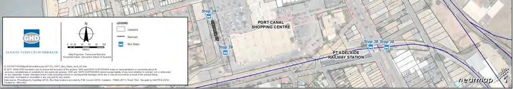
98 Figure 58 Existing Bus Stops in the Port Adelaide Centre 90


99 Significant pedestrian activity occurs along Commercial Road where an on-street bus interchange, comprising of two major bus stops, is located. The bus interchange has two bus stops on either side of Commercial Road as shown in Figure 59. Figure 59 Bus Stops at the Bus Interchange in Commercial Road south of St Vincent Street Bus stop waiting area in Commercial Road near the Port Mall laneway Bus stops on the west side of Commercial Road Future Public Transport Future public transport options in Port Adelaide require further investigation that is beyond the scope of this parking and movement study. Some suggested initiatives for improved public transport infrastructure and services are shown in Figure


100 Figure 60 Future Public Transport Options in Port Adelaide Source: UBD map 2010 modified by GHD 92


101 These options are discussed as follows: Currently the Port Adelaide bus routes have the major stops in Commercial Road. A new off-street bus interchange could be investigated for the terminating bus services at Port Adelaide. The best location for this facility is to be determined, but it could consider place making opportunities in the immediate vicinity of the interchange. It needs to be designed as a safe people-focused facility adjacent to an area of activation. New locations for an off-street bus interchanges should be investigated in more detail. Alternative locations for a bus interchange or terminus in Port Adelaide are shown in Figure 61. Figure 61 Locations to Consider for a Bus Interchange or Terminus in Port Adelaide The bus layover area on the north side of North Parade near McLaren Wharf is a potential bus stop terminus A section of Portland Place immediately north of the Port Adelaide railway station could be considered for an interchange site The electrification of the railway from Adelaide to Port Adelaide and the Outer Harbor station is planned to be completed by Train services to the Port Adelaide and Outer Harbor stations are scheduled to operate every 15 minutes. The expansion of the light rail network as part of the Coast to Coast tram network from Glenelg to the City and the Entertainment Centre and then on to Port Adelaide and Semaphore was announced in the 2008 State Government budget. The tram line from Adelaide to Port Adelaide and Semaphore is currently planned to be completed by 2018/2019. The final tram station locations and alignments through Port Adelaide have not been confirmed and are being studied by DTEI. Two tram alignments via the Jervois Bridge were discussed: Option 1 via Commercial Road, St Vincent Street and the Jervois Bridge to Semaphore. Option 2 via the freight rail spur east of the railway museum, Baker Street, St Vincent Street and the Jervois Bridge. An alternative tram alignment via the Birkenhead Bridge to Cruickshank s Corner is along St Vincent Street and Nelson Street. This alignment requires further consideration as this may require the Birkenhead Bridge to be permanently closed for shipping and boats so that tram services are not disrupted. The structural integrity of the bridge also needs to be assessed for tram operations. This alignment over the Birkenhead Bridge may not be a viable route for the trams due to the potentially high costs of upgrading the Birkenhead Bridge. 93
102 In the long term; transit-oriented development with a mixture of high density residential and commercial development is encouraged within the walkable catchment area of the Port Adelaide railway station. The Port Adelaide railway station will need to have good pedestrian linkages from the area immediately surrounding the station and good connections with the local bus network in Commercial Road. Patronage at Port Adelaide station will be encouraged with walking and cycling as the primary access mode. 5.3 Pedestrian Movements Areas that are considered most likely to have relatively high levels of pedestrian activity are shown in Figure 62. The red circles on the plan indicate the busiest crossing for pedestrian movements in St Vincent Street, Commercial Road and Dale Street. Much of the pedestrian activity occurs between the car parking areas and the key attractors in the Port Adelaide Centre, such as: Employees and visitors to the Council offices, other small businesses and offices. Employees and shoppers to the supermarkets and shops in the two shopping centres and along Commercial and St Vincent Street. Visitors and tourists to the cafes, restaurants, shops and museums in Port Adelaide. During a typical weekday, most of the pedestrian activity occurs mainly to and within the Port Mall and Port Canal precincts. During the weekend, more pedestrian movements occur about the Waterfront and Museum precincts with visitors and tourists to Port Adelaide. Specific pedestrian hotspots for high pedestrian activity and unsafe pedestrian movements are described in further detail in the following sections. Figure 62 Key Pedestrian Access Ways in the Port Adelaide Centre Source: Nearmap 2010 modified by GHD 94


103 5.3.1 Pedestrian Access in the Port Canal Shopping Centre Precinct south of Dale Street Passengers who arrive at the Port Adelaide railway station must walk along a long reverse directional pedestrian ramp at the station and then approximately 150 m to access the first entrance of the Port Canal shopping centre, as shown in Figure 63. No directional signage is provided to assist pedestrians to walk to the shopping centres, businesses or museums in Port Adelaide. Lighting is only provided in the immediate vicinity under the railway station viaduct and in Commercial Road, and not along the walking link to the shopping centre. At night it is considered unsafe and undesirable for people to walk in the dark to and near the railway station. The pathway also leads to the rear of the Port Canal shopping centre which does not encourage safe pedestrian movements. Figure 63 Pedestrian Access near the Port Adelaide Railway Station Pedestrian walkway between the railway station and the Port Canal shopping centre Laneway leading from railway station to the southeast corner of the K-Mart store Wayfinding signage for pedestrians at the Port Adelaide railway station is quite poor as shown in Figure 64. Figure 64 Poor Wayfinding near the Port Adelaide Railway Station No wayfinding signage leading pedestrians north along Commercial Road to the iconic lighthouse Poor wayfinding signage at the railway station in Commercial Road for visitors to Port Adelaide 95


104 Pedestrian access at the Port Canal shopping is provided through the car parking area or via a section of former east-west internal road through the shopping centre, as shown in Figure 65. Figure 65 Pedestrian Access within the Port Canal Shopping Centre Pedestrian access from the western car park to the Port Canal shopping centre Former local east-west access road at the Port Canal shopping centre was closed for a pedestrian only area between the Coles and Woolworth s sections of the mall Pedestrian access along Church Street immediately west of the Port Canal shopping centre is not a continuous section of footpath. Pedestrians walking in a north-south direction along Church Street must walk through the edge of the off-street parking area or along the street, as shown in Figure 66. Figure 66 Pedestrian Access along Church Street and from the Port Canal Mall to Dale Street Poor pedestrian access along the eastside of Church Street south of the Council library Laneway from Dale Street into the southern entrance of the Port Canal shopping centre Pedestrian Access in the Port Mall Shopping Centre Precinct north of Dale Street The existing pedestrian crossing on Dale Street is provided for safe pedestrian movement between the two shopping centres. However, this crossing leads into a narrow walkway section which has poor lighting and is a security concern, as shown in Figure 65. This walkway leads directly into the rear entrance of the Port Canal shopping centre. 96


105 The crossing on Dale Street directs pedestrian traffic towards the Port Mall shopping centre directly into the car park area, as shown in Figure 67. No obvious path leads pedestrians directly towards the entrance of the Port Mall shopping centre and pedestrians are likely to walk through the car park. Figure 67 Pedestrian Access between the Port Mall and Port Canal Shopping Centres Pedestrian access across Dale Street looking south from the Port Mall North-south pedestrian crossing over Dale Street between the shopping centres Pedestrian access along the western periphery of the Port Mall where the Mitre 10 and Cheap as Chips stores are located has been upgraded to provide a better north-south link between Quebec Street and Dale Street on the west side of the car park. Pedestrian access within the Port Mall shopping centre has been improved with a new courtyard area along the southern side of the mall linking to Robe Street and St Vincent Street at the western end of the Port Mall and immediately north of the Foodland supermarket leading to the laneway linking to Commercial Road as shown in Figure 68. Figure 68 Improved Pedestrian Links within the Port Mall Shopping Centre An upgraded Quebec Mall on the south side of the Port Mall leads through to St Vincent Street via the western end of the Port Mall East-west under-cover pedestrian way between the Foodland supermarket and the Port Mall 97


106 Pedestrians commonly jaywalk across Commercial Road from the Port Mall to get to the bus stops on the east side of the street. This is a safety hazard with potential pedestrian/vehicle conflicts. A formal pedestrian refuge exists at this part of the street to provide safe pedestrian movement across to the eastern bus stops adjacent to the laneway to the Port Mall shopping centre. The laneway from Commercial Road leading to the Port Mall is shown in Figure 69. It does not provide an attractive entryway to the shopping centre and is potentially a security issue for pedestrians at night and when the shops are closed. Figure 69 Pedestrian Access between the Port Mall and Commercial Road Looking east along the laneway from the Port Mall to Commercial Road Looking west across the pedestrian refuge in Commercial Road towards the Port Mall laneway Pedestrian Access in the Council Office and McLaren Wharf Precinct A pedestrian-actuated signal is located in St Vincent Street immediately west of the Port Mall entrance, as shown in Figure 70. This crossing allows pedestrians to move safely between the Council Offices on the north side and the Port Mall on the south side. This crossing is designed in stages across each side of the road with a median in St Vincent Street. It provides good access between these two locations as pedestrians can move mostly under-cover along the street to the Port Mall entrance. An outdoor pedestrian link also exists between the Quebec Mall and St Vincent Street. This is actually a no through road which terminates with a paved area to the north of the Port Mall shopping centre car park. Figure 70 Pedestrian Access between Port Mall and Council Offices Pedestrian-actuated signal at the staged crossing of St Vincent Street Looking east along St Vincent Street with the median and pedestrian crossing 98


107 5.3.4 Pedestrian Access in the Precincts east of Commercial Road and along the Waterfront Pedestrian activity east of Commercial Road and north of St Vincent is less busy, except during Sunday market days and for tourists walking to the museums. On weekdays the pedestrian activity is mostly workers going to their offices or visitors to the businesses in this part of Port Adelaide. The activity is low and dispersed because people are parking for several hours to conduct mostly indoor activity at offices or museums. Examples of the low level of pedestrian activity in the streets east of Commercial Road are shown in Figure 71. Figure 71 Pedestrian Access east of Commercial Road Low pedestrian activity along Divett Street near the SA Maritime Museum on a typical weekday Gaps in the median for pedestrians walking along Lipson Street towards the waterfront The pedestrian access is also quite low along the waterfront on weekdays and in the TAFE precinct, as shown in Figure 72. The amenity for pedestrians in these areas could be improved with more seating, public artwork and plantings. Pedestrian access between McLaren Wharf and the TAFE precinct across Nelson Street could also be improved with new footpath treatments and wayfinding signage. Figure 72 Pedestrian Access north of St Vincent Street Pedestrian access along the Port Adelaide River waterfront at McLaren Wharf Nelson Street is a visual barrier for pedestrians walking between McLaren Wharf and the TAFE 99


108 5.3.5 Summary of Pedestrian Movement Issues Much of the pedestrian movement that occurs around the Port Adelaide Centre occurs on local footpaths. However, there are a number of locations where pedestrian movements occur across private properties and other parcels of council land. Pedestrian linkages are often under-developed as shown in Figure 73. Key issues at these locations include: Lack of pathway continuity Lack of directional signage Security concerns Figure 73 Under-Developed Pedestrian Links at Various Locations 100
109 6. Future Car Parking Demand 6.1 Development of a Strategic Parking Policy The location, supply and pricing of parking affects development opportunities, property values and urban form. It plays a key role in land use accessibility and the economy of major centres, such as the Port Adelaide Centre. Parking is a major land use and therefore availability of parking usually depends in large on the intensity of the development and the cost of land. Management of parking supply is a balancing act, and it is achieving the appropriate balance that is at times difficult. As a guiding principle: A parking system operates at optimum efficiency when it is being used at slightly less than full capacity. Optimum capacity is generally accepted as being 85 to 95 per cent. Source: Albury City Car Parking Strategy , City of Albury, New South Wales, August 2010, page 9. Too much parking, particularly if provided on surface lots uses valuable land resources and often results in widely-spaced and disconnected development patterns. Conversely, too little parking or poorly designed or located parking can result in parking spill over to adjacent areas, leading motorists to choose alternate destinations and it can deter development. Council acknowledges parking to be an issue in the Port Adelaide Centre and understands the importance of providing a balanced supply of parking to support the progressive revitalisation of the Centre. Council initiated this Car Parking and Movement Study as the first stage to fully understand the current car parking situation and the issues and opportunities with meeting future demand based on known development scenarios. The outcomes from this study will be used to inform the future development of a Car Parking and Movement Strategy for the Port Adelaide Centre. The types of parking activity within the Port Adelaide Centre include: Employees who visit Port Adelaide for employment on weekdays. Shoppers to the shopping centres and other shops. Visitors for business and personal appointments that have a short term parking requirement on weekdays. Tourists to the waterfront, cafes and museums. The future car parking demand and analysis discussed in the following sections was developed by considering these different user groups, the information provided by LMC for the McLaren Wharf and waterfront precinct, comments from the key stakeholders and an assessment of the existing car parking supply and demand. 6.2 Future Directions for Car Parking in the Port Adelaide Centre The revitalisation of the Port Adelaide Centre is a major focus of Council. Current initiatives and opportunities include: The McLaren Wharf Masterplan for LMC. The Masterplan study area is located within a portion of Policy Areas 22 and 27 and includes Council s own offices and civic centre, Black Diamond Square and privately owned strategic properties with the capacity of accommodating a significant increase in 101
110 residential population, major hotel, offices, restaurants, tourism facilities and other uses over the next 10 to 20 years. In order to maintain the predominance of pedestrian access, public spaces and high quality private/public interfaces, it is expected that there may be a car parking shortfall in this precinct requiring a multi-level parking complex of some significance. The renaissance of the wider heritage precincts which comprise a range of heritage buildings throughout Policy Areas 22 and 26 comprising offices, warehouse and other mixed uses. In 2006, Council commissioned Jones Lang Lasalle and McIntyre Scarborough Robertson to review the extent of commercial stock within the Port Adelaide Centre. The majority of such stock is situated in the heritage precincts and totals 63,000 m 2 with a vacancy rate of 20 per cent (or 12,000 m 2 ). It is observed that this market has remained stable over the intervening period and would reflect the current situation. The current demand analysis identifies no shortage of car parking to support the current occupancy level. However, if this vacant stock was redeveloped and occupied through a renaissance of the Port Adelaide Centre where the greater majority of such stock is within heritage buildings with high levels of site coverage, a shortfall in car parking provision could result which could not be delivered by a market solution due to fragmented ownership and the nature of heritage restrictions. Certain portions of the Newport Quays development, in particular Dock One in the eastern part of the study area, provide opportunities for new businesses and population in the Port Adelaide Centre. While this development is subject to review in the planning process, it is expected that there will be adequate provision for all direct car parking requirements within the development. Nonetheless, it is likely this will be a catalyst for infill development along the wharf and provide parking for the north eastern portion of the Heritage Waterfront precinct. A comprehensive redevelopment of the two retail centres (Port Mall and Port Canal shopping centres) would affect the demand for car parking in the Port Adelaide Centre. The car parking for such redevelopment will be provided by the owner/developer of either centre and therefore parking will be designed and structured to benefit the respective retail centre and its applicability to adjoining properties is likely to be extremely limited. Parking to support the businesses in Commercial Road and St Vincent Street properties is expected to be limited. Multiple agencies will, therefore, need to work together to provide access, car parking and permeability of movement to avail a wider precinct benefit. This will be paramount to a successful integrated centre. Other peripheral activity nodes around the Port Adelaide train station, the Gateway site on Commercial Road and the TAFE site are expected to provide self-contained car parking solutions. Although key waterfront projects, such as the McLaren Wharf precinct and the Dock One development, are in the planning and early implementation stage, no major developments are currently approved for construction in the immediate future. 6.3 Future Public Parking Demand by Precinct An analysis of the future parking demand by precinct is provided in this section. The demand for additional public parking has been identified and determined for the following areas in the Port Adelaide Centre: St Vincent Street and Commercial Road businesses McLaren Wharf precinct currently being planned by LMC 102
111 Dock One development which is on hold due to environmental issues with the close proximity to the industries on the north side of the Port Adelaide River The potential expansion of the Port Canal shopping centre was excluded from the assessment because it is assumed that the development application will require sufficient car parking to cater to the shopping centre development west of the Woolworths supermarket. The timing of these developments cannot be confirmed when this study was conducted in 2011, but they are more likely to occur in the medium to long term over a 5 to 20 year period. The following assumptions were made regarding the short, medium and long term car parking demand. The time periods for the short, medium and long term car parking demand assessment taken from the priority time periods used for LMC in the McLaren Wharf yield table and Masterplan assessment are: Short term from 2011 to 2016 Medium term from 2016 to 2021 Long term from 2021 to 2026 The future demand for car parking in the Port Adelaide Centre was calculated based on the assumption that the existing parking demand observed on a typical Thursday in March 2011 will grow by two per cent per annum over the three five-year time periods. The summary of the future car parking demand by precinct is given in Table 6. Table 6 Weekday Car Parking Demand Forecasts in the Port Adelaide Centre Precinct Development Area Existing Demand Time Frame Short ( ) Medium ( ) Long ( ) Total Estimated Parking Demand (1) Port Mall Port Mall and St Vincent St (2) Port Canal Port Canal and Commercial Rd (3) TAFE Commercial Rd north of St Vincent St (4) Council Office Commercial Rd north of St Vincent St (5) Heritage Waterfront Heritage Waterfront to Dock One (6) Railway Museum Railway Museum and Lipson St Total 1, ,
112 In June 2011, Leedwell Strategic conducted a high level assessment and commercial commentary on the proposed land use, demand, delivery, scale and car parking of the McLaren Wharf and Cruickshank s Corner Precinct Master Plan for LMC. The yield table for the proposed land uses in the McLaren Wharf and waterfront precinct from this assessment was used to estimate the additional future car parking demand for the Port Adelaide Centre as a result of this waterfront development. It only includes developments proposed under the Master Plan for LMC north of St Vincent Street and south of the Port Adelaide River. The car parking rates used in the car parking demand analysis were based on the rates used in the Leedwell Strategic parking analysis of June 2011 (used only for the purpose of this analysis and not available to Council). The car parking rates used in the calculations of the future car parking demand estimates are provided in Table 7. Table 7 Car Parking Rates Used for the Future Car Parking Demand Analysis Land Use Type Spaces Per Unit Hotel 0.5 spaces per apartment Retail 5.0 spaces per 100 m 2 Commercial (Office) 4.0 spaces per 100 m 2 Residential 1.0 spaces per unit Source: McLaren Wharf and Cruickshank s Corner Precinct Yield Tables and Master Plan Assessment, Leedwell Strategic. June 2011 (used only for the purpose of this analysis and not available to Council) The car parking rates were adjusted based on the following assumptions: Hotel Retail Majority of parking provided on the site, however, a component can be provided off site for staff parking and or valet parking. Parking must be provided within very close proximity determined by market expectations and security issues for use after hours, such as restaurants, cafes etc. The Master Plan should allow for car parking on each retail site or linked to an adjoining site with secure egress. Commercial (Office) Provided on site or within close proximity of less than 100 m. Residential Secure parking must be provided within very close proximity with on-site parking or via an adjoining site with a secure access point. Public parking to be separated from residential private parking. 104
113 The additional car parking demand in the Port Adelaide Centre as a result of the proposed retail, commercial, hotel and residential land uses in the McLaren Wharf and waterfront precinct was calculated based on the car parking rates provided in Table 7. The car parking demand estimates for this additional future development are grouped by time frame and precinct in Table 8. The sites referred to in Table 8 are shown in Figure 74. Table 8 Additional Car Parking Demand from the McLaren Wharf Yield Table Precinct Site Time Frame Hotel (units) Retail (m 2 ) Commercial (m 2 ) Residential (units) Estimated Parking Demand (3) TAFE B23 Long 1,100 4, (4) Council Office B24 Short 2, (4) Council Office B25 Short 834 3, (4) Council Office B26 Medium 305 2, (4) Council Office B27 Medium (4) Council Office B28 Custom s House Short 4, (5) Heritage Waterfront B29 Wharf Medium 2, (3) TAFE Site A Long 1,130 1, (3) TAFE Site B Long (5) Heritage Waterfront Site C Long Total ,320 14, ,566 Source: McLaren Wharf and Cruickshank s Corner Precinct Yield Tables and Master Plan Assessment, Leedwell Strategic. June 2011 (used only for the purpose of this analysis and not available to Council) 105


114 Figure 74 Sites Used in the McLaren Wharf and Cruickshank s Corner Precinct Yield Tables Source: McLaren Wharf and Cruickshank s Corner Precinct Yield Tables and Master Plan Assessment, Leedwell Strategic. June 2011 (used only for the purpose of this analysis and not available to Council) 106

115 A comparison of the existing car parking capacity in March 2011 to the estimated weekday car parking demand for the short term until 2016 is shown in the Port Adelaide Centre by precinct in Figure 75. The car parking demand on a typical weekday is expected to exceed the parking capacity in the Council Office precinct where the McLaren Wharf development will occur. Therefore, if the development at McLaren Wharf proceeds in the next five years, additional car parking will need to be provided. All other precincts show sufficient car parking capacity for the estimated future parking demand. Figure 75 Comparison of Parking Capacity to Future Car Parking Demand in the Port Adelaide Centre for the Short Term Scenario 107

116 A comparison of the existing car parking capacity in March 2011 to the estimated weekday car parking demand for the medium term until 2021 is shown in the Port Adelaide Centre by precinct in Figure 76. The car parking demand on a typical weekday is expected to exceed the parking capacity in the Council Office and Heritage Waterfront precincts where the McLaren Wharf development will occur. Therefore, if the proposed developments at McLaren Wharf and Heritage Waterfront precincts proceed over the next ten years, additional car parking will need to be provided in these areas north of St Vincent Street. All other areas show that the car parking capacity is sufficient for the typical demand for car parking on weekdays. Figure 76 Comparison of Parking Capacity to Future Car Parking Demand in the Port Adelaide Centre for the Medium Term Scenario 108

117 A comparison of the existing car parking capacity in March 2011 to the estimated weekday car parking demand for the long term until 2026 is shown in the Port Adelaide Centre by precinct in Figure 77. The car parking demand on a typical weekday is expected to exceed the parking capacity in the Council Office, Heritage Waterfront and Port Adelaide TAFE precincts where the McLaren Wharf development will occur. Therefore, if the proposed developments at McLaren Wharf and Heritage Waterfront precincts proceed over the next 15 years, additional car parking will need to be provided in these areas north of St Vincent Street. All other precincts show sufficient car parking capacity for the estimated future parking demand. Figure 77 Comparison of Parking Capacity to Future Car Parking Demand in the Port Adelaide Centre for the Long Term Scenario 109
118 7. Funding Mechanisms for Additional Car Parking In this section, various funding mechanism for car parking are discussed and a recommendation is provided. 7.1 Background to the Port Adelaide Centre Car Parking Fund The Port Adelaide Centre Car Parking Fund (the Fund) was established pursuant to Section 50(a) of the Development Act in 1993 at the instigation of Council and approved by the Minister for Urban Development and Planning and gazetted on 10 August The intent of the Fund is to assist with the provision of adequate car parking in the Port Adelaide Centre and to assist with the revitalisation of the Port Adelaide Centre. The boundaries to which the fund applies are shown in Figure 78. These were revised in April 2009 and include the following policy areas designated in the Port Adelaide Enfield (City) Development Plan: Policy Area 22 Port Adelaide State Heritage Policy Area 23 Core Policy Area 24 East End Policy Area 26 Port Centre Main Street Historic Conservation Policy Area 27 McLarens Wharf Policy Area 30 Southern Gateway Key elements of this car parking fund are listed as follows: Development proposals can satisfy car parking requirements by making a financial contribution to the fund in lieu of the provision of car parking spaces on the site by mutual agreement. The contribution fee for a car parking space is based on a percentage of the actual cost of providing a car parking space and is used to assist with the provision of car parking in this area. The development may proceed despite the shortfall of car parking at the site of the development. The developer does not have claim to the car spaces, exclusive use or ownership and cannot trade them as an asset. Clients and employees of the development cannot have reserved or guaranteed use of the spaces. Council may receive car parking fee and/or fine income from the spaces. Council may generate income in other forms through the development of air space or portions of land initially acquired with contributions. The contribution in lieu of a car parking space is currently $7,200 per space and is subject for annual review. The fund will need to be augmented with additional funds to enable timely construction of public car parking spaces. A detailed Car Parking Strategy will be prepared by Council to guide the location, priority and funding arrangements for the provision of public car parking spaces. 110


119 The Port Adelaide Centre Car Parking Fund may be used to: Ensure that the car parking is positioned in suitable locations, to achieve desired urban form. Provide car parking facilities within the designated area. Maintain, operate or improve car parking facilities within the designated area. Establish, maintain or improve transport facilities within the area of the Council with a view to reducing the need or demand for car parking facilities within the designated area. Figure 78 Areas Within the Port Adelaide Centre Car Parking Fund Source: Port Adelaide Car Parking Fund, Development Guideline No. 12, City of Port Adelaide Enfield, April 2009 The Fund is a planning instrument that was created as one option to satisfy the statutory obligations of parking provision associated with both new and refurbishment forms of development. From the land owner/developer or tenant s perspective, irrespective of discharging statutory obligations, most businesses need to provide parking for staff, customers and visitors in order to sustain a viable business. 111
120 Since 2006 when the Fund policy was established and in the context of a very limited growth period for the Port Adelaide Centre, the Fund has been potentially applicable to three smaller scale development applications. However, on all occasions the applicant has either found alternative parking options, not proceeded or satisfied its car parking obligations through other means. To date, the Fund has received no contributions. Given the mandate of Council to foster development and business, Council planners have adopted the following pragmatic approach: Review each development application. In determining the amount of car parking needed to meet the requirements of the Development Plan, Council will consider not just the numerical rate per land use as listed in the Plan, but also the availability of other on-street and off-street car parking spaces in close proximity. For proposed changes of use to existing historical buildings, it will consider that these buildings have operated with an accepted shortfall of parking and not try to redress this historical shortfall through re-use proposals. If a definite shortfall exists, the Fund may apply as a negotiated arrangement with the applicant. The Fund is not an automatic appropriation, but a last resort option. To date, Council has had no active participation as an interventionist in the marketplace in respect of facilitating car parking provision nor developed a strategy for same (i.e. a plan of actual car parking provision in terms of location, quantum, access, funding options, financial viability, partnership strategies etc.) and therefore any payments that might be contributed to the Fund are not linked to designated or identifiable outcomes or projects which support business sustainability and focus development activity. It is noted that the contribution is set at $7,200 per car space which is estimated at approximately 25 to 30 per cent of actual car parking provision. This is considered to be broadly in line with market cost with a single car space in a multi-deck parking facility estimated at about $30,000 for land and construction. 7.2 Review of the Port Adelaide Centre Car Parking Fund The following documents and commentary sources were reviewed: Council Policy - Port Adelaide Centre Car Parking Fund Port Adelaide Centre Car Parking Fund Development Guide No.12 Report to Council (2010) Port Adelaide Centre Car Parking Fund Policy Review Port Adelaide Centre Car Parking Fund Policy, Report to Council 10 February 2009 Policy Review Port Adelaide Centre Car Parking Fund Policy, Report to Council 12 February 2008 Port Adelaide Centre Car Parking Fund Report to Council 16 May 2006 In addition, consultation was undertaken with Council staff to understand the history and rationale of the Fund and to discuss current issues with the Fund. There is a concern that development scenarios where the Fund may apply are often small businesses with high tenancy turnover and very marginal investment in properties or fit-out. Feedback from these types of applicants has highlighted the cost of the Fund contribution as a critical element for viability in the Port Adelaide Centre. 112
121 Fund contributions were originally waived in Policy Area 26 (fundamentally properties fronting Commercial Road and St Vincent Street) due to implications of heavy traffic prior to the construction of the Tom Diver Derrick bridge which was opened for traffic in August However, the Fund contribution waiver remains due to low market demand for tenancies along such road frontages. In 2009, Council sought to suspend the Fund, however the Fund remains as originally gazetted. In the last two years, the Parking Fund policy has not been applied to any development applications. Council is again seeking further consideration of the Fund and this report will be used to inform that consideration. Concerns have been raised by Council, property owners and businesses that the Fund has not been applied over the past five years and it is a disincentive for new businesses to establish in the Port Adelaide Centre. In order to address the issues, Council has considered changes to the Fund policy including fee reduction, fee waiving and suspension due to perception of the Fund s impact as a disincentive to new business growth and/or development in the Port Adelaide Centre. The purpose of this review is to provide an independent assessment of the Fund and provide strategic recommendations for its application on an ongoing basis. The Policy, Development Guide and annual Policy Review to Council provide a detailed review of the structure and details of the Fund which are provided in the attachments to the Council reports. 7.3 Port Adelaide Centre Car Parking Fund Council Grant Scheme In July 2011, Council adopted the Port Adelaide Centre Car Parking Fund Council Grant Scheme. The grant scheme provides Council the ability to assist development applicants meet the cost of providing a financial contribution to the Fund where Council and an applicant have agreed that a financial contribution in lieu of off-street car parking is appropriate. Council may exercise discretion in the approval of a grant in accordance with criteria that aligns with its strategic objective to revitalise the Port Adelaide Regional Centre. Applications for a grant can only be made to the Council after an applicant for development authorisation under the Development Act, 1993 has reached agreement with the Council acting as a relevant authority under that Act on the amount to be paid to the Fund in lieu of the provision of car parking spaces. As advised by Council s solicitors a discretionary grant scheme may be established whereby the whole or part of the amount of the required Fund contribution can be made into the Fund through a grant scheme. The process is subject to specific considerations and restrictions. 7.4 Funding Options for Increased Public Car Parking Balanced and adequate public car parking is required to support the revitalisation of the Port Adelaide Centre. It may occur in many forms, time horizons and funding sources. The City of Port Adelaide Enfield must consider its role in the provision of this public car parking by carefully considering the commercial risks, exit strategies and other mechanisms in the establishment of additional car parking for the Port Adelaide Centre. This must be balanced with the aspirational goals to encourage more sustainable transport modes, such as public transport, walking and cycling. 113
122 It is important to identify at this stage, that any car parking involvement must be under-pinned by a sustainable commercial platform which enables Council to take a market leadership role without an undue financial burden and to be in a position to exit the role when self-sufficiency or growth targets are achieved. It also important to note that such a role is not necessarily about capital and debt contribution, nor necessarily reliant on charging the general public for car parking. There are at least nine potential funding sources which could be applied to secure an appropriate and balanced contribution structure by various partners, stakeholders, owners, businesses, ratepayers, statutory backed revenue sources and others. These may vary across different precincts and be under-pinned by pre-commitments from key elements of the Port Adelaide Centre growth phase and apply at different times of the growth cycle. A summary of nine public car parking funding options is provided in Table 9 with a short description of the context and contributor and a discussion of the key issues and benefits. 114
123 Table 9 Public Car Park Funding Options Funding Mechanism Context Contributor Key Issues Benefits Car Parking Fund Statutory Mechanism pursuant to Section 50(A) of the Development Act Individual Developer / Tenant at time of development where required car parking is not able to be assembled on site Upfront contribution by Developer / Owner / Tenant (whoever is the applicant) Statutory mechanism to technically satisfy provision of car parking. Does not necessarily provide actual car parking supply (if not facilitated by Council) and is a financial contribution only. Therefore this does not necessarily provide car parking to under-pin business sustainability which is the primary goal of centre revitalisation. Generally resisted in the private marketplace because the monetary contribution is not linked to supply of parking and no strategy of supply is demonstrated. Contributions of low level cost only in total. This is unlikely to be sufficient to deliver the actual car parking requirements. It is an accumulated fund over time and is inherently not an infrastructure catalyst revenue source. Technically enables an owner, developer or tenant to contribute to car parking provision where it is not possible to provide actual parking as is the case with Port Adelaide s heritage precincts and Commercial Road fronting properties, where sites are small, land locked, built form is high percentage coverage etc. Success requires an advanced strategy and implementation (ahead of development) by Council for cost effective parking provision in proximity of contributing new development/business which under-pins user requirements. Generally applies to smaller developments/ business only. 115
124 Funding Mechanism Context Contributor Key Issues Benefits Developer Funded Developer provides a total car parking solution on the developers site at its cost (capital and operational) Individual Developer Upfront contribution by Developer/Owner at the time of development Inherently amortised into tenant s rent base Car parking designed to maximise benefits to the owner/tenants of the defined property for the exclusive use of customers, staff and authorised users not generally available to the public on a wider precinct support basis. Development designed to maximise integration of parking and access and direct links to the primary business areas. Car parking is provided by the developer at no cost to the Council. Fully funded by the owner/developer. Designed to future proof the sustainability and viability of the tenants and asset value and growth of the asset. In larger centres, effort put into design and management to protect from competition from other centres. 116
125 Funding Mechanism Context Contributor Key Issues Benefits Capital Funded (Council) Capital budget allocation by Council All ratepayers of Port Adelaide Enfield municipal area Opportunity cost over other demands for capital resources in the municipal area. Must be linked to priority policy objective/strategy of Council to justify expenditure. Potential major capital item (i.e. $millions) in any given financial year. Capital commitment under-pins sustainability particularly in initial stages of life cycle of car parking where Council seeks to act as an economic development catalyst. May be under-pinned by future revenue. Provides a guaranteed up front commitment. Invested in asset ownership (assuming in Council s ownership). 117
126 Funding Mechanism Context Contributor Key Issues Benefits Debt Funded (Council) Raise debt funds in the commercial market or utilise existing facility to fund additional car parking All ratepayers of Port Adelaide Enfield municipal area Debt on balance sheet of Council. Impact on financial strategy of Council - and must be linked to priority policy of Council to justify debt commitment. Most logically, would need to demonstrate prudential framework (sustainability) for debt funds to be repaid (principal and interest) over a reasonable period of time. Ability to achieve scale of car parking provision for key projects in the short term. Spreads the contribution over a wider responsibility than just owners and tenants in the Port Adelaide Centre in initial stages of centre revitalisation when affordability (and political acceptability) is lowest. Applicable where sustainable revenue sources are demonstrated and invested within an asset retained by Council. 118
127 Funding Mechanism Context Contributor Key Issues Benefits Special Purpose Levy Special Purpose Rate Levy pursuant to the Local Government Act Limited to ratepayers in a designated area (i.e. Port Adelaide Centre Policy Areas) Statutory enforceable cash flow The primary issue for a no-growth or low-growth centre is the additional cost borne by ratepayers and the acceptability both commercially and politically. Can be inequitable for owners/tenants who do provide adequate parking (seen as a double cost obligation) and major owners (i.e. primary retail core owners) who are major rate paying entities who bear the greater financial cost. Most applicable to centres under revitalisation and where major property owners are partners to an integrated scheme of car parking provision. From a commercial basis, once established, contributions are enforceable and guaranteed under the Local Government Act and can be targeted to owners and businesses that directly benefit from the car parking provision. Provides low risk guaranteed cash flow to under-pin debt. Must be under-pinned by actual provision of car parking by Council (not a quasi-fund accumulation mechanism). 119
128 Funding Mechanism Context Contributor Key Issues Benefits Partner Funded Land or other equity contributions provided by strategic partners Strategic partners (Government, major corporates, key retail owners) Fundamentally requires major long term owners contributing land or use of land for further development of car parking because of a vested long term interest in the growth of the Port Adelaide Centre. Generally this comprises a requirement for Council to develop car parking and to commit capital on third party land. Most likely contributors will be government via head leasing of land on a peppercorn basis for a strategic car parking purpose to support major centre revitalisation objectives. May apply to core retail owners where Council is able to develop additional car parking, building on existing infrastructure for a wider precinct benefit. May extend to capital contribution for core Government activities (such as for park and ride sites at railway stations). 120
129 Funding Mechanism Context Contributor Key Issues Benefits User Funded Car parking funded by corporate or public users Corporate owners/tenants, visitors, residents, general public Opportunities are in two categories; long term fixed and discretional which present fundamentally different opportunities and risks: 1. Long term fixed users (i.e. grouped valet parking for adjoining hotel business, Council s own requirements for staff/visitors, overflow parking for long term residents, long term parking for adjoining office users), where commitments are on a long term lease (commercial) basis and linked to wider investment in the centre and providing guaranteed tenure and cash flow from substantial entities. 2. Discretional user (i.e. visitors, retail customers, tourists, general public) where commitment to contribution on a user pays basis can be fragile and price sensitive (particularly currently). Ability to secure corporate and long term users to under-pin viability and pre-commitment of multi-deck parking as a primary development risk mitigation. Discretional or occasional users can provide significant cash flow if the adjoining properties are established and likely to be remain as is. Proximity is a key criteria for discretional users and requires a significant draw card attractions in the wider precinct (i.e. significant restaurant precinct, tourism activities, etc). Unlikely to apply for general retail customers who expect free parking. Land Provision Existing land provided by Council Technically all ratepayers of Port Adelaide Enfield municipal area, but a balance sheet allocation only (not an actual cost going forward) Council having existing land in the required location. Alternative competing uses for the land. Possible multiple uses for the land (car parking and other core Council/community use). No actual cost (capital or debt) to Council utilises existing assets for strategic purpose of providing car parking. 121
130 Funding Mechanism Context Contributor Key Issues Benefits Combination of the above Any hybrid of the above options Funding and contribution tailored to achieve a solution in a specific policy area Opportunity to tailor solutions relative to individual precincts or policy areas and balance contributions based on equity principles. Reduces risk of each of the above options. Provides the most logical avenue where multiple parties (all ratepayers, beneficial ratepayers, users, partners and others) make a balanced contribution. Structured to ensure commercial sustainability between discretional and regulatory controlled funding sources. Can be varied / changed / adapted in contributions over time as the centre develops (i.e. may commence as a higher percentage of debt/capital and evolve to a levy based contribution once growth and benefit to designated owners/business is substantiated). 122
131 The applicability of the car parking funding options to increase the capacity for public car parking are provided in Table 10. Table 10 Applicability of Public Car Park Funding Options Funding Mechanism APPLICATION TO: Major Car Parks (100+) Multi-deck Minor Car Parks Car parking fund Yes minor contribution Lesser Developer funded Yes Yes Capital funded (Council) Yes Yes Debt funded (Council) Yes No Special purpose levy Yes Limited Partner funded Yes No User funded Yes Limited Land provision Yes Yes Combination of above As applies As applies 7.5 Port Adelaide Car Parking Fund Recommendations The following recommendations are made with respect to the Port Adelaide Car Parking Fund: 1. Based on the discussions with the key stakeholders and the objective of attracting new businesses to Port Adelaide, the Fund should be revised so that the monies collected should be used by the Council to improve transport infrastructure, such as footpaths and sustainable transport options in lieu of additional Council-funded car parking, within a specified time period. This will show contributors to the Fund that the money is being effectively used to cater for more employees, visitors and tourists to visit and do business in the Port Adelaide Centre. It may be appropriate to reflect this in Council s Port Adelaide Centre Car Parking Fund Policy. 2. Acknowledge that whilst the primary policy objective of the Fund is to assist in the orderly development and revitalisation of the Port Adelaide Centre, the Fund plays a very small strategic role in this regard. 3. Acknowledge that the Fund may, in time, provide a mechanism to generate a low level of contributory funds for car parking provision which may be beneficial to complement other funding avenues for the actualisation of parking provision. 4. Maintain the current significantly discounted commercial cost base for the parking fund at $7,200 per additional parking space, until significant growth in commercial development occurs in the Port Adelaide Centre. This will be demonstrated when reduced vacancy rates occur, particularly in the heritage precincts where an increase may be acceptable to reflect commercial rates. 123
132 8. Conclusions and Recommendations 8.1 Conclusions Based on the review of previous studies and policies relevant to the Port Adelaide Centre, the discussions about car parking and movement with the key stakeholders in Port Adelaide and the car parking, traffic and bus movement and pedestrian access assessments, the key issues and opportunities are summarised under the headings of public car parking, traffic, bus and cyclist movements, and the access and amenity for pedestrians Public Car Parking Over 3,600 public car parking spaces currently exist within the Port Adelaide Centre. Based on the car parking surveys conducted on a typical weekday and Sunday in March 2011, car parking in the Port Adelaide Centre in general is not considered a major problem with an overall utilisation rate of 53 per cent. Public car parking is considered adequate because there is a high turnover of spaces in the retail precincts of the Port Mall and the Port Canal shopping centres and the relatively short term demand for car parking spaces in the museum and heritage waterfront areas. An oversupply of parking exists on the periphery of the Port Canal shopping centre west of Church Street, south of Old Port Road and at the rear of the Coles and K-Mart stores north of the railway line. The availability of car parking spaces is only considered an issue in the following locations: Close to the McLaren Wharf area on weekdays when predominately Council staff use the unrestricted parking areas north of Nile Street and visitors to the Council, local businesses and the medical centre using the restricted 1 and 2-hour car parking spaces in Nile Street and Robe Street. In contrast, the paid 4-hour parking area at McLaren Wharf north of North Parade is under-utilised during weekdays. However, it is well used on Sundays during the Fishermen s Wharf markets and the other tourist activity near the lighthouse. Near the National Railway Museum in Lipson Street on weekdays. Employees who arrive for work on weekdays prior to 9 am use the off-street unrestricted car parking area immediately north of the museum entrance and consequently museum visitors and staff who arrive after 10 am often do not have spaces to park. Near the Port Mall during busy pre-holiday periods, especially with access to the upper deck of the former Coles parking area not available. Parking is not a problem at or near the TAFE precinct west of Nelson Street or in the Heritage Waterfront precinct east of the lighthouse and Commercial Road where an adequate supply of free unrestricted parking spaces exists in the off-street car parking areas. On-street parking is currently limited to 1 or 2 hours in these precincts during business hours for short term visitors and is considered adequate Traffic, Bus and Cyclist Movements With the opening of the Tom Diver Derrick Bridge in August 2008, the traffic volumes in St Vincent Street and Commercial Road have significantly decreased. This provides an opportunity to change the role of these streets through Port Adelaide to lower the speed limits, to make on-street parking easier to use and to improve the amenity and access for pedestrians and cyclists. 124
133 With three bus stops in Commercial Road between the railway station and St Vincent Street and an average stop spacing of less than 180 m, the rationalisation of the bus stops should be considered to improve the efficiency of bus operations and to provide safer pedestrian access between the bus stops and the signalised pedestrian crossings. The bus interchange in Commercial Road immediately south of St Vincent Street is located where significant jay-walking occurs to cross Commercial Road and to access the Port Mall via a laneway. This is considered a safety and security issue for bus passengers and pedestrians. Buses at the end of the trip terminate here or at a turnaround in North Parade next to the Fishermen s Wharf markets. If the terminating buses were located at a more suitable location away from Commercial Road, the kerb space immediately south of St Vincent Street could be used for shortterm parking to promote the businesses in this section of Commercial Road. Cyclist access to Port Adelaide is considered poor along Nelson Street, St Vincent Street and Commercial Road. The fast moving traffic along these streets without on-street bicycle lanes is an issue for safe cycling and deters cycling in the Port Adelaide Centre Access and Amenity for Pedestrians The pedestrian access network in the Port Adelaide Centre is not continuous, legible or provided with consistent footpath treatments, especially along the major pedestrian desire lines. Some of the laneways between activity points, such as between the railway station and the Port Canal shopping centre and the Port Mall and Commercial Road, are considered not safe for pedestrians at night or during times with little activity. The amenity for pedestrians along the busiest pedestrian desire lines, in particular in the north-south direction linking the railway station to St Vincent Street via Commercial Road or via the shopping centres is considered poor. The laneways for pedestrians are not attractive public spaces and discourage activity. Wayfinding signage, public lighting and visually interesting spaces with high quality public art are considered poor quality or are non-existent in many areas. 8.2 Suggested Short Term Measures The following short term measures are suggested to address the issues with public car parking, improve traffic, bus and cyclist movements and to improve the access and amenity for pedestrians in the Port Adelaide Centre. The following measures could be considered for implementation within the next three years Parking Measures to consider for improved public car parking are: Council to update the parking register, keep it updated and make it available in GIS mapping format. This action is a priority for the Port Adelaide Centre in particular. Provide consistent enforcement of parking through agreements with shopping centres and other land owners; Council should police parking on Council and private land in order to efficiently and consistently apply the 2-hour parking limits in the off-street car parking areas. 125
134 Car parking spaces to be clearly defined so the public are aware of where parking is available, the duration (all day or 2 hour) and the cost. This could be done by providing: Information boards at the entrance to the car parking areas. Information provided in tourist brochures and flyers, i.e. suggestions of where to park when attending tourist attractions. These could be distributed from Council, shopping centres, the Port Adelaide Visitor Information Centre and the tourist attractions, or on the Council s website. Investigate the potential to re-open the top deck of the Coles car park which currently has 120 unused spaces. It was closed for a variety of reasons including security and change of agreements with Council and these issues need to be discussed with the relevant parties to reach a resolution. Employees of Coles and Kmart stores should be required to park on the western side of Church Street. This must be enforced during peak periods such as before the busy Christmas and Easter shopping periods. Consider reducing all day parking to 2 and 4 hour parking in the car park north of the National Railway Museum which would make it easier for visitors to the museum to park. Employees who currently use this parking area would have to park in spaces along Lipson Street south of Godfrey Street or at the unrestricted Council parking area adjacent to Dock One north of McLaren Parade. Reinstate waterfront car parking to 4-hour parking on weekends and public holidays to service tourist attractions, in particular the dolphin cruises which run for four hours. With regards to the Port Adelaide Centre Car Parking Fund, the following recommendations are made: Based on the discussions with the key stakeholders and the objective of attracting new businesses to Port Adelaide, the Fund should be revised so that the monies collected should be used by the Council to improve transport infrastructure, such as footpaths and sustainable transport options in lieu of additional Council-funded car parking, within a specified time period. This will show contributors to the Fund that the money is being effectively used to cater for more employees, visitors and tourists to visit and do business in the Port Adelaide Centre. It may be appropriate to reflect this in Council s Port Adelaide Centre Car Parking Fund Policy. Acknowledge that whilst the primary policy objective of the Fund is to assist in the orderly development and revitalisation of the Port Adelaide Centre, the Fund plays a very small strategic role in this regard. Acknowledge that the Fund may, in time, provide a mechanism to generate a low level of contributory funds for car parking provision which may be beneficial to complement other funding avenues for the actualisation of parking provision. Maintain the current significantly discounted commercial cost base for the parking fund at $7,200 per additional parking space, until significant growth in commercial development occurs in the Port Adelaide Centre. This will be demonstrated when reduced vacancy rates occur, particularly in the heritage precincts where an increase may be acceptable to reflect commercial rates. 126


135 In order to simplify the parking zone controls for the Port Adelaide Centre, an area wide parking zone policy is recommended with consistent, more legible parking regulations. It would reduce the proliferation and clutter of parking signs. It would also reduce driver confusion and improve enforcement. It would be simpler for Council staff to maintain than the current policy of a complicated parking register and for Council officers to enforce the parking regulations. A proposed parking zone scheme for the Port Adelaide Centre is shown in Figure 79. It has three types of parking zones for the following parking controls: The Green Zone with a 2 hour limit from 8 am to 6 pm on weekdays and Saturdays and from 11 am to 5 pm on Sundays and public holidays. This zone regulation is designed to promote high turnover in the retail precincts. The Blue Zone with a 4 hour limit from 8 am to 5 pm on weekdays and Saturdays and from 11 am to 5 pm on Sundays and public holidays. This zone regulation is designed to cater for visitors and tourists in the Heritage Waterfront precinct and at the museum areas. The Yellow Zone with no time restrictions. These car parking areas would likely be used by employees and students on weekdays and tourists and visitors on weekends. They are located away from the high activity retail, business and heritage precincts and would require most people who park in these spaces to walk to their activity. Within the Port Adelaide Centre, loading zones and disabled car parking spaces would be exempt from these regulations and would have special signage designating them. Figure 79 Suggested Parking Zone Controls for the Port Adelaide Centre Source: Google map, 2011 modified by GHD 127
136 An easy to understand public information map could be produced explaining these regulations. An example of this type of area wide parking zone policy has been used very successfully in Brisbane, Queensland, and the public information map is shown in Figure 80. Brisbane is only used an example of the type of parking information displayed and it is not comparable to Port Adelaide for the car parking limits, policies and regulations. In the Brisbane Central Parking Zone, a 2-hour limit applies for the entire zone during these times: Monday to Friday from 7 am to 6 pm Saturday from 7 am to midday Signs designating the Brisbane Central Traffic Area are located on the area boundaries. An example of a parking zone sign at the entry to the Brisbane Central Traffic Area located on the periphery of the zone in Brunswick Street, New Farm is shown in Figure


137 Figure 80 Brisbane City Traffic Area for Area-wide Parking Regulations Source: 129


138 Figure 81 Signage for the Brisbane Central Traffic Area Parking Zone Source: Google maps website, 2010 An example of a clear wayfinding sign for a public car park in Southbank in Brisbane, Queensland is shown in Figure 82. Figure 82 Wayfinding Signage to a Café and Shopping Street in Brisbane Source: Brisbane City Council website,


139 Parking information can be provided through on-line maps and brochures to show shoppers, tourists and visitors where to park in the CBD or precinct areas. An example of the on-line parking information map provided by Brisbane City Council is shown in Figure 83. It is an interactive parking map where different layers of information can be displayed by the user to show the various parking zones and regulations, as well as other attractions in the city. Figure 83 On-line Parking Information in Brisbane CBD Source: 131


140 In the City of Perth, Western Australia, a 40 km/h speed limit was implemented on most CBD streets in June 2011 in order to provide a safer environment for pedestrians and cyclists. The City of Perth has adopted a transport strategy to support people first, public transport second and cars last within the CBD. Most on-street car parking has been removed to encourage off-street car parking. The streets in Perth CBD that have a 40 km/h speed limit are shown in Figure 84. Figure km/h Streets in Perth CBD Source: 132


141 In Geelong, Victoria, the Council produces a parking area map, as shown in Figure 85, to guide drivers and visitors to the most convenient public car parking areas in the CBD. Figure 85 Parking Information Map for Shoppers and Visitors in Geelong CBD, Victoria Source: 133


142 8.2.2 Traffic, Bus and Cyclist Movement A potential street infrastructure plan for the Port Adelaide Centre in the short and medium term is shown in Figure 86. If role for traffic in St Vincent Street and Commercial Road can be modified for a lower speed environment, a range of measures is proposed to improve the safety and amenity for all users of the street, including on-street parking and for pedestrians who walk along the footpaths and cross the street. Figure 86 Suggested Street Infrastructure Plan for the Port Adelaide Centre Source: Nearmap, 2011 modified by GHD Key features of this street infrastructure plan are: Reduce Nelson Street on the Birkenhead Bridge to one lane of traffic in each direction to improve the pedestrian access to North Parade and adjacent car parking. Investigate the traffic volumes along St Vincent Street to determine whether it would be feasible to reduce the traffic down to one lane in each direction while maintaining the road capacity at the signalised intersections. This concept for St Vincent Street could be designed with community consultation in the short term and then implemented in the medium term. This measure will be used to: 134


143 Discourage heavy vehicle access along St Vincent Street. Provide a space to create a main street with wide footpaths separated from 45 degree street parking by a row of trees/vegetation. Improve the permeability for pedestrians north and south of St Vincent Street. Consider redesigning the intersection of St Vincent Street and Commercial Road to improve pedestrian safety and access in the north-south and east-west directions. Consider traffic calming in Commercial Road north of St Vincent Street with the introduction of a roundabout. It could be placed at the intersection of Divett Street and Commercial Road which is close to the original Black Diamond Corner. The Black Diamond monument or other public artwork could be placed in the centre of the roundabout as a special feature in Port Adelaide. In Perth, Western Australia, public artwork has been commissioned and installed within several small roundabouts in order to provide a focal point and interesting urban feature. Two examples are shown in Figure 87 where traffic calming with roundabouts has been implemented in the Northbridge entertainment precinct and at the Nedlands foreshore. In the Northbridge precinct north of Perth CBD, James Street has also been traffic calmed with a cross-section without kerbs and innovative treatments for on-street parking. If the tram line was built directly along St Vincent Street from Lipson Street through to the Jervois Bridge, the roundabout would not interfere if centre tram platforms were designed. However, the roundabout with a right turn for a tram from St Vincent Street to Commercial Road would create design problems for the LRT tracks. Figure 87 Sculpture Feature in a Roundabouts in Perth, Western Australia Lake Street / James Street in Northbridge Source: The Avenue / Broadway in Nedlands 135

144 8.2.3 Access and Amenity for Pedestrians An improved pedestrian network should be developed over stages starting in the short term. The improved access and amenity for pedestrians will support the known pedestrian desire lines as shown in Figure 88. Figure 88 Pedestrian Movement Network with Suggested Bus Stop Relocations Source: Nearmap, 2011 modified by GHD In the short term, the following measures could be considered: Provide clear, visually appealing way finding signage to improve linkages between the following destinations, such as: Shopping centres (Port Mall and Port Canal shopping centres). Heritage Waterfront / McLaren Wharf precincts. Council office precinct. Port Adelaide railway station. Various tourist attractions throughout Port Adelaide, in particular the National Railway Museum and the SA Maritime Museum. 136
145 Revisit the wayfinding signage and an example of a suitable style of signage. It is understood that there was a signage strategy undertaken several years ago, where a suite of signs and signage designs have already been endorsed for use with Council s existing Signage Strategy. Improve pedestrian linkages between these destinations by the incorporating the following: Street and artistic lighting. Public artwork. Wider footpaths and paving treatments. Modifications to the existing overhangs, verandas, shelters and provide additional pedestrian protection from the weather where necessary. Installation of a pedestrian refuge at the northern end of Commercial Road. Installation of wombat crossings at selected locations, such as in the Port Mall area (refer to Figure 86 for the proposed short and medium implementation timeframes). 8.3 Suggested Medium Term Initiatives The following medium term initiatives are suggested to address the issues with public car parking, improve traffic, bus and cyclist movements and to improve the access and amenity for pedestrians in the Port Adelaide Centre. These initiatives could be considered for implementation in the next three to five years Public Car Parking To be consistent with the suggested street infrastructure plan shown in Figure 86, the following initiatives are proposed for public car parking in the medium term: Consider implementing angle parking in Commercial Road immediately south of St Vincent Street as part of an urban streetscaping plan. Coles and Kmart to have a rear entrance pedestrian exit on the south side of the shops to encourage access to the under-utilised car parking area north of the railway line Traffic, Bus and Cyclist Movements To be consistent with the suggested street infrastructure plan shown in Figure 86, the following initiatives are suggested for improved traffic, bus and cyclist movements in the medium term: Consider an urban streetscaping plan for Dale Street to improve the safety of access along Dale Street. The care, control and maintenance of Commercial Road and St Vincent Street to be given to the Council from DTEI. This will enable Council to do some main street upgrading, such as allowing for 45 degree angle car parking and widening the footpaths to allow for more businesses and cafes to operate on the footpath while providing more space for pedestrians. The St Vincent Street and Commercial Road Plan (prepared by Oxigen, Jensen Planning and Design and GHD in March 2008) to be considered for implementation reducing the amount of through traffic along St Vincent Street and Commercial Road as a result of the opening of the Tom Diver Derrick Bridge. 137


146 Consider lower speed limits in St Vincent Street and Commercial Road. Relocate the terminating bus stop to be in North Parade near the Fishermen s Wharf Markets as shown in Figure 89. This bus layover area would have an added function to service the Council office and McLaren Wharf precinct and the waterfront with the lighthouse attraction. Rationalise the number of bus stops in Commercial Road as shown on the plan in Figure 88. There are three bus stops very close together on Commercial Road. By relocating two and removing one this would free up space for car parking. Consider rationalising and relocating the bus stops in Commercial Road to the intersection of Commercial Road, Dale Street and Godfrey Street as shown in Figure 89. The existing pedestrian crossing at this location would service both shopping malls. Figure 89 Future Locations for Bus Stops in Port Adelaide Existing bus layover area on the north side of North Parade near McLaren Wharf is a potential bus stop terminus Bus stops in Commercial Road could be rationalised with new stops at the intersection of Commercial Road and Dale Street Access and Amenity for Pedestrians To be consistent with the suggested street infrastructure plan shown in Figure 86, the following initiatives are suggested for improved access and amenity for pedestrians in the medium term: Upgrade footpath north of Dale Street leading to Foodland and Port Mall. Wombat crossing on Quebec Street (midway between mall and laneway) to improve pedestrian movement. Improve pedestrian treatment on Lipson Street south of St Vincent Street. 8.4 Suggested Long Term Strategies The following long term strategies are suggested to address the issues with public car parking, improve traffic, bus and cyclist movements and to improve the access and amenity for pedestrians in the Port Adelaide Centre. It is suggested that the following strategies be implemented over the next 5 to 10 years. 138
Report to: Greater Cambridge Partnership Joint Assembly 18 January A10 Foxton level crossing bypass and travel hub
 Report to: Greater Cambridge Partnership Joint Assembly 18 January 2018 Lead officer: Chris Tunstall GCP Director of Transport A10 Foxton level crossing bypass and travel hub 1. Purpose 1.1 The list of
Draft City Centre Transport Proposals
 Draft City Centre Transport Proposals Introduction This draft position paper provides an overview of the current City Centre transport issues, including concepts of the possible future City Centre transport
NEW RETAIL OPPORTUNITIES
 NEW RETAIL OPPORTUNITIES STAGE 1 LEASING NOW Join Coles, Kmart and ALDI plus 50+ Specialty Stores and Dining Precinct THE PORT S NEWEST RETAIL DEVELOPMENT The redevelopment of the Port Canal Shopping Centre
TOWN PLANNING SUBMISSION TO THE GREATER SYDNEY COMMISSION LANDS AT ARTARMON
 TOWN PLANNING SUBMISSION TO THE GREATER SYDNEY COMMISSION LANDS AT ARTARMON March 2017 TABLE OF CONTENTS 1.0 INTRODUCTION 3 2.0 THE SUBJECT SITE 4 3.0 STRATEGIC PLANNING CONTEXT 6 4.0 SUMMARY AND CONCLUSIONS
Gold Coast. Rapid Transit. Chapter content. Chapter four Route selection and staging
 Chapter four Route selection and staging Gold Coast Rapid Transit Chapter four Route selection and staging Chapter content Route selection...73 Section one: Helensvale to Griffith University...74 Section
5 Rail demand in Western Sydney
 5 Rail demand in Western Sydney About this chapter To better understand where new or enhanced rail services are needed, this chapter presents an overview of the existing and future demand on the rail network
Sunshine Coast Airport Master Plan September 2007
 Sunshine Coast Airport Master Plan September 2007 Contents CONTENTS... I ACKNOWLEDGEMENT... II DISCLAIMER... III 1 EXECUTIVE SUMMARY...IV 1 INTRODUCTION... 1 2 AVIATION DEMAND FORECAST... 5 3 AIRCRAFT
Part 005 Implementation Strategy _
 Part 0 Implementation Strategy www. landlab.co.nz Queenstown Town Centre Masterplan Version 7 14 June 28 Section 0 Page 4 5.1 Implementation Plan The projects and initiatives contained within the Queenstown
Gold Coast. Rapid Transit. Chapter twelve Social impact. Chapter content
 Gold Coast Rapid Transit Chapter twelve Social impact Chapter content Social impact assessment process...235 Existing community profile...237 Consultation...238 Social impacts and mitigation strategies...239
F6. Coastal Ferry Terminal Zone
 F6. Coastal Ferry Terminal Zone F6.1. Zone description The purpose of the Coastal Ferry Terminal Zone is to provide for the integrated and efficient operation and development of ferry terminal facilities.
Reimagining Central Station Precinct
 Reimagining Central Station Precinct Submission by BusNSW 1. Introduction BusNSW members provide bus and coach transport services throughout NSW under various contractual and regulatory environments. This
Draft Marine and Harbour Facilities Strategy
 Draft Marine and Harbour Facilities Strategy Vision The Coromandel peninsula is a destination of choice for safe, sustainable and accessible marine and harbour facilities that are fit for purpose to meet
Part four. In this part you will find: The next steps to deliver the master plan
 Part four NEXT STEPS In this part you will find: The next steps to deliver the master plan 6. How COULD the Master Plan be delivered? There are a number of steps required to take the proposals in the master
Port Macquarie-Hastings Pedestrian Access and Mobility Plan. Working Paper COMMUNITY ENGAGEMENT
 Port Macquarie-Hastings Pedestrian Access and Mobility Plan Working Paper COMMUNITY ENGAGEMENT December 2014 Table of Contents Table of Contents... 2 1 Introduction... 3 2 Submissions... 3 2.1 Stakeholder
Launceston City Council. Kings Meadows Traffic Management Report for Public Consultation
 Launceston City Council Kings Meadows Traffic Management Report for Public Consultation November 2013 This report: has been prepared by GHD for Launceston City Council and may only be used and relied on
HARBOUR EDGE STITCH. Uniting the Waterfront with the City Centre
 78 AC_BEU_CCMP_2_TM1_4 _FD.indd 78 20/07/12 12:04 PM 01 HARBOUR EDGE STITCH Uniting the Waterfront with the City Centre 01 VISION OUR 2032 VISION IS: Quay Street as a high-quality Harbour Edge space that
places Mooloolaba s heart five
 five places the mooloolaba heart 1 Flexible community event use of school oval 2 Enhanced streetscape District cycle route Future cross-block pedestrian link 5 Existing school buildings New signalised
London Borough of Barnet Traffic & Development Design Team
 London Borough of Barnet Traffic & Development Design Team AERODROME ROAD PEDESTRIAN FACILITY AND BUS STOP INTRODUCTION FEASIBILITY REPORT Job Number: 60668 Doc Ref: S106/12-13/60668 Author: Manoj Kalair
TERMINAL DEVELOPMENT PLAN
 5.0 TERMINAL DEVELOPMENT PLAN 5.0 TERMINAL DEVELOPMENT PLAN Key points The development plan in the Master Plan includes the expansion of terminal infrastructure, creating integrated terminals for international,
FEDERATION SQUARE MELBOURNE, AUSTRALIA CORPORATE PLAN
 FEDERATION SQUARE MELBOURNE, AUSTRALIA CORPORATE PLAN 201619 MELBOURNE S INSPIRATIONAL PUBLIC PLACE Federation Square is Melbourne s heartbeat, an inspirational precinct which concentrates community, cultural
NATIONAL AIRSPACE POLICY OF NEW ZEALAND
 NATIONAL AIRSPACE POLICY OF NEW ZEALAND APRIL 2012 FOREWORD TO NATIONAL AIRSPACE POLICY STATEMENT When the government issued Connecting New Zealand, its policy direction for transport in August 2011, one
Arts and Cultural Precinct Masterplan. July 2017
 Arts and Cultural Precinct Masterplan July 2017 Arts and Cultural Precinct Masterplan July 2017 This report has been prepared by the Revitalising Central Geelong Partnership in association with Town Matters
VICTORIA QUAY COMMERCIAL PRECINCT PLAN
 VICTORIA QUAY COMMERCIAL RECINCT LAN AUGUST 2014 2.0 Introduction 10 2.0 INTRODUCTION 2.1 The role of an Enabling recinct lan A recinct lan provides a clear assessment framework for development. in relation
Sunshine Coast Council Locked Bag 72 Sunshine Coast Mail Centre QLD Submitted via online portal. 2 June 2017.
 Sunshine Coast Council Locked Bag 72 Sunshine Coast Mail Centre QLD 4560 Submitted via online portal 2 June 2017 Dear Sir /Madam, RE: DRAFT ENVIRONMENTAL AND LIVEABILITY STRATEGY The Green Building Council
Feasibility Study for a New Sport, Entertainment and Convention Facility in Townsville (September 2013) Information Abstract
 Information Abstract") Feasibility Study for a New Sport, Entertainment and Convention Facility in Townsville (September 2013) Information Abstract 1 Introduction: Townsville has two major sporting, entertainment and events
Feasibility Study for a New Sport, Entertainment and Convention Facility in Townsville (September 2013) Information Abstract 1 Introduction: Townsville has two major sporting, entertainment and events
WELCOME WELCOME TO OUR PUBLIC EXHIBITION FOR THE BOND STREET PUBLIC REALM PROJECT.
 WELCOME WELCOME TO OUR PUBLIC EXHIBITION FOR THE BOND STREET PUBLIC REALM PROJECT. Bond Street Development Plan is one of the key initiatives outlined in the West End Partnership s vision. Bond Street
9.1 INTRODUCTION 9.2 EXISTING DEVELOPMENT. Southern Cross University
 Property Strategy The property strategy delivers improved legibility, responds to the locational attributes of the site, and facilitates essential operational efficiencies. 9.1 INTRODUCTION Non-aviation
CITY RAIL LINK. New Public Transport Stations and Development Opportunities at Karangahape Road, Newton and Aotea Quarter
 134 AC_BEU_CCMP_3_TM5_8_FD.indd 134 20/07/12 12:30 PM 05 CITY RAIL LINK New Public Transport Stations and Development Opportunities at Karangahape Road, Newton and Aotea Quarter 5 MO VE 0 1 2 8 KEY 1 Britomart
Draft Greater Sydney Region Plan
 Powered by TCPDF (www.tcpdf.org) Draft Greater Sydney Region Plan Submission_id: 31119 Date of Lodgment: 12 Dec 2017 Origin of Submission: Online Organisation name: Serapark Pty Ltd Organisation type:
A Master Plan is one of the most important documents that can be prepared by an Airport.
 The Master Plan A Master Plan is one of the most important documents that can be prepared by an Airport. A Master Plan is a visionary and a strategic document detailing planning initiatives for the Airport
PART VIII APPLICATION FOR REVISED SOUTH SIDE TRAFFIC MANAGEMENT WORKS TO FACILITATE LUAS BXD PLANNING REPORT ROADS & TRAFFIC DEPARTMENT
 PART VIII APPLICATION FOR REVISED SOUTH SIDE TRAFFIC MANAGEMENT WORKS TO FACILITATE LUAS BXD PLANNING REPORT ROADS & TRAFFIC DEPARTMENT NOVEMBER 2012 1.0 INTRODUCTION This report has been prepared in support
GUNGAHLIN TOWN CENTRE
 GUNGAHLIN TOWN CENTRE PLANNING REFRESH SNAPSHOT NOVEMBER 2018 CONTENTS INTRODUCTION....1 Australian Capital Territory, Canberra 2018 This work is copyright. Apart from any use as permitted under the Copyright
CAIRNS RECTANGULAR PITCH STADIUM NEEDS STUDY PART 1 CAIRNS REGIONAL COUNCIL DRAFT REPORT SEPTEMBER 2011
 CAIRNS RECTANGULAR PITCH STADIUM NEEDS STUDY PART 1 CAIRNS REGIONAL COUNCIL DRAFT REPORT SEPTEMBER 2011 CAIRNS RECTANGULAR PITCH STADIUM NEEDS STUDY PART 1 Cairns Regional Council September 2011 Coffey
SANDY BAY RETAIL PRECINCT STREETSCAPE REVITALISATION - PALM TREES AND BANNER POLES - RESPONSE TO PETITION
 Page 41 REPORT TITLE: SANDY BAY RETAIL PRECINCT STREETSCAPE REVITALISATION - PALM TREES AND BANNER POLES - RESPONSE TO PETITION REPORT PROVIDED BY: Road Services Engineer Director City Infrastructure 1.
PERTH-ADELAIDE CORRIDOR STRATEGY
 INTRODUCTION The Royal Automobile Association of SA Inc (RAA), the State s principal advocate for motorists on a broad range of motoring-related issues, represents the views of more than 560,000 South
A Response to: Belfast On The Move Transport Masterplan for Belfast City Centre, Sustainable Transport Enabling Measures
 West Belfast Partnership 218-226 Falls Road Belfast BT12 6AH T: 02890809202 A Response to: Belfast On The Move Transport Masterplan for Belfast City Centre, Sustainable Transport Enabling Measures Issued
The State of Transport in Macquarie Park
 The State of Transport in Macquarie Park 31st August 2015 Overview Macquarie Park is a major economic centre that contributes over $9billion to Australia s economy each year. Providing access to and from
Roundhouse Way Transport Interchange (Part of NATS City Centre Package)
") Roundhouse Way Transport Interchange (Part of NATS City Centre Package) 15/16 16/17 17/18 18/19 19/20 Total TOTAL COST Roundhouse Way Transport Interchange 0.5m 0.5m FUNDING CIL 0.05m 0.05m Growth Deal
Roundhouse Way Transport Interchange (Part of NATS City Centre Package) 15/16 16/17 17/18 18/19 19/20 Total TOTAL COST Roundhouse Way Transport Interchange 0.5m 0.5m FUNDING CIL 0.05m 0.05m Growth Deal
New free City connector bus service
 The Adelaide City Council invites engagement from the community about New free City connector bus service 99C City Loop and Adelaide Connector free bus services to merge: Project Summary Adelaide City
JOINT CORE STRATEGY FOR BROADLAND, NORWICH AND SOUTH NORFOLK EXAMINATION MATTER 3C EASTON/COSTESSEY
 Matter 3C Easton/Costessey Representor No. 8826 JOINT CORE STRATEGY FOR BROADLAND, NORWICH AND SOUTH NORFOLK EXAMINATION MATTER 3C EASTON/COSTESSEY SUBMISSION ON BEHALF OF TAYLOR WIMPEY DEVELOPMENTS AND
Ian Saxon Assistant Executive Director, Environmental Services
 Report To: SPEAKERS PANEL (PLANNING) Date: 14 December 2016 Reporting Officer: Ian Saxon Assistant Executive Director, Environmental Services Subject: OBJECTIONS TO PROPOSED REMOVAL OF LEECH STREET / BACK
Community Sports Hub
 The Adelaide City Council invites engagement from the community about Project Summary Council is seeking your feedback on a draft agreement to enable the South Australian Cricket Association (SACA) to
Public Realm & Landscape
 Town Centre Context Public Realm & Landscape 1. Public realm in the Town Centre varies significantly in quality. Areas of particularly good quality public realm are located around the Minster and outside
E08. Kaufland Stores in Victoria Advisory Committee Epping. Request to be heard?:
 Kaufland Stores in Victoria Advisory Committee Epping E08 Request to be heard?: Yes Full Name: Organisation: Affected property: Attachment 1: Attachment 2: Attachment 3: Comments: Bernard McNamara BMDA
The decision on whether to take enforcement action falls outside the scope of delegated powers.
 5k 16/0031 Reg d: 19.01.2016 Expires: 15.03.201 6 Ward: Nei. 24.02.201 BVPI Full Number of 11/8 On Con. 6 Target Weeks on Target? Exp: Cttee Day: GE No LOCATION: PROPOSAL: TYPE: Phillips Court, 32 Goldsworth
Sydney CBD - Partnering with the coach industry for solutions
 Sydney CBD - Partnering with the coach industry for solutions Steve Issa Executive Director Operations and Planning Transport for NSW 16 June 2017 Tomorrow s Sydney Responding to growth: Sydney s population
Perth and Kinross Council Development Management Committee 20 February 2013 Report of Handling by Development Quality Manager
 Perth and Kinross Council Development Management Committee 20 February 2013 Report of Handling by Development Quality Manager 4(4)(ii) 13/80 Replacement and re-positioning of street furniture, The Birks,
ENVIRONMENT ACTION PLAN
 ENVIRONMENT ACTION PLAN 2015 16 Airservices Australia 2015 This work is copyright. Apart from any use as permitted under the Copyright Act 1968, no part may be reproduced by any process without prior written
Review of Highcliffe Shopping Centre
 Review of Highcliffe Shopping Centre A Summary M W Mawbey 15 th December 2013 INTRODUCTION Concern for the health of high streets is common theme across the country. High streets have been affected by
LYNDHURST NEW URBAN DEVELOPMENT AREA STRUCTURE PLAN. Lyndhurst New Urban Development Area Structure Plan OUTCOMES AND PERFORMANCE STANDARDS
 APPENDIX 15.1-3 LYNDHURST NEW URBAN DEVELOPMENT AREA STRUCTURE PLAN Purpose of the Structure Plan Lyndhurst New Urban Development Area Structure Plan OUTCOMES AND PERFORMANCE STANDARDS LSP-P1 The District
LEASING OPPORTUNITIES AUSTRALIAFAIR.COM.AU
 YOUR OPPORTUNITY IS NOW LEASING OPPORTUNITIES AUSTRALIAFAIR.COM.AU AUSTRALIA FAIR EVOLUTION With the evolution of the official Southport CBD and an associated boost in local economic indicators, Australia
Business needs consumers! Get people back in to Port by attracting them!
 18 March 2013 Port Adelaide Precinct Plan Theme based analysis community feedback from Open Day Business District There were a range of suggestions for revitalising and boosting the Business District s
East Lancashire Highways and Transport Masterplan East Lancashire Rail Connectivity Study Conditional Output Statement (Appendix 'A' refers)
") Report to the Cabinet Member for Highways and Transport Report submitted by: Director of Corporate Commissioning Date: 1 June 2015 Part I Electoral Divisions affected: All East Lancashire Highways and
Report to the Cabinet Member for Highways and Transport Report submitted by: Director of Corporate Commissioning Date: 1 June 2015 Part I Electoral Divisions affected: All East Lancashire Highways and
Macleod Trail Corridor Study. Welcome. Macleod Trail Corridor Study Open House. Presentation of Proposed Design Concepts
 Macleod Trail Corridor Study Welcome Macleod Trail Corridor Study Open House Presentation of Proposed Design Concepts Study Purpose Develop a corridor plan for Macleod Trail that aligns with The City s:
This economic statement provides analysis with respect to land at Tarneit North, and has been prepared on behalf of Amex Corporation.
 Memorandum To: From: Amex Corporation c/- Greg Wood, Tract Consultants Matthew Lee Cc: Date: 12 June 2013 Subject: Economic Statement for Amex site Tarneit North PSP Dear Greg, This economic statement
I508. Devonport Peninsula Precinct
 I508. Devonport Peninsula Precinct I508.1. Precinct description The purpose of the Devonport Peninsula precinct is to provide for the comprehensive residential development of the former Navy housing land
QUARTERLY UPDATE 31 MARCH 2017
 AUSTRALIAN PROPERTY OPPORTUNITIES FUND QUARTERLY UPDATE 31 MARCH 2017 The Australian Property Opportunities Fund (APOF I or the Fund) is pleased to provide this update for the March quarter 2017 (Q1 2017)
Submission on Draft Ingleburn Structure Plan. Prepared for: Ingleburn Chamber of Commerce & Industry Inc. 6 February 2015
 Submission on Draft Ingleburn Structure Plan Prepared for: Ingleburn Chamber of Commerce & Industry Inc. GLN Planning Pty Ltd ABN 39 585 269 237 Level 10, 66 King Street Sydney NSW 2000 GPO Box 5013 Sydney
EDEN PARK REDEVELOPMENT COMPLETED STADIUM DESIGN
 1 INTRODUCTION New Zealand was awarded the Rugby World Cup 2011 hosting rights in November 2005. A condition of the winning bid was the provision of a 60,000 seat stadium for the finals. New Zealand s
A summary report on what the community told us
 DECEMBER 2015 A summary report on what the community told us During August and September 2015, UrbanGrowth NSW in partnership with Newcastle City Council ran the Revitalising Newcastle community engagement
LINCOLNSHIRE PARKING POLICY DRAFT
 LINCOLNSHIRE PARKING POLICY DRAFT Draft 23/05/11 1 of 7 1. Introduction This document sets out and explains the County Councils Parking Policy. The County Council is planning to apply for powers to take
Wellington $312 $49 $456 OVERVIEW WELLINGTON REGIONAL SUMMARY
 National Land Transport Programme 2015 18 Wellington WELLINGTON REGIONAL SUMMARY OVERVIEW The Wellington region is made up of a number of cities, urban areas and supporting rural hinterland. The city is
WELLINGTON $422 MILLION $614 MILLION $83 MILLION 22% SPEND $1.9 BILLION
 WELLINGTON WELLINGTON $1.9 BILLION FORECAST TOTAL WELLINGTON INVESTMENT The Wellington region s transport challenges are dominated by the region s concentration of population in the metropolitan cities,
12, 14 and 16 York Street - Amendments to Section 16 Agreement and Road Closure Authorization
 REPORT FOR ACTION 12, 14 and 16 York Street - Amendments to Section 16 Agreement and Road Closure Authorization Date: April 27, 2018 To: Toronto and East York Community Council From: Senior Strategic Director,
Creating Walkable Environments in Frankston. Marti Fooks Urban Designer & Clare Davey Traffic and Transport Coordinator
 Creating Walkable Environments in Frankston Marti Fooks Urban Designer & Clare Davey Traffic and Transport Coordinator Frankston City Population 2006 121,587 % of Melbourne Statistical Division (SD) 3.2%
West End Action Plan. Draft June 2017
 West End Action Plan Draft June 2017 West End Action Plan Draft June 2017 This report has been prepared by the Revitalising Central Geelong Partnership in association with Design Urban and Town Matters
The Government s Aviation Strategy Transport for the North (TfN) response
 response") The Government s Aviation Strategy Transport for the North (TfN) response Transport for the North Background Good transport links are a crucial part of a strong economy supporting labour markets and delivering
The Government s Aviation Strategy Transport for the North (TfN) response Transport for the North Background Good transport links are a crucial part of a strong economy supporting labour markets and delivering
Council Briefing Minutes
 1 Council Briefing Minutes Date: Time: Location: In Attendance Not in Attendance Wednesday, 24 October, 2018 2:30 p.m. Council Chamber Forum North, Rust Avenue Whangarei Cr Greg Innes (Chairperson) Cr
Proposal for gypsy and traveller accommodation on land at Lower Hollow Copse (Pot Common), Copthorne. Statement of Community Involvement
, Copthorne. Statement of Community Involvement") Proposal for gypsy and traveller accommodation on land at Lower Hollow Copse (Pot Common), Copthorne Statement of Community Involvement Prepared by WYG Environment Planning Transport Ltd on behalf of the
Proposal for gypsy and traveller accommodation on land at Lower Hollow Copse (Pot Common), Copthorne Statement of Community Involvement Prepared by WYG Environment Planning Transport Ltd on behalf of the
The implementation of this Master Plan will be undertaken in logical stages to meet passenger and workforce demands.
 The implementation of this Master Plan will be undertaken in logical stages to meet passenger and workforce demands. Connecting People Building Opportunities 198 Brisbane Airport Corporation CHAPTER 10
CANNING CITY CENTRE. the new energy of the southeast
 CANNING CITY CENTRE the new energy of the southeast 2 INTRODUCTION From early beginnings as an important cultural and recreation place for the Beeloo Nyoongar people, to being a trading post connecting
Newcastle Transport Program Newcastle Light Rail Determination Report
 Newcastle Transport Program Newcastle Light Rail Determination Report Date Author 25 July 2016 TfNSW Ref 5276649 Status Final TfNSW 2014 UNCONTROLLED WHEN PRINTED Page 1 of 19 Table of contents 1 Introduction
4countries. We understand the fundamentals. A trusted partner. We have delivered million sqm. 1.8 million car spaces.
 A trusted partner Multiplex is a trusted partner for all types of retail projects from Greenfield developments to refurbishments and vibrant mixed-use precincts, in both cities and regional locations.
Be in the heart of it all. Coffs Central - fashion, food and fun in the heart of the CBD
 Be in the heart of it all Coffs Central - fashion, food and fun in the heart of the CBD Coffs Harbour Jetty The mere presence of Coffs Central in our beautiful city has given a pulse to the heart of our
17-21 Oxenham Street. Dudley Park SA 5008 INFORMATION MEMORANDUM FOR SALE BY EXPRESSIONS OF INTEREST CLOSING WEDNESDAY 12 JULY 2017 AT 12:00PM (ACST)
") 17-21 Oxenham Street Dudley Park SA 5008 INFORMATION MEMORANDUM FOR SALE BY EXPRESSIONS OF INTEREST CLOSING WEDNESDAY 12 JULY 2017 AT 12:00PM (ACST) Contents 01 EXECUTIVE SUMMARY 4 02 LOCATION 6 04 METHOD
17-21 Oxenham Street Dudley Park SA 5008 INFORMATION MEMORANDUM FOR SALE BY EXPRESSIONS OF INTEREST CLOSING WEDNESDAY 12 JULY 2017 AT 12:00PM (ACST) Contents 01 EXECUTIVE SUMMARY 4 02 LOCATION 6 04 METHOD
Commissioning Director - Environment
 Finchley and Golders Green Area Committee 27 April 2017 Title Report of Wards Status Urgent Key Enclosures Summers Lane,N12 Request for Pedestrian Improvements Commissioning Director - Environment Woodhouse
Investor Briefings First-Half FY2016 Financial Results
 Cedar Woods Properties Limited Investor Briefings First-Half FY2016 Financial Results 26 February 2016 Cedar Woods Presentation 2 Snapshot of Achievements in FY2016 Extensive portfolio of residential estates
2 THE MASTER PLAN 23
 2 THE MASTER PLAN 23 THE MASTER PLAN 2.1 Purpose of the Master Plan A Master Plan provides the airport operator, the Commonwealth, State and Local Governments, the local community, aviation industries
Green Fields Leppington
 Green Fields Leppington CONNTENTS 1.0 URBAN GROWTH - SYDNEY 2.0 MACRO CONTEXT 3.0 LOCAL ENVIRONMENTAL PLAN - LEPPINGTON 4.0 CONCEPT 5.0 GREEN ROOFS 6.0 APARTMENT REALISATION SCHEDULE 7.0 INFRASTRUCTURE
Schedule of Planning Applications Committee Date: 23 May Reference: 06/18/0064/F Great Yarmouth Officer: Mr J Beck Expiry Date:
 Schedule of Planning Applications Committee Date: 23 May 2018 Reference: 06/18/0064/F Great Yarmouth Officer: Mr J Beck Expiry Date: 24-04-2018 Applicant: Proposal: Site: Mr Mavroudis Clear weather hoardings
TRANSPORT, TRAFFIC AND PARKING ASSESSMENT REPORT
 TRANSPORT, TRAFFIC AND PARKING ASSESSMENT REPORT APPENDIX P Appendix P Sydney Metro City & South West Victoria Cross Over Station Development: Traffic and transport report Applicable to: Author: Owner
RESPONSE TO AIRPORT EXPANSION CONSULTATION 27 MARCH 2018 Submitted online by Helen Monger, Director
 RESPONSE TO AIRPORT EXPANSION CONSULTATION 27 MARCH 2018 Submitted online by Helen Monger, Director 1. Expanding Heathrow The expansion of Heathrow will be one of the largest infrastructure projects in
APPENDIX E. Urban Design
 APPENDIX E Urban Design energy2u Alliance North Sydney Zone Substation Redevelopment September 2010 E August 2010 North Sydney Zone Substation Redevelopment Urban Design Impacts on 136-140 Walker Street
NSW PRE-BUDGET STATEMENT FUTURE ECONOMY FUTURE JOBS
 2017-18 NSW PRE-BUDGET STATEMENT FUTURE ECONOMY FUTURE JOBS Executive Summary The 2017-18 NSW State Budget presents an opportunity for the NSW Government to future-proof the tourism and transport sectors.
OBJECTION TO AMENDMENT TO PLANNING SCHEME AND GRANTING OF PLANNING PERMIT
 PLANNING AND ENVIRONMENT ACT 1987 OBJECTION TO AMENDMENT TO PLANNING SCHEME AND GRANTING OF PLANNING PERMIT AMENDMENT C32 APPLICATION 0873/02 Public Transport Users Association Inc. 247-249 Flinders Lane
WILLOUGHBY CITY COUNCIL. (02) PO Box 57, Chatswood NSW Victor Street, Chatswood NSW 2067
 PO Box 57, Chatswood NSW Victor Street, Chatswood NSW 2067") WILLOUGHBY CITY COUNCIL (02) 9777 1000 www.willoughby.nsw.gov.au PO Box 57, Chatswood NSW 2057 31 Victor Street, Chatswood NSW 2067 Willoughby Local Centres Position Statement For Discussion 2017 City
WILLOUGHBY CITY COUNCIL (02) 9777 1000 www.willoughby.nsw.gov.au PO Box 57, Chatswood NSW 2057 31 Victor Street, Chatswood NSW 2067 Willoughby Local Centres Position Statement For Discussion 2017 City
Public Submissions in response to the Bill closed on 2 July 2015 and Council lodged a copy of the submission provided as Attachment 1.
 54 PLANNING AND ECONOMIC COMMITTEE 8 JULY 2015 3 SUSTAINABLE PORTS DEVELOPMENT BILL Neil Quinn 1/58/14 #4771706 RECOMMENDATION: That Council endorses the Submission made to the Infrastructure, Planning
Bloor Street West Rezoning Application for a Temporary Use By-law Final Report
 STAFF REPORT ACTION REQUIRED 3741 3751 Bloor Street West Rezoning Application for a Temporary Use By-law Final Report Date: June 12, 2007 To: From: Wards: Reference Number: Etobicoke York Community Council
PERTH CITY SWAN PERTH AIRPORT CURTIN UNIVERSITY WESTFIELD CAROUSEL TANGNEY CITY OF CANNING JANDAKOT AIRPORT SWAN TANGNEY
 THE CITY OF CANNING CITY OF CANNING PERTH CITY SWAN PERTH AIRPORT CURTIN UNIVERSITY WESTFIELD CAROUSEL TANGNEY CITY OF CANNING JANDAKOT AIRPORT SWAN TANGNEY UNTAPPED POTENTIAL The Canning City Centre,
Euroz Rottnest Investor Briefing
 Cedar Woods Properties Limited Euroz Rottnest Investor Briefing 15 March 2016 Cedar Woods Presentation 2 Snapshot of Achievements in FY2016 Extensive portfolio of residential estates in Perth and WA regions,
West of England. Priority Places Requiring Public Investment
 West of England Priority Places Requiring Public Investment Development Urban Regeneration & Suburban Intensification Bristol Central Area Bristol Central Area; Stokes Croft, Temple Meads & St Philips
Proposed Bicycle Lanes on Yonge Street from Queens Quay to Front Street
 STAFF REPORT ACTION REQUIRED Proposed Bicycle Lanes on Yonge Street from Queens Quay to Front Street Date: March 12, 2007 To: From: Toronto and East York Community Council Director, Transportation Infrastructure
Kilometres. Blacktown. Penrith. Parramatta. Liverpool Bankstown. Campbelltown
 0 5 10 15 20 Kilometres Penrith Blacktown Parramatta Liverpool Bankstown Campbelltown accessibility outcomes Legend Outcomes targeted in Western Sydney are: public transport that is accessible throughout
Submission to Infrastructure Victoria s Draft 30-Year Infrastructure Strategy
 Submission to Infrastructure Victoria s Draft 30-Year Infrastructure Strategy 1. Introduction This submission is a response to Infrastructure Victoria s assessment of the need to construct a heavy rail
LINCOLNSHIRE PARKING POLICY DRAFT
 LINCOLNSHIRE PARKING POLICY DRAFT Draft 17/11/11 1 of 7 1. Introduction This document sets out and explains the County Councils Parking Policy. The County Council is planning to apply for powers to take
https://gsc-public-1.s3-ap-southeast-2.amazonaws.com/s3fs-public/draft-eastern-city-district-plan.pdf
 GSC Sydney East Rev Draft -references Port Botany - 30 https://gsc-public-1.s3-ap-southeast-2.amazonaws.com/s3fs-public/draft-eastern-city-district-plan.pdf Pages 6. The District s freight routes, particularly
Submission to. Queenstown Lakes District Council. on the
 Submission to Queenstown Lakes District Council on the Queenstown Lakes District Proposed District Plan, Section 32 Evaluation, Stage 2 Components October 2017, for Visitor Accommodation Date: 23 Feb 2018
N4 Carrick-on-Shannon to Dromod Road Project. 2.1 Introduction
 Chapter 2 Need for the Scheme 2.1 Introduction The National Primary Route N4, Dublin to Sligo is a strategic corridor from Dublin to the northwest and border counties (See RCSR 101 in Volume 2). The National
Sky Temporary Car Park Transport Statement
 001 Issue 26 August 2016 This report takes into account the particular instructions and requirements of our client. It is not intended for and should not be relied upon by any third party and no responsibility
Regulatory Committee
 Page 1 - Proposed Turning Movement Bans at South Gate Junction, Dorchester Regulatory Committee Date of Meeting 16 March 2017 Officer Subject of Report Executive Summary Andrew Martin Service Director