Terminal- Area Opera.ons Prof. Hamsa Balakrishnan
|
|
|
- Blake Hampton
- 5 years ago
- Views:
Transcription


1 Terminal- Area Opera.ons Prof. Hamsa Balakrishnan Istanbul Technical University Air Transporta,on Management M.Sc. Program Air Transporta,on Systems and Infrastructure Strategic Planning Module 8 : 2 April 214
2 Terminal areas Terminal airspace control: Terminal Radar Approach Control (TRACON) Handle arrivals and departures Transition between airspace and airport Interact with en route controllers and local controllers (Air Traffic Control Towers) Future concepts related to terminal-areas Super-density operations Metroplexes 2

3 Terminal area congestion and delays 62, flights delayed in 26 because of terminal-area congestion 3
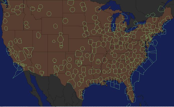
4 TRACONs 4

")
5 Arrival fixes Also called gates Metering points at which aircraft enter the TRACON Denver ARTCC (ZDV) Denver TRACON 5

6 TRACON ~ 4 miles 6
7 Terminology Airport with four well-defined (approximately equidistant) arrival fixes: Corner-post arrangement Arrangement of arrival fixes depends on the airport For example, Denver International Airport (DEN) and Atlanta Hartsfield-Jackson (ATL) have 4 arrival gates Boston Logan International Airport (BOS) has two arrival positions and one final control position Enroute Arrival control (TRACON) Final control (TRACON) Final control positions handle merging and spacing, using the downwind and base legs Timing (for spacing) achieved by altering length of trajectory è Trombone approaches è Approach fans 7

8 ATL (corner-post example) 8

9 Airport Arrival Demand Chart (AADC) [
10 Schematic of terminal-area arrivals Sequencing areas Downwind leg Final approach Base leg Base leg Downwind leg Sequencing areas 1


11 Example terminal-area trajectories: Antalya Airport (AYT)" Arrivals Departures miles km

12 Path stretching for spacing 12
13 Procedures: STARs Standard Terminal Arrival Routes Describe common arrival procedure Via the Pechy Three Arrival 13
14 354º º ' 174º 174º 174º AIP TURKEY STANDARD ARRIVAL CHART INSTRUMENT (STAR) - ICAO DHMI - ANKARA TRANSITION ALTITUDE 1 FT AIRAC AMDT 1/1 ' 352 º ACC : APP : TWR : AD 2 LTBA STAR OCT 1 ÝSTANBUL / ATATÜRK INTERNATIONAL RWY 17L/R Procedures: IST STARs CHANGE: RWY ID º ' 28º ' 41º ' 4º ' L/UL 66 G/UG 8 G/UG 12 M/UM 63 VOR EKI CH 11 X 4º57'3"N - º25'34"E W/UW 2 N/UN 64 G/UG 8 ULMAR N TEKIRDAG LT - P2 (IAF RWY 17) VURAL 8DME 3º N/UN 6 G/UG 8 282º 6 12º ' N/UN 6 G/UG 8 3º º 8' ' 21º º 174º IST R- 354 HOLDING OVER VURAL 3 FT 354 º 6 ULMAR 1B 33 ' EKI R- 83 CORLU NDB 426 CRL 41º7'54"N - º54'37 E BIG R- 47 BIGA VOR 116. BIG CH 116 X 4º17'3"N - º21'55 E CRL R- 3 CORLU CORLU VOR CRL CH 5 X BIG R- 55 BRG and TRACKS are MAG ELEV, ALT and HGT in FEET MSL DIST in NM VAR 4º ' E ( 24 ) ISTANBUL 41º'8"N - º56' E ' 6 BIG 1C 68 6 EKI 1C 5 ' 6 BIG 1F 55 LT - R 3 ÇORLU CTR 4 FT AMSL SFC CRL R- 7 ' (IAF RWY ) CEKMECE NDB 328 CEK 41º'21"N - 28º31'41 E 47º BANDIRMA LT - D 4 LT - D 5 NDB 36 IS 41º3'26"N - 28º48'23 E ' 6 ULMAR 1B 4 83º 55º HEZARFEN CTR 15 FT AMSL SFC º 5' º IST R- 235 ÝMREN FL 165 ISTANBUL TMA 15 FT AMSL LT - P7 1 EKÝ R- 6 HEZARFEN 5' BIG 1F LT - R 4 ÝSTANBUL VOR IST CH 72 X 4º57'45"N - 28º48'35 E UNSAV 2º ' 41º28 42 N- 28º47 23 E IST R- 354/ 31 FATIH 6 YASEN-GAYEM 1F YAA 1R 16 YEÞÝLKÖY CTR ATATÜRK 15 FT AMSL SFC 28º ' 2º ' 7º 3º º 5' - 5' EKI-BIG 1C 15 55º 5' BIG 1F 16 5' UNSAV 1 G IST R- 354 ' R- 287 NOTE: AVAILABILITY OF BIG- 1F SUBJECT TO PRIOR COORDINATION BTN IST ATC AND BANDIRMA MILITARY ATC IF MILITARY ACTIVITES NOT PERMIT FOR BIG 1 F BURSA IST ATC TO USE BIG- 1C ONLY SPEED CONTROL 23 YALOVA VOR YAA CH 124 X 4º28'3"N - 2º12' E 1) GENERAL RULE: MAX IAS 25 KT AT OR BELOW 1' WITHIN TMA 2) ARRIVING AIRCRAFT: - MAX IAS 25 KT AT 4 NM FROM IST VORTAC - MAX IAS 21 KT AT 15 NM FROM IST VORTAC - MAX IAS 16 KT UNTIL 5 NM FROM TRESHOLD - SPEED ACCURACY SHALL BE WITHIN 1 KT 54º YAA 1T-YAA1R 3 352º 4' 234º BKZ R-1726 (IAF RWY 17) BEYKOZ VOR BKZ CH 12 X YASEN 41º11'56"N- 2º3'58 E BKZ R-7 1/ D R-71 BKZ R-8 YAA R- 352 YENISEHIR VOR BRY NDB 352 BRY CH 1 X 4º15'48"N - 2º35'4 E 41º7'37"N - 2º8'34 E ' 7 YASEN 1F 17 7 GAYEM 1F 23 SABIHA GOKCEN ' 251º SABIHA GOKCEN CTR 25 FT AMSL SFC YENISEHIR CTR 8 FT AMSL SFC NOT TO SCALE 352º 6' 172º 8º L/UL 61 W/UW 72 GAYEM 41º2'45"N- 2º37'48 E BKZ R- 8/ D23 SABIHA GOKCEN VOR 18.8 SBH NDB 347 SAB CH 25 X 4º53'58"N - 2º1'13 E YALOVA YENISEHIR LT - D 1 36º º 3' 35' º º 3' 5' MSA 25 NM IST VORTAC LT - P5 L/UL 61 L/UL 62 A/UA 16 L/UL 615 A/UA 4 41º ' L/UL 614 G/UG 8 4º ' 14
15 Standard Instrument Departures (SIDs) 15
16 AIP TURKEY STANDARD DEPARTURE CHART INSTRUMENT (SID) - ICAO DHMI - ANKARA TRANSITION ALTITUDE 1 FT TWR : APP : ACC : AD 2 LTBA SID OCT 1 ÝSTANBUL / ATATÜRK INTERNATIONAL RWY 17L/R AIRAC AMDT 1/1 IST SIDs CHANGE: RWY ID º ' 28º ' BRG and TRACKS are MAG ELEV, ALT and HGT in FEET MSL DIST in NM VAR 4º ' E ( 24 ) CORLU 41º ' L/UL 66 G/UG 8 N G/UG 12 M/UM 63 TEKIRDAG VOR EKI CH 11 X 4º57'3"N - º25'34"E LT - P2 CORLU NDB 426 CRL CORLU CTR 4 FT AMSL 41º7'54"N - º54'37 E SFC N/UN 6 G/UG 8 VOR CRL CH 5 X 41º'8"N - º56' E CORLU BIG 2S L/UL 61 A/UA 16 FENER 41º17'11"N- 28º21'28"E IST R-3/ D28 CRL R- 11 EKI 2S CRL 2 S BIG 2S CEKMECE NDB 328 CEK FENER 2S IST R- 267 IST R º'21"N - 28º31'41 E FL 165 ISTANBUL TMA 15 FT AMSL LT - D 5 HEZARFEN CTR 15 AMSL SFC HEZARFEN 333º LT - P7 LT - R 4 2º ' ERTAS 41º'41"N - 2º8'48 E BKZ R-356/ D2 ÝSTANBUL VOR IST CH 72 X 42º 4º57'45"N - 28º48'35 E YEÞÝLKÖY CTR 15 FT AMSL SFC ATATÜRK IST R- 177 ERTAS 1S 5 DME YAA 2S BKZ R- 27 ERTAS 1T BKZ R- 172 BKZ R- 356 YAA R- 32 YAA R- 352 BEYKOZ VOR BKZ CH 12 X 41º7'37"N - 2º8'34 E YASEN 41º11'56"N- 2º3'58 E BKZ R-7 1/ D BKZ R- 71 YASEN 1S BKZ R- 8 GAYEM 1S YALOVA L/UL 61 W/UW 72 GAYEM 41º2'45"N- 2º37'48"E BKZ R- 8/ D23 SABIHA GOKCEN VOR 18.8 SBH NDB 347 SAB CH 25 X 4º53'58"N - 2º1'13 E LT - D 1 36º º 3' 35' º º 3' 5' MSA 25 NM IST VORTAC LT - P5 L/UL 615 A/UA 4 41º ' L/UL 614 G/UG 8 4º ' W/UW 2 N/UN 64 G/UG 8 N/UN 6 G/UG 8 BIG R- 38 BIGA VOR 116. BIG CH 116 X 4º17'3"N - º21'55 E BANDIRMA LT - R 3 LT - D 4 YALOVA VOR YAA NDB CH35 124YAA X CH 124 X 4º33'54"N 4º28'3"N - 2º22'17 E 2º12' E 28º ' 2º ' BURSA YENISEHIR CTR 8 FT AMSL SFC YENISEHIR VOR BRY NDB 352 BRY CH 1 X 4º15'48"N - 2º35'4 E NOT TO SCALE YENISEHIR L/UL 61 L/UL 62 A/UA 16 4º ' 16
17 Navigation (Precision approaches) Instrument Landing Systems (ILS) Localizer: Transmitter that defines a plane that extends vertically up from the runway centerline and its extension Glide slope: Ramp inclined at IAF to horizontal plane FAF 12ft 2ft Outer marker Middle marker 17
18 ILS categories ILS Decision ht. Visibility/Runway Visual Range (RVR) Category I 2ft 1/2 mile or RVR=ft Category II 1ft RVR=12ft Category IIIA RVR=7ft Category IIIB RVR=15ft Category IIIC RVR=
19 Instrument approaches Runway RT Missed Approach Point (MAP) Decision height TRACON Tower FAF/OM Elevation view ILS capture Cleared altitude before ILS capture Tower TRACON Missed approach (Straight out) RT FAF/OM ILS capture Base leg Final approach Plan view 1

20 Example: Go-around 2


21 Boston ILS approaches 15R ILS to visual 4L 21
22 Holding patterns Fix end Holding side Outbound Outbound end Fix Inbound Non-holding side Holding course Holding instructions need to include: direction of holding from fix; name of holding fix; radial, course, bearing, azimuth, route on which aircraft is to hold; direction of turns if not standard (standard = right-hand); Length if nonstandard (1 min inbound leg length); expected further clearance time 22

23 Airport and surrounding terminal area [Idris et al. 2, Carr 24] 23
24 Terminal-area separation: Wake vortex separation Aircraft are trailed by their wake vortices Each wing produces a vortex (that is, there are two counter-rotating vortices behind each aircraft) Strength of the vortex is a function of aircraft weight, speed and shape of the wing of the leading aircraft Maximum vortex generation occurs when aircraft is heavy and slow Therefore takeoffs and landings are particularly susceptible Small aircraft encountering the wake of a heavy aircraft may become uncontrollable Wake vortex separation is a fundamental bottleneck to airport and terminal-area capacity 24


25 Wake-vortex separation" [ 25

26 Multi-airport terminal-areas or Metroplexes [Bonnefoy & Hansman] 26

27 New York metroplex trajectories [Figure courtesy of Leo Prusak, Manager NorthEast Tactical Operations, FAA]
Terminal- Area Opera.ons Prof. Hamsa Balakrishnan
 Terminal- Area Opera.ons Prof. Hamsa Balakrishnan Istanbul Technical University Air Transporta,on Management M.Sc. Program Air Transporta,on Systems and Infrastructure Strategic Planning Module 8 : 26
CE 563 Airport Design
 CE 563 Airport Design Prevent aircraft collisions Prevent aircraft collisions with obstructions Expedite and maintain an orderly flow of air traffic Air traffic control system command center Herndon, VA
LOCALIZER I-SAM CH 28 VOR/DME SAC CH 98. CAUTION : ft Obstacle located R 245/12DME from VOR/DME. D2 (MAPt) GAFOA I-SAM (SDF) I-SAM
 GAFOA I-SAM (SDF) I-SAM") INSTRUMENT APPROACH CHART AERODROME ELEV 25 ft HEIGHTS RELATED TO HIGHTEST ELEV TDZ 17 ft HEON APP 135.4 344.7 HEON TWR 118.675 236.6 305.4 RKPS AD CHART 2-7 HEON/Sacheon (RKPS) LOC/DME RWY 06L ELEV, ALT
INSTRUMENT APPROACH CHART AERODROME ELEV 25 ft HEIGHTS RELATED TO HIGHTEST ELEV TDZ 17 ft HEON APP 135.4 344.7 HEON TWR 118.675 236.6 305.4 RKPS AD CHART 2-7 HEON/Sacheon (RKPS) LOC/DME RWY 06L ELEV, ALT
The aim of any instrument approach is to allow the aircraft to safely descend to a low altitude in order to become visual.
 INSTRUMENT APPROACH CHARTS "An instrument approach is just a series of straight lines joined by rate one turns" Ron Magrath The aim of any instrument approach is to allow the aircraft to safely descend
PBN AIRSPACE CONCEPT WORKSHOP. SIDs/STARs/HOLDS. Continuous Descent Operations (CDO) ICAO Doc 9931
 ICAO Doc 9931") International Civil Aviation Organization PBN AIRSPACE CONCEPT WORKSHOP SIDs/STARs/HOLDS Continuous Descent Operations (CDO) ICAO Doc 9931 Design in context Methodology STEPS TFC Where does the traffic
International Civil Aviation Organization PBN AIRSPACE CONCEPT WORKSHOP SIDs/STARs/HOLDS Continuous Descent Operations (CDO) ICAO Doc 9931 Design in context Methodology STEPS TFC Where does the traffic
Design Airspace (Routes, Approaches and Holds) Module 11 Activity 7. European Airspace Concept Workshops for PBN Implementation
 Module 11 Activity 7. European Airspace Concept Workshops for PBN Implementation") Design Airspace (Routes, Approaches and Holds) Module 11 Activity 7 European Airspace Concept Workshops for PBN Implementation Design in Context TFC Where does the traffic come from? And when? RWY Which
Design Airspace (Routes, Approaches and Holds) Module 11 Activity 7 European Airspace Concept Workshops for PBN Implementation Design in Context TFC Where does the traffic come from? And when? RWY Which
Honeywell.com PBN Concepts Krakow, Poland
 PBN Concepts Krakow, Poland EPKK (KRK) Current Operational Environment Current Operational Environment : Runways: 07/25 8,366 ft (2550m) Approaches: ILS or LOC 25 RNAV (GNSS) 07, 25 VOR 07, 25 NDB 25 Departure
Standard Operating Procedures (SOPs) for BAGHDAD (ORBI)
 for BAGHDAD (ORBI)") Pag.1 of 11 Standard Operating Procedures (SOPs) for BAGHDAD (ORBI) Index 1. FOREWORD... 3 2. ATC UNITS... 3 3. RECOMMENDATIONS... 3 3.1. TRANSITION ALTITUDE/LEVEL... 3 3.2. SEMI-CIRCULAR FLIGHT LEVEL
Pag.1 of 11 Standard Operating Procedures (SOPs) for BAGHDAD (ORBI) Index 1. FOREWORD... 3 2. ATC UNITS... 3 3. RECOMMENDATIONS... 3 3.1. TRANSITION ALTITUDE/LEVEL... 3 3.2. SEMI-CIRCULAR FLIGHT LEVEL
AIP ENR JORDAN 01 MAY 2014
 AIP ENR 1.5-1 JORDAN 01 MAY 2014 ENR 1.5 HOLDING, APPROACH AND DEPARTURE PROCEDURES 1. GENERAL 1.1 The procedures used in Jordan are generally in accordance with ICAO DOC 8168. Holding patterns in Jordan
Standard Operational Procedures
 Standard Operational Procedures Aerodrome Ostrava Mošnov VERSION 1.2 CHANGES AND UPDATES Effective Version Change 24 JUN 09 1.1 LVP added. 12 FEB 11 1.2 General text revision. NOTES Official scenery and
AD 2. AERODROMES FYWE AD 2.1 AERODROME LOCATION INDICATOR AND NAME. FYWE - Windhoek (Eros) Airport
 Airport") AIP FYWE AD 2-1 Republic of Namibia 20 JUL 2017 AD 2. AERODROMES FYWE AD 2.1 AERODROME LOCATION INDICATOR AND NAME FYWE - Windhoek (Eros) Airport FYWE AD 2.2 AERODROME GEOGRAPHICAL AND ADMINISTRATIVE DATA
AIP FYWE AD 2-1 Republic of Namibia 20 JUL 2017 AD 2. AERODROMES FYWE AD 2.1 AERODROME LOCATION INDICATOR AND NAME FYWE - Windhoek (Eros) Airport FYWE AD 2.2 AERODROME GEOGRAPHICAL AND ADMINISTRATIVE DATA
EKYT - AALBORG AIR BASE
 EKYT AD 2.1-1 EKYT - AALBORG AIR BASE 1. AERODROME LOCATION INDICATOR AND NAME EKYT AIR TRANSPORT WING AALBORG 2. AERODROME GEOGRAPHICAL AND ADMINISTRATIVE DATA 1 ARP coordinates and site at AD 570534.04N
AD 2. AERODROMES VAKS AD 2.2 AERODROME GEOGRAPHICAL AND ADMINISTRATIVE DATA
 AD 2-1 AD 2. AERODROMES AD 2.1 AERODROME LOCATION INDICATOR AND NAME - KESHOD / DOMESTIC AD 2.2 AERODROME GEOGRAPHICAL AND ADMINISTRATIVE DATA 1 Aerodrome reference point coordinates and its site 2 Direction
Orientation Booklet The New Airline Chart Series
 Orientation Booklet The New Airline Chart Series Copyright 2007 Jeppesen. All rights reserved. Table of Contents Introduction...1 Approach Chart...2 Heading...2 Plan View...2 Profile View... Minimums...
LZMC/MLC MALACKY 01 JAN IEff 01 FebI. MALACKY, SLOVAKIA Additional Airport Informations. 1. Services ATC and Meteo services available H24.
 MALACKY 01 JAN 08 10 1 I Additional Airport Informations 1. Services ATC and Meteo services available H24. Telephone numbers: TWR: 00421 960 390 230 00421 960 390 231 METEO Office: 00421 960 390 240 00421
ZTL ARTCC. Asheville Regional. Air Traffic Control Tower. Standard Operating Procedures AVL B. Effective: May 1, 2011
 ZTL ARTCC Asheville Regional Air Traffic Control Tower Standard Operating Procedures AVL 7110.65B Effective: May 1, 2011 CHAPTER 1. GENERAL CONTROL SECTION 1. EQUIPMENT 1 1-1-1. Callsign Usage and Frequency
Chapter 6. Nonradar. Section 1. General DISTANCE
 12/10/15 JO 7110.65W Chapter 6. Nonradar Section 1. General 6 1 1. DISTANCE Use mileage based (DME and/or ATD) procedures and minima only when direct pilot/controller communications are maintained. FIG
Learning. Goals. Patterns HOW WHEN. Holding. at the. that case. Page 1 of 19. Document : V1.1
 Learning Goals Holding Patterns HOW TO STOP WHEN YOU ARE AIRBOURNE. Holding Patterns are very important. In this lesson we will learn why they are so important and how to execute them. Imagine you are
HOLDING PATTERN USING VOR
 HOLDING PATTERN USING VOR 1. Introduction This documentation will present an example of a holding pattern using a VOR as holding point. 2. First Step Before holding over a VOR, you must study the approach
AD 2 AERODROMES EVLA AD 2.1 AERODROME LOCATION INDICATOR AND NAME EVLA AD 2.2 AERODROME GEOGRAPHICAL AND ADMINISTRATIVE DATA
 18 NOV 2010 AIP LATVIA EVLA AD 2-1 18 NOV 2010 AD 2 AERODROMES Note: The following sections in this chapter are intentionally left blank: AD-2.16, AD-2.23 EVLA AD 2.1 AERODROME LOCATION INDICATOR AND NAME
Don-Jacques OULD FERHAT VP Airspace and Airlines Services. Airbus. PBN Safety programs
 Don-Jacques OULD FERHAT VP Airspace and Airlines Services Airbus PBN Safety programs Long term cooperation with China Complex projects in China RNP AR at Kathmandu airport Cochin : First RNP APCH in India
Airservices Australia 2016
 Airservices Australia 2016 Airservices Australia 2016 Airservices Australia 2015 Airservices Australia 2016 Airservices Australia 2016 ATIS (H24) (TWR HR) APP TWR SMC ACD FIA (AH) GOLD COAST, QLD (YBCG)
 IFR 91.157 Must be instrument rated to fly special VFR at Night (civil twilight to civil twilight, sun 6 degrees below horizon) 91.159 Unless in a holding pattern of 2 minutes or less, VFR cruising altitude
IVAO Nordic Region November 2018 PILOT BRIEFING ROVANIEMI X-MAS FLY-IN
 PILOT BRIEFING ROVANIEMI X-MAS FLY-IN GENERAL ICAO: EFRO IATA: RVN Runways: 03/21 AIP SUPPLEMENT An AIP Supplement will be in effect on the day of the event. This supplement details vital procedures for
EVVA AD 2.1 AERODROME LOCATION INDICATOR AND NAME EVVA AD 2.2 AERODROME GEOGRAPHICAL AND ADMINISTRATIVE DATA
 18 NOV 2010 AIP LATVIA EVVA AD 2-1 18 NOV 2010 Note: The following sections in this chapter are intentionally left blank: AD-2.16, AD-2.23 EVVA AD 2.1 AERODROME LOCATION INDICATOR AND NAME EVVA - VENTSPILS
Gleim Instrument Pilot FAA Knowledge Test 2012 Edition, 1st Printing Updates January 27, 2012
 Page 1 of 5 Gleim Instrument Pilot FAA Knowledge Test 2012 Edition, 1st Printing Updates January 27, 2012 NOTE: Text that should be deleted from the question is displayed with a line through the text.
AREA NAVIGATION RNAV- MANAGEMENT
 1. Introduction AREA NAVIGATION RNAV- MANAGEMENT RNAV is an instrument-based navigation method that leads to fly from a fix (geographic point inside an airspace) to another fix directly. Contrary to conventional
APPENDIX C AIRSPACE PROCEDURES
 APPENDIX C AIRSPACE PROCEDURES This appendix is designed to provide the reader with an introduction to how aircraft operate in and around Cincinnati/Northern Kentucky International Airport (CVG), the facilities
Denver ARTCC Colorado Springs ATCT & TRACON STANDARD OPERATING PROCEDURES
 Denver ARTCC Colorado Springs ATCT & TRACON STANDARD OPERATING PROCEDURES OCTOBER 7, 2018 Definition of Airspace Colorado Springs Class C airspace is defined as show in Appendix 1. Definition of Positions
EVTA AD 2.1 AERODROME LOCATION INDICATOR AND NAME EVTA AD 2.2 AERODROME GEOGRAPHICAL AND ADMINISTRATIVE DATA
 18 NOV 2010 AIP LATVIA EVTA AD 2-1 18 NOV 2010 Note: The following sections in this chapter are intentionally left blank: AD-2.11, AD-2.14, AD-2.15, AD-2.16, AD- 2.19, AD-2.20, AD-2.21, AD-2.23 EVTA AD
SECTION 4 - APPROACH CONTROL PROCEDURES
 SECTION 4 - APPROACH CONTROL PROCEDURES CHAPTER 1 - PROVISION OF SERVICES 1.1 An approach control unit shall provide:- a) Approach control service. b) Flight Information service. c) Alerting service. RESPONSIBILITIES
S2 Tower Controller. Allama Iqbal Int l Airport Lahore ( OPLA ) June 2016 Pakistan vacc
 June 2016 Pakistan vacc") S2 Tower Controller Allama Iqbal Int l Airport Lahore ( OPLA ) June 2016 Pakistan vacc Introduction: The next stage in your controlling at Lahore as a tower controller is S2 rating. To be an S2 Controller
S2 Tower Controller Allama Iqbal Int l Airport Lahore ( OPLA ) June 2016 Pakistan vacc Introduction: The next stage in your controlling at Lahore as a tower controller is S2 rating. To be an S2 Controller
Continuous Descent? And RNAV Arrivals
 Continuous Descent? And RNAV Arrivals From an ATC Perspective Presentation to: CDA Workshop GA Tech Name: Don Porter RNP Project Lead FAA, RNAV RNP Group Date: 18 April 2006 My Background 22 years Terminal
OMURA AERODROME A-3 ABN A-2 APRON. MEHT 13.6m(44.6ft) PAPI Angle 3.0. MEHT 13.6m(44.6ft) PAPI Angle 3.0. is not visible from NAGASAKI Tower.
 PAPI Angle 3.0. MEHT 13.6m(44.6ft) PAPI Angle 3.0. is not visible from NAGASAKI Tower.") AIP Japan RJDU-AD2-24.1 RJDU / AD CHART AERODROME ABN TRUE NORTH 18 2 2 1 3 A-2 2 2 A-1 APRON 1 3 WDI PAPI Angle 3.0 MEHT 13.6m(44.6ft) PAPI Angle 3.0 MEHT 13.6m(44.6ft) 0 100 200 300m A-3 TO TWR 3 1 36
AIP Japan RJDU-AD2-24.1 RJDU / AD CHART AERODROME ABN TRUE NORTH 18 2 2 1 3 A-2 2 2 A-1 APRON 1 3 WDI PAPI Angle 3.0 MEHT 13.6m(44.6ft) PAPI Angle 3.0 MEHT 13.6m(44.6ft) 0 100 200 300m A-3 TO TWR 3 1 36
CHAPTER 5 SEPARATION METHODS AND MINIMA
 CHAPTER 5 SEPARATION METHODS AND MINIMA 5.1 Provision for the separation of controlled traffic 5.1.1 Vertical or horizontal separation shall be provided: a) between IFR flights in Class D and E airspaces
RWY 24. Designator Route Remarks. All traffic shall initially climb to 4000FT QNH with climb gradient 3.3% MNM, unless instructed otherwise by ATC.
 AD 2.ELLX-15 DISKI 2Y GTQ 7X GTQ 7Y MMD 7X RAPOR 4X 3.2.2 Climb Requirements RWY 24 Designator Route Remarks R-238 LUX to 8 DME LUX, RT to intercept R-222 NTM to 24 DME NTM, RT R-156 DIK, LT R-115 LUX
AIP Georgia AD 2.UGTB-RSID-13R 18/09/2014 STANDARD DEPARTURE ROUTES INSTRUMENT (SID) RWY 13R SID ROUTING AND ALTITUDES MIN. CLIMB GRAD. LAMUS 6A LAMUS
 RWY 13R SID ROUTING AND ALTITUDES MIN. CLIMB GRAD. LAMUS 6A LAMUS") AIP Georgia AD 2.UGTB-RSID-13R 18/09/2014 STANDARD DEPARTURE ROUTES INSTRUMENT (SID) RWY 13R SID ROUTING AND ALTITUDES MIN. CLIMB GRAD. LAMUS 6A LAMUS 4A LAGAS 2A DF 6A DF 4A LAMUS SIX ALFA After take
AIP Georgia AD 2.UGTB-RSID-13R 18/09/2014 STANDARD DEPARTURE ROUTES INSTRUMENT (SID) RWY 13R SID ROUTING AND ALTITUDES MIN. CLIMB GRAD. LAMUS 6A LAMUS 4A LAGAS 2A DF 6A DF 4A LAMUS SIX ALFA After take
MHTG (Toncontin Intl)
") Airport Information MHTG (Toncontin Intl) General Info Tegucigalpa, HN N 14 03.6' W 87 13.0' Mag Var: 1.6 E Elevation: 3297' Public, IFR, Control Tower, Rotating Beacon, Customs, Landing Fee Fuel: 100LL,
Airport Information MHTG (Toncontin Intl) General Info Tegucigalpa, HN N 14 03.6' W 87 13.0' Mag Var: 1.6 E Elevation: 3297' Public, IFR, Control Tower, Rotating Beacon, Customs, Landing Fee Fuel: 100LL,
Standard Operating Procedures (SOPs) for UAE Centre (OMAE)
 for UAE Centre (OMAE)") Standard Operation Procedures for UAE Centre (OMAE) Pag.1 of 10 Standard Operating Procedures (SOPs) for UAE Centre (OMAE) Standard Operation Procedures for UAE Centre (OMAE) Pag.2 of 10 Index 1. Foreword...
Standard Operation Procedures for UAE Centre (OMAE) Pag.1 of 10 Standard Operating Procedures (SOPs) for UAE Centre (OMAE) Standard Operation Procedures for UAE Centre (OMAE) Pag.2 of 10 Index 1. Foreword...
PORTUGAL DIRECÇÃO DE SEGURANÇA E DESEMPENHO OPERACIONAL AERONAUTICAL INFORMATION SERVICE APARTADO LISBOA CODEX
 PORTUGAL PHONE: +351.21.8553506 FAX: +351.21.8553399 E-Mail: desica@nav.pt AFTN: LPPPYOYC DIRECÇÃO DE SEGURANÇA E DESEMPENHO OPERACIONAL AERONAUTICAL INFORMATION SERVICE APARTADO 8223 1803-001 LISBOA CODEX
SkyHoppers Aerial Adventures Instrument Ground School Mid-Term Exam A. R. Dilworth, CFII Flight Instruments
 SkyHoppers Aerial Adventures Instrument Ground School Mid-Term Exam A. R. Dilworth, CFII Flight Instruments 365.H808 Altimeter setting is the value to which the scale of the pressure altimeter is set so
Jeppesen NavData and Charts
 May 2001 The Harmonization of Information for Pilots on Charts and Avionics By James E. Terpstra Senior Corporate Vice President Flight Information and Technology and Aviation Affairs Jeppesen This paper
RNAV - RNP. July 2010
 RNAV - RNP July 2010 July 2010 Issue 1 Page 1 of 6 1 Who Issues approval to fly in P-RNAV Airspace? a) National Authority b) Euro Control c) JAA d) ICAO 2 A Fixed Published Route is? a) Alternative / Reserve
JeppView for Windows. General Information. jep=jeppesen. Runway: 17R. Length x Width: 9843 ft x 148 ft. Location: ISTANBUL TUR. Surface Type: concrete
 Airport Information For LTBA Printed on 11 ec 2017 Page 1 (c) JEPPESEN SANERSON, INC., 2017, ALL RIGHTS RESERVE jep=jeppesen JeppView for Windows General Information Runway: 17R Length x Width: 9843 ft
AIP AD SEYCHELLES 03 APR 14
 AIP AD 0.6-1 SEYCHELLES 03 APR 14 AD PART 3 AERODROMES (AD) AD 0.6 TABLE OF CONTENTS TO PART 3 AD 1. AERODROMES/HELCOPTER LANDING AREAS INTRODUCTION Pages AD 1.1 Aerodrome/helicopter landing areas availability
HOLDING STACK MANAGEMENT
 1. Introduction HOLDING STACK MANAGEMENT When an air traffic controller has such an amount of traffic in his approach area that he cannot handle more traffic for a determined or non-determined period of
WITH FLY. Goals. Learning. For this. Terminal Arrival) to charts. correct SID STARS AIRPORT APROACH ENROUTE CHARTS. is and. turn left AMS VOR VOLLA.
 to charts. correct SID STARS AIRPORT APROACH ENROUTE CHARTS. is and. turn left AMS VOR VOLLA.") Learning Goals Reading Charts FLY WITH THE CORRECT CHARTS The use of proper and correct charts is essential in the flying world. For this you would need the most up to date charts available, so that you
Learning Goals Reading Charts FLY WITH THE CORRECT CHARTS The use of proper and correct charts is essential in the flying world. For this you would need the most up to date charts available, so that you
Feasibility and Benefits of a Cockpit Traffic Display-Based Separation Procedure for Single Runway Arrivals and Departures
 Feasibility and Benefits of a Cockpit Traffic Display-Based Separation Procedure for Single Runway Arrivals and Departures Implications of a Pilot Survey and Laboratory Simulations Dr. Anand M. Mundra
Piedmont Triad International Airport
 ZTL ARTCC Piedmont Triad International Airport Airport Traffic Control Tower Standard Operating Procedures GSO 7110.65B Effective: May 1, 2011 1 CHAPTER 1. GENERAL CONTROL SECTION 1. EQUIPMENT 1-1-1. Callsign
AD 2-OERY-1 7 JAN 16 OERY AD 2.1 AERODROME LOCATION INDICATOR AND NAME. OERY - RIYADH/ King Salman Air Base
 AD 2-OERY-1 OERY AD 2.1 AERODROME LOCATION INDICATOR AND NAME OERY - RIYADH/ King Salman Air Base OERY AD 2.2 AERODROME GEOGRAPHICAL AND ADMINISTRATIVE DATA 1 ARP coordinates and site at AD 244319N 0464329E/
Effective: GOLD COAST (YBCG) NEW PROCEDURES FOR INTRODUCTION OF ILS ON RWY 14
 NEW PROCEDURES FOR INTRODUCTION OF ILS ON RWY 14") AUSTRALIA AERONAUTICAL INFORMATION SERVICE AIRSERVICES AUSTRALIA GPO BOX 367, CANBERRA ACT 2601 Phone: 02 6268 4874 Email: aim.editorial@australia.com Effective: AIP SUPPLEMENT (SUP) AIRAC H 04/19 201902271600
AUSTRALIA AERONAUTICAL INFORMATION SERVICE AIRSERVICES AUSTRALIA GPO BOX 367, CANBERRA ACT 2601 Phone: 02 6268 4874 Email: aim.editorial@australia.com Effective: AIP SUPPLEMENT (SUP) AIRAC H 04/19 201902271600
MetroAir Virtual Airlines
 MetroAir Virtual Airlines NAVIGATION BASICS V 1.0 NOT FOR REAL WORLD AVIATION GETTING STARTED 2 P a g e Having a good understanding of navigation is critical when you fly online the VATSIM network. ATC
AIP MACAO GUANG ZHOU FIR HONG KONG FIR AD2-VMMC-65 A STAR MACAO RWY SEP 2013 (BIGRO 6 A, NLG 5 A, CON 6 A, POU 6 A) CAT A, B, C, D
 CAT A, B, C, D") AIP MACAO GUANG ZHOU FIR HONG KONG FIR AD2-VMMC-65 A STAR MACAO RWY 34 19 SEP 2013 (BIGRO 6 A, NLG 5 A, CON 6 A, POU 6 A) CAT A, B, C, D BIGRO 6 A Proceed from BIGRO to UJ. Cross GURIN at 2700 m and cross
AIP MACAO GUANG ZHOU FIR HONG KONG FIR AD2-VMMC-65 A STAR MACAO RWY 34 19 SEP 2013 (BIGRO 6 A, NLG 5 A, CON 6 A, POU 6 A) CAT A, B, C, D BIGRO 6 A Proceed from BIGRO to UJ. Cross GURIN at 2700 m and cross
EXPLANATION OF TPP TERMS AND SYMBOLS
 U.S. TERMINAL PROCEDURES PUBLICATION 52 EXPLANATION OF TPP TERMS AND SYMBOLS The discussions and examples in this section will be based primarily on the IFR (Instrument Flight Rule) Terminal Procedures
Controller Training Case Study Implementation of new RNP AR APCH for RWY07 (North Circuit) at HKIA
 at HKIA") Controller Training Case Study Implementation of new RNP AR APCH for RWY07 (North Circuit) at HKIA Disclaimer This presentation is for information purposes only. It should not be relied on as the sole
Controller Training Case Study Implementation of new RNP AR APCH for RWY07 (North Circuit) at HKIA Disclaimer This presentation is for information purposes only. It should not be relied on as the sole
UDSG Gyumri. UDSG AD 2.1 Aerodrome location indicator and name. UDSG AD 2.2 Aerodrome geographical and administrative data N E
 AIP Republic of Armenia AD 2.UDSG-1 ~~~eaip-amdt~~~airac-2016-0321 JUL 2016 UDSG Gyumri UDSG AD 2.1 Aerodrome location indicator and name UDSG Gyumri UDSG AD 2.2 Aerodrome geographical and administrative
AIP ENR JORDAN 12 DEC 2013 RADAR SERVICES AND PROCEDURES
 AIP ENR 1.6-1 JORDAN 12 DEC 2013 ENR 1.6 RADAR SERVICES AND PROCEDURES 1. GENERAL 1.1 SERVICES a) Radar units in the Amman FIR operate as integral parts of the ATS system and provide Radar Control Service
Standard Operational Procedures
 Standard Operational Procedures Aerodrome Praha Ruzyně VERSION 4.0 CHANGES AND UPDATES Effective Version Change - 3.8 Intentionally left blank. 09 JUN 11 3.9 General text revision. New design issued. 15
Providence ATCT Standard Operating Procedures
 This air traffic control procedural document is provided for virtual air traffic control in the ZBW ARTCC of the VATSIM network only. It is not for real-world ATC use. These procedures are approved for
Chapter 6. Airports Authority of India Manual of Air Traffic Services Part 1
 Chapter 6 6.1 ESSENTIAL LOCAL TRAFFIC 6.1.1 Information on essential local traffic known to the controller shall be transmitted without delay to departing and arriving aircraft concerned. Note 1. Essential
Instrument Proficiency Check Flight Record
 Instrument Proficiency Check Flight Record Date: Flight Time: Sim. Inst. Time: Pilot Name: Aircraft Type: Aircraft Tail Number: Act. Inst. Time: Instructor Name: Holding Procedures Task Notes N/A Satisfactory
DIRECCION DE PERSONAL AERONAUTICO DPTO. DE INSTRUCCION PREGUNTAS Y OPCIONES POR TEMA
 T E M : 0322 INSTRUTOR_DVNED_07_PROEDURES & IRPT OPS OD_PREG: P R E G U N T : RPT: 6436 n airport without a control tower lies within the controlled airspace of an airport with an operating tower. ccording
GENERAL INFORMATION The aerodrome consists of three runways (04L-22R, 04R-22L, 12-30) and four aprons.
 and four aprons.") GENERAL INFORMATION The aerodrome consists of three runways (04L-22R, 04R-22L, 12-30) and four aprons. The two parallel runways are about 3000 metres long while the intersecting runway (12-30) is about
GENERAL INFORMATION The aerodrome consists of three runways (04L-22R, 04R-22L, 12-30) and four aprons. The two parallel runways are about 3000 metres long while the intersecting runway (12-30) is about
List of pages in this Trip Kit
 Trip Kit Index Printed on 23 Feb 2013 Page 1 VALIO SOLO PARA SU USO EN SIMULAOR jep= FIR BOLIVIA List of pages in this Trip Kit Trip Kit Index Airport Information For SLTJ Terminal Charts For SLTJ Revision
SITE ELEVATION AMSL...Ground Elevation in feet AMSL STRUCTURE HEIGHT...Height Above Ground Level OVERALL HEIGHT AMSL...Total Overall Height AMSL
 ******************************************** * Federal Airways & Airspace * * Summary Report * ******************************************** File: User Assigned File Name Latitude: NAD83 Coordinate Longitude:
Eastern Caribbean PIARCO Virtual FIR. PIARCO Control Zone (CTR)
") PIARCO Control Zone (CTR) Eastern Caribbean PIARCO Virtual FIR NOT TO BE USED FOR REAL WORLD AVIATION, STRICTLY FOR USE ON THE VATSIM VIRTUAL ATC NETWORK. 1. Introduction 1.1 Objective of this SOP is to
PIARCO Control Zone (CTR) Eastern Caribbean PIARCO Virtual FIR NOT TO BE USED FOR REAL WORLD AVIATION, STRICTLY FOR USE ON THE VATSIM VIRTUAL ATC NETWORK. 1. Introduction 1.1 Objective of this SOP is to
Jordan Airspace Manual. Prepared by: Aboud Horani & Mahmoud Odeh XM-AOC / XM-ADIR
 Jordan Airspace Manual Prepared by: Aboud Horani & Mahmoud Odeh XM-AOC / XM-ADIR 1 Contents 1.0 Introduction:... 3 1.1 Airport Information:... 3 1.2 Adjoining FIRs:... 3 1.3 ATC Units:... 4 2.0 Procedures:...
Number April 2016
 Luxembourg Air Safety Bulletin Number 16-001 - April 2016 This Air Safety Bulletin examines a number of hazards related to flying in and out, and in the vicinity of, Luxembourg Airport. As the Direction
Airfield Capacity Prof. Amedeo Odoni
 Airfield Capacity Prof. Amedeo Odoni Istanbul Technical University Air Transportation Management M.Sc. Program Air Transportation Systems and Infrastructure Module 10 May 27, 2015 Airfield Capacity Objective:
Application of Wake Turbulence Separation at London Heathrow. Paul Johnson Development Manager NATS Heathrow
 Application of Wake Turbulence Separation at London Heathrow Paul Johnson Development Manager NATS Heathrow Heathrow Vital Statistics Passengers per year 67 Million Aircraft movements per year 470,000
APPENDIX B DRO INSTRUMENT APPROACH CHARTS & DEPARTURE PROCEDURES
 APPENDIX B INSRUMEN APPROACH CHARS & DEPARURE PROCEDURES DURANGO, COLORADO LOC I- Rwy Idg APP CRS DZE 09. Apt Elev 920 668 6685 AL-480 (FAA) ILS or LOC/DME RWY DURANGO-LA PLAA COUNY() DME from VOR/DME.
[1] Gleim #: Source: AIM Para Learning Statement Code: PLT141
![[1] Gleim #: Source: AIM Para Learning Statement Code: PLT141](/thumbs/75/71500728.jpg "[1] Gleim #: Source: AIM Para Learning Statement Code: PLT141") Gleim FAA Test Prep: Private Pilot (15 questions) Unit 3a: Airports, Air Traffic Control, and Airspace Name: Date: Circle the correct answer on the question sheets and fill in the corresponding circle
Gleim FAA Test Prep: Private Pilot (15 questions) Unit 3a: Airports, Air Traffic Control, and Airspace Name: Date: Circle the correct answer on the question sheets and fill in the corresponding circle
LGAV LTAI Real Flights Event Partnership EUROPE. PILOT's BRIEFING. March 7 th 2009 Event time: 1200z 2200z. 1 Athens FIR Guide 2 LGAV Procedures
 LGAV LTAI Real Flights Event Partnership EUROPE PILOT's BRIEFING March 7 th 2009 Event time: 1200z 2200z 1 Athens FIR Guide 2 LGAV Procedures Written by: Georgios Tzoumbas (GR-TC) & Babis Delagrammatikas
Navigation at the. Federal Aviation Administration Crossroads
 Navigation at the Crossroads To: Stanford 2010 PNT Symposium By: Leo Eldredge GNSS Program Manager Date: Peak Aircraft Traffic Over The US 5000 aircraft 689 M passengers 36 B pounds cargo 2 If We Do Nothing
MINIMUM FLIGHT ALTITUDES
 MINIMUM FLIGHT ALTITUDES 1. Introduction Minimum flight altitudes are created first to ensure safety, awareness and adequate radio navigation reception for aircraft flying at the same time in specific
LFMN / Nice Côte-d Azur / NCE
 This page is intended to draw commercial and private pilots attention to the aeronautical context and main threats related to an aerodrome. They have been identified in a collaborative way by the main
Albany ATCT Standard Operating Procedures
 Albany ATCT Standard Operating Procedures This air traffic control procedural document is provided for virtual air traffic control in the ZBW ARTCC of the VATSIM network only. It is not for real-world
Greenville Spartanburg International
 ZTL ARTCC Greenville Spartanburg International Airport Traffic Control Tower Standard Operating Procedures GSP 7110.65B Effective: May 1, 2011 1 CHAPTER 1. GENERAL CONTROL SECTION 1. EQUIPMENT 2-1-1. Callsign
SULAYMANIYAH INTERNATIONAL AIRPORT MATS CHAPTER 11
 KURDISTAN REGIONAL GOVERNMENT SULAYMANIYAH INTERNATIONAL AIRPORT MATS CHAPTER 11 SEPARATION STANDARDS & APPLICATIONS International and Local Procedures ( First Edition ) April 2012 Ff Prepared By Fakhir.F.
Cape Area Airports Standard Operating Procedures
 Cape Area Airports Standard Operating Procedures This air traffic control procedural document is provided for virtual air traffic control in the ZBW ARTCC of the VATSIM network only. It is not for real-world
AD 2-LGPL-1 GREECE 04 JAN 2018 LGPL AD 2.1 AERODROME LOCATION INDICATOR AND NAME LGPL ASTYPALAIA
 AIP AD 2-LGPL-1 GREECE 04 JAN 2018 LGPL AD 2.1 AERODROME LOCATION INDICATOR AND NAME LGPL ASTYPALAIA LGPL AD 2.2 AERODROME GEOGRAPHICAL AND ADMINISTRATIVE DATA 1 ARP coordinates and site at AD 363448N
Source: Chippewa Valley Regional Airport ASOS, Period of Record
 Chapter 1 Inventory Runway wind coverage is the percentage of time a runway can be used without exceeding allowable crosswind velocities. Allowable crosswind velocities vary depending on aircraft size
Single Engine Instrument Training Record I PREFLIGHT PREPARATION WEATHER INFORMATION weather reports and forecasts. pilot and radar reports.
 Single Engine Instrument Training Record I PREFLIGHT PREPARATION WEATHER INFORMATION weather reports and forecasts. pilot and radar reports. surface analysis charts. radar summary charts. significant weather
ILS APPROACH WITH B737/A320
 ILS APPROACH WITH B737/A320 1. Introduction This documentation will present an example of Instrument landing system (ILS) approach performed with Boeing 737. This documentation will give some tips also
AIRSPACE STRUCTURE. In aeronautics, airspaces are the portion of the atmosphere controlled by a country above its territory.
 AIRSPACE STRUCTURE 1. Introduction In aeronautics, s are the portion of the atmosphere controlled by a country above its territory. There are two kinds of : Controlled is of defined dimensions within which
Federal Aviation Administration. Air Traffic 101. By: Michael Valencia & Dianna Johnston Date: Feb. 26, 2017
 Presented to: UC Davis Aviation Symposium By: Michael Valencia & Dianna Johnston Date: Overview Part 1 Air Traffic Controllers History Safety and Navigation Terminology Air Traffic Facility Types Equipment
Airport Information. Details for OMIROS. State/Province
 Airport Information etails for OMIROS City State/Province Country GRC Latitude N 38 20' 36.00" Longitude E 26 0 26.00" Elevation 5 Longest Runway 4900 Magnetic Variance E 4.0 Fuel Type JET A- fuel is available
USE OF RADAR IN THE APPROACH CONTROL SERVICE
 USE OF RADAR IN THE APPROACH CONTROL SERVICE 1. Introduction The indications presented on the ATS surveillance system named radar may be used to perform the aerodrome, approach and en-route control service:
GEN 0.2 Record of AIP Amendments
 AIP Georgia GEN 0.- ~~~eaip-amdt~~~airac0000/0/00 GEN 0. Record of AIP Amendments 0/007 0/007 0/007 0/007 0/008 0/008 0/008 0/008 0/009 0/009 0/009 0/009 0/00 0/00 NR/Year AIRAC AIP AMENDMENT Publication
IFR SEPARATION WITHOUT RADAR
 1. Introduction IFR SEPARATION WITHOUT RADAR When flying IFR inside controlled airspace, air traffic controllers either providing a service to an aircraft under their control or to another controller s
SIMULATION USE ONLY. DO NOT USE FOR REAL WORLD NAVIGATION N IVAO HONG KONG
 53 52 51 50 H1 E1 60 MAINTENANCE APRON E 59 E1 61 F 58 EAST APRON 49 48 H1 G 57 55 56 H1 54 H 47 46 45 44 43 41 CARGO APRON SIMULATION USE ONLY. DO NOT USE FOR REAL WORLD NAVIGATION. 22 19 02 N AERODROME
PLAN Anoka County - Blaine Airport
 Reliever Airports: NOISE ABATEMENT PLAN Anoka County - Blaine Airport INTRODUCTION The noise abatement plan for the Anoka County-Blaine Airport was prepared in recognition of the need to make the airport
Air Navigation Bureau ICAO Headquarters, Montreal
 Performance Based Navigation Introduction to PBN Air Navigation Bureau ICAO Headquarters, Montreal 1 Performance Based Navigation Aviation Challenges Navigation in Context Transition to PBN Implementation
Annecy Airport IFR briefing For indication only
 1 DISCLAIMER The pieces of information provided are published only for indication, and are not exhaustive. We make our best effort to keep them updated. They are a valuable complement for flight preparation
JeppView for Windows. List of pages in this Trip Kit. jep=jeppesen. Trip Kit Index
 Trip Kit Index Printed on 8 Jun 015 Page 1 (c) JEPPESEN SANERSON, IN., 015, ALL RIGHTS RESERVE List of pages in this Trip Kit Trip Kit Index Airport Information For TLP Terminal harts For TLP Revision
GEORGIA. Georgian Air Navigation Sakaeronavigatsia Ltd. AERONAUTICAL INFORMATION SERVICE. TBILISI/Tbilisi Airport, 0158 Tbilisi, Georgia
 TEL: FAX: AFTN: E-mail: (+995 32) 274 42 95 (+995 32) 274 42 37 (+995 32) 274 42 23 UGTBYOYX ais@airnav.ge ais@caucasus.net GEORGIA Georgian Air Navigation Sakaeronavigatsia Ltd. AERONAUTICAL INFORMATION
ATMM. Air Traffic Management Manual. Air Traffic Management Manual VACC AUSTRIA LOVV ATMM Air Traffic Management Manual
 ATMM Version 2.2 Issued at 2013-07-01 Effective from 2013-07-05 page 1/15 NOT FOR REAL NAVIGATION 2013-07-01 / PH Content 0. Updates 4 0.1. New items 4 0.2. Updated items 4 0.3. Deleted items 4 1. LOWW_GND
USA Near-Term Progress for Closely Spaced Parallel Runways
 2005 The MITRE Corporation. All rights reserved. USA Near-Term Progress for Closely Spaced Parallel Runways Wakenet 2 Europe November 30, 2005 This is the copyright work of The MITRE Corporation, and was
San Juan CERAP. Standard Operation Procedures. Version 2.2 May 5th, Welcome to San Juan CERAP (ZSU ARTCC, TJZS FIR)
") San Juan CERAP Standard Operation Procedures Version 2.2 May 5th, 2013 Welcome to San Juan CERAP (ZSU ARTCC, TJZS FIR) You are entering one of the most fascinating Combined Enroute Radar Approach Control
San Juan CERAP Standard Operation Procedures Version 2.2 May 5th, 2013 Welcome to San Juan CERAP (ZSU ARTCC, TJZS FIR) You are entering one of the most fascinating Combined Enroute Radar Approach Control
04 Installed on TWY T Installed on TWY T2 THRU T4 22 Installed on TWY T5
 Civil Aviation Bureau,Japan (EFF:6 MAR 2014) 6/3/14 RWY04 MAG BRG 40.07 04 04 04-22 04-22 04-22 04-22 04-22 04-22 22 22 RWY 04 126ft 0m T1 CEILO METER 453m AP PAPI 3.0 WIND SPEED METER ELEV 102ft MEHT