Jabal Al Taweel (Pesagot)
|
|
|
- Loraine Watson
- 5 years ago
- Views:
Transcription
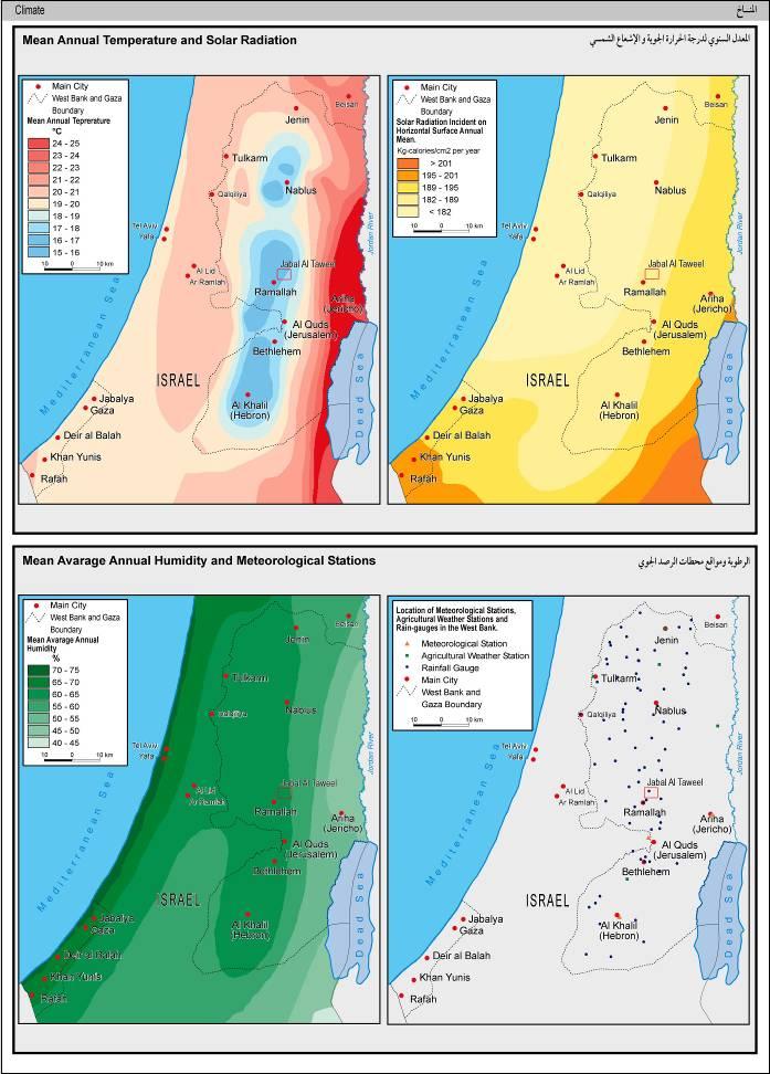
1 Jabal Al Taweel (Pesagot) Population: 1,464 inhabitants compromising 375 Families Year Founded: 1981 Distant from Jerusalem: 20 Km Location: branch road out of road 60 near Mochmas gas station Height: 906 M above Mean Sea Level Climate: Mountainous, Snow in winter Organizations: Benjamin area council, Benjamin community center, education institutions Main Works: Carpentry shops, printing. Average Annual Cloudiness No. of days per year / % Average Annual Rainfall / mm Mean Average Annual Humidity /% Slope in Degrees Aspect in Degrees ( 1) Solar Radiation Incident on Horizontal Surface Annual Mean Kg calories/cm 2 per year Mean Temperature of Coldest Month (January) C o Mean Temperature of hottest Month (August) C o Mean Annual Temperature C o Soil Type Terra Rossas Brown Rendzinas Geology (Lithology) Limestone, Dolomite, Marl (Cenomanian, Turonian) Physical Characteristics of Pesagot 1

2 2
3 3


4 History: Pesagot colony was first established in 1981, when the Israeli Benjamin Regional Council moved its premises from Beit Eale to Bour Mountain, called Jabel Al On the ground, the colonist activity started when a group of deserted Taweel. Caravans were moved from the Occupied Egyptian Sinai Peninsula to establish th e new council. The first colonist outposts, which settled in Jabel Al Taweel were originally moved from Karem Dbouna and Beit Vegan neighborhood, based in the West Jerusalem. 4
5 Colonization of Jabel Al Taweel in 1981 When the first five families started to settle down in the vicinity of Jabal Al Taweel, the indigenous population [Palestinians] raised a petition to the Israeli Civil High Court asking to stop the gross violations against their land and properties rights, by first freezing the colony anthropogenic growth and then by the restitution of the land. However, the Court stipulated in its verdict the heroes of the lawsuit. The municipality of Pesagot claims on its cyber page that Pesagot was mentioned in the Torah as a sacred site that is rich with monuments and historical evidences of the Jewish presence in the Kshmoneum period. Educational and Other Services: The educational institutions in the colony of Pesagot cover all needs of the public who live inside the colony and in the vicinity of the border region. The educational system provides its services on a regular base targeting the children s since they are born till the age of school entry. There is one nursery school for newly born children s and another four kindergartens hosting children s from the age of 3. Also, the colony has one co educational primary school designated for the children s up to the seventh grade. In addition to the curriculum education in the colony, there are different educational institutions working in different fields, namely; - An educational institution that aims at providing extracurricular and pedagogical days and seminars. - A governmental school that provide trips for the Benjamin, Jerusalem and Yahooda regions. - Melkam Center, which provide studies on different phenomena. - Shova Center for religious studies (explicitly for females). - Maklol Center, which accompany between religious studies and High Tic studies. The educational system of the colony is distinguished for having a pioneer project for law teaching and training on an institutional level that lasts for 5 7 years. 5

6 A picture for the Jewish Religious Institute in Pesagot (2007) In the colony there is one clink that is a part of the Israeli patient s box Kobat Holim. The majority of the colony residents work in Jerusalem, albeit alia, the many different successful projects and schemes inside the colony that extends to financial auditing, consultation, light industries (kids toys), carpentry shops, survey offices, contracting companies, and printing press. Now, Pesagot municipal council is preparing for constructing a new neighborhood, called the Eye of the Sun in the center of the colony in order to absorb more colonists in the foreseeable future. 6


7 Pictures showing the landscape around Pesagot (2007) 7

8 8

9 Location Map of Pesagot (2007) From the Israeli law point of view, Pesagot is considered an illegal outpost, as B etselem organization says that Pesagot masterplan has never been approved, bearing in mind that there was a yesteryear cabinet decision to establish the settlement. Masterplan of Pesagot (2005) 9

10 Pesagot 3 D Model 10

11 Main Architectural Typologies in Pesagot 11

12 12
 Built up area=zero")
13 Land Use /Land Cover of Pesagot (2006): Built Up Area in Pesagot ( ) Built up area=zero 13

14 Built up area=350, m 2 14

15 Built up area=564, m 2 15

16 Built up area=696, m 2 16
17 17
18 Population of Pesagot ( ) 18
Brief Description of Northern the West Bank, Palestine Prepared by: Dr. Ahmed Ghodieh Department of Geography An-Najah National University Nablus,
 Brief Description of Northern the West Bank, Palestine Prepared by: Dr. Ahmed Ghodieh Department of Geography An-Najah National University Nablus, Palestine Brief Description of Northern the West Bank
Deir Hajla Locality Profile
 Deir Hajla Locality Profile Prepared by The Applied Research Institute Jerusalem Funded by Spanish Cooperation 2012 Acknowledgments ARIJ hereby expresses its deep gratitude to the Spanish agency for International
Aqqaba Village Profile
 Aqqaba Village Profile Produced by The Applied Research Institute - Jerusalem In cooperation with Funded by February, 2006 This document has been produced with the financial assistance of the European
Chapter 16 ~ Eastern Mediterranean
 Chapter 16 ~ Eastern Mediterranean Physical Geography of the Eastern Mediterranean Landforms This area is known as the Levant and includes Syria, Jordan, Lebanon, Israel, and the Palestinian territories.
Chapter 16 ~ Eastern Mediterranean
 Chapter 16 ~ Eastern Mediterranean Physical Geography of the Eastern Mediterranean Landforms This area is known as the Levant and includes Syria, Jordan, Lebanon, Israel, and the Palestinian territories.
WP4 Sustainable Energy Action plans. Task 4.1 TARGET COMMUNITIES IDENTIFICATION D4.1.1 REPORT ON TARGET COMMUNITIES IDENTIFICATION
 WP4 Sustainable Energy Action plans Task 4.1 TARGET COMMUNITIES IDENTIFICATION D4.1.1 REPORT ON TARGET COMMUNITIES IDENTIFICATION Date: September Year 2015 release nr. 2 Author: FB13- Kotor Municipality
Deir al Qilt Locality Profile
 Deir al Qilt Locality Profile Prepared by The Applied Research Institute Jerusalem Funded by Spanish Cooperation 2012 Acknowledgments ARIJ hereby expresses its deep gratitude to the Spanish agency for
The Maltese Islands: Geography
 The Maltese Islands: Geography The Maltese Archipelago comprises a group of small low islands aligned in a NW-SE direction. At their extreme points the Maltese Islands fall within the following points:
Kosovo Roadmap on Youth, Peace and Security
 Kosovo Roadmap on Youth, Peace and Security Preamble We, young people of Kosovo, coming from diverse ethnic backgrounds and united by our aspiration to take Youth, Peace and Security agenda forward, Here
!!!!!!!!!!Mali s Geographic Makeup
 DANU Strategic Forecasting Group May 27th 2016!!!!!!!!!!Mali s Geographic Makeup By Liliana Pirlea Location: Mali is a landlocked country located in West Africa. Mali is the 8th largest country in Africa
The Prime Minister s decision to move forward with the Kedem Compound plan in Silwan and the Mount Scopus Slopes National Park
 The Prime Minister s decision to move forward with the Kedem Compound plan in Silwan and the Mount Scopus Slopes National Park Last Wednesday morning we learned the Prime Minister and the Minister of Interior
HISTORICAL AND SOCIAL SIGNIFICANCE PHOTOGRAPH: M.VAIR-PIOVA, 5/12/2014
 DISTRICT PLAN LISTED HERITAGE PLACE HERITAGE ASSESSMENT STATEMENT OF SIGNIFICANCE HERITAGE ITEM NUMBER 608 MILL ISLAND AND SETTING AVON RIVER BETWEEN HEREFORD-WORCESTER/71 HEREFORD STREET, 110 CAMBRIDGE
A day with Macedonian Archaeology Arheo Park Brazda
 A day with Macedonian Archaeology Arheo Park Brazda The archeological site Gradiste Brazda is situated nearly 15 km north of Skopje, on a humble hill that rises over the village of Brazda. According to
TAKING LEAVE COMPETITION
 TAKING LEAVE COMPETITION WHO?!! Social Reality A Vision to new Future Love To Be Together HOW?!! We will design our new City Social Reality I hope to be a doctor in my new City in the Western Desert Social
CHAPTER IV OVERVIEW. Indonesia. The capital is Dompu. Dompu Regency has an area of 2, km².
 CHAPTER IV OVERVIEW A. General Description of the Research Sites Dompu Regency, is a district in West Nusa Tenggara Province, Indonesia. The capital is Dompu. Dompu Regency has an area of 2,321.55 km².
PALMA Mediterranean Meeting Point. Presentation
 PALMA Mediterranean Meeting Point Presentation PALMA Mediterranean Meeting Point Presentation A. Presentation of the city... 5 1. PALMA TODAY... 10 2. GEOGRAPHICAL SURROUNDINGS... 11 3. HISTORIC CITY CENTRE...
Xaman-Ha city, an answer to the poor growth and spread population
 Xaman-Ha city, an answer to the poor growth and spread population Global aspect In The Mexican Republic we can found three zones with an important tourist movement; the metropolitan area of Mexico City,
Egypt is located in northeastern Africa and southwestern Asia. It covers 385,229 square
 Egypt Location Egypt is located in northeastern Africa and southwestern Asia. It covers 385,229 square miles. Egypt lies on the coordinates 27 N, 30 E. Libya lies on Egypt s west border, Sudan on its south,
Oceania. Australia, New Zealand, and the Pacific Islands. Physical Geography. Where is Australia located?
 Oceania Australia, New Zealand, and the Pacific Islands Physical Geography Australia New Zealand Oceania Where is Australia located? Australia & Oceania are a group of islands located between Asia, Antarctica,
6th Grade Social Studies Chapter 7: The Geography and Early Settlement of Egypt, Kush and Canaan
 I. Introduction (7.1) A. Egyptians settled along the Nile River, in the NE corner of Africa B. civilization lasted from around 3100 B.C. to 350 C. E. C. Kushites settled to the south of Egypt, along the
Beit Haliba and the Givati Parking Lot
 Beit Haliba and the Givati Parking Lot Archeological Excavations and their Effect on the Status Quo in the Old City of Jerusalem and in Silwan Introduction On February 13, 2012, the Jerusalem Building
Ancient Egypt. Life Along the Nile River
 Ancient Egypt Life Along the Nile River 2018 Geography How Does Geography affect the way that people live? Geography- Where in the World? You are Here Streetsboro, Ohio United States of America Geography-
ZIONIST PLAN FOR PALESTINE 1919 MAP 1
 ZIONIST PLAN FOR PALESTINE 1919 MAP 1 THE PEEL COMMISSION PARTITION PLAN, JULY 1937 MAP 2 Proposed Arab State Proposed Jewish State To Remain under British Mandate Aka Haifa Sur LEBANON Safad Proposed
EUROPEAN SKI ORIENTEERING CHAMPIONSHIP SARIKAMIŞ/TURKEY
 B U L L E T I N -1- EUROPEAN SKI ORIENTEERING CHAMPIONSHIP SARIKAMIŞ/TURKEY BULLETIN 1 ESOC 2019 4-12 February Sarıkamış-TURKEY 1. ORGANISERS TURKISH ORIENTEERING FEDERATION Event Director Assistant Event
Australian Geography. Standards:
 Australian Geography Standards: SS6G12 The student will be able to locate selected features of Australia. a. Locate on a world and regional political-physical map: the Great Barrier Reef, Coral Sea, Ayers
Executive Summary. State Party PALESTINE. State, Province or Region WESTBANK Hebron/Al-Khalil. Name of Property. Hebron/Al-Khalil Old Town
 Executive Summary State Party PALESTINE State, Province or Region WESTBANK Hebron/Al-Khalil Name of Property Hebron/Al-Khalil Old Town Geographical coordinates to the nearest second The property is located
SIAVONGA DISTRICT
 SIAVONGA DISTRICT --------------------------------------------------------------------------------------------------------- 1.0 Physical Environment Siavonga District is characterized by an escarpment
07 NIGHTS / 08 DAYS Starting from BATUMI. Per person in double
 07 NIGHTS / 08 DAYS Starting from $ BATUMI GEORGIA 25JUN Until 10SEP, 2017 794 Per person in double About Batumi Batumi is the second largest city of Georgia, located on the coast of the Black Sea in the
6th Grade Western Hemisphere Geography
 6th Grade Western Hemisphere Geography Multiple Choice Identify the choice that best completes the statement or answers the question. 1 Latin America is located in the A Northern Hemisphere. C Western
2007 Solar Radiation Summary
 Latitude 25 34' North, Longitude 8 28' West, Elevation 2 (m) Miami, Florida Solar Radiation Summary Year Total Solar Radiation Ultraviolet Solar Radiation Direct Underglass Direct Underglass Month 5 26
LAST TIME (Happy 300 th Birthday Ben Franklin!)
") LAST TIME (Happy 300 th Birthday Ben Franklin!) Latin American Diversity: Introduction Physical Geography of Mexico, Caribbean, and Central America: 1. Mexican drylands 2. Mesoamerican Highlands 3. Coastal
LAST TIME (Happy 300 th Birthday Ben Franklin!) Latin American Diversity: Introduction Physical Geography of Mexico, Caribbean, and Central America: 1. Mexican drylands 2. Mesoamerican Highlands 3. Coastal
GEOGRAPHY AND HISTORY
 GEOGRAPHY AND HISTORY YEAR 1, PART 1 www.vicensvives.es Contents 01 Our planet Earth 02 The representation of the Earth: maps 03 The Earth s relief 04 Rivers and seas 05 Weather and climate 06 Climates
Bardala village profile
 Bardala village profile Produced by The Applied Research Institute - Jerusalem In cooperation with Funded by February, 2006 This document has been produced with the financial assistance of the European
Gebel Barkal (Sudan) No 1073
 No 1073") Gebel Barkal (Sudan) No 1073 1. BASIC DATA State Party : Republic of Sudan Name of property: Gebel Barkal and the Sites of the Napatan Region Location: Northern state, province of Meroe Date received:
Gebel Barkal (Sudan) No 1073 1. BASIC DATA State Party : Republic of Sudan Name of property: Gebel Barkal and the Sites of the Napatan Region Location: Northern state, province of Meroe Date received:
EUROPEAN SKI ORIENTEERING CHAMPIONSHIP SARIKAMIŞ/TURKEY
 B U L L E T I N -1- EUROPEAN SKI ORIENTEERING CHAMPIONSHIP SARIKAMIŞ/TURKEY LL L BULLETIN 1 ESOC 2019 4-12 February Sarıkamış-TURKEY 1. ORGANISERS TURKISH ORIENTEERING FEDERATION Event Director Assistant
Spanish Colonies on the Borderlands
 Spanish Colonies on the Borderlands Pages 90 93 Nov 1 8:14 PM 1 Today's Objectives *Describe Spain s colony in Florida. *Explain how Spain established settlements throughout much of North America. *Describe
National parks WRITING
 National parks WRITING Content National parks were created to preserve natural habitats and allow people to visit and appreciate the natural beauty. Learning Outcomes Read about the purpose and characteristics
2.2 For these reasons the provision of tourist signing will only be considered:
 TOURIST SIGNING POLICY 2015 1. DEFINITION 1.1 A tourist destination is defined as a permanently established attraction which attracts or is used by visitors to an area and is open to the public without
Custom spanish courses for groups CUSTOM SPANISH COURSES FOR GROUPS MÁLAGA - SPAIN
 CUSTOM SPANISH COURSES FOR GROUPS MÁLAGA - SPAIN Custom spanish courses for groups SCHOOL DESCRIPTION Cervantes Escuela Internacional, with 30 years of experience in teaching Spanish as a foreign language,
Overview. On July 14, 2018, the central committee of Hamas' summer camps in the Gaza Strip held a
 Hamas announced the opening of summer camps for children and adolescents in the Gaza Strip. This year summer camps are inspired by the "return marches," and include military training as they do every year
Citizens in Action is a non-profit, non-governmental, voluntary youth organisation based in Athens.
 Summer Workcamps 20 13 TM 2013 Citizens in Action is a non-profit, non-governmental, voluntary youth organisation based in Athens. The aims of C.i.A are: To support and promote the idea of active citizenship
THE MUNICIPALITY of PROZOR-RAMA
 Bosnia and Herzegovina Federation of Bosnia and Herzegovina Herzegovina-Neretva Canton THE MUNICIPALITY of PROZOR-RAMA I T S D E V E L O P M E N T S T R A T E G Y B U S I N E S S ZONES S U B S I D Y S
Tourism. Guests and overnight stays West Jerusalem East Jerusalem Jerusalem compared to select Israeli cities Profile of the tourists Revenues
 Tourism Guests and overnight stays West Jerusalem East Jerusalem Jerusalem compared to select Israeli cities Profile of the tourists Revenues Tourism Overnight Stays of Foreign Tourists and Israelis in
CHAPTER 12. South America. Section 1: Natural Environments Section 2: History and Culture Section 3: South America Today. HOLT World Geography
 CHAPTER 12 South America Section 1: Natural Environments Section 2: History and Culture Section 3: South America 1 Section 1 Natural Environments Objectives: What are the major landforms and rivers of
Debris Flow & Shallow Landslide Protection
 Debris Flow & Shallow Landslide Protection NESSELWÄNGLE BEI REUTTE, AT NESSELWÄNGLE BEI REUTTE Debris Flow & Shallow Landslide Protection Project Nesselwängle bei Reutte Project number P10-500300 Street
Proposal for Pistol Australia to Host the 2019 WA1500 (PPC) World Championships in Australia
 World Championships in Australia") Proposal for Pistol Australia to Host the 2019 WA1500 (PPC) World Championships in Australia REPRESENTING AUSTRALIA REPRESENTING YOU 2019 WA1500 (PPC) World Championships Proposal Pistol Australia 1 2
Proposal for Pistol Australia to Host the 2019 WA1500 (PPC) World Championships in Australia REPRESENTING AUSTRALIA REPRESENTING YOU 2019 WA1500 (PPC) World Championships Proposal Pistol Australia 1 2
04 Nights / 05 Days Tour to Georgia (Kazbegi Tbilisi Kakheti)
") 04 Nights / 05 Days Tour to Georgia (Kazbegi Tbilisi Kakheti) Day 01 Kazbegi (15 th October 13) Stepantsminda a.k.a Kazbegi (Georgian: სტეფანწმინდა; formerly Kazbegi, ყაზბეგი), is a small town in the Mtskheta
04 Nights / 05 Days Tour to Georgia (Kazbegi Tbilisi Kakheti) Day 01 Kazbegi (15 th October 13) Stepantsminda a.k.a Kazbegi (Georgian: სტეფანწმინდა; formerly Kazbegi, ყაზბეგი), is a small town in the Mtskheta
The Geological Pacific Northwest. Wednesday February 6, 2012 Pacific Northwest History Mr. Rice
 The Geological Pacific Northwest Wednesday February 6, 2012 Pacific Northwest History Mr. Rice 1 Free Response #2 Please do not simply list the items for this response. Full sentences!!! Minimum of 3-5
2015 Brain Wrinkles. SS8G1b
 SS8G1b Standards SS8G1 The student will describe Georgia with regard to physical features and location. b. Describe the five geographic regions of Georgia; include the Blue Ridge Mountains, Valley and
ISRAEL- COUNTRY FACTS
 ISRAEL- COUNTRY FACTS ISRAEL-NEIGHBOURING COUNTRIES AND POLITICAL MAP Area: 22,072 sq. km Land area: 21,643 sq. km. Fast Facts Area of lakes: 429 sq. km. (Sea of Galilee 164 sq. km., the Dead Sea - 265
Chapter Test. History of Ancient Egypt
 Name Class Date MULTIPLE CHOICE Read each statement or question. On the lines below write the letter of the best answer. 1. Which of the following best describes why Herodotus called Egypt the gift of
What Is An Ecoregion?
 Ecoregions of Texas What Is An Ecoregion? Ecoregion a major ecosystem with distinctive geography, characteristic plants and animals, and ecosystems that receives uniform solar radiation and moisture Sometimes
Agrupamento de Escolas D. Maria II. Braga
 Agrupamento de Escolas D. Maria II Escola Básica nº2 de Lamaçães Braga Some facts about PORTUGAL: Official name: Republic of Portugal Location: Iberian Peninsula, West Europe; border with Spain and the
Mouthwatering. display. Features Cold Deli 3 Square. Cold Deli 3
 Mouthwatering display Cold Deli 3 The Cold Deli square is available in 3, 4 and 5 GN-pan sizes. Systems can be installed as drop-in versions in a counter or on a matching stand. For maximum flexibility,
Hadashot Arkheologiyot Excavations and Surveys in Israel 130
 Hadashot Arkheologiyot Excavations and Surveys in Israel 130 Be er Sheva, Nahal Ashan (Newe Menahem B): Modern Ammunition An assemblage of modern ammunition was found in an excavation conducted prior to
1st IIPT European Conference. Leeuwarden, October Tourism4Peace Forum. Challenges and Opportunities. Janos Damon
 1st IIPT European Conference Leeuwarden, 21-24 October 2008 Tourism4Peace Forum Challenges and Opportunities Janos Damon Executive Director, Israel Hotel Managers Association Secretary General, Tourism4Peace
THE IMPORTANCE OF NATURAL ELEMENTS FOR THE DEVELOPMENT OF TOURISM IN NEGORSKA SPA - GEVGELIJA IN MACEDONIA
 Socio economic geography; Teachnig & Education in Geography THE IMPORTANCE OF NATURAL ELEMENTS FOR THE DEVELOPMENT OF TOURISM IN NEGORSKA SPA - GEVGELIJA IN MACEDONIA DOI: http://dx.doi.org/10.18509/gbp.2015.41
SIMULATION OF URBAN GROWTH NEAR THE GREEN AREA OF AVENIDA BRASIL IN ANTOFAGASTA MIDTOWN, CHILE
 SIMULATION OF URBAN GROWTH NEAR THE GREEN AREA OF AVENIDA BRASIL IN ANTOFAGASTA MIDTOWN, CHILE M. PALME UNIVERSIDAD CATÓLICA DEL NORTE ESCUELA DE ARQUITECTURA 2nd World Sustainability Forum 1-30 November
Key Geographic Features
 DUE 12/6/18 Name: Lesson One: Egypt Geography 6.15 On a historical map locate the Mediterranean and Red Seas, the Nile River and Delta, and the areas of ancient Nubia and Egypt. Identify the locations
Location, Climate, & Natural Resources
 Location, Climate, & Natural Resources UK is a country of islands off the coast of mainland Europe. It consists of England, Northern Ireland, Scotland, & Wales. UK s location makes it a HUB for trade.
SYLLABUS : INCA ARCHITECTURE HRS. OF THEORY: 1 HRS. OF PRACTICE: 4 I. SUMMARY II. COMPETENCIES.
 SYLLABUS AREA : ARCHITECTURE COURSE : INCA ARCHITECTURE PREREQUISITE : CREDITS NO PREREQUISITE : (US Credits) HRS. OF THEORY: 1 HRS. OF PRACTICE: 4 I. SUMMARY The course is intended to introduce students
Ethnic Minorities in Alexandria, Egypt: Findings from the 1947and 1960 Population Censuses *
 Ethnic Minorities in Alexandria, Egypt: Findings from the 1947and 1960 Population Censuses * Ayman Zohry, Ph.D. Abstract Historically, Egypt was a land of immigrants not emigrants; a receiving rather than
Location, Climate, & Natural Resources Brain Wrinkles
 Location, Climate, & Natural Resources Standards SS6G10 The student will explain the impact of location, climate, natural resources, and population distribution on Europe. a. Compare how the location,
The Suez Canal Crisis. By: Nikki, Michael, Taylor, Kylee, Danica, and Michaela.
 The Suez Canal Crisis By: Nikki, Michael, Taylor, Kylee, Danica, and Michaela. Timeline 1953: Nasser introduces blockades/restricts Israeli commerce July 26th: Nasser announces nationalization of the Canal
EWA-WMCC in Spitsbergen practical information
 EWA-WMCC in Spitsbergen practical information We are warmly anticipating your arrival to Norway and Longyearbyen, the Norwegian capital of Spitsbergen. This letter outlines some important practical issues.
6th Grade Western Hemisphere Geography
 6th Grade Western Hemisphere Geography Multiple Choice Identify the choice that best completes the statement or answers the question. 1 Latin America is located in the A Northern Hemisphere. C Western
Physical characteristics and biomes:
 Physical characteristics and biomes: Sahel region, bordering Sahara Characteristics Area suffers from lack of rainfall, over grazing, which causes loss of vegetation and loss of inhabitable areas causing
NUMISMATIC COLLECTION NEWS AND ACTIVITIES
 December 2015 NUMISMATIC COLLECTION NEWS AND ACTIVITIES Alpha Bank Numismatic Collection, 41 Panepistimiou Street, GR-102 52, Athens. Tel.+30 210 326 2460-1 www.alphanumismatics.gr, numismatic@alpha.gr
the Webb Ranch Resort
 the Webb Ranch Resort Recreation... Privacy... Comfort... The Webb Ranch Resort is located approximately 6 miles northwest of Pinon, New Mexico. Featuring a beautifully designed, custom log home, the 212
Sacred Connections September 18 th September 30 th 2019
 Sacred Connections September 18 th September 30 th 2019 Lisa and Christine of Mercurial Connections are excited to announce another Sacred Connections tour of the beautiful regions of Greece. Come join
STUDY TOURS HANOI INTA 37 VIETNAM
 STUDY TOURS HANOI INTA 37 VIETNAM Date: 2 December 2013. Time: 13.00 to 17.00 Start Pullman Hanoi Hotel National Urban Planning Exhibition Palace Group 1: NEW NEIGHBORHOODS Group 2: HERITAGE HANOI Destination
SUPPORT TO WATER RESOURCES MANAGEMENT IN THE DRINA RIVER BASIN DRAFT ROOF REPORT INTRODUCTION AND GENERAL APPROACH
 SUPPORT TO WATER RESOURCES MANAGEMENT IN THE DRINA RIVER BASIN DRAFT ROOF REPORT INTRODUCTION AND GENERAL APPROACH Nadja Zeleznik, REC Public Concultation Beograd, Serbia, 4 July 2017 1 1. Introduction
"ST. KLIMENT OHRIDSKI FACULTY OF GEOLOGY AND GEOGRAPHY
 SOFIA UNIVERSITY "ST. KLIMENT OHRIDSKI FACULTY OF GEOLOGY AND GEOGRAPHY APPLICATION OF THE MODEL "DRIVING FORCES PRESSURE STATE - RESPONSE FOR ASSESSMENT OF FLOOD RISK RADOSTINA BORISOVA DOCHEVA Bachelor
ORTHOLOGICAL MANAGEMENT OF HYDROLOGICAL RUNOFF BASINS OF THE PREFECTURE OF DRAMA (CURRENT SITUATION PROTECTIVE ACTIONS PERSPECTIVES)
") ORTHOLOGICAL MANAGEMENT OF HYDROLOGICAL RUNOFF BASINS OF THE PREFECTURE OF DRAMA (CURRENT SITUATION PROTECTIVE ACTIONS PERSPECTIVES) This paper presents the torrential environment of the torrents of the
ORTHOLOGICAL MANAGEMENT OF HYDROLOGICAL RUNOFF BASINS OF THE PREFECTURE OF DRAMA (CURRENT SITUATION PROTECTIVE ACTIONS PERSPECTIVES) This paper presents the torrential environment of the torrents of the
Regional Radiocommunication Seminar (RRS 17 Arab) Muscat, Sultanate of Oman, December 2017
 Muscat, Sultanate of Oman, December 2017") Regional Radiocommunication Seminar (RRS 17 Arab), Sultanate of Oman, 10 1 December 2017 INFORMATION NOTE 1. VENUE OF THE SEMINAR Grand Millennium P.O. Box 17, P.C. 118, Sultanate of Oman Tel.: +968 2230
Regional Radiocommunication Seminar (RRS 17 Arab), Sultanate of Oman, 10 1 December 2017 INFORMATION NOTE 1. VENUE OF THE SEMINAR Grand Millennium P.O. Box 17, P.C. 118, Sultanate of Oman Tel.: +968 2230
EMBO/ FEBS/ISF WORKSHOP ON SYSTEMS DYNAMICS OF INTRACELLULAR COMMUNICATION - OVERCOMING DISTANCE IN SIGNALLING NETWORKS
 EMBO/ FEBS/ISF WORKSHOP ON SYSTEMS DYNAMICS OF INTRACELLULAR COMMUNICATION - OVERCOMING DISTANCE IN SIGNALLING NETWORKS Maale Hachamisha, Jerusalem Hills, Israel, March 18-22, 2007 ANNOUNCEMENT GENERAL
Concept Document towards the Dead Sea Basin Biosphere Reserve and World Heritage Listing. This report has been presented to the public and to
 Concept Document towards the Dead Sea Basin Biosphere Reserve and World Heritage Listing. This report has been presented to the public and to political decision makers both regionally and internationally
the basic principle of justice in Hammurabi s Code ( an eye for an eye ). (H, C, E)
. (H, C, E)") SEPTEMBER OCTOBER NOVEMBER HUMAN ORIGINS IN AFRICA THROUGH THE NEOLITHIC AGE 7.1 Describe the great climatic and environmental changes that shaped the earth and eventually permitted the growth of human
SEPTEMBER OCTOBER NOVEMBER HUMAN ORIGINS IN AFRICA THROUGH THE NEOLITHIC AGE 7.1 Describe the great climatic and environmental changes that shaped the earth and eventually permitted the growth of human
A Stillspeaking Journey Through the Holy Land Itinerary. December 29, 2017 January 11, 2018
 A Stillspeaking Journey Through the Holy Land Itinerary December 29, 2017 January 11, 2018 Day 1-2 / Friday December 29 - Saturday, December 30, 2017 - Depart from the United States and Arrive in Tel Aviv
Position Paper In the Air and Underground the Jerusalem Cable Car Project and its potential impact on the Historic Basin
 13 June 2017 Position Paper In the Air and Underground the Jerusalem Cable Car Project and its potential impact on the Historic Basin During a government meeting on Jerusalem Day (28 May 2017), the ministers
Central Africa Climate?
 Sub-Saharan Africa: All the lands below the Sahara List 4 common traits of countries in Sub-Saharan Africa 4. Define Tribalism and explain how it has affects the region. Chapter 20 Study Guide Define animism
Unit 9 The Middle East SG 1 - Physical Geography, Population & Demographics
 Unit 9 The Middle East SG 1 - Physical Geography, Population & Demographics I. Physical Geography A. The Middle East includes southwestern Asia and North Africa. 1. The name is Eurocentric. Middle East
Crete Study Site Description
 Crete Study Site Description 1. Location Crete (the largest island of Greece) is located in the south part of Greece covering an area of 8.335 km 2 or 6.3% of the Greek territory, including the surrounding
Appendix A Geographic and Geologic Terms Connected With Egypt
 Appendix A Geographic and Geologic Terms Connected With Egypt Egypt Official name is the Arab Republic of Egypt. Total area is 1,002,450 km 2, which makes Egypt the 29th largest country in the world. Only
Amesbury Elementary School
 Community Forum June 11, 2018 Amesbury Elementary School 2018 DiNisco Design, Inc. Agenda Project update Education goals Community and Faculty/Staff Survey Results Grade Configuration Schemes Next Steps!2
ABSTRACT MIXED INCOME HOUSING, A REVITALIZATION PROJECT IN MEDELLIN, COLOMBIA
 ABSTRACT Title of Thesis: MIXED INCOME HOUSING, A REVITALIZATION PROJECT IN MEDELLIN, COLOMBIA Roberto M. De Los Rios Master of Architecture, fall 2003 Thesis directed by: Professor William Bechhoefer
OF OLIVE. years old. (UN) (UN, 2008) 2009) 2010) (World Bank, 2008) Bank, 2008) Figure 1. (Source: UN) Page 1 / 6
 (UN, 2008) 2009) 2010) (World Bank, 2008) Bank, 2008) Figure 1. (Source: UN) Page 1 / 6") Policies - Montenegro 2012 1. GENERAL DESCRIPTION OF OLIVE GROWING IN MONTENEGRO 1.1. Introduction Figure 1. Location of Montenegro (Source: UN) Olive growing is concentrated along the coast of Montenegro
Policies - Montenegro 2012 1. GENERAL DESCRIPTION OF OLIVE GROWING IN MONTENEGRO 1.1. Introduction Figure 1. Location of Montenegro (Source: UN) Olive growing is concentrated along the coast of Montenegro
The Mamilla Cemetery in West Jerusalem A Heritage Site at the Crossroads of Politics and Real Estate
 The Mamilla Cemetery in West Jerusalem A Heritage Site at the Crossroads of Politics and Real Estate The Mamilla Cemetery with Jerusalem high-rises in the background Location and Significance The Mamilla
ROMAN-ETRUSCAN ETRURIA: CITIES AND STONE RESOURCES
 ROMAN-ETRUSCAN ETRURIA: CITIES AND STONE RESOURCES the case histories of Roselle and Cosa Roselle Cosa Prof. Geol. Massimo Coli, Dr. Geol. Michele Baldi, Dr. Jacopo Sabatini - Dip. Scienze della Terra
Poll no. 132 Date: February 15, 2005
 Poll no. 132 Date: February 15, 2005 Dear Madam, Dear Sir, We are very pleased to forward to you the summary of our latest poll No. (132), which has probed the resonance of Sharm el-sheikh summit results
Territory and Habitat
 1 Hauran 6 Physical Features Syria lies on the eastern coast of the Mediterranean Sea, bounded by Turkey in the north, Iraq in the east, Jordan in the south and Lebanon and the Mediterranean Sea in the
The City of Córdoba A Heroic Past
 The City of Córdoba A Heroic Past Cecilia Rábago* Mauricio Degollado Exact copy of the Treaties of Córdoba in the Municipal Palace. Córdoba is a privileged city. Stra te gi cal - ly located in central
Chapter 14. The Physical Geography of Russia
 Chapter 14 The Physical Geography of Russia Chapter Objectives Identify the physical features and natural resources of Russia. Discuss the effects of Russia s climate and vegetation on life in the region.
Assessment of Environmental Impacts of the proposed Sectoral Operational Programme for Tourism and Spa Industry
 Unofficial translation of the original document produced in Czech language Assessment of Environmental Impacts of the proposed Sectoral Operational Programme for Tourism and Spa Industry Assessment team:
Seminar for Teachers from Austria July 5-18, 2008 Room: Ostfeld Hall (6. to 11.7.) and Room 17 ( ) Tentative
 and Room 17 ( ) Tentative") Seminar for Teachers from Austria July 5-18, 2008 Room: Ostfeld Hall (6. to 11.7.) and Room 17 (13.-18.7.) Tentative Saturday, July 5 Arrival at airport Ben Gurion, transfer to Jerusalem, Guided Jerusalem
Seminar for Teachers from Austria July 5-18, 2008 Room: Ostfeld Hall (6. to 11.7.) and Room 17 (13.-18.7.) Tentative Saturday, July 5 Arrival at airport Ben Gurion, transfer to Jerusalem, Guided Jerusalem
THE CBC BLACK SEA PROJECT ALECT R
 Page 1 PROJECT FACTSHEET 06 THE CBC BLACK SEA PROJECT ALECT R Collaborative Networks of Multilevel Actors to advance Quality Standards for Heritage Tourism at Cross Border Level 2.1.2.73296.282 MIS ECT
THAILAND, LAOS & CAMBODIA
 THAILAND, LAOS & CAMBODIA 31 DAYS An expedition for the bona fide explorer! Your journey will encompass some of the most dramatic scenery and fascinating aspects of each country. Trek through the jungles
The Beginnings of Rome Quiz Study Guide
 The Beginnings of Rome Quiz Study Guide Quiz: What to Know The Legendary founding of Rome (Romulus and Remus) The three groups that inhabited Rome The areas where each group settled Why did groups choose
Cornucopia Ranch. the
 Cornucopia Ranch the Majestic mountains... Rolling hills... Vast meadows... are all part of the beautiful landscape of the Cornucopia Ranch. Located just 40 miles from Cloudcroft, New Mexico, the Cornucopia
Namibia, formally The Republic of Namibia, is located in the southwestern region
 Namibia Location Namibia, formally The Republic of Namibia, is located in the southwestern region of the continent of Africa. Its western boarder is Atlantic coastline. Namibia borders The Republic of