SNOW AVALANCHES IN PROVO CANYON, UTAH
|
|
|
- Tamsyn Stewart
- 5 years ago
- Views:
Transcription
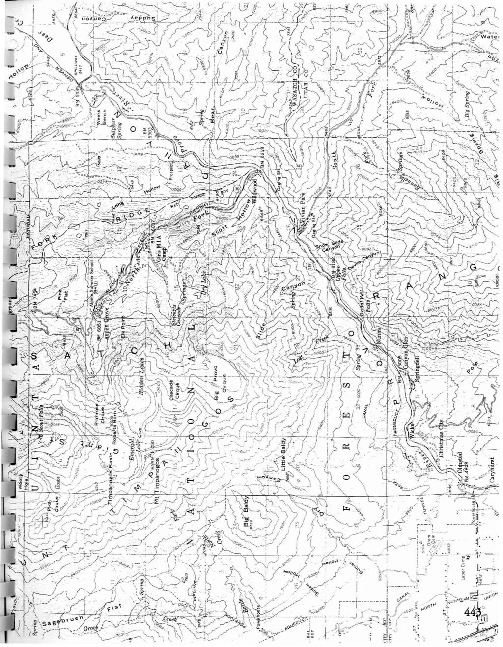
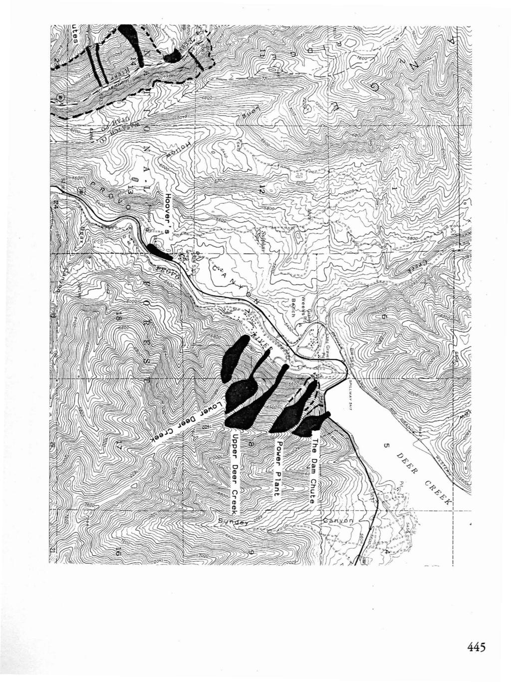
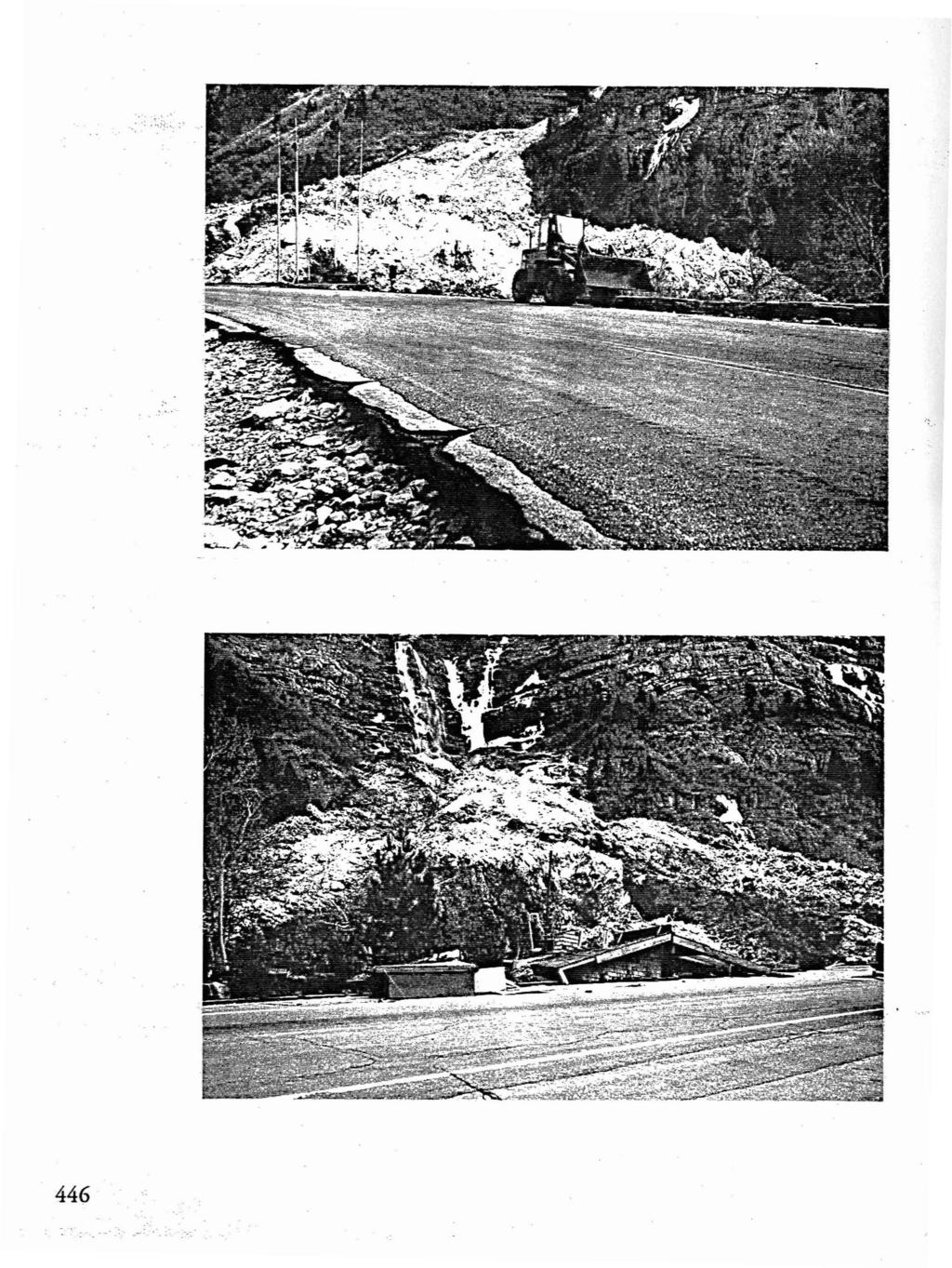
1 SNOW AVALANCHES IN PROVO CANYON, UTAH KEVIN GRIFFITH REGION THREE AVALANCHE FORECASTER UTAH DEPARTMENT OF TRANSPORTATION 825 NORTH 900 WEST OREM, UTAH USA (801 ) TEL (801 ) FAX This paper discusses theutah Department oftransportation's (UDOT) implementation of an avalanche forecasting and explosive control program for the avalanche paths that threaten US Highway 189.This section of US Highway 189 is located in Utah's Wasatch Mountains between the of city Orem and Deer Creek Reservoir. UDOT Region Three's jurisdiction also includes the avalanche paths inamerican Fork Canyon and Daniels Canyon although they will not be discussed in this paper. Until January 1994 UDOT did not have a full-time program to control avalanches on US Highway 189. UDOT instead relied upon its avalanche forecasters located in Little and Big Cottonwood Canyons. Thesecanyons are locatedapproximately29 km (18 miles) to the north by air. Highway travel distance is approximately 65 km (40 miles). Because these UDOT forecasters spent a considerable amountoftime (often twenty-four hours a day) controlling the frequent avalanches that crossutah State Road 210 in Little Cottonwood Canyon and Utah State Road 190 in Big Cottonwood Canyon, they were only able to perform sporadic avalanche forecasting and control in Provo Canyon. The geography and weather in the northern Utah mountains often prevented these forecasters from traveling to Provo Canyon since storm and avalanche cycles often make mountain travel nearly impossible. UDOT Snow and Avalanche Atlas for Provo Canyon (US 189) describes Provo Canyon as follows: Provo Canyon is a southwest to northeast running corridor cut through the central Wasatch Mountains by the Provo River. The elevation at the canyon mouth is 1472 meters (4830 feet) and rises to 1651 meters (5417 feet) at the Deer Creek Dam where the highway leaves the canyon. The north side oftie canyon consists of the south flank of Mt. Timpanogos and rises to 3245 meters (10645 feet). The south side ofthe canyon rises to 3023 meters (9917 feet) and consists ofthe north end of Cascade Mountain. Slide Canyon, BridalVeil Falls, and Lost Creekarethe three largest slide paths in the state ofutah that threaten a year-round highway. Fortunately, they only cross the highway on an infrequent basis, but WIen they do they can cause 439

2 severe damage. The Dam Chute, insignificant by comparison, can hit the highway three to four times a year. Since the publication ofthe above mentioned atlas, US Highway 189 has been relocated slightly to the north and widened from two lanes to four lanes in the runout zones of Slide Canyon, Bridal Veil Falls, and Lost Creek. Planning is currently underway to widen the existing two lanes to four lanes for the rest of Provo Canyon. Design and location of this highway expansion is not yet complete so the affect on the avalanche control program is unknown. Avalanche activity at the Dam Chute will require changes to be included in the updated atlas, with avalanches hitting the highway seven times during the winterof (One caught an eighteen wheel truck weighing 20,500 kilograms (45,000 pounds) sweeping it partially offthe highway.) The same avalanche path did not cross the highway once the next winter. In January 1994, UDOT hired an avalanche forecaster for Provo, Daniels, and American Fork Canyons. Avalanche forecasting and control here requires winter access to the starting zones ofslide Canyon, Lost Creek, Bridal Veil Falls, the Dam Chute, and numerous others. Access is often difficult, always time consuming, and is described below. Ifweather and avalanche conditions permit, access to Slide Canyon and Lost Creek starting zones can begin by driving up Provo Canyon 8.9 kilometers (5.5 mile;) then 4.8 km (3 miles) up the North Fork of Provo Canyon on Utah State Road 92 (SR 92) to the base of Sundance Ski Area. Of course this route travels across numerous avalanche paths. After riding two chair lifts from the base ofsundance Ski Area, access on foot commences at 2500 meters (8200 feet). From this point, the main starting zone for Slide Canyon is 2.4 km (1.5 miles) to the west at 3230 meters (10,600 feet); the main starting zone for Lost Creek is 0.8 km (0.5 miles) farther west at the same elevation. This route is the fastest access to these starting zones, and has become the most frequently used for snowpack and weather observations, as well as explosive avalanche control with hand charges. Access to the Dam Chute is by foot from the southeast end ofdeer Dreek Dam (on US Highway 189) ascending from 1651 meters (5417 feet) to 2012 meters (6600 feet) in a distance of 0.6 km (0.4 miles). Access to the starting zones ofbridal Veil Falls, like all the avalanche pathson the south side of Provo Canyon is by foot from the canyon floor. Forecasts relied upon the following avalanche forecasting methods: Snowpack and weatherdata was obtained during field trips to starting zones and study plots. This was supplemented with data from UDOT's avalanche forecasters in Little and Big Cottonwood canyons, avalanche forecasters at the Sundance Ski Area, and UDOT maintenance personnel working in snow removal operations. Snow study plots were implemented at the following locations: (1) Aspen grove, follow SR km (6 miles) from Provo canyon, elevation 2100 meters (6900 feet); (2) Dam Chute, follow US Highway km (2000 feet) north from the southeast end of deer creek Dam, elevation 1676 meters (5500 feet); and (3) three study plots at Sundance Ski Area, elevations at 1859 meters (6100 feet), 2134 meters (7000 feet), 2438 meters (8000 feet). 440
3 Snowpit and weather data collected during field trips provides the only local data available with the exception ofthat supplied by Sundance Ski Area and UDOT maintenance personnel on the highway. The information that Sundance provides is valuable, but has limited value for avalanche hazard evaluation in Provo Canyon. A.valanche forecasting in Provo Canyon requires daily field observations at a variety oflocations especially at higher elevations due to the absence of any remote weather stations. This necessitates explosive control work by field observers forsafe access to starting zones. The. large expanse of terrain in the Provo Canyon mandates the use of h elicopters for explosive avalanche control to reduce the chances of avalanches striking US Highway 189. The following is an example of a typical storm and avalanche cycle in Provo Canyon. Snowfall began February 17, 1994 with 24 cm (9.5 in) snow, 3.18 cm (1.25 in. H2O) by the morning of the 18th. Snowfall continued with additional accumulation of 37 cm (14.5 in.) snow, 3.96 cm (1.56 in.) H2O by the morning of the 20th. By this point in time numerous spontaneous avalanches had run with starting zone elevations as low as 2620 meters (8500 feet) and debris in Slide Canyon down to 1950 meters (6400 feet). This meant that approximately 1.5 km (4000 feet) horizontally and 300 meters(1000 feet) vertically of the track and runout zone remained dry to absorb additional activity before an avalanche could reach the highway. By 5:30 am on the 21st additional precipitation at Aspen Grove was 23 cm (9 in.) snow, 1.63 cm (0.6lin.) H2O. About an hour later a spontaneous awlanche released depositing debris 15 meters (50 feet) deep within 60 meters (200 feet) ofthe highway. Weather did notpermit aerial bombing until the 23rd; although this produced spectacular results none of the resulting avalanches hit the highway. REFERENCES Snow Avalanche Atlas Provo Canyon Compiled and edited by Dan Judd Photography Snow Avalanche Atlas Provo Canyon Dan Judd, Darwin Stoneman,&Rick Wyatt Contributors Snow Avalanche Atlas Provo Canyon Carl Craner-UDOT District Six Engineer Jim Ozmond-Denver Rio Grand Railroad Mike Schinderling-Sundance Ski Resort Greg Smith- Wasatch Powderbirds Darce Trotter-Sundance Ski Patrol Director Photographs Included Gerald Peterson-UDOT Photographer 441

4 , '" :~, \ ~ -,, CEDAR FOAT, ~ J '; \ )...,.~ FaulleJa ~ "',.,..' c'.: I SALT LAKE CITY OGDEN PROVO AND VICINITY o S = For Explanation of Map Symbols i'~ reverse side 4Li.i,coPyngh, If) Ul;_Jh ljl:'parlmenl olllihl:jwflijhon 4 Lake Shore 5
5

6 ;.. ;<>).,,t:p: B;'i'd;'i"'V~;l-F;'l-l';""'~ t\\~uh.~'1'i#!,fiiw;iiii,\,~ ~ ~ ~
7 445
8 446

9 BRIDAL VEIL FALLS, SPRING

10 448 BRIDAL VEIL FALLS, SPRING 1986
International Snow Science Workshop
 A PRACTICAL USE OF HISTORIC DATA TO MITIGATE WORKER EXPOSURE TO AVALANCHE HAZARD Jake Elkins Jackson Hole Mountain Resort, Teton Village, Wyoming Bob Comey* Jackson Hole Mountain Resort, Teton Village,
Excelsior Pass Avalanche Accident January 1, 2008
 Excelsior Pass Avalanche Accident January 1, 2008 Accident Summary Time: 1 January 2008, approximately 13:00 hrs Location: Near Excelsior Pass to east of Church Mt, Northern Washington Cascades WA Activity:
MP : Blue Hill and the Disney Avalanche Path
 MP 252-253: Blue Hill and the Disney Avalanche Path This section of the Auto Tour includes a portion of the wagon road, one of Colorado s most famous avalanches and the remains of an old dam. Route Mile
THRESHOLD GUIDELINES FOR AVALANCHE SAFETY MEASURES
 BRITISH COLUMBIA MINISTRY OF TRANSPORTATION & INFRASTRUCTURE AVALANCHE & WEATHER PROGRAMS THRESHOLD GUIDELINES FOR AVALANCHE SAFETY MEASURES British Columbia Ministry of Transportation & Infrastructure
TUPPER DESIGNATED ACCESS ROUTE
 TUPPER DESIGNATED ACCESS ROUTE 1 FOR ACCESS/EGRESS TO CONNAUGHT, LOOKOUT, STONE ARCH, PORTAL PATHS AND TUPPER TRAVERSE EGRESS Length: 2.6km Vertical Gain: +162m / -83m (Values are for access. For egress,
RE: Extreme Avalanche Hazard at New Jumbo Glacier Resort (JGR) Daylodge Building Site
 Daylodge Building Site") To: Ms. Autumn Cousins Manager, Policy and Compliance BC Environmental Assessment Office, via Email to autumn.cousins@gov.bc.ca and eao.compliance@gov.bc.ca PO Box 9426 Stn Prov Govt Victoria, BC V8W 9V1
To: Ms. Autumn Cousins Manager, Policy and Compliance BC Environmental Assessment Office, via Email to autumn.cousins@gov.bc.ca and eao.compliance@gov.bc.ca PO Box 9426 Stn Prov Govt Victoria, BC V8W 9V1
MP : the top of the bottom switchback
 MP 237 238: the top of the bottom switchback For reference this section of U S Highway 40 has been called the top of the bottom switchback on the Grand County side of the Pass. It is here that the proposed
Proceedings, International Snow Science Workshop, Breckenridge, Colorado, 2016
 THE WHITE PASS AND YUKON ROUTE AVALANCHE PROGRAM, FORECASTING AND RISK MAN- AGEMENT FOR A HISTORICAL RAILROAD Bill Glude Alaska Avalanche Specialists, Juneau, AK The White Pass and Yukon Route (WPYR) is
Proceedings, 2012 International Snow Science Workshop, Anchorage, Alaska
 I-90 SNOQUALMIE PASS: OPERATING A HIGHWAY AVALANCHE PROGRAM DURING A MAJOR CONSTRUCTION PROJECT John Stimberis, Washington State Department of Transportation ABSTRACT: Snoqualmie Pass, WA (921m) receives
American Avalanche Association Forest Service National Avalanche Center Avalanche Incident Report: Long Form
 American Avalanche Association Forest Service National Avalanche Center Avalanche Incident Report: Long Form Please send to: CAIC; 325 Broadway WS1; Boulder CO 80305; caic@qwest.net; Fax (303) 499-9618
Slot Couloir Accident, Snoqualmie Mt
 Body Page 1 Slot Couloir Accident, Snoqualmie Mt 4-27-14 Date and Time: estimated 12 pm, Sunday 4/27/14 Location: Slot Couloir, Snoqualmie Mt Number in Party: 2 backcountry skiers Number hurt: 1 backcountry
Morning Star Peak Avalanche Accident
 Morning Star Peak Avalanche Accident Saturday, December 4, 2010 Date: 2010-12-13 Submitted by: Oyvind Henningsen Everett Mountain Rescue and Mark Moore NWAC Place: Morning Star Peak, north-central WA Cascades
International Snow Science Workshop
 Chinook Pass: 25 Years On John Stimberis*, Washington State Department of Transportation, Snoqualmie Pass, Washington, USA ABSTRACT: Washington State Route 410 over Chinook Pass (1656 m) is generally closed
Avalanche Hazard Investigations, Zoning, and Ordinances, Utah, Part 2
 Avalanche Hazard Investigations, Zoning, and Ordinances, Utah, Part 2 David A. Scroggin, Jack Johnson Company L. Darlene Batatian, P.G., Mountain Land Development ABSTRACT: The Wasatch Mountains of Utah
Jumbo Glacier Resort Master Plan Appendix 2-A
 Jumbo Glacier Resort Master Plan Appendix 2-A Avalanche Studies and Reports prepared by P. Schaerer of Stetham & Associates Pheidias Project Management Corp. Copyright June, 2005 JUMBO
Berg Ridge BERG RIDGE 1
 Berg Ridge BERG RIDGE 1 Berg Ridge: $13,650,000 ($75,000 / ERU) Jordanelle Basin Wasatch County, Utah LOCATION: North Central Utah in the Jordanelle Basin of Wasatch County a 45-minute drive from downtown
In southern Upper Valais a very high avalanche danger will be encountered in some regions Edition: , 08:00 / Next update: 9.1.
 Page 1/6 In southern Upper Valais a very high avalanche danger will be encountered in some regions Edition: 9.1.2018, 08:00 / Next update: 9.1.2018, 17:00 Avalanche danger updated on 9.1.2018, 08:00 region
Henderson Mountain Avalanche Accident Two riders caught, one partially buried, one fully buried
 Henderson Mountain Avalanche Accident Two riders caught, one partially buried, one fully buried Custer-Gallatin National Forest 28 November 2014 Synopsis A group of 6 or 7 snowmobilers (part of a larger
Avalanche Observations
 Avalanche Observations Avalanche Observations 3.1 Introduction Observations of past and present avalanche activity are of the utmost importance for any avalanche forecasting operation. These data should
Proceedings, International Snow Science Workshop, Breckenridge, Colorado, 2016 ANALYSIS OF UTAH AVALANCHE FATALITIES IN THE MODERN ERA
 ANALYSIS OF UTAH AVALANCHE FATALITIES IN THE MODERN ERA Drew Hardesty 1 * 1 Utah Avalanche Center ABSTRACT: The Utah Avalanche Center (UAC) has records of Utah avalanche fatalities for the modern era,
WASATCH FRONT SUMMER ITINERARY
 WASATCH FRONT SUMMER ITINERARY SINGLE DAY TOUR / OPTION 1 The Salt Lake Valley sits against the beautiful Wasatch Mountains, and they should be experienced up close. After breakfast, we will drive up Little
NWAC Blog. Cornices - don't walk the line! Written by Robert Hahn on March 14, Last update on May 15, 2017.
 NWAC Blog Cornices - don't walk the line! Written by Robert Hahn on March 14, 2017. Last update on May 15, 2017. Human-triggered cornice fall avalanche from March 10th, 2017. The crown release exposed
Avalanche danger high in parts of NCW
 3/23/2017 Avalanche danger high in parts of NCW THURSDAY, MARCH 23, 2017 Avalanche danger high in parts of NCW by Christine Pratt Public Safety Feb. 9, 2017, 4:52 p.m. Photo provided An avalanche hit the
Guidelines for Snow Avalanche Risk Determination and Mapping. David McClung University of British Columbia
 Guidelines for Snow Avalanche Risk Determination and Mapping David McClung University of British Columbia Why do we need guidelines? Costs: 14 fatalities/year, $0.5 M/year property damage, $10 M/year avalanche
LEVEL 1 - AVALANCHE OVERVIEW HANDOUT
 Bill Glude Alaska Avalanche Specialists 20111202 All photos and graphics Bill Glude unless otherwise noted. LEVEL 1 - AVALANCHE OVERVIEW HANDOUT Summary of Key Points Statistics 1 2 3 Urban Avalanches
a. The historic avalanche areas, or areas in which there exists clear evidence of previous avalanches, are mapped.
 1 OBJECTIVES AND LIMITATIONS OF STUDY ;J'-o~ 1 j 1.1 BACKGROUND AND STUDY OBJECTIVES The communities of Aspendell, Habegger's, and Sage Flat are located in the eastern Sierra Nevada west of the towns of
SYNOPSIS WEATHER AND SNOWPACK
 Peak 6996 Avalanche Fatality Incident Report Glacier National Park, MT Date of Avalanche: 31 March 2010 Date of Investigation: 2 April 2010 Investigation Team: Erich Peitzsch (USGS), Ted Steiner (Chugach
Typical avalanche problems
 Typical avalanche problems The European Avalanche Warning Services (EAWS) describes five typical avalanche problems or situations as they occur in avalanche terrain. The Utah Avalanche Center (UAC) has
Proceedings, International Snow Science Workshop, Breckenridge, Colorado, 2016
 AVALANCHE FORECASTING AND MESSAGING FOR UNUSUAL AVALANCHE CONDITIONS IN A MARITIME SNOW CLIMATE-BURIED SURFACE HOAR INTERNATIONAL SNOW SCIENCE WORKSHOP 2016 IN BRECKENRIDGE, CO Steve A. Reynaud Sierra
TAYLOR CANYON RANCH COLORADO - ROUTT COUNTY - STEAMBOAT SPRINGS
 TAYLOR CANYON RANCH COLORADO - ROUTT COUNTY - STEAMBOAT SPRINGS Tucked up against the steep valley shaped by Mt. Pau and rising to the Routt National Forest, Taylor Canyon Ranch is an easily accessible,
Skiing and Snowshoes on Un-groomed Fernan Saddle Terrain
 Skiing and Snowshoes on Un-groomed Fernan Saddle Terrain Three ski or snowshoe routes are available from the Fernan Saddle Parking Lot which either do not cover routes ordinarily groomed for snow machine
Avalanche accident case study: Persistent buried weak layer in the Central Idaho Mountains
 Avalanche accident case study: Persistent buried weak layer in the Central Idaho Mountains Doug Abromeit* Forest Service National Avalanche Center Bozo Cardozo Sun Valley Helicopter Ski Guides Ketchum,
2/16/2014 Idaho Frenchman Creek Published by Scott Savage, SAC
 Location: Place Frenchman Creek drainage, Smoky Mountains State Idaho Date 2/16/2014 Time 2:00pm Summary 4 snowmobilers buried, 1 killed, 1 injured Number: Caught 4 Fully Buried 4 Injured 1 Killed 1 Avalanche
Going-to-the-Sun Road, Glacier National Park, MT, USA Avalanche Path Atlas
 Going-to-the-Sun Road, Glacier National Park, MT, USA Avalanche Path Atlas Erich H. Peitzsch Daniel B. Fagre USGS Northern Rocky Mountain Science Center West Glacier, MT, USA Introduction... 2 Overview
Avalanche Awareness and Leading a Companion Rescue
 Avalanche Awareness and Leading a Companion Rescue Introduction: Traveling in the backcountry is a great way to enjoy the outdoors and friends. It s important that when we travel in the backcountry we
Risk Assessment in Winter Backcountry Travel
 Wilderness and Environmental Medicine, 20, 269 274 (2009) ORIGINAL RESEARCH Risk Assessment in Winter Backcountry Travel Natalie A. Silverton, MD; Scott E. McIntosh, MD; Han S. Kim, PhD, MSPH From the
Twin Lakes Avalanche Incident 1/31/2016
 Twin Lakes Avalanche Incident 1/31/2016 Location: Place State Published by: Dave Bingaman (PAC), George Halcom (PAC), and Kent May (PAC) Twin Lakes, Salmon River Mountains Idaho Date 01/31/2016 Time Summary
Woodland Mountain Property
 Woodland Mountain Property So Close, Yet So Far Away Summit County, Utah 5 Acres $79,000 3616 Elmwood Street, Salt Lake City, UT 84106 801-870-1801 info@landrancher.com Welcome to Woodland Mountain Enjoy
Crystal Mountain Snow Safety Union Creek Avalanche Accident Report December 2, 2007
 Crystal Mountain Snow Safety Union Creek Avalanche Accident Report December 2, 2007 Prepared by Paul Baugher, Chris Morin, Crystal Mt Ski Patrol/ Snow Safety and Mark Moore, NWAC Accident Summary Time:
PROPOSED ACTION South 3000 East Salt Lake City, UT United States Department of Agriculture
 United States Department of Agriculture Forest Service Uinta-Wasatch-Cache National Forest Salt Lake Ranger District 6944 South 3000 East Salt Lake City, UT 84121 801-733-2660 File Code: 1950/2300 Date:
Project Update Utah Water Users Workshop March 14, 2012
 Project Update Utah Water Users Workshop March 14, 2012 Jeffrey D. Budge, P.E. Operations and Engineering Manager Steven H. Cain Facilities and Lands Manager Organized in 1935 Deer Creek Division of the
Corona Bowl Avalanche Incident, December 6th, 2015
 Corona Bowl Avalanche Incident, December 6th, 2015 Report prepared by NWAC and Stevens Pass Pro Patrol Incident snapshot Time and Date: 11:48 AM, December 6 th, 2015 Location: Corona Bowl, Chief Mountain,
Snow and Avalanches. Forest Service Utah Avalanche Center. Annual Report
 Annual Report 2003-04 Snow and Avalanches Annual Report 2003-2004 In partnership with: Utah State Parks and Recreation Friends of the Utah Avalanche Center National Weather Service Utah Division of Comprehensive
Creatures Of Habitat. Mark Hengesbaugh. Published by Utah State University Press. For additional information about this book
 Creatures Of Habitat Mark Hengesbaugh Published by Utah State University Press Hengesbaugh, Mark. Creatures Of Habitat: The Changing Nature of Wildlife and Wild Places in Utah and the Intermountain West.
BRYCE CANYON COUNTRY. A twisted tree endures rugged life on the rim of the Paunsaugunt Plateau.
 BRYCE CANYON COUNTRY Grand Staircase - Paunsaugunt Plateau Scenic backways itinerary A twisted tree endures rugged life on the rim of the Paunsaugunt Plateau. Travel to Bryce Canyon Country. Lodging check-in,
ENVIRONMENTAL HAZARDS OF AVALANCHES: PRELIMINARY RESEARCH IN GLACIER NATIONAL PARK
 ENVIRONMENTAL HAZARDS OF AVALANCHES: PRELIMINARY RESEARCH IN GLACIER NATIONAL PARK Site Focus: Balu Pass, Glacier National Park, B.C. Avalanche path near Balu Pass. (Photo Courtesy of: www.leelau.net/2007/rogerspass/day1/1)
Number Caught: 2 Partially Buried, Non-Critical: 1 Partially Buried, Critical: 0 Fully Buried: 1 Injured: 1 Killed: 1
 South Waldron Creek Avalanche Fatality 2 snowmobilers caught, 1 carried and injured, 1 fully buried and killed. Teton River, MT Helena-Lewis and Clark National Forest January 5 th, 2019 Avalanche Details
HOME LAYOUTS LAYOUT TOUR DESCRIPTIONS UPDATED 5/26/17. MIKE BENNETTE O Scale. JIM BARTA HO Scale. Nine Mile Falls, WA.
 LAYOUT TOUR DESCRIPTIONS UPDATED 5/26/17 HOME LAYOUTS JIM BARTA MIKE BENNETTE O Scale Nine Mile Falls, WA Deer Park, WA This large home scale layout has only been under construction only 18 months, but
Sequoia & Kings Canyon National Parks Fire Update
 Fire Update For Immediate Release September 28, 2004 Grant West Prescribed Fire Begins Today Today, fire crews will use hand-held drip torches to ignite 60 acres of the Grant West Prescribed Fire in Kings
BUCK POINT RANCH. Aspen Associates Realty
 BUCK POINT RANCH Aspen Associates Realty www.aspenassociatesrealty.com 970.544.5800 WELCOME TO Buck Point Ranch is a 960± acre property located in one of the last pristine valleys in close proximity to
EPPERSON INDUSTRIAL PARK
 EXCLUSIVE LISTING FUTURE INDUSTRIAL SITE ±680 ACRES SALT LAKE CITY, UTAH 3300 N Subject 40.54 acres 3200 W 550.46 acres 40.17 acres 2100 N 40.09 acres Sold Future State Prison Site ± 325 Acres Haul Road
26 Utah s Patchwork Parkway SCENIC BYWAY CORRIDOR MANAGEMENT PLAN (SR 143)
") Natural Natural Quality applies to those features in the visual environment that are in a relatively undisturbed state. These features predate the arrival of human populations and may include geological
Natural Natural Quality applies to those features in the visual environment that are in a relatively undisturbed state. These features predate the arrival of human populations and may include geological
ABSTRACT. Copyright Environment Canada, Canadian Parks Service, 1989
 KEL^LZ3 ABSTRACT The Rogers Pass avalanche defence operation protects a 40 km segment of highway and railway corridor centered on Rogers Pass. Glacier National Park, British Columbia. Canada. One hundred
BLASTING GLACIAL ICE AND SNOW ABSTRACT
 BLASTING GLACIAL ICE AND SNOW HERB BLEUER ABSTRACT This presentation, with the aid of slides, is about methods of blasting large quantities of glacial ice and snow. The project illustrated here involved
Bryce Canyon Country ATV Multi-Day Itinerary
 Bryce Canyon Country ATV Multi-Day Itinerary Look for more trail information and maps on these web-sites listed below. www. Casto Canyon Kick off your ATV adventure with this 36 mile round-trip ride through
SNOW DOUGHNUTS, BEACON CHECKERS, BLAST TRAILERS AND OTHER LOW COST TOOLS FROM THE FIELD
 SNOW DOUGHNUTS, BEACON CHECKERS, BLAST TRAILERS AND OTHER LOW COST TOOLS FROM THE FIELD Mike Stanford, Forecaster Washington State Department of Transportation Leavenworth Washington USA 509-667-2817 stanfom@wsdot.wa.gov
90 I-90 Snoqualmie Pass East September Annual Mega-Project Report. Project Benefits
 90 I-90 Snoqualmie Pass East September 2015 Annual Mega-Project Report Purpose of this Report The financial and schedule information in this document will assist the Office of Financial Management in meeting
BST Coalition Annual Report 2012 Table of Contents
 BST Coalition Annual Report 2012 BST Coalition Annual Report 2012 Table of Contents Introduction... 2 Progress Reports... 4 BST Committee General Efforts... 4 County by County Progress Reports... 5 Cache
Avalanches and the Mount Whitney Basin
 Avalanches and the Mount Whitney Basin 10 April 2006 by Bob Rockwell Prelude Avalanches are a fact of life in high mountains in winter, and we take courses to find out about them. We learn how to assess
Snow Lake Divide Avalanche Fatality February 25th, 2018
 Snow Lake Divide Avalanche Fatality February 25th, 2018 Report by Jeremy Allyn and Dennis D Amico, Northwest Avalanche Center Incident snapshot: Occurrence Time and Date: February 25, 2018 (estimated time:
Hiking Las Vegas.com
 Hike: Mt. Wilson via First Creek Canyon route Trailhead: First Creek marked Distance: 10 miles up and back Elevation gain: 3,400 feet Elevation of Peak: 7,070 feet Time: 7 to 9 hours (up and back) Difficulty:
Elevation Bands Description of terrain characteristics to which the avalanche danger ratings apply.
 1 Definition of Terms used in Daily Trip Forms This document is part of Decision Making in Avalanche Terrain: a fieldbook for winter backcountry users by Pascal Haegeli, Roger Atkins and Karl Klassen and
UNITED STATES DEPARTMENT OF THE INTERIOR BUREAU OF RECLAMATION REGION 4 SALT LAKE CITY, UTAH. May 29, 1958
 UNITED STATES DEPARTMENT OF THE INTERIOR BUREAU OF RECLAMATION REGION 4 SALT LAKE CITY, UTAH May 29, 1958 FACT SHEET ON PRIME CONTRACT FOR CONSTRUCTION OF FLAMING GORGE DAM GENERAL INFORMATION Bids will
MP : Headwaters of the Fraser River
 MP 236 237: Headwaters of the Fraser River The mile between these two mileage posts is often just referred to as the bottom switchback or the curve at the bottom of Berthoud Pass. For many locals this
Swede Creek Avalanche Incident Report Swede Creek, Whitefish Range, MT Date of Avalanche: 23 January 2016 Date of Site Visit: 24 January 2016
 Swede Creek Avalanche Incident Report Swede Creek, Whitefish Range, MT Date of Avalanche: 23 January 2016 Date of Site Visit: 24 January 2016 INCIDENT SYNOPSIS On Saturday, January 23, 2016, three snowmobilers
DOWNLOAD OR READ : TRAVELS IN ARIZONA MONUMENT VALLEY VOLUME 2 TRAVEL IN ARIZONA MONUMENT VALLEY PDF EBOOK EPUB MOBI
 DOWNLOAD OR READ : TRAVELS IN ARIZONA MONUMENT VALLEY VOLUME 2 TRAVEL IN ARIZONA MONUMENT VALLEY PDF EBOOK EPUB MOBI Page 1 Page 2 travels in arizona monument valley volume 2 travel in arizona monument
System Group Meeting #1. March 2014
 System Group Meeting #1 March 2014 Meeting #1 Outcomes 1. Understand Your Role 2. List of Revisions to Existing Conditions 3. Information Sources Study Area The Purpose of Mountain Accord is to Preserve
±10.23 ACRES MOUNTAIN VIEW CORRIDOR AB 71
 Bacchus Hwy ±10.23 ACRES MOUNTAIN VIEW CORRIDOR AB 71 Riverton Towne Center 12600 S EXCLUSIVE LISTING HERRIMAN, UTAH Hwy 13100 S 4000 W 13400 S 3600 W AB 85 AB 154 13800 S 2700 W Bluffdale 1300 W 13200
MINUTES ALTA TOWN COUNCIL MEETING JANUARY 8, 2015 ALTA COMMUNITY CENTER ALTA, UTAH
 MINUTES ALTA TOWN COUNCIL MEETING JANUARY 8, 2015 ALTA COMMUNITY CENTER ALTA, UTAH 1. The Mayor called the meeting to order at 10:00 A.M. Mayor Tom Pollard and Council members Paul Moxley, Cliff Curry
CIEC 9 PEAKS AWARD SUPPLEMENT POSSIBLE ROUTES FOR THE 9 PEAKS AWARD TRIP
 CIEC 9 PEAKS AWARD SUPPLEMENT POSSIBLE ROUTES FOR THE 9 PEAKS AWARD TRIP As you plan your trip, be aware of 3 regulations in this wilderness: 1. Camp only in designated campsites. 2. No campfires allowed.
NATURAL AVALANCHES AND TRANSPORTATION: A CASE STUDY FROM GLACIER NATIONAL PARK, MONTANA, USA
 NATURAL AVALANCHES AND TRANSPORTATION: A CASE STUDY FROM GLACIER NATIONAL PARK, MONTANA, USA Blase A. Reardon *, Daniel B. Fagre USGS Northern Rocky Mountain Science Center, West Glacier, MT Richard W.
The 2 Man Trail Crew
 The 2 Man Trail Crew The year was 1972. We had just returned to the mountain town of Field from my work with the Avalanche Research team in Rodgers Pass. Grace and I moved into our small house along side
Avalanche Safety Guidelines This guideline is intended as a general introduction to this topic.
 Introduction Worldwide, avalanches kill more than 150 people annually and thousands more are partly buried or injured. Although highway motorists and others can be involved in an avalanche, climbers, backcountry
RECREATION. Seven issues were identified that pertain to the effects of travel management on outdoor recreation within portions of the project area.
 RECREATION Seven issues were identified that pertain to the effects of travel management on outdoor recreation within portions of the project area. OPPORTUNITIES FOR SOLITUDE / QUIET TRAILS. One attraction
BST Coalition Annual Report 2005
 BST Coalition Annual Report 2005 I. Introduction The Bonneville Shoreline Trail Coalition (Coalition) is an organization of entities, both citizen and governmental, representing the communities in Utah
LOGAN - CACHE AIRPORT AUTHORITY BOARD MEETING SEPTEMBER 3, 2014 MINUTES
 LOGAN - CACHE AIRPORT AUTHORITY BOARD MEETING SEPTEMBER 3, 2014 MINUTES The Logan-Cache Airport Authority Board convened in a regular session on September 3, 2014 at 7:30 a.m. in the Cache County Historic
Avalanche Safety Guidelines
 Introduction Avalanche Safety Guidelines Worldwide, avalanches kill more than 150 people annually and thousands more are partly buried or injured. Although highway motorists and others can be involved
ENVIROMENTAL IMPLICATIONS FOR EXPLOSIVES BASED RISK MITIGATION: A CASE STUDY FROM THE BNSF RAILWAY AVALANCHE SAFETY PROGRAM ESSEX, MONTANA, USA.
 ENVIROMENTAL IMPLICATIONS FOR EXPLOSIVES BASED RISK MITIGATION: A CASE STUDY FROM THE BNSF RAILWAY AVALANCHE SAFETY PROGRAM ESSEX, MONTANA, USA. David Hamre, Alaska Railroad Corporation*, Richard W. Steiner,
Granite Mountain Avalanche Fatality, December 31st, 2015 Report prepared by NWAC
 Granite Mountain Avalanche Fatality, December 31st, 2015 Report prepared by NWAC Incident snapshot (All avalanche fields estimated from interview with Seattle Mountain Rescue) Time and Date: Mid-day or
FOX HOLLOW MPC EXCLUSIVE LISTING SARATOGA SPRINGS, UTAH. LOCATION Redwood Road at Village Parkway in Saratoga Springs, Utah. PRICE Submit all Offers
 FOX HOLLOW MPC EXCLUSIVE LISTING SARATOGA SPRINGS, UTAH LOCATION Redwood Road at Village Parkway in Saratoga Springs, Utah PRICE Submit all Offers SIZE ± 360 ZONING R-10 and MF-10 UNIT COUNT Neighborhood
American Avalanche Association Forest Service National Avalanche Center Avalanche Incident Report: Short Form
 American Avalanche Association Forest Service National Avalanche Center Avalanche Incident Report: Short Form Occurrence Date (YYYYMMDD): 20170205 and Time (HHMM): 1100 Comments: Most avalanche characterists
Avalanche Mitigation-Certified Study Guide
 12/2013 Avalanche Mitigation-Certified Study Guide Preface: During our last Certified Exam in March of 13 we had an observer from the Intermountain Certified Program. His only criticism of our avalanche
Major Snow Avalanche Zones Map for the San Francisco Peaks, Coconino County, Arizona L.R. Dexter
 Major Snow Avalanche Zones Map for the San Francisco Peaks, Coconino County, Arizona L.R. Dexter This document provides a descriptive key and metadata statement for an accompanying map of the same name.
BRYCE CANYON COUNTRY Boulder Mountain Scenic backways itinerary
 BRYCE CANYON COUNTRY Boulder Mountain Scenic backways itinerary Boulder Mountain Area The high plateaus of the Aquarius Plateau (Boulder Mountain), are heavily forested and covered in countless winding
HIGHWAY RAIL GRADE CROSSING CONSOLIDATION PROGRAM
 HIGHWAY RAIL GRADE CROSSING CONSOLIDATION PROGRAM To decrease unnecessary train traffic exposure to life and property, promote public safety, and improve traffic conditions, the Texas Department of Transportation
BryceCanyon Country. Destination Vacation Itinerary.
 BryceCanyon Country Destination Vacation Itinerary Thisisanitinerarythatoutlinesasix-dayvacationexperienceintheBryceCanyon Countryarea.Theitinerarybeginsonthewestandconcludesonthenorthwest endofscenicbyway12,butcanbeadjustedtosuitanytravelplans.
TOOELE MULTI-TENANT INVESTMENT OFFERING
 TOOELE MULTI-TENANT INVESTMENT OFFERING 54 South Main Street Tooele, Utah Sky Hazlehurst +1 801 837 2020 sky.hazlehurst@colliers.com Brad Brown +1 801 309 0399 brad.brown@colliers.com Colliers International
Mr. Michael Malone CPS Energy 145 Navarro Street San Antonio, Texas Project No
 January 15, 2016 Mr. Michael Malone 145 Navarro Street San Antonio, Texas 78205 Project No. 0328985 Environmental Resources Management CityCentre Four 840 West Sam Houston Pkwy N. Suite 600 Houston, Texas
Cottonwood Lake Avalanche Fatality February, 25th 2018
 Cottonwood Lake Avalanche Fatality February, 25th 2018 Report by Josh Hirshberg and Dennis D Amico, Northwest Avalanche Center Incident snapshot Occurrence Time and Date: Approximately 12:00pm Feb 25,
The Holes Creek Bridge Replacement By Bradley McClelland
 The Holes Creek Bridge Replacement By Bradley McClelland Each time there is a heavy rainstorm, the folks along Sheffield Road in the Dayton, Ohio suburb of West Carrollton have cause to be concerned. Holes
Avalanche Incident on Twin Peaks Flint Creek Range December 24, 2013
 Avalanche Incident on Twin Peaks Flint Creek Range December 24, 2013 On December 24, 2013, a group of snowmobilers were riding in familiar terrain in the Flint Creek Range 8 miles southeast of Phillipsburg,
Weston County, Wyoming
 The Sweet 200-Acre Property Weston County, Wyoming A unique opportunity to own a little piece of the old West, where one can experience unparalleled scenery, adventure and history walk in the footsteps
RE: Town of Alta Comment - UDOT Proposal for a New Avalanche Control Weapon in Little Cottonwood Canyon
 MAYOR TOM POLLARD TOWN COUNCIL STEVEN GILMAN BIll. LEVITT PAUl. MOXLEY DAVERlCHARDS TOWN OF ALTA P.O. BOX 8016 ALTA, UTAH 84092-8016 TEL (801) 363-5105/742-3522 F~(801)742-1008 November 22, 2006 Mr. Loren
Hoppers Footwear 91 E. 100 North American Fork, UT J & J Health Foods 191 South 500 East
 UT Hoppers Footwear 91 E. 100 North American Fork, UT 84003 801-756-4747 J & J Health Foods 191 South 500 East American Fork, UT 84003 801-756-8790 Wasatch Nutrition 62 South 360 East American Fork, UT
Route #2) Mt. Massive - Southwest Slopes
 Mt. Massive - Southwest Slopes") Route #2) Mt. Massive - Southwest Slopes Difficulty: Class 2 Ski: Advanced, D6 / R2 / III Exposure: Summit Elevation: Trailhead Elevation: Elevation Gain: Round-trip Length: Trailhead: County Sheriff:
Route #2) Mt. Massive - Southwest Slopes Difficulty: Class 2 Ski: Advanced, D6 / R2 / III Exposure: Summit Elevation: Trailhead Elevation: Elevation Gain: Round-trip Length: Trailhead: County Sheriff:
Washington Explorer Search and Rescue Pierce County Unit February 2013
 Washington Explorer Search and Rescue Pierce County Unit February 2013 Part I Winter Training Logistics Gear for Winter Training Building Snow Caves & Other Snow Shelters Winter Training Logistics - 2013
NivoTest : a personal assistant for avalanche risk assessment
 NivoTest : a personal assistant for avalanche risk assessment R.Bolognesi METEISK, CP 993, CH-1951 SION. www.meteorisk.com Introduction About avalanche risk Every mountaineer knows that avalanche hazard
Brinker Creek Ranch. Colorado - Routt County - Yampa
 Located at the base of the Flattops Range in the Steamboat/Vail corridor, Brinker Creek Ranch consists of 1,451 acres ideally suited for high country grazing and native grass hay production. Traditionally
Draft Transportation System Existing Conditions. System Group Recommendations
 Draft Transportation System Existing Conditions System Group Recommendations April 2014 TABLE OF CONTENTS EXISTING CONDITIONS... 1 SYSTEM INTRODUCTION... 1 REGIONAL TRAVEL PATTERNS... 4 ROADWAY NETWORK...
Swan Valley Farms. 523 acres for sale in Bonneville County, ID JIMMY ROUMANIS. JOHN STARR
 Swan Valley Farms JOHN STARR 208 472 2838 john.starr@colliers.com 523 acres for sale in Bonneville County, ID JIMMY ROUMANIS 208 472 2840 jimmy.roumanis@colliers.com Swan Valley Farms- 523 acres for sale