Snow Lake Divide Avalanche Fatality February 25th, 2018
|
|
|
- Virgil Hart
- 6 years ago
- Views:
Transcription
1 Snow Lake Divide Avalanche Fatality February 25th, 2018 Report by Jeremy Allyn and Dennis D Amico, Northwest Avalanche Center Incident snapshot: Occurrence Time and Date: February 25, 2018 (estimated time: 5-6 pm) Recovery/Rescue Time: 8:20 am - 1 pm, February 26, 2018 Lat/Lon: N, W (upper burial location) Location: Snow Lake Divide, Alpental Valley, King Co., Mt. Baker-Snoqualmie NF, WA Number in Party: 2 (1 skier, 1 snowshoer) Number Caught and Killed: 2 Number Completely Buried: 2 Avalanche type: Soft Slab (SS) Trigger: Unknown Size: R3 / D2.5 Start Zone Aspect: South Start Zone Angle: 40 deg (average) Elevation: 4250 ft (highest crown) Height of Crown Face: 36 in (1m) (maximum, estimated) Width of Fracture: 350 ft (107 m) Vertical Fall: 500 ft (152 m) Slab Characteristics: 4F-1F Hardness, Decomposing Fragments/Precipitation Particles (1.0 mm) Weak Layer Characteristics: Rounding Facets (1.0 mm) Bed Surface Characteristics: P Hardness, Melt Freeze Crust, 1 cm thickness Terrain Traps: Cliffs in start zone and large trees in track and runout Avalanche occurred during: Ascent Location of group in relation to start zone during avalanche: Unknown Avalanche safety gear carried by party: Both carried transceivers, shovels, probes. Subject 1 had an ice axe. Subject 2 had an ABS airbag backpack that was not deployed. Avalanche Training and Experience: Subject 1 had taken an AIARE Avalanche Level 1 course the previous year. Subject 2 had taken two avalanche awareness classes. Cause of Deaths: Accidental Asphyxia (final Medical Examiner s Report pending) Avalanche Classification: SS-U-R3-D2.5-I NWAC Forecast Zone: Snoqualmie Pass Northwest Avalanche Center
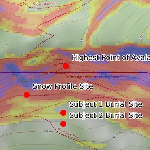
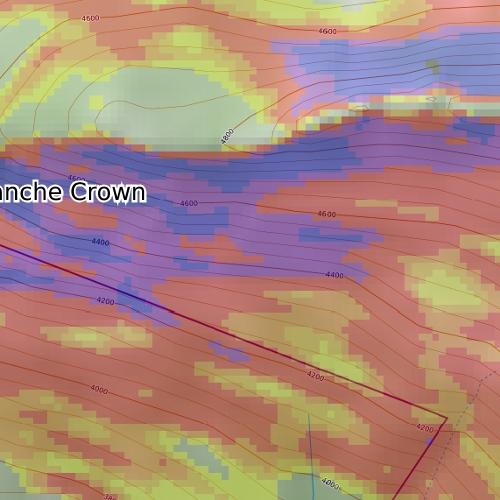
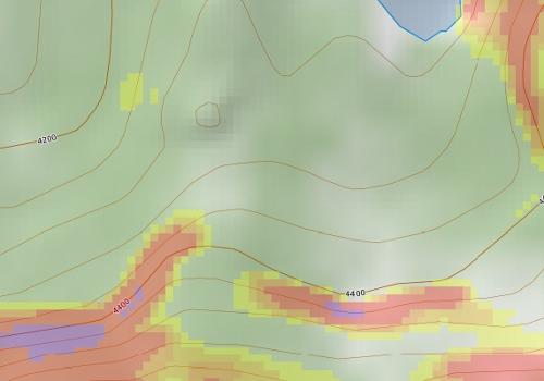
2 Avalanche Danger Rating (Below Treeline): High (Avalanche Warning for High Danger was in effect for all elevations in the Snoqualmie Pass Zone) Avalanche and Terrain The avalanche on Snow Lake Divide occurred on a South aspect at 4250 ft. The avalanche was observed to be wide relative to slope and to have fractured across complex terrain features. This was due to the combination of a hard bed surface and a persistent grain type capable of propagating a fracture wide distances. Rapid snowfall accumulation during the day likely overloaded the crust/pwl combination and the slope angle was sufficiently steep to produce a large avalanche. Debris measured in excess of 2 meters with snow flagging noted on the uphill sides of old growth trees 2 meters above the snow surface. The overall terrain can be characterized as a hanging valley headwall above a tight valley floor, with numerous small cliffs, steep convexities and gullies. The alpha angle from the highest crown to Subject 2 s burial location was 32 degrees. NWAC staff and the SAR teams were not able to determine if this was a natural or human-triggered avalanche due to lack of definitive surface clues. The avalanche was classified as SS-U-R3-D2.5-I. NWAC Professional Observer, Jeremy Allyn, and NWAC Education and Operations Manager, Forest McBrian arrived at the Alpental Ski Area upper parking lot at 1:30 pm on Monday, February 26 and were debriefed by the SAR Incident Commander and members of the SAR teams. They then traveled by skis to the incident site and conducted an avalanche investigation. After inspecting the burial locations, a snow profile site was chosen 100 feet adjacent to a lower section of crown on the avalanche s western flank at 4025 feet. Other overhead hazards, as well as residual hang fire from the main slab avalanche were identified and it was determined there was no safe way to ascend to the uppermost crown to conduct a crown profile. The slope for the snow profile was on a convex roll, 42 degrees, South aspect (see snow profile below). Notable snowpack test results were observed down 48 cm from the surface on a sun crust (1 cm thick) that had been buried by storm snow on February 23. The weak layer was observed to be 1 mm Facets (starting to round and sinter) with the sun crust acting as a bed surface. Some portions of the crown face were measured to be 85 cm, however, due to overhead hazard, most of the crown could not be directly measured. Snowpack and Weather Along the West Slopes of the Cascades including the Snoqualmie Pass area, a period of cold weather and intermittent light snowfall occurred in the week leading up to the avalanche incident with a stronger storm cycle beginning the weekend of Feb 24th-25th. Preceding the storm cycle, colder than normal temperatures allowed weak layers to develop in the upper snowpack. This included a persistent weak layer (near surface facets) that developed on top of a sun crust (melt-freeze), found on steep southerly aspects. This interface was buried by light snowfall on 2/23. Northwest Avalanche Center
3 While new snow and wind received on the 24th and especially on the 25th were more than enough to produce new storm snow avalanche hazards, the buried crust/pwl combination identified above was involved in both the Snow Lake Divide and the nearby Cottonwood Lake avalanche fatalities on Feb 25th. It s worth noting that numerous human triggered avalanches and seven fatalities were reported throughout the Cascades from late February through early March, releasing on some combination of a melt-freeze crust and facets. Accident Summary This was an unwitnessed incident. Through interviews with both sets of parents with a knowledge of text messages, NWAC believes Subjects 1 and 2 left the Alpental upper parking lot around 4 pm on February 25th. Their plan remains uncertain and appears to have been affected by competing and uncertain plans, directions from both sets of parents to avoid avalanche terrain, and the late hour of the day. Subject 2 brought alpine skis in addition to snowshoes. Those skis were left in their vehicle. Subject 1 had ski touring gear. Individually they both were aware of the day s avalanche forecast. Subject 1 was told of the avalanche danger verbally and via text. Subject 2 was shown the forecast on a computer prior to leaving home. Notably, Subject 2 had been on a snowshoe trip along the Snow Lake summer trail the day prior, February 24th. That trip was aborted due to difficult travel conditions and avalanche hazard concerns. Despite recent storm snow, the snowshoe track would have remained intact (albeit partially buried) on the 25th, as it was still visually evident as observed by NWAC and SAR teams the following day. Due to the location of the avalanche crown and the locations of the burials, it is NWAC s conclusion that the pair were caught and carried in an avalanche while in or below the final switchbacks of the Snow Lake trail. Rescue Summary At approximately 9:40 pm on February 25, Seattle Mountain Rescue (SMR) was alerted to 2 overdue backcountry travelers in the Source Lake area. They were reported to have been triangulated by cell phone GPS at a last known location of: N, W. Due to high avalanche danger and another avalanche involvement near Cottonwood Lake, the mission was put on standby for the following day. On February 26, 4 rescue teams comprised of SMR, King County Explorer Search and Rescue, and the Ski Patrol Avalanche Rescue Team (SPART) departed the Alpental base between 8:20-8:30 am. At approximately 9:30 am, SMR Team 1 reached the suspected avalanche location and immediately received 2 avalanche transceiver signal hits. A combination of transceiver searching, probing, and shoveling resulted in a confirmed probe strike and Subject 1 was located at: N, W, at 3,860 ft on a 28 deg slope uphill of a large tree. Burial depth was 1.5 meters. He was found with one ski attached to his backpack as well as an ice axe. SAR personnel found Subject 1's ski with a climbing skin affixed. He was not wearing a helmet. SPART Team 3 located Subject 2 at 9:37 am at: N, W, at 3820 ft on a 18 deg. slope near a stand of large trees. Burial depth was 2.2 meters. He was found wearing one Northwest Avalanche Center
4 snowshoe as well as an ABS avalanche airbag pack that was not deployed. He was wearing a helmet. At 10:11 am, snow surface instabilities were observed on scene, initiating as the result of solar effect and warming temperatures. One size D2 Wet Loose avalanche released naturally and ran within 100 feet to the west of the incident site. This activity forced all teams to pull back from Subject 1 to Subject 2 (lower in the terrain). After an on-scene safety briefing, more visual avalanche guards were assigned and the the numbers of SAR personnel were reduced to limited exposure to the overhead hazard. Subject 1 was evacuated from the scene at 10:36 am. SPART Team 3 (along with additional resources) completed the final extrication of Subject 2 at 12:16 pm after which all SAR personnel departed the scene arriving at Alpental base area at 1 pm. NOTE: All members of this SAR mission deserve special recognition. This was a dangerous scene to work in with very real elements of exposure and vulnerability due to ongoing avalanche activity. The SAR teams did an exemplary job in anticipating, recognizing, and managing the avalanche risk. Comments: Jeremy Allyn, NWAC Professional Observer Unwitnessed fatal avalanches are among the most difficult to comment upon. They pit our desire to know the facts and to educate directly against our frequent inability to understand the motivations and decision-making of the individuals directly involved. Without witnesses or other party members to interview, knowledge and understanding can remain elusive and tragedies even more difficult to comprehend. The fact that this particular slope has a history of producing large avalanches that have also killed people is significant. The slopes on, above, and adjacent to the summer trail leading to Snow Lake Divide are prime avalanche terrain. The same can be said for the other popular route to the Snow Lake Divide via terrain NW of Source Lake. Both routes involve significant overhead hazard and high levels of exposure and commitment. There is no avalanche safe route to the Snow Lake Divide. Avalanche slope history is important and repeat offenders like the slope that produced the fatal avalanche in this report should be taken very seriously relative to their history. Equally important is the history of recreational use in the Alpental Valley where this avalanche occurred. While awareness and use patterns have improved in recent years, the continued, almost daily use of the Snow Lake summer trail during the winter months (especially during periods of elevated avalanche danger) continues to be alarming. It is clear that both individuals in this incident had more than a passing understanding of the dangers of the route that ended up killing them. They also had knowledge of the most current avalanche forecast and were explicitly and specifically told by parents to avoid all avalanche terrain that afternoon. By all accounts these two young individuals were smart, cautious, and avalanche aware given their ages and experience. And yet, for reasons we will never know, they chose to attempt to Northwest Avalanche Center
5 climb to Snow Lake Divide on the afternoon of February 25. Perhaps a question that we as a community should be asking is not what were they thinking? but more along the lines of: Why do recreationists of all ages, walks of life, experiences, and modes of travel continue to follow the same route, through the same terrain, during periods of elevated avalanche danger? Northwest Avalanche Center

6 All Photographs were taken by Jeremy Allyn on February 26th, 2018 Avalanche crown from a distance Northwest Avalanche Center


7 Western crown and debris Western crown Northwest Avalanche Center


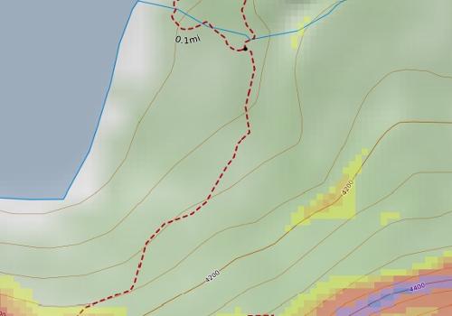
8 Looking uphill to the final set of switchbacks on Snow Lake Divide Summer Trail Trees in the runout Northwest Avalanche Center

9 Northwest Avalanche Center Burial site with rescuer gear for depth reference

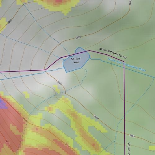

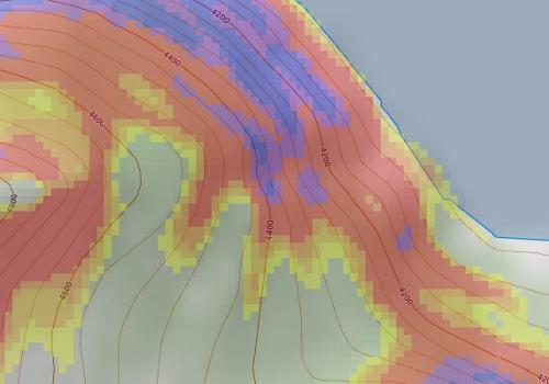
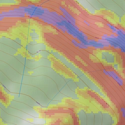
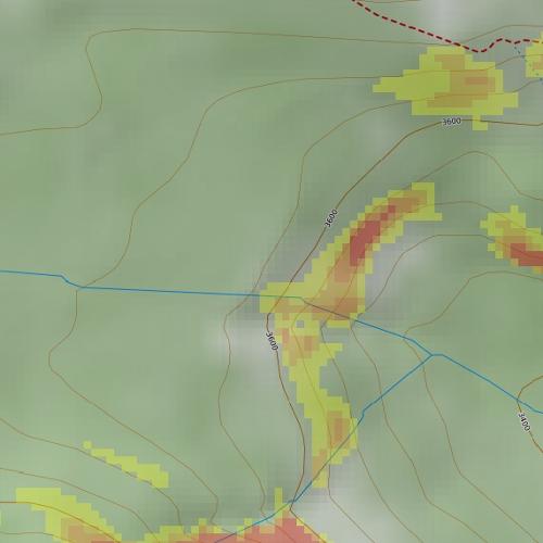
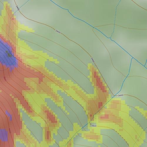
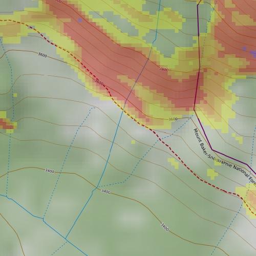
10 Slope Angle Shading:

11 Northwest Avalanche Center

12 Northwest Avalanche Center
13 Northwest Avalanche Center Snoqualmie Pass Precipitation and Wind Dir/Speed weather station data were used in lieu of Alpental stations that was unreliable during this event.


14 Snoqualmie Pass Issued: 6:55 PM PST Saturday, February 24, 2018 by Josh Hirshberg NWAC avalanche forecasts apply to backcountry avalanche terrain in the Olympics, Washington Cascades and Mt Hood area. These forecasts do not apply to developed ski areas, avalanche terrain affecting highways and higher terrain on the volcanic peaks above the Cascade crest level. The Bottom Line: Travel in avalanche terrain is not recommended as very dangerous avalanche conditions exist. Expect widespread avalanches big enough to bury or kill you. Only travel in the backcountry today if you are certain that you can avoid avalanche terrain. Elevation Sunday Outlook for Monday Above Treeline High Near Treeline High Below Treeline High Very dangerous avalanche conditions. Travel in avalanche terrain not recommended. Considerable Very dangerous avalanche conditions. Travel in avalanche terrain not recommended. Considerable Very dangerous avalanche conditions. Travel in avalanche terrain not recommended. Considerable Avalanche Problems for Sunday Wind Slab Wind slabs can take up to a week to stabilize. They are confined to lee and cross-loaded terrain features and can be avoided by sticking to sheltered or wind scoured areas. Avalanche Problem Aspect/Elevation Likelihood Size Storm Slabs Storm slabs usually stabilize within a few days, and release at or below the trigger point. They exist throughout the terrain, and can be avoided by waiting for the storm snow to stabilize. Avalanche Problem Aspect/Elevation Likelihood Size Persistent Deep Slab Deep, persistent slabs are destructive and deadly events that can take months to stabilize. You can triggered them from well down in the avalanche path, and after dozens of tracks have crossed the slope. Give yourself a wide safety buffer to handle the uncertainty, potentially for the remainder of the season. Avalanche Problem Aspect/Elevation Likelihood Size
15 Avalanche Forecast for Sunday Expect widespread avalanches in the new snow including many natural avalanches. Many of these could be big enough to kill you. The most dangerous areas will be steep slopes where new snow and wind have deposited 2 feet or more of cohesive snow since Friday. Select appropriate terrain to stay safe. Stay out of open slopes steeper than 35 degrees. Be aware of areas where avalanches commonly run. Avoid traveling below avalanche terrain and stay out of large avalanche paths. Only go into the backcountry today if you are sure of your ability to avoid avalanche terrain. With several overlapping avalanche problems this will be a challenging time to travel in the mountains. While Storm and Wind Slabs exist in the upper snowpack, very dangerous Deep Slabs lurk below. It s possible that avalanches in the upper snowpack could step down to deeper layers, triggering a very large and destructive avalanche. Deep Slab avalanches are very difficult to predict and give little warning sign. While they may be difficult to trigger your chances of surviving one are slim. If you dig 2-3 feet below the snow surface, you will find a thin layer of sugar-like facets adjacent to a hard crust. You can dig snowpits and use snowpack tests to confirm the strong over weak snow layers of the Deep Slab avalanche problem. Your best way to stay safe from these avalanches is to avoid triggering avalanches in the upper snowpack. Excellent travel conditions can still be found on slopes less than 30 degrees that are not connected to steep overhead slopes. Avalanche Summary Heavy snowfall and strong winds have elevated avalanche danger, once again. Up to 1.5 feet of snow accumulated across the West Slopes by Saturday evening. Another 1-2 feet of snow will fall with strong winds by late Sunday. Snowfall starting at the end of the work week fell on a variety of surfaces including old snowflakes, surface hoar, and possibly some small facets. Widespread natural avalanches were reported from the Mt Baker and Snoqualmie pass areas on Saturday. These were soft slab avalanches and some loose avalanches in the recent snow feet deep with a few reported as big enough to bury a person. Some of these avalanches ran within the new snow while other slid on the interfce of new and old snow. Observers have not consistently found problematic weak layers at the February 23rd interface. Last weekend, observers reported a widespread cycle of large to very large avalanches occurring with a potent storm. Avalanches ran in the storm snow as well as on facets, buried on the 13th of February. In many locations these weak sugar-like facets sit 3 feet below the surface on or adjacent to a hard crust layer. Avalanches, collapses, and whumphs have been triggered on this persistent weak layer well after last weekend s initial avalanche cycle. Snowpack test and observations from around the region continue to demonstrate that this layer can fail and produce avalanches. Tests and profiles show the most consistent results from the Stevens and Snoqualmie pass areas. In the Mount Baker area the weak layer is more intermittent and can often show up as facets around a series of crusts. A thin rain crust formed and was buried on 2/17 near and below 4000 in the Snoqualmie area. Limited information about this snowpack layer has been reported other than it is ski-supportable. Below the 2/8 crust there are no significant layers of concern. Observations Stevens and Snoqualmie Pass On Saturday, Alpental Patrol reported that slab avalanches were easily triggered in the recent snow with ski cuts during control work. An NWAC observer reported many similar natural avalanches in the adjacent backountry at Snoqualmie Pass. Also on Saturday, NWAC staff reported two different locations near Snoqualmie pass. While the 2/13 facet layer is showing rounding, test results indicated that the potential for triggering an avalanche still exists. This supports numerous similar snowpack tests results Stevens and Snoqualmie passes, the Crystal and Mt Rainier backcountry and to some extent the Mt Baker backcountry all conducted over the last week. On Tuesday NWAC staff traveled through popular backcountry terrain near the Skyline area of Stevens Pass, finding the 2/13 facets on most slopes. The most recent Persistent Slab avalanche was triggered on Monday at Stevens Pass backcountry (Stevens Pass-Hollywood Bowl-2-19). It failed on facets just above the 2/5 crust. South On Friday NPS rangers in the Paradise area reported 3-4 feet of snow over weak facets. No wind transported snow was observed. NWAC Forecaster Dallas Glass observed a large audible whumph caused by a collapsing weak layer Tuesday near Paradise. Snowpack tests in the area indicated the persistent weak layer could fail and produce avalanches up to 4 feet deep. No recent observations have been received from the Crystal backcountry. A higher level of uncertainty exists in this area. Mountain Weather Synopsis for Sunday & Monday A 100+ kt westerly jet stream core centered on the WA coast early Sunday morning added a solid punch to a trough moving across the region and the associated frontal moisture Sunday. The strong westerly flow aloft translated down to crest level and combined with heavy precipitation rates to create stormy conditions throughout the forecast region Sunday. This pattern has caused several post frontal or convergence bands of heavier showers to form Sunday afternoon. Most of the heavier shower activity has been targeted to the Stevens Pass area, but certainly not limited to. The flow and subsequent showers should diminish rapidly overnight with convergence bands dissipating. Freezing levels have been lowering since an early morning shallow warm up. The trough will
16 continue to dig southward as high pressure rebuilds over the eastern North Pacific Sunday night. This should allow for further diminishing flow becoming more northwesterly and gradually drying causing diminishing showers overnight Sunday. By Monday the trough along the west coast digs southward to central California while the offshore high pressure ridge gains strength. This should cause a weakening NW flow, maintaining cool temperatures and a few scattered light snow showers Monday, mainly along the west slope areas, along with partial clearing at times. 24 Hour Quantitative Precipitation ending at 4 am Snow Level/Freezing Level in feet Location Mon Tue Hurricane Ridge 1.00 lt.10 Mt Baker Ski Area lt.10 Washington Pass.50 lt.10 Stevens Pass 1.50 lt.10 Snoqualmie Pass lt.10 Mission Ridge Crystal Mt.75 lt.10 Paradise lt.10 White Pass lt.10 Mt Hood Meadows 2.00 lt.10 Timberline 2.00 lt.10 LT = less than; WE or Water equivalent is the liquid water equivalent of melted snow in hundredths of inches. As a rough approximation 1 inch of snow = about.10 inches WE, or 10 inches of snow = about 1 inch WE. Day Olympics Northwest Northeast Cascades Cascades Central Cascades South Cascades Sunday Morning 2000' 1000' 1000' 2000' 2500' Sunday Evening 1000' 500' 500' 1000' 2000' Sunday Night 500' 0' 0' 500' 1000' Monday Morning 500' 0' 0' 500' 500' Monday Afternoon 1500' 1000' 1000' 1500' 2000' Monday Night 1000' 500' 500' 1000' 1000' Easterly Flow in Passes Cascade Snow / Freezing Levels noted above refer to the north (approximately Mt Baker and Washington Pass), central (approximately Stevens to White Pass) and south (near Mt Hood). Freezing Level is when no precipitation is forecast. * Note that surface snow levels are common near the passes during easterly pass flow and may result in multiple snow / freezing levels. USE AT YOUR OWN RISK This Backcountry Avalanche Forecast is provided in conjunction with the US Forest Service, and is intended for personal and recreational purposes only. Safe backcountry travel requires preparation and planning, and this information may be used for planning purposes but does not provide all the information necessary for backcountry travel. Advanced avalanche education is strongly encouraged. The user acknowledges that it is impossible to accurately predict natural events such as avalanches in every instance, and the accuracy or reliability of the data provided here is not guaranteed in any way. This forecast describes general avalanche conditions and local variations will always occur. This forecast expires 24 hours after the posted time unless noted otherwise.
 Size: R3 \ D 2.")

 N/AV 2.")
17 American Avalanche Association Forest Service National Avalanche Center Avalanche Incident Report: Short Form Occurrence Date (YYYYMMDD): Time (HHMM):est pm Comments: Reporting Party Name and Address: Northwest Avalanche Center, 7600 Sandpoint Way NE, Seattle, WA Avalanche Characteristics: Type: SS Aspect: S Trigger: U Slope Angle: 40 (avg, est) Size: R3 \ D 2.5 Elevation: 4250 m / X ft Sliding surface (check one): In new X New/old In o ld G ro und Location: State: WA County: King Forest: Mt. Baker-Snoqualmie NF Peak, Mtn Pass, or Drainage: S Fork Snoqualmie R., Alpental Valley Site Name: Snow Lake Divide Trail Lat/Lon or UTM: N, W (upper burial location) Group Number of People Caught 2 Partially Buried Not critical Partially Buried-- Critical Completel y Buried Time recovered Duration of burial Depth to Face X m / ft m (#1) N/AV 2.2 m (#2) Number of people injured: Number of people killed: 2 Dimensions X m / ft Height of Crown Face Width of Fracture Vertical Fall Average 107 m (est) 152 m (est) Maximum 1 m (est) Snow Hardness Grain Type Grain Size (mm) Slab 4F-1F PP 1mm Weak F FCxr 1mm Layer Bed Surface P MFcr 1cm thick Thickness of weak layer: 0.3mm m m / cm / in Burial involved a terrain trap? no X yes typ e: Trees Number of people that crossed start zone before the avalanche: 2 Location of group in relation to start zone during avalanche: hig h m id d le lo w b elo w all X u n kno w n Avalanche occurred during X ascent descent Subject Name Age Gender Address Phone Activity 1 SUBJECT 1 18 M Ski 2 SUBJECT 2 17 M Snowshoe Equipment Carried X X Transceiver X X Shovel X X Probe Experience at Activity X X Unknown Novice Intermediate Advanced 1 Avalanche Training Unknown None X X Some Advanced
18 Expert Expert Signs of Instability Noted by Group X Unknown N one R ecent avalanches Shooting cracks C ollapse or w hum phing L o w test scores Injuries Sustained None First Aid Doctor s care Hospital Stay X X Fatal Extent of Injuries or Cause of Death X X Asphyxiation X Head Trauma Spinal Injury Chest Trauma Skeletal Fractures Other: Damage Number of Vehicles Caught: Number Structures Destroyed: Estimated Loss: $ Accident Summary Include: events leading to accident, group s familiarity with location, objectives, route, hazard evaluation, etc. This was an unwitnessed incident. Through interviews with both sets of parents with a knowledge of text messages, NWAC believes Subjects 1 and 2 left the Alpental upper parking lot around 4 pm on February 25th. Their plan remains uncertain and appears to have been affected by competing and uncertain plans, directions from both sets of parents to avoid avalanche terrain, and the late hour of the day. Subject 2 brought alpine skis in addition to snowshoes. Those skis were left in their vehicle. Subject 1 had ski touring gear. Individually they both were aware of the day s avalanche forecast. Subject 1 was told of the avalanche danger verbally and via text. Subject 2 was shown the forecast on a computer prior to leaving home. Notably, Subject 2 had been on a snowshoe trip along the Snow Lake summer trail the day prior, February 24th. That trip was aborted due to difficult travel conditions and avalanche hazard concerns. Despite recent storm snow, the snowshoe track would have remained intact (albeit partially buried) on the 25th, as it was still visually evident as observed by NWAC and SAR teams the following day. Due to the location of the avalanche crown and the locations of the burials, it is NWAC s conclusion that the pair were caught and carried in an avalanche while in or below the final switchbacks of the Snow Lake trail. Rescue Summary Include: description of initial search, report of accident, organized rescue, etc. At approximately 9:40 pm on February 25, Seattle Mountain Rescue (SMR) was alerted to 2 overdue backcountry travelers in the Source Lake area. They were reported to have been triangulated by cell phone GPS at a last known location of: N, W. Due to high avalanche danger and another avalanche involvement near Cottonwood Lake, the mission was put on standby for the following day. On February 26, 4 rescue teams comprised of SMR, King County Explorer Search and Rescue, and the Ski Patrol Avalanche Rescue Team (SPART) departed the Alpental base between 8:20-8:30 am. At approximately 9:30 am, SMR Team 1 reached the suspected avalanche location and immediately received 2 avalanche transceiver signal hits. A combination of transceiver searching, probing, and shoveling resulted in a confirmed probe strike and Subject 1 was located at: N, W, at 3,860 ft on a 28 deg slope uphill of a large tree. Burial depth was 1.5 meters. He was found with one ski attached to his backpack as well as an ice axe. SAR personnel found Subject 1's ski with a climbing skin affixed. He was not wearing a helmet. Rescue Method Self rescue X X Transceiver Spot probe Probe line Rescue dog Voice Object X X Digging Other: SPART Team 3 located Subject 2 at 9:37 am at: N, W, at 3820 ft on a 18 deg. slope near a stand of large trees. Burial depth was 2.2 meters. He was found wearing one snowshoe as well as an ABS avalanche airbag pack that was not deployed. He was wearing a helmet. At 10:11 am, snow surface instabilities were observed on scene, initiating as the result of solar effect and warming temperatures. One size D2 Wet Loose avalanche released naturally and ran within 100 feet to the west of the incident site. This activity forced all teams to pull back from Subject 1 to Subject 2 (lower in the terrain). After an on-scene safety briefing, more visual avalanche guards were assigned and the the numbers of SAR personnel were reduced to limited exposure to the overhead hazard. 2
19 Subject 1 was evacuated from the scene at 10:36 am. SPART Team 3 (along with additional resources) completed the final extrication of Subject 2 at 12:16 pm after which all SAR personnel departed the scene arriving at Alpental base area at 1 pm. Attach additional pages as needed. Include weather history, snow profiles, reports from other agencies, diagram of site, photographs, and any other supporting information Please send to: CAIC; 325 Broadway WS1; Boulder CO 80305; caic@state.co.us and to the nearest Avalanche Center. 3
Cottonwood Lake Avalanche Fatality February, 25th 2018
 Cottonwood Lake Avalanche Fatality February, 25th 2018 Report by Josh Hirshberg and Dennis D Amico, Northwest Avalanche Center Incident snapshot Occurrence Time and Date: Approximately 12:00pm Feb 25,
American Avalanche Association Forest Service National Avalanche Center Avalanche Incident Report: Long Form
 American Avalanche Association Forest Service National Avalanche Center Avalanche Incident Report: Long Form Please send to: CAIC; 325 Broadway WS1; Boulder CO 80305; caic@qwest.net; Fax (303) 499-9618
American Avalanche Association Forest Service National Avalanche Center Avalanche Incident Report: Short Form
 American Avalanche Association Forest Service National Avalanche Center Avalanche Incident Report: Short Form Occurrence Date (YYYYMMDD): 20170205 and Time (HHMM): 1100 Comments: Most avalanche characterists
Park Butte Avalanche Fatality March 10 th, 2018
 Park Butte Avalanche Fatality March 10 th, 2018 Report by Lee Lazzara and Dennis D Amico, Northwest Avalanche Center Recovery details provided by Whatcom County Sheriff s Office Incident snapshot Occurrence
Morning Star Peak Avalanche Accident
 Morning Star Peak Avalanche Accident Saturday, December 4, 2010 Date: 2010-12-13 Submitted by: Oyvind Henningsen Everett Mountain Rescue and Mark Moore NWAC Place: Morning Star Peak, north-central WA Cascades
Corona Bowl Avalanche Incident, December 6th, 2015
 Corona Bowl Avalanche Incident, December 6th, 2015 Report prepared by NWAC and Stevens Pass Pro Patrol Incident snapshot Time and Date: 11:48 AM, December 6 th, 2015 Location: Corona Bowl, Chief Mountain,
Avalanche Mountain Incident March 4 th, 2017
 Avalanche Mountain Incident March 4 th, 2017 Report by Dennis D Amico, Robert Hahn and Jeremy Allyn Incident snapshot Occurrence Time and Date: Approximately 3 pm on March 4th, 2017 Time First Reported
Excelsior Pass Avalanche Accident January 1, 2008
 Excelsior Pass Avalanche Accident January 1, 2008 Accident Summary Time: 1 January 2008, approximately 13:00 hrs Location: Near Excelsior Pass to east of Church Mt, Northern Washington Cascades WA Activity:
Avalanche danger high in parts of NCW
 3/23/2017 Avalanche danger high in parts of NCW THURSDAY, MARCH 23, 2017 Avalanche danger high in parts of NCW by Christine Pratt Public Safety Feb. 9, 2017, 4:52 p.m. Photo provided An avalanche hit the
SYNOPSIS WEATHER AND SNOWPACK
 Peak 6996 Avalanche Fatality Incident Report Glacier National Park, MT Date of Avalanche: 31 March 2010 Date of Investigation: 2 April 2010 Investigation Team: Erich Peitzsch (USGS), Ted Steiner (Chugach
Twin Lakes Avalanche Incident 1/31/2016
 Twin Lakes Avalanche Incident 1/31/2016 Location: Place State Published by: Dave Bingaman (PAC), George Halcom (PAC), and Kent May (PAC) Twin Lakes, Salmon River Mountains Idaho Date 01/31/2016 Time Summary
Typical avalanche problems
 Typical avalanche problems The European Avalanche Warning Services (EAWS) describes five typical avalanche problems or situations as they occur in avalanche terrain. The Utah Avalanche Center (UAC) has
Granite Mountain Avalanche Fatality, December 31st, 2015 Report prepared by NWAC
 Granite Mountain Avalanche Fatality, December 31st, 2015 Report prepared by NWAC Incident snapshot (All avalanche fields estimated from interview with Seattle Mountain Rescue) Time and Date: Mid-day or
Henderson Mountain Avalanche Accident Two riders caught, one partially buried, one fully buried
 Henderson Mountain Avalanche Accident Two riders caught, one partially buried, one fully buried Custer-Gallatin National Forest 28 November 2014 Synopsis A group of 6 or 7 snowmobilers (part of a larger
Slot Couloir Accident, Snoqualmie Mt
 Body Page 1 Slot Couloir Accident, Snoqualmie Mt 4-27-14 Date and Time: estimated 12 pm, Sunday 4/27/14 Location: Slot Couloir, Snoqualmie Mt Number in Party: 2 backcountry skiers Number hurt: 1 backcountry
Avalanche Awareness and Leading a Companion Rescue
 Avalanche Awareness and Leading a Companion Rescue Introduction: Traveling in the backcountry is a great way to enjoy the outdoors and friends. It s important that when we travel in the backcountry we
Number Caught: 2 Partially Buried, Non-Critical: 1 Partially Buried, Critical: 0 Fully Buried: 1 Injured: 1 Killed: 1
 South Waldron Creek Avalanche Fatality 2 snowmobilers caught, 1 carried and injured, 1 fully buried and killed. Teton River, MT Helena-Lewis and Clark National Forest January 5 th, 2019 Avalanche Details
Lane Peak, Fly Couloir Avalanche 2/25/2017
 Lane Peak, Fly Couloir Avalanche 2/25/2017 NWAC Report by Jeremy Allyn and Dennis D Amico Incident snapshot: Occurrence Time and Date: 1234 pm, February 25, 2017 Lat/Lon: 46.7581, -121.7531 (estimated,
Swede Creek Avalanche Incident Report Swede Creek, Whitefish Range, MT Date of Avalanche: 23 January 2016 Date of Site Visit: 24 January 2016
 Swede Creek Avalanche Incident Report Swede Creek, Whitefish Range, MT Date of Avalanche: 23 January 2016 Date of Site Visit: 24 January 2016 INCIDENT SYNOPSIS On Saturday, January 23, 2016, three snowmobilers
Part 1: Introduction to Decision Making
 Part 1: Introduction to Decision Making 1.1 - Anatomy of a Decision ABOUT AIARE Learning Outcomes Identify that backcountry decision making involves five key components: Plan, Observe, Teamwork, Choose
Avalanche Accident Report
 Hatcher Pass Avalanche Center POB 1223 Chickaloon, AK 99674 907-746-4566 info@hatcherpassavalanchecenter.org Avalanche Accident Report January 2, 2016 Avalanche Accident in Grubstake Gulch, Talkeetna Mountains,
Proceedings, International Snow Science Workshop, Breckenridge, Colorado, 2016
 AVALANCHE FORECASTING AND MESSAGING FOR UNUSUAL AVALANCHE CONDITIONS IN A MARITIME SNOW CLIMATE-BURIED SURFACE HOAR INTERNATIONAL SNOW SCIENCE WORKSHOP 2016 IN BRECKENRIDGE, CO Steve A. Reynaud Sierra
International Snow Science Workshop
 A PRACTICAL USE OF HISTORIC DATA TO MITIGATE WORKER EXPOSURE TO AVALANCHE HAZARD Jake Elkins Jackson Hole Mountain Resort, Teton Village, Wyoming Bob Comey* Jackson Hole Mountain Resort, Teton Village,
Twin Peaks Near Miss Report Turnagain Pass, Kenai Mountains, Alaska
 Twin Peaks Near Miss Report Turnagain Pass, Kenai Mountains, Alaska Location: East Face, Twin Peaks Lat/Lon: 60.71343N, -149.38205E Date: February 3, 2018, Time: 3:50 pm Report by: Chugach National Forest
2/16/2014 Idaho Frenchman Creek Published by Scott Savage, SAC
 Location: Place Frenchman Creek drainage, Smoky Mountains State Idaho Date 2/16/2014 Time 2:00pm Summary 4 snowmobilers buried, 1 killed, 1 injured Number: Caught 4 Fully Buried 4 Injured 1 Killed 1 Avalanche
Avalanche Safety Guidelines
 Introduction Avalanche Safety Guidelines Worldwide, avalanches kill more than 150 people annually and thousands more are partly buried or injured. Although highway motorists and others can be involved
Crystal Mountain Snow Safety Union Creek Avalanche Accident Report December 2, 2007
 Crystal Mountain Snow Safety Union Creek Avalanche Accident Report December 2, 2007 Prepared by Paul Baugher, Chris Morin, Crystal Mt Ski Patrol/ Snow Safety and Mark Moore, NWAC Accident Summary Time:
Avalanche Safety Guidelines This guideline is intended as a general introduction to this topic.
 Introduction Worldwide, avalanches kill more than 150 people annually and thousands more are partly buried or injured. Although highway motorists and others can be involved in an avalanche, climbers, backcountry
NWAC Blog. Cornices - don't walk the line! Written by Robert Hahn on March 14, Last update on May 15, 2017.
 NWAC Blog Cornices - don't walk the line! Written by Robert Hahn on March 14, 2017. Last update on May 15, 2017. Human-triggered cornice fall avalanche from March 10th, 2017. The crown release exposed
Proceedings, International Snow Science Workshop, Breckenridge, Colorado, 2016 ANALYSIS OF UTAH AVALANCHE FATALITIES IN THE MODERN ERA
 ANALYSIS OF UTAH AVALANCHE FATALITIES IN THE MODERN ERA Drew Hardesty 1 * 1 Utah Avalanche Center ABSTRACT: The Utah Avalanche Center (UAC) has records of Utah avalanche fatalities for the modern era,
Twin Wildcat Lakes Avalanche Wednesday, February 1, 2012 Incident Report
 Twin Wildcat Lakes Avalanche Wednesday, February 1, 2012 Incident Report February 17, 2012 Location: (See Appendix A-1 Maps) Hungry Horse Ranger District Flathead National Forest -Region One Flathead County
Washington Explorer Search and Rescue Pierce County Unit February 2013
 Washington Explorer Search and Rescue Pierce County Unit February 2013 Part I Winter Training Logistics Gear for Winter Training Building Snow Caves & Other Snow Shelters Winter Training Logistics - 2013
Avalanche accident case study: Persistent buried weak layer in the Central Idaho Mountains
 Avalanche accident case study: Persistent buried weak layer in the Central Idaho Mountains Doug Abromeit* Forest Service National Avalanche Center Bozo Cardozo Sun Valley Helicopter Ski Guides Ketchum,
Elevation Bands Description of terrain characteristics to which the avalanche danger ratings apply.
 1 Definition of Terms used in Daily Trip Forms This document is part of Decision Making in Avalanche Terrain: a fieldbook for winter backcountry users by Pascal Haegeli, Roger Atkins and Karl Klassen and
Self-Guided Group Organization - Recommendations
 Self-Guided Group Organization - Recommendations Introduction The purpose of this document is to offer a template to self-guided groups with respect to pre-trip and on-trip planning. The ultimate goal
ENVIRONMENTAL HAZARDS OF AVALANCHES: PRELIMINARY RESEARCH IN GLACIER NATIONAL PARK
 ENVIRONMENTAL HAZARDS OF AVALANCHES: PRELIMINARY RESEARCH IN GLACIER NATIONAL PARK Site Focus: Balu Pass, Glacier National Park, B.C. Avalanche path near Balu Pass. (Photo Courtesy of: www.leelau.net/2007/rogerspass/day1/1)
The Kendall Trap. Charlie Hagedorn
 This photo-essay is neither a route-description nor a guide; it is intended to raise, among skiers already familiar with the area, awareness of hazards, to suggest not doing something. Take accredited
NivoTest : a personal assistant for avalanche risk assessment
 NivoTest : a personal assistant for avalanche risk assessment R.Bolognesi METEISK, CP 993, CH-1951 SION. www.meteorisk.com Introduction About avalanche risk Every mountaineer knows that avalanche hazard
Scottish Mountain Rescue Avalanche Burial Organised Rescue Response SCOTTISH MOUNTAIN RESCUE AVALANCHE BURIAL - ORGANISED RESCUE RESPONSE
 Scottish Mountain Rescue Avalanche Burial Organised Rescue Response SCOTTISH MOUNTAIN RESCUE AVALANCHE BURIAL - ORGANISED RESCUE RESPONSE The International Commission for Alpine Rescue (ICAR) recommends
2010 International Snow Science Workshop
 200 International Snow Science Workshop TEN YEARS OF AVALANCHE DEATHS IN THE UNITED STATES, 999/00 TO 2008/09 Dale Atkins* RECCO AB ABSTRACT: After reaching a twenty-year low in the late 980s avalanche
In southern Upper Valais a very high avalanche danger will be encountered in some regions Edition: , 08:00 / Next update: 9.1.
 Page 1/6 In southern Upper Valais a very high avalanche danger will be encountered in some regions Edition: 9.1.2018, 08:00 / Next update: 9.1.2018, 17:00 Avalanche danger updated on 9.1.2018, 08:00 region
Ski / Sled tracks as an expression of avalanche risk Jordy Hendrikx 1 & Jerry Johnson 2,1 1.
 Ski / Sled tracks as an expression of avalanche risk Jordy Hendrikx 1 & Jerry Johnson 2,1 1 Snow and Avalanche Laboratory, Montana State University, Bozeman, Montana, USA 2 Political Science, Montana State
International Snow Science Workshop
 Chinook Pass: 25 Years On John Stimberis*, Washington State Department of Transportation, Snoqualmie Pass, Washington, USA ABSTRACT: Washington State Route 410 over Chinook Pass (1656 m) is generally closed
Avalanches and the Mount Whitney Basin
 Avalanches and the Mount Whitney Basin 10 April 2006 by Bob Rockwell Prelude Avalanches are a fact of life in high mountains in winter, and we take courses to find out about them. We learn how to assess
Avalanche Observations
 Avalanche Observations Avalanche Observations 3.1 Introduction Observations of past and present avalanche activity are of the utmost importance for any avalanche forecasting operation. These data should
AVALANCHE TERRAIN. Bill Glude Alaska Avalanche Specialists All photos and graphics Bill Glude unless otherwise noted.
 Bill Glude Alaska Avalanche Specialists 20111202 All photos and graphics Bill Glude unless otherwise noted. AVALANCHE TERRAIN The Key Questions 1.) Could the terrain produce an avalanche?! a.) Where you
Example of the layout of a Fieldwork Atlas
 Example of the layout of a Fieldwork Atlas Example of a Worksite with multiple facilities and work goals in one area: Map Center 49 3 46 N 117 3 11 W Noname Area with typical travel route marked. Avalanche
New Motorized Level I Avalanche Class!
 New Motorized Level I Avalanche Class! New guidelines by American Avalanche Association. Fast paced 24 hour class with minimum of 60% of hours on snow. This is a snowmobile/snow bike specific class and
THRESHOLD GUIDELINES FOR AVALANCHE SAFETY MEASURES
 BRITISH COLUMBIA MINISTRY OF TRANSPORTATION & INFRASTRUCTURE AVALANCHE & WEATHER PROGRAMS THRESHOLD GUIDELINES FOR AVALANCHE SAFETY MEASURES British Columbia Ministry of Transportation & Infrastructure
MP : the top of the bottom switchback
 MP 237 238: the top of the bottom switchback For reference this section of U S Highway 40 has been called the top of the bottom switchback on the Grand County side of the Pass. It is here that the proposed
Proceedings, International Snow Science Workshop, Banff, 2014
 TRAVEL ADVICE FOR THE AVALANCHE PROBLEMS: A PUBLIC FORECASTING TOOL Wendy Wagner 1 * and Drew Hardesty 2 1 Chugach National Forest Avalanche Center, Girdwood, Alaska 2 Utah Avalanche Center, Salt Lake
Resource Typing Template
 Resource Typing Template Resource: Mountain Search and Rescue Categories: Transportation (ESF 1) Communication (ESF 2) Public Works and Engineering (ESF 3) Firefighting (ESF 4) Information & Planning (ESF
Proceedings, 2012 International Snow Science Workshop, Anchorage, Alaska
 I-90 SNOQUALMIE PASS: OPERATING A HIGHWAY AVALANCHE PROGRAM DURING A MAJOR CONSTRUCTION PROJECT John Stimberis, Washington State Department of Transportation ABSTRACT: Snoqualmie Pass, WA (921m) receives
Scenario #1 - GROUND SEARCH
 Scenario #1 - GROUND SEARCH An elderly male dementia patient has walked away from a residence in a rural area. He has done this before. It is now 1900hrs. He has been missing for four hours and needs medication.
Report from Marcel Meier Dog-handler sub-commission regarding the dog-handler gathering that be held by Marcel last winter.
 Avalanche commission report Killarney Ireland 2015 Oct. Practical day : Presence of the President of the avalanche commission. Assembly of Delegates of the Avalanche Rescue Commission: Welcome / Meeting
Alaska Avalanche Information Center (AAIC) Season Summary Statewide AAIC Outreach Stats: ANCHORAGE (AAC)
 Season Summary Statewide AAIC Outreach Stats: ANCHORAGE (AAC)") Alaska Avalanche Information Center (AAIC) 2015-16 Season Summary Alaska experienced another unseasonably warm winter with heightened avalanche activity across many parts of the state in late November
Alaska Avalanche Information Center (AAIC) 2015-16 Season Summary Alaska experienced another unseasonably warm winter with heightened avalanche activity across many parts of the state in late November
Going-to-the-Sun Road, Glacier National Park, MT, USA Avalanche Path Atlas
 Going-to-the-Sun Road, Glacier National Park, MT, USA Avalanche Path Atlas Erich H. Peitzsch Daniel B. Fagre USGS Northern Rocky Mountain Science Center West Glacier, MT, USA Introduction... 2 Overview
Proceedings, 2012 International Snow Science Workshop, Anchorage, Alaska
 HISTORICAL ANALYSIS OF AVALANCHE FATALITIES IN DENALI NATIONAL PARK Kevin Wright 1,2 and Tucker Chenoweth 1,3 1 Denali National Park Mountaineering Program, Talkeetna, AK, USA 2 Chugach National Forest
Jill Hawk Chief Ranger, Mount Rainier National Park Tahoma Woods, Star Route Ashford, WA 98304
 January 21, 2003 Jill Hawk Chief Ranger, Mount Rainier National Park Tahoma Woods, Star Route Ashford, WA 98304 Re: Analysis of the Mount Rainier Climbing Program; Proposal to Increase Special Fee Dear
Risk Management Plan
 Risk Management Plan Revised June 14, 2011 by Bela G. Vadasz Technical Director Alpine Skills International 11400 Donner Pass Rd. Truckee, CA 96161 (530) 582-9170 w w w. a l p i n e s k i l l s. c o m
Avalanche Safety Basics By Sandy K. Ott
 Avalanche Safety Basics By Sandy K. Ott For Mountain Riders, or Those Going Into the Mountains to Ride There is one common theme when the avalanche experts go investigate avy incidents. The responses they
AVALANCHE FLOTATION DEVICES
 AVALANCHE FLOTATION DEVICES 1. ISSUE In the Coroner s Report into the deaths of Ms. Kimberly Anne Manchip and Mr. Daisuke Matsui, both of whom were caught in an avalanche and died from asphyxiation, the
THE SME AVALANCHE TRAGEDY OF JANUARY 20, 2003: A SUMMARY OF THE DATA. Dick Penniman* Snowbridge Associates Frank Baumann Baumann Engineering
 THE SME AVALANCHE TRAGEDY OF JANUARY 20, 2003: A SUMMARY OF THE DATA Dick Penniman* Snowbridge Associates Frank Baumann Baumann Engineering ABSTRACT: On January 20, 2003 guided skiers and snowboarders
AVALANCHE INSTRUCTOR S MANUAL TAB: TEST BANK CHAPTER 9. UPDATED VERSION AVALANCHE TEST BANK (without answers) January 1999
 January 1999") AVALANCHE INSTRUCTOR S MANUAL TAB: TEST BANK CHAPTER 9 UPDATED VERSION AVALANCHE TEST BANK (without answers) January 1999 This document replaces the October 1995 version in Chapter 9 of your Avalanche
AVALANCHE INSTRUCTOR S MANUAL TAB: TEST BANK CHAPTER 9 UPDATED VERSION AVALANCHE TEST BANK (without answers) January 1999 This document replaces the October 1995 version in Chapter 9 of your Avalanche
International Snow Science Workshop
 IMPROVING K-9 AVALANCHE TEAM PERFORMANCE AND COMMUNICATION IN BACKCOUNTRY AVALANCHE MISSIONS: A COLLABORATIVE APPROACH BETWEEN SKI PATROL AND K-9 SEARCH AND RESCUE (SAR) TEAMS Susan Purvis *1 Patti Burnett
Oregon Region Report from the Oregon Mountain Rescue Council
 Oregon Region Report from the Oregon Mountain Rescue Council More current information can be found on each team s web site or at the Oregon Mountain Rescue Council s web site at http://corvallismountainrescue.org/omrc/
FRANCE : HOW TO IMPROVE THE AVALANCHE KNOWLEDGE OF MOUNTAIN GUIDES? THE ANSWER OF THE FRENCH MOUNTAIN GUIDES ASSOCIATION. Alain Duclos 1 TRANSMONTAGNE
 FRANCE : HOW TO IMPROVE THE AVALANCHE KNOWLEDGE OF MOUNTAIN GUIDES? THE ANSWER OF THE FRENCH MOUNTAIN GUIDES ASSOCIATION ABSTRACT : Alain Duclos 1 TRANSMONTAGNE Claude Rey 2 SNGM The French Mountain Guides
Introduction to Safety on Glaciers in Svalbard
 Introduction to Safety on Glaciers in Svalbard Content Basic info on Svalbard glaciers Risk aspects when travelling on glaciers Safe travel on glaciers UNIS safety & rescue equipment Companion rescue in
AVALANCHE SKILLS TRAINING 1 MOUNT CAIN
 Thank you for choosing Island Alpine Guides for your Avalanche Skills Training. This package contains some background information to help you prepare, including meeting times and places, and a complete
Skyland Avalanche Saturday, February 25, 2012 Incident Report
 Skyland Avalanche Saturday, February 25, 2012 Incident Report April 12, 2012 Location: (See Appendix A-1 Maps) Hungry Horse Ranger District Flathead National Forest - Region One Flathead County, Montana
Mountain Rescue Council England & Wales. Incident Report 2003
 Mountain Rescue Council Charity No. Mountain Rescue Council & Incident Report Copyright Mountain Rescue Council (First Revision -Jun-) All enquiries please direct to: - Ged Feeney MRC Statistics Officer
Course Information. Required Text: AIARE Student Manual. (Instructor will provide on Day 1 of the course)
") Red Rocks Community College Spring 2017 Outdoor Studies OUT 168 Avalanche Awareness I Course Information Instructor: John MacKinnon, Outdoor Education- Adjunct Faculty Cell # 970 236 6130 Email: john.mackinnon@rrcc.edu
Red Rocks Community College Spring 2017 Outdoor Studies OUT 168 Avalanche Awareness I Course Information Instructor: John MacKinnon, Outdoor Education- Adjunct Faculty Cell # 970 236 6130 Email: john.mackinnon@rrcc.edu
2.08 AVALANCHE SEARCH AND RESCUE. Q: What is the process to provide feedback on the Interim Policy and Avalanche Safety Plan?
 2.08.1 RELATED DOCUMENTS 2.08 Avalanche Search and Rescue Policy 2.08 AVALANCHE SEARCH AND RESCUE 2.08.2 FREQUENTLY ASKED QUESTIONS AVALANCHE SAFETY PLANNING Q: Are SAR Groups required to develop their
Mountain Goats and Winter Recreation November 17, 2011
 Mountain Goats and Winter Recreation November 17, 2011 Summary Mountain goats need protection from disruption and displacement in their winter feeding areas by motorized and non-motorized recreationists
AN AVALANCHE CHARACTERIZATION CHECKLIST FOR BACKCOUNTRY TRAVEL DECISIONS. Roger Atkins* Canadian Mountain Holidays
 AN AVALANCHE CHARACTERIZATION CHECKLIST FOR BACKCOUNTRY TRAVEL DECISIONS Roger Atkins* Canadian Mountain Holidays ABSTRACT: This paper presents a checklist to assess the character of likely avalanche activity
AIRCRAFT ACCIDENT REPORT AND EXECUTIVE SUMMARY
 Section/division Accident and Incident Investigations Division Form Number: CA 12-12a AIRCRAFT ACCIDENT REPORT AND EXECUTIVE SUMMARY Aircraft Registration Type of Aircraft Reference: CA18/2/3/9350 ZU-UBB
SNOW AVALANCHES IN PROVO CANYON, UTAH
 SNOW AVALANCHES IN PROVO CANYON, UTAH KEVIN GRIFFITH REGION THREE AVALANCHE FORECASTER UTAH DEPARTMENT OF TRANSPORTATION 825 NORTH 900 WEST OREM, UTAH 84057-3958 USA (801 )-227-8000 TEL (801 )-227-8049
LEVEL 1 - AVALANCHE OVERVIEW HANDOUT
 Bill Glude Alaska Avalanche Specialists 20111202 All photos and graphics Bill Glude unless otherwise noted. LEVEL 1 - AVALANCHE OVERVIEW HANDOUT Summary of Key Points Statistics 1 2 3 Urban Avalanches
TUPPER DESIGNATED ACCESS ROUTE
 TUPPER DESIGNATED ACCESS ROUTE 1 FOR ACCESS/EGRESS TO CONNAUGHT, LOOKOUT, STONE ARCH, PORTAL PATHS AND TUPPER TRAVERSE EGRESS Length: 2.6km Vertical Gain: +162m / -83m (Values are for access. For egress,
23 rd National Avalanche School Snowbird Ski and Summer Resort, UT October 27-31,2013. Student Prework
 23 rd National Avalanche School Snowbird Ski and Summer Resort, UT October 27-31,2013 Student Prework MOUNTAIN SNOWPACK PRE-WORK (Ethan Greene) NOTE: For an introduction to the material to be covered read
Chasing Skylines in Kyrgyzstan BMC Reference: 15/ 02
 Chasing Skylines in Kyrgyzstan 2015 BMC Reference: 15/ 02 21/02/2015 to 15/03/2015 Contact: Sophie Nunn Email: Sophienunn@gmail.com, Phone: 07540454054 Address: 7 Richmond Lodge, 6 Victoria Avenue, Swanage,
Risk Assessment in Winter Backcountry Travel
 Wilderness and Environmental Medicine, 20, 269 274 (2009) ORIGINAL RESEARCH Risk Assessment in Winter Backcountry Travel Natalie A. Silverton, MD; Scott E. McIntosh, MD; Han S. Kim, PhD, MSPH From the
Alaska Heli Skiing. Leadership & Guide Training Course Information 12 days. Course Location
 Alaska Heli Skiing Leadership & Guide Training Course Information 12 days Course Location The town of Skagway, Alaska at the northern end of Alaska s inside passage is surrounded by an extremely jagged,
FOREST SERVICE AVALANCHE CENTER SAFETY: EXAMINING CURRENT PRACTICE. USDA Forest Service National Avalanche Center, Bozeman, MT, USA 2
 FOREST SERVICE AVALANCHE CENTER SAFETY: EXAMINING CURRENT PRACTICE Simon A. Trautman 1 *, Scott D. Savage 2 and Karl W. Birkeland 1 1 USDA Forest Service National Avalanche Center, Bozeman, MT, USA 2 Sawtooth
10 YEARS OF AVALANCHE DEATHS IN THE UNITED STATES. 2003/04 to 2012/13. Part I. Dale Atkins RECCO AB Avon, Colorado USA
 LEARNING OBJECTIVES 2003/04 to 2012/13 Part I Dale Atkins RECCO AB Avon, Colorado USA Lecture At the conclusion of this lecture students will be able to: I. Describe recent trends in US avalanche accidents
Avalanche Incident on Twin Peaks Flint Creek Range December 24, 2013
 Avalanche Incident on Twin Peaks Flint Creek Range December 24, 2013 On December 24, 2013, a group of snowmobilers were riding in familiar terrain in the Flint Creek Range 8 miles southeast of Phillipsburg,
International Snow Science Workshop
 KEEPING THE TOOLS SHARP Case study of four avalanche fatalities during the snow season 05-06 in Alaska Eeva Latosuo* Alaska Pacific University, Anchorage, Alaska Paul Brusseau Alaska Search and Rescue
AVIATION INVESTIGATION REPORT A05P0032 SETTLING WITH POWER ROLL-OVER
 Transportation Safety Board of Canada Bureau de la sécurité des transports du Canada AVIATION INVESTIGATION REPORT A05P0032 SETTLING WITH POWER ROLL-OVER TASMAN HELICOPTERS LTD. BELL 212 (HELICOPTER) C-GEEC
AIRCRAFT ACCIDENT REPORT AND EXECUTIVE SUMMARY
 Section/division Accident and Incident Investigations Division Form Number: CA 12-12a AIRCRAFT ACCIDENT REPORT AND EXECUTIVE SUMMARY Aircraft Registration Type of Aircraft Reference: CA18/2/3/9312 ZU-EDB
SLOPE CALCULATION. Wilderness Trekking School 1
 SLOPE CALCULATION By Joe Griffith, February 2014 Objectives Upon completion of this chapter, you will be able to: Read the rise-over-run from a topographic map. Convert the rise-over-run into a slope angle
2010 International Snow Science Workshop
 MAPPING EXPOSURE TO AVALANCHE TERRAIN Cam Campbell* and Peter Marshall Canadian Avalanche Centre, Revelstoke, British Columbia ABSTRACT: During the winter of 2009-10, several signs were created in collaboration
2016 Snowcraft Course Information
 2016 Snowcraft Course Information Dates Beginner 21 st 23 rd July, 28 th 30 th July, 18 th 20 th August Intermediate 18 th 20 th August, 25 th 27 th August Advanced 25 th 27 th August Beginner Course Information
AVALANCHE SAFETY PLAN
 AVALANCHE SAFETY PLAN MUNICIPALITY OF VALTOURNENCHE Valtournenche is a town located at the foot of the Mount Cervin, whose beauty attracts a large number of tourists. The morphology of the territory, characterized
Specification for Grip blocking using Peat Dams
 Technical Guidance Note 1 Specification for Grip blocking using Peat Dams 1. Introduction Moorland drains (grips) have been dug across much of the Yorkshire upland peatlands. Many of these grips have become
Guide Training Ski TAP APPLICATION PACKAGE. Hello and thank you for your interest in applying to the ACMG Training and Assessment Program (TAP).
.") Hello and thank you for your interest in applying to the ACMG Training and Assessment Program (TAP). As of April 30, 2018, the ACMG will be running the program for an undetermined period. For any courses
Hello and thank you for your interest in applying to the ACMG Training and Assessment Program (TAP). As of April 30, 2018, the ACMG will be running the program for an undetermined period. For any courses
Guthega to Mt Twynam. 2183m. 1583m. 6 hrs 45 mins 14.8 km Return. Experienced only. 913m
 Guthega to Mt Twynam 6 hrs 45 mins 14.8 km Return Experienced only 5 913m This walk starts from Guthega and makes its way along the Snowy River to the Illawong Lodge, via the Blue Cow Creek flying fox.
AST Plus Pre-course Information Package
 Thank you for choosing Island Alpine Guides for your AST Plus course. This package contains some information about your course and information to help you prepare for the day including a complete equipment
A study of 4 avalanche accidents in Japan during '99-'00 season. Shinji Ikeda, Toru Maehara, Ryuzo Nitta*, David Enright**
 A study of 4 accidents in Japan during '99-'00 season Shinji Ikeda, Toru Maehara, Ryuzo Nitta*, David Enright** ABSTRACT: During the '99-00 season, 4 fatal accidents occurred in Japan. 7 people were killed
Mt. Thielsen Trip Report: April 29, 2012
 Mt. Thielsen Trip Report: April 29, 2012 Outing Organizer: Geoff Hance, with Brent McGregor Elevation Gain: 3,800 feet, over warming snow, with an exposed summit block Distance: About 9 miles round trip
Instruction Manual. A step-by-step guide to building your own igloo. Andy Meldrum All rights are reserved.
 Instruction Manual A step-by-step guide to building your own igloo. Andy Meldrum 2007 1 Contents 1 Introduction 2 Get properly kitted up. 3 Choose and prepare your site. 4 Create the base. 5 Mark out the