Landscaping & Lighting Districts (LLDs) and Zones of Benefit (ZOB)
|
|
|
- Vincent McDonald
- 5 years ago
- Views:
Transcription
1 Landscaping & Lighting Districts (LLDs) and Zones of Benefit (ZOB)
2 Summary Alameda County/Contra Costa County LLD (ACC-1) known as the Two County LLD 1993/1996 Six Zones of Benefit Now the District is utilizing CFD s
 April EBRPD staff develops budgets for fiscal year 2018-19 June Clerk publishes Notice of Public")
3 Annual process for approval of Lighting & Landscaping Districts September Tax bills mailed out by Treasurer August NBS submits Levy to County Auditors / Controllers Office June Board conducts Public Hearing and unless 50% + protest, orders Levy (per Section of the CA Streets & Highways Code) April EBRPD staff develops budgets for fiscal year June Clerk publishes Notice of Public Hearing in local newspaper April Board adopts resolution initiating proceedings for LLDs April NBS prepares draft Annual Report for LLDs May Board approves Annual Report and adopts Resolution of Intention YOU ARE HERE
4 Original Formation Language Two County LLD

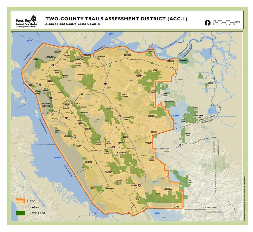
5 Two County Trails LLD
6
7 Two County Trails LLD Includes all of Alameda County and all of Contra Costa County, except Murray Township in eastern Alameda County and Liberty Union High School District in eastern Contra Costa County are exempt. The acquisitions and improvements to be maintained, improved, and serviced by the assessments include parklands, trails, and related parkland access improvements throughout the District. The District improvements are generally as follows: Current and to be developed, paved and unpaved trails located within the District s parklands, and regional trails as shown on the District s current Master Plan map Including vault toilets at various locations
8 Two County Regional Trails Alameda Creek Trail Briones to Las Trampas Regional Trail Briones to Mt. Diablo Regional Trail California Riding and Hiking Trail Contra Costa Canal Regional Trail Delta de Anza Regional Trail Iron Horse Regional Trail Lafayette-Moraga Regional Trail San Francisco Bay Trail Juan Bautista de Anza National Historic Trail Black Diamond to Mt. Diablo Skyline Trail Ohlone Wilderness Trail
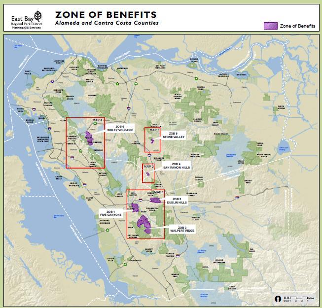
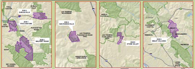
9 Zones of Benefit Zones of Benefit 1, 2, and 3 lie within the District and Alameda County: Five Canyons - backpack camp and toilet Dublin Hills Martin Canyon trail staging area Walpert Ridge trail, toilet, staging area improvements Zones of Benefit 4, 5, and 6 lie within the District and Contra Costa County: San Ramon Hills Calaveras Ridge trail rock Stone Valley trail, culvert, road grading, goat grazing Sibley Volcanic Regional Preserve trail maintenance, other improvements to dedicated parkland
10
11
12 LLD & ZOB Funding Two County LLD Zones of Benefit Annual Revenue $4,345,850 $202,860 Estimated Uses $4,970,613 $844,889 Estimated Ending Account Balance $1,820,544 $238,557 Budgeted FTEs 34 FTEs.55 FTEs
13 Two County Trails LLD and ZOB Actions requested today: Adopt Resolution of Intention Preliminary approval of draft Engineer s Report Set date of Public Hearing
14 History of East Contra Costa County Lighting & Landscaping District In the beginning EBRPD did not encompass all of the 2 counties In 1981, the District annexed East Contra Costa County to be part of EBRPD, without benefit of additional property tax. A Citizen s Task Force was convened to figure out how to fund the newly annexed area, which was rapidly changing from farmland and ranches to residential development. In 1991, the LLD was formed to fund maintenance and operations in the East Contra Costa County area. Assessment $19.70 per SFR parcel has not changed in 25 years!
15 East Contra Costa County LLD The District is defined by the boundaries of the Liberty Union High School District, in east Contra Costa County The acquisitions and improvements to be maintained, improved, and serviced by the assessments include parklands, trails, and related parkland access improvements throughout the District
16 East Contra Costa County Marsh Creek Trail Delta/De Anza Trail Big Break Trail ECCC Trails Service Yard Vasco Caves Regional Preserve Round Valley Regional Preserve Delta Access

17 East CC County LLD

18 What are boundaries for the East Contra Costa County LLD? The ECCC LLD is defined by the boundaries of the Liberty Union High School District, in east Contra Costa County
19 East Contra Costa County ECCC LLD Annual Revenue $761,587 Estimated Ending Account Balance $336,770 Budgeted FTEs 4.86 FTEs
20 East Contra Costa County LLD Actions requested today: Adopt Resolution of Intention Preliminary approval of draft Engineer s Report Set date of Public Hearing
21 Landscaping & Lighting Districts (LLDs) and Zones of Benefit (ZOB) Questions?

22 How does $19.70 per parcel add up? Fund 2017 revenue budget ECCC LLD $701,800
 Staff at Round Valley and operational costs: The level of operations, maintenance and")
23 What are ECCC LLD funds for? Staff at East County Trails and Parks: Delta de Anza Trail, Marsh Creek Trail, Big Break Trail, etc. Big Break Shoreline Bay Point Shoreline Antioch-Oakley Shoreline Nunn Property & Delta Access (land-banked) Staff at Round Valley and operational costs: The level of operations, maintenance and servicing include, but are not limited to: culvert service and repair, drinking fountains repair, entry structure repair, erosion control, fence repair, fire suppression, inlet, pipeline and outfall service and repair, litter control, mowing, painting, ranger patrol, repaving and crack repair, rest room maintenance, sign maintenance, stair tread repair, tree and shrubbery trimming and removal, weed abatement, landscaping, grading and soil preparation. The operations, maintenance and service include personnel, electrical energy, and utilities
24 How much do we spend to operate parks in East Contra Costa County? Location Operating Budget Round Valley $121,580 Vasco Caves $55,210 Vasco Hills $313,960 Antioch-Oakley Shoreline $176,730 Big Break Shoreline $357,700 Delta De Anza Trail $28,950 East Contra Costa Trails $546,460 Marsh Creek Trail $3,240 Big Break Visitors Center $618,520 TOTAL $2,222,350 ECCC Funding Sources Operating Budget General Fund $1,001,808 ECCC LLD $641,410 Other non-capital $579,132
CITY OF LAFAYETTE CALIFORNIA. Trails Implementation Plan
 CITY OF LAFAYETTE CALIFORNIA s Implementation Plan Version Date: November 27, 20063, 2013 PURPOSE The Lafayette s Implementation Plan is a companion document to the Lafayette s Master Plan. The Implementation
CITY OF LAFAYETTE CALIFORNIA. Trails Implementation Plan
 CITY OF LFYETTE CLIFORNI PURPOSE The Lafayette is a companion document to the Lafayette Trails Master Plan. The Implementation Plan is a working document intended to provide more current, and more fine-grained,
Wonderments Calendar
 Wonderments 2015 Calendar Ohlone Regional Wilderness. Photo: Jason Armstrong January 2015 High ridges and deep shady canyons await visitors at Ohlone Regional Wilderness in southern Alameda County. The
2013 Calendar. Follow a Trail
 2013 Calendar Follow a Trail Point Pinole Regional Shoreline. Photo: Marc Crumpler January 2013 January kicks off the 20th anniversary of the Park District s popular Trails Challenge self-guided hiking
City of Durango 5.8 FUNDING TRAILS DEVELOPMENT
 5.8 FUNDING TRAILS DEVELOPMENT The City has been successful in establishing dedicated local funding sources as well as applying for grants to develop the City s trail system, having received nearly $2.4
Martinez General Plan 2035 White Paper TRAILS
 Martinez General Plan 2035 White Paper TRAILS November 2016 The Issue The draft Martinez General Plan 2035 and Draft Program Environmental Impact Report were released for public review on September 15,
CITY OF AMERICAN CANYON COUNCIL AGENDA STAFF REPORT. Meeting Date: August 4, 2009 PUBLIC HEARING: 9 SUBJECT
 CITY OF AMERICAN CANYON COUNCIL AGENDA STAFF REPORT SUBJECT Meeting Date: August 4, 2009 PUBLIC HEARING: 9 Adopt a Resolution approving the annual Engineer s Report, confirming the assessment diagram and
PLANNING COMMISSION AGENDA REPORT May 10, Members of the Planning Commission. Joyce Parker-Bozylinski, Contract Planner
 PLANNING COMMISSION AGENDA REPORT May 10, 2007 TO: FROM: PROPOSAL: APPLICANT: RECOMMENDATION: Members of the Planning Commission Joyce Parker-Bozylinski, Contract Planner Approval of the Calabasas Trails
Fee:$O.OO P DAWSON CTY, MT Rec/Filed 1
 462708 Fee:$O.OO P DAWSON CTY, MT Rec/Filed 1 Shirley Kreiman, Clk & Rcdr By..; I ~::::!o:::!::::~~!..!:!~~~~ RETURN TO: FILED RESOLUTION 2017-33 RESOLUTION OF INTENTION TO CREATE RURAL SPECIAL IMPROVEMENT
Non-motorized Trail Plan & Proposal. August 8, 2014
 Town of Star Valley Ranch, Wyoming and the Star Valley Ranch Association in partnership with the USDA Forest Service, Bridger-Teton National Forest, Greys River Ranger District Non-motorized Trail Plan
Ohlone Portola Heritage Trail. San Mateo County Park and Recreation Commission August 3, 2017
 Ohlone Portola Heritage Trail San Mateo County Park and Recreation Commission August 3, 2017 Background 2014 Paul Reimer, a retired engineer and former POST Board member, documented the coastal trail
Tri-Valley Residential Real Estate Market Update
 Tri-Valley Residential Real Estate Market Update Real Estate Market Drivers Unemployment US vs CA Jan. 2018: US 4.1% & Dec. 2017: CA 4.3% 14% CA US 12% 10% 8% 6% 4% 2% 0% SERIES: Unemployment Source: California
COASTAL CONSERVANCY. Staff Recommendation December 2, 2004 COYOTE HELLYER COUNTY PARK BAY AREA RIDGE TRAIL
 COASTAL CONSERVANCY Staff Recommendation December 2, 2004 COYOTE HELLYER COUNTY PARK BAY AREA RIDGE TRAIL File No. 04-057 Project Manager: Amy Hutzel RECOMMENDED ACTION: Authorization to disburse up to
Stephen Rusher
 39 3 0 13-0393 10/14 CONTACT T AGENTS: Stephen Rusher 925.974.0115. srusher@newmarkccarey.com r@ne care rey. co m CA RE License e# #01439740 40 Lone Tree Plaza is is a a ±477,000 ±477,000 square square
Community Development
 Community Development City & Borough of Juneau Community Development 155 S. Seward Street Juneau, AK 99801 (907) 586 0715 Phone (907) 586 4529 Fax DATE: February 11, 2016 TO: FROM: Planning Commission
Sibley LUPA. Board Executive Committee Meeting December 7, 2017
 Sibley LUPA Board Executive Committee Meeting December 7, 2017 Project Location & Project Area 1,318-acre Robert Sibley Volcanic Regional Preserve Project Area Purpose Project Purpose & Goals Append the
Business Item No XXX. Proposed Action That the Metropolitan Council approve the Coon Creek Regional Trail Master Plan.
 Business Item No. 2015-XXX Metropolitan Parks and Open Space Commission Meeting date: July 7, 2015 For the Community Development Committee meeting of July 20, 2015 For the Metropolitan Council meeting
Twin Rivers Annual Report 2017
 Twin Rivers Annual Report 2017 Summary of our volunteer efforts for 2017 Volunteer Hours 2249 hours Trail Miles Cleared 37 miles Vehicle Miles Driven 10198 miles Equipment Hours 79 hours Stock Days 193
ORDINANCE NO. 510 THEREFORE, BE IT ORDAINED BY THE GOVERNING BODY OF THE CITY OF BEL AIRE, KANSAS:
 (Published in The Ark Valley News on July, 2012.) ORDINANCE NO. 510 S-I-1 GILMORE & BELL, P.C. 07/11/2012 AN ORDINANCE CREATING A COMMUNITY IMPROVEMENT DISTRICT IN THE CITY OF BEL AIRE, KANSAS; AUTHORIZING
Department of Regional Parks
 Department of Regional Parks 5/16/2016 Director Jeffrey R. Leatherman Overview of Regional Park Facilities May 2016 Sacramento County Regional Parks 2 Facilities with Community Partnerships/ Concessions
Natural Environment and Public Spaces
 CHAPTER 3 Natural Environment and Public Spaces acres for each 1,000 residents. The park standard in the subdivision ordinance established by the 1989 General Plan is 5 acres of parkland for every 1,000
Logo Department Name Agency Organization Organization Address Information 5700 North Sabino Canyon Road
 Logo Department Name Agency Organization Organization Address Information United States Forest Coronado National Forest 5700 North Sabino Canyon Road Department of Service Santa Catalina Ranger District
Finding aid of the Central Files
 http://oac.cdlib.org/findaid/ark:/13030/c8g165z3 No online items Finding aid of the Central Files Sonia Collazo Sequoia & Kings Canyon National Parks 47050 Generals Highway Three Rivers, CA 93271-9700
Update on the I-680 Transit Corridor Improvement Project HOV on/off Ramps Environmental Impact Report Community Engagement Plan
 Update on the I-680 Transit Corridor Improvement Project HOV on/off Ramps Environmental Impact Report Community Engagement Plan Presentation Overview Introductions Susan Miller, Director of Projects, Contra
CITY OF PEMBROKE 2004 BUDGET. July 6, 2004
 2004 BUDGET July 6, 2004 2004 TAX RATES Municipal Education Total Residential 0.01434078 0.00296000 0.01730078 Multi-residential 0.02674555 0.00296000 0.02970555 Commercial 0.02940061 0.02268611 0.05208672
Miller/ Knox Regional Shoreline
 East Bay Regional Park District Board Meeting March 19 th, 2019 Miller/ Knox Regional Shoreline Land Use Plan Amendment Miller/Knox Regional Shoreline 1960 s EBRPD Expands to Contra Costa County Only 64
2015 Bond Proposal Model Airplane Parks (PR96) Alternative Model Airplane Park Location
 Alternative Model Airplane Park Location") Our club, Green Valley R/C Flyers, is presenting this proposal for consideration as an alternative location for a Model Airplane Park to be included in PR96 for the 2015 Bond Election. We are recommending
Our club, Green Valley R/C Flyers, is presenting this proposal for consideration as an alternative location for a Model Airplane Park to be included in PR96 for the 2015 Bond Election. We are recommending
115 CENTER AVE, PACHECO, CA
 EXECUTIVE SUMMARY FEDEX EXPRESS CORPORATION 11 CENTER AVE, PACHECO, CA DOUGLAS LONGYEAR, SIOR +1 1 677 08 doug.longyear@cushwake.com CA Lic #00829911 BROOKS PEDDER, SIOR +1 92 627 2 brooks.pedder@cushwake.com
SONOMA LOCAL AGENCY FORMATION COMMISSION 111 SANTA ROSA AVENUE, SUITE 240, SANTA ROSA, CA (707)
") SONOMA LOCAL AGENCY FORMATION COMMISSION 111 SANTA ROSA AVENUE, SUITE 240, SANTA ROSA, CA 95404 (707) 565-2577 www.sonomalafco.org Item 4.2 Staff Report Meeting Date: February 6, 2019 Agenda No. Item 4.2
SONOMA LOCAL AGENCY FORMATION COMMISSION 111 SANTA ROSA AVENUE, SUITE 240, SANTA ROSA, CA 95404 (707) 565-2577 www.sonomalafco.org Item 4.2 Staff Report Meeting Date: February 6, 2019 Agenda No. Item 4.2
HEADQUARTERS WEST LTD. CATTLE RANCHES HORSE PROPERTIES RURAL REAL ESTATE
 Aravaipa Creek Flowing Through the Property Offered for sale exclusively by: Sandy Ruppel Headquarters West, Ltd. PO BOX 542 Sonoita, AZ 85637 Phone (520) 444-1745 sandy@headquarterswest.com www.headquarterswest.com
JOHN CHIANG California State Controller
 JOHN CHIANG California State Controller Division of Accounting and Reporting January 25, 2013 COUNTY AUDITORS RESPONSIBLE FOR STATE TRANSIT ASSISTANCE FUNDS TRANSPORTATION PLANNING AGENCIES COUNTY TRANSPORTATION
Committee Report. Community Development Committee For the Metropolitan Council meeting of August 12, Business Item No.
 Committee Report Business Item No. 2015-168 Community Development Committee For the Metropolitan Council meeting of August 12, 2015 Subject: Coon Creek Regional Trail Master Plan, Anoka County Proposed
Wool Ranch 20 Acres 20 +/- acres Sunol, CA Alameda County
 Wool Ranch 20 Acres 20 +/- acres Sunol, CA Alameda County 707 Merchant Street Suite 100 Vacaville, CA 95688 707-455-4444 Office 707-455-0455 Fax californiaoutdoorproperties.com CalBRE# 01838294 Introduction
2055 CESSNA DRIVE. Vacaville Business Park Vacaville, CA. ±9,149 Square Feet For Lease Warehouse Building
 20 CESSNA DRIVE Vacaville Business Park Vacaville, CA ±9,19 Square Feet For Lease Warehouse Building 20 CESSNA DRIVE VACAVILLE BUSINESS PARK SNA CES LEASED VE DRI BUILDING A 201 CESSNA DRIVE ±10 BUILDING
CITY OF PALMDALE. REPORT to the Mayor and Members of the City Council from the City Manager
 CITY OF PALMDALE REPORT to the Mayor and Members of the City Council from the City Manager DATE: February 4, 2015 SUBJECT: Zone Verification 14-017; 155 acres Located on the North Side of Avenue P at 30th
US Forest Service Bears Ears Trail - NFST 1144 California Park to Hole in Wall Creek. Good (1) 2 3
 2 3") Trail Maintenance Endowment Fund Trail Criteria Form The Trail Maintenance Endowment Fund (TMEF) grant criteria form is used in determining the use of funds available on an annual basis. Decisions on how
Trail Maintenance Endowment Fund Trail Criteria Form The Trail Maintenance Endowment Fund (TMEF) grant criteria form is used in determining the use of funds available on an annual basis. Decisions on how
2014 CALENDAR Our Heritage: Celebrating 80 Years of Regional Parks
 2014 CALENDAR Our Heritage: Celebrating 80 Years of Regional Parks CELEBRATING 80 YEARS Martin Luther King Jr. Regional Shoreline Photo: SLPDC #468 Photo: Claire Ames Then: The area including what is now
Bear Creek Habitat Improvement Project
 06/10/10 Bear Creek Habitat Improvement Project El Paso County, Colorado Pike National Forest and Colorado Springs Utilities Owned Land Report prepared by: Eric Billmeyer Executive Director Rocky Mountain
REPORT to the Mayor and Members of the City Council from the City Manager
 CITY OF PALMDALE REPORT to the Mayor and Members of the City Council from the City Manager DATE: September 3, 2014 SUBJECT: ISSUING DEPARTMENT: Memorandum of Understanding Between the City of Palmdale
HIGHWAY 17 WILDLIFE and REGIONAL TRAIL CROSSINGS
 HIGHWAY 17 WILDLIFE and REGIONAL TRAIL CROSSINGS Agenda and Meeting Format 7:00-7:15 Welcome 7:15-8:00 Presentation 8:00-8:30 Open House 8:30 Recap 9:00 Conclusion 2 Meeting Goals: Introduce the project
6/28/11 TELEPHONE (n=400, RDD) AND ON-LINE (n=6,294) SURVEY RESULTS
 AND ON-LINE (n=6,294) SURVEY RESULTS") 6/28/11 TELEPHONE (n=0, RDD) AND ON-LINE (n=6,294) SURVEY RESULTS Update Surveys An Institute for Consensus Building www.sri-consulting.org MASTER PLAN UPDATE 6/28/11 Quantifying the responses from the
6/28/11 TELEPHONE (n=0, RDD) AND ON-LINE (n=6,294) SURVEY RESULTS Update Surveys An Institute for Consensus Building www.sri-consulting.org MASTER PLAN UPDATE 6/28/11 Quantifying the responses from the
Allocation of the Education Revenue Augmentation Fund for Community College Districts
 STATE OF CALIFORNIA BRICE HARRIS, CHANCELLOR CALIFORNIA COMMUNITY COLLEGES SYSTEM OFFICE 1102 Q STREET SACRAMENTO, CA 95811-6549 (916) 445-8752 HTTP://WWW.CCCCO.EDU June 4, 2013 To: From: Subject: Auditors
Cascade River State Park Management Plan Amendment
 This document is made available electronically by the Minnesota Legislative Reference Library as part of an ongoing digital archiving project. http://www.leg.state.mn.us/lrl/lrl.asp Cascade River State
Williamson Rock/Pacific Crest National Scenic Trail (PCT) Project EIS. Notice of intent to prepare an Environmental Impact Statement.
 Project EIS. Notice of intent to prepare an Environmental Impact Statement.") [3411-15-P] DEPARTMENT OF AGRICULTURE Forest Service Angeles National Forest; Los Angeles County, CA Williamson Rock/Pacific Crest National Scenic Trail (PCT) Project EIS AGENCY: ACTION: Forest Service,
[3411-15-P] DEPARTMENT OF AGRICULTURE Forest Service Angeles National Forest; Los Angeles County, CA Williamson Rock/Pacific Crest National Scenic Trail (PCT) Project EIS AGENCY: ACTION: Forest Service,
BLACK POINT COMMUNITY PLAN UPDATE ADVISORY COMMITTEE
 BLACK POINT COMMUNITY PLAN UPDATE ADVISORY COMMITTEE Thursday, March 20, 2014 6:00 8:00 PM Novato Atherton Fire Department Training Room 450 Atherton Avenue Novato, CA 94945 AGENDA 1. Review and accept
Estimated Allocation of the Education Revenue Augmentation Fund for Community College Districts
 STATE OF CALIFORNIA BRICE HARRIS, CHANCELLOR CALIFORNIA COMMUNITY COLLEGES SYSTEM OFFICE 1102 Q STREET SACRAMENTO, CA 95811-6549 (916) 445-8752 HTTP://WWW.CCCCO.EDU June 10, 2015 To: From: Subject: Auditors
Estimated Allocation of the Education Revenue Augmentation Fund for Community College Districts
 STATE OF CALIFORNIA BRICE HARRIS, CHANCELLOR CALIFORNIA COMMUNITY COLLEGES SYSTEM OFFICE 1102 Q STREET SACRAMENTO, CA 95811-6549 (916) 445-8752 HTTP://WWW.CCCCO.EDU June 16, 2014 To: From: Subject: Auditors
City Council Report 915 I Street, 1 st Floor Sacramento, CA
 City Council Report 915 I Street, 1 st Floor Sacramento, CA 95814 www.cityofsacramento.org File ID: 2017-01418 December 12, 2017 Consent Item 10 Title: Designating the Miller Regional Park Parking Lots
COASTAL CONSERVANCY. Staff Recommendation June 5, 2008 GUALALA BLUFF TRAIL OPERATIONS AND MAINTENANCE
 COASTAL CONSERVANCY Staff Recommendation June 5, 2008 GUALALA BLUFF TRAIL OPERATIONS AND MAINTENANCE File No. 08-047-01 Project Manager: Deborah Hirst RECOMMENDED ACTION: Consideration and possible Conservancy
Estimated Allocations of the Education Revenue Augmentation Fund for Community College Districts
 STATE OF CALIFORNIA BRICE W. HARRIS, CHANCELLOR CALIFORNIA COMMUNITY COLLEGES CHANCELLOR S OFFICE 1102 Q STREET, STE. 4554 SACRAMENTO, CA 95811-6549 (916) 445-8752 http://www.cccco.edu MEMORANDUM Date:
MINUTES FILED WITH TOWN CLERK
 Page 1 of 7 Town of Farmington Parks Master Plan Advisory Committee FILED WITH TOWN CLERK January 28, 2015 TOWN OF FARMINGTON PARKS MASTER PLAN ADVISORY COMMITTEE MINUTES OF THE MEETING OF JANUARY 28,
Region MHz channel selection and usage documentation. Version 6
 Region 6 700 MHz channel selection and usage documentation Version 6 Applicant information The Golden Gate Bridge, Highway and Transportation District is a Special District formed by the California Legislature
CHAPTER 6 NOISE EXPOSURE
 CHAPTER 6 NOISE EXPOSURE FAA requires that the NEM submitted for review represent the aircraft noise exposure for the year of submittal (in this case 2008) and for a future year (2013 for OSUA). However,
BACK COUNTRY UNIT PREFERRED ALTERNATIVE
 BACK COUNTRY UNIT PREFERRED ALTERNATIVE San Francisco (118 mi) Carmel-By-The-Sea Carmel River Carmel Valley Road State Beach Private Property Point Lobos State Reserve Point Lobos Ranch RUSTIC CAMPING
Honorable Mayor and Members of the City Council. Submitted by: Scott Ferris, Acting Director, Parks Recreation & Waterfront
 Office of the City Manager PUBLIC HEARING May 21, 2013 To: From: Honorable Mayor and Members of the City Council Christine Daniel, City Manager Submitted by: Scott Ferris, Acting Director, Parks Recreation
Ardith Reservoir and Donald Pumping Plant. Figures 3.3-ARRES-1 to 3.3-ARRES-7
 Ardith Reservoir and Donald Pumping Plant Figures 3.3-ARRES-1 to 3.3-ARRES-7 feet Ivy Drive Moraga Way Leslee Lane Proposed Donald Pumping Plant A10 A12 A11 Proposed Ardith Reservoir Existing A2 Donald
Welcome to the future of Terwillegar Park a Unique Natural Park
 Welcome to the future of Terwillegar Park a Unique Natural Park 1 Introduction The Terwillegar Park Concept Plan study will develop an overall concept plan, management objectives and development guidelines
WASHTENAW COUNTY PARKS AND RECREATION COMMISSION
 WASHTENAW COUNTY PARKS AND RECREATION COMMISSION - BUDGET PROPOSED FISCAL YEARS JANUARY 1, DECEMBER 31, And PROJECTED FISCAL YEARS JANUARY 1, DECEMBER 31, Robert L. Tetens, Director TABLE OF CONTENTS Millage
FINAL TESTIMONY 1 COMMITTEE ON RESOURCES UNITED STATES HOUSE OF REPRESENTATIVES. July 13, 2005 CONCERNING. Motorized Recreational Use of Federal Lands
 FINAL TESTIMONY 1 STATEMENT OF DALE BOSWORTH CHIEF Of the FOREST SERVICE UNITED STATES DEPARTMENT OF AGRICULTURE Before the SUBCOMMITTEE ON FORESTS AND FOREST HEALTH And the SUBCOMMITTEE ON NATIONAL PARKS,
2 Trails sc Challenge is sapoga program of East Bay Regional ego Park District in pat partnership es pwt with... Photo: Mona Koh
 Trails Challenge is a free program made possible through a partnership between the East Bay Regional Park District, the Regional Parks Foundation, and Kaiser Permanente 2 Trails sc Challenge is sapoga
2. RESOLUTION TO CLOSE MEETING
 THE CORPORATION OF THE CITY OF VERNON A G E N D A To deliver effective and efficient local government services that benefit our citizens, our businesses, our environment and our future REGULAR OPEN MEETING
Business Item No xx
 Business Item No. 2015-xx Metropolitan Parks and Open Space Commission Meeting date: April 7, 2015 For the Community Development Committee meeting of April 21, 2015 For the Metropolitan Council meeting
Environment and Natural Resources Trust Fund (ENRTF) M.L ENRTF Work Plan (Main Document)
 M.L ENRTF Work Plan (Main Document)") Environment and Natural Resources Trust Fund (ENRTF) M.L. 2018 ENRTF Work Plan (Main Document) Today s Date: December 8, 2017 Date of Next Status Update Report: January 31, 2019 Date of Work Plan Approval:
Environment and Natural Resources Trust Fund (ENRTF) M.L. 2018 ENRTF Work Plan (Main Document) Today s Date: December 8, 2017 Date of Next Status Update Report: January 31, 2019 Date of Work Plan Approval:
WELCOME TO YOUR REGIONAL AIRPORT AUTHORITY MEETING OF THE CITY OF MERCED AGENDA
 WELCOME TO YOUR REGIONAL AIRPORT AUTHORITY MEETING OF THE CITY OF MERCED AUTHORITY MEMBERS Larry Morelock-Chair, Alvin Osborn-Vice-Chair, John Sundgren, Rodrigo Flores, Ryan Smith, and Michael Bodine.
RECREATION ACCESS AND COMMUNITY ENRICHMENT PLAN
 Template for facilitating Siskiyou County, the City of Yreka and the State of Jefferson in a RECREATION ACCESS AND COMMUNITY ENRICHMENT PLAN Access to the Mountains CREATING ACCESS TO PUBLIC AND PRIVATE
salisbury canyon - Ranch new cuyama, California
 Operations/ Recreation 100 Road New Cuyama, California Due to its rustic ambience, privacy, and pristine condition, Ranch (considered by many to be nicest ranch in Cuyama Valley) is a working cattle ranch.
Q2 MARKET REPORT SAN FRANCISCO EAST BAY PENINSULA SOUTH BAY
 Q2 MARKET REPORT SAN FRANCISCO EAST BAY PENINSULA SOUTH BAY IT S MORE THAN A HOME, IT S YOUR LIFE. BERNAL HEIGHTS 1:03 PM SAN FRANCISCO SAN FRANCISCO SALES WERE UP BY 7.4% FOR AND BY 2.7% FOR. MEDIAN SALES
2321 Filbert Street OAKLAND. O f f e r i n g M e m o r a n d u m. EXCLUSIVE AGENT TOM SOUTHERN CA RE License #
 2321 Filbert Street OAKLAND O f f e r i n g M e m o r a n d u m EXCLUSIVE AGENT TOM SOUTHERN 510.923.9158 tsouthern@ngkf.com CA RE License #01808807 EXECUTIVE SUMMARY Newmark Knight Frank is pleased to
TRUCKEE TAHOE AIRPORT DISTRICT BOARD OF DIRECTOR STAFF REPORT
 AGENDA ITEM: 11 TRUCKEE TAHOE AIRPORT DISTRICT BOARD OF DIRECTOR STAFF REPORT AGENDA TITLE: MEETING DATE: January 24, 2018 PREPARED BY: NTPUD Agency Partnership Opportunity, Multi-Use Trailhead Access
Section II. Planning & Public Process Planning for the Baker/Carver Regional Trail began in 2010 as a City of Minnetrista initiative.
 Section II Planning & Public Process Planning for the began in 2010 as a City of initiative. city staff began discussions with the Park District on the possibility of a north/south regional trail connection
County of Sonoma Agenda Item Summary Report
 Revision No. 20170501-1 of Sonoma Agenda Item Summary Report Agenda Item Number: 37 (This Section for use by Clerk of the Board Only.) Clerk of the Board 575 Administration Drive Santa Rosa, CA 95403 To:
PALO CORONA REGIONAL PARK MPRPD BOARD MEETING AUGUST 8, 2018
 PALO CORONA REGIONAL PARK MPRPD BOARD MEETING AUGUST 8, 2018 ACKNOWLEDGEMENTS AGENCIES AND ORGANIZATIONS The Trust for Public Land Big Sur Land Trust Santa Lucia Conservancy California State Parks Point
Kelly Motorized Trails Project Proposed Action
 Kelly Motorized Trails Project Proposed Action November 28, 2011 The Flagstaff Ranger District of the Coconino National Forest is seeking public input on the proposed Kelly Motorized Trails Project (formerly
APPENDIX A DATA COLLECTION BIBLIOGRAPHY SANTA CLARA COUNTY I-680 CORRIDOR STUDY
 APPENDIX A DATA COLLECTION BIBLIOGRAPHY APPENDIX A DATA COLLECTION BIBLIOGRAPHY This section of the I-680 Corridor Study presents a summary (or bibliography) of the data that was collected and reviewed
PUBLIC INFORMATION SESSION #2
 Highway 16, Highway 779 to Kapasiwin Road, Planning Study PUBLIC INFORMATION SESSION #2 Wednesday June 20, 2012 4 to 8 pm HIGHWAY 16 Highway 779 to Kapasiwin Road Functional Planning Study Blueberry Community
$10,900,000 or Potential J.V., Seller Financing, Take Downs, etc. Available
 $10,900,000 or Potential J.V., Seller Financing, Take Downs, etc. Available 451.50 gross acres Lots from 1.7-93.50 acres Ocean views Shown by Appointment ONLY subject property Escondido Escondido Lee &
I. Call to Order. A. Invocation. B. Pledge of Allegiance. Employee Awards. Public Information Update. 1. PIO Update- Page: 6
 Agenda Okaloosa County Board of Commissioners Tuesday, April 16, 2019 8:30 AM Okaloosa County Administration Building In accordance with Section 286.011, Florida Statutes, this meeting was publicly noticed
Hoover Wilderness Region Trail Map: Twin Lakes, Lundy Lake, Bridgeport, Green Creek, Virginia Lakes, Buckeye Creek, Leavitt Meadows, Matterhorn Peak,
 Hoover Wilderness Region Trail Map: Twin Lakes, Lundy Lake, Bridgeport, Green Creek, Virginia Lakes, Buckeye Creek, Leavitt Meadows, Matterhorn Peak, (Tom Harrison Maps) By Tom Harrison If searched for
e-news TRACK REGENERATION WORK AT DINGO DELL, WEST OF SYDNEY.
 e-news TRACK REGENERATION WORK AT DINGO DELL, WEST OF SYDNEY. By the project coordinator, Matt Barnes, Public Relations Officer for the Land Rover Owners Club of Australia (Sydney Branch) Inc One of the
MASTER PLAN EXECUTIVE SUMMARY
 Biscuit Run State Park Scottsville Road (State Route 20) Charlottesville, VA 22902 Biscuit Run State Park MASTER PLAN EXECUTIVE SUMMARY Department of Conservation and Recreation Division of Planning and
Lake Wissota Access Locations within the LaFayette Township. By Chad Martin
 Lake Wissota Access Locations within the LaFayette Township By Chad Martin Anson/ Wissota Access Point # 1 Road: 195 th St. Associated Fire Numbers: 13294 Defining Characteristics: Forested from road
Appendix 15B Delta Recreation Recreation Setting and California State Park Recommendations by County
 Appendix B Recreation Setting and California State Park Recommendations by County 0 The Delta occupies an area of more than,00 square miles at the confluence of the Sacramento and San Joaquin Rivers. It
RIO VISTA MUNICIPAL AIRPORT
 DRAINAGE TECHNICAL MEMORANDUM RIO VISTA MUNICIPAL AIRPORT RIO VISTA, CALIFORNIA Prepared for: City of Rio Vista 1 Main Street Rio Vista, CA 94571 (707) 374-5337 Prepared by: August 2012 Copyright 2012
S Central Coast Heritage Protection Act APRIL 21, 2016
 STATEMENT OF GLENN CASAMASSA ASSOCIATE DEPUTY CHIEF, NATIONAL FOREST SYSTEM U.S. FOREST SERVICE U.S. DEPARTMENT OF AGRICULTURE BEFORE THE UNITED STATES SENATE COMMITTEE ON ENERGY AND NATURAL RESOURCES
Mayor Mayor Redcay reported that he spent the week at the Denver Fair and also participated in the Annual Celebrity Wing Eating Contest.
 October 8, 2018 The October 8 th meeting of Denver Borough Council was called to order at 7:00 p.m. with the following Councilmembers present: Stewart, Flory, South, Rogers, Daub, and Mayor Redcay. The
NAVAJO COMMUNITY PLAN
 NAVAJO COMMUNITY PLAN Prepared by the NAVAJO COMMUNITY PLANNERS and THE CITY OF SAN DIEGO City of San Diego Planning Department 202 C Street, MS 4A San Diego, CA 92101 Printed on recycled paper. This information,
CITY OF LOS ANGELES INTER-DEPARTMENTAL MEMORANDUM
 CITY OF LOS ANGELES INTER-DEPARTMENTAL MEMORANDUM DATE: September 12, 2016 TO: FROM: The Honorable City Council c/o City Clerk, Room 395, City Hall Attention: Honorable Mike Bonin, Chair, Transportation
COASTAL CONSERVANCY. Staff Recommendation November 6, 2008 SAN FRANCISCO BAY TRAIL: CANAL BOULEVARD CONSTRUCTION
 COASTAL CONSERVANCY Staff Recommendation November 6, 2008 SAN FRANCISCO BAY TRAIL: CANAL BOULEVARD CONSTRUCTION File No. 07-037-02 Project Manager: Michelle Jesperson RECOMMENDED ACTION: Authorization
BROCHURE Pilot Hill Ranch 304 Acres +/- Pilot Hill, CA. Presented by Jim Copeland
 BROCHURE Pilot Hill Ranch 304 Acres +/- Pilot Hill, CA Presented by Jim Copeland 1 The Property This gently rolling 304 acres of ranchland is located in Pilot Hill, midway between the historic California
CHAPTER 1 INTRODUCTION MORENO VALLEY GENERAL PLAN 1. INTRODUCTION. 1.1 What is a General Plan?
 1. INTRODUCTION 1.1 What is a General Plan? A General Plan is a comprehensive long-term strategy for the physical development of a city. It determines how land may be used and the infrastructure and public
Information: Take a tour of station, have the boys practice a skit to make a video. The station will give you a copy to reproduce for the boys.
 1. Briones Camp Out Activity: Camp out inside group round house with fire pit inside, or tent camp out-side Age group: All Time of year: Spring, Fall, Summer. RSVP: East Bay Regional Parks (888-327-2757),
The road project is proposed to begin late-2016 and continue over a period of several years. Based on current Florida State Statutes, and the
 The road project is proposed to begin late-2016 and continue over a period of several years. Based on current Florida State Statutes, and the direction of the CPA audit performed in 2014, we must adopt
Three Canyons Ranch Master Homeowners' Association Board Meeting Minutes July 19, 2014 (approved at 8 Oct 2014 board meeting)
") Three Canyons Ranch Master Homeowners' Association Board Meeting Minutes July 19, 2014 (approved at 8 Oct 2014 board meeting) 1. Meeting called to order at 10:19am Board Members present: Eileen McMannon
Three Canyons Ranch Master Homeowners' Association Board Meeting Minutes July 19, 2014 (approved at 8 Oct 2014 board meeting) 1. Meeting called to order at 10:19am Board Members present: Eileen McMannon
::f BOA OF AIRPORT COMMISSIONERS REPORT TO THE. -A. A_ A.4k fig
 3/3/208 2/26/208 Approval NY a NY Y RW JH BOA /...-_ 0...0 00:4.4 Los Angeles World Airports REPORT TO THE OF AIRPORT COMMISSIONERS -A. A_ A.4k._ra. At, Approved y: Dave Jones - Air.n:TPro:-.,. oncession
Santa Cruz North Interior
 Santa Cruz North Interior The Santa Cruz North Interior planning area includes the area commonly referred to as the San Lorenzo Valley. The greatest amount of development occurs in the communities of Boulder
CLIMBING & CAMPING. Las Vegas District NATIONAL CONSERVATION AREA UNIVERSITY OF MINNESOTA LIBRARY. GQVERNMFMT Pi^l'.CiTIOKS
 Generated on 2015-08-13 23:03 GMT / http://hdl.handle.net/2027/umn.31951d00749307j Public Domain, Google-digitized / http://www.hathitrust.org/access_use#pd-google S3, a- RED ROCK CANYON a z NATIONAL CONSERVATION
BROCHURE Pilot Hill Meadows Acres Pilot Hill, California. Presented by Jim Copeland
 BROCHURE Pilot Hill Meadows 58.09 Acres Pilot Hill, California Presented by Jim Copeland 1 The Property This 58 acres is a portion of the 304 acre Pilot Hill Ranch in Pilot Hill and is a separate legal
OWNER/USER OPPORTUNITY FOR SALE 1611 NORTH MAIN STREET WALNUT CREEK, CA
 DOWNTOWN WALNUT CREEK OWNER/USER OPPORTUNITY FOR SALE 1611 NORTH MAIN STREET WALNUT CREEK, CA PLEASE DO NOT DISTURB TENANT PROPERTY DETAILS 1611 North Main Street, Walnut Creek, CA Building Area: ±5,129
Media Release For Immediate Release Tuesday, April 17, 2018
 Media Release For Immediate Release Tuesday, April 17, 2018 2018 Budget focuses on enhancements to roads and infrastructure Investing in roads and infrastructure is a priority for the County s 2018 budget.
Northeast Quadrant Distinctive Features
 NORTHEAST QUADRANT Northeast Quadrant Distinctive Features LAND USE The Northeast Quadrant includes all the area within the planning area that is east of Interstate 5 and to the north of State Route 44.