BOARD OF COUNTY COMMISSIONERS SARPY COUNTY, NEBRASKA
|
|
|
- Magdalene Barrett
- 5 years ago
- Views:
Transcription
1 ! BOARD OF COUNTY COMMISSIONERS SARPY COUNTY, NEBRASKA RESOLUTION AUTHORIZING THE BOARD TO RATIFY REVISIONS TO THE APPLICATION AND ATTACHMENTS RELATING TO THE RECREATIONAL TRAILS PROGRAM GRANT (RTP) WHEREAS, pursuant to Neb. Rev. Stat (6) (Reissue 2007), the County has the power to do all acts in relation to the concerns of the County necessary to the exercise of its corporate powers; and, WHEREAS, pursuant to Neb. Rev. Stat (Reissue 2007), the powers ofthe County as a body are exercised by the County Board; and, WHEREAS, a Recreational Trails Program Grant was available to Sarpy County through the Nebraska Game and Parks Commission; and, WHEREAS, the Recreational Trails Program Grant is for the development and extension of recreational biking and walking trails; and, WHEREAS, the grant was approved for submission by the County Board on September 27, 2011; and, WHEREAS, the Nebraska Game and Parks Commission requested revisions and clarifications relating to concrete depth and Right-of-Way on October 13, 2011 due no later than October 20, 2011; and, WHEREAS, the revisions were completed and submitted to the Nebraska Game and Parks Commission on October 20, 2011; and, WHEREAS, Sarpy County is committed to and supports the Recreational Trails Grant for the development and extension of the Marv Holubar Trail; and, NOW, THEREFORE, BE IT RESOLVED, By the Sarpy County Board of Commissioners that the revisions to the Recreational Trails Program Grant application and attachments are hereby approved. The above Resolution was approved by a vote ofthe Sa() Coun~ard of Commissioners at a public meeting duly held in accordance with applicable law on the :J5t" day of cfc, Sarpy County Board Chairman
2 Sarpy County Revised Application NEBRASKA GAME AND PARKS COMMISSION RECREATIONAL TRAILS PROGRAM GRANT APPLICATION FORM (Revised June 2 0 I 0) Applicant: Sarpy County I Project Contact: I Dennis Wilson Address: 1210 Golden Gate Drive, I Zip Code: Papillion, NE I dwilson@sarpy.com I Congressional 12 I Cell: Address: District: Business I Federal ID No: Telephone: Project Title: Development and extension of the Marv Holubar Trail Project Description: Sarpy County will develop and extend the current Marv Holubar Trail. The trail will be in two segments; extending 3000 feet south and east to Quail Creek and Lakewood Villages and 800 feet north past the Bellevue Soccer Complex to the rocked Papio Creek Trail. The trail will be paved 10 feet wide with 5 inches of depth. Legal Description: North Segment; Lying within the 42" 0 Street ROW, north of Twin Creek Drive to a point approximately 800 feet to the northwest on the easterly side of the road. South Segment; Beginning at Outlot A, Twin Creek Plaza Replat VI, heading south approximately 200 feet to the south property line, continuing south within the Hwy 370 ROW for a distance of300 feet, thence southerly along Outlot 1, 3 70 Pointe for a distance of approximately 1000 feet to the Maass Road ROW, thence northwesterly along the southern ROW of Maass Road approximately 1500 feet to the end point. Project Cost Data: See Cost Estimate for additional information 1. Development: I $175, Acquisitions: I $o I 3. Engineering I $3o,ooo 4. Total Cost: $205,800 I 5. Federal RTP Share (Maximum: 80% of the Total Project Cost): I $164,6oo I 6. Percent of 180% I Percent ofmatch: 120% Request: Local20% Matching Share: (Entire amount must be available at application time-5% in cash) 7. Cash: $41,200 Source: Sarpy County Public Works Budget/City of Bellevue Budget 8. Taxes: $ Source: 9. Donations: $ Source: 10. Other: $ Source: 11. Other: $ Source: 12. Total: $41,200 I

3 RECREATIONAL TRAILS PROGRAM GRANT ATTACHMENT Please complete and return with Grant Application 1. Name of Project: I Development and extension of the Marv Holubar Trail 2. Name of Sponsor: I Sarpy County 3. Kind of recipient- from Section 1302 (e) (3): [please check type of political subdivision on the appropriate linel D Municipal D Public Power District ~ County D School District/ College D Natural Resources District D Federal Agency D State D Other (Please list) I D Recognized Indian Tribe 4. Project Location: Municipality [Closest City, Town or I City of Bellevue, Nebraska Village] County: I Sarpy County Congressional District [# and Representative] 2, Rep. Lee Terry NE Legislative District [# and Representative] 3, Sen. Scott Price 5. Classification of Land [please check appropriate classification] Public: I D I Private: private: 1 1 Combination public and ~ Fee Simple Title: D I Easement: ~ I Lease:D 6. Permissible Use category(s)- Section 1302 (e)(l) Please indicate which categories the project belongs to D Maintenance and restoration of existing trails D Development and rehabilitation of trailside and trailhead facilities and trail linkages D Purchase and lease oftrail construction and maintenance equipment IX1 Construction of new trails (with restriction for new trails on Federal lands) D Acquisition of easements or property for trails D Assessment of trail conditions for accessibility and maintenance 7. Assured Access Funding category: from section 1302(e)(4)and(5)[please check one] Motorized I D I Non-Motorized I ~ I Diversified trail use I D I Trail uses permitted (list major uses of trail, i.e. pedestrians, equestrians, bicyclists, atv) Pedestrians, bicyclists 8. Estimated date of completion: I September 2013 I

4 Recreational Trails Program Grant Narrative Development and Extension of the Marv Holubar Trail Sarpy County, Nebraska and the City of Bellevue, Nebraska Revised Narrative 1. Narrative a. Purpose - The purpose of this grant request is the development and extension of the Marv Holubar Trail in Sarpy County and Bellevue, Nebraska. Developing and extending the Marv Holubar trail will help the community by boosting tourism, attracting investment, and safeguarding the environment. The development and extension of this trail will provide recreational opportunities for the public in the form of bikers, walkers and runners. The northern segment of the trail will provide access to both a recreational venue with the Bellevue Soccer Club fields and to the West Papillion Creek Recreational Trail. The south end of the trail will tie into a neighborhood trail which connects to other recreational facilities including a park, a lake, and a school playground. Open space boosts local economies by attracting tourists and supporting outdoor recreation. Parks and opens space create a high quality of life that attracts tax-paying businesses and residents to communities. Small company owners report that recreation, parks, and opens space are the highest priority in choosing a new location for their business. "Across the U.S., access to parks and trails has become a measure of community wealth and a tool for attracting businesses and residents by guaranteeing quality oflife and economic health." (Do Trails Affect Public Safety and Property Values? Trail Effects on Neighborhoods: Home Value, Safety, Quality of Life; Compiled by Suzanne Webel, Boulder Area Trails Coalition, Colorado State Trails News, May 1998). In addition to boosting tourism and attracting investment, the extension and development of the Marv Holubar will also offer families, children, pedestrians, and bicycles a safe path across Hwy 370 to the Twin Creek Shopping development and movie theatres. The extension will offer a continuous trail linking the Quail Creek/Lakewood Villages neighborhood across Hwy 370 directly to the Papillion Creek trail which runs through Bellevue, Papillion, and links to portions of Omaha. b. Linking Trails - The new development will link the existing Marv Holubar trail south and west to the Quail Creek/Lakewood Villages community providing an access route for pedestrians and bikers across Hwy 370. This will allow residents in the community to the south ofhwy 370 safe passage from the Lakewood Village neighborhood north to the Twin Creek Shopping development. The second portion ofthe development will then link the existing Marv Holubar Trail west toward 42"d Street and the Bellevue Soccer Complex, and north to the existing Papillion Creek
5 Trail. The concept is to ultimately provide access from the neighborhoods south of Hwy 370 to the Twin Creek development, Soccer Complex and ultimately linking to the Papillion Creek Trail. Currently, there is no safe passage for pedestrians and bikers across Hwy 370. This proposed trail will connect the large growing neighborhoods on the north and south ofhwy 370, providing children living on the north side ofhwy 370 a safe route to the elementary school located on the south side ofhwy 370. Additionally, the trail will provide a safe route from the neighborhoods on the south side ofhwy 370 to the existing Marv Holubar trail and access to the Twin Creek Development, movie theatres, and Soccer Complex on the north side of Hwy 370. c. Surface and Size - The type of surface will be concrete pavement. The proposed length is 800 feet north and 3000 feet south. The proposed width is 10 feet wide with 5 inches of depth. d. Users of the Trail- The trail will serve pedestrians -walkers, runners, and bicycles. e. Anticipated start/finish- Project Schedule: The design for the Marv Holubar Recreational Trail will begin after the award of the grant and after a firm is selected. The schedule below shows our anticipated start and end dates for each of the tasks listed. Task Start Date End Date Award Design February 1, 2012 February 1, 2012 March 2012 December 2012 Right of Way (donation) December 2012 March 2013 Construction March 2013 September 2013 f. Special features or unique characteristics - This recreational trail has several elements which make it unique. The existing trail connects a diverse environment. The trail begins next to a tributary of the West Papio Creek and is adjacent to a wooded area for the first half mile. However, the nature of the trail rapidly changes characteristics as it enters a commercial district and terminates along 42"d Street. The new trail will provide a connection that changes the character of the trail to a recreational link for three major subdivisions, the West Papio is a major link to the metro area trails, a soccer complex and the retail and restaurant area of Twin Creek.
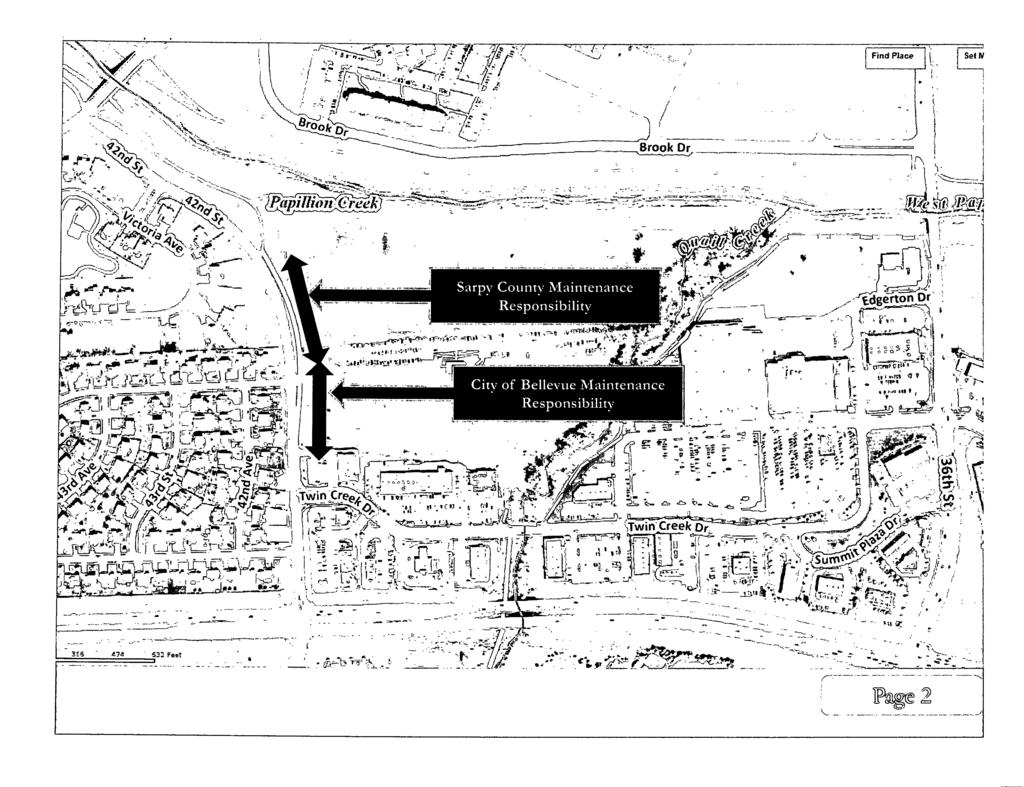
6 The trail will provide pedestrians a safe way to cross Hwy 370 via a new passage under the Highway. The south segment of the trail will connect to neighboring trails, a school and a small lake. Additionally, the trail will connect with the existing Marv Holubar trail and provide access to the Bellevue Soccer Complex, the Twin Creek development, and ultimately connecting to the West Papillion Creek Trail to the north of the Soccer Complex. g. Partnerships - See attachment 13 for map of responsibilities. Sarpy County will partner with the City of Bellevue for the completion of this project and the maintenance of the trail. Sarpy County will be the Fiscal Agent and an Interlocal Agreement will be drafted and signed by both Sarpy County and the City of Bellevue upon approval of funding. The City of Bellevue will contribute $20,000 toward the local match. Sarpy County will contribute the remaining balance of the local match. In addition, the City of Bellevue will be responsible for maintenance of the trail which is within the jurisdiction of Bellevue, Nebraska. The approximate delineation of responsibilities is 900 feet for the City of Bellevue and 3000 feet for Sarpy County. h. Public Controversy - There is no controversy surrounding the development and extension of this trail. All Board meetings are open to the public and documents placed on the internet for public viewing. This grant was up for approval by the Board at the September 2 7, 2011 Sarpy County Board of Commissioners meeting. A copy of the Board Resolution authorizing approval is available upon request. i. Signage - The signage for the trail will be directional and informational. A sign will display the name of the trail and sponsorship recognizing the Recreational Trails Program of the Federal Highway Administration. In addition, there will be signs indicating the direction/location of adjacent trails and the soccer complex. The costs for signage will be the responsibility of Sarpy County and the City of Bellevue. j. Maintenance Plan for 25 years- (see attachment 1) k. Labor hours if using forced account labor - Sarpy County will use a contractor for completion of the project and will request bids according to the State procurement process as required by Federal funding. I. Describe what a user will see and experience on the trail- From the start of this project at the Twin Creek Shopping Center, users of the Holubar Recreational Trail can experience a leisurely ride, run, or walk along the tranquil Quail Creek to the south, a viable access to the Bellevue Soccer Complex for sport and recreation, a connection to the West Papio Trail for a longer trip, or a connection to the paths that run through Lakewood Village or Quail Creek. The characteristics of the trail vary
7 from the more populated shopping and restaurants of Twin Creek to several wooded areas south of Highway The connection to Lakewood Villages, affords the users with a beautiful view of the lower lake, a quiet trail along the upper lake with wildlife in the form of raccoons and water fowl, or a public playground on the far north end. m. Photos- (see attachment 2 for photo explanation and attachments labeled A-L for photos) 2. Site Plan (see attachment 3 and 4) a. Legal boundaries of the trail including section, township and range- (see attachment 5) b. (see attachments 3 and 4). c. Trail route within property - pedestrians and bikers enter the trail from the north or the south segments. d. Scale drawing and show scale- (see attachment 3 and 4). e. North arrow (see attachment 3 and 4). f. Surrounding land uses- (see attachment 3 and 4). g. Abutting Roads- (see attachment 3 and 4). 3. Itemized Cost Estimate- (see attachment 6 for Cost Estimate and attachment 12 for NEP A Scope of Service information) 4. Plat Map- (see attachment 7) 5. Floor Plan -Not applicable. No buildings are planned for the trail. 6. Environmental Documentation- (see attachment 8) 7. Ownership of Land- (see attachment 11 for Surveyor's report and attachment 14 for conversation with NDOR). The trail will run along public right of way except for that portion in Outlot A, Twin Creek Plaza Replat VI and Outlot 1, 3 70 Point. The first property is owned by the City of Bellevue as noted on the attached legal description and the second property is owned by SID 189 and will contain an easement for the trail which will be donated. As noted in the application, this easement will be obtained in accordance with NDOR's Right-of-Way Acquisition Guide for Local Public Agencies and will be obtained within three months of receiving notice ofthe grant award. 8. Resolution- (see attachment 9). 9. Land Acquisition-Land currently owned by SID 189 will contain an easement which will be donated. This easement will be obtained in accordance with NDOR's Right-of-
8 Way Acquisition Guide for Local Public Agencies. This will be obtained within three months of receiving notice ofthe grant award. 10. Easements/Leases- All of the trail will run along public right of way except for that portion in Outlot A, Twin Creek Plaza Replat VI and Outlot 1, 3 70 Point. The first property is owned by the City of Bellevue as noted on the attached legal description and the second property is owned by SID 189 and will contain an easement for the trail which will be donated. As noted in the application, this easement will be obtained in accordance with NDOR's Right-of-Way Acquisition Guide for Local Public Agencies and will be obtained within three months of receiving notice of the grant award. 11. Historical/Cultural Resources- Not applicable. There are no cultural or historical resources near the existing or proposed trails. 12. Local Comprehensive Planning- (see attachment 10). The goal is to extend and develop trails creating continuous non-motorized access through the county. Attachment 10, figure 5.2 indicates the proposed link with the existing Papio Trail and a safe pedestrian passage across Hwy Wetlands- The Sarpy County Engineer has determined that a Section 13 and/or a Section 404 permit may be required pending review by the Army Corps of Engineers. As indicated on the Environmental Review, attachment 8, there is a possibility of wetland involvement. Sarpy County will contact the Army Corps of Engineers to review the proposed plan and conduct wetland delineation. 14. Fish/Wildlife/Plants- Not Applicable, there are no endangered species near the proposed project. Plants near the proposed trail consist of small volunteer trees, native grasses and weeds. 15. Right-Of-Way Certificate - Right of Way Certificate will be signed upon approval of funding prior to construction assuring proper procedure was followed regarding public Right-of-Way within the community. 16. Debarment and Suspension- Certification regarding Debarment, Suspension, Ineligibility and Voluntary Exclusion form will be signed upon approval of funding prior to construction. 17. Trails Dealing with Railroads- Not applicable. There are no railroads present near the existing or proposed trails. 18. Support of the Community- Please see letters of support enclosed with application.
9 ATIACHMENT 1 Revised MAINTENANCE PLAN Marv Holubar Recreational Trail Sarpy County Nebraska Non-Motorized Trail The Marv Holubar Trail will be a 10 feet wide, 5" in depth concrete surface with grass adjacent to each side of the trail. Maintenance activities will be primarily mowing this grass around the trail during the growing season and spraying for noxious weeds as needed, removal of snow and ice during the winter season, trash pick-up along the trail, and any periodic repairs to the surface and signage that may arise throughout the anticipated life expectancy of the trail. Since there are no other facilities associated with the trail such as a trailhead, restrooms, buildings or other facilities, maintenance will be limited to the trail only. Maintenance Activities Trash Removal Snow removal Mowing Trimming trail edges Trailhead/Restroom Inspections Surface repairs Repair/replace signage The maintenance for the proposed Marv Holubar Recreational Trail will be the responsibility of the City of Bellevue for those areas within the jurisdiction of Bellevue, NE and the responsibility of Sarpy County for the segment within Sarpy County Nebraska. The approximate delineation of responsibilities is 900 feet for the City of Bellevue and 3000 feet for Sarpy County. Specifically, the City of Bellevue Parks Maintenance staff will be assigned to maintain Bellevue's portion of the trail and the Sarpy County Public Works Department will be responsible for the maintenance of the Sarpy County portion. Additional support in maintaining the trail may come from volunteers on an as needed basis which can include bicycle and running clubs, non-profit organizations and individuals. The costs of the trail maintenance will be absorbed into the Departments of each agency's annual budget and there are sufficient funds available to do so. The anticipated budget impact should be minimal and is estimated to be approximately $400 per year for Bellevue and $600 per year for Sarpy County.
10 ATIACHMENT6 COST ESTIMATE REVISED DEVELOPMENT of Marv Holubar Trail County of Sarpy and City of Bellevue, Nebraska Item - Unit No. Unit Cost Required Clearing & Grubbing Acre 2 $2000 Earth Work (Cut & Fill) Cubic Yard 1800 $10.39 Trail Surfacing- (indicate type of Linear Foot 4200 $22.50 surface, depth & width) Subgrade Preparation Square 4200 $4.80 Yards Seedinv Acre 1.5 $733 Culverts Linear Foot 24 $50 Bollards Each 4 $400 Bridge (if necessary-include decking, Each n/a n/a railing, length, abutments... etc) Environmentnl Costs (cultural surveys, NEI'A Lump Sum Lump Sum biological survey, soil detennination Review wetland delineation, wetland mitivation... etc) Construction Costs Subtotal Mobilization (I) LumnSum Lump Sum Lump Sum Total Constntction Costs Engineering Costs Design Engineering (Recommend this Lump Sum be used as part of local match) Construction Engineering/Contingency Lump Sum Total Project Costs Funding Sources Private Funding/Donations 0% Forced Account Funding 0% Cash Match from Sponsor 20% Federal Funding 80% - Cost $4,000 s 18,700 $94,500 $20,100 $1,100 $1,200 $1,600 n/a - s 15,000 $156,200 $4,000 $160,200 $30,000 $15,600 $205,800 $0 $0 $41,200 $164,600
11 Nebraska Game and Parks Commission Recreational Trails Program (RTP) Name of Sponsor: Sarpy County Project Name: Development and extension of the Marv Holubar Trail Revised Environmental Review ENVIRONMENTAL REVIEW Review Area '. Estimated Involvement 1 Project on new alignment 0No [8J Yes 10 Don't Know 2 Additional right-of-way required 0No [8J Yes 3 Any railroad crossings [8J No DYes 4 Airport within 112 mile [8J No DYes ON/A 5 Public interest likely to be: [8J Low D Moderate 0High 6 NPDES Permit needed 0No [8J Yes 7 Relocation of persons, businesses, farm. [8J No DYes Est# 8 Any significant stream crossings [8J No DYes 9 Any channel changes required [8J No DYes 10 Section 404 permit required 0No [8J Possible DYes 11 Floodplain permit required 0No [8J Possible DYes 12 Any wetland involvement 0No [8J Possible DYes Review Areas Possible Effect 13 Air Quality [8J None D Minor D Significant 14 Noise Quality [8J None 0Minor D Significant 15 Landscaping 0None [8J Minor D Significant 16 Fish and Wildlife [8J None D Minor D Significant 17 Water Quality/Impacts [8J None 0Minor D Significant 18 Civil Rights (Minority Involvement) [8J None 0Minor D Significant 19 Neighborhood disruption [8J None 0Minor D Significant 20 Schools, churches, cemeteries or hospitals [8J None D Minor D Significant 21 Public health and safety [8J None 0Minor D Significant 22 Economic activity [8J None 0Minor D Significant 23 6(f) land [8J None D Minor D Significant 24 Historic sites [8J None 0Minor D Significant 25 Multiple use of space [8J None 0Minor D Significant 26 Prime farmland or unique farmland [8J None D Minor D Significant Remarks This is a trail within ROW and along a creek. Easements will be necessary. Disturbing more than 1 acre. Work is being done along bank. Limits will dictate if permit is required. Same as Item 10. Any wetlands will be avoided, minimized or mitigated. Some volunteer trees will be removed to make room for the bike path.
12 Dennis L. Wilson P.E. Sarpy County Engineer ' SARPY COUNTY PUBLIC WORKS DEPARTMENT South 84th Street Papillion, Ne Phone (402) FAX (402) October 19, 2011 Lisa A. Haire Sarpy County Grant Coordinator 1210 Golden Gate Drive Papillion, Ne To Whom It May Concern: 1, Louis Whisonant, Deputy Sarpy County Surveyor, do hereby certify that the proposed Marv Holubar Trail will be located in Dedicated Public Right-Of-Way, City of Bellevue property, SID #189 and the Nebraska Department of Roads Highway #370 Right-Of-Way as shown on the attached Exhibit "A". A search of Sarpy County public records confirms that all of 42"d Street, from Hansen Avenue to Highway #370, is owned by Sarpy County and the City of Bellevue. The portion of said Trail going under Highway #370 is owned by the Nebraska Department of Roads and the final portion of said Trail along Maass Road, from 42"d Street to 45th Street is owned by the City of Bellevue and Sarpy County. ~L/L-Y Signed: Louis Whisonant Deputy Sarpy County Surveyor <!2z.n~ 4 ceji,l Dated:
13
14 Attachment #12 Scope of Services for NEPA Documentation Environmental Documentation A. Environmental Determination. Consultant will prepare an Environmental Determination Form and supporting documentation In compliance with the NDOR LPA Manual for Preparing Categorical Exclusions for Local Federal Aid Projects, and in compliance with the National Environmental Policy Act (NEPA), and all applicable State and Federal laws, Executive Orders, and regulations. The Determination Form and supporting documentation will provide a level of analysis commensurate with the level of impact of the proposed action and its alternatives. Sections in the Determination Form include: 1. Project Description, Purpose and Need Statement 2. Right of Way, Relocations, Utility Coordination 3. Section (4f) and Section (6f) 4. Threatened and Endangered Species 5. Wetlands I Waters of the United States I Waters of the State( Title 117) 6. Floodplains 7. Regulated Materials 8. Water Quality 9. Construction Impacts 10. Permitting and Environmental Commitments Consultant will contact various agencies and interested stakeholders, including the U.S. Army Corps of Engineers, Nebraska State Historic Preservation Officers, Nebraska Department of Environmental Quality, Nebraska Department of Natural Resources, Nebraska Game and Parks Commission, And any other applicable agencies, and any other applicable stakeholders. Wetland Delineation. Complete a jurisdictional wetland evaluation of the wetland and waters of the U.D. for the project site. Wetlands indentified during the investigation will be delineated in Accordance with the U.S. Army Corps of Engineers ( COE) 1987 Wetlands Delineation Manual, and wetland boundaries will be Located by sub-meter accuracy GPS in the field. Areas that are not wetlands but meet the definition of "waters of the U.S." will be identified on maps only and not delineated in the field. A wetland report will be prepared documenting the findings. 1
15 Wetland Permitting Assistance. This project is assumed to qualify For a Nationwide Permit ( 404). Complete NEPA forms and support. Prepare Green Sheets and revisions required Storm Water Plan, SWPPP, Federal Aviation Administration (Air Traffic Organization, Obstruction Evaluation Service) 2

16 . - ~ ~ ;;---...,.li.~ - "!.. : ~ -- -_,...,..,.--.-~ '
17
18 ATIACHMENT 14 Access within Nebraska Department of Roads Right of Way Tim Weander from the Nebraska Department of Roads was contacted in August of2011 by phone regarding the Marv Holubar Trail grant application being submitted to the Nebmska Game and Parks Department. The purpose of the phone call was to detem1ine if placing a path underneath the Highway 370 bridge near " Street was feasible under NDOR's cun cnt policies. Mr. Wcandcr stated that Sarpy County or the lead agency for the project would need to submit a Pem1it to Occupy State Right of Way. Since the path is crossing the highway underneath the bridge, there may be stipulations in regnrd to the location ofthe piers and abutments; erosion control measures; and other construction related issues. However. he said that these paths are present in similar types oflocations and would be feasible providing we submitted plans for review to NDOR prior to construction. He said the pennitting process would be a minimum of 30 days and could take as long as 90 days depending on worklond for the department. o/.~?tf/dlzrn,_,.--- Dennis L. Wilson, P.E.
19 Sarpy County Board of Commissioners 1210 GOLDEN GATE DRIVE PAPILLION, NE ADMINISTRATOR Mark Wayne DEPUTY ADMINISTRATOR Scott Bovick FISCAL ADM ln./purchasing AGT. Brian Hanson COMMISSIONERS Rusty Hike District 1 Jim Thompson District 2 Tom Richards District 3 Jim Nekuda District 4 Jim Warren District 5 MEMO TO: Sarpy County Board of Commissioners FROM: Lisa A. Haire RE: Recreational Trails Program Grant Revisions On October 25, 2011, the County Board will be asked to ratify revisions to the grant application and attachments related to the submission of the Recreation Trails Program Grant (RTP) offered through the Nebraska Game and Parks Commission. On October 13, the Nebraska Game and Parks Commission contacted Dennis Wilson via requesting clarification on items relating to Right-of-Way, budget and timeline. The Nebraska Game and Parks Commission asked to receive the revisions no later than October 20, 2011, which did not allow the Sarpy County Engineer sufficient time to get the revisions to the Board prior to submission. In their request, the Nebraska Game and Parks Commission requested Sarpy County change the depth of concrete from 6 inches to 5 inches decreasing the overall cost by $24,000. Please see the revised Budget Attachment and Cost Estimate. The Nebraska Game and Parks Commission also requested clarification on Right-of-Way and asked for a timeline adjustment. Dennis Wilson attached a document indicating he has spoken with Nebraska Department of Roads (NDOR) regarding this project and will be in further contact with NDOR as the project progresses. Additionally, documentation was added from a Surveyor's report on whether the land is the public Right-of-Way, the City's, or NDOR's. Please do not hesitate to contact Dennis Wilson with any questions. October 21, 2011 cc: Mark Wayne Scott Bovick Brian Hanson Dennis Wilson Deb Houghtaling liili-ridj tkuj Lisa A. Haire
BOARD OF COUNTY COMMISSIONERS SARPY COUNTY, NEBRASKA
 ,_ 2011-329 BOARD OF COUNTY COMMISSIONERS SARPY COUNTY, NEBRASKA RESOLUTION AUTHORIZING THE CHAIRMAN TO SIGN THE APPLICATION, LETTER OF SUPPORT, AND OTHER DOCUMENTS RELATING TO THE RECREATIONAL TRAILS
Chapter 4.0 Alternatives Analysis
 Chapter 4.0 Alternatives Analysis Chapter 1 accumulated the baseline of existing airport data, Chapter 2 presented the outlook for the future in terms of operational activity, Chapter 3 defined the facilities
NATIONAL PARK SERVICE CERTIFICATION OF COMPLETED SEGMENTS OF THE NORTH COUNTRY NATIONAL SCENIC TRAIL
 NATIONAL PARK SERVICE CERTIFICATION OF COMPLETED SEGMENTS OF THE NORTH COUNTRY NATIONAL SCENIC TRAIL Completed trail segments that (1) follow the route identified in the 1982 National Park Service (NPS)
TRUCKEE TAHOE AIRPORT DISTRICT BOARD OF DIRECTOR STAFF REPORT
 AGENDA ITEM: 11 TRUCKEE TAHOE AIRPORT DISTRICT BOARD OF DIRECTOR STAFF REPORT AGENDA TITLE: MEETING DATE: January 24, 2018 PREPARED BY: NTPUD Agency Partnership Opportunity, Multi-Use Trailhead Access
Waukee Trailhead Public Art and Amenities Project
 Waukee - Trailhead Public Art and Amenities Project Sponsor Waukee Project Title Waukee Trailhead Public Art and Amenities Project Termini Description ( i.e. Park Avenue to 19th Street) NE Intersection
Rural Rustic Road Program
 Virginia Department of Transportation s Rural Rustic Road Program Prepared by the Local Assistance Division Virginia Department of Transportation 1401 East Broad Street Richmond, Virginia 23219 Michael
Environment and Natural Resources Trust Fund (ENRTF) M.L ENRTF Work Plan (Main Document)
 M.L ENRTF Work Plan (Main Document)") Environment and Natural Resources Trust Fund (ENRTF) M.L. 2018 ENRTF Work Plan (Main Document) Today s Date: December 8, 2017 Date of Next Status Update Report: January 31, 2019 Date of Work Plan Approval:
Environment and Natural Resources Trust Fund (ENRTF) M.L. 2018 ENRTF Work Plan (Main Document) Today s Date: December 8, 2017 Date of Next Status Update Report: January 31, 2019 Date of Work Plan Approval:
Trail # NW Tuesday, June DESIGN. Provide an Review the Provide an. Project Goals: System system. wayfinding
 I. Welcome / Introductions Bethany Creek Trail #2 Segment 3 Neighborhood Meeting #1 Bethany Presbyterian Church 15505 NW Springville Road, Portland, OR 97229 Tuesday, June 26, 2018 @ 6:00PM Meeting Minutes
2. Goals and Policies. The following are the adopted Parks and Trails Goals for Stillwater Township:
 D. PARKS AND TRAILS 1. Introduction Stillwater Township s population is relatively low, with most residents living on rural residences on large lots. The need for active park space has been minimal in
AGENDA ITEM 5 D WAKULLA ENVIRONMENTAL INSTITUTE (WEI) TRAIL FEASIBILITY STUDY
 TRAIL FEASIBILITY STUDY") March 19, 2018 AGENDA ITEM 5 D WAKULLA ENVIRONMENTAL INSTITUTE (WEI) TRAIL FEASIBILITY STUDY TYPE OF ITEM: Action STATEMENT OF ISSUE The Wakulla Environmental Institute (WEI) Trail is one of several trails
March 19, 2018 AGENDA ITEM 5 D WAKULLA ENVIRONMENTAL INSTITUTE (WEI) TRAIL FEASIBILITY STUDY TYPE OF ITEM: Action STATEMENT OF ISSUE The Wakulla Environmental Institute (WEI) Trail is one of several trails
City of Durango 5.8 FUNDING TRAILS DEVELOPMENT
 5.8 FUNDING TRAILS DEVELOPMENT The City has been successful in establishing dedicated local funding sources as well as applying for grants to develop the City s trail system, having received nearly $2.4
U.S. Army Corps of Engineers Fiscal Year 2013 Handshake Program Application
 U.S. Army Corps of Engineers Fiscal Year 2013 Handshake Program Application Please review instructions before completing application! Corps Lake/Project Name:Rathbun Lake/ North Shore Trail Handshake Proposal
FEASIBILITY CRITERIA
 This chapter describes the methodology and criteria used to evaluate the feasibility of developing trails throughout the study areas. Land availability, habitat sensitivity, roadway crossings and on-street
Rule Governing the Designation and Establishment of All-Terrain Vehicle Use Trails on State Land
 Rule Governing the Designation and Establishment of All-Terrain Vehicle Use Trails on State Land 1.0 Authority 1.1 This rule is promulgated pursuant to 23 V.S.A. 3506. Section 3506 (b)(4) states that an
CITY COUNCIL AGENDA MEMORANDUM
 To: Mayor and City Council From: Charles Ozaki, City and County Manager Prepared By: Kevin Standbridge, Deputy City and County Manager Katie Allen, City and County Engineer David Shinneman, Community Development
DECISION MEMO. Rawhide Trail #7073 Maintenance and Reconstruction
 Page 1 of 6 Background DECISION MEMO USDA Forest Service Jefferson Ranger District Jefferson County, Montana Rawhide Trail #7073 is located in the Elkhorn Mountain Range approximately 10 miles east of
PULLMAN-MOSCOW REGIONAL AIRPORT Runway Realignment Project
 PULLMAN-MOSCOW REGIONAL AIRPORT Runway Realignment Project GENERAL AIRPORT INFORMATION AIRPORT USERS Airport ownership: Public, owned by the Pullman-Moscow Regional Airport Board Year opened: February
Daisy Dean Trail 628/619 ATV Trail Construction
 Background and Purpose and Need The Daisy Dean ATV Trail Construction Project is located in the Little Belt Mountains, Musselshell Ranger District, Lewis and Clark National Forest approximately 32 miles
RESOLUTION NO
 RESOLUTION NO. 2015-15 A RESOLUTION OF THE CITY COUNCIL OF THE CITY OF MARINA AUTHORIZING SUBMISSION OF A GRANT APPLICATION TO THE FEDERAL AVIATION ADMINISTRATION (FAA) FOR PARTICIPATION IN THE 2015 MILITARY
White Mountain National Forest Saco Ranger District
 United States Department of Agriculture Forest Service White Mountain National Forest Saco Ranger District 33 Kancamagus Highway Conway, NH 03818 Comm: (603) 447-5448 TTY: (603) 447-3121 File Code: 1950
Bear Creek Habitat Improvement Project
 06/10/10 Bear Creek Habitat Improvement Project El Paso County, Colorado Pike National Forest and Colorado Springs Utilities Owned Land Report prepared by: Eric Billmeyer Executive Director Rocky Mountain
Trails Technical Committee
 Trails Technical Committee Winter 2017 Draft Report Alignment Proposals for the Inyo National Forest and the Town of Mammoth Lakes Map ID #S18 February 08, 2017 Map ID #S18 Key Agreements As of February
Bradley Brook Relocation Project. Scoping Notice. Saco Ranger District. United States Department of Agriculture Forest Service
 Bradley Brook Relocation Project United States Department of Agriculture Forest Service Scoping Notice White Mountain National Forest February 2011 For Information Contact: Jenny Burnett White Mountain
DRAFT - APRIL 13, 2007 ROUTING STUDY FOR TRAIL CONNECTIONS BETWEEN CALAIS AND AYERS JUNCTION
 DRAFT - APRIL 13, 2007 ROUTING STUDY FOR TRAIL CONNECTIONS BETWEEN CALAIS AND AYERS JUNCTION Abstract The vision for the East Coast Greenway is an off-road urban trail system running from Calais, Maine
Project Summary 2009
 Project Summary 2009 SB-2009-MN-55360: Lady Slipper Scenic Byway Pedestrian Walkway State Submission Date not submitted Division Submission Date not submitted State Priority 0 This application must be
Environment and Natural Resources Trust Fund 2019 Request for Proposals (RFP)
") Environment and Natural Resources Trust Fund 2019 Request for Proposals (RFP) Project Title: Glacial Edge Trail and Downtown Pedestrian Bridge Category: G. Land Acquisition for Habitat and Recreation ENRTF
Environment and Natural Resources Trust Fund 2019 Request for Proposals (RFP) Project Title: Glacial Edge Trail and Downtown Pedestrian Bridge Category: G. Land Acquisition for Habitat and Recreation ENRTF
METROPOLITAN COUNCIL 390 North Robert Street, St. Paul, MN Phone (651) TDD (651)
 TDD (651)") DATE: March 27, 2012 METROPOLITAN COUNCIL 390 North Robert Street, St. Paul, MN 55101 Phone (651) 602-1000 TDD (651) 291-0904 TO: Metropolitan Parks and Open Space Commission FROM: Arne Stefferud, Planning
DATE: March 27, 2012 METROPOLITAN COUNCIL 390 North Robert Street, St. Paul, MN 55101 Phone (651) 602-1000 TDD (651) 291-0904 TO: Metropolitan Parks and Open Space Commission FROM: Arne Stefferud, Planning
White Mountain National Forest Saco Ranger District
 United States Department of Agriculture Forest Service White Mountain National Forest 33 Kancamagus Highway Conway, NH 03818 Comm: (603) 447-5448 TTY: (603) 447-3121 File Code: 1950 Date: February 26,
MORGAN CREEK GREENWAY Final Report APPENDICES
 APPENDICES MORGAN CREEK GREENWAY Appendix A Photos of Existing Conditions in Trail Corridor Photos of existing conditions Main trail corridor - February 2009 Photos of existing conditions south bank Morgan
Trail Feasibility Study
 VOLUSIA COUNTY MPO CITY OF NEW SMYRNA BEACH FINAL REPORT JUNE 30, 2009 Trail Feasibility Study What s inside? 1 Introduction 2 Project Purpose & Scope 3 Physical Inventory & Assessment of Right-of- Way
SECTION 106 ACTIVITIES ANNUAL REPORT
 SECTION 106 ACTIVITIES ANNUAL REPORT FOR THE YEAR ENDING DECEMBER 31, 2014 Metropolitan Washington Airports Authority 198 Van Buren Street, Suite 300 Herndon, Virginia 20170 JANUARY 2015 Introduction The
Classifications, Inventory and Level of Service
 Classifications, Inventory and Level of Service Section 3 Kenmore Park, Recreation and Open Space Plan 1 P a g e Classifications and Inventory Park Classifications Kenmore classifies its parks based upon
Business Item No XXX. Proposed Action That the Metropolitan Council approve the Coon Creek Regional Trail Master Plan.
 Business Item No. 2015-XXX Metropolitan Parks and Open Space Commission Meeting date: July 7, 2015 For the Community Development Committee meeting of July 20, 2015 For the Metropolitan Council meeting
PLANNING COMMISSION AGENDA REPORT May 10, Members of the Planning Commission. Joyce Parker-Bozylinski, Contract Planner
 PLANNING COMMISSION AGENDA REPORT May 10, 2007 TO: FROM: PROPOSAL: APPLICANT: RECOMMENDATION: Members of the Planning Commission Joyce Parker-Bozylinski, Contract Planner Approval of the Calabasas Trails
Blue River Trail Master Plan JSA to Town Hall June 2004
 Blue River Trail Master Plan JSA to Town Hall June 2004 Prepared for: Silverthorne Town Council Silverthorne SPORT Committee Department of Recreation and Culture Silverthorne Public Works Silverthorne
Continental Divide National Scenic Trail Legislative History and Planning Guidance
 Continental Divide National Scenic Trail Legislative History and Planning Guidance Legislation, Policy, and Direction Regarding National Scenic Trails The National Trails System Act, P.L. 90-543, was passed
METROPOLITAN COUNCIL 390 North Robert Street, St. Paul, MN Phone (651) TDD (651)
 TDD (651)") METROPOLITAN COUNCIL 390 North Robert Street, St. Paul, MN 55101 Phone (651) 602 1000 TDD (651) 291 0904 DATE: June 19, 2007 TO: Metropolitan Parks and Open Space Commission FROM: Jan Youngquist, Senior
METROPOLITAN COUNCIL 390 North Robert Street, St. Paul, MN 55101 Phone (651) 602 1000 TDD (651) 291 0904 DATE: June 19, 2007 TO: Metropolitan Parks and Open Space Commission FROM: Jan Youngquist, Senior
CHAPTER III: TRAIL DESIGN STANDARDS, SPECIFICATIONS & PERMITS
 CHAPTER III Trail Design Standards, Specifications & Permits This chapter discusses trail standards, preferred surface types for different activities, permits, and other requirements one must consider
Kelly Motorized Trails Project Proposed Action
 Kelly Motorized Trails Project Proposed Action November 28, 2011 The Flagstaff Ranger District of the Coconino National Forest is seeking public input on the proposed Kelly Motorized Trails Project (formerly
Community Development Committee
 C Community Development Committee For the Metropolitan Council meeting of October 31, 2012 Committee Report Item:2012-316 ADVISORY INFORMATION October 16, 2012 Date Prepared: Subject: Intercity Regional
DRAFT GENERAL IMPLEMENTATION PLAN AND SPECIFIC IMPLEMENTATION PLAN MIDDLETON MUNICIPAL AIRPORT MOREY FIELD. Revised 12/12/03
 DRAFT GENERAL IMPLEMENTATION PLAN AND SPECIFIC IMPLEMENTATION PLAN MIDDLETON MUNICIPAL AIRPORT MOREY FIELD Revised 12/12/03 As recommended for approval by the Plan Commission General Project Description
Decision Memo Ice Age Trail Improvement (CRAC 37)
") Decision Memo Ice Age Trail Improvement (CRAC 37) U.S. Forest Service Chequamegon-Nicolet National Forest, Medford-Park Falls Ranger District Taylor County, Wisconsin T32N, R2W, Town of Grover, Section
Decision Memo Ice Age Trail Improvement (CRAC 37) U.S. Forest Service Chequamegon-Nicolet National Forest, Medford-Park Falls Ranger District Taylor County, Wisconsin T32N, R2W, Town of Grover, Section
Decision Memo Broken Wheel Ranch Equestrian Outfitter Special-Use Permit Proposed Action
 Decision Memo Broken Wheel Ranch Equestrian Outfitter Special-Use Permit USDA Forest Service Mississippi Bluffs Ranger District, Shawnee National Forest Jackson and Union Counties, Illinois Proposed Action
Business Item No
 Metropolitan Parks and Open Space Commission Meeting date: February 6, 2018 For the Community Development Committee meeting of February 20, 2018 For the Metropolitan Council meeting of February 28, 2018
DECISION MEMO North Zone (Legacy Trails) Trail Stabilization Project
 Trail Stabilization Project") DECISION MEMO North Zone (Legacy Trails) Trail Stabilization Project USDA FOREST SERVICE Rocky Mountain Region (R2) Shoshone National Forest Wapiti and Greybull Ranger District Park County, Wyoming Background
DECISION MEMO North Zone (Legacy Trails) Trail Stabilization Project USDA FOREST SERVICE Rocky Mountain Region (R2) Shoshone National Forest Wapiti and Greybull Ranger District Park County, Wyoming Background
Airport Master Plan Update June 15, 2017
 Airport Master Plan Update June 15, 2017 www.harveyfield.com The Master Plan is a 20-year plan to understand the needs of current and future users of the Airport. This is important to ensure that safe
Airport Master Plan Update June 15, 2017
 Airport Master Plan Update June 15, 2017 www.harveyfield.com The Master Plan is a 20-year plan to understand the needs of current and future users of the Airport. This is important to ensure that safe
BOARD OF AIRPORT COMMISSIONERS
 1 8/17/2018 8/21/2018 8/16/2018 i ElY MY Y I : JH MT BY...01,, III1*.ji,"1.111Los Angeles World Airports REPORT TO THE BOARD OF AIRPORT COMMISSIONERS Meeting Date: la Approved by: e1. "ampbell, Chief Airports
Appendix 3. Greenway Design Standards. The Whitemarsh Township Greenway Plan
 Appendix 3 Greenway Design Standards This chapter discusses two design standards for the greenway types discussed above. First, trail design standards are presented together with trailhead facilities and
National Forests and Grasslands in Texas
 United States Department of Agriculture Forest Service National Forests and Grasslands in Texas Sam Houston NF 394 FM 1375 West New Waverly, Texas 77358 Phone 936-344-6205 Dear Friends, File Code: 1950
Community Development
 Community Development City & Borough of Juneau Community Development 155 S. Seward Street Juneau, AK 99801 (907) 586 0715 Phone (907) 586 4529 Fax DATE: February 11, 2016 TO: FROM: Planning Commission
Allegan County Board of Commissioners
 Allegan County Board of Commissioners County Services Building 3283 122 nd Avenue Allegan, MI 49010 269-673-0203 Main Office 269-686-5331 Main Fax http://www.allegancounty.org Dean Kapenga, Chairman Tom
WASHINGTON STATE PARKS AND RECREATION COMMISSION POLICY/PROCEDURE
 WASHINGTON STATE PARKS AND RECREATION COMMISSION POLICY/PROCEDURE 65-13-1 Use of Other Power-Driven Mobility Devices by Persons with Mobility Disabilities at State Park Facilities See Also: 28 CFR 35 Title
Draft Concept Alternatives Analysis for the Inaugural Airport Program September 2005
 Draft Concept Alternatives Analysis for the Inaugural Airport Program September 2005 Section 3 - Refinement of the Ultimate Airfield Concept Using the Base Concept identified in Section 2, IDOT re-examined
Segment 2: La Crescent to Miller s Corner
 goal of the USFWS refuges is to conserve, protect and enhance fish, wildlife and plants and their habitats for the continuing benefit of the American people. Refuge lands are used largely for fishing,
Understanding user expectations And planning for long term sustainability 1
 Understanding user expectations And planning for long term sustainability 1 What is a natural surface trail? It can be as simple has a mineral soil, mulched or graveled pathway, or as developed as elevated
COASTAL CONSERVANCY. Staff Recommendation September 22, 2011 BAY AREA RIDGE TRAIL: HOOD MOUNTAIN TO HIGHWAY 12
 COASTAL CONSERVANCY Staff Recommendation September 22, 2011 BAY AREA RIDGE TRAIL: HOOD MOUNTAIN TO HIGHWAY 12 File No. 11-039-001 Project Manager: Betsy Wilson RECOMMENDED ACTION: Authorization to disburse
AGENCY SCOPING MEETING
 AGENCY SCOPING MEETING Environmental Impact Statement (EIS) Conducted for the Friedman Memorial Replacement Airport in the Wood River Region of South Central Idaho December 4, 2007 1:00 p.m. 4:00 p.m.
The Chu property is a 6.57 acre parcel located in the Town of Superior on the west side of McCaslin Boulevard. In 2014, the Town of Superior acquired
 1 The Chu property is a 6.57 acre parcel located in the Town of Superior on the west side of McCaslin Boulevard. In 2014, the Town of Superior acquired the Chu property for open space with a contribution
Aspen Skiing Company Policy for Use of Other Power-Driven Mobility Devices And Service Animals
 Aspen Skiing Company Policy for Use of Other Power-Driven Mobility Devices And Service Animals Introduction New rules under the Americans with Disabilities Act (ADA), Titles II and III, went into effect
MONTEREY REGIONAL AIRPORT MASTER PLAN TOPICAL QUESTIONS FROM THE PLANNING ADVISORY COMMITTEE AND TOPICAL RESPONSES
 MONTEREY REGIONAL AIRPORT MASTER PLAN TOPICAL QUESTIONS FROM THE PLANNING ADVISORY COMMITTEE AND TOPICAL RESPONSES Recurring topics emerged in some of the comments and questions raised by members of the
Section II. Planning & Public Process Planning for the Baker/Carver Regional Trail began in 2010 as a City of Minnetrista initiative.
 Section II Planning & Public Process Planning for the began in 2010 as a City of initiative. city staff began discussions with the Park District on the possibility of a north/south regional trail connection
Project Planning, Compliance, and Funding
 Project Planning, Compliance, and Funding The plans above offer high level guidance to ensure that the A.T. is managed effectively as a whole unit in a decentralized management structure. Cooperative management
Emily to Blind Lake Trail PROPOSED TRAIL DEVELOPMENT APPLICATION SUMMARY
 Emily to Blind Lake Trail PROPOSED TRAIL DEVELOPMENT APPLICATION SUMMARY Township 137 Range 26 (Fairfield Township) sections 2 & 3 Township 138 Range 26 (City of Emily) sections 27, 34, 35, & 36 Township
Blueways: Rivers, lakes, or streams with public access for recreation that includes fishing, nature observation, and opportunities for boating.
 Parks, Open Space and Trails PRINCE WILLIAM COUNTY 2008 COMPREHENSIVE PLAN TRAILS PLAN CONTENTS The components of the trails plan are: Intent Definitions Goals, Policies, and Action Strategies Trails Map
For Airport Environmental Services. Date Released: August 27, 2018 Deadline for Submission: 5:00pm, September 17, 2018
 COUNTY OF INYO REQUEST FOR QUALIFICATIONS For Airport Environmental Services Date Released: August 27, 2018 Deadline for Submission: 5:00pm, September 17, 2018 County of Inyo Public Works Department P.O.
Decision Memo for Desolation Trail: Mill D to Desolation Lake Trail Relocation
 for Salt Lake County, Utah Uinta-Wasatch-Cache National Forest Salt Lake Ranger District 1. Background The present location of the Desolation Trail (#1159) between Mill D and Desolation Lake follows old
Georgetown-Lewes Rail/Trail Study. Rail/Trail Study: Cool Spring to Cape Henlopen State Park New Road Extension (House Resolution No.
 Georgetown-Lewes Rail/Trail Study Rail/Trail Study: Cool Spring to Cape Henlopen State Park New Road Extension (House Resolution No. 47) August 22, 2011 Presentation Outline Background Benefits Statewide
BACKCOUNTRY TRAIL FLOOD REHABILITATION PROGRAM
 BACKCOUNTRY TRAIL FLOOD REHABILITATION PROGRAM Backcountry Trail Flood Rehabilitation A June 2013 Flood Recovery Program Summary In June 2013, parts of Southern Alberta were devastated from significant
Committee Report. Community Development Committee For the Metropolitan Council meeting of August 12, Business Item No.
 Committee Report Business Item No. 2015-168 Community Development Committee For the Metropolitan Council meeting of August 12, 2015 Subject: Coon Creek Regional Trail Master Plan, Anoka County Proposed
White Mountain National Forest
 White Mountain National Forest United States Department of Agriculture Forest Service Eastern Region Boles Brook Snowmobile Bridge Decision Memo Boles Brook Snowmobile Bridge Project Town of Woodstock
Public Notice ISSUED: December 10, 2018 EXPIRES: January 9, 2019
 APPLICANT: REFER TO: St. Louis and Lake Counties Regional Rail Authority 2018-01942-ARC Public Notice ISSUED: December 10, 2018 EXPIRES: January 9, 2019 SECTION:404 - Clean Water Act 1. APPLICATION FOR
June 16, Sarpy County Board of Commissioners Sarpy County Courthouse 1210 Golden Gate Drive Papillion, Nebraska 68046
 SARPY COUNTY Department of Planning & Building Sarpy County Courthouse Annex 1261 Golden Gate Drive, Suite 2E Papillion, Nebraska 68046 Phone (402) 593-2156 - Fax (402) 593-4335 Ken Tex, Planning & Zoning
ACTION TRANSMITTAL
 Transportation Advisory Board of the Metropolitan Council of the Twin Cities ACTION TRANSMITTAL 2018-16 DATE: February 9, 2018 TO: Transportation Advisory Board FROM: Technical Advisory Committee PREPARED
Port MacKenzie Rail Extension
 Port MacKenzie Rail Extension Project The Matanuska-Susitna Borough (MSB) and the Alaska Railroad Corporation (ARRC) jointly propose construction and operation of a new rail line to connect the Borough
CHAPTER 4 -- THE LAND USE PLAN: DESCRIPTIONS AND POLICIES FOR THIRTEEN PLANNING AREAS
 CHAPTER 4 -- THE LAND USE PLAN: DESCRIPTIONS AND POLICIES FOR THIRTEEN PLANNING AREAS NORTH CENTRAL CAC AREA LITTLE VALLEY ROAD TO JUG HANDLE CREEK PLANNING AREA This planning area includes Cleone, Noyo,
Tallahassee-St. Marks Historic Railroad Trail
 Revitalizing a Historic Trail Designated as a National Recreation Trail, the 16-mile Tallahassee-St. Marks Historic Railroad Trail has been enjoyed by countless bicyclists, runners, and outdoor enthusiasts
Creating a User-Driven Long-Distance OHV Trail Through Partnering
 Joseph Raffaele Outdoor Recreation Planner U.S. Bureau of Land Management Yuma, Arizona Creating a User-Driven Long-Distance OHV Trail Through Partnering BLM is a multiple-use land management agency within
4.19 Parks, Recreation, and Conservation Lands
 interchange would have on the Reed Paige Clark Homestead located on the north side of Stonehenge Road. Alternative D would also affect Palmer Homestead, E.F. Adams House, and Knapp Brothers Shoe Manufacturing
Auburn Trail / Ontario Pathways Trail Connector Feasibility Study Public Information Meeting Wednesday, August 22, 2012
 Auburn Trail / Ontario Pathways Trail Connector Feasibility Study Public Information Meeting Wednesday, August 22, 2012 Purpose of Feasibility Study Purpose Evaluate the feasibility of constructing a multiuse
MUNICIPALITY OF ANCHORAGE
 MUNICIPALITY OF ANCHORAGE ANCHORAGE PARKS & RECREATION Memorandum PRC 08-56 DATE: 5 August 2008 TO: FROM: SUBJECT: Parks & Recreation Commission Holly Spoth-Torres, Park Planner PRC 08-56 Far North Bicentennial
U.S. Army Corps of Engineers Fiscal Year 2017 Handshake Program Application
 U.S. Army Corps of Engineers Fiscal Year 2017 Handshake Program Application Please review instructions before completing application! Corps Lake/River Project Name: Pearson Skubitz Big HIll Lake District
Agenda Report. Spruce Street Outlet Drainage Improvements Tower Road Relief Sewer
 Agenda Report Subject: Prepared By: Spruce Street Outlet Drainage Improvements Tower Road Relief Sewer Steven M. Saunders, Director of Public Works/Village Engineer Date: August 12, 2012 On March 8, 2012
Flow Stand Up Paddle Board Parkway Plan Analysis
 Regional Parks Department Jeffrey R. Leatherman, Director County of Sacramento Divisions Administration Golf Leisure Services Maintenance Rangers Therapeutic Recreation Services Flow Stand Up Paddle Board
Port MacKenzie Rail Extension
 Port MacKenzie Rail Extension Project The Matanuska-Susitna Borough (MSB) and the Alaska Railroad Corporation (ARRC) jointly propose construction and operation of a new rail line to connect the Borough
City of Lafayette. Request for Proposals Municipal Airport Fixed Based Operator
 City of Lafayette Request for Proposals Municipal Airport Fixed Based Operator NOTICE PROPOSERS The City of Lafayette is seeking an experienced, reliable professional to establish and operate a fullservice
S Central Coast Heritage Protection Act APRIL 21, 2016
 STATEMENT OF GLENN CASAMASSA ASSOCIATE DEPUTY CHIEF, NATIONAL FOREST SYSTEM U.S. FOREST SERVICE U.S. DEPARTMENT OF AGRICULTURE BEFORE THE UNITED STATES SENATE COMMITTEE ON ENERGY AND NATURAL RESOURCES
County of Sonoma Agenda Item Summary Report
 Revision No. 20170501-1 of Sonoma Agenda Item Summary Report Agenda Item Number: 37 (This Section for use by Clerk of the Board Only.) Clerk of the Board 575 Administration Drive Santa Rosa, CA 95403 To:
Chapter 2: Summary of Existing Open Space System
 Chapter 2: Summary of Existing Open Space System In 1976, the Wake County Board of Commissioners established the Wake County Parks and Recreation Department in order to provide park facilities and programs
Sevierville, TN. Technical Appendices
 Sevierville, TN Technical Appendices 2017 2955 Valmont Road Suite 300 777 North Capitol Street NE Suite 500 Boulder, Colorado 80301 Washington, DC 20002 n-r-c.com 303-444-7863 icma.org 800-745-8780 Contents
Preferred Recreation Recommendations Stemilt-Squilchuck Recreation Plan March 2018
 Preferred Recreation Recommendations Stemilt-Squilchuck Recreation Plan March 2018 Below are the recommended recreation ideas and strategies that package together the various recreation concepts compiled
The following criteria shall be applied within the boundaries of the AO District:
 Sec. 419 (a) Purpose AIRPORT OVERLAY DISTRICT (AO) The purpose of the Airport Overlay District is to regulate and restrict the height of structures, objects, or natural growth, regulate the locations of
Virginia Department of Transportation s Rural Rustic Road Program
 Virginia Department of Transportation s Rural Rustic Road Program Prepared by the Local Assistance Division Virginia Department of Transportation 1401 East Broad Street Richmond, Virginia 23219 Michael
CHAPTER 5. Chapter 5 Recreation Element
 CHAPTER 5 Recreation Element Chapter 5 Recreation Element The Recreation Element of the Meyers Area Plan is a supplement to the Recreation Element of the TRPA Regional Plan and the El Dorado County General
EAST DON TRAIL ENVIRONMENTAL ASSESSMENT. Community Liaison Committee Meeting #3 July 15, :30 to 8:30 pm Flemingdon Park Library
 EAST DON TRAIL ENVIRONMENTAL ASSESSMENT Community Liaison Committee Meeting #3 July 15, 2013 6:30 to 8:30 pm Flemingdon Park Library Agenda 1. Welcome 2. Housekeeping and Updates a) Housekeeping b) CLC
BOARD OF EQUALIZATION SARPY COUNTY, NEBRASKA RESOLUTION SETTING LEVY OF TAXES
 201D- 335 BOARD OF EQUALIZATION SARPY COUNTY, NEBRASKA RESOLUTION SETTING 2010-2011 LEVY OF TAXES WHEREAS, by virtue of Neb. Rev. Stat. Sec. 77-1601 (Reissue 2009), the Board is required by law to levy
I. COMMUNICATIONS II. RESOLUTIONS, MOTIONS AND NOTICES
 AGENDA Aviation Committee May 23, 2016 7:00 PM I. COMMUNICATIONS II. RESOLUTIONS, MOTIONS AND NOTICES 1. Resolution authorizing agreement with McFarland Johnson on behalf of the Elmira Corning Regional
COMMUNITY MEETING NOVEMBER 1, Wheaton Regional Park Pine Lake Trail
 COMMUNITY MEETING NOVEMBER 1, 2012 MEETING AGENDA I. Introduction of Project Team II. Trail Renovation Process III. Wheaton Regional Park IV. Pine Lake Trail Renovation Project V. Comments and Questions
Proposed Action. Payette National Forest Over-Snow Grooming in Valley, Adams and Idaho Counties. United States Department of Agriculture
 United States Department of Agriculture Forest Service January 2012 Proposed Action Payette National Forest Over-Snow Grooming in Valley, Adams and Idaho Counties Payette National Forest Valley, Adams
Rogue River Access and Management Plan Draft Alternatives
 Rogue River Access and Management Plan Draft Alternatives The Rogue River Access and Management Plan was initiated in December, 2011 and is being led by Jackson County Parks (JCP) and Oregon Department