Girdwood. Boundaries and Gateways: History:
|
|
|
- Reginald Branden Berry
- 6 years ago
- Views:
Transcription
1 Girdwood Boundaries and Gateways: Located along the southern edge of the Municipality, Girdwood straddles the mouth of Glacier Creek. Of the towns along Turnagain Arm Girdwood has the highest population, though like most resort towns, most residents are not permanent. The Alyeska Highway connects the old town and Seward Highway with Alyeska Resort. Additional points of interest exist, including Crow Creek Pass Trail and local eateries. The major boundaries are the Chugach State Park to the North and East, and Turnagain Arm to the South and West. The Alaska Railroad and Seward Highways act as gateways. Hiking and fishing are very popular in the region, as well as biking and skiing. History: The Turnagain chapter has an expanded history of the rest of the Arm. This section relates specifically to the Glacier Valley and Glacier City, later Girdwood. Prehistory The Dena ina call Turnagain Arm Tutl uh, or Backwater because it was the headwaters of Cook Inlet. Its swift and large tides cause destructive bore tides, which the Dena ina call the nudidghu. They took care when boating down the Arm except harvest fish and berries. Kari found no recorded prehistoric names for the Glacier Valleys, although early surveys suggest trails through the valleys and mountains from Tutl uh (Sunrise/Hope) to Iglughet (Knik). European Exploration Russian and European explorers made only a handful of voyages into the upper Cook Inlet, but learnt of trade routes and place names from the natives living there. Gold Rush After discovery of gold in Resurrection and Six Mile Creeks on the South shore of the Arm in 1895 prospectors rushed to the area from Seward, then the main port for the Territory. Trails snaked from Seward to Anchorage, through the mountains and along Turnagain Arm. Glacier City, now Girdwood, began sometime after Sunrise and Hope in the Glacier Valley on the North side of the Arm, as more prospectors arrived to mine the Crow, California, and Winner Creeks. Homesteaders and prospectors in the Indian and Crow Creek Valleys discovered gold, and installed placer mines. Crow Creek, mined since 1896, had the only profitable mines on the North side of the Arm, and produced ounces of gold in the early 20 th century. The two major mines were the Monarch lode mine near Crow Creek Pass and the Crow Creek placer mine in the valley, the first was the largest and the second the most profitable. Crow Creek Mine and the Girdwood Mining Company s placer mine farther down the valley still produce gold, but remnants and ruins of the former mines exist along Crow Creek Trail. Around 1900, Axel Linblad extended the Kelly Trail from Twentymile River to his mining claims on Winner Creek, near then-glacier City. The National Historic Iditarod Trail snakes through the lower Turnagain Arm region. A portion of the trail from Portage to then-glacier City was substantial by the early 1900s. The trail split at then- Glacier City with one section ascending Crow Pass and the other continuing to Indian. Travel over Crow Creek Pass was infrequent before The difficult terrain spurred the Road Commission to reroute the trail over Crow Pass and improve the road. Nevertheless, avalanches often blocked the trail, making the Indian Creek Pass more popular.
2 The town grew with more prospectors arriving by trail or boat. Originally, it had an informal layout of streets, but the 1916 platting of the town formalized the streets and properties. All buildings were wood-framed or log. The creek that ran through the town went by several names, which may lend a degree of confusion for the histories of Turnagain Arm. Early maps refer to the creek as Twenty mile, not the contemporary Glacier. The Alaska Central Railroad operated a supply store, even though the tracks ended at Kern Creek, four miles to the South. Colonel James Girdwood was successful on his Crow Creek mines, started in 1900, but struggled with the rough terrain and rocky conditions. After his success, in 1907 the town name changed in his honor. Infrastructure Development The Alaska Engineering Commission platted the informal town in 1916 while completing the railroad link to Seward in 1918, passing along the North edge of Glacier City town site. Girdwood was important to the railroad construction, but its proximity to the mining town was a hindrance to workmen s sobriety and efficiency. The Girdwood Section House stood along the tracks just West of the old town site from 1940 until Originally, the one-storey building was at the maintenance Section at Kern Creek, and likely was constructed in The building housed crewman and a foreman or the foreman and his family, as was likely for the Girdwood building until the 1980s. Good Friday Earthquake (Effects of the Earthquake) In March 1964, the Good Friday (or Great Alaskan) Earthquake forever changed the Turnagain landscape. Because of the geology of Glacier Valley, the land subsided an additional three feet to the general 5 feet of subsidence. Although no tsunami moved up Turnagain Arm, the subduction allowed a tidal surge to inundate low areas, especially at Portage. The 9.2 quake destroyed the Seward Highway and Alaska Railroad, and flooded the towns of Girdwood and Portage. The quake triggered landslides and avalanches. Open ground fissures spewed water and mud as the soil shifted. The Southern half of the Girdwood Town site sank into the mud, as did the new Highway. The ground movement twisted the railroad lines, as well. The shaking caused little damage, but a consequent fire destroyed some structures. After the earthquake, residents moved some buildings to higher ground, including the Crow Creek Mercantile, and a new town was platted farther up the valley. Modern Era Girdwood today is mostly a resort town today. The expansion of the Alyeska Ski Resort and Hotel attracts skiers from the Municipality and Outside. The resort began in 1956 with 160 acres at the base of Mt Alyeska. Ernie Baumann, a WWII 10 th Mountain Division veteran, selected the site, then unnamed, for a resort. In the land auction on 4 June 1956, a different corporation, the Alyeska Ski Corp., outbid Baumann s Mountain Sports Development Corp. Alyeska adapted its name from the Aleut word for Alaska, Alaxsxag. François de Gunzburg, a French aristocrat, provided additional funding to the corporation to keep the resort solvent. With those funds, the corporation built trails, Chair 1, and a day lodge by The Roundhouse opened soon after at the top of Chair 1. Local architect Edward Gendzwill designed the iconic summit structure in 1960, and in 2003 it received listing on the National Register of Historic Places. To raise funds for the resort, Gunzburg bought additional lands and subdivided them, prompting resort-related and commercial growth. The Double Musky opened in Through the 1960s, 70s, and 80s Alyeska hosted several national and international alpine skiing events. Yoshiaki Tsutsumi, owner of the Japanese leisure company Seibu Group, bought the resort in 1980 from Chris von Imhof. The Group invested heavily in development of the resort, planning a hotel, tram, and other amenities. The tram opened in 1992, and the hotel opened in Hiking and biking trails developed along creeks and former mining roads. Recently, Alyeska has become popular with downhill bikers. The original alignment of the Bird-to-Gird Trail, a multi-use trail on the former Seward Highway alignment, begins in Girdwood. Beginning in 1988, parties expressed interest in relocating the Girdwood Section House including the Alaska Railroad. Of the three organizations vying for the structure, Challenge Alaska seemed most suited and had sufficient funding. However, the ski school was an affiliate of Alyeska Resort, and the owners, the Seibu Corporation, required approval. This delayed the procedure for so long that Challenge Alaska forfeited its agreement in 1989, and the second party, Eklutna, Inc., planned for its relocation to Eklutna Village. Likely, the corporation moved the building in 1990, and allegorically the contractors cut the building into two parts for transport. Today, the derelict building sits on masonry blocks alongside Eklutna Village Road. Whether during the relocation in 1990 or sometime after, the building suffered severe damage that rendered it unoccupied.
3 Character Summary and Character Defining Features The Turnagain Arm is a ruggedly beautiful landscape, earning the Seward Highway its National Scenic Byway distinction. Wildlife inhabit the mountains, cliffs, streams, and ocean, and the meandering highway has several overlooks. The weather in the Arm can be extreme and unique. Hurricane-force winds are common, and snow and rain levels are greater than in the Bowl. The architecture, like the people, is hardy and utilitarian, not much given to ornament. The fish runs, salmon and hooligan, attract hordes of anglers and in winter ice climbers ascend the roadside cliffs. Skiers venture into the backcountry or shred the slopes at Alyeska Resort. Runners and hikers enjoy the trails along the ridges and creeks. Even surfers brave the frigid and swift waters of the Arm to ride the frequent bore tides. Natural Features The Chugach Mountains rise steeply from the Arm, mirrored to the South by the Kenai Mountains. Several streams drain from valleys along the Arm, and many of those support salmon runs. Three rivers feed the southern end of the Arm, the 20-Mile, the Portage, and the Placer Rivers. Avalanches are common along the road and the winters are long and dark. The Alaska Wildlife Conservatory at Portage attracts visitors and cares for many species including wood bison, reindeer, and brown bears. Opportunities for Preservation Places of Significance Several buildings, trails, and places are locally and nationally significant. Crow Creek mining district Mining buildings and prospector cabins Seward Highway original alignment Crow Creek (SEW-01237), Crow Pass (ANC-00214), Johnson Pass, and Kelly trails National Historic Iditarod Trail original alignment (along Glacier Creek) Monarch Mine structures and implements (ANC-00271) Glacier City Hall (Fire Station) Alyeska Roundhouse (SEW-00997) Double Musky Restaurant Well-preserved examples of Chalet Style and A-Frame houses from the 1950s and 1960s Challenges Developing and growing town without losing character Avoiding high-impact tourist effects Inadequate funding for public and private development
4 Multiple land holders in areas of proposed development Heavy traffic on the Alyeska Highway Resort expansion Any Specific Policies/ Implementation Items Girdwood South Townsite Area Master Plan (2014) o Make efforts to develop signage and art that relates the unique history and character of the town o Maintain the New Girdwood Town site as the primary town center and develop it to match the trend of live, work, play o Retain small-town character through attention to scale, views, the natural environment, and pedestrians o Redevelop the intersection of Engloff Drive and the Alyeska Highway to better connect the North and South parts of [new] town site o Encourage diverse commercial and housing development around the intersection of Engloff Dr. and the Alyeska Hwy o Create pedestrian public spaces o Develop town-center with street-edged buildings o Develop affordable and modestly-priced housing options near the town site o Plan development around non-vehicular and future transportation, bikes, skis, or public transit Girdwood-Iditarod Trail Route Study (1997) o Create a multiuse path along an abandoned wagon road, believed to be the Iditarod National Historic Trail, parallel to Glacier Creek, complete with underpasses below major roads and bridges over creeks Girdwood Area Plan (1995) o Buffer or reroute popular and historic trails to avoid new development o Assess municipal land holdings to form master plans for development; these will identify park, trail, and significant historic resource locations, and designate land uses Turnagain Arm Management Plan (1994) o Develop recreational trails, amenities, ski resort, and commercial and residential areas in the lands along Glacier, Winner, and Crow Creeks near the Glacier/Winner Creek massif while maintaining backcountry character o Design roads and infrastructure to be efficient and æsthetically pleasing o Develop means of coordinating contemporary mining with the historic Crow Creek mining district o Develop trailhead access to the California Creek Trail and other local trails Interpretive Plan for the Seward Highway Scenic Byway (1993) o Develop boardwalk and interpretive sites on Girdwood flats
5
6 Al Alyeska View Crow Creek Girdwood Community Council Draft 3/2/18 Annex Age of Primary Structure # # # >100 yrs old >50 yrs old Joint Base Elmendorf-Richardson <40 yrs old Community Council Boundary PENGUIN LAKE U S SURVEY 3042 Seward Highway Toadstool Gold Ruane Karolius Alyeska Highway ALYESKA VIRGIN LAKE loff Eg GLACIER VIEW ESTATES Hightowe r Alpina ta Turin l Vai Banff GIRDWOOD AIRPORT Davos Timberline H igher Taos US SURVEY NO Arlberg # # # Parks Trails Wetlands National Register of Historic Places Site eligible for National Register of Historic Places Site eligible for National Register of Historic Places Site eligible for National Register of Historic Places Districts recommended for further study MOA GDIC, Parks and Recreation ± Miles April 2017


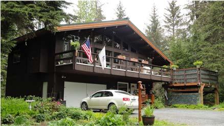
7 124 EGLOFF DR GARAGE GLACIER CITY HALL 139 KITZBUHEL RD AFRAME 164 BILLY'S ALLEY ROAD LOG 168 BILLY'S ALLEY ROAD BUNG 181 BANFF CIR CHALET 213 MAIN STREET MOD


8 214 BRIGHTON RD CHALET 225 MAIN STREET CABIN 228 BRIGHTON RD ALPINE 242 BRIGHTON RD CHALET 257 CORTINA RD CABIN 274 BRIGHTON RD ALPINE


9 282 HIGHTOWER RD TRAILER 286 MAIN STREET CABIN 287 MAIN STREET GAMBREL 295 MAIN STREET LOG 301 MT HOOD DR HANGAR 301 MT HOOD DR SHED


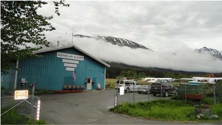
10 305 OLD DAWSON ROAD 2LVL 325 MT HOOD DR HANGAR 360 BORETIDE RD CABIN 500 BORETIDE RD CABIN 571 MT HOOD DR COM 599 MT HOOD DR COM ALPINE AIR ALASKA


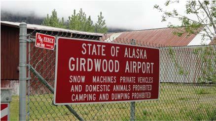
11 663 ALYESKA VIEW AVE ALPINE ALYESKA VIEW AVE CABIN REMAINS CABIN REMAINS CROW CREEK MINE SIGN GIRDWOOD AIRPORT GATE


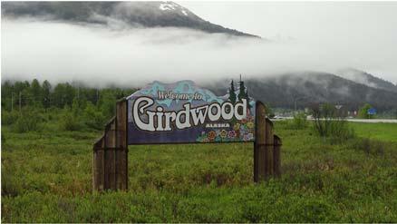
12 GIRDWOOD AIRPORT HANGARS GIRDWOOD AIRPORT RUNWAY GIRDWOOD AIRPORT SIGN GIRDWOOD SIGN INTERSECTION ALYESKA VIEW AVE ASPEN MOUNTAIN RD MT ALYESKA

13 ROUNDHOUSE ALYESKA TURNAGAIN ARM FROM ROUNDHOUSE
HEA WORKSHOP A few suggestions for things to do while you re in Alaska
 HEA WORKSHOP A few suggestions for things to do while you re in Alaska During the workshop: Remember it doesn t get dark, so after the workshop you could Start at the Log Cabin Downtown Visitor Information
LOCATION. A. Setting West Anchorage District Plan
 A. Setting West Anchorage District Plan LOCATION The West Anchorage Planning Area is within the Anchorage Bowl; roughly bounded by Westchester Lagoon to the north, Minnesota Drive to the east, and Cook
Courtesy of Wayde Carroll/Alaska Wildland Adventures. Alaska
 Courtesy of Wayde Carroll/Alaska Wildland Adventures Alaska A SPECIAL CONSERVANCY DEPARTURE AUGUST 28 - SEPTEMBER 4, 2016 Join us and fellow supporters on this excursion to Alaska. Spend time with us during
Bell s Travel Guides
 Bell s Travel Guides Seward Highway Road Log Mile by Mile Description of the Seward Highway so you always know what lies ahead. Anchorage, Alaska to Seward, Alaska This 127 mile/204 km highway has been
Segment 2: La Crescent to Miller s Corner
 goal of the USFWS refuges is to conserve, protect and enhance fish, wildlife and plants and their habitats for the continuing benefit of the American people. Refuge lands are used largely for fishing,
KALEO Tours / Oklahoma Christian Travelers
 KALEO Tours / Oklahoma Christian Travelers July 26- August 11, 2018 16 days of unequaled beauty!!! Once you ve been to Alaska you never come all the way back. Tour # 18-0726 Price: $3988.00 pp dbl. Includes:
A Publication of Friends of Sleeping Bear Dunes
 A Publication of Friends of Sleeping Bear Dunes 2014, Friends of Sleeping Bear Dunes, P.O. Box 545, Empire, MI 49630 www.friendsofsleepingbear.org info@friendsofsleepingbear.org Learn more about the Friends
Alaska 8 Days / 7 Nights
 NORTH AMERICA Alaska 8 Days / 7 Nights Denali National Park, Anchorage & Kenai Peninsula Alaska Family Vacation Highlights Bike Ride in Anchorage Bike along the Coastal Trail to spot moose and local wildlife.
Trail Phasing Plan. Note: Trails in the Clear Creek Canyon area (Segments will be finalized in the future to minimize wildlife impacts
 Note: Trails in the Clear Creek Canyon area (Segments 2 5 and a future JCOS connection) will be finalized in the future to minimize wildlife impacts Trail Phasing Plan P Parking 3 Easy Trail Intermediate
Alaska Cruisetours: 11-Day Denali Express
 Alaska CruiseTours Alaska Cruisetours: 11-Day Denali Express Alaska Cruisetours Choose from FOUR Cruisetours featuring escorted Motorcoach and Railroad Tours to see the heart of this great land: 11-Day
155 acres on Tyaughton Lake 900 feet of Pristine Waterfront Private & Secluded Property
 155 acres on Tyaughton Lake 900 feet of Pristine Waterfront Private & Secluded Property 946 Tyaughton Lake Road Gold Bridge BC V0K1P0 900 ft of waterfront with 155 acres of south facing easy access. This
SENSITIVE AREAS: PART FIVE - AREAS OF LOCAL CONCERN
 S: PART FIVE - AREAS OF LOCAL CONCERN Some areas within the Cook Inlet Subarea warrant special attention due to the presence of highly productive wildlife habitat, the ability to sustain a large part of
Arrive in Fairbanks Afternoon at leisure Accommodations are at the Fairbanks Springhill Suites by Mariott
 LAND & SEA This trip will introduce you to both interior and coastal Alaska. Highlights include the train journey to Denali National Park aboard the luxurious Alaska Railroad GoldStar dome train, a flightseeing
THE REGION LAKE SUPERIOR THE GITCHI-GAMI TRAIL & THE NORTH SHORE
 LAKE SUPERIOR THE GITCHI-GAMI TRAIL & THE NORTH SHORE 7 LAKE SUPERIOR: Water covers 70% of the earth s surface area, but only 3% of it is freshwater. Saltwater makes up 97% of the earth s water supply.
Winter Alaska: Northern Lights & Iditarod For Jewish Singles in their 40 s, 50 s & 60 s March 1-9, 2018 Led by Bill Cartiff
 Winter Alaska: Northern Lights & Iditarod For Jewish Singles in their 40 s, 50 s & 60 s March 1-9, 2018 Led by Bill Cartiff Thursday, March 1: ARRIVE ANCHORAGE Located in Southcentral Alaska on the shores
13.1 REGIONAL TOURISM ISSUES AND SUMMARY OF FINDINGS
 13 REGIONAL TOURISM T he County of Mariposa s recreation needs and facilities fall within two categories: regional tourism and local recreation. This Element focuses on regional tourism issues related
GOLDEN EARS PROVINCIAL PARK
 GOLDEN EARS PROVINCIAL PARK Trail Information as of October 10 th 2015 Do not underestimate the mountainous wilderness of Golden Ears Provincial Park. The combination of rugged terrain and rapidly changing
CHAPTER 5. Chapter 5 Recreation Element
 CHAPTER 5 Recreation Element Chapter 5 Recreation Element The Recreation Element of the Meyers Area Plan is a supplement to the Recreation Element of the TRPA Regional Plan and the El Dorado County General
CHAPTER 4 -- THE LAND USE PLAN: DESCRIPTIONS AND POLICIES FOR THIRTEEN PLANNING AREAS
 CHAPTER 4 -- THE LAND USE PLAN: DESCRIPTIONS AND POLICIES FOR THIRTEEN PLANNING AREAS NORTH CENTRAL CAC AREA LITTLE VALLEY ROAD TO JUG HANDLE CREEK PLANNING AREA This planning area includes Cleone, Noyo,
Alaska Trails/Confluence/Adventure Alaska Fund Building a Powerful Alaskan Outdoor Recreation Economy Why, What, and One Path to Get There
 Alaska Trails/Confluence/Adventure Alaska Fund Building a Powerful Alaskan Outdoor Recreation Economy Why, What, and One Path to Get There Steve Cleary, Alaska Trails Lee Hart Levitation 49/ Valdez Adventure
Alaska Kenai Peninsula
 Trip Summary Experience the best of Alaska in six days on our Alaska Adventure. Kayak Resurrection Bay in search of porpoises, sea lions and orca whales and listen for the sharp crack! of Holgate Glacier
THE SETTING REGION COMMUNITY ANALYSIS
 THE SETTING REGION COMMUNITY ANALYSIS REGION Historical Setting The Crane Lake waterway pre-dates the American Indians who traveled its waters for generations before it became a fur-trading route for the
playwinterpark.com Off The Beaten Path Hikes Hiking Recommendations for the Adventurous Hiker
 playwinterpark.com Off The Beaten Path Hikes Hiking Recommendations for the Adventurous Hiker Hike: Devil s Thumb (difficult) Length: 3.93 miles one-way Elevation: Trailhead 9609 Destination 12,236 Trailhead
GATEWAY PHASE 2. U.S. Forest Service and the Mount Shasta Trails Association
 GATEWAY PHASE 2 U.S. Forest Service and the Mount Shasta Trails Association PROJECT DEVELOPMENT Brief history - Gateway Phase 1 - IMBA conceptual plan - BikeShasta: concert series - USFS & MSTA partnered
SAR JOURNEY TO ALASKA
 SAR JOURNEY TO ALASKA POST TRIP TO DENALI NATIONAL PARK Sunday, May 22, 2016 - Arrive Seward, Alaska Holland America s Noordam will clear customs in Seward early morning. After a wonderful breakfast on
Wilds. Headwaters. Lakes. Oxbows. Falls
 56 5 4 3 Wilds Headwaters Lakes Oxbows Falls 57 Zones It could be said the on-the-ground essence of this master plan appears within the next 6 pages of this report. As we learned in the preceding Cultural
TRAILS. RM10_Cultural Resources Survey Report_ Stephen R. Braund & Associates
 TRAILS SRB&A s literature review identified five trails within or in close proximity to the direct APE (Map 15). These trails include the Wet Gulch/Willow Creek, Iditarod Trail Sled Dog Race Route, Iditarod
Restore and implement protected status that is equivalent, or better than what was lost during the mid-1990 s
 THE ROSSLAND RANGE, OLD GLORY AREA. Executive summary. The Friends of the Rossland Range Society, on behalf of the local outdoor community, seeks to accomplish the following with respect to the Old Glory
Chuckanut Ridge Fairhaven Highlands EIS Scoping Concerns
 Chuckanut Ridge Fairhaven Highlands EIS Scoping Concerns Coalition of Southside Neighborhoods CSN Comments for Fairhaven Highlands EIS Scope Hearing, Jan 16, 2008 1 Chuckanut Ridge Hilly Terrain: Potential
Taming the Last Frontier 8 days 7nights
 NORTH AMERICA Taming the Last Frontier 8 days 7nights Anchorage, Denali and Kenai Fjords National Parks Highlights Day 3 : Private Jet Boat Excursion Ride an exhilarating jet boat along the glacier-fed
BROCHURE. APPLE HILL WOODS 118 +/- Acres Camino, California. Presented by Jim Copeland
 BROCHURE APPLE HILL WOODS 118 +/- Acres Camino, California Presented by Jim Copeland 1 The Property This 118 acre is a rare gem in the Sierra Nevada foothills. Covered with lush forestland and scattered
THE ALBERTA GAZETTE, SEPTEMBER
 VILLAGE OF CEREAL Order No. 16915 IN THE MATTER OF THE "Municipal Government Act": File No. 241(A)3 AND IN THE MATTER OF an application by the Council of the Village of Cereal, in the Province of Alberta,
Hudson Highlands Fjord Trail Draft Master Plan. April 29, 2015
 Hudson Highlands Fjord Trail Draft Master Plan April 29, 2015 Agenda Route Overview Proposed Segment Results of Community Survey on that Segment Next Steps Municipal Endorsement Environmental Review Implementation
A number of goals were identified during the initial work on this Big Lake Transportation Plan.
 C. Transportation General Background Information Big Lake s transportation system includes all the roads, paths and facilities that allow the movement of private vehicles, trains and planes, as well as
S Central Coast Heritage Protection Act APRIL 21, 2016
 STATEMENT OF GLENN CASAMASSA ASSOCIATE DEPUTY CHIEF, NATIONAL FOREST SYSTEM U.S. FOREST SERVICE U.S. DEPARTMENT OF AGRICULTURE BEFORE THE UNITED STATES SENATE COMMITTEE ON ENERGY AND NATURAL RESOURCES
Non-motorized Trail Plan & Proposal. August 8, 2014
 Town of Star Valley Ranch, Wyoming and the Star Valley Ranch Association in partnership with the USDA Forest Service, Bridger-Teton National Forest, Greys River Ranger District Non-motorized Trail Plan
MOUNTAINS WILDLIFE & GLACIERS
 MOUNTAINS WILDLIFE & GLACIERS This triple-threat Alaskan getaway will have you soaring high above Denali National Park, paddling along frigid icebergs by kayak, and lumbering through the mountains in a
Unit 3: Klehini River All subunits 39 users/day (Allowed Use) Use: Rafting, Hiking
 Use: Rafting, Hiking") Haines State Forest Units & Subunits Activities Supplemental LAS 28996 Land Use Permit Application Alaska Mountain Guides & Climbing School Also DBA International Wilderness Leadership School Unit 3: Klehini
Haines State Forest Units & Subunits Activities Supplemental LAS 28996 Land Use Permit Application Alaska Mountain Guides & Climbing School Also DBA International Wilderness Leadership School Unit 3: Klehini
Proposal to Redevelop Lower Kananaskis River-Barrier Lake. Bow Valley Provincial Park
 Frequently Asked Questions Proposal to Redevelop Lower Kananaskis River-Barrier Lake Bow Valley Provincial Park Frequently Asked Questions What has been decided? What are the details of the plan? What
Dungeness Recreation Area County Park Master Plan
 Dungeness Recreation Area County Park Public Outreach Meeting October 10, 2007 Project Overview USFWS Site Dungeness Recreation Area County Park Meeting Objectives: Re-Introduce project; provide status
DAKOTA CULTURE UPPER SIOUX COMMUNITY: AREA CHARACTER ANALYSIS ALIGNMENT STRATEGY
 UPPER SIOUX COMMUNITY: AREA CHARACTER ANALYSIS ALIGNMENT STRATEGY 51 AREA CHARACTER ANALYSIS: OPPORTUNITIES & CONSTRAINTS RECREATIONAL VEHICLE PARK: A recreational vehicle park will be built to accommodate
April 10, Mark Stiles San Juan Public Lands Center Manager 15 Burnett Court Durango, CO Dear Mark,
 Mark Stiles San Juan Public Lands Center Manager 15 Burnett Court Durango, CO 81301 Dear Mark, We are pleased to offer the following comments on the draft San Juan Public Lands Center management plans
Included Tour Highlights: Small Group Alaska Tour Maximum group - 13 passengers Subject to Availability at time of reservation with paid deposits
 Explorer: ATG-26 From Monday, August 12, 2019 To Wednesday, August 21, 2019 Discover The Great Land - Alaska! Where you ll find bald eagles, bull moose, dramatic mountains and glaciers, wildflower covered
ALASKA. Iditarod Sled Dog Race. JAPAN Naoya Asao SOUTH KOREA Justin Jung
 STATE OF 610 E 5th Ave, Ste 200 Anchorage, Alaska 99501 travelalaska.com/trade Tanya Carlson Director of Marketing & Travel Trade Relations Tel: 907-646-3304 Email: tcarlson@alaskatia.org GERMAN SPEAKING
Gardner: overview. Santa Fe, Oregon, and California National Historic Trails UNINCORPORATED JOHNSON COUNTY OLATHE UNINCORPORATED JOHNSON COUNTY
 Santa Fe, Oregon, and California ational Historic Trails : overview 99: p.134 100: p.135 GARDER JUCTIO 102: p.137 56: p.126 EDGERTO Burlington orthern Intermodal and Logistics 98: p.133 101: p.136 S Waverly
Alaska 8 Days / 7 Nights
 NORTH AMERICA Alaska 8 Days / 7 Nights Anchorage, Denali and Kenai Fjords National Parks Alaska Family Vacation Highlights Bike ride through Anchorage Bike along the Coastal Trail to spot moose and local
Village of Taos Ski Valley 2015 Master Plan. Recreation Element
 Village of Taos Ski Valley 2015 Master Plan Taos Ski Valley is known across the world for skiing and winter sports, but the Village has more to offer than advanced skiing terrain and short lift lines.
Wallace Brothers Mountain Recreational Use Assessment
 Wallace Brothers Mountain Recreational Use Assessment Introduction Prepared for: Colony Home Investment Prepared by: SE Group November 28, 2011 Increasingly, communities are looking to recreation as an
CRANE LAKE TRAILS NETWORK AND SPACES
 CRANE LAKE TRAILS NETWORK AND SPACES AREA TRAILS COMMUNITY TRAILS GOLD COAST TRAIL LAKE PARK OPTION ONE LAKE PARK OPTION TWO OVERFLOW TRAILHEAD PARKING THE GATE AREA TRAILS Trails are a major resource
Kit Carson-Challenger Ridge Trail Project Annual Performance Report-2014 October 22, 2014
 1 Kit Carson-Challenger Ridge Trail Project Annual Performance Report-2014 October 22, 2014 Willow Lake and Kit Carson Peak 2 SUMMARY The Rocky Mountain Field Institute began Phase 1 of a multi-phase,
ALASKA. Iditarod Sled Dog Race. Japan Naoya Asao AVIAREPS Marketing Garden alaska-japan.com
 alaska travel industry association 2600 Cordova Street, Suite 201 Anchorage, Alaska 99503 Tel: 907-646-3308 Fax: 907-561-5727 travelalaska.com Jesse Carlstrom Travel Trade & International Marketing Manager
2.0 PARK VISION AND ROLES
 2.0 PARK VISION AND ROLES 2.1 Significance in the Protected Area System Marble Range and Edge Hills provincial parks protect 6.8% of the Pavillion Ranges Ecosection, which is located in the Southern Interior
Dnigi Hut. Dnigi is Dnaina for Moose. Location:
 Dnigi Hut in places. Stay on the main thoroughfare. Continue along the ridge top, going east to a pass above Knob Creek. Just beyond here look for a left turn which descends north-northwest (61,45.578,-148,52.414,2081
Clackamas County Development Agency
 Clackamas County Development Agency Development Services Building, 150 Beavercreek Rd., Oregon City, OR 97045 www.clackamas.us/transportation/renewal 503-742-4323 The Clackamas County Board of Commissioners
4.19 Parks, Recreation, and Conservation Lands
 interchange would have on the Reed Paige Clark Homestead located on the north side of Stonehenge Road. Alternative D would also affect Palmer Homestead, E.F. Adams House, and Knapp Brothers Shoe Manufacturing
TAYLOR CANYON RANCH COLORADO - ROUTT COUNTY - STEAMBOAT SPRINGS
 TAYLOR CANYON RANCH COLORADO - ROUTT COUNTY - STEAMBOAT SPRINGS Tucked up against the steep valley shaped by Mt. Pau and rising to the Routt National Forest, Taylor Canyon Ranch is an easily accessible,
Alaska. Wilderness and wildlife. Departs July 1, 2019
 a Alaska Wilderness and wildlife Departs July 1, 2019 Itinerary correct as at Jun 06, 2018, but subject to change. ALL flights to be confirmed. www.bluedottravel.com.au $14,799 pp Twin-share, economy class
MASTER PLAN EXECUTIVE SUMMARY
 Biscuit Run State Park Scottsville Road (State Route 20) Charlottesville, VA 22902 Biscuit Run State Park MASTER PLAN EXECUTIVE SUMMARY Department of Conservation and Recreation Division of Planning and
HEART OF ALASKA WILDERNESS LODGE RETREAT
 HEART OF ALASKA WILDERNESS LODGE RETREAT This is the ultimate Alaskan lodge experience, with visits to three unique lodges. With activities running the gamut from heli-hiking and sport fishing to wildlife
Clearwater Lake Provincial Park. Draft Management Plan
 Clearwater Lake Provincial Park Draft Management Plan Clearwater Lake Provincial Park Draft Management Plan Table of Contents 1. Introduction... 3 2. Park History... 4 3. Park Attributes... 4 3.1 Location/Access...4
Alaska Railroad - Seward to Anchorage
 Alaska Railroad - Seward to Anchorage 1 Content 1. The Alaska Railroad... 4 1.1 History of the Alaska Railroad...5 2. The Route in Train Simulator... 6 2.1 Overview...6 2.2 Landmarks...7 2.2.1 Seward...7
Proposal to Redevelop Lower Kananaskis River-Barrier Lake. Bow Valley Provincial Park. Frequently Asked Questions
 Proposal to Redevelop Lower Kananaskis River-Barrier Lake Bow Valley Provincial Park Frequently Asked Questions What is being proposed? What are the details of the proposal? Where is the project area located?
Silver Lake Park An Environmental Jewel for the Citizens of Prince William County
 Silver Lake Park An Environmental Jewel for the Citizens of Prince William County The Prince William Park Authority Mission Statement states: The Prince William County Park Authority will create quality
Arrive in Seward Private transfer to Talkeetna Visit the Alaska Wildlife Conservation Center Accommodations are at the Talkeetna Alaskan Lodge
 EXPLORE TALKEETNA This short journey introduces you to quintessential Alaskan experiences, and is perfect for outdoor enthusiasts. Soar over Denali on a flightseeing adventure, cruise along Talkeetna river
At the time, the portion of the line through Eagle County remains wholly under the ownership of Union Pacific Railroad (UP).
.") Chapter 5 The Railroad Corridor as a Trail Corridor The intent of this chapter is to identify how the rail corridor, if available for lease or purchase in all or part, could be incorporated into the core
Chapter 5 The Railroad Corridor as a Trail Corridor The intent of this chapter is to identify how the rail corridor, if available for lease or purchase in all or part, could be incorporated into the core
2. Goals and Policies. The following are the adopted Parks and Trails Goals for Stillwater Township:
 D. PARKS AND TRAILS 1. Introduction Stillwater Township s population is relatively low, with most residents living on rural residences on large lots. The need for active park space has been minimal in
Keansburg: Satellite Photo by USGS. Township of Middletown, and the western tip of Keansburg is adjacent to the Borough of
 Keansburg 1. Overview of Keansburg and Its Waterfront Keansburg: Satellite Photo by USGS 1.1 Geographical Overview The Borough of Keansburg is one of nine communities that comprise the Bayshore Region
1.2 Corridor History and Current Characteristics
 SECTION 1 Description and Background of Study Area 1.1 Introduction This preliminary engineering report was prepared for the Alaska Department of Transportation and Public Facilities (ADOT&PF). It is part
LEVEL 1 - AVALANCHE OVERVIEW HANDOUT
 Bill Glude Alaska Avalanche Specialists 20111202 All photos and graphics Bill Glude unless otherwise noted. LEVEL 1 - AVALANCHE OVERVIEW HANDOUT Summary of Key Points Statistics 1 2 3 Urban Avalanches
Other Agencies and Organizations
 Daniel Boone National Forest 1700 Bypass Road WInchester, KY 40391 859-745-3100 Location Northern terminus is near Morehead, Kentucky. Southern terminus is located in the Big South Fork NRRA in Tennessee.
HIKING IN THE CANADIAN ROCKIES
 HIKING IN THE CANADIAN ROCKIES Distance Time Elevation y MORAINE LAKE TRAILS THE ROCKPILE 0.8 km (0.5 mi) 20 min 30 m (98 ft) Located adjacent to the Lodge, the short interpretive trail up the Rock Pile
Alaska Ferry Vacations 10 Day Combo Inside Passage and Denali
 Alaska Ferry Vacations 10 Day Combo Inside Passage and Denali Reference: 4459 TRAVEL ARRANGEMENTS Travel Arrangements starting at US$3,575.00 per person for Double Occupancy Single, Triple and Quad Occupancy
Woodland Mountain Property
 Woodland Mountain Property So Close, Yet So Far Away Summit County, Utah 5 Acres $79,000 3616 Elmwood Street, Salt Lake City, UT 84106 801-870-1801 info@landrancher.com Welcome to Woodland Mountain Enjoy
TRUCKEE TAHOE AIRPORT DISTRICT BOARD OF DIRECTOR STAFF REPORT
 AGENDA ITEM: 11 TRUCKEE TAHOE AIRPORT DISTRICT BOARD OF DIRECTOR STAFF REPORT AGENDA TITLE: MEETING DATE: January 24, 2018 PREPARED BY: NTPUD Agency Partnership Opportunity, Multi-Use Trailhead Access
Alaska Family Kenai Peninsula
 Trip Summary Vast, pristine and blessed with an abundance of astounding scenery and wildlife, the wonders of Alaska amaze explorers of all ages. Hike to the edge of an active glacier. Explore tide pools,
5.0 OUTDOOR RECREATION OPPORTUNITIES AND MANAGEMENT
 5.0 OUTDOOR RECREATION OPPORTUNITIES AND MANAGEMENT 5.1 Introduction This section describes the range of recreational activities that currently take place in Marble Range and Edge Hills Parks, as well
LANGLADE COUNTY ICE AGE NATIONAL SCENIC TRAIL CONDITIONS (As of May 18, 2017)
") LANGLADE COUNTY ICE AGE NATIONAL SCENIC TRAIL CONDITIONS (As of May 18, 2017) Due to situations beyond the control of the Langlade County Chapter of the Ice Age Trail Alliance, conditions are constantly
LANGLADE COUNTY ICE AGE NATIONAL SCENIC TRAIL CONDITIONS (As of May 18, 2017) Due to situations beyond the control of the Langlade County Chapter of the Ice Age Trail Alliance, conditions are constantly
Paskapoo Slopes and Natural Area
 Paskapoo Slopes and Natural Area Along the western boundary of Calgary, rising above Sarcee Trail and the Trans-Canada Highway is an escarpment known as the Paskapoo Slopes. The area is a significant natural,
Arches of the. Sandflats Area. By Virginia Allen
 Arches of the Sandflats Area By Virginia Allen TABLE OF CONTENTS Introduction Dedication Road Log Arches 1. Perforated View Arch 2. Fee Booth Arch 3. Windsong Arch 4. Weird Arch 5. Resting Arch 6. Bike
NEWBORO AND PORTLAND HARBOUR REDVELOPMENT PLANS
 INTRODUCTION The Municipal docks in both Newboro and Portland were transferred to the Township of Rideau Lakes by Parks Canada in 2002. Little has been done to improve the docks physical condition or role
Wildlife Tour (10 Days)
") Multi-Sport Camping Adventures Small Groups (10 max) Great Guides Top of the line Equipment Excellent Meals Active Experiences Wildlife Tour (10 Days) For those with wildlife viewing as a primary objective
Multi-Sport Camping Adventures Small Groups (10 max) Great Guides Top of the line Equipment Excellent Meals Active Experiences Wildlife Tour (10 Days) For those with wildlife viewing as a primary objective
Lakes, Mountains and Brown Bears: Traveling with Beau
 Perspectives in Veterinary Medicine Lakes, Mountains and Brown Bears: Traveling with Beau Author s Note: This is the tenth in a series of stories 1 reflecting on a 2007 trip to Alaska with my dog, Beau.
Alaska Ferry Vacations
 Alaska Ferry Vacations Tour Name : 10 Day Combo, Inside Passage and Denali Expedition Tour Number : 2059 TRAVEL ARRANGEMENTS Itinerary runs from Saturday thru Monday, 10 Days, and is based on 2 people
Trails Technical Committee
 Trails Technical Committee Winter 2017 Draft Report Alignment Proposals for the Inyo National Forest and the Town of Mammoth Lakes Map ID #S18 February 08, 2017 Map ID #S18 Key Agreements As of February
EXPLORE ALASKA. What is Alaska like? Page 1
 EXPLORE ALASKA Page 1 What is Alaska like? Geography: Alaska is impressive for its sheer size. It accounts for one fifth of the United States' total land area with more than 580,000 square miles. From
17: Good Design - Tombs Site
 Rural Design Workbook: 17: Good Design - Tombs Site Site Introduction: The Tombs/Sullivan/Horton site is located within the Town of Campbell and is a combination of three properties totaling 356 acres:
MULTI SPORT ADVENTURE
 MULTI SPORT ADVENTURE This trip is designed for the active explorer. Discover Alaska through outdoor activities, ranging from serene to heart-pounding! Kayak between glaciers, fish for wild salmon, and
ALASKA LAND EXCURSIONS
 ALASKA LAND EXCURSIONS ANCHORAGE BEAR VIEWING LAKE CLARK You re a bear country bound adventurer. Coast through the mountains of Lake Clark National Park by plane. After a beach landing, venture out to
Mt. Elbert East Ridge
 Mt. Elbert East Ridge Difficulty: Class 1 Exposure: None Summit Elev.: 14,440 feet Trailhead Elev.: 10,400 feet Elevation Gain: 4,100 feet Roundtrip Length: 8.5 miles Trailhead: South Elbert (near Twin
Being supremely spoiled in an unspoiled land.
 Being supremely spoiled in an unspoiled land. Essential Alaska 2013 Celebrity Millennium 17* 10 1 11 6 11 7 11 4 10 5 10 8 10 9** 11 10 11 *Land tour executed by motorcoach only. **Tour includes intra-tour
NORTHWEST SECTION CONTENTS: CLEVELAND PARK FOLWELL PARK RYAN LAKE PARK VICTORY PRAIRIE DOG PARK VICTORY PARK
 NORTHWEST SECTION CONTENTS: CLEVELAND PARK FOLWELL PARK RYAN LAKE PARK VICTORY PRAIRIE DOG PARK VICTORY PARK LUCY LANEY COMMUNITY SCHOOL N 33RD AVE N 33RD AVE SINGLE-FAMILY RESIDENTIAL MULTI-USE DIAMOND
Included Tour Highlights:
 Explorer: ATG-10 From Tuesday, August 14, 2018 To Thursday, August 23, 2018 Discover The Great Land - Alaska! Where you ll find bald eagles, bull moose, dramatic mountains and glaciers, wildflower covered
Lake Myra County Park. Wake County, North Carolina Community Forum #2 June 12, 2008
 Lake Myra County Park Wake County, North Carolina Community Forum #2 June 12, 2008 Welcome and Introduction Meeting Agenda Welcome Introductions of Project Team Master Plan Process Community Forum #1 Updates
MORGAN CREEK GREENWAY Final Report APPENDICES
 APPENDICES MORGAN CREEK GREENWAY Appendix A Photos of Existing Conditions in Trail Corridor Photos of existing conditions Main trail corridor - February 2009 Photos of existing conditions south bank Morgan
Kit Carson-Challenger Ridge Trail Project
 Kit Carson-Challenger Ridge Trail Project Project Accomplishments Report-USFS December 15, 2015 Photo courtesy of Justin Peterson 815 South 25 th Street, Suite 101 Colorado Springs, CO 80904 Dedicated
Watchorn Provincial Park. Management Plan
 Watchorn Provincial Park Management Plan 2 Watchorn Provincial Park Table of Contents 1. Introduction... 3 2. Park History... 3 3. Park Attributes... 3 3.1 Natural... 4 3.2 Recreational... 4 3.3 Additional
Mt. Hood National Forest
 United States Department of Agriculture Forest Service Mt. Hood National Forest Zigzag Ranger District 70220 E. Highway 26 Zigzag, OR 97049 503-622-3191 Fax: 503-622-5622 File Code: 1950-1 Date: June 29,
EXECUTIVE SUMMARY PROGRAM DEVELOPMENT REPORT PURPOSE EXISTING SETTING EXPANDING PARKLAND
 EXECUTIVE SUMMARY PROGRAM DEVELOPMENT REPORT PURPOSE As the culmination of the first phase of the master planning process, this Program Development Report creates the framework to develop the Calero County
ICEFIELDS TRAIL - CONCEPT
 ICEFIELDS TRAIL - CONCEPT Overview: Municipality of Jasper to Columbia Icefield 1 of 21 2 of 21 3 of 21 226 km Start: Municipality of Jasper Legend KM Marker Roads Proposed trail route 16 Jasper Zone 4
Rogue Gorge (Mt. Stella) Roadless Area-- T30S R3E (primarily in portions of Sections 23, 26, 33, 34 & 35)
 Roadless Area-- T30S R3E (primarily in portions of Sections 23, 26, 33, 34 & 35)") Rogue Gorge (Mt. Stella) Roadless Area-- T30S R3E (primarily in portions of Sections 23, 26, 33, 34 & 35) Rogue River-Siskiyou National Forest--High Cascades Ranger District Upper, higher elevation trail
Rogue Gorge (Mt. Stella) Roadless Area-- T30S R3E (primarily in portions of Sections 23, 26, 33, 34 & 35) Rogue River-Siskiyou National Forest--High Cascades Ranger District Upper, higher elevation trail