DAKOTA CULTURE UPPER SIOUX COMMUNITY: AREA CHARACTER ANALYSIS ALIGNMENT STRATEGY
|
|
|
- Tracy Chambers
- 5 years ago
- Views:
Transcription

1 UPPER SIOUX COMMUNITY: AREA CHARACTER ANALYSIS ALIGNMENT STRATEGY 51
2 AREA CHARACTER ANALYSIS: OPPORTUNITIES & CONSTRAINTS RECREATIONAL VEHICLE PARK: A recreational vehicle park will be built to accommodate visitors to the Upper Sioux Community on this former agricultural field. A short walking distance to the Prairie s Edge Casino and the Casino Store, it is to be connected to them by a short walking path. OPPORTUNITIES: The recreational vehicle park is also in close proximity to The Scout Island Overlook, the Sioux Veterans Memorial, the Union Cemetery, and the proposed visitors center. CONSTRAINTS: Tribal officials would like access from this park to the state trail. Steep slopes to the east and a small site are constraints. STAGECAOCH TRAIL: The existing Stage Coach Trail, a vacated road, is currently being used by Upper Sioux Community Facilities Management as a means of getting down the bluff without using the public roads. OPPORTUNITIES: This area is located close to all recreational amenities in the community. CONSTRAINTS: In order to work as a trail the road would have to be redesigned with switchbacks to compensate for the steep grade. The proximity to private homes many limit the design. TRIBAL OFFICES: The tribal offices of the Upper Sioux Community are located in the river bottoms below the bluff. Its amenities include bathrooms, drinking water, visitor information, and a parking lot. OPPORTUNITIES: The tribal office site could be a site for interpreting contemporary Dakota culture and a trailhead. CONSTRAINTS: The native flowers and berries in the area need to be respected. Trail alignment should not disrupt hunting by tribal members. 52
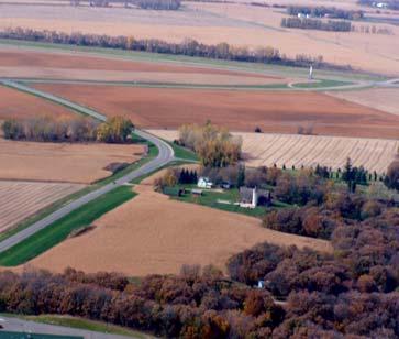
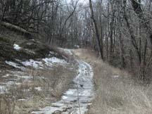
3 RECREATIONAL VEHICLE PARK STAGECOACH TRAIL TRIBAL OFFICES 53
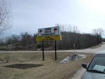
4 AREA CHARACTER ANALYSIS: OPPORTUNITIES & CONSTRAINTS PROPOSED INTERPRETIVE CENTER: The Upper Sioux Community plans to build an interpretative center next to its sign adjacent to the cemetery. This center would welcome visitors to the community and interpret the past and the present culture of the Dakota community. The site is very visible from the road and has striking views of the Minnesota River Valley. OPPORTUNIITES: This is a good place for a trailhead. The proposed center would have access to water, bathrooms, and parking, but more importantly, it could be a place for trail users to learn about the Dakota peoples. CONSTRAINTS: Although the center is planned, no construction date has been set. TRIBAL NEIGHBORHOOD: The tribe s newly constructed residential neighborhood on the top of the bluff has many amenities besides the housing. Visitor information, drinking water, bathrooms, and a parking lot are available at the Upper Sioux Community Center. OPPORTUNITIES: Routing the state trail through the neighborhood is undesirable; however, a local trail could connect to the state trail providing an opportunity for local residents to use the state trail. CONSTRAINTS: If the local trail connection were to be built, it needs to be designed to protect the neigh borhood and individuals who live there.community members and residents have concerns if the state trail were to go through the residential neighborhood. Concerns were expressed that opening the neighborhood to public use would compromise privacy and be disruptive. There is also a concern for the existing native flowers and berries. 54


5 PROPOSED INTERPRETIVE CENTER LOCATION 1 LOCATION 2 TRIBAL NEIGHBORHOOD 55
6 TRAIL ALIGNMENT & TRAILHEAD STRATEGY: The trail alignment and trailhead strategies for the Upper Sioux Community: Bring trail users into the Upper Sioux Community, Provide views of the Glacial River Warren Valley, Interpret the pre-european settlements and the contact history of the community, Protect existing native flora and fauna, Leverage existing and proposed community amenities, and Protect the privacy of community residents. TRAIL ALIGNMENT: POTENTIAL SPINE TRAIL: The potential spine trail: Leaves Highway 23 at Prairie s Edge Lane and passes the proposed Upper Sioux Community Center, the Upper Sioux Veteran s Memorial Plaza, the Union Cemetery, the Prairie View Recreational Vehicle Park, the Scout Island lookout and the Prairie s Edge Casino and Hotel, Turns east on Cavender Lane, Connects to the Wagon Trail Road via the utility right-of-way, Crosses Highway 67 and proceeds to 565 th Street passing the Upper Sioux Round House and administration buildings, Follows the bluff and to Waste Water Road to Highway 67, and Continues south to the Upper Sioux State Park. TRAILHEAD LOCATIONS: Two potential trailhead locations are identified within the Upper Sioux Comunity. 56


7 LEGEND MINNESOTA RIVER TRAIL POTENTIAL SPINE TRAIL POTENTIAL LOOP TRAIL POTENTIAL PRIVATE LAND EASEMENT TRAIL MN RIVER SCENIC BYWAY MAIN ROUTE ALTERNATE ROUTE STATE PARKTRAILS TRAILHEAD LOCATIONS EXISTING AMENTITY POTENTIAL AMENTITY OR INTERPRETATION COMMUNITIES CONSERVATION RESERVE LAND OR SCIENTIFIC & NATURAL AREA BOAT RAMP CARRY-IN CAMPING BACKCOUNTRY CAMPING REST AREA PARKING TRAILHEAD FACILITIES OVERLOOK DAM HISTORIC SITE FISHING ACCESS EQUESTRIAN CAMPING YELLOW ICONS = PROPOSED FACILITIES 57 57
Segment 2: La Crescent to Miller s Corner
 goal of the USFWS refuges is to conserve, protect and enhance fish, wildlife and plants and their habitats for the continuing benefit of the American people. Refuge lands are used largely for fishing,
Segment 4: Hokah to Mound Prairie
 Root River Wildlife Management Area The main unit of this WMA is located just north of the Root River and the city of Hokah. Its 443 acres include mixed hardwoods of oak, basswood, ash, cottonwood, elm
Business Item No
 Metropolitan Parks and Open Space Commission Meeting date: February 6, 2018 For the Community Development Committee meeting of February 20, 2018 For the Metropolitan Council meeting of February 28, 2018
Nov. 19 th Public Workshop Summary
 On November 19 th, more than 60 community members attended an Open Space Matters workshop at the Linen Building in downtown Boise for over two hours. Participants learned about reserves, discussed the
CHAPTER 5. Chapter 5 Recreation Element
 CHAPTER 5 Recreation Element Chapter 5 Recreation Element The Recreation Element of the Meyers Area Plan is a supplement to the Recreation Element of the TRPA Regional Plan and the El Dorado County General
CHAPTER 4 -- THE LAND USE PLAN: DESCRIPTIONS AND POLICIES FOR THIRTEEN PLANNING AREAS
 CHAPTER 4 -- THE LAND USE PLAN: DESCRIPTIONS AND POLICIES FOR THIRTEEN PLANNING AREAS SOUTH COAST CAC PLANNING AREA 4.10 NAVARRO RIVER TO MALLO PASS CREEK PLANNING AREA (Includes Greenwood/Elk) This planning
CRANE LAKE TRAILS NETWORK AND SPACES
 CRANE LAKE TRAILS NETWORK AND SPACES AREA TRAILS COMMUNITY TRAILS GOLD COAST TRAIL LAKE PARK OPTION ONE LAKE PARK OPTION TWO OVERFLOW TRAILHEAD PARKING THE GATE AREA TRAILS Trails are a major resource
Logo Department Name Agency Organization Organization Address Information 5700 North Sabino Canyon Road
 Logo Department Name Agency Organization Organization Address Information United States Forest Coronado National Forest 5700 North Sabino Canyon Road Department of Service Santa Catalina Ranger District
Mississippi River Parkway Commission of Minnesota
 Mississippi River Parkway Commission of Minnesota Metro Region (Elk River to Hastings) October 27, 2016 2:00 3:30 p.m. Historic Fort Snelling 200 Tower Avenue, St. Paul, MN Metro Region Agenda I. Welcome
Georgetown-Lewes Rail/Trail Study. Rail/Trail Study: Cool Spring to Cape Henlopen State Park New Road Extension (House Resolution No.
 Georgetown-Lewes Rail/Trail Study Rail/Trail Study: Cool Spring to Cape Henlopen State Park New Road Extension (House Resolution No. 47) August 22, 2011 Presentation Outline Background Benefits Statewide
Rogue River Access and Management Plan Draft Alternatives
 Rogue River Access and Management Plan Draft Alternatives The Rogue River Access and Management Plan was initiated in December, 2011 and is being led by Jackson County Parks (JCP) and Oregon Department
Little River Trail Feasibility Study
 Final April, 2014 Prepared for the State Coastal Conservancy By the Natural Resources Services Division of Redwood Community Action Agency Table of Contents Executive Summary... 1 1. Project Purpose and
SOUTH INTERCHANGE AREA
 Santaquin City General Plan 1 Location and Characteristics The South Interchange Area of Santaquin is located west of Interstate 15 and south of 500 South (Figure 1). It includes properties already annexed
Dakota County Planning Commission Advisory Committee Meeting Minutes Date: May 23, 2017 Time: 6:00 p.m. to 8:30 p.m.
 Dakota County Planning Commission Advisory Committee Meeting Minutes Date: May 23, 2017 Time: 6:00 p.m. to 8:30 p.m. Members Present Staff Present Mike Greco Trinity Augesen Vacant Lori Hansen Jill Smith
3. Trail Alignments and Connections
 3. Trail Alignments and Connections Overview of the Trail Alignment Study Area The CRVST is a legislatively authorized state trail which, when complete, will provide a connection between the Paul Bunyan
Mickelson Connector Feasibility Study
 Friends of the Norbeck PO Box 2003 Rapid City, SD 57709 www.friendsofthenorbeck.org Summary Comments on the Mickelson Connector Feasibility Study Prepared by Brian Brademeyer Submitted to Wyss Associates
Non-motorized Trail Plan & Proposal. August 8, 2014
 Town of Star Valley Ranch, Wyoming and the Star Valley Ranch Association in partnership with the USDA Forest Service, Bridger-Teton National Forest, Greys River Ranger District Non-motorized Trail Plan
Mississippi River Parkway Commission of Minnesota
 Mississippi River Parkway Commission of Minnesota Bluffs Region (Hastings to Iowa Border) September 23, 2016 10:00 11:30 a.m. Red Wing Ignite 419 Bush Street, Red Wing, MN Bluffs Region Agenda I. Welcome
AGENDA ITEM 5 D WAKULLA ENVIRONMENTAL INSTITUTE (WEI) TRAIL FEASIBILITY STUDY
 TRAIL FEASIBILITY STUDY") March 19, 2018 AGENDA ITEM 5 D WAKULLA ENVIRONMENTAL INSTITUTE (WEI) TRAIL FEASIBILITY STUDY TYPE OF ITEM: Action STATEMENT OF ISSUE The Wakulla Environmental Institute (WEI) Trail is one of several trails
March 19, 2018 AGENDA ITEM 5 D WAKULLA ENVIRONMENTAL INSTITUTE (WEI) TRAIL FEASIBILITY STUDY TYPE OF ITEM: Action STATEMENT OF ISSUE The Wakulla Environmental Institute (WEI) Trail is one of several trails
2. Goals and Policies. The following are the adopted Parks and Trails Goals for Stillwater Township:
 D. PARKS AND TRAILS 1. Introduction Stillwater Township s population is relatively low, with most residents living on rural residences on large lots. The need for active park space has been minimal in
Environment and Natural Resources Trust Fund 2019 Request for Proposals (RFP)
") Environment and Natural Resources Trust Fund 2019 Request for Proposals (RFP) Project Title: Glacial Edge Trail and Downtown Pedestrian Bridge Category: G. Land Acquisition for Habitat and Recreation ENRTF
Environment and Natural Resources Trust Fund 2019 Request for Proposals (RFP) Project Title: Glacial Edge Trail and Downtown Pedestrian Bridge Category: G. Land Acquisition for Habitat and Recreation ENRTF
Gardner: overview. Santa Fe, Oregon, and California National Historic Trails UNINCORPORATED JOHNSON COUNTY OLATHE UNINCORPORATED JOHNSON COUNTY
 Santa Fe, Oregon, and California ational Historic Trails : overview 99: p.134 100: p.135 GARDER JUCTIO 102: p.137 56: p.126 EDGERTO Burlington orthern Intermodal and Logistics 98: p.133 101: p.136 S Waverly
METROPOLITAN COUNCIL 390 North Robert Street, St. Paul, MN Phone (651) TDD (651)
 TDD (651)") METROPOLITAN COUNCIL 390 North Robert Street, St. Paul, MN 55101 Phone (651) 602 1000 TDD (651) 291 0904 DATE: June 19, 2007 TO: Metropolitan Parks and Open Space Commission FROM: Jan Youngquist, Senior
METROPOLITAN COUNCIL 390 North Robert Street, St. Paul, MN 55101 Phone (651) 602 1000 TDD (651) 291 0904 DATE: June 19, 2007 TO: Metropolitan Parks and Open Space Commission FROM: Jan Youngquist, Senior
Preferred Recreation Recommendations Stemilt-Squilchuck Recreation Plan March 2018
 Preferred Recreation Recommendations Stemilt-Squilchuck Recreation Plan March 2018 Below are the recommended recreation ideas and strategies that package together the various recreation concepts compiled
Pembina Valley Provincial Park. Draft Management Plan
 Pembina Valley Provincial Park Draft Management Plan 2 Pembina Valley Provincial Park Table of Contents 1. Introduction... 3 2. Park History... 3 3. Park Attributes... 3 3.1 Natural... 3 3.2 Recreational...
Lake Waconia Regional Park 6. Lake Waconia Regional Park
 Lower Lakeshore Trail Interpretive/Adventure Trail Multiple Seating & Observation Areas Flexible Day Use Recreation Area Docks/Fishing Group Camping Group Day Use Space Winter Gathering/Event Space -Season
17: Good Design - Tombs Site
 Rural Design Workbook: 17: Good Design - Tombs Site Site Introduction: The Tombs/Sullivan/Horton site is located within the Town of Campbell and is a combination of three properties totaling 356 acres:
OR MISSION TRAIL ELEMENTARY
 Leawood: overview OVERLAD PARK 24: p.70 I-LA PARK 32: p.72 TOMAHAWK PARK 23: p.69 31: p.71 GEZER PARK OR MISSIO TRAIL ELEMETARY 22: p.68 W 133rd St W 135th St KASAS CITY MO - other segments Beginning/end
5.0 OUTDOOR RECREATION OPPORTUNITIES AND MANAGEMENT
 5.0 OUTDOOR RECREATION OPPORTUNITIES AND MANAGEMENT 5.1 Introduction This section describes the range of recreational activities that currently take place in Marble Range and Edge Hills Parks, as well
Lake Myra County Park. Wake County, North Carolina Community Forum #2 June 12, 2008
 Lake Myra County Park Wake County, North Carolina Community Forum #2 June 12, 2008 Welcome and Introduction Meeting Agenda Welcome Introductions of Project Team Master Plan Process Community Forum #1 Updates
Trail Phasing Plan. Note: Trails in the Clear Creek Canyon area (Segments will be finalized in the future to minimize wildlife impacts
 Note: Trails in the Clear Creek Canyon area (Segments 2 5 and a future JCOS connection) will be finalized in the future to minimize wildlife impacts Trail Phasing Plan P Parking 3 Easy Trail Intermediate
BRACEVILLE NATURE PRESERVE Introductions History Present Conditions Future Development Plans Implementation Strategies Statistics
 BRACEVILLE NATURE PRESERVE Introductions History Present Conditions Future Development Plans Implementation Strategies Statistics Introduction Braceville Nature Preserve is one of MetroParks largest preserves.
Blue River Trail Master Plan JSA to Town Hall June 2004
 Blue River Trail Master Plan JSA to Town Hall June 2004 Prepared for: Silverthorne Town Council Silverthorne SPORT Committee Department of Recreation and Culture Silverthorne Public Works Silverthorne
Trails Technical Committee
 Trails Technical Committee Winter 2017 Draft Report Alignment Proposals for the Inyo National Forest and the Town of Mammoth Lakes Map ID #S18 February 08, 2017 Map ID #S18 Key Agreements As of February
When One Size Doesn t Fit All Building Volunteers with a Spectrum of Opportunity
 November 2013 PNTS When One Size Doesn t Fit All Building Volunteers with a Spectrum of Opportunity Claire Miller City of Scottsdale McDowell Sonoran Preserve The Preserve is Born 1991 Citizens form the
MASTER PLAN EXECUTIVE SUMMARY
 Biscuit Run State Park Scottsville Road (State Route 20) Charlottesville, VA 22902 Biscuit Run State Park MASTER PLAN EXECUTIVE SUMMARY Department of Conservation and Recreation Division of Planning and
Blueways: Rivers, lakes, or streams with public access for recreation that includes fishing, nature observation, and opportunities for boating.
 Parks, Open Space and Trails PRINCE WILLIAM COUNTY 2008 COMPREHENSIVE PLAN TRAILS PLAN CONTENTS The components of the trails plan are: Intent Definitions Goals, Policies, and Action Strategies Trails Map
CHAPTER III: TRAIL DESIGN STANDARDS, SPECIFICATIONS & PERMITS
 CHAPTER III Trail Design Standards, Specifications & Permits This chapter discusses trail standards, preferred surface types for different activities, permits, and other requirements one must consider
Committee Report. Community Development Committee For the Metropolitan Council meeting of April 13, Business Item No.
 Committee Report Business Item No. 2016-48 Community Development Committee For the Metropolitan Council meeting of April 13, 2016 Subject: Harriet Island-South St. Paul Regional Trail Master Plan, Saint
Paskapoo Slopes and Natural Area
 Paskapoo Slopes and Natural Area Along the western boundary of Calgary, rising above Sarcee Trail and the Trans-Canada Highway is an escarpment known as the Paskapoo Slopes. The area is a significant natural,
Camping (Primitive) Camping (RV) Electrical Potable Water Grill Established Fire Pit Picnic Table
 Camping (RV) Electrical Potable Water Grill Established Fire Pit Picnic Table") Alden - 9th Road River Mile 777 Map: 38.20833, -98.32031 Managing Agency: Kansas Department of Wildlife, Parks & Tourism Nearest Community: Alden, Rice County Kansas Developed Amenities Provided Parking
Alden - 9th Road River Mile 777 Map: 38.20833, -98.32031 Managing Agency: Kansas Department of Wildlife, Parks & Tourism Nearest Community: Alden, Rice County Kansas Developed Amenities Provided Parking
Public Comment. Comment To consider extending State Park lands above River Mile 7.0
 Public To consider extending Park lands above River Mile 7.0 on the Little Spokane River for the conservation and limited recreation qualities they contain is this request. Could this be included in your
Coast to Coast Connector Summit
 Project Partners Welcome to the Coast to Coast Connector Summit Winter Garden, Florida City Hall October 1, 2014 1 Why are we here? Objectives 1. Inform key stakeholders on the current state of the C2C
SUMMER VILLAGE OF SILVER SANDS. Municipal Development Plan
 SUMMER VILLAGE OF SILVER SANDS Municipal Development Plan Bylaw 253-2014 Adopted August 22, 2014 Summer Village of Silver Sands Municipal Development Plan Bylaw No. 253-2014 Page 2 1 INTRODUCTION 1.1 SETTING
THE REGION LAKE SUPERIOR THE GITCHI-GAMI TRAIL & THE NORTH SHORE
 LAKE SUPERIOR THE GITCHI-GAMI TRAIL & THE NORTH SHORE 7 LAKE SUPERIOR: Water covers 70% of the earth s surface area, but only 3% of it is freshwater. Saltwater makes up 97% of the earth s water supply.
EAST DON TRAIL ENVIRONMENTAL ASSESSMENT. Community Liaison Committee Meeting #3 July 15, :30 to 8:30 pm Flemingdon Park Library
 EAST DON TRAIL ENVIRONMENTAL ASSESSMENT Community Liaison Committee Meeting #3 July 15, 2013 6:30 to 8:30 pm Flemingdon Park Library Agenda 1. Welcome 2. Housekeeping and Updates a) Housekeeping b) CLC
SUBJECT: Mark Twain Birth Site Trail - Supplement 1, Mark Twain Lake Master Plan, Design Memorandum No. 9, Salt River, Missouri
 CEMVS-PM-E MEMORANDUM FOR FILE SUBJECT: Mark Twain Birth Site Trail - Supplement 1, Mark Twain Lake Master Plan, Design Memorandum No. 9, Salt River, Missouri 1. Reference: a. ER 1130-2-550, Chapter 3:
IOWA ORNITHOLOGISTS' UNION - Birding Sites in Dallas County
 IOWA ORNITHOLOGISTS' UNION - Birding Sites in Dallas County Printed on 7/19/2018 Beaver Bottoms Wetland (restricted) (Important Bird Area) GPS Coordinates:, Ownership: Private (see directions for access)
Stagecoach State Trail Master Plan
 Stagecoach State Trail Master Plan Minnesota Minnesota Department Department of of Natural Natural Resources Resources Parks and and Trails Trails Division Division Parks March March 2012 2012 The Minnesota
DATE: 23 March, 2011 TO: Communities FROM: BlazeSports America. RE: Accessible Trails Checklist 1
 M E M O R A N D U M DATE: 23 March, 2011 TO: Communities FROM: BlazeSports America RE: Accessible Trails Checklist 1 The purpose of the Accessible Trails Checklist (below) is to help the community review
Flying Cloud Airport (FCM) Zoning Process: Informing a Mn/DOT Path Forward
 Zoning Process: Informing a Mn/DOT Path Forward") : Informing a Mn/DOT Path Forward A Review of the Flying Cloud Airport (FCM) Joint Airport Zoning Board (JAZB) Process and the Draft Airport Zoning Ordinance B A RPZ RPZ A B C Zone Chad E. Leqve Director
: Informing a Mn/DOT Path Forward A Review of the Flying Cloud Airport (FCM) Joint Airport Zoning Board (JAZB) Process and the Draft Airport Zoning Ordinance B A RPZ RPZ A B C Zone Chad E. Leqve Director
Cuyuna Connection and Cuyuna Hills Backcountry Trail PROPOSED TRAIL DEVELOPMENT December 21, Trail Suitability Analysis
 Cuyuna Connection and Cuyuna Hills Backcountry Trail PROPOSED TRAIL DEVELOPMENT December 21, 2017 Trail Suitability Analysis Trail Suitability Criteria: As set forth in the Crow Wing County Comprehensive
FOR SALE : Land. XXXX St. Croix Trail S, Denmark Township, MN ACRES/4 PARCELS - RESIDENTIAL DEVELOPMENT FACTS & FEATURES
 FACTS & FEATURES List Price: $560,000 Property Type: Residential Land for Development Total Site - 10 Acres Currently Could Build 2 Homes on 5 Acres each Being Re-Platted for 4 lots ~2.5 Acres each Zoning:
Greater Minnesota Regional Parks and Trails Commission Designation Application
 Greater Minnesota Regional Parks and Trails Commission Designation Application General Section Designation Application #: 15-096D Date Submitted: 06/29/2015 Park or Trail Name: Barn Bluff Park District
PALO CORONA REGIONAL PARK MPRPD BOARD MEETING AUGUST 8, 2018
 PALO CORONA REGIONAL PARK MPRPD BOARD MEETING AUGUST 8, 2018 ACKNOWLEDGEMENTS AGENCIES AND ORGANIZATIONS The Trust for Public Land Big Sur Land Trust Santa Lucia Conservancy California State Parks Point
Southwest LRT Alignment Video Narration
 Southwest LRT Alignment Video Narration September 2015 Southwest Light Rail Transit, a proposed extension of the METRO Green Line, will serve Minneapolis, St. Louis Park, Hopkins, Minnetonka and Eden Prairie.
TRAFALGAR PARK. 78: p.140 W 99th St FLAT ROCK CREEK PARK. W 103rd St OVERLAND PARK. Quivira Rd. College Blvd. Shared use path. Mountain bike trail
 Lenexa: overview TRAFALGAR PARK 78: p.140 As the Westport Route crosses over Lenexa's boundaries with Olathe and Overland Park several times, approximately 2.75 or 3 miles of the historic route of the
3. Trail Alignment. Overview. Criteria for Location of the Trail
 3. Trail Alignment Overview The Houston to La Crescent Extension of the Root River Trail is part of the legislatively authorized Blufflands State Trail System. The entire trail segment is approximately
Definitions and Key Facility and Road Maintenance Costs
 Definitions and Key Facility and Road Maintenance Costs Cost Per Visitor: Total operational costs divided by total number of visitors. Cost Recovery: The percentage of expenses recovered through revenue.
Crystal Lake Area Trails
 Lake Area Trails Welcome to the Lake area of the Big Snowy Mountains! This island mountain range in central Montana features peaks reaching to 8,600 feet and long, high ridges from which vistas of the
The Chu property is a 6.57 acre parcel located in the Town of Superior on the west side of McCaslin Boulevard. In 2014, the Town of Superior acquired
 1 The Chu property is a 6.57 acre parcel located in the Town of Superior on the west side of McCaslin Boulevard. In 2014, the Town of Superior acquired the Chu property for open space with a contribution
Greater Minnesota Regional Parks and Trails Commission Designation Application
 Greater Minnesota Regional Parks and Trails Commission Designation Application General Section Designation Application #: 16-022D Date Submitted: 04/29/2016 Park or Trail Name: Luverne Loop & Blue Mounds
Submission on the Tukituki Catchment Proposal: EPA reference numbers; NSP 13/ , NSP 13/ , NSP 13/ , NSP 13/02.
 Hutt Valley Tramping Club PO Box 30 883 LOWER HUTT 5045 Tukituki Catchment Proposal Environmental Protection Agency Private Bag 63 002 WELLINGTON 6140 29 July 2013 Submission on the Tukituki Catchment
2009 RIVER TOWN OF THE YEAR AWARD APPLICATION Supplemental Material Images
 2009 RIVER TOWN OF THE YEAR AWARD APPLICATION Supplemental Material Images Our History The earliest record of settlement along the river is in 1854; one of the earliest in Carroll County. About this time
Conexus is committed to innovation and bringing financial services to market with speed. We have a long history of innovation, including:
 Corporate Profile Saskatchewan's largest and Canada's sixth largest credit union, Conexus has been serving its members for over 80 years. Today we manage more than $7.14 billion in funds and our 900 plus
EDEN PARK REDEVELOPMENT COMPLETED STADIUM DESIGN
 1 INTRODUCTION New Zealand was awarded the Rugby World Cup 2011 hosting rights in November 2005. A condition of the winning bid was the provision of a 60,000 seat stadium for the finals. New Zealand s
Chapter 6: POLICY AND PROCEDURE RECOMMENDATIONS
 Chapter 6 POLICY AND PROCEDURE RECOMMENDATIONS FOR SRRA Below are seven policy elements that should be considered for adoption by the Southwest Regional Recreation Authority of Virginia: 1. Develop strategies
PIONEER PARK. City of Des Peres Parks Master Plan. SWT Design 46 INTRODUCTION
 PIONEER PARK INTRODUCTION Pioneer Park is a 7 acre neighborhood park located east of Interstate 270 and south of Manchester Road along Tallie Road. The park is situated in a residential neighborhood with
Stephens Rd. Nature Preserve
 Stephens Rd. Nature Preserve History Stephens Road Nature Preserve (SRNP) is a 350-acre nature preserve in Huntersville that comprises nine properties purchased between 1994 and 2008. Parcels included
Meshach Browning Trail System at the Deep Creek Lake Lion s Club Park on Bumble Bee Rd.
 Meshach Browning Trail System at the Deep Creek Lake Lion s Club Park on Bumble Bee Rd. The Meshach Browning trail system will be a public, non-motorized, multi-use (running, dog-walking, cross country
Dungeness Recreation Area County Park Master Plan
 Dungeness Recreation Area County Park Public Outreach Meeting October 10, 2007 Project Overview USFWS Site Dungeness Recreation Area County Park Meeting Objectives: Re-Introduce project; provide status
South Fork/Greenway Center Trail, City of Middleton, WI
 South Fork/Greenway Center Trail, City of Middleton, WI Middleton, Wisconsin welcomes trail users of all abilities to continue their trek from the highly praised Pheasant Branch Conservancy Trail, through
EXECUTIVE SUMMARY FALL Introduction. Findings
 EXECUTIVE SUMMARY FALL 2004 Introduction Trails are one of the most popular and highly desirable recreational resources in communities of all sizes throughout the country. In addition to providing a safe
Driving Time: 3 hours (allow extra time for stops)
") Scenic Byways loop This journey takes visitors through the eastern edge of Mt. Rainier National Park and along two of Washington s most beloved scenic byways, the Chinook Byway and the White Pass Scenic
Scenic Byways loop This journey takes visitors through the eastern edge of Mt. Rainier National Park and along two of Washington s most beloved scenic byways, the Chinook Byway and the White Pass Scenic
CLEARWATER CREEK MASTER PLAN
 CLEARWATER CREEK MASTER PLAN CLEARWATER CREEK PRESERVE HUGO, MN 55038 December, 2018 Prepared for: City of Hugo 14669 Fitzgerald Ave North Hugo, MN 55038 WSB PROJECT NO. 11947 Table of Contents Executive
FEASIBILITY CRITERIA
 This chapter describes the methodology and criteria used to evaluate the feasibility of developing trails throughout the study areas. Land availability, habitat sensitivity, roadway crossings and on-street
Shooting Star State Trail Master Plan
 Shooting Star State Trail Master Plan Prairie Shooting Star Minnesota Department of Natural Resources Division of Trails and Waterways Historical photos courtesy of the Minnesota Historical Society. Photos
MORGAN CREEK GREENWAY CONCEPTUAL MASTER PLAN Including Carrboro High School Spur Trail TOWN OF CARRBORO
 CONCEPTUAL MASTER PLAN Including Carrboro High School Spur Trail TOWN OF CARRBORO FINAL REPORT FEASIBILITY ANALYSIS Prepared By COULTER JEWELL THAMES PA 15 March 2010 Coulter Jewell Thames, PA 111 WEST
LAS VARAS RANCH CA COASTAL TRAIL PROPOSED ALIGNMENT
 LAS VARAS RANCH CA COASTAL TRAIL PROPOSED ALIGNMENT Santa Barbara Trails Council * Prepared by Ray Ford February 1,2012 The following notes accompany the Santa Barbara Trails Council map for the Las Varas
National Recreation Trail Application for Designation
 National Recreation Trail Application for Designation Introduction Thank you for your interest in the National Recreation Trail (NRT) program. Completed NRT application packages must be submitted by December
WASHINGTON STATE PARKS LAND CLASSIFICATION SYSTEM
 WASHINGTON STATE PARKS LAND CLASSIFICATION SYSTEM Administrative Code Establishing Land Classification System WAC 352-16-020 Land classification system. State park areas are of statewide natural, cultural,
Brinker Creek Ranch. Colorado - Routt County - Yampa
 Located at the base of the Flattops Range in the Steamboat/Vail corridor, Brinker Creek Ranch consists of 1,451 acres ideally suited for high country grazing and native grass hay production. Traditionally
CHAPTER 1. INTRODUCTION. Vision Statement
 CHAPTER 1. INTRODUCTION Vision Statement The designated Iowa portion of the Mississippi River Trail (MRT) will consist of a world-class, continuous multi-use, non-motorized, on-road and off-road route
City of Solvang SUNNY FIELDS SPUR TRAIL STUDY
 City of Solvang SUNNY FIELDS SPUR TRAIL STUDY project description The City of Solvang, in partnership with the County of Santa Barbara Public Works Department, is developing an alignment study for a proposed
The Falls: A Visitor & Interpretive Center for the Upper Lock
 The Falls: A Visitor & Interpretive Center for the Upper Lock Image courtesy of Northern Spark Surface by Aaron Dysart Illuminate the Lock is a program of Mississippi Park Connection The Falls Initiative
Appalachian Mountain Club
 Appalachian Mountain Club January 30, 2013 Groton Planning Board 754 North Groton Road Groton, NH 03241 Re: Re-opened public hearing regarding a request by EDP Renewables (Lessee), EXPX2/MAXAM (Owner)
Project Summary 2009
 Project Summary 2009 SB-2009-MN-55360: Lady Slipper Scenic Byway Pedestrian Walkway State Submission Date not submitted Division Submission Date not submitted State Priority 0 This application must be
THOMAS A. SWIFT METROPARK Introductions History Present Conditions Future Development Plans Implementation Strategies Statistics
 THOMAS A. SWIFT METROPARK Introductions History Present Conditions Future Development Plans Implementation Strategies Statistics Introduction As an open meadow park positioned along the Mahoning River,
Header i
 Header i 048285014.10 Header Sub Title Body Text here. Body text here. Body text here. Section 1... 1 Executive Summary... 1 Opportunities and Constraints... 3 Overall Opportunities and Constraints Map
BLANKET CREEK PROVINCIAL PARK
 BLANKET CREEK PROVINCIAL PARK PURPOSE STATEMENT AND ZONING PLAN February 2003 BLANKET CREEK PROVINCIAL PARK Purpose Statement and Zoning Plan Primary Role The primary role of Blanket Creek Park is to maintain
Understanding the caring capacity of the visitor experience Provide facilities to support a high level user experience Address visual quality through
 Understanding the caring capacity of the visitor experience Provide facilities to support a high level user experience Address visual quality through recreation ecological restoration opportunities Collaboration
ILLINOIS RIVER CENTER AT HAVANA. Linking Resources for Success. Governor s Conference on the Management of the Illinois River System (October, 2005)
") ILLINOIS RIVER CENTER AT HAVANA Linking Resources for Success Governor s Conference on the Management of the Illinois River System (October, 2005) Linking Resources For Success COMMUNITY REVITALIZATION
ILLINOIS RIVER CENTER AT HAVANA Linking Resources for Success Governor s Conference on the Management of the Illinois River System (October, 2005) Linking Resources For Success COMMUNITY REVITALIZATION
THE SETTING REGION COMMUNITY ANALYSIS
 THE SETTING REGION COMMUNITY ANALYSIS REGION Historical Setting The Crane Lake waterway pre-dates the American Indians who traveled its waters for generations before it became a fur-trading route for the
4988 +/- ACRES JEFFERSON AND LEON COUNTY, FLORIDA
 4988 +/- ACRES JEFFERSON AND LEON COUNTY, FLORIDA Located in the famed Red Hills of north Florida, El Destino Plantation consists of 4988+/- acres and represents an incredible opportunity to own one of
RUSHMORE CONNECTOR TRAIL PROPOSAL
 PURPOSE AND NEED Background The U.S. Forest Service, Black Hills National Forest (Forest Service) has received a special use permit application from the State of South Dakota Department of Game, Fish and
Silver Lake Park An Environmental Jewel for the Citizens of Prince William County
 Silver Lake Park An Environmental Jewel for the Citizens of Prince William County The Prince William Park Authority Mission Statement states: The Prince William County Park Authority will create quality
Environment and Natural Resources Trust Fund (ENRTF) M.L Work Plan
 M.L Work Plan") Environment and Natural Resources Trust Fund (ENRTF) M.L. 2014 Work Plan Date of Report: 28 May, 2014 Date of Next Status Update Report: 15 January, 2015 Date of Work Plan Approval: Project Completion
Environment and Natural Resources Trust Fund (ENRTF) M.L. 2014 Work Plan Date of Report: 28 May, 2014 Date of Next Status Update Report: 15 January, 2015 Date of Work Plan Approval: Project Completion
National Recreation Trail Update Form
 National Recreation Trail Update Form Introduction Thank you for taking the time to complete this form. Your assistance will help ensure that the National Recreation Trail (NRT) database is complete and
A VISION FOR EL MIRAGE
 el mirage A VISION FOR EL MIRAGE OASIS, ARIZONA A thriving desert jewel destination with a strong arts district, high-wage employment parks system joined together by cohesive, multi-use accessible trails
COMMENT PERIOD INTRODUCTION
 To: Interested Persons From: Tom Buford File: Del Rio Trail Project Date: June 8, 2018 Community Development Department Reference: NOTICE OF PREPARATION OF AN ENVIRONMENTAL IMPACT REPORT FOR THE DEL RIO