Blue Ridge Recreation Area
|
|
|
- Randolph Thomas
- 6 years ago
- Views:
Transcription

1 Concept Plan for Blue Ridge Recreation Area Clear Creek, CO April, 2017
2


3 Prepa red fo r: Prepared by: Published: April, 2017


4 Concept Plan Executive Summary The proposed Blue Ridge Recreation Area (Blue Ridge) is located in and owned by Clear Creek (), Colorado. The beautiful Blue Ridge area is located just south of Interstate 70 and the Town of Dumont, about 30 miles west of Denver. The has an opportunity to develop and manage a unique multiple-use shared Recreation Area to benefit local residents & businesses and strengthen and diversify the local economy. The Recreation Area would also draw visitors interested in a new experience. A shared motorized and nonmotorized Recreation Area would create a very unique setting for people that would like diverse opportunities in one area close to where they live. High quality trails and facilities will make the Recreation Area a valuable place for people to have exceptional experiences in a beautiful Rocky Mountain setting. The primary experience in the area will be adventurous trail-based with challenges and spectacular views. A convenient trailhead and day use area will provide a well-designed and natural setting for visitors to have quality facilities, services, areas to gather and meet, programs and information to enjoy the area. This bold new idea for a public Recreation Area will require creativity, investment, cooperation, and commitment to be a success. If you d like to be involved in this great project, you re welcome join us for the ride Executive Summary
5 B lue Ridge Recreation Area Map - Concept Plan for Trails and Facilities Lawson Hole Whitewater Park Downieville Exit 233 Potential Trailhead Potential Trailhead Exit 234 Lawson Hole Whitewater Park Family OHV Skills & Practice Area Exit 233 Lawson Adventure Park & Lodging 70 Animal Adventure Shelter Park & Lodging Potential Trailhead Intermediate Trails C Mile Hi Rafting & ATV Tours 3Observation Creek Clear Lawson Weigh Station C Mile Hi Rafting & LDS ATV Tours er C it Road & Bridge Sportsmans Clu Silv Camp c 0.25 Miles er C ity School of Mines Rd School of Mines d yr Gathering Area/ C 3 Mountain Village 70 C Blue Ridge Rd Intermediate Trails Potential Trailhead Exit 235 CPotential Trailhead Gathering Area/ Rocky 3 Silv Dumont Family OHV Skills & Practice Area Shelter/ Gathering Interpretation 3 I V U 712 Shelter/ Gathering In I Interpretation 3 I V U 712 Interpretation I State Trust Land State Trust Land il Tra ek Cre Ove Rd 4x4-22 Miles USFS Roads Dirt/Gravel Roads 50 Inch Trail - Up to ATVs Miles Blue Ridge - Recrea 80 Inch Trail - All Vehicles - 9 Miles 18 Inch Trail - Dirt Bikes & All Bicycles Miles Recreation & Public 65 Inch Trail - Up to ROVs - 6 Miles Existing Trails Clear Creek 50 Inch Trail - Up to ATVs Miles I Blue Ridge - Recreation & Public Purpose (CCC) 80 Inch Trail - All Vehicles - 9 Miles 18 Inch Trail - Dirt Bikes & All Bicycles Miles Recreation & Public Purpose (CCC) State Land Board 65 Inch Trail - Up to ROVs - 6 Miles Existing Trails Clear Creek US Service Potential Trails - Open to All Uses I Local Major Arterial Collector 0 s Potential Trails - Open to All Uses Highway Colorado School of Mines 0.5 Miles Colorado School of M Private -Preliminary- Blue Ridge Park Concept Clear Creek C Executive Summary

6 Concept Plan Blue Ridge Property & Landscape
7 Blue Ridge Recreation Area CONTENTS Executive Summary D Introduction 1 Purpose 1 Benefits 2 Background Information 3 Economics & Trends 8 Participants & Outreach 9 Summary of Public Input 10 Concept Plan Elements 12 Recreational Experiences 12 Service Area for the Recreation Area 13 Recreation Programs 14 Resource Conditions 17 Trails and Facilities 18 General Recommendations 28 Implementation 30 Contributors 33 References 33
8 Concept Plan Blue Ridge Map - Blue Ridge Recreation Area is located in Clear Creek near the Town of Dumont and is 30 miles west of Denver, Colorado. Page H

 lands transferred to Clear Creek through a recent act of the US Congress.")
9 Blue Ridge Recreation Area Introduction The Blue Ridge area encompasses 562 acres of land owned by Clear Creek () located near the Town of Dumont, between the cities of Idaho Springs and Georgetown, Colorado. The site is located approximately 30 miles west of Denver. Blue Ridge is located in the central Rocky Mountains rising to the south from Interstate 70 and Clear Creek up to the edge of the Arapaho. The property was former Bureau of Land Management (BLM) lands transferred to Clear Creek through a recent act of the US Congress. Blue Ridge currently has unmanaged recreation use including motorized recreation, mountain biking, recreational shooting, camping, and hiking, among others. The purpose of this project was to create a general concept plan to explore how outdoor recreation opportunities and management of the Blue Ridge property could be developed and provided. Additional inventory, analysis, outreach, planning and design are recommended to further refine solutions. Purpose The purpose of the proposed Blue Ridge Recreation Area is to provide exceptional outdoor recreation experiences in a well-managed public land setting. Blue Ridge is intended to benefit both residents and visitors while strengthening the local economy. The desired visitor experience for the Recreation Area is to have adventure-based trail experiences in a beautiful and natural mountain setting. The intends to manage the Recreation Area as a multiple-use area for visitors interested in sharing facilities, trails, and programs. In this case, multiple-use means both motorized and non-motorized recreational uses. While multiple-use recreation commonly occurs on US Service (USFS) and Bureau of Land Management (BLM) lands, this approach to recreation benefiting many unique visitors on land is a unique and emerging opportunity. The is interested in providing well-designed facilities and programs to foster a diversity of recreation experiences with a focus on quality, safety and sustainability. Gathering areas and programs in the Recreation Area should create an attractive and comfortable setting for families, groups, and individuals to share experiences and get to know each other. The is committed to working with adjacent land owners to respect their property and manage both public use and the natural environment of the Blue Ridge area. The Recreation Area has the potential to serve as a trailhead and access to the Arapaho and nearby Colorado State Trust Lands. The USFS, Colorado State Land Board (SLB) along with the Stay the Trail organization have each communicated their interest in supporting this unique and innovative project. Page 1
, mountain biking o Hiking o Camping o Safety training o Hunting o Shared facilities and programs o Access to Clear Creek Better managed natural landscapes")

10 Concept Plan Benefits A few key benefits of a Blue Ridge Recreation Area would include: Improved outdoor recreation opportunities including but not limited to: o Motorized off-highway vehicle (OHV) recreation o E-biking (see definition below), mountain biking o Hiking o Camping o Safety training o Hunting o Shared facilities and programs o Access to Clear Creek Better managed natural landscapes Stronger and more diverse local economy Create jobs for management, programs, maintenance and enforcement Positive social setting for families, groups, and individuals Facilities, settings, and programs for schools, social and recreation groups Improved access to public lands Educational and interpretive information for visitors Improved safety and security Potential to serve as a role model for multiple-use recreation in Colorado Training and education for safe and ethical recreation on public lands Page 2


11 Blue Ridge Recreation Area Background Information Blue Ridge is 562 acres of -owned land located in Clear Creek (), just 30 miles west of Denver, Colorado. These former BLM properties were transferred to the and must be managed and used as recreation and public purpose lands. This designation means the must manage the property in perpetuity as land that will benefit the public and will provide recreational opportunities. The has held several public meetings about the purpose of the Blue Ridge property. To date, these meetings have focused on using the property to provide public recreation in a well-managed setting. As in much of the, mining has been a historical and common activity on Blue Ridge. The complex patchwork of land ownership in the area is due the many historic mining claims. These parcels were delineated for mining purposes and are often narrow strips of land. The Blue Ridge property has historically been an area of multiple uses similar to other BLM and USFS lands in the. These uses have included motorized recreation, mountain biking, recreational shooting, hunting, camping, and hiking, among others. Most of the roads in the area were originally created to provide access to the mines. Most of the roads on the Blue Ridge property are public rights-of-way, but there are a few private access roads as well. Blue Ridge has various adjoining lands that include: Private mining claims Private residential properties open space Animal Shelter Former mining claims now owned by the Colorado School of Mines State Trust lands managed by the Colorado State Land Board Arapaho lands managed by the USFS Blue Ridge has slopes ranging from moderate to steep, including many rock outcrops and steep draws. Most slopes are north-facing providing a cool and damp environment for growth of heavy timber and flowing streams. Many springs have flowing water, sometimes year-round which can cause ice build-up at some locations on roads. Most roads and trails are snow and ice covered during the winter months. There are a few ridge-tops and east-facing slopes with drier conditions leading to pine savanna vegetation. Colorado Parks and Wildlife (CPW) data shows the area is not located within known sensitive wildlife habitat areas. Colorado Natural Heritage Program (CNHP) data also shows Blue Ridge is not located within CNHP Potential Conservation Areas. The area does provide general mountain habitat for wildlife species such as deer, elk, bear, mountain lion, rabbits, wild turkey, among others. Page 3
12
13 Downieville 70 Lawson Hole Whitewater Park Lawson Adventure Park & Lodging Exit 233 Mile Hi Rafting & ATV Tours Exit 234 Weigh Station Animal Shelter Blue Ridge Rd Clear Creek LDS Dumont Exit 235 Road & Bridge 70 Sportsmans Club c Rocky Mountain Village Camp 0.25 Miles Silver City Rd School of Mines UV 712 State Trust Land Trail Creek Rd Highway Major Arterial Collector Local 4x4 Dirt/Gravel Roads Other Routes Existing Trails Blue Ridge - Recreation & Public Purpose (CCC) Source: Esri, DigitalGlobe, GeoEye, Earthstar Geographics, CNES/Airbus DS, USDA, USGS, AeroGRID, IGN, and the GIS User Community Blue Ridge Park Concept Plan Clear Creek Miles I Draft: 1/3/17
14 Downieville 70 Lawson Hole Whitewater Park Exit 233 Mile Hi Rafting & ATV Tours Blue Ridge Rd Exit 234 Weigh Station Animal Shelter Clear Creek Church Dumont Exit 235 Road & Bridge 70 Sportsmans Club Silver City Rd School of Mines UV 712 State Land Board Trail Creek Rd Blue Ridge Parcels HIGHWAY MAJOR ARTERIAL COLLECTOR LOCAL 4WD SERVICE Existing Trails Proposed Trails Elevation High : 11,497 Feet Low : 7,832 Feet Blue Ridge Park Concept Plan Clear Creek Miles I Draft: 11/17/16
15 Downieville 70 Lawson Hole Whitewater Park Exit 233 Mile Hi Rafting & ATV Tours Blue Ridge Rd Exit 234 Weigh Station Animal Shelter Clear Creek Church Dumont Exit 235 Road & Bridge 70 Sportsmans Club Silver City Rd School of Mines UV 712 State Land Board Trail Creek Rd Blue Ridge Parcels HIGHWAY MAJOR ARTERIAL COLLECTOR LOCAL 4WD SERVICE Existing Trails Proposed Trails Percent Slope Blue Ridge Park Concept Plan Clear Creek Miles I Draft: 11/17/16


16 Concept Plan Economics & Trends The Henderson Mine has been a very important contributor to the Clear Creek economy for over 40 years. The Mine has plans to close which will likely have a significant negative impact on the s economy. For this reason, and to diversify the local economy, the has decided to explore and expand opportunities for outdoor recreation and tourism. While the has a vast amount of public land within its boundaries, it lacks public and private recreation and tourism facilities such as trailheads, trails, campgrounds, resorts, equipment rental vendors, among others. Motorized recreation, or off-highway vehicle (OHV) riding, has been a popular activity in the since the invention of the combustion engine. Many residents and visitors enjoy exploring the historic mining roads in the beautiful mountain setting. OHV riding is a very popular outdoor recreation activity in Colorado, with approximately 22.5% of all Coloradoans participating (source: CO SCORP). OHV recreation is popular because it provides an adventurous experience while immersing participants in nature. It also allows people with a wide-range of physical conditions to explore the mountains and reach the backcountry. Colorado Parks and Wildlife reported that over 170,000 off-highway vehicle (OHV) registrations and use permits were issued in Colorado during the season. Between 2000 and 2014, OHV registrations for residents increased by 219 percent while OHV permits for non-residents increased by over 1,607 percent. During the season, motorized recreational enthusiasts spent an estimated $1.6 billion while taking trips using motorized vehicles for recreational purposes. Motorized recreational enthusiasts spent more than an estimated $724 million annually on various items to support and enhance their experiences in Colorado, including $163 million in new vehicle purchases. In total, motorized recreational enthusiasts were responsible for $2.3 billion in direct expenditures related to motorized recreation in Colorado during the season. Source: Economic Contribution of Off-Highway Vehicle Recreation in Colorado, Colorado Off-Highway Vehicle Coalition & Trails Preservation Alliance. Traditional forms of OHV recreation have included driving 4x4s and off-road motorcycles. Today, OHV recreation has diversified to include smaller vehicle such as all-terrain vehicles (ATV, a.k.a. 4-wheelers) and recreational off-highway vehicles (ROV, a.k.a. side by side or UTV). ROV s are the fastest growing segment of the OHV market. These vehicles provide a multiple-rider social experience with more cargo capacity. A key aspect of ROV s is they allow for a passenger experience, which is diversifying who can participate in this form of adventure. There is an opportunity to collaborate with OHV groups such as Stay the Trail, OHV clubs and the OHV industry to provide training and special events. There is a need for more designed sites for safety and ethics training for youth and beginners, especially in the greater Denver area. There are many popular forms of mountain-based outdoor recreation in Colorado. Mountain biking is among the most popular activities with approximately 22.1% of Coloradoans partaking (source: CO SCORP). Electric assist, or e-bikes, are a new form of bicycles available to Page 8


17 B lue Ridge Recreation Area riders. These e-bikes are electric-assist bicycles providing power to the rider while climbing hills or moderate grades. As with OHVs, e-bikes allow riders with varying physical capabilities to explore the mountains and reach the backcountry. In most places, e-bikes are limited to the use of roads and OHV trails in Colorado. There s a very unique and special opportunity to provide access to both standard and electric mountain bikes on the Blue Ridge property. There is also an opportunity to partner with the e-bike industry to use the area as a location for trial rides and special events. Participants & Outreach This report was prepared for Clear Creek by Great Outdoors Consultants (GOC). GOC has been advising the on the Blue Ridge Recreation Area for several years. GOC has experience working throughout the United States and internationally for clients such as the USFS, BLM, Park Service, Bureau of Reclamation, state parks, department of natural resources, game and fish, divisions of wildlife, counties, along with numerous local and private organizations. GOC are specialists in planning and design for all types of outdoor nature-based recreation including parks and protected area management, private land management, recreation trails and facilities design, off-highway vehicle recreation (OHV) travel management planning, nature-based tourism, summer camps and outdoor education. The has had extensive outreach in regards to the Blue Ridge property since the transfer of the land from BLM. The Board of Commissioners and OHV Committee have had multiple meetings discussing potential recreational uses of the Blue Ridge property. A public meeting was held during the preparation of this document to seek public input on a proposed concept plan. The meeting was held on January 17, 2017 in Idaho Springs, Colorado. Land owners within 3/4 miles of Blue Ridge were invited to the meeting by notifications sent via mail. Additionally, the following organizations were invited to participate in the meeting and contribute to the project. Page 9
18 Concept Plan Organizations and Individuals Invited to Contribute Local & Residents Board & Staff Clear Creek Metropolitan Recreation District Clear Creek Open Space Commission OHV Committee Animal Shelter Colorado School of Mines Mile Hi Rafting and ATV Tours Lawson Adventure Park & Lodging US Service Colorado Parks & Wildlife Colorado State Land Board Colorado Off-Highway Vehicle Coalition Trail Preservation Alliance Colorado Office of Outdoor Recreation Industry Stay the Trail Colorado Mile-Hi Jeep Club Colorado Motorcycle Trail Riders Association Summary of Public Input The following comments have been provided by public meeting participants and others who have ed comments to the. The stars to the right indicate the number of times the comment was made. There will be more opportunities to comment on the project as the continues to refine solutions. It will be important to continue to hold public meetings to engage recreational users, local residents and businesses in the process to find solutions to issues. This is particularly important for owners of private lands located close to the proposed recreation area. Page 10
19 Blue Ridge Recreation Area Comments Quantity Development of area would pay dividends to local community *************************** Desire for motorized club to adopt a trail in the area or assist with development ******************* In-favor of recreating at the Blue Ridge area ***************** Already use the area to recreate **************** Desire for day-trip riding options on the Front Range ************** Desire for family activities at the recreation area like ATV training and novice routes ************ In-favor of proper management with off-highway-vehicle use ********** Economic analysis wanted ********* Generally, not in favor ******** Concern for fire mitigation ******* Concern on noise impacts to residential area ******* Interest in Single Track motorized riding ******* Concern for wildlife impacts ******* Desire for training areas at the recreation area ****** Environmental analysis wanted ****** Camping concerns ***** Concern for cost to manage and maintain ***** In-Favor of camping adjacent to a motorized recreation area ***** Need more law enforcement ***** Not enough public notice---should have contacted more near-by residents ***** Concern on noise impacts between users **** Concern for limited emergency medical services access **** Safety hazards on trails **** Concern for more users in the area *** Concern for overuse of the area *** Concern of poor planning by the on Henderson Mine closure * Concern on erosion impacts * Concern on impacts to local wells * Concern on using policy to regulate the area instead of Service regulations for the area Concerns of squatting so close to residential areas * Consider business recreation development at the Georgetown Lake * roads not legal to ride off-highway-vehicle. An ordinance is needed from the to allow this Desire for a responsible recreation area * Desire for adequate parking for truck with trailers * Desire for public participation before the study * * * Page 11


20 Concept Plan Concept Plan Elements The purpose of this project is to create a conceptual plan to establish an outdoor recreation area to provide exceptional visitor experiences, effective land management, and to strengthen and diversify the local economy. The proposed Blue Ridge Recreation Area provides a beautiful Rocky Mountain setting for nature-based outdoor recreation experiences with convenient access for Clear Creek residents and the greater Denver metropolitan area. The rich mining history, beautiful views, and rough terrain combine to create a special setting for various forms of outdoor recreation. Blue Ridge Property & Landscape This concept plan explores several options to improve and manage the Recreation Area. The will need to continue with an inventory, analysis, design, planning, outreach, cooperation, budgeting, assessment, and management process to further refine and improve the ideas and concepts outlined in this report. These additional tasks could be accomplished in a master plan and management plan processes. Recreational Experiences The Blue Ridge Recreation Area provides a unique opportunity to establish a shared multiple-use recreation experience. In most public land settings, different types of outdoor recreation tend to be separated to avoid perceived conflicts between visitors. The Journal of Leisure Research defines conflict as For an individual, conflict is defined as goal interference attributed to another s behavior. While recreation conflicts do occur, most people are concerned about it as perceived, or potential, conflict rather than an actual negative experience. There are communities that have consciously decided that sharing trails and public lands is more important to them than trying to avoid perceived or actual negative experiences. This concept plan is exploring the possibility of creating a shared recreation experience. While this would be challenging to achieve, it is possible and desirable. There is a limited amount of public land available and collectively we need to start looking for ways to improve sharing it. Some people are not interested in sharing trails or facilities with other recreation groups. These people will not likely be interested in this type of shared recreation experience, but they also represent a small percentage of potential visitors. It is more challenging when sharing public lands for motorized and non-motorized recreation. While this is challenging, it is common place on USFS and BLM lands in other areas. Issues will arise as they do on all public lands, especially those with a shared recreation experience. A specialized management solution will be needed to find solutions to these issues. Some of the issues can be solved through design and rules for use, while others will need to be addressed through effective communication. It is very important to manage expectations in a shared recreation setting. Regular visitors will learn the best time and conditions to achieve their Page 12


21 Blue Ridge Recreation Area desired experience, while new visitors will require good information before planning their experience. Most undesirable experiences can be prevented through quality and effective information sharing. Recreational experiences and facilities will benefit from adaptive management to both address competing use issues and celebrate successes. Service Area for the Recreation Area The service area for the Recreation area is expected to be for Clear Creek residents as the primary visitors. In particular, the Recreation Area should provide access and bring value to residents and businesses located in close proximity to the site. Roads and trails providing local access to the Recreation Area should be evaluated and improved to make them legal and desirable for use by OHVs, bicycles and pedestrians. This should to be accomplished with a focus on safety, and to be respectful and considerate of private residences. The Recreation Area should be actively promoted as a public asset for all residents to visit and enjoy. There are many residents who have voiced interest in having diverse motorized and non-motorized outdoor recreational opportunities. A business advisory council could be established to explore how the Recreation Area can benefit local enterprises and how they may be able to contribute to its success. There is a great opportunity to share the Recreation Area with enthusiasts from the Front Range of Colorado and beyond. Most visitors are expected to be day visitors but some may be attracted as over-night visitors from other parts of Colorado, Kansas, Nebraska, and beyond. These visitors would be interested in recreating in the area if quality facilities and programs are provided. The Interstate 70 corridor passing through the has the potential to attract people traveling to use the trailhead as a restroom stop. While this is a potential visitor group, it would be important for them to pay a use fee to support facility management, maintenance and discourage commuter parking. A multiple-use experience would also attract visitors looking for diverse experience opportunities in one place. If the Recreation Area provides a truly multiple-use shared experience and quality facilities, it could also serve as a demonstration project that other governments and organizations could visit to gain knowledge. There is an opportunity to attract organizations to hold special events, clinics, and training which would draw these types of groups. The Recreation Area could also attract students and researchers related to outdoor recreation management and research. There is an opportunity to extend use of the Recreation Area to businesses and organizations interested in research and development for recreation equipment such as handicap assist vehicles, electric dirt bikes, electric assist mountain bikes, specialized OHVs, safety gear, technology, etc. These uses could be permitted and bring financial as well as recognition to the Recreation Area. All of these potential visitors could bring valuable funds and support for the Recreation Area and the local economy, but this will also require a robust program to develop and manage these uses. Page 13


22 Concept Plan Recreation Programs Visitors are looking for quality facilities, a well-managed landscape, and programs to diversify experiences. Programs also serve to attract visitors to the Recreation Area and can assist with information, monitoring and evaluation. High schools, colleges and recreation groups actively look for public lands to hold their programs such as ethics training, safety training, environmental education, skills clinics, navigation skills, technical training, volunteering, etc. In addition to the trail system, a trailhead and day use area can be designed to provide a flexible space and facilities for these types of programs. Safety and ethics training/ information is an important part of providing and managing outdoor recreation. Stay the Trail Colorado has expressed interest in partnering with the to provide these kinds of programs and recruit volunteers to assist with management tasks. A well-managed volunteer program will bring great dividends to both management of the site and public relations. Desired Recreation Experiences Outdoor recreation becomes more diverse and popular every year due to the related health benefits and new experiences provided through the invention of new recreational equipment. The Blue Ridge Recreation area has the opportunity to be one of the most flexible and diverse publicly managed outdoor recreation areas in the State of Colorado This diverse opportunity will come with challenges; however, an adaptive management approach will help to find and develop the solutions. The Blue Ridge area has been a multiple-use recreation area throughout its history. This has included motorized recreation and related activities for many years. This concept plan has explored the following types of recreational uses and information: Special and group events Access to Clear Creek Day use area for gathering and parking (non-commuter) Off-highway vehicle motorized recreation Mountain biking and e-bike use Hiking and dog walking Limited backcountry camping Hunting Information about and access to State and lands Learn about the areas natural and historical resources Practice and learn about trail design and public land management Page 14

23 Blue Ridge Recreation Area Types of OHVs The history of OHV recreation is tied to innovation and invention. For this reason, OHV recreation continues to evolve at a rapid pace. Public lands that have the flexibility to adapt to this evolving form of recreation are in a unique position to meet public desires. The more diverse the OHV recreation experience is in an area, the more popular the destination will be. The following list of OHV types is ranked based on their popularity and number of potential enthusiasts. 1. Recreational off-highway vehicle (ROV) or side-by-sides 2. All-terrain vehicles (ATV) 3. Dirt bikes or off-highway motorcycles 4. Jeeps & 4x4s 5. Dual-sport license plated motorcycles 6. Trials motorcycles (rock crawling in limited areas) 7. Snowmobiles 8. The above vehicles with over-the-snow tracks The above list shows the potential popularity of OHV riding types; however, it s also important to identify the types riding that are more difficult to find. These less common types of riding and welldesign trails can make an area a popular destination. While these are not all appropriate for Blue Ridge, they can be explored as possible experiences. Single-track trails Technical trails Open riding or play areas (cross-country travel) Rock crawling Hill climbing Sand riding Motorcycle trials riding Trails and obstacles for practice and training Youth-only trails/areas Introductory riding and training areas Research plots for vegetation establishment, reclamation methods, trail building techniques, etc. Page 15


24 Concept Plan Types of Mountain Bikes Mountain biking is the sport of riding bicycles offroad, typically over natural terrain and obstacles using bicycles that have been specifically designed and developed for rougher terrain. Common features of a mountain bike include longer-travel suspension, lower gearing options, and larger, wider tires to offer increased traction. Currently mountain biking includes the categories of crosscountry, trail riding, all mountain and enduro, downhill, free riding and trick or trials riding. Similar to OHVs, mountain bikes have evolved quite rapidly in recent years, with advanced materials and construction techniques leading to lighter bicycles with improved ergonomics, moreadvanced suspension, and overall increased performance. Along with this increase in performance, comes an increase in demand for more technical trails. Mountain biking can be enjoyed in almost any location, but most users prefer riding on gravel roads, off-road trails, and the most sought-after, singletrack trails narrow paths that follow the natural flow of the land, weaving between trees and terrain. A more recent innovation are electric-assist mountain bikes (e-bikes) with battery-powered motors. Based on bicycles, they provide assistance in stressful situations, such as steep inclines and allow the rider enjoy longer distance trails, while placing less emphasis on their physical ability. Some models are fully-electric without pedals, though still resemble the size and shape of a mountain bike. E-bikes are currently excluded on most non-motorized trails in Colorado, this leaves enthusiasts of this growing segment looking for places to ride. Popular types of mountain biking include: Single-track trails Down-hill trails Terrain parks Technical trails Casual and social riding trails Mountain bike orienteering E-bikes Fat Tire bikes for snow and sand Page 16


25 Blue Ridge Recreation Area Resource Conditions The Blue Ridge area is generally a rough and steep landscape and mostly covered with evergreen forest. Historic mining activities have led to significant changes to the landscape including road construction, water diversion, mine shafts, overburden and tailings piles. While these activities have modified the area, it remains primarily a natural forested landscape. A more thorough study of the natural landscape is needed to identify potential sensitive resources and resource management issues. Review of Colorado Parks and Wildlife and Colorado Natural Heritage Program data does not show any known sensitive resources on the Blue Ridge property. A future resource management plan for the area should define specific programs and actions to manage and restore the landscape. The following are a few resource management issues that should be addressed. Resource Management Issues: ystream crossings on some roads have failed and water is flowing down roads. This removes important water from a portion of the stream affecting vegetation. The water also causes erosion of the road surface and ice build-up during winter. ysprings flowing across roads causes icy conditions during winter ysoil erosion on roads and trails from inadequate drainage and design ycontrol of weeds ywaste from recreational shooting and camping ytrail proliferation from an undefined trail system leading to soil erosion and vegetation loss Page 17

26 Concept Plan Trails and Facilities Visitor experiences and programs rely are in-part defined by trails and facilities. Well-designed trails and facilities provide high-quality experiences and sustainability. In an area with shared recreation, careful thought should be put into trail design to satisfactorily accommodate the different types of trail users. Well-designed trails and facilities provide: Desired recreation experiences Improved safety Lower cost to maintain Less impact on the environment Positive visitor behaviors Standards for Facilities and Design Clear Creek standards for development of facilities should be used to construct Recreation Area facilities. Structures should use architectural styles and colors common to Colorado and the mountain setting. Construction documents should be prepared for engineered areas such as the roads and parking areas to ensure health and safety. Signs should be attractive, inviting, and share information with the diverse visitors. People with physical challenges enjoy participating in OHV recreation. Accordingly, parking, viewing areas, and toilet facilities should comply with current ADA standards. Roads and parking areas should be constructed with a stable sub-grade and surface course of gravel to limit muddy conditions where full-size vehicles travel. All facilities should be constructed to maximize safety, such as making sure fencing can easily be observed by OHV and bicycle riders. The Recreation Area is intended to provide safe and positive riding experiences; for this reason, some spaces may need to be temporarily restricted for training and special events. Trail design standards should be considered to assure the desired experiences, safety, sustainability, and cost. Trails should be designed to provide high-quality and safe experiences, and to enhance skill development. Signs should be used to make trail users aware of interpretive information, responsible use, interaction with other users, intersections, trail rules, trail numbers, private property, etc. Multiple-Use Trailhead/ Day Use Area A trailhead and day use area will provide basic needs such as parking and toilets, but will also create a special setting for gathering and sharing the experience. The trailhead should be designed to help visitors interact and get to know each other. This is essential in a Recreation Area with shared multipleuse experiences. We should create a sandbox where we can recreate cooperatively together and get to know each other. Information provided in the form of kiosks and programs should also emphasize this shared sandbox principle. There are several private residents close to the Recreation Area and proposed trailhead site, which is located on West Dumont Road on the LDS church property. It s very important to respect adjacent private homes when designing the proposed trailhead. To the extent possible, active use areas of the trailhead such as parking, toilets and gathering areas should be located away from the private Page 18
27 B lue Ridge Recreation Area residences and if possible/desirable, screened from view. Limiting the hours of use for the trailhead to daylight hours will also limit noise and activities in the evenings. One private residence owns the edge of the creek, limiting access to the creek bank. The trailhead should be valuable to local residents as a neighborhood gathering area and nature-based play area. By providing gatherings areas such as picnic tables, shelters and lawn areas; visitors will have the opportunity to get to know each other. This would be even more likely if spaces such as a children s play area and special event space can bring people together for shared experiences. Services such food, drinks, equipment rentals and programs can also help bring people together and provide a more complete recreation experience like experiences at ski resorts. The Recreation Area could permit private businesses/vendors to provide these services through the existing building or options such as food trucks. Parking at the trailhead should be designed for flexible use but also limit parking to designated areas to prevent unsafe and undesirable parking along roads and in front of private residences. During low use periods, the parking area can be used for special events such as community celebrations, OHV safety training programs and volunteer days. The parking areas should be designed to maximize use of space while allowing for easy circulation of large vehicles with trailers, and emergency vehicles. Vehicle, OHV and bicycle circulation should be carefully designed for safety and to separate them from pedestrian areas. The parking area should be properly graded with well-designed and adequate drainage to limit soil erosion, especially due to its proximity to Clear Creek. The parking area should be a gravel surface to be suitable for OHV use in loading/unloading and travel to/from the trail system. While the trailhead will be the most developed site in the Recreation Area, every attempt should be made to keep the setting natural using local materials with a rustic mountain style. Native vegetation should be conserved and restored where possible to keep nature as an integral part of the experience. 70 CDOT Land Clear Creek Private Private CCC Land Private CCC Land CCC Land CCC Animal Shelter Potential Trailhead Site CCC Land Private CCC Land LDS Property CCC Land CCC Land CCC Land d t Roa mon W Du Private Animal Shelter Private CCC Land Private Private Blue Ridge Road CCC Land Private Private CCC Land Potential Blue Ridge Trailhead Site Blue Ridge Rd Source: Esri, DigitalGlobe, GeoEye, Earthstar Geographics, CNES/Airbus DS, USDA, USGS, AeroGRID, IGN, and the GIS User Community Blue Ridge Park Concept Plan 10 Foot Contour Lines 0 Private LDS Property Yards I Clear Creek Draft: 3/25/17 Page 19

28 Concept Plan Trailhead/ Day Use Area Elements Parking for pickups (25ft), vehicles with OHV trailers (45ft), vehicles with large toy haulers (70ft). Parking area can also be used for OHV safety training classes Event/ group shelter Space and facilities for food catering/ special events Patio and/or lawn area as a social gather space Children s play area using a mountain style and materials Access to Clear Creek, if possible through adjacent open space land Information kiosk Pedestrian pathways Restroom Children s OHV/mountain bike practice trail (if space allows). This would be limited to use during appropriate periods and would be limited to children-size vehicles. Small children need easy access to a riding opportunity with parent observation and supervision. Potential equipment rentals including OHVs, e-bikes, mountain bikes, etc. Potential camping in parking area during low use periods Buffer adjacent private lands Fencing, plantings, and signs Example Design for an OHV Trailhead with Training, Pedestrian and Parent Observation Areas Page 20

29 Blue Ridge Recreation Area Diversity of Multiple-Use Trails A well-designed and diverse trail system should be the focus of the desired recreation experience in the Recreation Area. Diverse trails should include several widths of trails, varying trail difficulty, and interesting destinations such as overlooks and historic mine sites. The trails should provide connections to adjacent public lands and wherever possible, provide trail loop opportunities as opposed to deadends. Trails should be designed and constructed to have good flow and limit soil erosion through good drainage and proper grades. There should be places for trail users to gather and share the experience at places such as scenic overlooks, picnic stops, shelters, campsites, interpretive stops, etc. To accommodate multiple-use trail activities, the trails should be designed and constructed to provide diverse experiences and shared use such as motorized recreation, mountain biking, and hiking. The trails should be designed to accommodate comfortable turning radius for all these uses but also based on the trail width. For example, dirt bikes have a wider turning radius than mountain bikes on a singletrack trail. There should be frequent pull-off or passing areas incorporated into the trail design to allow trail users to share while avoiding conflict. While most trails should be dual-direction (two-way) travel, there may be a few trails better suited to one-way travel on challenging single-track trails with many turns and steeper grades. Dual-direction trails are generally safer as users expect to encounter others on blind corners or when traveling faster. Education and information is essential to let trail users know about etiquette for sharing trails, patience and to expect encounters with trail user types. There will be challenges with multiple-use trails, but these can be overcome if visitors genuinely are interested and willing to share There has been a long tradition of dispersed camping in the Blue Ridge Area. The Recreation Area should have a pilot program to allow for this continued experience. The popularity, cost, management needs and potential risks of backcountry camping would need to be evaluated over time to determine if this activity would be beneficial. The following table outlines the proposed conceptual trail system for the Recreation Area. A robust trail system would require connections to trails on adjacent USFS lands, School of Mines land, private lands, and State Trust Lands. To accomplish this, agreements would need to be formalized with each of these organizations or individuals. Page 21
.")


30 Concept Plan Blue Ridge Recreation Area Trail System Trail Types Full-Size Trails A full-size trail is a single-lane road from 8 15 feet wide and can vary in roughness. These are primarily existing 4x4 roads that may need some improvements. Turning radius should allow for vehicles up the size of a large pickup (some larger vehicles may require multiple point turns). The trail should be maintained as a natural soil surface with good drainage. This type of trail should range in travel difficulty from easy to moderate, depending on the vehicle being used and the user s experience. 65 Wide Trails This type of trail would be from inches wide (maximum) and would generally be a rough surface. These would primarily be newly constructed trails in the Recreation Area or SLB land. Turning radius would allow for vehicles up to the size of a 4-passenger recreational off-highway vehicle (ROV or side-by-side). The trail should be maintained as a natural soil surface with good drainage. This type of trail should range in travel difficulty from easy to difficult, depending on the vehicle being used and the user s experience. 50 Wide Trails This type of trail would be from inches wide (maximum) and would generally be a rough surface providing riding experiences for all-terrain vehicles (ATV), dirt bike or mountain bike. These would primarily be newly constructed trails on the Recreation Area. Turning radius would be tight and allow for vehicles up to the size of an ATV. The trail should be maintained as a natural soil surface with good drainage. This type of trail should range in travel difficulty from easy to moderate, depending on the vehicle being used and the user s experience. Single-Track Trails This type of trail would be from inches wide (maximum) and would generally be a rough surface providing riding experiences for dirt bikes or mountain bikes. These would primarily be newly constructed trails on the Recreation Area and State Land Board Land. Turning radius would be tight and allow for uses up to the size of dirt bikes, mountain bikes and hikers. The trail should be maintained as a natural soil surface with good drainage. This type of trail should range in travel difficulty from easy to difficult, depending on the vehicle being used and the user s experience. Page 22

31 Blue Ridge Recreation Area Table. Summary of Existing and Proposed Trails Trail Types Full-Size Trails 65 Wide Trails 50 Wide Trails Single-Track Trails Trail Use Types 4x4, ATV, e-bike, bike, hike ROV, ATV, e-bike, bike, hike ATV, e-bike, bike, hike Dirt bike, e-bike, bike, hike Miles of Existing Trails in Blue Ridge Recreation Area Miles of Proposed Trails in Blue Ridge Recreation Area Miles of Existing Connected Trails on Adjacent Lands Miles of Proposed Connected Trails on Adjacent Lands Total Miles Total Miles Notes: This table intends to summarize the overall approximate length of existing and proposed trails and roads in the vicinity of Blue Ridge, south of Interstate 70. Some existing full-size trails (roads) in the above table are not currently authorized for OHV use but are potential OHV routes. Some of the existing full-size trails (roads) in the above table are USFS routes open to all vehicles including OHVs. Existing routes on SLB land are not currently open for public use. Page 23
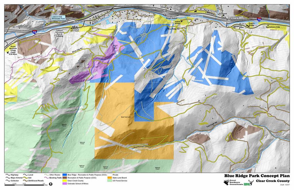
32 Downieville Exit 234 Potential Trailhead Dumont 70 Lawson Hole Whitewater Park Lawson Adventure Park & Lodging Exit 233 Potential Trailhead Mile Hi C Rafting & ATV Tours Intermediate Trails Family OHV Skills & Practice Area Gathering Area/ 3 3 Observation Weigh Station Clear Creek Animal Shelter Blue Ridge Rd LDS Potential Trailhead Exit 235 C Potential Trailhead C Road & Bridge 70 Sportsmans Club c Rocky Mountain Village Camp 0.25 Miles Silver City Rd Shelter/ Gathering 3 Interpretation I- School of Mines UV 712 Interpretation I- State Trust Land Trail Creek Rd Highway Major Arterial Collector Local 4x4-22 Miles USFS Roads Dirt/Gravel Roads Potential Trails - Open to All Uses 80 Inch Trail - All Vehicles - 9 Miles 65 Inch Trail - Up to ROVs - 6 Miles 50 Inch Trail - Up to ATVs Miles 18 Inch Trail - Dirt Bikes & All Bicycles Miles Existing Trails Blue Ridge - Recreation & Public Purpose (CCC) Recreation & Public Purpose (CCC) Clear Creek Blue Ridge Park Concept Plan Clear Creek Colorado School of Mines Miles I Draft: 1/14/17 Private State Land Board US Service -Preliminary-
33 intentionally blank


 to allow riders to develop their riding skills before")

34 Concept Plan Safety Training & Skills Practice Area The area would be located close to the trailhead and should be used as a special space for youth, beginner (e.g. adult beginners) practice and family experiences. There should be a diversity of trails in this area that are relatively easy to ride on and be designed for safety including good visibility on turns and at intersections. These trails should be wider to make them more stable and easier to ride but have many turns to limit travel speed. Most of these trails should be 50 inches wide to provide opportunities for children and youth who generally ride ATVs and dirt bikes. It should be easy for parents and trainers to observe, supervise and coach riders in this area. Skills practice stations such as rocky sections, low bridge, small hill climb, and others can be located along these trails (with bypasses) to allow riders to develop their riding skills before traveling in the backcountry. Signs should clearly identify this area as a youth and beginner area advising caution. An information kiosk can provide important information such as a map, rules, emergency information, contacts, and information about sharing the area. Certain trails in this area can be closed for general use during permitted classes and training events. This area can also be used by schools and groups to teach various aspects of recreation, safety, ethics, etiquette, management, etc. A limited number of campsites in this area would allow families and trainers to provide basic facilities for groups using this area. Blue Ridge Road/Trail would provide access to this area, but is one lane wide and rough which would limit the size of campers and trailers that could access it. An OHV safety training area could be provided where participants receive instruction on how to safely ride OHVs. These types of designed safety and ethics training areas are few and far between and severely needed. This area could also be used for other recreation classes related to mountain biking, search and rescue, mountaineering, etc. The minimum size required for an OHV training area is 140 x 90 feet. The training area should be located close to the youth trails to allow convenient access following instruction. The training area should be surrounded with fencing or flagging during instruction to control access to the area, as well as prevent cross-traffic. A shade structure and tables could be provided for use during instruction. This site could be used for camping and general family use when training and other events are not being held. Page 26


35 B lue Ridge Recreation Area Information Kiosks and Signage An important purpose of the Recreation Area is to educate the public about safety and ethical recreational use of public lands. As a multiple-use recreation area, visitors will also need to be educated about sharing the area. To meet this goal, the Recreation Area should feature trail signs and information kiosks consistent with public land/trail management practices to convey these messages. Trail signs should provide user information such as etiquette, trail numbers, travel challenge level, directions for access and travel. Signs will also advise users to protect natural, cultural and historic resources in the area, and information kiosks will display area/trail maps, rules, and regulations. Signs and kiosks for dedicated training spaces will serve to reinforce information provided in training classes. The Recreation Area s natural resources, history, management, and designed features can also be interpreted to convey messages and interesting information. A quality trail map should be designed for the area and used on kiosks, as a folded print map, and as geospatial PDF map for use in the Avenza Maps App. High Quality Trail Map Example Downieville Potential Trailhead Exit 234 Family OHV Skills & Practice Area Weigh Station Animal Shelter 3Observation Intermediate Trails Clear Creek LDS Dumont Potential Trailhead Exit 23 CPotential Trailhead C Blue Ridge Rd Gathering Area/ 3 School of Mines er/ Gathering Location for Safety Training, Family Riding and Skills Practice in Blue Ridge Recreation Area pretation Interpretation I Page 27

36 Concept Plan General Recommendations The following general recommendations can be considered as part of additional planning, design, development and management of the Recreation Area. Clear Creek should make a strong commitment to the project to be in a better position to receive grant funding. Grant funding could come from sources such as Great Outdoors Colorado, Colorado OHV Grants Program, Recreational Trails Program, industry grants, etc. Gain diverse support and funding to improve eligibility for grants Provide a unique Recreation Area that will benefit many types of visitors Communicate a culture of sharing and cooperation a sandbox for all to share Provide new experiences over time keep it interesting Focus on quality trails and facilities Visitors will pay to use a Recreation Area if quality trails, facilities and experiences are provided Emphasis on family and beginner experiences. The Blue Ridge Recreation Area isn t large enough to be a destination based just on the miles of trails. Providing unique facilities and experiences will create interest. Opportunities for skills practice and safety training Identify long-term solutions for management and maintenance Engage the business community in solutions and to provide services Establish a volunteer organization to support the Recreation Area Establish an internship program to benefit youth and have access to human resources Create a strong education and information program to manage expectations and prevent issues Provide high quality maps to promote and inform (print, smart digital). Create a web page and on line map to promote and provide information roads needed for connectivity should/must be designated and managed for OHV use Phased implementation spread cost, learn lessons and build flexibility into solutions Host and provide facilities for Stay the Trail educational & training events Host recreation events & clinics to attract new visitors and expand programs Establish a multiple-use recreation advisory board to manage expectations, develop opportunities and resolve issues Serve as a demonstration site for multipleuse collaborative outdoor recreation, benefiting other agencies, communities, recreation groups, outdoor industry and others Identify opportunities and constraints associated with the planning Clear Creek Greenway trail Page 28

37 Blue Ridge Recreation Area Develop a detailed master plan and management plan including o NOHVCC four E s of OHV Management: Engineering, Education, Enforcement, Evaluation o Environmental and Cultural Resource Management o Air Quality and Sound o Fire and Risk Management o Volunteers and Sponsors o Maintenance Plan o Rules and Regulations o Security o Emergency medical services o Budget & Finance o Promotion and Awareness Page 29
38 Concept Plan Implementation The following table outlines a general list of tasks to establish the Blue Ridge Recreation Area. This list can be expanded in the future as more information is gained. Resources to implement the tasks have been suggested. Table. Blue Ridge Recreation Area Implementation Phases & Tasks Phase/ Task Phase 1 Planning, Design & Designation Establish a diverse advisory group to assist with recreation experiences, planning and management of the Recreation Area Establish a project web page to share information and improve communication. Keep interested stakeholders updated on tasks, information and meetings. Create and distribute a public use map for the Recreation Area Secure funding to continue with research, planning and design Finalize acquisition of a property to use as a trailhead and gathering area Research similar multiple-use recreation areas to understand lessons learned, costs, and requirements Prepare a detailed master plan to finalize Recreation Area uses, development, sustainability, standards, budget, and management Formal establishment of the Blue Ridge Recreation Area through Clear Creek Board of Commissioners Designated key roads as OHV routes based on the adopted master plan Explore establishment of a memorandum of understanding (MOU) with the USFS to provide access to roads and information to visitors Explore establishment of a MOU with the Colorado State Trust Lands and develop a lease agreement to manage the section of State Land contiguous with the Recreation Area Explore establishment of a MOU with Stay the Trail to assist with signs, programs and volunteers Explore potential trail easements or land acquisitions through key willing private land owners Potential Resources Community Groups Recreation Groups Industry Grants Industry Grants GOCO Colorado OHV Grants Industry Grants GOCO Colorado OHV Grants Industry Grants GOCO Colorado OHV Grants Page 30
39 Blue Ridge Recreation Area Table. Blue Ridge Recreation Area Implementation Phases & Tasks (continued) Phase/ Task Phase 2 Management & Development Secure additional funding for development and management Establish an annual budget for management and improvement of the Recreation Area Hire and train staff to manage the Recreation Area Create a strong education and information program to manage expectations and prevent issues Prepare a detailed management plan for the recreation area Develop trails and facilities Restore natural habitats, control weeds and conserve soils Ongoing evaluation and research to document lessons and share information Phase 3 - Adaptive Management & Innovation Secure additional funding for development and management Adapt trails, facilities and management to changing condition and uses Prepare annual implementation and management plans Engage the business community in solutions and to provide services Establish a volunteer organization Establish an internship program Host recreation events & clinics to attract new visitors and expand programs Engage the business community in solutions and to provide services Potential Resources GOCO Colorado OHV Grants Industry Grants Staff Stay the Trail Colorado OHV Grants Industry Grants GOCO Colorado OHV Grants Industry Grants Conservation groups CPW Volunteers GOCO Colorado OHV Grants Industry Grants GOCO Colorado OHV Grants Industry Grants Stay the Trail Page 31

40 Concept Plan Page 32
FINAL TESTIMONY 1 COMMITTEE ON RESOURCES UNITED STATES HOUSE OF REPRESENTATIVES. July 13, 2005 CONCERNING. Motorized Recreational Use of Federal Lands
 FINAL TESTIMONY 1 STATEMENT OF DALE BOSWORTH CHIEF Of the FOREST SERVICE UNITED STATES DEPARTMENT OF AGRICULTURE Before the SUBCOMMITTEE ON FORESTS AND FOREST HEALTH And the SUBCOMMITTEE ON NATIONAL PARKS,
13.1 REGIONAL TOURISM ISSUES AND SUMMARY OF FINDINGS
 13 REGIONAL TOURISM T he County of Mariposa s recreation needs and facilities fall within two categories: regional tourism and local recreation. This Element focuses on regional tourism issues related
Preferred Recreation Recommendations Stemilt-Squilchuck Recreation Plan March 2018
 Preferred Recreation Recommendations Stemilt-Squilchuck Recreation Plan March 2018 Below are the recommended recreation ideas and strategies that package together the various recreation concepts compiled
Dumont Dunes Special Recreation Management Area (SRMA)
") Dumont Dunes Special Recreation Management Area (SRMA) RMA/RECREATION MANAGEMENT ZONE (RMZ) OBJECTIVE(S) DECISIONS Objective Statement: Designate this area as a Special Recreation Management Area. To manage
Dumont Dunes Special Recreation Management Area (SRMA) RMA/RECREATION MANAGEMENT ZONE (RMZ) OBJECTIVE(S) DECISIONS Objective Statement: Designate this area as a Special Recreation Management Area. To manage
Logo Department Name Agency Organization Organization Address Information 5700 North Sabino Canyon Road
 Logo Department Name Agency Organization Organization Address Information United States Forest Coronado National Forest 5700 North Sabino Canyon Road Department of Service Santa Catalina Ranger District
Creating a User-Driven Long-Distance OHV Trail Through Partnering
 Joseph Raffaele Outdoor Recreation Planner U.S. Bureau of Land Management Yuma, Arizona Creating a User-Driven Long-Distance OHV Trail Through Partnering BLM is a multiple-use land management agency within
Thank you for the opportunity to comment on the proposed action to add trails and trailheads to the Red Rock District trail system.
 July 14, 2010 Jennifer Burns Red Rock Ranger District PO Box 20429 Sedona, AZ 86341 Flagstaff Biking Organization PO Box 23851 Flagstaff, AZ 86002 Dear Jennifer- Thank you for the opportunity to comment
CHAPTER 5. Chapter 5 Recreation Element
 CHAPTER 5 Recreation Element Chapter 5 Recreation Element The Recreation Element of the Meyers Area Plan is a supplement to the Recreation Element of the TRPA Regional Plan and the El Dorado County General
Table of Contents. page 3 Long term Goals Project Scope Project History. 4 User Groups Defined Trail Representative Committee. 5 Trail Users Breakdown
 Launched April 27th, 2010 1 Table of Contents page 3 Long term Goals Project Scope Project History 4 User Groups Defined Trail Representative Committee 5 Trail Users Breakdown 13 Trail Users Desires 16
CRANE LAKE TRAILS NETWORK AND SPACES
 CRANE LAKE TRAILS NETWORK AND SPACES AREA TRAILS COMMUNITY TRAILS GOLD COAST TRAIL LAKE PARK OPTION ONE LAKE PARK OPTION TWO OVERFLOW TRAILHEAD PARKING THE GATE AREA TRAILS Trails are a major resource
DRAFT - APRIL 13, 2007 ROUTING STUDY FOR TRAIL CONNECTIONS BETWEEN CALAIS AND AYERS JUNCTION
 DRAFT - APRIL 13, 2007 ROUTING STUDY FOR TRAIL CONNECTIONS BETWEEN CALAIS AND AYERS JUNCTION Abstract The vision for the East Coast Greenway is an off-road urban trail system running from Calais, Maine
March 14, SUBJECT: Public input to the Bureau of Land Management, Gunnison Field Office, Travel Management Plan
 March 14, 2019 Delivered via email to ewaters@blm.gov Elijah Waters Field Manager BLM Gunnison Field Office Gunnison, CO 81230 SUBJECT: Public input to the Bureau of Land Management, Gunnison Field Office,
Rogue River Access and Management Plan Draft Alternatives
 Rogue River Access and Management Plan Draft Alternatives The Rogue River Access and Management Plan was initiated in December, 2011 and is being led by Jackson County Parks (JCP) and Oregon Department
EXECUTIVE SUMMARY PROGRAM DEVELOPMENT REPORT PURPOSE EXISTING SETTING EXPANDING PARKLAND
 EXECUTIVE SUMMARY PROGRAM DEVELOPMENT REPORT PURPOSE As the culmination of the first phase of the master planning process, this Program Development Report creates the framework to develop the Calero County
April 10, Mark Stiles San Juan Public Lands Center Manager 15 Burnett Court Durango, CO Dear Mark,
 Mark Stiles San Juan Public Lands Center Manager 15 Burnett Court Durango, CO 81301 Dear Mark, We are pleased to offer the following comments on the draft San Juan Public Lands Center management plans
City of Durango 5.8 FUNDING TRAILS DEVELOPMENT
 5.8 FUNDING TRAILS DEVELOPMENT The City has been successful in establishing dedicated local funding sources as well as applying for grants to develop the City s trail system, having received nearly $2.4
Mt. Hood National Forest
 United States Department of Agriculture Forest Service Mt. Hood National Forest Zigzag Ranger District 70220 E. Highway 26 Zigzag, OR 97049 503-622-3191 Fax: 503-622-5622 File Code: 1950-1 Date: June 29,
Kelly Motorized Trails Project Proposed Action
 Kelly Motorized Trails Project Proposed Action November 28, 2011 The Flagstaff Ranger District of the Coconino National Forest is seeking public input on the proposed Kelly Motorized Trails Project (formerly
Proposal to Redevelop Lower Kananaskis River-Barrier Lake. Bow Valley Provincial Park. Frequently Asked Questions
 Proposal to Redevelop Lower Kananaskis River-Barrier Lake Bow Valley Provincial Park Frequently Asked Questions What is being proposed? What are the details of the proposal? Where is the project area located?
Proposed Action. Payette National Forest Over-Snow Grooming in Valley, Adams and Idaho Counties. United States Department of Agriculture
 United States Department of Agriculture Forest Service January 2012 Proposed Action Payette National Forest Over-Snow Grooming in Valley, Adams and Idaho Counties Payette National Forest Valley, Adams
GATEWAY PHASE 2. U.S. Forest Service and the Mount Shasta Trails Association
 GATEWAY PHASE 2 U.S. Forest Service and the Mount Shasta Trails Association PROJECT DEVELOPMENT Brief history - Gateway Phase 1 - IMBA conceptual plan - BikeShasta: concert series - USFS & MSTA partnered
Non-motorized Trail Plan & Proposal. August 8, 2014
 Town of Star Valley Ranch, Wyoming and the Star Valley Ranch Association in partnership with the USDA Forest Service, Bridger-Teton National Forest, Greys River Ranger District Non-motorized Trail Plan
Hermosa Area Preservation The Colorado Trail Foundation 4/11/2008
 Hermosa Area Preservation The Colorado Trail Foundation 4/11/2008 Legend d o Tr ail NPA - National Protection Area ra NCA - National Conservation Area o e C Th The Colorado Trail lo FS inventoried Roadless
RE: Access Fund Comments on Yosemite National Park Wilderness Stewardship Plan, Preliminary Ideas and Concepts
 September 30, 2016 Superintendent Yosemite National Park Attn: Wilderness Stewardship Plan P.O. Box 577 Yosemite, CA 95389 RE: Access Fund Comments on Yosemite National Park Wilderness Stewardship Plan,
Chapter 6: POLICY AND PROCEDURE RECOMMENDATIONS
 Chapter 6 POLICY AND PROCEDURE RECOMMENDATIONS FOR SRRA Below are seven policy elements that should be considered for adoption by the Southwest Regional Recreation Authority of Virginia: 1. Develop strategies
AGENDA ITEM 5 D WAKULLA ENVIRONMENTAL INSTITUTE (WEI) TRAIL FEASIBILITY STUDY
 TRAIL FEASIBILITY STUDY") March 19, 2018 AGENDA ITEM 5 D WAKULLA ENVIRONMENTAL INSTITUTE (WEI) TRAIL FEASIBILITY STUDY TYPE OF ITEM: Action STATEMENT OF ISSUE The Wakulla Environmental Institute (WEI) Trail is one of several trails
March 19, 2018 AGENDA ITEM 5 D WAKULLA ENVIRONMENTAL INSTITUTE (WEI) TRAIL FEASIBILITY STUDY TYPE OF ITEM: Action STATEMENT OF ISSUE The Wakulla Environmental Institute (WEI) Trail is one of several trails
Paiute Trail Hatfield-McCoy Highwood Mountains
 Paiute Trail Hatfield-McCoy Highwood Mountains Located in Central Utah Main trail is 238 miles 550 miles of designated side trails Links 16 communities in 4 counties Ranges from 5,200 to 11,500 feet Great
Rule Governing the Designation and Establishment of All-Terrain Vehicle Use Trails on State Land
 Rule Governing the Designation and Establishment of All-Terrain Vehicle Use Trails on State Land 1.0 Authority 1.1 This rule is promulgated pursuant to 23 V.S.A. 3506. Section 3506 (b)(4) states that an
Flow Stand Up Paddle Board Parkway Plan Analysis
 Regional Parks Department Jeffrey R. Leatherman, Director County of Sacramento Divisions Administration Golf Leisure Services Maintenance Rangers Therapeutic Recreation Services Flow Stand Up Paddle Board
Village of Taos Ski Valley 2015 Master Plan. Recreation Element
 Village of Taos Ski Valley 2015 Master Plan Taos Ski Valley is known across the world for skiing and winter sports, but the Village has more to offer than advanced skiing terrain and short lift lines.
Trail Assessment Report
 Trail Assessment Report Trail Options for the Bear Creek Canyon located in Pikes Peak Ranger District, Pike National Forest and on Colorado Springs Utility Lands Due to the presence of a unique species
Proposal to Redevelop Lower Kananaskis River-Barrier Lake. Bow Valley Provincial Park
 Frequently Asked Questions Proposal to Redevelop Lower Kananaskis River-Barrier Lake Bow Valley Provincial Park Frequently Asked Questions What has been decided? What are the details of the plan? What
ROAD AND TRAIL PROJECT APPROVAL
 ROAD AND TRAIL PROJECT APPROVAL www.marincountyparks.org Marin County Parks, 3501 Civic Center Dr, Suite 260, San Rafael, CA 94903 DATE: July 12, 2017 PRESERVE: Gary Giacomini Open Space Preserve PROJECT:
St. Joe Travel Management EA CULTURAL RESOURCES
 St. Joe Travel Management EA CULTURAL RESOURCES Bruce Gibson May 2015 Regulatory Framework Forest Plan The Idaho Panhandle National Forests (IPNF) Forest Plan requires systematic cultural resource inventory
MASTER PLAN EXECUTIVE SUMMARY
 Biscuit Run State Park Scottsville Road (State Route 20) Charlottesville, VA 22902 Biscuit Run State Park MASTER PLAN EXECUTIVE SUMMARY Department of Conservation and Recreation Division of Planning and
Buford / New Castle Motorized Trail
 Buford / New Castle Motorized Trail Rifle Ranger District, White River National Forest Garfield County, Colorado Comments Welcome The Rifle Ranger District of the White River National Forest welcomes your
Kit Carson-Challenger Ridge Trail Project Annual Performance Report-2014 October 22, 2014
 1 Kit Carson-Challenger Ridge Trail Project Annual Performance Report-2014 October 22, 2014 Willow Lake and Kit Carson Peak 2 SUMMARY The Rocky Mountain Field Institute began Phase 1 of a multi-phase,
Steer Creek Campground Corral
 Steer Creek Campground Corral Purpose and Need The purpose of this project is to increase the availability of camping experiences and services for equestrians at the Steer Creek Campground in the Samuel
BACKCOUNTRY TRAIL FLOOD REHABILITATION PROGRAM
 BACKCOUNTRY TRAIL FLOOD REHABILITATION PROGRAM Backcountry Trail Flood Rehabilitation A June 2013 Flood Recovery Program Summary In June 2013, parts of Southern Alberta were devastated from significant
RUSHMORE CONNECTOR TRAIL PROPOSAL
 PURPOSE AND NEED Background The U.S. Forest Service, Black Hills National Forest (Forest Service) has received a special use permit application from the State of South Dakota Department of Game, Fish and
10/25/2013. What is the SCORP?! 2013 Local Government Survey 2013 Statewide Public Survey Advisory Group Priority Areas Your Suggestions!
 COLORADO OUTDOOR RECREATION TRENDS RESULTS FROM THE SCORP AND STATEWIDE Colorado Outdoor Recreation Resource Partnership September 2013 PRESENTATION What is the SCORP?! 2013 Local Government Survey 2013
ROYAL GORGE PARK and RECREATION AREA. A Feat of Natural and Man-Made Engineering
 ROYAL GORGE PARK and RECREATION AREA A Feat of Natural and Man-Made Engineering As Growth Resumed in the 1870 s Town Leaders Began to Envision a Tourist Industry. The Arkansas River Canyon was advertised
Daisy Dean Trail 628/619 ATV Trail Construction
 Background and Purpose and Need The Daisy Dean ATV Trail Construction Project is located in the Little Belt Mountains, Musselshell Ranger District, Lewis and Clark National Forest approximately 32 miles
2. Goals and Policies. The following are the adopted Parks and Trails Goals for Stillwater Township:
 D. PARKS AND TRAILS 1. Introduction Stillwater Township s population is relatively low, with most residents living on rural residences on large lots. The need for active park space has been minimal in
Business Item No XXX. Proposed Action That the Metropolitan Council approve the Coon Creek Regional Trail Master Plan.
 Business Item No. 2015-XXX Metropolitan Parks and Open Space Commission Meeting date: July 7, 2015 For the Community Development Committee meeting of July 20, 2015 For the Metropolitan Council meeting
Understanding the caring capacity of the visitor experience Provide facilities to support a high level user experience Address visual quality through
 Understanding the caring capacity of the visitor experience Provide facilities to support a high level user experience Address visual quality through recreation ecological restoration opportunities Collaboration
September 14, Comments of the Colorado Trail Foundation On the USFS Scoping Notice of August 13, 2010 RE: the relocation of the CDNST/CT Page 1
 THE COLORADO TRAIL FOUNDATION Comments on the U.S. Forest Service Scoping Notice of August 13, 2010 Regarding the Relocation of THE COLORADO TRAIL AND CONTINENTAL DIVIDE NATIONAL SCENIC TRAIL From La Garita
South Colony Basin Recreation Fee Proposal
 South Colony Basin Recreation Fee Proposal Purpose and Need for Collecting Fees in South Colony Basin: Forest Service appropriated funds have not been sufficient to maintain current recreational services
DATE: 23 March, 2011 TO: Communities FROM: BlazeSports America. RE: Accessible Trails Checklist 1
 M E M O R A N D U M DATE: 23 March, 2011 TO: Communities FROM: BlazeSports America RE: Accessible Trails Checklist 1 The purpose of the Accessible Trails Checklist (below) is to help the community review
Longmont to Boulder Regional Trail Jay Road Connection DRAFT FINAL REPORT
 Longmont to Boulder Regional Trail Jay Road Connection DRAFT FINAL REPORT December 2018 Project Summary Boulder County, Colorado, in partnership with the City of Boulder, is evaluating options for multi-use
Procedure for the Use of Power-Driven Mobility Devices on Mass Audubon Sanctuaries 1 September 17, 2012
 Procedure for the Use of Power-Driven Mobility Devices on Mass Audubon Sanctuaries 1 September 17, 2012 Background As part of Mass Audubon s mission to preserve the nature of Massachusetts for people and
GREENWOOD VEGETATION MANAGEMENT
 APPENDIX G GREENWOOD VEGETATION MANAGEMENT PROJECT RECREATION RESOURCE REPORT Prepared by: Laurie A. Smith Supervisory Forester Stearns Ranger District Daniel Boone National Forest August 4, 2016 The
Continental Divide National Scenic Trail Legislative History and Planning Guidance
 Continental Divide National Scenic Trail Legislative History and Planning Guidance Legislation, Policy, and Direction Regarding National Scenic Trails The National Trails System Act, P.L. 90-543, was passed
Restore and implement protected status that is equivalent, or better than what was lost during the mid-1990 s
 THE ROSSLAND RANGE, OLD GLORY AREA. Executive summary. The Friends of the Rossland Range Society, on behalf of the local outdoor community, seeks to accomplish the following with respect to the Old Glory
Response to Public Comments
 Appendix D Response to Public Comments Comment Letter # Response 1, 2, 3, 4, 5, 7, 8, 9, 10, 11, 12, 13, 14, 15, 16, 17, 18, 19, 20, 22, 23, 24, 25, 26, 27, 29, 30, 31, 32, 33, 34, 35, 36, 37, 38, 39,
National Recreation Trail Update Form
 National Recreation Trail Update Form Introduction Thank you for taking the time to complete this form. Your assistance will help ensure that the National Recreation Trail (NRT) database is complete and
S Central Coast Heritage Protection Act APRIL 21, 2016
 STATEMENT OF GLENN CASAMASSA ASSOCIATE DEPUTY CHIEF, NATIONAL FOREST SYSTEM U.S. FOREST SERVICE U.S. DEPARTMENT OF AGRICULTURE BEFORE THE UNITED STATES SENATE COMMITTEE ON ENERGY AND NATURAL RESOURCES
MANAGEMENT DIRECTION STATEMENT June, 1999
 Thompson River District MANAGEMENT DIRECTION STATEMENT June, 1999 for Roche Lake Provincial Park Ministry of Environment Lands and Parks BC Parks Division Table of Contents I. Introduction A. Setting
MONTEREY REGIONAL AIRPORT MASTER PLAN TOPICAL QUESTIONS FROM THE PLANNING ADVISORY COMMITTEE AND TOPICAL RESPONSES
 MONTEREY REGIONAL AIRPORT MASTER PLAN TOPICAL QUESTIONS FROM THE PLANNING ADVISORY COMMITTEE AND TOPICAL RESPONSES Recurring topics emerged in some of the comments and questions raised by members of the
National Forests and Grasslands in Texas
 United States Department of Agriculture Forest Service National Forests and Grasslands in Texas Sam Houston NF 394 FM 1375 West New Waverly, Texas 77358 Phone 936-344-6205 Dear Friends, File Code: 1950
Dungeness Recreation Area County Park Master Plan
 Dungeness Recreation Area County Park Public Outreach Meeting October 10, 2007 Project Overview USFWS Site Dungeness Recreation Area County Park Meeting Objectives: Re-Introduce project; provide status
F. Forest Recreation Management
 F. Forest Recreation Management F.1) Park and Recreation Management F.1.A. Program Overview. The park and recreation program has been in existence since 1980. With ever increasing outdoor recreation demands
Crystal Lake Area Trails
 Lake Area Trails Welcome to the Lake area of the Big Snowy Mountains! This island mountain range in central Montana features peaks reaching to 8,600 feet and long, high ridges from which vistas of the
At the time, the portion of the line through Eagle County remains wholly under the ownership of Union Pacific Railroad (UP).
.") Chapter 5 The Railroad Corridor as a Trail Corridor The intent of this chapter is to identify how the rail corridor, if available for lease or purchase in all or part, could be incorporated into the core
Chapter 5 The Railroad Corridor as a Trail Corridor The intent of this chapter is to identify how the rail corridor, if available for lease or purchase in all or part, could be incorporated into the core
RED MOUNTAIN HISTORIC DISTRICT ENHANCEMENT Grand Mesa, Uncompahgre, Gunnison National Forests Ouray Ranger District
 RED MOUNTAIN HISTORIC DISTRICT ENHANCEMENT Grand Mesa, Uncompahgre, Gunnison National Forests Ouray Ranger District Project Summary The Red Mountain President s Initiative Project proposes a comprehensive
Federal Outdoor Recreation Trends Effects on Economic Opportunities
 United States Department of Agriculture Federal Outdoor Recreation Trends Effects on Economic Opportunities The Forest Service National Center for Natural Resources Economic Research is assisting the Federal
Trail Phasing Plan. Note: Trails in the Clear Creek Canyon area (Segments will be finalized in the future to minimize wildlife impacts
 Note: Trails in the Clear Creek Canyon area (Segments 2 5 and a future JCOS connection) will be finalized in the future to minimize wildlife impacts Trail Phasing Plan P Parking 3 Easy Trail Intermediate
WASHINGTON STATE PARKS AND RECREATION COMMISSION POLICY/PROCEDURE
 WASHINGTON STATE PARKS AND RECREATION COMMISSION POLICY/PROCEDURE 65-13-1 Use of Other Power-Driven Mobility Devices by Persons with Mobility Disabilities at State Park Facilities See Also: 28 CFR 35 Title
Committee Report. Community Development Committee For the Metropolitan Council meeting of August 12, Business Item No.
 Committee Report Business Item No. 2015-168 Community Development Committee For the Metropolitan Council meeting of August 12, 2015 Subject: Coon Creek Regional Trail Master Plan, Anoka County Proposed
BOISE RIDGE TO RIVERS FOURTH QUARTER PARTNERSHIP MEETING DEPARTMENT OF PARKS AND RECREATION TUESDAY, JULY 25 TH :00 A.M.
 BOISE RIDGE TO RIVERS FOURTH QUARTER PARTNERSHIP MEETING DEPARTMENT OF PARKS AND RECREATION TUESDAY, JULY 25 TH 2017 8:00 A.M. Partners present: Sara Arkle, Boise City Parks and Recreation (City); Doug
Wallace Falls State Park Classification and Management Planning Stage 3 Preliminary Recommendations July 18, 2018 Sultan City Hall
 Wallace Falls State Park Classification and Management Planning Stage 3 Preliminary Recommendations July 18, 2018 Sultan City Hall Thanks for coming! This document contains State Parks preliminary recommendations
Tahoe National Forest Over-Snow Vehicle Use Designation
 Tahoe National Forest Over-Snow Vehicle Use Designation USDA Forest Service Tahoe National Forest February 20, 2015 Introduction The Forest Service, U.S. Department of Agriculture will prepare an Environmental
Peter Axelson. Beneficial Designs, Inc. Minden, NV
 Peter Axelson Beneficial Designs, Inc. Minden, NV Arroya Sit Ski Mono Ski Dynamic Seating Spring Assist Cross Country Ski Hand Bike Adaptive Canoe Seating Available from Chosen Valley Canoe Accessories
Agenda: SASP SAC Meeting 3
 Agenda: SASP SAC Meeting 3 Date: 04/12/18 Public Involvement Plan Update Defining the System Recommended Classifications Discussion Break Review current system Outreach what we heard Proposed changes Classification
5.0 OUTDOOR RECREATION OPPORTUNITIES AND MANAGEMENT
 5.0 OUTDOOR RECREATION OPPORTUNITIES AND MANAGEMENT 5.1 Introduction This section describes the range of recreational activities that currently take place in Marble Range and Edge Hills Parks, as well
2014 STATEWIDE COMPREHENSIVE OUTDOOR RECREATION PLAN
 2014 STATEWIDE COMPREHENSIVE OUTDOOR RECREATION PLAN SUSTAINING COLORADO S OUTDOOR RECREATION FUTURE SECTION 1: INTRODUCTORY INFORMATION WHAT IS THE SCORP? The SCORP update is required every five years
January 14, Orange County Transportation Authority Attn: M2 NCCP/HCP 550 South Main Street P.O. Box Orange, CA
 Equestrian Trails, Inc. Corral 357 P.O. Box 1026 Trabuco Canyon, CA 92678 http://saddlebackcanyonriders.com/ President: James Iacono... 714-612-1789 January 14, 2016 Orange County Transportation Authority
Camping (Primitive) Camping (RV) Electrical Potable Water Grill Established Fire Pit Picnic Table
 Camping (RV) Electrical Potable Water Grill Established Fire Pit Picnic Table") Alden - 9th Road River Mile 777 Map: 38.20833, -98.32031 Managing Agency: Kansas Department of Wildlife, Parks & Tourism Nearest Community: Alden, Rice County Kansas Developed Amenities Provided Parking
Alden - 9th Road River Mile 777 Map: 38.20833, -98.32031 Managing Agency: Kansas Department of Wildlife, Parks & Tourism Nearest Community: Alden, Rice County Kansas Developed Amenities Provided Parking
Park Design and Location Criteria
 Park Design and Location Criteria This section is presented in the interest of assisting park and recreation agencies in the development of a system of parks and recreation areas. A recreation system is
Appendix A BC Provincial Parks System Goals
 Appendix A BC Provincial Parks System Goals The British Columbia Provincial Parks System has two mandates: To conserve significant and representative natural and cultural resources To provide a wide variety
AMERICAN S PARTICIPATION IN OUTDOOR RECREATION: Results From NSRE 2000 (With weighted data) (Round 1)
 (Round 1)") AMERICAN S PARTICIPATION IN OUTDOOR RECREATION: Results From NSRE 2000 (With weighted data) (Round 1) The emphasis of this report is on participation patterns across activities and segments of our society.
AMERICAN S PARTICIPATION IN OUTDOOR RECREATION: Results From NSRE 2000 (With weighted data) (Round 1) The emphasis of this report is on participation patterns across activities and segments of our society.
Silver Lake Park An Environmental Jewel for the Citizens of Prince William County
 Silver Lake Park An Environmental Jewel for the Citizens of Prince William County The Prince William Park Authority Mission Statement states: The Prince William County Park Authority will create quality
Tracy Ridge Shared Use Trails and Plan Amendment Project
 Tracy Ridge Shared Use Trails and Plan Amendment Project Scoping Document Forest Service Allegheny National Forest Bradford Ranger District McKean, County, Pennsylvania In accordance with Federal civil
BACKSTORY & MMBA RECOMMENDATIONS
 URGENT!! COMMENT PERIOD ENDS MONDAY, MARCH 5 TH, 5PM!! MONTANA MOUNTAIN BICYCLE ALLIANCE RECOMMENDED COMMENTS ON CUSTER GALLATIN FOREST PLAN REVISION, Proposed Actions WINTER 2018 The CGNF Forest Plan
PURPOSE AND NEED. Introduction
 Public Scoping: Allocation of Recreation Capacity for Commercial Outfitter Guide Services on North Kruzof Island Trails (Kruzof Island Outfitter Guide) PURPOSE AND NEED Introduction The U.S. Department
Schoolcraft Township is located in northeast Houghton County. A portion of the township borders Keweenaw County and Lake Superior.
 COMMUNITY DESCRIPTION Schoolcraft Township is located in northeast Houghton County. A portion of the township borders Keweenaw County and Lake Superior. The township is largely rural but has one main population
As outlined in the Tatshenshini-Alsek Park Management Agreement, park management will:
 Management Strategy General Strategy The priority management focus for the park is to ensure that its internationally significant natural, cultural heritage and recreational values are protected and that
Shelf Road Recreation Area 2015 BLM Annual Report of Rocky Mountain Field Institute Stewardship Under BLM Agreement L12AC20483 November 19, 2015
 Summary Shelf Road Recreation Area 2015 BLM Annual Report of Rocky Mountain Field Institute Stewardship Under BLM Agreement L12AC20483 November 19, 2015 Managed by the BLM Royal Gorge Field Office, Shelf
APPENDIX OFFICIAL MAP ORDINANCE OF HAMILTONBAN TOWNSHIP OFFICIAL MAP NARRATIVE
 APPENDIX A OFFICIAL MAP ORDINANCE OF HAMILTONBAN TOWNSHIP OFFICIAL MAP NARRATIVE INTRODUCTION: The Official Map of Hamiltonban Township has been prepared to identify those lands and features that Hamiltonban
2016 Trails Maintenance and Operating Costs
 2016 Trails Maintenance and Operating Costs Motorized Trails Maintenance for motorized trails comes from vehicle registration fees and a portion of the federal Recreation Trails Program (RTP) funds. The
RECREATION ACCESS AND COMMUNITY ENRICHMENT PLAN
 Template for facilitating Siskiyou County, the City of Yreka and the State of Jefferson in a RECREATION ACCESS AND COMMUNITY ENRICHMENT PLAN Access to the Mountains CREATING ACCESS TO PUBLIC AND PRIVATE
Section II. Planning & Public Process Planning for the Baker/Carver Regional Trail began in 2010 as a City of Minnetrista initiative.
 Section II Planning & Public Process Planning for the began in 2010 as a City of initiative. city staff began discussions with the Park District on the possibility of a north/south regional trail connection
National Recreation Trail Application for Designation
 National Recreation Trail Application for Designation Introduction Thank you for your interest in the National Recreation Trail (NRT) program. Completed NRT application packages must be submitted by December
Welcome to the future of Terwillegar Park a Unique Natural Park
 Welcome to the future of Terwillegar Park a Unique Natural Park 1 Introduction The Terwillegar Park Concept Plan study will develop an overall concept plan, management objectives and development guidelines
Subj: POLICY FOR MAINSIDE TRAIL USE AT MARINE CORPS BASE QUANTICO
 UNITED STATES MARINE CORPS MARINE CORPS BASE QUANTICO, VIRGINIA 22134-5001 MCBO 5090.4 B 04 MARINE CORPS BASE ORDER 5090.4 From: Commander To: Distribution List Subj: POLICY FOR MAINSIDE TRAIL USE AT MARINE
MORGAN CREEK GREENWAY Final Report APPENDICES
 APPENDICES MORGAN CREEK GREENWAY Appendix A Photos of Existing Conditions in Trail Corridor Photos of existing conditions Main trail corridor - February 2009 Photos of existing conditions south bank Morgan
Thank you for this third opportunity to comment on the proposed revisions to the Coconino National Forest Management plan.
 March 19, 2014 Flagstaff Biking Organization PO Box 23851 Flagstaff, AZ 86002 Vern Keller Coconino National Forest Attn: Plan Revision 1824 South Thompson Street Flagstaff, Arizona 86001 coconino_national_forest_plan_revision_team@fs.fed.us
LESSON 9 Recognizing Recreational Benefits of Wilderness
 LESSON 9 Recognizing Recreational Benefits of Wilderness Objectives: Students will: study, analyze, and compare recreation visitor days (RVD s) for Wilderness areas adjacent to their homes or nearest state,
Connie Rudd Superintendent, Black Canyon of the Gunnison National Park
 National Park Service U.S. Department of the Interior Black Canyon of the Gunnison National Park and Curecanti National Recreation Area Information Brochure #1 Wilderness and Backcountry Management Plan
APPENDIX C RECREATION OPPORTUNITY SPECTRUM PROCESS AND CLASSES
 APPENDIX C RECREATION OPPORTUNITY SPECTRUM PROCESS AND CLASSES RECREATION OPPORTUNITY SPECTRUM PROCESS Recreation area management objectives are defined through a planning process referred to as the Recreation